Artisanal Mining & Biosphere Reserves in Central Africa
|
|
|
- Mavis Summers
- 5 years ago
- Views:
Transcription


1 Artisanal Mining & Biosphere Reserves in Central Africa How to contribute from the Earth Sciences perspective Luc André Royal Museum for Central Africa


2 The ASM poverty trap How to alleviate this viscious circle The Congo case study Structure the mining code and cadastral polygons Shift ASM from illegal towards legal polygons Improving cartography The Rwanda-Burundi case study Reinforce geo-prospecting Transboundary Geology Conclusions
3 The ASM poverty trap (Hilson Hilson & pardie,, 2006) Low levels of technology And poor geo-prospecting Low recovery Low productivity Unskilled labour and inability to invest Low income In a balanced steady state: This circle might be: «the ladder that sends us to wealth» Being 3-5 times the income of other occupations itmaycontributeto povertyreduction!
4 The ASM poverty trap (Hilson Hilson & pardie,, 2006) Low levels of technology And poor geo-prospecting When it is destabilized! Low recovery Low productivity Unskilled labour and inability to invest Environmental damage Deteriorated quality of life and health Low income Poverty exacerbation Larger numbers of miners exploiting limited resources Clashes Biodiversity, educational and cultural damages Refugees Pressure on Commodities Environmental changes
5 The pressure on commodities is there and will grow

6 A strong pressure by refugees
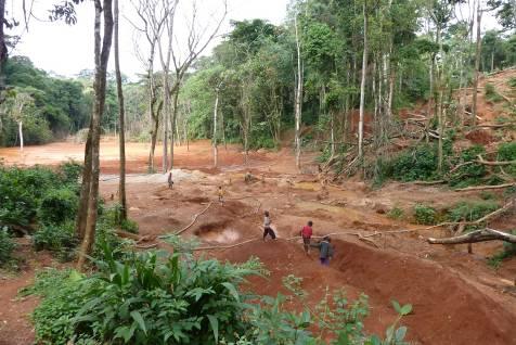
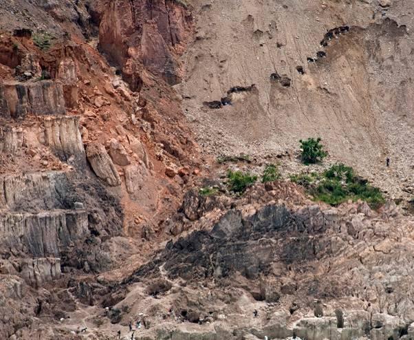
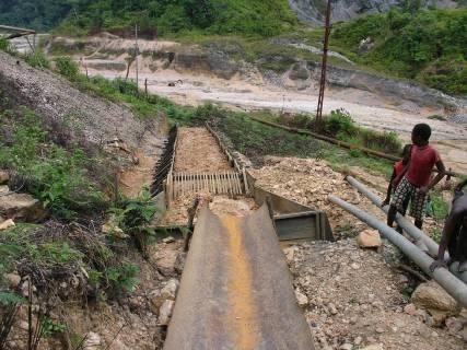
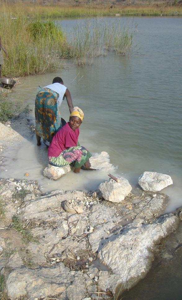
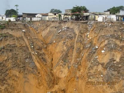
7 A sad imposed modernity: the artisanal mining in DRC


8 Gold Copper Diamond Coltan + Rare Earths, Platinium group, Cobalt, Germanium, U

9 Kasai/Diamond Diamond


10 Ituri: Gold Gold

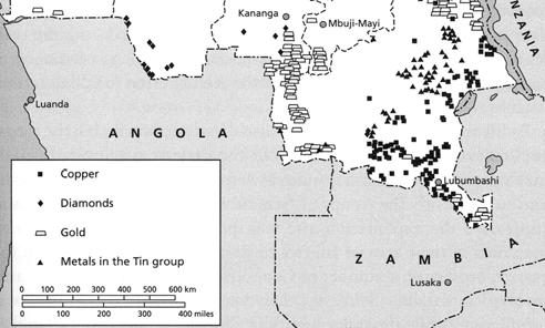

11 Katanga: Copper Copper


12 ppm Katemo Manda et al., 2011

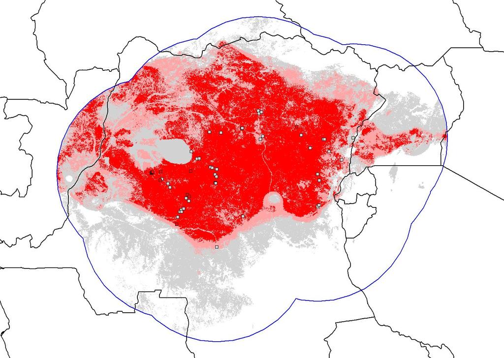
13 A rush on every potentials A geodesic signal

14 Kivu: Coltan Coltan
15 How to alleviate the pressure on the environment, the biosphere reserves? Low levels of technology And poor geo-prospecting Low recovery Low productivity Unskilled labour and inability to invest Low income Improvements in the technical, environmental and socioeconomic performance of the ASM sector hinge on the Formalization of miners through rights recognition Step 1: Delineate with precision the location of the mining permits and the reserve areas Step 2: Improve geo-prospections to delineate appropriate areas for: 1. Artisanal mining, 2.small mining and 3. industrial minings
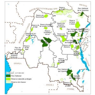
16 Improved mappings Integrate mining title maps with other information databases (Reserves, Resources potentialities, natural and environmental risks, Range modelings, Improve cartography Improve Geology Better prospecting Improved formations Exchange geological database Transboundary integrated geology Determine the environmental impacts
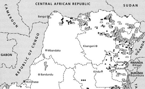
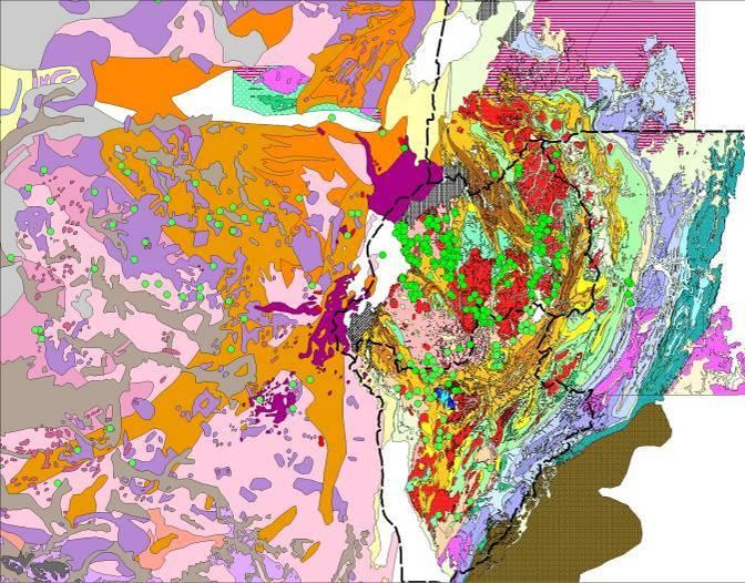
17 Integrated mapping Cadastral mapping and Parks and reserves D.R.C


18 The bonanza Delineate the permits


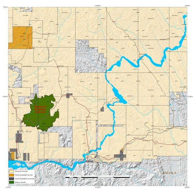
19 Parks and MABs The permits Yangambi Luki MAB reserves Lufira

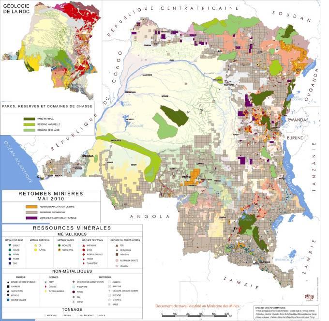
20 The integration

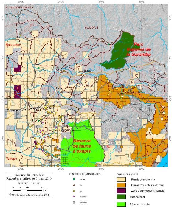
21 No or Very limited overlapping
22

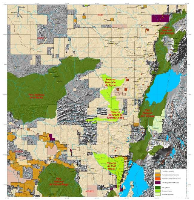
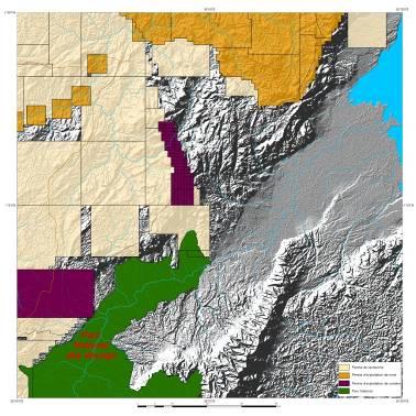
23


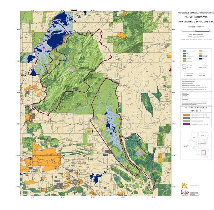
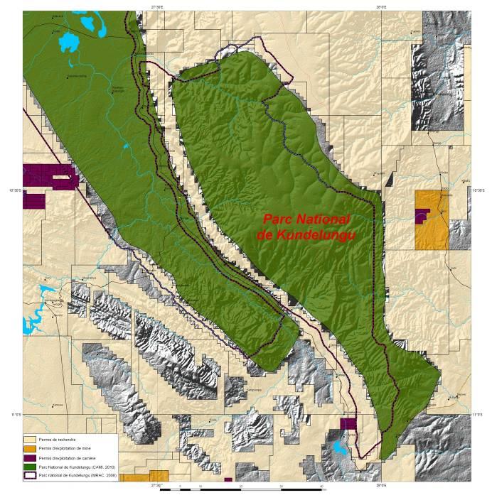
24 Upemba & Kundelungu

25 LUKI


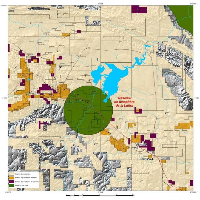

26 LUFIRA
27 Integrated mapping What else? Risks Species Range modeling D.R.C
28 The Natural Hazards Database for Central Africa Number of hazards registered: >500 mega-gullies People impacted: ~ 12.2 M The Natural Disaster Database for Central Africa, on line from october 5 th Number of events reported Floods & Storms Landslides Reported hydric disasters Year


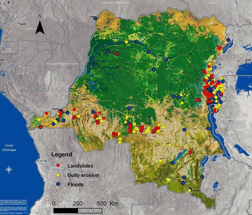
29 The importance of hydrological hazards in Central Africa


30 Study sites (UNIKIS) in the Salonga NP and near Kisangani : Collaboration with Emile Mulotwa Red dots: historical collection localities georeferenced in RMCA Congo Peacock

31
32 Improve mapping A geodesic survey is needed D.R.C


33 Belgian Geodesic surveys

34 Belgian


35 The difference between Rwanda, Burundi And DRC Coltan

36 New Kivu geological map
37 Rare Earth


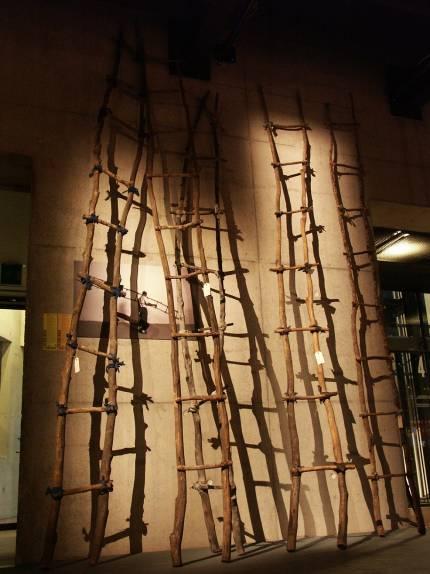
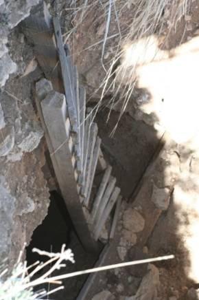
38 «Fetish Modernity» From april 8 th to september 11 th Stepladders, handmade by wannabe refugees

39
A century of experience: Training and knowledge transfer in Africa 30 years of activities: Past, present and future
 Royal Museum for central Africa A century of experience:1898-2012 Training and knowledge transfer in Africa 30 years of activities: Past, present and future Earth Sciences Field Geology Geodynamics Major
The UN-GGIM: Europe core data initiative to encourage Geographic information supporting Sustainable Development Goals Dominique Laurent, France
 INSPIRE conference Strasbourg 6 September 2017 The UN-GGIM: Europe core data initiative to encourage Geographic information supporting Sustainable Development Goals Dominique Laurent, France Introduction
Diplomarbeit. zur Erlangung des akademischen Grades Diplomingenieur für Kartographie
 Falkultät Forst-, Geo- und Hydrowissenschaften, Institut für Kartographie Diplomarbeit zur Erlangung des akademischen Grades Diplomingenieur für Kartographie Combination of Remote Sensing and Socio-Economic
Vulnerability mapping for sustainable hazard mitigation in the city of Bukavu, South Kivu DRCongo
 IAG/AIG REGIONAL CONFERENCE, 18th to 22nd Feb. 2011 Vulnerability mapping for sustainable hazard mitigation in the city of Bukavu, South Kivu DRCongo Sadiki Ndyanabo 1, Ine Vandecasteele 2, Jan Moeyersons
GGY 301: Research Methods
 GGY 301: Research Methods Course No GGY 301 Course Title Research Methods Core/Optional Core for Special Degree :This course provides students with a basic knowledge and understanding of the research methodology
URANIUM IN DRC Making a comeback
 REPUBLIQUE DEMOCRATIQUE DU CONGO Ministère des Mines CADASTRE MINIER REGIONAL TRAINING COURSE ON UNITED NATIONS FRAMEWORK CLASSIFICATION 2009 FOR EVALUATION OF URANIUM AND THORIUM RESOURCES AND TO LEVERAGE
A contribution to GEOSS from the SDI for Georesources in Africa
 A contribution to GEOSS from the SDI for Georesources in Africa A. TELLEZ-ARENAS BRGM, France in behalf of: Dr. Marc URVOIS Project Coordinator BRGM, France Mineral Resources Division INSPIRE Conference
UNESCO Earth Science Education Initiative in Africa Initial Activities
 UNESCO Earth Science Education Initiative in Africa Initial Activities S. Felix Toteu 1 and Sarah Gaines 2 1 UNESCO Nairobi Office, Kenya 2 UNESCO Headquarters, Paris In Arusha, Tanzania on 8 May 2008
RiskCity Training package on the Application of GIS for multi- hazard risk assessment in an urban environment.
 RiskCity Training package on the Application of GIS for multi- hazard risk assessment in an urban environment. Cees van Westen (Westen@itc.nl) & Nanette C. Kingma (Kingma@itc.nl) ITC: Training & Research
IGAD Climate Prediction and Applications Centre Monthly Bulletin, August 2014
 IGAD Climate Prediction and Applications Centre Monthly Bulletin, 1. HIGHLIGHTS/ ACTUALITES Rainfall activities were mainly observed over the central parts of the northern sector and western parts of equatorial
Quarterly Activities Report for the reporting ending 30 September 2013
 AS ASX Announcement 31 October 2013 ABN 23 106 296 106 Level 14, 31 Queen Street Melbourne Victoria 3000 T (+61 3) 8610 8633 F (+61 3) 8610 8666 W regalresources.com.au Quarterly Activities Report for
DEPARTMENT OF GEOLOGY AND MINERAL INDUSTRIES WAYS & MEANS SUBCOMMITTEE ON NATURAL RESOURCES MARCH 2, 2017
 DEPARTMENT OF GEOLOGY AND MINERAL INDUSTRIES WAYS & MEANS SUBCOMMITTEE ON NATURAL RESOURCES MARCH 2, 2017 1 ABOUT DOGAMI AGENCY MISSION, VISION & GOALS 2 Lidar image of a stream network along the Umpqua
Norwegian spatial data infrastructure supporting disaster risk management Norwegian Mapping Authority
 Norwegian spatial data infrastructure supporting disaster risk management Norwegian Mapping Authority Arvid Lillethun, Norwegian Mapping Authority Land and Poverty 2018 Conference, World Bank 19.-23. March
RESOURCE REPORTING THE FIRST STEP IN SUSTAINABLE MINING. Committee for Mineral Reserves International Reporting Standards
 RESOURCE REPORTING THE FIRST STEP IN SUSTAINABLE MINING 1 B Y J O H N C L I F F O R D ( D E P U T Y C H A I R M A N C R I R S C O ) A N D N I A L L W E A T H E R S T O N E ( C H A I R M A N C R I S C O
Comprehensive Community Planning
 Comprehensive Community Planning Session Three: Preparing to Plan Part Two - Day 2 AM - Zoning and Land Use Decision Continued How does the Land Use Plan connect to the CCP? LUP direction included in /
A d v a n c e d G e o l o g i c a l E n g i n e e r i n g ( 1 2 A ) 40S/40E/40M
 40S/40E/40M") 9 1 5 2 A d v a n c e d G e o l o g i c a l E n g i n e e r i n g ( 1 2 A ) 40S/40E/40M 9 1 5 2 A d v a n c e d G e o l o g i c a l E n g i n e e r i n g ( 1 2 A ) 4 0 S / 4 0 E / 4 0 M Course Description
9 1 5 2 A d v a n c e d G e o l o g i c a l E n g i n e e r i n g ( 1 2 A ) 40S/40E/40M 9 1 5 2 A d v a n c e d G e o l o g i c a l E n g i n e e r i n g ( 1 2 A ) 4 0 S / 4 0 E / 4 0 M Course Description
Intensive Field Based Exploration Program Commences at Dobsina Cobalt-Nickel-Copper Sulphide Project
 5 th July 2017 Intensive Field Based Exploration Program Commences at Dobsina Cobalt-Nickel-Copper Sulphide Project Intensive site based exploration has commenced at Dobsina Co-Ni Project. Activities include:
CONTANGO ORE, INC. Contango ORE Announces Results of 2012 Exploration Program
 CONTANGO ORE, INC. NEWS RELEASE Contango ORE Announces Results of 2012 Exploration Program December 6, 2012 HOUSTON, TEXAS Contango ORE, Inc. (CTGO.PK) announced today the preliminary results on a portion
Assessing Hazards and Risk
 Page 1 of 6 EENS 204 Tulane University Natural Disasters Prof. Stephen A. Nelson Assessing Hazards and Risk This page last updated on 07-Jan-2004 As discussed before, natural disasters are produced by
At the heart of Africa : The DRC
 The D.R. Congo in a context of commodities falling prices - Towards a Strategic Copper? Dieudonné-Louis TAMBWE K. a-m. CTCPM Deputy Coordinator DR Congo Ministry of Mines Lisbon, March 2016 The Country
Revealing the interaction between Society and Nature. DesInventar, disaster inventories for damage and loss assessment
 UNFCCC Regional expert meeting on a range approaches to address loss and damage associated with the adverse effects climate change, including impacts related to extreme weather events and slow onset events
GEO Geohazards Community of Practice
 GEO Geohazards Community of Practice 1) Co-Chair of GHCP With input from: Stuart Marsh, GHCP Co-Chair Francesco Gaetani, GEO Secretariat and many GHCP contributors 1) Nevada Bureau of Mines and Geology
Foundation Geospatial Information to serve National and Global Priorities
 Foundation Geospatial Information to serve National and Global Priorities Greg Scott Inter-Regional Advisor Global Geospatial Information Management United Nations Statistics Division UN-GGIM: A global
Geological Survey of Canada Lands and Minerals Sector Natural Resources Canada OneGeology, June 2018
 Geological Survey of Canada Lands and Minerals Sector Natural Resources Canada OneGeology, June 2018 Geological Survey of Canada Mission The Geological Survey of Canada provides public geoscience knowledge
NEWS RELEASE TSX: ELD NYSE: EGO September 6, Eldorado Announces Drilling Results from KMC Project, Serbia
 NEWS RELEASE TSX: ELD NYSE: EGO September 6, 2016 Eldorado Announces Drilling Results from KMC Project, Serbia VANCOUVER, BC, September 6, 2016 Eldorado Gold Corporation, ( Eldorado or the Company ) is
UNITED NATIONS EDUCATIONAL, SCIENTIFIC AND CULTURAL ORGANIZATION. Man and the Biosphere (MAB) Programme and International Geosciences Programme (IGCP)
 Programme and International Geosciences Programme (IGCP)") UNITED NATIONS EDUCATIONAL, SCIENTIFIC AND CULTURAL ORGANIZATION Man and the Biosphere (MAB) Programme and International Geosciences Programme (IGCP) Expert Meeting on Biosphere Reserves and Earth Resources
UNITED NATIONS EDUCATIONAL, SCIENTIFIC AND CULTURAL ORGANIZATION Man and the Biosphere (MAB) Programme and International Geosciences Programme (IGCP) Expert Meeting on Biosphere Reserves and Earth Resources
D.R. CONGO : MINING OF VAST HISTORICAL EXPLORATION
 INTRODUCTION D.R. CONGO : MINING OF VAST HISTORICAL EXPLORATION DATABASES MAY REVEAL NEW MINERAL RESOURCES The vast majority of known mineral resources of the Democratic Republic of the Congo (DRC) are
For personal use only
 24 April 2015 ASX Code: RER CLARIFICATION ANNOUNCEMENT REGAL RESOURCES SIGNS MOA WITH IVANHOE MINES TO EXPLORE HIGHLY PROSPECTIVE PERMITS IN DRC COPPERBELT HIGHLIGHTS Regal has entered into a binding conditional
POTENTIAL OF THE DONGWE COPPER GOLD PROJECT
 POTENTIAL OF THE DONGWE COPPER GOLD PROJECT By Nathan Sabao, P.Geo. September 2015 1 TABLE OF CONTENTS Page 1.0 EXECUTIVE SUMMARY 1 2.0 LOCATION 2 3.0 ACCESS 2 4.0 GEOLOGY 3 5.0 PREVIOUS DRILLING 5 6.0
Australia s Response To The Chile Technological Roadmap In Mining : The University of Queensland Experience
 Australia s Response To The Chile Technological Roadmap In Mining : The University of Queensland Experience CHALLENGE 1: Underground mining: Development of large-scale deep mining Professor and Chair In
SINKHOLES WHERE AND WHY THEY FORM
 SINKHOLES WHERE AND WHY THEY FORM In the wake of the sinkhole that developed beneath a Florida man s bedroom, tragically killing the man as he was sucked into the earth, many people are searching for information.
IGAD Climate Prediction and and Applications Centre Monthly Bulletin, August May 2015
 . IGAD Climate Prediction and and Applications Centre Monthly Bulletin, August May 2015 For referencing within this bulletin, the Greater Horn of Africa (GHA) is generally subdivided into three sub-regions:
Disaster Risk Assessment: Opportunities for GIS and data management with Open DRI
 Disaster Risk Assessment: Opportunities for GIS and data management with Open DRI Jacob Opadeyi Department of Geomatics Engineering and Land Management, The University of the West Indies, St. Augustine,
The Myanmar Mineral Exploration Handbook
 The Myanmar Mineral Exploration Handbook GEOLOGY AND RESOURCE POTENTIAL OF MYANMAR (BURMA) XPLORE GLOBAL Ltd. BASED IN MAIDENHEAD UK Copyright Details The Myanmar Mineral Exploration Handbook: Geology
Advancing Geoscientific Capability. Geological Survey of Finland
 Advancing Geoscientific Capability Geological Survey of Finland GTK in brief The Geological Survey of Finland (GTK) is one of the largest European centres of excellence in assessment, research and the
A Journey in the Geology of Cyprus. Lectures and Excursions Programme (January June 2014)
") A Journey in the Geology of Cyprus Lectures and Excursions Programme (January June 2014) B A N K O F C UPRUS C U L T UR A L F O UND A T I O N A Journey in the Geology of Cyprus In the framework of the
A Journey in the Geology of Cyprus Lectures and Excursions Programme (January June 2014) B A N K O F C UPRUS C U L T UR A L F O UND A T I O N A Journey in the Geology of Cyprus In the framework of the
UNESCO s Earth Science. Education Initiative in Africa. United Nations Educational, Scientific and Cultural Organization
 UNESCO s Earth Science Education Initiative in Africa United Nations Educational, Scientific and Cultural Organization Few milestones First International Conference on African and Arabian Geoparks 2011,
CROCODILE GOLD FILES TECHNICAL REPORTS FOR FOSTERVILLE AND COSMO GOLD MINES AND PROVIDES ANNUAL GENERAL MEETING INFORMATION
 65 Queen Street West Suite 825, P.O. Box 75 Toronto, Ontario M5H 2M5 Canada CROCODILE GOLD FILES TECHNICAL REPORTS FOR FOSTERVILLE AND COSMO GOLD MINES AND PROVIDES ANNUAL GENERAL MEETING INFORMATION May
I C P A C. IGAD Climate Prediction and Applications Centre Monthly Climate Bulletin, Climate Review for March 2018
 No. ICPAC/02/311 Bulletin Issue April 2018 I C P A C IGAD Climate Prediction and Applications Centre Monthly Climate Bulletin, Climate Review for March 2018 1. INTRODUCTION This bulletin reviews the March
Poverty and Hazard Linkages
 Poverty and Hazard Linkages Global Risk Identification Programme Proposal Development Coordination Meeting Friday, 19 May 2006 CIESIN Earth Institute Columbia University www.ciesin.columbia.edu Data Improvements
CLIMATE RESILIENT ALTITUDINAL GRADIENTS (CRAGs)
") CLIMATE RESILIENT ALTITUDINAL GRADIENTS (CRAGs) BUILDING CLIMATE CHANGE RESILIENCE IN THE KIVU- RUSIZI WATERSHEDS Great Lake Conference Entebbe 2017 Chris Magero WHAT ARE CRAGs? Climate-Resilient Altitudinal
CLIMATE RESILIENT ALTITUDINAL GRADIENTS (CRAGs) BUILDING CLIMATE CHANGE RESILIENCE IN THE KIVU- RUSIZI WATERSHEDS Great Lake Conference Entebbe 2017 Chris Magero WHAT ARE CRAGs? Climate-Resilient Altitudinal
THE ROLE OF SEAMIC IN SUSTAINABLE MINERAL RESOURCES DEVELOPMENT IN AFRICA
 THE ROLE OF SEAMIC IN SUSTAINABLE MINERAL RESOURCES DEVELOPMENT IN AFRICA Ketema Tadesse Director General-SEAMIC Dar es Salaam, Tanzania August 11, 2009 SEAMIC BACKGROUND SEAMIC was established in 1977
VERIFICATION AND EVALUATION OF GEOLOGICAL-MINING INFORMATION FACILITATED BY COLOMBIAN MINERAL RESOURCES LTD, FOR DIFFERENT COAL AREAS IN COLOMBIA
 VERIFICATION AND EVALUATION OF GEOLOGICAL-MINING INFORMATION FACILITATED BY COLOMBIAN MINERAL RESOURCES LTD, FOR DIFFERENT COAL AREAS IN COLOMBIA STUDY PRESENTED TO COLOMBIAN MINERAL RESOURCES LTD REQUESTED
ASX:TLM. Closing in on world-class copper-gold deposits Resources Rising Stars, September 2011
 ASX:TLM Closing in on world-class copper-gold deposits Resources Rising Stars, September 2011 Disclaimer and Competent Person s Statements 2 Disclaimer This presentation is not a prospectus nor an offer
Land Administration and Cadastre
 Geomatics play a major role in hydropower, land and water resources and other infrastructure projects. Lahmeyer International s (LI) worldwide projects require a wide range of approaches to the integration
Crowdsourcing approach for large scale mapping of built-up land
 Crowdsourcing approach for large scale mapping of built-up land Kavinda Gunasekara Kavinda@ait.asia Geoinformatics Center Asian Institute of Technology, Thailand. Regional expert workshop on land accounting
Floods 2014 a wake up call to natural hazards
 Floods 2014 a wake up call to natural hazards Floods affected 119 municipalities (out of 165) 22% of total population affected by floods More than 30 municipalities sustained extensive damage 57 lives
BCGQ Mission Statement. Acquire new geoscientific knowledge in Québec within a sustainable development perspective of our mineral resources.
 BCGQ Mission Statement Acquire new geoscientific knowledge in Québec within a sustainable development perspective of our mineral resources. Financial Resources Natural Resources Fund, Mining Heritage Section
The mega-drivers of global change
 Impact of Global change on Landslide hazard and Risk: with reference to New Zealand. Elements at risk Vulnerability Exposure to Hazard III Convegno Nazionale AIGeo In Honour of Mario PANIZZA Modena and
Summary: This paper updates the Sub-committee on current thinking regarding the proposal for a Cotswolds Geopark
 REFRESH OF THE PROPOSAL FOR A COTSWOLDS GEOPARK Summary: This paper updates the Sub-committee on current thinking regarding the proposal for a Cotswolds Geopark Recommendations: a) That the Sub-committee
THE SEVILLE STRATEGY ON BIOSPHERE RESERVES
 THE SEVILLE STRATEGY ON BIOSPHERE RESERVES 1 VISION FOR BIOSPHERE RESERVES IN THE 21 ST CENTURY The international Seville Conference on Biosphere Reserves, organised by UNESCO, adopted a two-pronged approach,
Physical Geography: Patterns, Processes, and Interactions, Grade 11, University/College Expectations
 Geographic Foundations: Space and Systems SSV.01 explain major theories of the origin and internal structure of the earth; Page 1 SSV.02 demonstrate an understanding of the principal features of the earth
MINERAL RESERVE AND MINERAL RESOURCE STATEMENT
 MINERAL RESERVE AND MINERAL RESOURCE STATEMENT PROVEN AND PROBABLE MINERAL RESERVES Gold Proven and Probable Mineral Reserves (1,3,4,5,6,8,9,10,11,12) Gold Corporation s Share at December 31, 2013 Proven
RISK ASSESSMENT COMMUNITY PROFILE NATURAL HAZARDS COMMUNITY RISK PROFILES. Page 13 of 524
 RISK ASSESSMENT COMMUNITY PROFILE NATURAL HAZARDS COMMUNITY RISK PROFILES Page 13 of 524 Introduction The Risk Assessment identifies and characterizes Tillamook County s natural hazards and describes how
Investigation, assessment and warning zonation for landslides in the mountainous regions of Vietnam
 Investigation, assessment and warning zonation for landslides in the mountainous regions of Vietnam (State-Funded Landslide Project SFLP) Dr. Eng. Le Quoc Hung Add: 67 Chien Thang Street, Ha Dong District,
 ASX ANNOUNCEMENT 30th September 2015 ASX: EPM ASX ANNOUNCEMENT Australian Securities Exchange Companies Announcements Office ASX Limited Level 40, Central Park 152-158 St Georges Terrace PERTH WA 6000
Measuring Culture Contribution to Development Effectiveness
 Measuring Culture Contribution to Development Effectiveness Stefania Abakerli Economics of Uniqueness: Cultural Heritage Assets and Historic Cities as Public Goods The World Bank Washington, DC May 2-3,
EXCEPTIONAL DRILL RESULTS FROM ALPHAMIN S BISIE TIN PROJECT, DEMOCRATIC REPUBLIC OF THE CONGO. Highlights
 Level 3, Gotthardstrasse 20, CH-6304, Zug, Switzerland Tel: +41 41 711 02 81 www.alphaminresources.com News Release 2013-11 EXCEPTIONAL DRILL RESULTS FROM ALPHAMIN S BISIE TIN PROJECT, DEMOCRATIC REPUBLIC
New High Grade Gold-Copper Extensions At Mutiny s Deflector Deposit Highlight Project s Significant Growth Potential
 ASX/Media Release P. (08) 9368 2722 F. (08) 9367 9043 E. mgl@mutinygold.com.au 18 March 2011 New High Grade Gold-Copper Extensions At Mutiny s Deflector Deposit Highlight Project s Significant Growth Potential
ECONOMIC IMPACTS OF GEOTOURISM AND GEOPARKS IN CHINA
 ECONOMIC IMPACTS OF GEOTOURISM AND GEOPARKS IN CHINA Global Eco Asia-Pacific Conference 2017, Adelaide 27-29 November, 2017 Dr Young Ng MH Geotourism Standing Committee, Geological Society of Australia
CROCODILE GOLD INTERSECTS 7.1 G/T AU OVER 4.5 METERS INCLUDING 11.2 G/T AU OVER 2.6 METERS AT THE UNION REEFS PROJECT, PROSPECT DEPOSIT
 65 Queen Street West Suite 825, P.O. Box 75 Toronto, Ontario M5H 2M5 Canada CROCODILE GOLD INTERSECTS 7.1 G/T AU OVER 4.5 METERS INCLUDING 11.2 G/T AU OVER 2.6 METERS AT THE UNION REEFS PROJECT, PROSPECT
Assessing Social Vulnerability to Biophysical Hazards. Dr. Jasmine Waddell
 Assessing Social Vulnerability to Biophysical Hazards Dr. Jasmine Waddell About the Project Built on a need to understand: The pre-disposition of the populations in the SE to adverse impacts from disaster
Layers (Layers in italics indicate group layers.) MyHazards MyPlan* Floods and Drought Landslides - USGS
 MyHazards MyPlan* Floods and Drought Landslides - USGS") MyHazards and MyPlan WebApps for Nevada Geohazards Over 100 hazard layers related to floods, fires, earthquakes, radon, and other supporting reference layers. Powerful educational and decision-making tools
MyHazards and MyPlan WebApps for Nevada Geohazards Over 100 hazard layers related to floods, fires, earthquakes, radon, and other supporting reference layers. Powerful educational and decision-making tools
Geo-hazard Potential Mapping Using GIS and Artificial Intelligence
 Geo-hazard Potential Mapping Using GIS and Artificial Intelligence Theoretical Background and Uses Case from Namibia Andreas Knobloch 1, Dr Andreas Barth 1, Ellen Dickmayer 1, Israel Hasheela 2, Andreas
Photo: Jean Laforest, Qiqavik Property, Nunavik
 Photo: Jean Laforest, Qiqavik Property, Nunavik Kuujjuaq Mining Workshop April 2016 Cautionary Statements Concerning Forward-Looking Statements This presentation contains "forward-looking information"
CNCS GCSE. Case Study and Exam Question Revision Booklet
 1 CNCS GCSE Case Study and Exam Question Revision Booklet Note: there is no single way to respond to a 9 mark question attached is guidance only (Grades 7-9 will require judgement and will need to be more
Disaster Management & Recovery Framework: The Surveyors Response
 Disaster Management & Recovery Framework: The Surveyors Response Greg Scott Inter-Regional Advisor Global Geospatial Information Management United Nations Statistics Division Department of Economic and
Analysis of the Impact of Education Poverty Alleviation on Economic Growth in Shaanxi Province
 2017 4th International Conference on Business, Economics and Management (BUSEM 2017) Analysis of the Impact of Education Poverty Alleviation on Economic Growth in Shaanxi Province Yaru Liu Shaanxi Institute
I C P A C. IGAD Climate Prediction and Applications Centre Monthly Climate Bulletin, Climate Review for September 2017
 Bulletin Issue October 2017 I C P A C IGAD Climate Prediction and Applications Centre Monthly Climate Bulletin, Climate Review for September 2017 1. INTRODUCTION This bulletin reviews the September 2017
PRESENTATION BUILDING VALUE IN ARGENTINA Las Aguilas Overview
 PRESENTATION 2018 BUILDING VALUE IN ARGENTINA Las Aguilas Overview 02 LAS AGUILAS - ARGENTINA S ONLY NICKEL/COBALT DEPOSIT Las Aguilas is located in the heart of Argentina and is a Ni/Co/Co/PGM sulfide
Jordan's Strategic Research Agenda in cultural heritage
 Jordan's Strategic Research Agenda in cultural heritage Analysis of main results Alessandra Gandini Amman, Jordan 3 rd November 2013 Main objectives The work performed had the main objective of giving
Use of geo-referenced data for DRM in Central Asia, problems and prospective
 Use of geo-referenced data for DRM in Central Asia, problems and prospective Dr. Akylbek Chymyrov Director, Kyrgyz Center of Geoinformation Systems Member of the Public Supervisory Board MES KR KSUCTA,
MULTI-HAZARD RISK ASSESSMENT AND DECISION MAKING
 MULTI-HAZARD RISK ASSESSMENT AND DECISION MAKING JULINDA KEÇI Epoka University Logo of the institution CONTENT: Introduction Multi Hazard Risks Multi-Hazard Risk Assessment Quantitative Assessment Event
SEMESTER AT SEA COURSE SYLLABUS
 SEMESTER AT SEA COURSE SYLLABUS Short Term Voyage - May 2012 Discipline: Geology EVSC 2559-101: Geology of Central America: Setting, Resources, and Hazards Division: Lower Division Faculty Name: Catherine
The role of the Competent Person. Neil Wells, CRIRSCO Deputy Chair, Yogyakarta, 31 October 2017
 The role of the Competent Person Neil Wells, CRIRSCO Deputy Chair, Yogyakarta, 31 October 2017 Why are Competent Persons needed for reporting? Mineral commodities and occurrences are diverse Copper (disseminated,
The Global Shift to Undercover Exploration - How fast? How effective?
 The Global Shift to Undercover Exploration - How fast? How effective? Richard Schodde Managing Director, Adjunct Professor, University of Western Australia Society of Economic Geologists 214 Conference
Oregon APA Legal Issues Workshop December 7, Tricia Sears, DLCD With information from Bill Burns, DOGAMI
 Oregon APA Legal Issues Workshop December 7, 2018 Tricia Sears, DLCD With information from Bill Burns, DOGAMI How this Topic Arrived WE FREQUENTLY HEAR CONCERNS ABOUT LIABILITY AND TAKINGS. Current federal
Switching to AQA from Edexcel: Draft Geography AS and A-level (teaching from September 2016)
") Switching to AQA from Edexcel: Draft Geography AS and A-level (teaching from September 2016) If you are thinking of switching from OCR to AQA (from September 2016), this resource is an easy reference guide.
Switching to AQA from Edexcel: Draft Geography AS and A-level (teaching from September 2016) If you are thinking of switching from OCR to AQA (from September 2016), this resource is an easy reference guide.
How to measure Territorial Cohesion and Cooperation?
 How to measure territorial cohesion and cooperation? How to measure Territorial Cohesion and Cooperation? Brussels: 21 February Growth, Development or Cohesion? Economic Competitiveness Social Cohesion
Prophecy: Pacamayo, Paca North and El Abra Return Anomalous Silver, Zinc, Lead and Antimony Assay Results
 Prophecy: Pacamayo, Paca North and El Abra Return Anomalous Silver, Zinc, Lead and Antimony Assay Results Vancouver, British Columbia, August 27, 2015 Prophecy Development Corp. ( Prophecy or the Company
URANIUM RESEARCH ON NATIVE LANDS
 URANIUM RESEARCH ON NATIVE LANDS NSF HIGHLIGHTS TRACK 1 RESEARCH TITLE Uranium Transport and Site Remediation research crosses cultural borders to protect people and the environment OUTCOME Scientists
MAD345 - Mining II INTRODUCTION. 10 October Hacettepe University. Introduction Prospecting Mining Dilution Resource and Reserve Estimation
 MAD345 - Mining II INTRODUCTION 10 October 2018 Course content MAD345 THEORY Date October, 10 October, 17 October, 24 October, 31 November, 7 November, 14 November, 21 Topic Introduction Prospecting, exploration
WHAT IS MINERAL EXPLORATION?
 INDABA PRESENTATION CAPE TOWN FEBRUARY 2017 AIM:SAV WHAT IS MINERAL EXPLORATION? AIM:SAV What is mineral exploration? 2 Exploration is the term used to describe a wide range of activities aimed at searching
POLI 362 Development Administration
 POLI 362 Development Administration Session 4-Underdevelopment II Lecturer: Prof. Emmanuel Debrah, Dept. of Political Science Contact Information: edebrah@ug.edu.gh College of Education School of Continuing
MINERAL RESERVE AND MINERAL RESOURCE STATEMENT PROVEN AND PROBABLE MINERAL RESERVES
 Gold Corporation 2014 Annual Mineral Reserve and Resource Statement Proven and Probable Mineral Reserves PROVEN AND PROBABLE MINERAL RESERVES (1,3,4,5,6,8, 10) Fort Knox Area USA 100.0% 67,855 0.40 872
IVANHOE RELEASES ADDITIONAL, HIGH-GRADE GOLD-SILVER DRILLING RESULTS AND ANNOUNCES PLANS FOR NEW MINE IN SOUTH KOREA
 IVANHOE RELEASES ADDITIONAL, HIGH-GRADE GOLD-SILVER DRILLING RESULTS AND ANNOUNCES PLANS FOR NEW MINE IN SOUTH KOREA For immediate release October 18, 001 SINGAPORE Ivanhoe Mines President Daniel Kunz
MARCH 2015 QUARTERLY ACTIVITY REPORT
 BUREY GOLD LTD Level 1, Suite 5 The Business Centre 55 Salvado Road Subiaco WA 6008 Australia P. +61 8 9381 2299 F. +61 8 9380 6761 A.B.N. 14 113 517 203 BUREY GOLD GUINEE SARL Sud 2eme Droit Immeuble
KwaZulu-Natal Museum. A never ending journey of discovery. 237 Jabu Ndlovu Street, Pietermaritzburg
 KwaZulu-Natal Museum A never ending journey of discovery 237 Jabu Ndlovu Street, Pietermaritzburg 1 BACKGROUND Established by the Natal Society Library in 1897 Opened its doors to the public in 1904 KwaZulu-Natal
José Luis Palma, William Rose and Rüdiger Escobar Wolf Department of Geological Engineering and Sciences Michigan Technological University
 Assessing the Volcanic Threat of Central American Volcanoes José Luis Palma, William Rose and Rüdiger Escobar Wolf Department of Geological Engineering and Sciences Michigan Technological University Outline
Scadding Property Sudbury District, Ontario
 FOR IMMEDIATE RELEASE Northern Sphere Mining Corp. optimizes mineral targets on its Sudbury Nickel Belt and Arizona Porphyry Copper properties Toronto, Ontario April 5, 2018 - Northern Sphere Mining Corp.
An ASX listed Perth-based gold explorer focused on Ghana in West Africa
 An ASX listed Perth-based gold explorer focused on Ghana in West Africa Africa Down Under Conference August 2012 www.vikingashanti.com Disclaimer and Competent Person s Statement This presentation has
Georeferencing and Satellite Image Support: Lessons learned, Challenges and Opportunities
 Georeferencing and Satellite Image Support: Lessons learned, Challenges and Opportunities Shirish Ravan shirish.ravan@unoosa.org UN-SPIDER United Nations Office for Outer Space Affairs (UNOOSA) UN-SPIDER
International Symposium on Natural Disaster Mitigation. Local vulnerability assessment of landslides and debris flows
 International Symposium on Natural Disaster Mitigation of landslides and debris flows Lessons learnt from Cam Pha town and Van Don district, Quang Ninh province, Vietnam Nguyen Quoc Phi Faculty of Environment
AIRBORNE SURVEY RESULTS SUGGEST MANONO AND KITOTOLO PEGMATITES EXTEND ONTO THE BUCKELL LITHIUM PROPERTY
 Tantalex Resources Corporation 333 Bay Street, Suite 630 Toronto, ON Canada M5H 2R2 AIRBORNE SURVEY RESULTS SUGGEST MANONO AND KITOTOLO PEGMATITES EXTEND ONTO THE BUCKELL LITHIUM PROPERTY Toronto, Canada
The use of SHAVE and NWS flash flood reports for impact characterization and prediction
 EGU Vienna Flash Flood Session April 25th 2012 The use of SHAVE and NWS flash flood reports for impact characterization and prediction Martin Calianno Work carried out during my Master of Sc. Thesis, in
Mongolian Geological Survey present
 1 Officially Mongolian Geological Survey established 76 years ago in 1939 and since that time Mongolian and foreign geologists continuously studied geology and mineral resources of the country. The history
September 2016 No. ICPAC/02/293 Bulletin Issue October 2016 Issue Number: ICPAC/02/294 IGAD Climate Prediction and Applications Centre Monthly Bulleti
 Bulletin Issue October 2016 Issue Number: ICPAC/02/294 IGAD Climate Prediction and Applications Centre Monthly Bulletin, For referencing within this bulletin, the Greater Horn of Africa (GHA) is generally
MINERAL POTENTIAL AND OWNERSHIP
 DRAFT PolyMet Land Exchange Proposal Feasibility Analysis Mineral Characterization Determination Related to Exchange of Lands Between Polymet Mining and USFS - 2009 July 2009 This Mineral Characterization
DISATER MANAGEMENT IN LIBRARIES
 DISATER MANAGEMENT IN LIBRARIES by S. Padmashree National Seminar cum Workshop on Trends & Challenges in LIS Education and Profession March 24 25 th 2017 Andhra University, Visakhapatnam Disaster - A