Swedish examples on , and
|
|
|
- Charla Hoover
- 5 years ago
- Views:
Transcription

1 Swedish examples on , and Marie Haldorson, Director Seminar in Nairobi 7 Dec 2018
2 SDG Indicator Tests by Countries in Europe GEOSTAT 3: ESS Project with a purpose to guide countries in Europe how to implement the Global Statistical Geospatial Framework AND to test the how the framework helps in producing SDG indicators Statistics Sweden has tested indicators , and Supported also by UN-GGIM: Europe Working Group on Integration, testing , , and

3 Assessment by UN-GGIM: Europe

4 The Global Statistical Geospatial Framework
5 Indicator , Access to public transport

6 11.2.1: Data and Methods Data coming from national authorities, Eurostat and open access data on public transport stops Comparing results of National delineations of localities and European urban clusters Comparing different network calculation methods

7 Workflow Geocoding population data Delimitation of urban agglomerations Selection and preparation of public transportation stops Computation of service areas Calculation of the population within service areas

8 Test of different Geospatial Methods Datum 1/ Method Pros Cons Method 1: Euclidian distance buffering Method 2: Network distance measurement Easy to use, robust and fast. If street network is complete and includes walkways and bicycle lanes, distance calculations are very accurate and close to truth. Does not take barriers into account (e.g. a buffers crossing water, railways etc), resulting in overestimation of the population with convenient access to public transportation If street network is not complete, the calculations will most likely underestimate the population with convenient access to public transportation. Very demanding and complex calculations.

9 Population within 500 meters from public transport stop 2015 In urban areas Outside urban areas Total Wome n 89,6 20,4 81,1 Men 88,9 20,1 79,5 Total 89,3 20,2 80,3
10 Indicator , Ratio of land consumption rate to population growth

11 Calculation of total urban land area Hectares

12 Calculating population within urban agglomerations National localities: official statistics of population within the localities; GEOSTAT grid cluster data: the populations value of each grid; GHSL: the official statistics of the total population of Sweden.

13 Method 1: UN-Habitat LCRPGR The Ratio between the land use growth rate and population growth rate

14 Method 2: JRC Land Use Efficiency

15 Method 3: Index (Population growth and Land consumption separately)
16 Conclusions The national data is the most detailed, both in terms of temporal and spatial resolution. However, methods and data quality of the national data have changed during these years, which must be considered when analysing the result. In terms of geospatial processing, indicator is the least demanding of the three indicators being tested in GEOSTAT 3. Besides establishing figures for built-up land, this indicator does not require any further geospatial processing. The challenge is rather to find the most appropriate formula for calculation of the final result.
17 Indicator , Average share of the built-up area of cities that is open space for public use for all
18 Testing two concepts The first concept is based on a National indicator approach, not following the UN Habitat metadata description, measuring; the share of the built-up area of cities that is open green space for public use and the share of the population with access to green areas within 200 meters from place of permanent dwelling. The second concept is aligned with the approach outlined in the UN Habitat metadata description, but uses partially other data sources than described in the metadata document.
19 A lot of data sources are required Geographic delimitation of urban areas ( localities ) following established national methodology (Statistics Sweden). Population data from the Population register geocoded to address point location (Statistics Sweden). EO data (multispectral SPOT 5, 10 m resolution) classified with segmentation and per pixel algorithms to produce an urban land cover map. EO based classification is enriched with data on building and street footprint. Cadastral parcels (polygons) from the authoritative National Cadastral Map (NMCA).
20 A lot of data sources are required ctd Information from the Tax Assessment Register regarding ownership and type of Real Property (National Tax Administration). Topographic features (polygons) from the authoritative National Cadastral Map, such as airports, quarries, cemeteries, allotment gardens etc, (NMCA). Building features (polygons) from the authoritative National Cadastral Map (NMCA). Parcels with arable land and pasture from the LPIS (Swedish Board of Agriculture). Street network from the National Road Database (National Transport Administration).
 land use (airports, quarries or other restricted areas etc) fiscal information")
21 Workflow resulting in a Data cube Geocoding population data Delimitation of urban agglomerations Creation of urban land cover data Post-processing of urban land cover data The result is a data cube, which holds information about each spatial object in three thematic layers: land cover (green space and impervious land) land use (airports, quarries or other restricted areas etc) fiscal information on ownership and type of real property (private vs public ownership and housing, industry, business etc)

22 Total green space / Public urban green areas

23 A subset of the city of Malmö showing public space vs non-public space Non-public space indicated in black
24 The GSGF is useful when producing selected indicators Availability of authoritative, point-based location data for geocoding Availability of population data from administrative sources, enabling easy, annual updates of the indicator without having to use population estimations Use of point-of-entry validation of address information in population registry providing very good conditions for geocoding and few nonmatching observations The framework does not support processing of Earth Observations, thus not sufficient for producing
25 More information: efgs.info/geostat GEOSTAT 3 will submit a report to Eurostat in January 2019 Already avialable: Capability assessment by Statistics Sweden
Statistical-geospatial integration - The example of Sweden. Marie Haldorson Director, Statistics Sweden
 Statistical-geospatial integration - The example of Sweden Marie Haldorson Director, Statistics Sweden Spatial data and geospatial applications at Statistics Sweden Long tradition GI integrated in production
The Combination of Geospatial Data with Statistical Data for SDG Indicators
 Session x: Sustainable Development Goals, SDG indicators The Combination of Geospatial Data with Statistical Data for SDG Indicators Pier-Giorgio Zaccheddu Fabio Volpe 5-8 December2018, Nairobi IAEG SDG
Principle 3: Common geographies for dissemination of statistics Poland & Canada. Janusz Dygaszewicz Statistics Poland
 Principle 3: Common geographies for dissemination of statistics Poland & Canada Janusz Dygaszewicz Statistics Poland Reference materials Primary: Ortophotomap, Cadastral Data, Administrative division borders,
Common geographies for dissemination of SDG Indicators
 5 th High Level Forum on United Nations GGIM, Mexico 2017 Common geographies for dissemination of SDG Indicators Understanding statistical and geodetic division of territory Janusz Dygaszewicz Central
The Combination of Geospatial Data with Statistical Data for SDG Indicators
 Session 3: Sustainable Development Goals, SDG indicators The Combination of Geospatial Data with Statistical Data for SDG Indicators Pier-Giorgio Zaccheddu (with the assistance of Francisco Vala & Cátia
UN-GGIM: Europe ExCom 1 June 2016 Francfort Work Group A «Core Data» Status and Progress François Chirié, France
 UN-GGIM: Europe ExCom 1 June 2016 Francfort Work Group A «Core Data» Status and Progress François Chirié, France Plan The Core Data Scope Deliverable 7-8 June 2016 WGA workshop to investigate work plans
A proposal for building an infrastructure for European geospatial statistics. Marie Haldorson, Statistics Sweden Ekkehard Petri, Eurostat
 A proposal for building an infrastructure for European geospatial statistics Marie Haldorson, Statistics Sweden Ekkehard Petri, Eurostat What is geospatial statistics? The location, extent or spatial relations
Rules of the territorial division
 Rules of the territorial division Janusz Dygaszewicz Central Statistical Office of Poland Jerusalem, 4-7 December 2016 Rules of territory division (the Polish case) The area of each unit of territorial
A proposal for building an infrastructure for European geospatial statistics
 A proposal for building an infrastructure for European geospatial statistics Marie Haldorson, Statistics Sweden Ekkehard Petri, Eurostat What is geospatial statistics? The location, extent or spatial relations
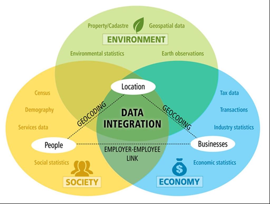
UN-GGIM: Europe Work Group on Data Integration. Facilitating the wider utilization of geospatial information to produce indicators
 UN-GGIM: Europe Work Group on Data Integration Facilitating the wider utilization of geospatial information to produce indicators IAEG SDG WG GI, Meeting 06-08.12.2018, NY Copyright 2013 EuroGeographics
The European Forum for Geospatial Statistics Benefits and challenges of INSPIRE in the field of statistics
 INSPIRE Conference 2016 Barcelona, Spain 26th 30th September 2016 The European Forum for Geospatial Statistics Benefits and challenges of INSPIRE in the field of statistics Janusz Dygaszewicz EFGS President
Measuring and Monitoring SDGs in Portugal: Ratio of land consumption rate to population growth rate Mountain Green Cover Index
 Measuring and Monitoring SDGs in Portugal: 11.3.1Ratio of land consumption rate to population growth rate 15.4.2 Mountain Green Cover Index United Nations World Geospatial Information Congress João David
Developing a global, people-based definition of cities and settlements
 Developing a global, people-based definition of cities and settlements Cooperation between: Directorate General for Regional and, Joint Research Centre, EUROSTAT (European Commission, European Union) OECD,
Work Group A «Core Data» Report and Update François Chirié, Dominique Laurent, France
 JOINT UN-GGIM: EUROPE ESS MEETING ON THE INTEGRATION OF STATISTICAL AND GEOSPATIAL INFORMATION LUXEMBOURG 11 MARCH 2016 Work Group A «Core Data» Report and Update François Chirié, Dominique Laurent, France
Progress of UN-GGIM: Europe Working Group A on Core Data
 PolicyKEN Budapest 29 November 2016 Progress of UN-GGIM: Europe Working Group A on Core Data François Chirié, Dominique Laurent, IGNF Core data context Background and purpose Aim of Work Group A to propose
IAEG SDGs WG GI, , Mexico City
 IAEG SDGs WG GI, 12-14.12.2016, Mexico City UN-GGIM:Europe s perspective and activities to support better integration of geospatial information and statistics and the UN SDG monitoring Pier-Giorgio Zaccheddu,
Esri s Living Atlas of the World Community Maps
 Esri s Living Atlas of the World Community Maps Seth Sarakaitis Wednesday May 7, 2014 ArcGIS Living Atlas Concept Living Atlas Content Tour Contributing to the Living Atlas (Community Maps) Seth Sarakaitis
INDICATOR Ratio of land consumption rate to population growth rate
 UN-GGIM: Europe Work Group on Data Integration subgroup 2 The territorial dimension in SDG indicators: the contribution of geospatial data and analysis sand its combination with statistical data INDICATOR
Sustainable Development Goals UN-GGIM Task Team
 Sustainable Development Goals UN-GGIM Task Team Executive Committee Meeting, 1. June 2016 Kristian Møller Copyright 2013 EuroGeographics Developments Creation of the One pager and matrix Reviewed by UN-GGIM:
Compact guides GISCO. Geographic information system of the Commission
 Compact guides GISCO Geographic information system of the Commission What is GISCO? GISCO, the Geographic Information System of the COmmission, is a permanent service of Eurostat that fulfils the requirements
Integration for Informed Decision Making
 Geospatial and Statistics Policy Intervention: Integration for Informed Decision Making Greg Scott Global Geospatial Information Management United Nations Statistics Division Department of Economic and
Integrating geography and statistics, but what about earth observation?
 Integrating geography and statistics, but what about earth observation? 8 0 0 y 2 2 3 0 9 x 6 3 9 1 9 n 1 8 3 7 3 9 7 2 2 4 8 8 7 8 4 7 5 Ola Nordbeck Senior Advisor Ola.nordbeck@spacecentre.no Bridging
The challenge of linking or integrating data on Buildings
 The challenge of linking or integrating data on Buildings Expected benefits: user requirements Wide use of data on Buildings Buildings are places where people live, work, spend more of their time => Data
Progress of UN-GGIM: Europe Working Group A on Core Data
 INSPIRE KEN 13 December 2016 Progress of UN-GGIM: Europe Working Group A on Core Data François Chirié, Dominique Laurent, IGN France Plan Introduction Objectives of the working group with respect to INSPIRE
Swedish Spatial Data Infrastructure and the National Geodata Strategy
 Submitted to the United Nations Committee of Experts on Global Geospatial Information Management Seventh Session New York, August 2018 Registration number 519-2018/4327 Country Report, Sweden Swedish Spatial
Geocoding of Statistics Portugal Business Register and it s integration with the INSPIRE s Annex III Buildings theme
 Geocoding of Statistics Portugal Business Register and it s integration with the INSPIRE s Annex III Buildings theme Barcelona, 26th September2016 INE/DMSI-GEO» 1 The summary Business Register (BR) Enterprise
ESDIN Results from a Crossborder INSPIRE Preparatory Project. Jörgen Hartnor, Lantmäteriet.
 ESDIN Results from a Crossborder INSPIRE Preparatory Project Jörgen Hartnor, Lantmäteriet www.esdin.eu Ett econtentplus Best Practice Network projekt September 2008 February 2011 Coordinated by EuroGeographics
8 th Meeting of IAEG-SDGs 5 8 November 2018, Stockholm, Sweden. Meetings. Report
 Meetings 8 th Meeting of IAEG-SDGs Between April 2018 and November 2018, the Working Group on Geospatial Information of the IAEG- SDGs held two online meetings; presented a report to the United Nations
How the science of cities can help European policy makers: new analysis and perspectives
 How the science of cities can help European policy makers: new analysis and perspectives By Lewis Dijkstra, PhD Deputy Head of the Economic Analysis Unit, DG Regional and European Commission Overview Data
USING DOWNSCALED POPULATION IN LOCAL DATA GENERATION
 USING DOWNSCALED POPULATION IN LOCAL DATA GENERATION A COUNTRY-LEVEL EXAMINATION CONTENT Research Context and Approach. This part outlines the background to and methodology of the examination of downscaled
Improving rural statistics. Defining rural territories and key indicators of rural development
 Improving rural statistics Defining rural territories and key indicators of rural development Improving rural statistics Improving Rural Statistics In 2016, the Global Strategy to improve Agricultural
Use of registers in statistical geospatial integration
 Use of registers in statistical geospatial integration Trevor Sutton Deputy Australian Statistician Statistical Business Transformation Australian Bureau of Statistics March 2016 Role of registers in the
CES Seminar 2016: Geospatial information services based on official statistics Key issues from the session II papers
 Norbert Rainer 64 th plenary session of the Conference of European Statisticians 28 April 2016, Paris CES Seminar 2016: Geospatial information services based on official statistics Key issues from the
Integrating Official Statistics and Geospatial Information NBS Experience
 Integrating Official Statistics and Geospatial Information NBS Experience Presented by Eng. Reda AL Sabbagh Director of IT Dept. Prepared by Eng. Adham Makky GIS Specialist Topics to be covered: Background
Qatar Statistical Geospatial Integration
 Qatar Statistical Geospatial Integration A Presentation by the Ministry of Development Planning & Statistics (MDPS), State of Qatar http://www.mdps.gov.qa (Fourth UN-GGIM Arab States Committee Meeting,
Module 3 Indicator Land Consumption Rate to Population Growth Rate
 Regional Training Workshop on Human Settlement Indicators Module 3 Indicator 11.3.1 Land Consumption Rate to Population Growth Rate Dennis Mwaniki Global Urban Observatory, Research and Capacity Development
Land Accounts - The Canadian Experience
 Land Accounts - The Canadian Experience Development of a Geospatial database to measure the effect of human activity on the environment Who is doing Land Accounts Statistics Canada (national) Component
Case study: Nairobi City County CBD and its Environs. Presenter: Peter Patrick Kioko. Supervisor: Mr. B.M. Okumu
 Case study: Nairobi City County CBD and its Environs Presenter: Peter Patrick Kioko Supervisor: Mr. B.M. Okumu OUTLINE Introduction Problem Statement Objectives Area of study Application of GIS Methodology
European Forum for Geography & Statistics Conference 2018
 European Forum for Geography & Statistics Conference 2018 Welcome speech Dr. Janusz Dygaszewicz EFGS President Director of ICT Systems, Geostatistics and Census Department Statistics Poland Helsinki, Finland,
Fundamental Geospatial Datasets in Africa. Andre Nonguierma New York, 03 August 2015
 Fundamental Geospatial Datasets in Africa United Nations Economic Commission for Africa Geoinformation & Spatial Statistics Andre Nonguierma New York, 03 August 2015 Core Data : Lack of consistency Infrastructure
The Global Fundamental Geospatial Data Themes Journey. April Clare Hadley WG Chair
 The Global Fundamental Geospatial Data Themes Journey April 2018 Clare Hadley WG Chair The Road to here Why Global? Why Geospatial? Why Fundamental? Why Themes? The route we took Where does the road go
The Global Statistical Geospatial Framework and the Global Fundamental Geospatial Themes
 The Global Statistical Geospatial Framework and the Global Fundamental Geospatial Themes Sub-regional workshop on integration of administrative data, big data and geospatial information for the compilation
Earth Observation for Sustainable Development to Support Land Use Planning in Urban Areas
 Background Image Source bbc.co.uk Human Planet 2011 BBC Earth Observation for Sustainable Development to Support Land Use Planning in Urban Areas Thomas Häusler, Sharon Gomez, Fabian Enssle GAF AG Land
Preparation of Database for Urban Development
 Preparation of Database for Urban Development By PunyaP OLI, 1. Chairman, ERMC (P) Ltd., Kathmandu, Nepal. Email: punyaoli@ermcnepal.com 2. Coordinator, Himalayan College of Geomatic Engineering and Land
The UN-GGIM: Europe core data initiative to encourage Geographic information supporting Sustainable Development Goals Dominique Laurent, France
 INSPIRE conference Strasbourg 6 September 2017 The UN-GGIM: Europe core data initiative to encourage Geographic information supporting Sustainable Development Goals Dominique Laurent, France Introduction
Report on the establishment of UN GGIM: Europe Item 14. 4th session of the Committee of Experts on UN-GGIM
 Report on the establishment of UN GGIM: Europe Item 14 1 Why regional European committees of UN GGIM? In the ECOSOC resolution 2011/24 on the UN GGIM: Emphasizes the importance of promoting national, regional
Adding value to Copernicus services with member states reference data
 www.eurogeographics.org Adding value to Copernicus services with member states reference data Neil Sutherland neil.sutherland@os.uk GIS in the EU 10 November 2016 Copyright 2016 EuroGeographics 61 member
The Geospatial Information Management (GIM) INSPIRE Data Specification and COPERNICUS In situ data
 INSPIRE Data Specification and COPERNICUS In situ data") INSPIRE conference Barcelona 29 September 2016 INSPIRing a sustainable environment The Geospatial Information Management (GIM) INSPIRE Data Specification and COPERNICUS In situ data Antonio Arozarena,
INSPIRE conference Barcelona 29 September 2016 INSPIRing a sustainable environment The Geospatial Information Management (GIM) INSPIRE Data Specification and COPERNICUS In situ data Antonio Arozarena,
Open Data meets Big Data
 Open Data meets Big Data Max Craglia, Sven Schade, Anders Friis European Commission Joint Research Centre www.jrc.ec.europa.eu Serving society Stimulating innovation Supporting legislation JRC is Technical
Economic and Social Council
 United Nations Economic and Social Council Distr.: General 18 July 2016 Original: English Committee of Experts on Global Geospatial Information Management Sixth session New York, 3-5 August 2016 Item 2
Demystifying ArcGIS Online. Karen Lizcano Esri
 Demystifying ArcGIS Online Karen Lizcano Esri An Integrated Web GIS Platform Desktop Web Device Powered by Services Managed via Portal Access from any Device Portal Server Online Content and Services ArcGIS
Core Spatial Data Theme Buildings Recommendation for Content. Working Group A - Deliverable of Task 1.b. Version
 Core Spatial Data Theme Buildings Recommendation for Content Working Group A - Deliverable of Task 1.b Version 1.0-2018-06-01 1 Version History Version number Date Modified by Comments 1.0 2018-06-01 Dominique
Sharthi Laldaparsad Statistics South Africa, Policy Research & Analysis. Sub-regional workshop on integration of administrative data,
 Sub-regional workshop on integration of administrative data, big data and geospatial information for the compilation of SDG indicators and International Workshop on Global Fundamental Geospatial Data Themes
APPLYING URBAN COMPACTNESS METRICS ON PAN-EUROPEAN DATASETS
 APPLYING URBAN COMPACTNESS METRICS ON PAN-EUROPEAN DATASETS D. Stathakis a, *, G. Tsilimigkas b a University or Thessaly, Department of Planning and Regional Development, Pedion Areos, 38334, Volos, Hellenic
European Forum for Geography and Statistics Vienna Conference Vienna, November 2015 Name (s) of author(s) IT Geostat Population Grid 2011
 of author(s) IT Geostat Population Grid 2011") European Forum for Geography and Statistics Vienna Conference Vienna, 10 12 November 2015 Name (s) of author(s) (1) Raffaella Chiocchini (1) Stefano Mugnoli (2) Luca Congedo (2) Michele Munafò Organization
European Forum for Geography and Statistics Vienna Conference Vienna, 10 12 November 2015 Name (s) of author(s) (1) Raffaella Chiocchini (1) Stefano Mugnoli (2) Luca Congedo (2) Michele Munafò Organization
Workshop on Global Fundamental Geospatial Data Themes
 Workshop on Global Fundamental Geospatial Data Themes June 2018 Objectives of the Workshop Introduce you to the work and outputs of the Fundamental Data WG (FDWG) Consider how the themes apply to SDGs
a national geological survey perspective François ROBIDA BRGM (French Geological Survey)
") a national geological survey perspective François ROBIDA BRGM (French Geological Survey) Pre-Conference Seminar on Socio-Economic Value of Geospatial for National and Regional Development 21 August 2017,
a national geological survey perspective François ROBIDA BRGM (French Geological Survey) Pre-Conference Seminar on Socio-Economic Value of Geospatial for National and Regional Development 21 August 2017,
ADDRESSING THE DATA AND INFORMATION NEEDS FOR GOOD GOVERNANCE, SHARING EXPERIENCES FROM COTE D IVOIRE. 20 April 2016 to 22 April 2016 ADDIS ABABA
 20 April 2016 to 22 April 2016 ADDIS ABABA ADDRESSING THE DATA AND INFORMATION NEEDS FOR GOOD GOVERNANCE, SHARING EXPERIENCES FROM COTE D IVOIRE Dr. Edouard FONH-GBEI Director General of CNTIG, General
RESULTS OF DEVELOPMENT AND APPLICATION GEOGRAPHIC INFORMATION STANDARDS IN VIETNAM. Dr. Tran Bach Giang Vietnam
 RESULTS OF DEVELOPMENT AND APPLICATION GEOGRAPHIC INFORMATION STANDARDS IN VIETNAM Dr. Tran Bach Giang Vietnam Shibu lijack Contents 1. BACKGROUND 2. BASIC GEOGRAPHIC INFORMATION STANDARDS (BGIS) Background
INSPIRE in the context of EC Directive 2002/49/EC on Environmental Noise
 INSPIRE in the context of EC Directive 2002/49/EC on Environmental Noise Simon Shilton Acustica Ltd, United Kingdom Nigel Jones Extrium Ltd, United Kingdom About the Authors www.acustica.co.uk Acoustics
Earth Observation & GeoSpatial Information for Monitoring Urban SDG Indicators. Global Urbanization Trend
 Earth Observation & GeoSpatial Information for Monitoring Urban SDG Indicators Yifang Ban, Professor Director, Division of Geoinformatics Vice Chair, Department for Urban Planning and Environment KTH Royal
Remote Sensing the Urban Landscape
 Remote Sensing the Urban Landscape Urban landscape are composed of a diverse assemblage of materials (concrete, asphalt, metal, plastic, shingles, glass, water, grass, shrubbery, trees, and soil) arranged
MANUAL ON THE BSES: LAND USE/LAND COVER
 6. Environment Protection, Management and Engagement 2. Environmental Resources and their Use 5. Human Habitat and Environmental Health 1. Environmental Conditions and Quality 4. Disasters and Extreme
Brazil Experience in SDG data production, dissemination and capacity building
 Brazil Experience in SDG data production, dissemination and capacity building Claudio Stenner Coordinator of Geography 4th Meeting of the Working Group on Geospatial Information IAEG-SDG United Nations
Copernicus Land HRL Imperviousness: 2012 dataset, indicator Title
 Copernicus Land HRL Imperviousness: 2012 dataset, 06-09 indicator and outlook Title 2015+ Tobias LANGANKE First name SURNAME Project manager, Copernicus Position land services Name European of the Environment
Report of the United Kingdom Division
 UNITED NATIONS GROUP OF EXPERTS WORKING PAPER ON GEOGRAPHICAL NAMES NO. 41/4 Twenty-ninth session Bangkok, Thailand, 25 29 April 2016 Item 4 of the Provisional Agenda Report of the Divisions Report of
Towards indicators of proximity to services in Europe's major cities
 Towards indicators of proximity to services in Europe's major cities Enhancing the analytical use of the GMES Urban Atlas in combination with population distribution data Hugo Poelman European Commission
Ministry of ICT of I.R.IRAN
 The ECO 8/6 mill km 2 10 Slamic countries ~330 mill people Oil, Gas, Industries,Tourism 2 Issue transformation in last decade Problem solving needs more integrated approach More interaction &complexity
Preparing the GEOGRAPHY for the 2011 Population Census of South Africa
 Preparing the GEOGRAPHY for the 2011 Population Census of South Africa Sharthi Laldaparsad Statistics South Africa; E-mail: sharthil@statssa.gov.za Abstract: Statistics South Africa (Stats SA) s Geography
Achieving the Vision Geo-statistical integration addressing South Africa s Developmental Agenda. geospatial + statistics. The Data Revolution
 Achieving the Vision Geo-statistical integration addressing South Africa s Developmental Agenda geospatial + statistics The Data Revolution humble beginnings, present & future - South Africa UN World Data
High Resolution Land Use Information by combined Analysis of Digital Landscape Models and Statistical Data Sets. Tobias Krüger Gotthard Meinel
 High Resolution Land Use Information by combined Analysis of Digital Landscape Models and Statistical Data Sets Tobias Krüger Gotthard Meinel Agenda Monitoring approach Input Data Data Processing Output
Comparing CORINE Land Cover with a more detailed database in Arezzo (Italy).
.") Comparing CORINE Land Cover with a more detailed database in Arezzo (Italy). Javier Gallego JRC, I-21020 Ispra (Varese) ITALY e-mail: javier.gallego@jrc.it Keywords: land cover, accuracy assessment, area
Comparing CORINE Land Cover with a more detailed database in Arezzo (Italy). Javier Gallego JRC, I-21020 Ispra (Varese) ITALY e-mail: javier.gallego@jrc.it Keywords: land cover, accuracy assessment, area
EuroGeographics & INSPIRE. Nick Land, Executive Director of EuroGeographics
 EuroGeographics & INSPIRE Nick Land, Executive Director of EuroGeographics EuroGeographics A growing association 49 Members, 42 countries Topographic mapping, cadastre, land registry + Networked organisation
Digitization in a Census
 Topics Connectivity of Geographic Data Sketch Maps Data Organization and Geodatabases Managing a Digitization Project Quality and Control Topology Metadata 1 Topics (continued) Interactive Selection Snapping
City definitions. Sara Ben Amer. PhD Student Climate Change and Sustainable Development Group Systems Analysis Division
 City definitions Sara Ben Amer PhD Student Climate Change and Sustainable Development Group Systems Analysis Division sbea@dtu.dk Contents 1. Concept of a city 2. Need for the city definition? 3. Challenges
Country Report on SDI Activities in Singapore *
 UNITED NATIONS E/CONF.100/CRP.9 ECONOMIC AND SOCIAL COUNCIL Eighteenth United Nations Regional Cartographic Conference for Asia and the Pacific Bangkok, 26-29 October 2009 Item 7(a) of the provisional
Illustrator: Vector base Each line/point store some sort of information Mapping Representation of the world
 Illustrator: Vector base Each line/point store some sort of information Mapping Representation of the world Photoshop Raster base Images can be overlaid Pixel vector data model: [data models] A representation
SDI Development in Georgia. Mari Khardziani Head of International Relations Unit National Agency of Public Registry
 SDI Development in Georgia Mari Khardziani Head of International Relations Unit National Agency of Public Registry Kehl, Germany September 5, 2017 2 National Agency of Public Registry Legal Entity of Public
Indicator : Average share of the built-up area of cities that is open space for public use for all, by sex, age and persons with disabilities
 Goal 11: Make cities and human settlements inclusive, safe, resilient and sustainable Target 11.7: By 2030, provide universal access to safe, inclusive and accessible, green and public spaces, in particular
Applied spatial data for sustainable development strategy in Germany
 Applied spatial data for sustainable development strategy in Germany Stephan Arnold Areal Statistics, Federal Statistical Office, Germany Federal Statistical Office Headquarter: Wiesbaden Branch Office:
TheEuropean Location Framework
 TheEuropean Location Framework Presentation to: Author: Date: TN-ITS/INSPIRE session at INSPIRE Conference Olaf Magnus Østensen, ELF co-ordinator 18 June2014 The ELF project 15 national mapping authorities
INSPIRE Thematic Cluster on Topographic and Cadastral Reference data
 INSPIRE Thematic Cluster on Topographic and Cadastral Reference data Anja Hopfstock - facilitator www.jrc.ec.europa.eu Serving society Stimulating innovation Supporting legislation Status of Thematic cluster
INSPIRE in Sweden.
 INSPIRE in Sweden Swedish National Data Service Established 2008. SND is a service organisation for Swedish research within the Humanities, Social Sciences and Medicine. SND is the Swedish node in an international
Joint Research Centre (JRC)
") Joint Research Centre (JRC) IPSC - Institute for the Protection and Security of the Citizen SES - Support to External Security Unit Ispra Italy http://isferea.jrc.ec.europa.eu/ http://www.jrc.ec.europa.eu/
Joint Research Centre (JRC) IPSC - Institute for the Protection and Security of the Citizen SES - Support to External Security Unit Ispra Italy http://isferea.jrc.ec.europa.eu/ http://www.jrc.ec.europa.eu/
UN-GGIM & UN SDGs - better integration of geospatial information and statistics to support the UN SDG monitoring
 UN-GGIM & UN SDGs - better integration of geospatial information and statistics to support the UN SDG monitoring Pier-Giorgio Zaccheddu, International affairs @ BKG Content Connecting geospatial and statistical
Investigation of the Effect of Transportation Network on Urban Growth by Using Satellite Images and Geographic Information Systems
 Presented at the FIG Congress 2018, May 6-11, 2018 in Istanbul, Turkey Investigation of the Effect of Transportation Network on Urban Growth by Using Satellite Images and Geographic Information Systems
Geoscape Capturing Australia s Built Environment for emergency modelling and management. Dan Paull Chief Executive Officer PSMA Australia
 Geoscape Capturing Australia s Built Environment for emergency modelling and management Dan Paull Chief Executive Officer PSMA Australia There is no wealth like knowledge, and no poverty like ignorance.
INSPIREd solutions for Air Quality problems Alexander Kotsev
 INSPIREd solutions for Air Quality problems Alexander Kotsev www.jrc.ec.europa.eu Serving society Stimulating innovation Supporting legislation The European data puzzle The European data puzzle 24 official
Merging statistics and geospatial information
 Merging statistics and geospatial information Demography / Commuting / Spatial planning / Registers Mirosław Migacz Chief GIS Specialist Janusz Dygaszewicz Director Central Statistical Office of Poland
Influence of INSPIRE on European/national data specifications
 www.eurogeographics.org Influence of INSPIRE on European/national data specifications Saulius Urbanas, EuroGeographics 20 th June 2017 Copyright 2013 EuroGeographics EuroGeographics 46 European countries
CARTOGRAPHIC INFORMATION MANAGEMENT IN COLOMBIA REACH A LEVEL OF PERFECTION
 CARTOGRAPHIC INFORMATION MANAGEMENT IN COLOMBIA REACH A LEVEL OF PERFECTION Jaime Alberto Duarte Castro 1 Carrera 30 No. 48 51 Bogotá - Colombia, jduarte@igac.gov.co Claudia Inés Sepúlveda Fajardo 2 Carrera
Spatial metrics for Greek cities using land cover information from the Urban Atlas
 Spatial metrics for Greek cities using land cover information from the Urban Atlas Poulicos Prastacos IACM-FORTH P.O. Box 1385 Heraklion, Greece poulicos@iacm.forth.gr Nektarios Chrysoulakis IACM-FORTH
Egypt Public DSS. the right of access to information. Mohamed Ramadan, Ph.D. [R&D Advisor to the president of CAPMAS]
![Egypt Public DSS. the right of access to information. Mohamed Ramadan, Ph.D. [R&D Advisor to the president of CAPMAS]](/thumbs/89/98483713.jpg "Egypt Public DSS. the right of access to information. Mohamed Ramadan, Ph.D. [R&D Advisor to the president of CAPMAS]") Egypt Public DSS ì the right of access to information Central Agency for Public Mobilization and Statistics Arab Republic of Egypt Mohamed Ramadan, Ph.D. [R&D Advisor to the president of CAPMAS] Egypt
Egypt Public DSS ì the right of access to information Central Agency for Public Mobilization and Statistics Arab Republic of Egypt Mohamed Ramadan, Ph.D. [R&D Advisor to the president of CAPMAS] Egypt
European Location Framework data in the ArcGIS platform
 European Location Framework data in the ArcGIS platform Presentation to: Author: Date: INSPIRE Conference 2016 Clemens Portele 26 September 2016 Why ELF? Global (e.g. UN GGIM) Regional Europe (INSPIRE
Second Administrative Level Boundaries (SALB) initiative & geographic names in cartography. Geospatial Information Section
 initiative & geographic names in cartography. Geospatial Information Section") Second Administrative Level Boundaries (SALB) initiative & geographic names in cartography Geospatial Information Section Introduction Goals Global agenda How does SALB work? Latest News on geographic
Second Administrative Level Boundaries (SALB) initiative & geographic names in cartography Geospatial Information Section Introduction Goals Global agenda How does SALB work? Latest News on geographic
GROUP ON INTEGRATION OF STATISTICAL AND GEOSPATIAL INFORMATION GT-IIEG
 UN-GGIM: Americas WORKING GROUP ON INTEGRATION OF STATISTICAL AND GEOSPATIAL INFORMATION GT-IIEG Bogotá, Colombia August, 2018 www.dane.gov.co Working group GT-IIEG Objective: To raise awareness and promote
LAND COVER CHANGES IN ROMANIA BASED ON CORINE LAND COVER INVENTORY
 LAND COVER CHANGES IN ROMANIA BASED ON CORINE LAND COVER INVENTORY 1990 2012 JENICĂ HANGANU, ADRIAN CONSTANTINESCU * Key-words: CORINE Land Cover inventory, Land cover changes, GIS. Abstract. From 1990
Country Report On Sdi Activities In Singapore ( )
") UNITED NATIONS E/CONF.102/IP.4 ECONOMIC AND SOCIAL COUNCIL Nineteenth United Nations Regional Cartographic Conference for Asia and the Pacific Bangkok, 29 October 1 November 2012 Item 6(b) of the provisional
UNITED NATIONS E/CONF.102/IP.4 ECONOMIC AND SOCIAL COUNCIL Nineteenth United Nations Regional Cartographic Conference for Asia and the Pacific Bangkok, 29 October 1 November 2012 Item 6(b) of the provisional
INSPIRE Basics. Vlado Cetl European Commission Joint Research Centre. https://ec.europa.eu/jrc/
 INSPIRE Basics Vlado Cetl European Commission Joint Research Centre https://ec.europa.eu/jrc/ Serving society Stimulating innovation Supporting legislation Outline SDI? Why European SDI? INSPIRE Policy
SDI Implementation at the Local
 SDI Implementation at the Local Administration Level of Germany Hartmut Müller and Stephan von St. Vith FIG Working Week 2009 Surveyors Key Role in Accelerated Development, Eilat, Israel, 3-8 May 2009