Stephen W. Bieda III, Steven L. Mullen, Christopher L. Castro University of Arizona Department of Atmospheric Sciences
|
|
|
- Ruby Wiggins
- 5 years ago
- Views:
Transcription
1 Stephen W. Bieda III, Steven L. Mullen, Christopher L. Castro University of Arizona Department of Atmospheric Sciences
2 Collaborative effort between National Weather Service, Tucson, AZ WSFO and the University of Arizona Dept. of Atmospheric Sciences. To provide an overview of inverted troughs, which are important synoptic scale features related to monsoon rainfall. Continued work from Pytlak et al. (2005), and analysis conducted during These were also focused on during the NAME field campaign.

3 Source: NAME Science Plan 2004
4 Cyclonic circulation moving in a general westward direction across the NAME Tier I region. These are features in the middle and upper troposphere with maximum vorticity occurring above 500 mb, and are typically cold core in nature (i.e. 500mb temps below 6C). Source: NAME Science Operation Plan (2004)

5 Source: Pytlak et al. (2005)
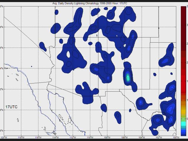
6 Time Frame: May 15 September 30 Years covered: Primary Datasets Used: North American Regional Reanalysis ( ): 3 hour time resolution Lightning Data, courtesy of VAISALA, Inc whose months were constrained to June 1 Sept 30 ( ): 1 hour time resolution Secondary Datasets Used: NOAA Daily Weather Maps ( ) SPC Upper Air and Surface Archive Datasets ( ) NAME data archives (2004 field campaign) Most of the datasets were used as a sanity check against NARR. Region covered: NARR boundaries were 10N 42N, 122W 90W (basically NAME Tier II). Lightning Data boundaries were 27.5N 40N, 120W 100W.
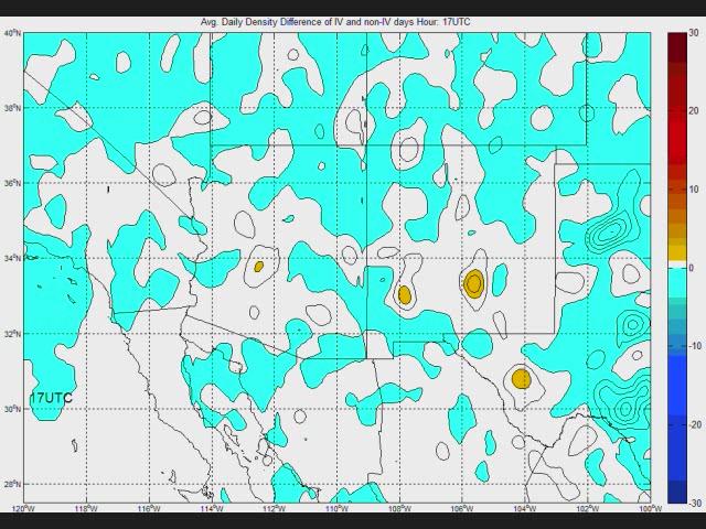
7 IV days for the lightning composite, days that an inverted trough passed north of 23N, and between 100W and 120W. CPVM Combined Pacific Variability Mode: uses the two (2) rotated EOFs of global SSTs which are associated with interannual and interdecadal variability in the tropical Pacific Ocean. Has a known relationship with NAMS variability at onset. (referenced in Castro et al. 2007, J. Climate)
8 Source: Castro et al. (2007)
9 Lightning composites for IV days and non IV days every hour were compared using a difference of means test for local significance and a field significance test (e.g. Livezey and Chen 1983). Track density composites for CPVM negative and positive years were compared using the same method as above. The lightning and Tier II regions considered.
10
11
")
12 This is an example, using Douglas and Englehart (2006) classification.
13 The primary mechanism for identifying the IV s will be through the use of the NARR s 250mb, 300mb, 500mb and 700mb heights, 500mb temperature and relative vorticity by way of identifying a distinguishable upper tropospheric (or lacking that, mid to lower tropospheric) center. Lacking any distinguishable center, relative vorticity will be used to help identify a region within the trough itself. Lacking the prior two, a discernible inverted trough in the easterlies (using the 500mb geopotential height 585 dm line or as close to that as possible). After applying the above methods, an equation using lat lon points was applied where 1 was the center, and a distance of 1 degree (approx. 4Δx of NARR) from the lat lon point was zero.

14 Jun 4 Jun 19 Jul 4 Jul 19 Aug 4 Aug 19

15 Jun 4 Jun 19 Jul 4 Jul 19 Aug 4 Aug 19

16 Jun 4 Jun 19 Jul 4 Jul 19 Aug 4 Aug 19
17 CPVM Positive CPVM Negative Years showing the same basic principle.
18 Inverted Troughs bring the necessary mechanisms (divergence aloft, instability, possible Gulf Surges) to enhance the diurnal cycle during the monsoon. The enhancement caused by these IVs are most pronounced and statistically significant during the hours of 18z 09z.
19 From the standpoint of diagnosing interannual variability, the CPVM is a powerful tool for forecasters in the NAM region. Transient IVs from a climatological standpoint track over central Mexico, and tend to reach a maximum just south of Baja California. During CPVM negative years, these tracks are either enhanced (+1 track/year) or deviated more northerly until around August (Julian Day 215). This enhances the rainfall in the core monsoon region.
20 Transient IVs are pronounced features of the NAMS that enhance the diurnal cycle and account for a large portion of the lightning activity over only a third of the days in the analysis period. From a long term standpoint, knowing what the CPVM index is will give a good sense of how many and where the IVs will track during the upcoming monsoon season. This year it worked very well as it was very wet in Tucson in July! I was also very OVERWORKED
21 Drs. Mullen and Castro for serving as my co Advisors and providing their expertise. Mr. Pytlak for his collaboration with this research. Dean Comrie for taking time out of his extremely busy schedule to provide input and serve on my committee. Dr. Cummins for allowing our group access to lightning data. Angel Otarola for helping me with MATLAB concerning NARR datasets.
22 Thank you for your time!
Use of the Combined Pacific Variability Mode for Climate Prediction in North America
 Use of the Combined Pacific Variability Mode for Climate Prediction in North America Christopher L. Castro,, Stephen Bieda III, and Francina Dominguez University of Arizona Regional Climate Forum for Northwest
Diagnosing the Climatology and Interannual Variability of North American Summer Climate with the Regional Atmospheric Modeling System (RAMS)
") Diagnosing the Climatology and Interannual Variability of North American Summer Climate with the Regional Atmospheric Modeling System (RAMS) Christopher L. Castro and Roger A. Pielke, Sr. Department of
Diagnosing the Climatology and Interannual Variability of North American Summer Climate with the Regional Atmospheric Modeling System (RAMS) Christopher L. Castro and Roger A. Pielke, Sr. Department of
On the Appropriateness of Spectral Nudging in Regional Climate Models
 On the Appropriateness of Spectral Nudging in Regional Climate Models Christopher L. Castro Department of Atmospheric Sciences University of Arizona Tucson, Arizona, USA Dynamically Downscaled IPCC model
Large Scale Influences on the North American Monsoon Variability and Potential for Improved Seasonal Predictability
 Large Scale Influences on the North American Monsoon Variability and Potential for Improved Seasonal Predictability Christopher L. Castro,, Stephen Bieda III, and Francina Dominguez University of Arizona
Sensitivity Analysis of WRF Forecasts in Arizona During the Monsoon Season Case Study: August 2, 2005 to August 3, 2005
 Sensitivity Analysis of WRF Forecasts in Arizona During the Monsoon Season Case Study: August 2, 2005 to August 3, 2005 Christopher L. Castro and Stephen Bieda III University of Arizona Susanne Grossman-Clarke
USE OF TOTAL COLUMN WATER VAPOR MEASUREMENTS FOR FORECASTS OF THE NORTH AMERICAN MONSOON PRECIPITATION
 USE OF TOTAL COLUMN WATER VAPOR MEASUREMENTS FOR FORECASTS OF THE NORTH AMERICAN MONSOON PRECIPITATION Presented by Yolande Serra University of Arizona Collaborators / Support Ave Arellano (UA Faculty)
Presentation Overview. Southwestern Climate: Past, present and future. Global Energy Balance. What is climate?
 Southwestern Climate: Past, present and future Mike Crimmins Climate Science Extension Specialist Dept. of Soil, Water, & Env. Science & Arizona Cooperative Extension The University of Arizona Presentation
Use of Emerging Applications of the Weather Research and Forecasting Model to Investigate the North American Monsoon
 Use of Emerging Applications of the Weather Research and Forecasting Model to Investigate the North American Monsoon Christopher L. Castro, Francina Dominguez, and Stephen Bieda III, Department of Atmospheric
The Relationship of Transient Upper-Level Troughs to Variability of the North American Monsoon System
 1AUGUST 2009 B I E D A E T A L. 4213 The Relationship of Transient Upper-Level Troughs to Variability of the North American Monsoon System STEPHEN W. BIEDA III, CHRISTOPHER L. CASTRO, AND STEVEN L. MULLEN
Investigation of the Summer Climate of North America: A Regional Atmospheric Modeling Study
 Los Mochis, Mexico. NAME Field Campaign. Summer 2004 Photo by Peter Rogers Investigation of the Summer Climate of North America: A Regional Atmospheric Modeling Study Christopher L. Castro Department of
El Niño, South American Monsoon, and Atlantic Niño links as detected by a. TOPEX/Jason Observations
 El Niño, South American Monsoon, and Atlantic Niño links as detected by a decade of QuikSCAT, TRMM and TOPEX/Jason Observations Rong Fu 1, Lei Huang 1, Hui Wang 2, Paola Arias 1 1 Jackson School of Geosciences,
Hurricanes and Tropical Weather Systems:
 Hurricanes and Tropical Weather Systems: An influence on weather in parts of the USA Meteorology 411 Iowa State University Week 2 Bill Gallus Classification/Terminology Tropical Disturbance enhanced convection
P2.4 THE IMPACT OF TROPICAL CYCLONE REMNANTS ON THE RAINFALL OF THE NORTH AMERICAN SOUTHWEST REGION
 P2.4 THE IMPACT OF TROPICAL CYCLONE REMNANTS ON THE RAINFALL OF THE NORTH AMERICAN SOUTHWEST REGION by Elizabeth A. Ritchie 1 and David Szenasi University of New Mexico 1. INTRODUCTION New Mexico has a
Seasonal Climate Watch June to October 2018
 Seasonal Climate Watch June to October 2018 Date issued: May 28, 2018 1. Overview The El Niño-Southern Oscillation (ENSO) has now moved into the neutral phase and is expected to rise towards an El Niño
The 2009 Hurricane Season Overview
 The 2009 Hurricane Season Overview Jae-Kyung Schemm Gerry Bell Climate Prediction Center NOAA/ NWS/ NCEP 1 Overview outline 1. Current status for the Atlantic, Eastern Pacific and Western Pacific basins
August Forecast Update for Atlantic Hurricane Activity in 2012
 August Forecast Update for Atlantic Hurricane Activity in 2012 Issued: 6 th August 2012 by Professor Mark Saunders and Dr Adam Lea Dept. of Space and Climate Physics, UCL (University College London), UK
Arizona Drought Monitoring Sensitivity and Verification Analyses Project Results and Future Directions
 Arizona Drought Monitoring Sensitivity and Verification Analyses Project Results and Future Directions A Water Sustainability Institute, Technology and Research Initiative Fund Project Christopher L. Castro,
Christopher L. Castro Department of Atmospheric Sciences University of Arizona
 Spatiotemporal Variability and Covariability of Temperature, Precipitation, Soil Moisture, and Vegetation in North America for Regional Climate Model Applications Christopher L. Castro Department of Atmospheric
The Unusual Behavior and Precipitation Pattern Associated with Tropical Storm Ignacio (1997)
") OCTOBER 2012 W O O D A N D R I T C H I E 3347 The Unusual Behavior and Precipitation Pattern Associated with Tropical Storm Ignacio (1997) KIMBERLY M. WOOD AND ELIZABETH A. RITCHIE Department of Atmospheric
OCTOBER 2012 W O O D A N D R I T C H I E 3347 The Unusual Behavior and Precipitation Pattern Associated with Tropical Storm Ignacio (1997) KIMBERLY M. WOOD AND ELIZABETH A. RITCHIE Department of Atmospheric
"STUDY ON THE VARIABILITY OF SOUTHWEST MONSOON RAINFALL AND TROPICAL CYCLONES FOR "
 "STUDY ON THE VARIABILITY OF SOUTHWEST MONSOON RAINFALL AND TROPICAL CYCLONES FOR 2001 2010" ESPERANZA O. CAYANAN, Ph.D. Chief, Climatology & Agrometeorology R & D Section Philippine Atmospheric Geophysical
The Relationship of the North American Monsoon to Tropical and North Pacific Sea Surface Temperatures as Revealed by Observational Analyses
 VOLUME 14 JOURNAL OF CLIMATE 15 DECEMBER 2001 The Relationship of the North American Monsoon to Tropical and North Pacific Sea Surface Temperatures as Revealed by Observational Analyses CHRISTOPHER L.
A 40-year climatology of extratropical transition in the eastern North Pacific continued (and some other stuff)
") GOES-EAST image of Hurricane Dora, 1445 UTC 21 July 2011 A 40-year climatology of extratropical transition in the eastern North Pacific continued (and some other stuff) Elizabeth A. Ritchie and Kimberly
GOES-EAST image of Hurricane Dora, 1445 UTC 21 July 2011 A 40-year climatology of extratropical transition in the eastern North Pacific continued (and some other stuff) Elizabeth A. Ritchie and Kimberly
Relationships Between Gulf of California Moisture Surges and Precipitation in the Southwestern United States
 Relationships Between Gulf of California Moisture Surges and Precipitation in the Southwestern United States by R. W. Higgins, W. Shi and C. Hain Climate Prediction Center, NOAA/NWS/NCEP February 2004
Seasonal Climate Watch July to November 2018
 Seasonal Climate Watch July to November 2018 Date issued: Jun 25, 2018 1. Overview The El Niño-Southern Oscillation (ENSO) is now in a neutral phase and is expected to rise towards an El Niño phase through
7 December 2016 Tokyo Climate Center, Japan Meteorological Agency
 Summary of the 2016 Asian Summer Monsoon 7 December 2016 Tokyo Climate Center, Japan Meteorological Agency This report summarizes the characteristics of the surface climate and atmospheric/oceanographic
UPDATE OF REGIONAL WEATHER AND SMOKE HAZE (December 2017)
") UPDATE OF REGIONAL WEATHER AND SMOKE HAZE (December 2017) 1. Review of Regional Weather Conditions for November 2017 1.1 In November 2017, Southeast Asia experienced inter-monsoon conditions in the first
UPDATE OF REGIONAL WEATHER AND SMOKE HAZE (December 2017) 1. Review of Regional Weather Conditions for November 2017 1.1 In November 2017, Southeast Asia experienced inter-monsoon conditions in the first
Tropical Waves. John Cangialosi and Lixion Avila National Hurricane Center. WMO Region IV Tropical Cyclone Workshop
 Tropical Waves John Cangialosi and Lixion Avila National Hurricane Center WMO Region IV Tropical Cyclone Workshop Outline Basic definition Schematic diagrams/interactions Operational products/forecasts
1. Introduction. 2. Verification of the 2010 forecasts. Research Brief 2011/ February 2011
 Research Brief 2011/01 Verification of Forecasts of Tropical Cyclone Activity over the Western North Pacific and Number of Tropical Cyclones Making Landfall in South China and the Korea and Japan region
Prospects for subseasonal forecast of Tropical Cyclone statistics with the CFS
 Prospects for subseasonal forecast of Tropical Cyclone statistics with the CFS Augustin Vintzileos (1)(3), Tim Marchok (2), Hua-Lu Pan (3) and Stephen J. Lord (1) SAIC (2) GFDL (3) EMC/NCEP/NOAA During
Frequency Modes of Monsoon Precipitation in Arizona and New Mexico
 3774 M O N T H L Y W E A T H E R R E V I E W VOLUME 134 Frequency Modes of Monsoon Precipitation in Arizona and New Mexico ANNE W. NOLIN Department of Geosciences, Oregon State University, Corvallis, Oregon
1. INTRODUCTION 2. AIRCRAFT OPERATIONS. 2.1 The objectives
 J5.8 MEAN STRUCTURE AND VARIABILITY OF THE LOW-LEVEL JET ACROSS THE CENTRAL GULF OF CALIFORNIA FROM NOAA WP-3D FLIGHT LEVEL OBSERVATIONS DURING THE NORTH AMERICAN MONSOON EXPERIMENT John F. Mejia, CIMMS/Univ.
Christopher L. Castro Department of Atmospheric Sciences University of Arizona Tucson, Arizona, USA
 Creating dynamically downscaled seasonal climate forecast and climate projection information for the North American Monsoon region suitable for decision making purposes Christopher L. Castro Department
PRMS WHITE PAPER 2014 NORTH ATLANTIC HURRICANE SEASON OUTLOOK. June RMS Event Response
 PRMS WHITE PAPER 2014 NORTH ATLANTIC HURRICANE SEASON OUTLOOK June 2014 - RMS Event Response 2014 SEASON OUTLOOK The 2013 North Atlantic hurricane season saw the fewest hurricanes in the Atlantic Basin
The Maritime Continent as a Prediction Barrier
 The Maritime Continent as a Prediction Barrier for the MJO Augustin Vintzileos EMC/NCEP SAIC Points to take back home. Forecast of the MJO is at, average, skillful for lead times of up to circa 2 weeks.
Understanding the Global Distribution of Monsoon Depressions
 DISTRIBUTION STATEMENT A. Approved for public release; distribution is unlimited. Understanding the Global Distribution of Monsoon Depressions William R. Boos PO Box 208109 New Haven, CT 06520 phone: (203)
Primary Factors Contributing to Japan's Extremely Hot Summer of 2010
 temperature anomalies by its standard deviation for JJA 2010 Primary Factors Contributing to Japan's Extremely Hot Summer of 2010 Nobuyuki Kayaba Climate Prediction Division,Japan Meteorological Agancy
Investigate the influence of the Amazon rainfall on westerly wind anomalies and the 2002 Atlantic Nino using QuikScat, Altimeter and TRMM data
 Investigate the influence of the Amazon rainfall on westerly wind anomalies and the 2002 Atlantic Nino using QuikScat, Altimeter and TRMM data Rong Fu 1, Mike Young 1, Hui Wang 2, Weiqing Han 3 1 School
Department of Atmospheric Science, Colorado State University, Fort Collins, Colorado
 3866 J O U R N A L O F C L I M A T E VOLUME 20 Investigation of the Summer Climate of the Contiguous United States and Mexico Using the Regional Atmospheric Modeling System (RAMS). Part II: Model Climate
Analysis of Fall Transition Season (Sept-Early Dec) Why has the weather been so violent?
 Why has the weather been so violent?") WEATHER TOPICS Analysis of Fall Transition Season (Sept-Early Dec) 2009 Why has the weather been so violent? As can be seen by the following forecast map, the Fall Transition and early Winter Season of
WEATHER TOPICS Analysis of Fall Transition Season (Sept-Early Dec) 2009 Why has the weather been so violent? As can be seen by the following forecast map, the Fall Transition and early Winter Season of
UPDATE OF REGIONAL WEATHER AND SMOKE HAZE (September 2017)
") UPDATE OF REGIONAL WEATHER AND SMOKE HAZE (September 2017) 1. Review of Regional Weather Conditions in August 2017 1.1 Southwest Monsoon conditions continued to prevail in the region in August 2017. The
UPDATE OF REGIONAL WEATHER AND SMOKE HAZE (September 2017) 1. Review of Regional Weather Conditions in August 2017 1.1 Southwest Monsoon conditions continued to prevail in the region in August 2017. The
Why There Is Weather?
 Lecture 6: Weather, Music Of Our Sphere Weather and Climate WEATHER The daily fluctuations in atmospheric conditions. The atmosphere on its own can produce weather. (From Understanding Weather & Climate)
16C.6 Genesis of Atlantic tropical storms from African Easterly Waves a comparison of two contrasting years
 16C.6 Genesis of Atlantic tropical storms from African Easterly Waves a comparison of two contrasting years Susanna Hopsch 1 Department of Earth and Atmospheric Sciences, University at Albany, Albany,
WEEKEND WEATHER OUTLOOK BELIZE, CENTRAL AMERICA
 WEEKEND WEATHER OUTLOOK BELIZE, CENTRAL AMERICA PERIOD: Friday, July 13 until Monday, July 16, 2012 DATE ISSUED: Friday, June 13, 2012, 9:00 am RFrutos SYNOPSIS: A weak pressure gradient over the NW Caribbean
Satellites, Weather and Climate Module??: Polar Vortex
 Satellites, Weather and Climate Module??: Polar Vortex SWAC Jan 2014 AKA Circumpolar Vortex Science or Hype? Will there be one this year? Today s objectives Pre and Post exams What is the Polar Vortex
Charles Jones ICESS University of California, Santa Barbara CA Outline
 The Influence of Tropical Variations on Wintertime Precipitation in California: Pineapple express, Extreme rainfall Events and Long-range Statistical Forecasts Charles Jones ICESS University of California,
AnuMS 2018 Atlantic Hurricane Season Forecast
 AnuMS 2018 Atlantic Hurricane Season Forecast Issued: April 10, 2018 by Dale C. S. Destin (follow @anumetservice) Director (Ag), Antigua and Barbuda Meteorological Service (ABMS) The *AnuMS (Antigua Met
August Forecast Update for Atlantic Hurricane Activity in 2015
 August Forecast Update for Atlantic Hurricane Activity in 2015 Issued: 5 th August 2015 by Professor Mark Saunders and Dr Adam Lea Dept. of Space and Climate Physics, UCL (University College London), UK
Seasonal Climate Watch April to August 2018
 Seasonal Climate Watch April to August 2018 Date issued: Mar 23, 2018 1. Overview The El Niño-Southern Oscillation (ENSO) is expected to weaken from a moderate La Niña phase to a neutral phase through
An upper to mid level circulation (Low) in the NW Caribbean is
 in the NW Caribbean is") WEEKLY WEATHER OUTLOOK BELIZE, CENTRAL AMERICA PERIOD: Monday-Monday, Oct. 1 October 8, 2012 DATE ISSUED: Monday, Oct 1, 2012 6:00 am RFrutos EcoSolutions & Services SYNOPSIS: An upper to mid level circulation
WEEKLY WEATHER OUTLOOK BELIZE, CENTRAL AMERICA PERIOD: Monday-Monday, Oct. 1 October 8, 2012 DATE ISSUED: Monday, Oct 1, 2012 6:00 am RFrutos EcoSolutions & Services SYNOPSIS: An upper to mid level circulation
On the presence of tropical vortices over the Southeast Asian Sea- Maritime Continent region
 Technical Conference of 50 th Annual Session of Typhoon Committee 2018 On the presence of tropical vortices over the Southeast Asian Sea- Maritime Continent region Nguyen Dang-Quang 1, James Renwick 2,
Weather and Climate Summary and Forecast Summer 2017
 Weather and Climate Summary and Forecast Summer 2017 Gregory V. Jones Southern Oregon University August 4, 2017 July largely held true to forecast, although it ended with the start of one of the most extreme
CPTEC and NCEP Model Forecast Drift and South America during the Southern Hemisphere Summer
 CPTEC and NCEP Model Forecast Drift and South America during the Southern Hemisphere Summer José Antonio Aravéquia 1 Pedro L. Silva Dias 2 (1) Center for Weather Forecasting and Climate Research National
Impacts of the April 2013 Mean trough over central North America
 Impacts of the April 2013 Mean trough over central North America By Richard H. Grumm National Weather Service State College, PA Abstract: The mean 500 hpa flow over North America featured a trough over
Supplemental Material
 Supplemental Material Journal of Climate Interannual Variation of the Summer Rainfall Center in the South China Sea https://doi.org/10.1175/jcli-d-16-0889.s1. Copyright 2017 American Meteorological Society
AnuMS 2018 Atlantic Hurricane Season Forecast
 AnuMS 2018 Atlantic Hurricane Season Forecast Issued: May 10, 2018 by Dale C. S. Destin (follow @anumetservice) Director (Ag), Antigua and Barbuda Meteorological Service (ABMS) The *AnuMS (Antigua Met
The feature of atmospheric circulation in the extremely warm winter 2006/2007
 The feature of atmospheric circulation in the extremely warm winter 2006/2007 Hiroshi Hasegawa 1, Yayoi Harada 1, Hiroshi Nakamigawa 1, Atsushi Goto 1 1 Climate Prediction Division, Japan Meteorological
2013 ATLANTIC HURRICANE SEASON OUTLOOK. June RMS Cat Response
 2013 ATLANTIC HURRICANE SEASON OUTLOOK June 2013 - RMS Cat Response Season Outlook At the start of the 2013 Atlantic hurricane season, which officially runs from June 1 to November 30, seasonal forecasts
Modeling rainfall diurnal variation of the North American monsoon core using different spatial resolutions
 Modeling rainfall diurnal variation of the North American monsoon core using different spatial resolutions Jialun Li, X. Gao, K.-L. Hsu, B. Imam, and S. Sorooshian Department of Civil and Environmental
COLORADO STATE UNIVERSITY FORECAST OF ATLANTIC HURRICANE ACTIVITY FROM AUGUST 4-17, 2015
 COLORADO STATE UNIVERSITY FORECAST OF ATLANTIC HURRICANE ACTIVITY FROM AUGUST 4-17, 2015 We expect that the next two weeks will be characterized by below-average amounts (
GPC Exeter forecast for winter Crown copyright Met Office
 GPC Exeter forecast for winter 2015-2016 Global Seasonal Forecast System version 5 (GloSea5) ensemble prediction system the source for Met Office monthly and seasonal forecasts uses a coupled model (atmosphere
Assessing Land Surface Albedo Bias in Models of Tropical Climate
 DISTRIBUTION STATEMENT A. Approved for public release; distribution is unlimited. Assessing Land Surface Albedo Bias in Models of Tropical Climate William R. Boos (PI) Yale University PO Box 208109 New
NOTES AND CORRESPONDENCE. Annual Variation of Surface Pressure on a High East Asian Mountain and Its Surrounding Low Areas
 AUGUST 1999 NOTES AND CORRESPONDENCE 2711 NOTES AND CORRESPONDENCE Annual Variation of Surface Pressure on a High East Asian Mountain and Its Surrounding Low Areas TSING-CHANG CHEN Atmospheric Science
Impact of Tropical Easterly Waves on the North American Monsoon
 1APRIL 2007 A D A M S A N D S TENSRUD 1219 Impact of Tropical Easterly Waves on the North American Monsoon JENNIFER L. ADAMS Cooperative Institute for Mesoscale Meteorological Studies, University of Oklahoma,
A Statistical-Dynamical Seasonal Forecast of US Landfalling TC Activity
 A Statistical-Dynamical Seasonal Forecast of US Landfalling TC Activity Johnny Chan and Samson K S Chiu Guy Carpenter Asia-Pacific Climate Impact Centre City University of Hong Kong Research sponsored
Seasonal associations between mid-tropospheric height patterns and precipitation in the western Great Basin, USA
 Seasonal associations between mid-tropospheric height patterns and precipitation in the western Great Basin, USA By: Paul A. Knapp Knapp, P.A. (1994) Seasonal associations between mid-tropospheric pressure
Observational Analysis of an Upper-Level Inverted Trough during the 2004 North American Monsoon Experiment
 3540 M O N T H L Y W E A T H E R R E V I E W VOLUME 138 Observational Analysis of an Upper-Level Inverted Trough during the 2004 North American Monsoon Experiment ZACHARY O. FINCH AND RICHARD H. JOHNSON
10.5 ATMOSPHERIC AND OCEANIC VARIABILITY ASSOCIATED WITH GROWING SEASON DROUGHTS AND PLUVIALS ON THE CANADIAN PRAIRIES
 10.5 ATMOSPHERIC AND OCEANIC VARIABILITY ASSOCIATED WITH GROWING SEASON DROUGHTS AND PLUVIALS ON THE CANADIAN PRAIRIES Amir Shabbar*, Barrie Bonsal and Kit Szeto Environment Canada, Toronto, Ontario, Canada
Characteristics of North American Summertime Rainfall with Emphasis on the Monsoon
 15 MARCH 2008 L I EBMANN ET AL. 1277 Characteristics of North American Summertime Rainfall with Emphasis on the Monsoon BRANT LIEBMANN Cooperative Institute for Research in Environmental Sciences, Climate
AnuMS 2018 Atlantic Hurricane Season Forecast
 AnuMS 2018 Atlantic Hurricane Season : August 12, 2018 by Dale C. S. Destin (follow @anumetservice) Director (Ag), Antigua and Barbuda Meteorological Service (ABMS) The *AnuMS (Antigua Met Service) is
2011 Atlantic Hurricane Activity and Outlooks A Climate/ Historical Perspective
 2011 Atlantic Hurricane Activity and Outlooks A Climate/ Historical Perspective Gerry Bell NOAA Lead Seasonal Hurricane Forecaster Climate Prediction Center/ NWS Related Publications: Bell and Chelliah
The Interdecadal Variation of the Western Pacific Subtropical High as Measured by 500 hpa Eddy Geopotential Height
 ATMOSPHERIC AND OCEANIC SCIENCE LETTERS, 2015, VOL. 8, NO. 6, 371 375 The Interdecadal Variation of the Western Pacific Subtropical High as Measured by 500 hpa Eddy Geopotential Height HUANG Yan-Yan and
JMA s Seasonal Prediction of South Asian Climate for Summer 2018
 JMA s Seasonal Prediction of South Asian Climate for Summer 2018 Atsushi Minami Tokyo Climate Center (TCC) Japan Meteorological Agency (JMA) Contents Outline of JMA s Seasonal Ensemble Prediction System
TROPICAL-EXTRATROPICAL INTERACTIONS
 Notes of the tutorial lectures for the Natural Sciences part by Alice Grimm Fourth lecture TROPICAL-EXTRATROPICAL INTERACTIONS Anomalous tropical SST Anomalous convection Anomalous latent heat source Anomalous
NATS 101 Section 13: Lecture 25. Weather Forecasting Part II
 NATS 101 Section 13: Lecture 25 Weather Forecasting Part II NWP s First Baby Steps: Mid-Twentieth Century It wasn t until the development of computers in the 1940s and 1950s that NWP could be even attempted.
MPACT OF EL-NINO ON SUMMER MONSOON RAINFALL OF PAKISTAN
 MPACT OF EL-NINO ON SUMMER MONSOON RAINFALL OF PAKISTAN Abdul Rashid 1 Abstract: El-Nino is the dominant mod of inter- annual climate variability on a planetary scale. Its impact is associated worldwide
Introduction to African weather
 Introduction to African weather Dr Caroline Bain Met Office, Exeter, UK Overview Convection and general circulation A tour around the seasons: West African Monsoon, AEWs, Short rains East Africa, Low-level
Early May Cut-off low and Mid-Atlantic rains
 Abstract: Early May Cut-off low and Mid-Atlantic rains By Richard H. Grumm National Weather Service State College, PA A deep 500 hpa cutoff developed in the southern Plains on 3 May 2013. It produced a
Relationships between Gulf of California Moisture Surges and Tropical Cyclones in the Eastern Pacific Basin
 VOLUME 18 J O U R N A L O F C L I M A T E 15 NOVEMBER 2005 Relationships between Gulf of California Moisture Surges and Tropical Cyclones in the Eastern Pacific Basin R. W. HIGGINS AND W. SHI NOAA/NWS/NCEP/Climate
AnuMS 2018 Atlantic Hurricane Season Forecast
 AnuMS 2018 Atlantic Hurricane Season Forecast : June 11, 2018 by Dale C. S. Destin (follow @anumetservice) Director (Ag), Antigua and Barbuda Meteorological Service (ABMS) The *AnuMS (Antigua Met Service)
YACT (Yet Another Climate Tool)? The SPI Explorer
? The SPI Explorer") YACT (Yet Another Climate Tool)? The SPI Explorer Mike Crimmins Assoc. Professor/Extension Specialist Dept. of Soil, Water, & Environmental Science The University of Arizona Yes, another climate tool for
YACT (Yet Another Climate Tool)? The SPI Explorer Mike Crimmins Assoc. Professor/Extension Specialist Dept. of Soil, Water, & Environmental Science The University of Arizona Yes, another climate tool for
Long-Term Changes in Rainfall over Eastern China and Large-Scale Atmospheric Circulation Associated with Recent Global Warming
 1544 J O U R N A L O F C L I M A T E VOLUME 23 Long-Term Changes in Rainfall over Eastern China and Large-Scale Atmospheric Circulation Associated with Recent Global Warming PING ZHAO National Meteorological
Understanding the Microphysical Properties of Developing Cloud Clusters During TCS-08
 Understanding the Microphysical Properties of Developing Cloud Clusters During TCS-08 PI: Elizabeth A. Ritchie Department of Atmospheric Sciences, University of Arizona Room 542, Physics-Atmospheric Sciences
THE ROLE PLAYED BY BLOCKING OVER THE NORTHERN HEMISPHERE ON HURRICANE KATRINA
 THE ROLE PLAYED BY BLOCKING OVER THE NORTHERN J P 3.51 HEMISPHERE ON HURRICANE KATRINA Yehia Hafez* University of Cairo, Giza, Egypt ABSTARCT On year 2005, there exist 28 tropical Atlantic storms and hurricanes
Divergence, Spin, and Tilt. Convergence and Divergence. Midlatitude Cyclones. Large-Scale Setting
 Midlatitude Cyclones Equator-to-pole temperature gradient tilts pressure surfaces and produces westerly jets in midlatitudes Waves in the jet induce divergence and convergence aloft, leading to surface
Climate System Monitoring
 Climate System Monitoring Climate Prediction Division of JMA iroshi asegawa (h_hasegawa@met.kishou.go.jp) 1 Contents What is the climate system? Purpose of climate system monitoring View points for monitoring
Tropical Cyclone Hyperactivity in the Eastern and Central Caribbean Sea During the 2005 Atlantic Hurricane Season
 Proceedings of the National Conference On Undergraduate Research (NCUR) 2006 The University of North Carolina at Asheville Asheville, North Carolina April 6 8, 2006 Tropical Cyclone Hyperactivity in the
Atmospheric circulation analysis for seasonal forecasting
 Training Seminar on Application of Seasonal Forecast GPV Data to Seasonal Forecast Products 18 21 January 2011 Tokyo, Japan Atmospheric circulation analysis for seasonal forecasting Shotaro Tanaka Climate
UPDATE OF REGIONAL WEATHER AND SMOKE HAZE (May 2017)
") UPDATE OF REGIONAL WEATHER AND SMOKE HAZE (May 2017) 1. Review of Regional Weather Conditions in April 2017 1.1 Inter monsoon conditions, characterised by afternoon showers and winds that are generally
UPDATE OF REGIONAL WEATHER AND SMOKE HAZE (May 2017) 1. Review of Regional Weather Conditions in April 2017 1.1 Inter monsoon conditions, characterised by afternoon showers and winds that are generally
Understanding the Global Distribution of Monsoon Depressions
 DISTRIBUTION STATEMENT A. Approved for public release; distribution is unlimited. Understanding the Global Distribution of Monsoon Depressions William R. Boos Yale University PO Box 208109 New Haven, CT
COLORADO STATE UNIVERSITY FORECAST OF ATLANTIC HURRICANE ACTIVITY FROM SEPTEMBER 15 SEPTEMBER 28, 2015
 COLORADO STATE UNIVERSITY FORECAST OF ATLANTIC HURRICANE ACTIVITY FROM SEPTEMBER 15 SEPTEMBER 28, 2015 We expect that the next two weeks will be characterized by below-average amounts (
Seasonal Shifts in the North American Monsoon
 1 MAY 2007 G R A N T Z E T A L. 1923 Seasonal Shifts in the North American Monsoon KATRINA GRANTZ Department of Civil, Environmental, and Architectural Engineering, and Center for Advanced Decision Support
Introduction of climate monitoring and analysis products for one-month forecast
 Introduction of climate monitoring and analysis products for one-month forecast TCC Training Seminar on One-month Forecast on 13 November 2018 10:30 11:00 1 Typical flow of making one-month forecast Observed
Tropical Cyclone Genesis: What we know, and what we don t!
 Tropical Cyclone Genesis: What we know, and what we don t! Allison Wing! NSF Postdoctoral Research Fellow! Lamont-Doherty Earth Observatory! Columbia University! Overview! Climatology! What We Know! Theories!
April Forecast Update for North Atlantic Hurricane Activity in 2019
 April Forecast Update for North Atlantic Hurricane Activity in 2019 Issued: 5 th April 2019 by Professor Mark Saunders and Dr Adam Lea Dept. of Space and Climate Physics, UCL (University College London),
Potentially Wet Wed-Fri
 Potentially Wet Wed-Fri August 18, 2014 Last Week s Lightning Trends TUE 8/12 WED 8/13 THU 8/14 FRI 8/15 t SAT 8/16 SUN 8/17 August 1-16 Precipitation Anomaly: 2013 VS. 2014 AUG 1-16, 2013 AUG 1-16, 2014
August Forecast Update for Atlantic Hurricane Activity in 2016
 August Forecast Update for Atlantic Hurricane Activity in 2016 Issued: 5 th August 2016 by Professor Mark Saunders and Dr Adam Lea Dept. of Space and Climate Physics, UCL (University College London), UK
COLORADO STATE UNIVERSITY FORECAST OF ATLANTIC HURRICANE ACTIVITY FROM AUGUST 18-31, 2017
 COLORADO STATE UNIVERSITY FORECAST OF ATLANTIC HURRICANE ACTIVITY FROM AUGUST 18-31, 2017 We expect that the next two weeks will be characterized by above-average amounts (>130%) of activity relative to
UPDATE OF REGIONAL WEATHER AND SMOKE HAZE FOR MAY 2015
 UPDATE OF REGIONAL WEATHER AND SMOKE HAZE FOR MAY 2015 1. Review of Regional Weather Conditions in April 2015 1.1 Inter-Monsoon conditions prevailed over the ASEAN region in April 2015. The gradual northward
Model Climatology of the North American Monsoon Onset Period during
 3892 JOURNAL OF CLIMATE Model Climatology of the North American Monsoon Onset Period during 1980 2001 J. XU Department of Hydrology and Water Resources, The University of Arizona, Tucson, Arizona X. GAO
Variability of West African Weather Systems. Chris Thorncroft Department of Atmospheric and Environmental Sciences University at Albany
 Variability of West African Weather Systems Chris Thorncroft Department of Atmospheric and Environmental Sciences University at Albany Variability of West African Weather Systems (1) Convectively Coupled