IMPROVING PREDICTION OF HEAVY RAINFALL WITH ELEVATED CONVECTION
|
|
|
- Tiffany McLaughlin
- 5 years ago
- Views:
Transcription
1 IMPROVING PREDICTION OF HEAVY RAINFALL WITH ELEVATED CONVECTION Patrick Market, University of Missouri Laurel McCoy, University of Missouri and NOAA/NWS, Portland, OR Chad Gravelle, CIMSS/SSEC University of Wisconsin, Madison, WI Charles Graves, Saint Louis University, St. Louis, MO Presented to the National Weather Association Annual Meeting 21 October 2014, Salt Lake City, UT


2 Acknowledgements Funding for PRECIP Collaborators NOAA/NWS/ Weather Prediction Center Mike Bodner SUNY-College at Brockport Dr. Scott Rochette
3 PRECIP Project Use McCoy s forecast method to predict where heavy-rain-producing elevated thunderstorms will occur Deploy teams to collect observational data from storm environment or
4 Introduction
5 Colman (1990a,b) Initiated the modern era of elevated convection studies Showed the preferred region of elevated convection in US northeast of a surface cyclone north of its attendant warm front
6 Later work Corfidi et al. (2006) examined the nature of altocumulus castellanus determined that the division between elevated and surface-based [convective] activity is rarely distinct.
7 A Hierarchy of Elevated Convection Pure: τ > f -1 ex: wraparound Surface influences on mid-level parcels reduced or eliminated because of their 1) vertical location and/or 2) temporal history Hybrid: τ ~ f -1 ex: north of warm front Surface influences on mid-level parcels (if any) mitigated by their arrival over frontal inversion Mixed: τ < f -1 ex: warm sector castellanus Surface influences on mid-level parcels unrestricted

8 A Hierarchy of Elevated Convection Pure Mixed
9 Objectives
10 Objectives Analyze average environment Compare to previous research Create method for forecasting heavy-rainfallproducing elevated thunderstorms in this region
11 Methodology
: Kansas City/Pleasant Hill (EAX) Springfield, MO (SGF) Tulsa (TSA) Wichita (ICT) Topeka")
12 Methodology Composite events within following National Weather Service County Warning Areas (CWAs): Kansas City/Pleasant Hill (EAX) Springfield, MO (SGF) Tulsa (TSA) Wichita (ICT) Topeka (TOP)

13 Methodology Event criteria: Produced over 2 rain in 24 hrs. Local rainfall maximum within CWA boundary
14 Methodology Used North American Regional Reanalysis (NARR) data to find event times Event time defined as NARR time-step with heaviest rainfall occurring over next 3 hours Used NARR data to evaluate if event was elevated 2-meter θ e and precipitation maximum NARR sounding from rainfall max


15 Creating Composites Lists created including: Event time Coordinates for local rainfall max Composited using software from SLU NARR grid layers overlaid with coordinates centered on centroid of CWA Parameters averaged over 207 x 207 grid Grid squares = 32 km 2
16 Generate Plots Composites show average environmental conditions for elevated thunderstorm events Created composites for: The event time (t=0) 6-hours prior (t-6) 12-hours prior (t-12)
17 Some of the Parameters Evaluated 250-mb Wind and Divergence (Upper-Level Jet) 500-mb Absolute Vorticity 850-mb Wind (Low-Level Jet) 850-mb θ e Advection and 2-meter θ e (Surface Boundary Location and Transport Maximum) mb Thickness Mean-Sea-Level Pressure Precipitable Water Most-Unstable CAPE K-Index
18 Results
, heights (black), and")
19 Results- Kansas City 250-mb Wind (color-filled), heights (black), and divergence (dashed)

20 Results- Kansas City 250-mb divergence - Interquartile Range (IQR) plot T=00


 and")
21 Results- Kansas City 850-mb θ e advection (color- filled) and 2-meter θ e (brown)


22 Results- Kansas City 850-mb θe advection & 2-m θe - IQR plots, T=00
, and Precipitable Water")
23 Results- Kansas City mb Thickness (brown), Mean-Sea-Level Pressure (black), and Precipitable Water (colorfilled)

24 Results- Kansas City Precipitable water - IQR plots, T=00


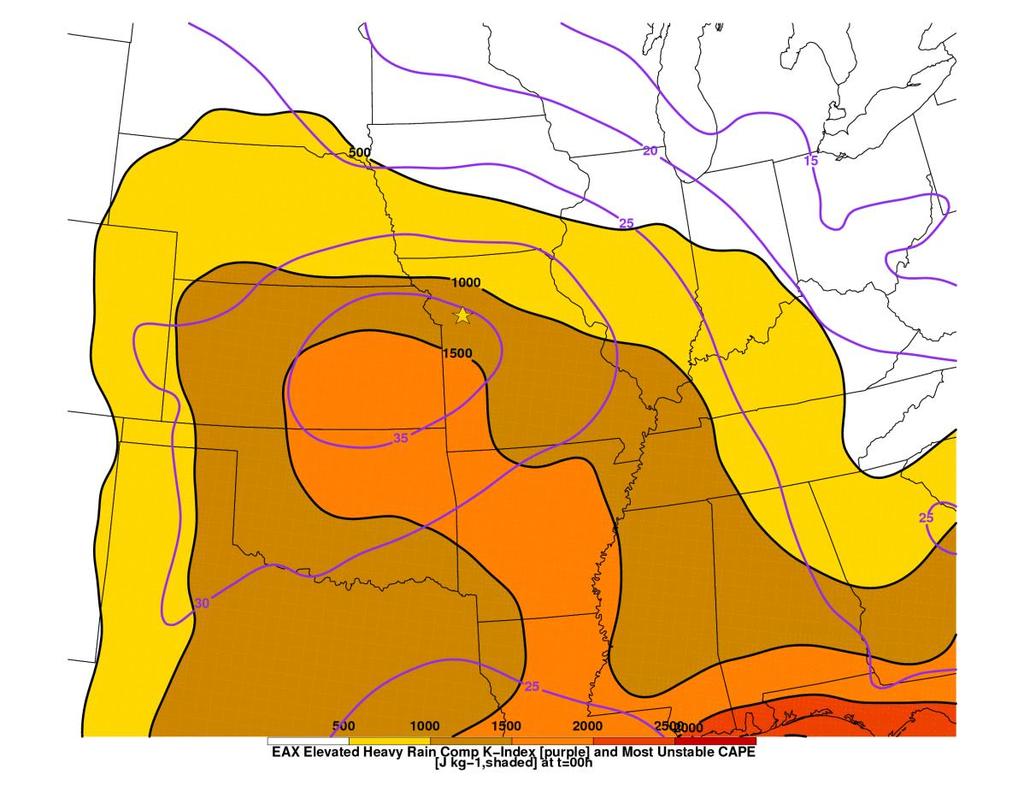
25 Results- Kansas City MUCAPE (color-filled) and K-Index (purple)

26 Results- Kansas City K Index - IQR plots, T=00

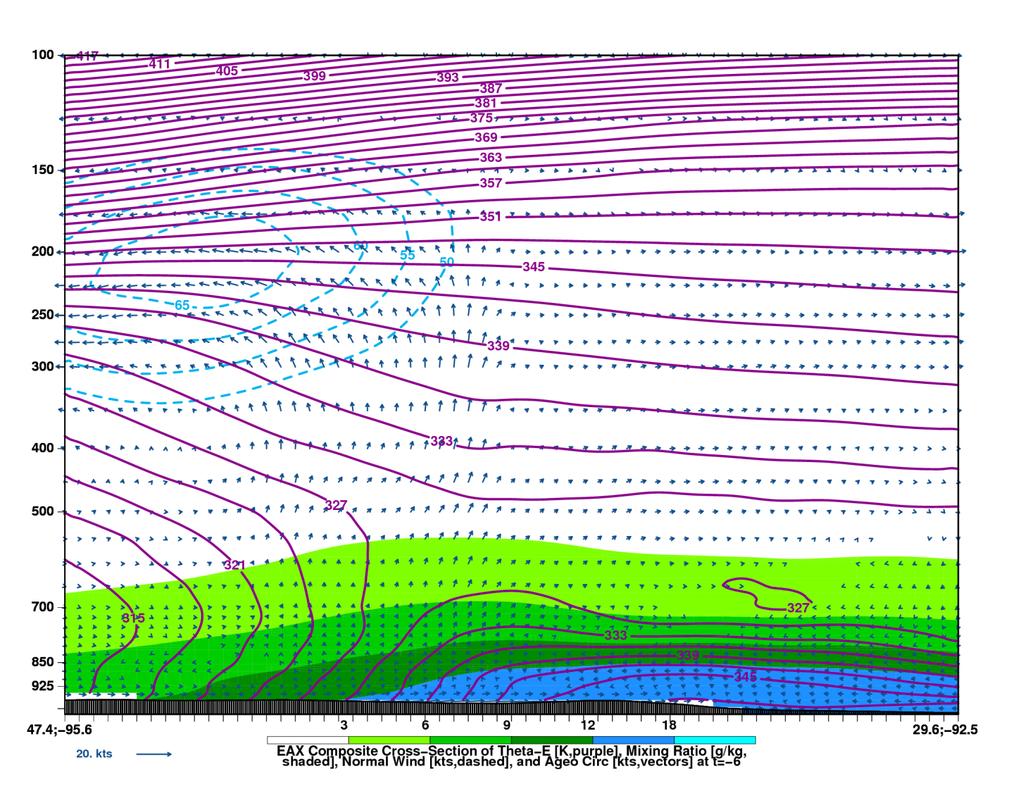
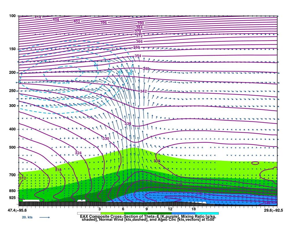
27 Cross-Section Kansas City The X
28 Conclusions
29 Conclusions Unique patterns to look for when forecasting heavyrainfall-producing elevated thunderstorms: Strong signal; strong variability Upper-level jet streak to the northeast of the region Divergence > 3 x 10⁻⁵ s -1 (lift) Event located within or just south of 850-mb θ e advection maximum (convergence max) Signals LLJ from the SSW (moisture; lift; instability) Strong signal; small variability >30 K-index values (instability) Precipitable water values > 1.6 (moisture) 2-m θ e pattern (confirms elevated convection)
30 Conclusions Prior work largely corroborated. However, some novel findings as well MUCAPE decreases while K Index increases X marks the spot in cross sections Interquartile ranges - enhance confidence in forecasting heavy rain events with elevated convection
 Lifting 250-mb DIV > 3 x 10⁻⁵ s -1 Instability K")
31 Conclusions 250-mb Jet Core > 70 kt Moisture PWATs > 1.6 (~40 mm) Lifting 250-mb DIV > 3 x 10⁻⁵ s -1 Instability K Index > 32
32 Future work Find analogs to composite grids Find null events Discover parameters differing for heavy-rainfall vs non-heavy-rainfall events

33 PRECIP Project Use McCoy s forecast method to predict where heavy-rain-producing elevated thunderstorms will occur Deploy teams to collect observational data from storm environment or
P0.98 Composite Analysis of Heavy-Rain-Producing Elevated Thunderstorms in the MO-KS-OK region of the United States
 P0.98 Composite Analysis of Heavy-Rain-Producing Elevated Thunderstorms in the MO-KS-OK region of the United States Laurel P. McCoy and Patrick S. Market Department of Soil, Environmental, and Atmospheric
AN INDEX FOR ANTICIPATING EXCESSIVE PRECIPITATION WITH ELEVATED THUNDERSTORMS
 AN INDEX FOR ANTICIPATING EXCESSIVE PRECIPITATION WITH ELEVATED THUNDERSTORMS Alzina Foscato and Patrick Market Dept. of Soil, Environmental & Atmospheric Sciences University of Missouri Presented to the
An Isentropic Perspective on Two Cases of Elevated Convection. Patrick S. Market Dept. of Soil, Env. & Atmospheric Sciences University of Missouri
 An Isentropic Perspective on Two Cases of Elevated Convection Patrick S. Market Dept. of Soil, Env. & Atmospheric Sciences University of Missouri Elevated Convection INTRODUCTION Colman (1990a,b) Initiated
Dynamic Ensemble Model Evaluation of Elevated Thunderstorms sampled by PRECIP
 Dynamic Ensemble Model Evaluation of Elevated Thunderstorms sampled by PRECIP Joshua S. Kastman, Patrick S. Market, and Neil Fox, University of Missouri, Columbia, MO Session 8B - Numerical Weather Prediction
The Environment of Warm-Season Elevated Thunderstorms Associated with Heavy Rainfall Over the Central United States
 The College at Brockport: State University of New York Digital Commons @Brockport Earth Sciences Faculty Publications Department of the Earth Sciences 0-003 The Environment of Warm-Season Elevated Thunderstorms
Journal of Operational Meteorology Article Characteristics of Major Ice Storms in the Central United States
 Sanders, K. J., C. M. Gravelle, J. P. Gagan, and C. E. Graves, 2013: Characteristics of major ice storms in the central United States. J. Operational Meteor., 1 (10), 100 113, doi: http://dx.doi.org/10.15191/nwajom.2013.0110.
April 13, 2006: Analysis of the Severe Thunderstorms that produced Hail in Southern Wisconsin
 April 13, 2006: Analysis of the Severe Thunderstorms that produced Hail in Southern Wisconsin Danielle Triolo UW Madison Undergraduate 453 Case Study May 5, 2009 ABSTRACT On April 13, 2006 the states of
Joshua M. Boustead *1, and Barbara E. Mayes NOAA/NWS WFO Omaha/Valley, NE. William Gargan, George Phillips, and Jared Leighton NOAA/NWS WFO Topeka, KS
 7B.3 Composite Analysis of Environmental Conditions Favorable for Significant Tornadoes across Eastern Kansas Joshua M. Boustead *1, and Barbara E. Mayes NOAA/NWS WFO Omaha/Valley, NE William Gargan, George
P3.17 THE DEVELOPMENT OF MULTIPLE LOW-LEVEL MESOCYCLONES WITHIN A SUPERCELL. Joshua M. Boustead *1 NOAA/NWS Weather Forecast Office, Topeka, KS
 P3.17 THE DEVELOPMENT OF MULTIPLE LOW-LEVEL MESOCYCLONES WITHIN A SUPERCELL Joshua M. Boustead *1 NOAA/NWS Weather Forecast Office, Topeka, KS Philip N. Schumacher NOAA/NWS Weather Forecaster Office, Sioux
Low-end derecho of 19 August 2017
 Low-end derecho of 19 August 2017 By Richard H. Grumm and Charles Ross National Weather Service State College, PA 1. Overview A cluster of thunderstorms developed in eastern Ohio around 1800 UTC on 19
Severe Weather with a strong cold front: 2-3 April 2006 By Richard H. Grumm National Weather Service Office State College, PA 16803
 Severe Weather with a strong cold front: 2-3 April 2006 By Richard H. Grumm National Weather Service Office State College, PA 16803 1. INTRODUCTION A strong cold front brought severe weather to much of
P5.11 TACKLING THE CHALLENGE OF NOWCASTING ELEVATED CONVECTION
 P5.11 TACKLING THE CHALLENGE OF NOWCASTING ELEVATED CONVECTION Huaqing Cai*, Rita Roberts, Dan Megenhardt, Eric Nelson and Matthias Steiner National Center for Atmospheric Research, Boulder, CO, 80307,
THE SYNOPTIC ENVIRONMENT OF THE 11 APRIL 2001 CENTRAL PLAINS TORNADO OUTBREAK VIEWED IN THREE DIMENSIONS
 P1.1 THE SYNOPTIC ENVIRONMENT OF THE 11 APRIL 2001 CENTRAL PLAINS TORNADO OUTBREAK VIEWED IN THREE DIMENSIONS Daniel D. Nietfeld * NOAA/NWS/WFO Omaha/Valley, NE 1. INTRODUCTION A powerful low pressure
Heavy Rainfall Event of June 2013
 Heavy Rainfall Event of 10-11 June 2013 By Richard H. Grumm National Weather Service State College, PA 1. Overview A 500 hpa short-wave moved over the eastern United States (Fig. 1) brought a surge of
DISCRIMINATION OF ELEVATED CONVECTION BASED ON LOW-LEVEL RADAR-DERIVED CONVERGENCE
 DISCRIMINATION OF ELEVATED CONVECTION BASED ON LOW-LEVEL RADAR-DERIVED CONVERGENCE A Thesis Presented to the Faculty of the Graduate School at the University of Missouri In Partial Fulfillment of the Requirements
Anthony A. Rockwood Robert A. Maddox
 Anthony A. Rockwood Robert A. Maddox An unusually intense MCS produced large hail and wind damage in northeast Kansas and northern Missouri during the predawn hours of June 7 th, 1982. Takes a look at
8.5 DIAGNOSIS AND PREDICTION OF THE 3-4 JUNE 2002 IOWA-ILLINOIS FLOOD
 8.5 DIAGNOSIS AND PREDICTION OF THE 3-4 JUNE 2002 IOWA-ILLINOIS FLOOD James T. Moore Ray A. Wolf Brad L. Mickelson Jeff A. Zogg Charles E. Graves Saint Louis University Earth and Atmospheric Sciences St.
HIGH-RESOLUTION RAWINSONDE OBSERVATIONS OF THE COLD SECTOR PRECIPITATION REGIONS IN TRANSIENT MID-LATITUDE EXTRATROPICAL CYCLONES
 HIGH-RESOLUTION RAWINSONDE OBSERVATIONS OF THE COLD SECTOR PRECIPITATION REGIONS IN TRANSIENT MID-LATITUDE EXTRATROPICAL CYCLONES Patrick S. Market and Katie Crandall Department of Soil, Environmental
Multiscale Analyses of Inland Tropical Cyclone Midlatitude Jet Interactions: Camille (1969) and Danny (1997)
 and Danny (1997)") Multiscale Analyses of Inland Tropical Cyclone Midlatitude Jet Interactions: Camille (1969) and Danny (1997) Matthew Potter, Lance Bosart, and Daniel Keyser Department of Atmospheric and Environmental
Multiscale Analyses of Inland Tropical Cyclone Midlatitude Jet Interactions: Camille (1969) and Danny (1997) Matthew Potter, Lance Bosart, and Daniel Keyser Department of Atmospheric and Environmental
Summary of November Central U.S. Winter Storm By Christopher Hedge
 Summary of November 12-13 2010 Central U.S. Winter Storm By Christopher Hedge Event Overview The first significant snowfall of the 2010-2011 season affected portions of the plains and upper Mississippi
Monteverdi Metr 201 Quiz #4 100 pts.
 DEPARTMENT OF GEOSCIENCES Name San Francisco State University April 27, 2012 Monteverdi Metr 201 Quiz #4 100 pts. A. Definitions. (5 points each for a total of 25 points in this section). (a) Convective
Mesoscale Convective Complexes (or Systems)
") Mesoscale Convective Complexes (or Systems) What is an MCC Mesoscale Convectiv Complexes (MCCs) are organized clusters of storms that have to meet some size and shape criteria: * -32C IR temp > 100,000
Mesoscale Convective Complexes (or Systems) What is an MCC Mesoscale Convectiv Complexes (MCCs) are organized clusters of storms that have to meet some size and shape criteria: * -32C IR temp > 100,000
THUNDERSTORMS Brett Ewing October, 2003
 THUNDERSTORMS Brett Ewing October, 2003 A natural hazard that occurs often on a daily basis in the lower and mid-latitudes is thunderstorms. Thunderstorms is a weather system that can produce lightning,tornadoes,
Minor Winter Flooding Event in northwestern Pennsylvania January 2017
 1. Overview Minor Winter Flooding Event in northwestern Pennsylvania 12-13 January 2017 By Richard H. Grumm National Weather Service State College, PA A combination of snow melt, frozen ground, and areas
On the usage of composite parameters in High-Shear, Low-CAPE environments
 P72 On the usage of composite parameters in High-Shear, Low-CAPE environments Keith D. Sherburn* and Matthew D. Parker Department of Marine, Earth, and Atmospheric Sciences, North Carolina State University,
and 24 mm, hPa lapse rates between 3 and 4 K km 1, lifted index values
 3.2 Composite analysis 3.2.1 Pure gradient composites The composite initial NE report in the pure gradient northwest composite (N = 32) occurs where the mean sea level pressure (MSLP) gradient is strongest
Mid Atlantic Severe Event of 1 May 2017 Central Pennsylvania QLCS event By Richard H. Grumm National Weather Service, State College, PA 16803
 1. Overview Mid Atlantic Severe Event of 1 May 2017 Central Pennsylvania QLCS event By Richard H. Grumm National Weather Service, State College, PA 16803 A strong upper-level wave (Fig.1) moving into a
WxChallenge Model Output Page Tutorial
 WxChallenge Model Output Page Tutorial Brian Tang University at Albany - SUNY 9/25/12 http://www.atmos.albany.edu/facstaff/tang/forecast/ Clicking on square brings up graphic for the specified variable
Heavy rains and precipitable water anomalies August 2010 By Richard H. Grumm And Jason Krekeler National Weather Service State College, PA 16803
 Heavy rains and precipitable water anomalies 17-19 August 2010 By Richard H. Grumm And Jason Krekeler National Weather Service State College, PA 16803 1. INTRODUCTION Heavy rain fell over the Gulf States,
daily (0000, 0600, 1200, and 1800 UTC) National Centers for Environmental
 National Centers for Environmental") 2. Data and Methodology 2.1 Data Sources A climatology of and categorization scheme for ALTs during the warm season (defined here as May September) were developed using gridded data from the four times
2. Data and Methodology 2.1 Data Sources A climatology of and categorization scheme for ALTs during the warm season (defined here as May September) were developed using gridded data from the four times
Mid-Latitude Cyclones and Fronts. Lecture 12 AOS 101
 Mid-Latitude Cyclones and Fronts Lecture 12 AOS 101 Homework 4 COLDEST TEMPS GEOSTROPHIC BALANCE Homework 4 FASTEST WINDS L Consider an air parcel rising through the atmosphere The parcel expands as it
Lec 10: Interpreting Weather Maps
 Lec 10: Interpreting Weather Maps Case Study: October 2011 Nor easter FIU MET 3502 Synoptic Hurricane Forecasts Genesis: on large scale weather maps or satellite images, look for tropical waves (Africa
Ensemble Trajectories and Moisture Quantification for the Hurricane Joaquin (2015) Event
 Event") Ensemble Trajectories and Moisture Quantification for the Hurricane Joaquin (2015) Event Chasity Henson and Patrick Market Atmospheric Sciences, School of Natural Resources University of Missouri 19 September
Ensemble Trajectories and Moisture Quantification for the Hurricane Joaquin (2015) Event Chasity Henson and Patrick Market Atmospheric Sciences, School of Natural Resources University of Missouri 19 September
Isolated severe weather and cold air damming 9 November 2005 By Richard H. Grumm National Weather Service Office State College, PA 16801
 Isolated severe weather and cold air damming 9 November 2005 By Richard H. Grumm National Weather Service Office State College, PA 16801 1. INTRODUCTION Two lines of convection moved over the State of
DEPARTMENT OF EARTH & CLIMATE SCIENCES Name SAN FRANCISCO STATE UNIVERSITY Nov 29, ERTH 360 Test #2 200 pts
 DEPARTMENT OF EARTH & CLIMATE SCIENCES Name SAN FRANCISCO STATE UNIVERSITY Nov 29, 2018 ERTH 360 Test #2 200 pts Each question is worth 4 points. Indicate your BEST CHOICE for each question on the Scantron
Mid-West Heavy rains 18 April 2013
 Abstract: Mid-West Heavy rains 18 April 2013 By Richard H. Grumm and Charles Ross National Weather Service State College, PA The relatively wet conditions during the first 16 days of April 2013 set the
Development of new products by operational forecasters
 Development of new products by operational forecasters Probability of Thunder -algorithm Paavo Korpela Operational meteorologist & developer Safety Weather Centre Finnish Meteorological Institute Content
KANSAS CLIMATE SUMMARY May 2018
 KANSAS CLIMATE SUMMARY May 2018 From Cold to Hot May came close to setting the record as the hottest since 1895. The state-wide average temperature for the month was 70.6 o F. This was 7.2 degrees warmer
KANSAS CLIMATE SUMMARY June 2018
 KANSAS CLIMATE SUMMARY June 2018 Continued Heat While the heat wasn t as dramatic as in May, June still came in as the 7 th warmest since 1895. The statewide average for the month was 77.9 o F. This was
Charles A. Doswell III, Harold E. Brooks, and Robert A. Maddox
 Charles A. Doswell III, Harold E. Brooks, and Robert A. Maddox Flash floods account for the greatest number of fatalities among convective storm-related events but it still remains difficult to forecast
Foundations of Earth Science, 6e Lutgens, Tarbuck, & Tasa
 Foundations of Earth Science, 6e Lutgens, Tarbuck, & Tasa Weather Patterns and Severe Weather Foundations, 6e - Chapter 14 Stan Hatfield Southwestern Illinois College Air masses Characteristics Large body
CLOUDS & THUNDERSTORMS
 Funding provided by NOAA Sectoral Applications Research Project CLOUDS & THUNDERSTORMS Basic Climatology Oklahoma Climatological Survey How are clouds made? Clouds form when air is cooled to its dewpoint
Appalachian Lee Troughs and their Association with Severe Thunderstorms
 Appalachian Lee Troughs and their Association with Severe Thunderstorms Daniel B. Thompson, Lance F. Bosart and Daniel Keyser Department of Atmospheric and Environmental Sciences University at Albany/SUNY,
Part. I Introduction. Part II Scale Characteristics and Climatology of MCSs
 Talking points for MCS teletraining session Part. I Introduction Slide 1 Slides 2-3 Title Objectives Part II Scale Characteristics and Climatology of MCSs Slides 4-5 Climatology of mesoscale convective
Presented by Ertan TURGU*
 Ministry of Forestry and Water Affairs Turkish State Meteorological Service A Case Study: Analysis of Flash Flood Using FFGS Products on 17 January 2016 in Çeşme, Dikili, Izmir and Manisa. Presented by
WEATHER MAPS NAME. Temperature: Dew Point: Wind Direction: Wind Velocity: % of Sky Covered: Current Pressure:
 NAME WEATHER MAPS For decades hundreds of weather stations throughout the United States have been making standard observations of temperature, moisture, air pressure and winds. The data are collected centrally
Summary of High Wind Event of 7 March 2004
 Summary of High Wind Event of 7 March 2004 This event was characterized by a very strong jet streak that developed over North Carolina by 00 UTC 8 March, as seen in the Eta model analysis at 300 mb, with
4.6 A CASE EXAMPLE OF THE ROLE OF WARM-SECTOR CONVECTION IN THE DEVELOPMENT OF MESOSCALE BANDED SNOWFALL: 2003 NOVEMBER 22-24
 4.6 A CASE EXAMPLE OF THE ROLE OF WARM-SECTOR CONVECTION IN THE DEVELOPMENT OF MESOSCALE BANDED SNOWFALL: 2003 NOVEMBER 22-24 Martin A. Baxter Central Michigan University Mt. Pleasant, MI Charles E. Graves
A Comparison of Iowa Flash Flood Events and Eight Common Features of Excessive Rainfall for BRITTANY A. KONRADI 1
 1 A Comparison of Iowa Flash Flood Events and Eight Common Features of Excessive Rainfall for 2006-2011 BRITTANY A. KONRADI 1 Mentors: Melinda Beerends 2, Dr. Kristie Franz 1 Department of Geological and
THE MAP ROOM. BAND ON THE RUN Chasing the Physical Processes Associated with Heavy Snowfall
 THE MAP ROOM BAND ON THE RUN Chasing the Physical Processes Associated with Heavy Snowfall BY CHARLES E. GRAVES, JAMES T. MOORE, MARC J. SINGER, AND SAM NG AFFILIATIONS: GRAVES, MOORE, AND NG Department
KANSAS CLIMATE SUMMARY April 2017
 KANSAS CLIMATE SUMMARY April 2017 Epic Blizzard While much of the month was warmer than normal, the last week brought a return to cold, wintery weather in the western third of the state, and cold rainy
Winter Storm of 15 December 2005 By Richard H. Grumm National Weather Service Office State College, PA 16803
 Winter Storm of 15 December 2005 By Richard H. Grumm National Weather Service Office State College, PA 16803 1. INTRODUCTION A complex winter storm brought snow, sleet, and freezing rain to central Pennsylvania.
ATS 351, Spring 2010 Lab #9 Weather Radar - 55 points
 ATS 351, Spring 2010 Lab #9 Weather Radar - 55 points 1. (5 points) If a radar has a maximum unambiguous range of 300km, what is its PRF? (The speed of light, c, is equal to 3x10 8 m/s) 2. (5 points) Explain
Heavy Rainfall and Flooding of 23 July 2009 By Richard H. Grumm And Ron Holmes National Weather Service Office State College, PA 16803
 Heavy Rainfall and Flooding of 23 July 2009 By Richard H. Grumm And Ron Holmes National Weather Service Office State College, PA 16803 1. INTRODUCTION Heavy rains fall over Pennsylvania and eastern New
National Weather Service-Pennsylvania State University Weather Events
 National Weather Service-Pennsylvania State University Weather Events Eastern United States Winter Storm and Severe Event of 28-29 February 2012 by Richard H. Grumm National Weather Service State College
Middle Latitude Cyclones a storm that forms at middle and high latitudes, outside of the tropics.
 Middle Latitude Cyclones a storm that forms at middle and high latitudes, outside of the tropics. Polar Front Theory a theory that explains the life cycle of mid latitude cyclones and their associated
Chapter 14 Thunderstorm Fundamentals
 Chapter overview: Thunderstorm appearance Thunderstorm cells and evolution Thunderstorm types and organization o Single cell thunderstorms o Multicell thunderstorms o Orographic thunderstorms o Severe
4/18/2010. National Weather Service. Severe Weather Forecasting: A Western North Carolina Case Study
 National Weather Service Severe Weather Forecasting: A Western North Carolina Case Study Laurence G. Lee Science and Operations Officer National Weather Service Greer, SC Plus 13 River Forecast Centers
KANSAS CLIMATE SUMMARY June 2016
 KANSAS CLIMATE SUMMARY June 2016 Summer arrives early June made a quick turn-around with both temperature and precipitation in most of the state. Only the Southwest Division averaged above normal precipitation
Some heavy precipitation issues. AOS C115/C228 Fall 2014
 Some heavy precipitation issues AOS C115/C228 Fall 2014 1 Heavy precipitation at a location = intensity x longevity 2 Common sources of heavy precipitation in U.S. Mesoscale convective systems and vortices
10/21/2012. Chapter 10 Thunderstorms. Part II. Growth and Development of ordinary Cell Thunderstorms Thunderstorm Electrification.
 Chapter 10 Thunderstorms Part I Growth and Development of ordinary Cell Thunderstorms Thunderstorm Electrification Tornadoes Part II Simplified model depicting the life cycle of an ordinary thunderstorm
Weather Basics. Challenges of Winter Weather Forecasting Along the East Coast North American Snow Conference 5/23/16
 Challenges of Winter Weather Forecasting Along the East Coast Sara Croke sara@weatherornot.com Sullivan Brown sully@weatherornot.com @WeatherorNotInc /WeatherOrNotInc 913.722.3955 Weather Basics Moisture
11B.1 INFLUENCE OF DIABATIC POTENTIAL VORTICITY ANOMALIES UPON WARM CONVEYOR BELT FLOW. PART I: FEBRUARY 2003
 INFLUENCE OF DIABATIC POTENTIAL VORTICITY ANOMALIES UPON WARM CONVEYOR BELT FLOW. PART I: 14-15 FEBRUARY 2003 Philip N. Schumacher, NOAA/NWS, Sioux Falls, SD Joshua M. Boustead, NOAA/NWS, Valley, NE Martin
Curriculum Vitae SCOTT MICHAEL ROCHETTE, Ph.D.
 Curriculum Vitae SCOTT MICHAEL ROCHETTE, Ph.D. Permanent Address: Campus Address: 108 Laura Lane The College at Brockport, State University of New York Brockport, NY 14420-9405 Department of the Earth
Initiation of an Elevated Mesoscale Convective System Associated with Heavy Rainfall
 The College at Brockport: State University of New York Digital Commons @Brockport Earth Sciences Faculty Publications Department of the Earth Sciences 12-1996 Initiation of an Elevated Mesoscale Convective
IOP-2 Summary of Operations 03 June UTC 04 June UTC Authors: Market, Kastman
 IOP-2 Summary of Operations 03 June 2014 2200 UTC 04 June 2014 1200 UTC Authors: Market, Kastman IOP-2 focused on the slow-moving warm front that extended east from a cyclone that was situated over eastern
KANSAS CLIMATE SUMMARY October 2016
 KANSAS CLIMATE SUMMARY October 2016 Record warmth Temperatures continued the warmer than normal pattern through much of October. The state-wide average temperature was 60.9 of, or 5.6 degrees warmer than
Examination #3 Wednesday, 28 November 2001
 Name & Signature Dr. Droegemeier Student ID Meteorology 1004 Introduction to Meteorology Fall, 2001 Examination #3 Wednesday, 28 November 2001 BEFORE YOU BEGIN!! Please be sure to read each question CAREFULLY
CoCoRaHs in Missouri: Four Years Later, the Importance of Observations
 Transactions of the Missouri Academy of Science, Volume 43 (2009), pp. 1 12 CoCoRaHs in Missouri: Four Years Later, the Importance of Observations John. T. Moon III 1,2, Patrick E. Guinan 1,2, David J.
Joshua M. Boustead *1 NOAA/NWS WFO Omaha/Valley, NE. Philip N. Schumacher NOAA/NWS WFO Sioux Falls, SD
 11B.2 Influence of Diabatic Potential Vorticity Anomalies upon Warm Conveyor Belt Flow. Part II: 3-5 January 2005 Joshua M. Boustead *1 NOAA/NWS WFO Omaha/Valley, NE Philip N. Schumacher NOAA/NWS WFO Sioux
1. INTRODUCTION 3. VERIFYING ANALYSES
 1.4 VERIFICATION OF NDFD GRIDDED FORECASTS IN THE WESTERN UNITED STATES John Horel 1 *, Bradley Colman 2, Mark Jackson 3 1 NOAA Cooperative Institute for Regional Prediction 2 National Weather Service,
Air Masses, Fronts, Storm Systems, and the Jet Stream
 Air Masses, Fronts, Storm Systems, and the Jet Stream Air Masses When a large bubble of air remains over a specific area of Earth long enough to take on the temperature and humidity characteristics of
Department of Commerce National Oceanic & Atmospheric Administration National Weather Service
 Department of Commerce National Oceanic & Atmospheric Administration National Weather Service NATIONAL WEATHER SERVICE CENTRAL REGION SUPPLEMENT 02-2003 APPLICABLE TO NWSI 10-513 January 6, 2009 Operations
A COMPREHENSIVE 5-YEAR SEVERE STORM ENVIRONMENT CLIMATOLOGY FOR THE CONTINENTAL UNITED STATES 3. RESULTS
 16A.4 A COMPREHENSIVE 5-YEAR SEVERE STORM ENVIRONMENT CLIMATOLOGY FOR THE CONTINENTAL UNITED STATES Russell S. Schneider 1 and Andrew R. Dean 1,2 1 DOC/NOAA/NWS/NCEP Storm Prediction Center 2 OU-NOAA Cooperative
Patterns of Heavy rainfall in the Mid-Atlantic Region 1. INTRODUCTION
 5A.2 Patterns of Heavy rainfall in the Mid-Atlantic Region by Richard H. Grumm * And Ron Holmes National Weather Service Office State College, PA 16802 1. INTRODUCTION The patterns associated with heavy
Investigation of the Arizona Severe Weather Event of August 8 th, 1997
 Investigation of the Arizona Severe Weather Event of August 8 th, 1997 Tim Hollfelder May 10 th, 2006 Abstract Synoptic scale forcings were very weak for these thunderstorms on August 7-8, 1997 over the
3. As warm, moist air moves into a region, barometric pressure readings in the region will generally 1. decrease 2. increase 3.
 Teacher: Mr. Prizzi Castle Learning Review 1 1. Which process most directly results in cloud formation? 1. condensation 3. precipitation 2. transpiration 4. radiation 2. An air mass originating over north
Lecture Outlines PowerPoint. Chapter 19 Earth Science 11e Tarbuck/Lutgens
 Lecture Outlines PowerPoint Chapter 19 Earth Science 11e Tarbuck/Lutgens 2006 Pearson Prentice Hall This work is protected by United States copyright laws and is provided solely for the use of instructors
KANSAS CLIMATE SUMMARY November 2017
 KANSAS CLIMATE SUMMARY November 2017 Dry The major climate feature for November was the dryness. Statewide average precipitation was just 0.10 inches, which is a 3-way tie for the sixth driest November
Earth Science, 11e. Weather Patterns and Severe Storms Chapter 19. Air masses. A cold Canadian air mass Figure Air masses. Air masses 9/5/2012
 2006 Pearson Prentice Hall Lecture Outlines PowerPoint Chapter 19 Earth Science 11e Tarbuck/Lutgens This work is protected by United States copyright laws and is provided solely for the use of instructors
WINTER WEATHER GUIDANCE FROM REGIONAL HISTORICAL ANALOGS. Chad M. Gravelle Saint Louis University, St. Louis, Missouri
 JP3.10 WINTER WEATHER GUIDANCE FROM REGIONAL HISTORICAL ANALOGS Chad M. Gravelle Saint Louis University, St. Louis, Missouri Charles E. Graves Saint Louis University, St. Louis, Missouri John P. Gagan
1. INTRODUCTION. For brevity times are referred to in the format of 20/1800 for 20 August UTC. 3. RESULTS
 Heavy rains and precipitable water anomalies 20-23 August 2010-Draft By Jason Krekeler And Richard Grumm National Weather Service State College, PA 16803 1. INTRODUCTION Heavy rain fell across the central
NWS-PSU Case Study Site 2010 Severe Weather Case
 NWS-PSU Case Study Site 2010 Severe Weather Case New Years Eve Severe Weather Event of 31 December 2010 by Richard H. Grumm National Weather Service State College PA 16083 Abstract: A surge of warm humid
A Detailed Analysis of a Long-Tracked Supercell. Jason T. Martinelli and Andrew Elliott. Fred Glass
 A Detailed Analysis of a Long-Tracked Supercell Jason T. Martinelli and Andrew Elliott Department of Atmospheric Sciences, Creighton University, Omaha, Nebraska Fred Glass National Weather Service Forecast
Shawn M. Milrad Atmospheric Science Program Department of Geography University of Kansas Lawrence, Kansas
 Shawn M. Milrad Atmospheric Science Program Department of Geography University of Kansas Lawrence, Kansas Eyad H. Atallah and John R. Gyakum Department of Atmospheric and Oceanic Sciences McGill University
A Preliminary Severe Winter Storms Climatology for Missouri from
 A Preliminary Severe Winter Storms Climatology for Missouri from 1960-2010 K.L. Crandall and P.S Market University of Missouri Department of Soil, Environmental and Atmospheric Sciences Introduction The
KANSAS CLIMATE SUMMARY June 2017
 KANSAS CLIMATE SUMMARY June 2017 Uneven rainfall The wet May gave way to uneven rainfall in June. The statewide average precipitation was 3.23 inches or 74 percent of normal. The East Central and West
AN INVESTIGATION OF THE JUNE 1984 BARNEVELD, WI TORNADO
 AN INVESTIGATION OF THE JUNE 1984 BARNEVELD, WI TORNADO BRANDON SWEDLUND Department of Atmospheric and Oceanic Sciences, University of Wisconsin, Madison, Wisconsin 13 May 2007 I. Introduction On the morning
Chapter 1 Anatomy of a Cyclone
 Chapter 1 Anatomy of a Cyclone The Beast in the East 15-17 February 2003 Extra-tropical cyclone an area of low pressure outside of the tropics Other names for extra-tropical cyclones: Cyclone Mid-latitude
A Review of Thundersnow Events Across the United States
 A Review of Thundersnow Events Across the United States JoBeth Minniear and Elizabeth Suess 4/18/2010 Table of Contents 1. Introduction.............................1 2. Formation Types.............................1
Forecast for 6/28-7/31. Forecaster: Matthew Brewer Forecast made at: 12z 6/27/2017
 Forecast for 6/28-7/31 Forecaster: Matthew Brewer Forecast made at: 12z 6/27/2017 Whiteface lodge Mesonet Meteogram for the past 24 hours http://www.nysmesonet.org/data/meteogram#?stid=wfmb Whiteface Summit
Oakfield, WI Tornado of July 18 th, 1996: "Everything in its Right Place"
 Oakfield, WI Tornado of July 18 th, 1996: "Everything in its Right Place" Arian Sarsalari Department of Atmospheric and Oceanic Sciences, University of Wisconsin Madison ABSTRACT This paper will serve
The Integration of WRF Model Forecasts for Mesoscale Convective Systems Interacting with the Mountains of Western North Carolina
 Proceedings of The National Conference On Undergraduate Research (NCUR) 2006 The University of North Carolina at Asheville Asheville, North Carolina April 6-8, 2006 The Integration of WRF Model Forecasts
Saturation Fraction and Gross Moist Stability in the Mediterranean environment
 3rd Split Workshop in Atmospheric Physics and Oceanography Friday, May 27th, 2011 Brač Island, Croatia Saturation Fraction and Gross Moist Stability in the Mediterranean environment Raymond et al., 2009:
High Impact Weather Event Week
 http://www.essl.org/ www.essl.org/eswd/ High Impact Weather Event Week A recipe for Thunderstorms For EUMETRAIN Speaker: Helge Tuschy http://www.estofex.org/ Short vita studied Meteorology / Geophysics
Final Examination, MEA 443 Fall 2008, Lackmann
 Place an X here to count it double! Name: Final Examination, MEA 443 Fall 2008, Lackmann If you wish to have the final exam count double and replace your midterm score, place an X in the box above. As
COMPOSITE ANALYSIS OF THUNDERSNOW EVENTS IN THE CENTRAL UNITED STATES
 COMPOSITE ANALYSIS OF THUNDERSNOW EVENTS IN THE CENTRAL UNITED STATES A Thesis Presented to the Faculty of the Graduate School University of Missouri-Columbia In Partial Fulfillment for the Degree Master
Custom Weather Forecast
 1 of 23 Custom Weather Forecast 2018 Chicago Yacht Club s Race To Mackinac- Cruising Division Disclaimer: The user assumes all risk related to the use of this Custom Weather Forecast. The crew of the participating
Vol. VIII, Nr. 6 / 2009
 Fenomene i procese climatice de risc THE 22-27 JULY 2008 SEVERE WEATHER EVENT AN EXAMPLE OF RETROGRADE MEDITERRANEAN CYCLONE FLOOD GINA TIRON,CAROLINA-IRINA OPREA ABSTRACT. The 22-27 July 2008 severe weather
JMA Contribution to SWFDDP in RAV. (Submitted by Yuki Honda and Masayuki Kyouda, Japan Meteorological Agency) Summary and purpose of document
 Summary and purpose of document") WORLD METEOROLOGICAL ORGANIZATION COMMISSION FOR BASIC SYSTEMS OPAG on DPFS DPFS/RAV-SWFDDP-RSMT Doc. 7.1(1) (28.X.2010) SEVERE WEATHER FORECASTING AND DISASTER RISK REDUCTION DEMONSTRATION PROJECT (SWFDDP)
WORLD METEOROLOGICAL ORGANIZATION COMMISSION FOR BASIC SYSTEMS OPAG on DPFS DPFS/RAV-SWFDDP-RSMT Doc. 7.1(1) (28.X.2010) SEVERE WEATHER FORECASTING AND DISASTER RISK REDUCTION DEMONSTRATION PROJECT (SWFDDP)