Some heavy precipitation issues. AOS C115/C228 Fall 2014
|
|
|
- Victor Stafford
- 5 years ago
- Views:
Transcription
1 Some heavy precipitation issues AOS C115/C228 Fall
2 Heavy precipitation at a location = intensity x longevity 2
3 Common sources of heavy precipitation in U.S. Mesoscale convective systems and vortices Orographically induced, trapped or influenced storms Landfalling tropical cyclones 3
4 Mesoscale Convective Systems (MCSs) 4
5 MCSs & precipitation facts MCSs = squall- lines and supercells Large % of warm season rainfall and flash floods (Maddox et al. 1979; Doswell et al. 1996; Schumacher and Johnson 2005) OLen not well forecasted by models (Davis et al. 2003; Bukovsky et al. 2006; Anderson et al. 2007) Supercells olen produce intense but not heavy rainfall Form in highly sheared environments Tend to move quickly, not stay in one place 5

6 U.S. flash flood seasonality Number of events Contribution of warm season MCSs clearly seen Precipitable water higher in warm season 6 Maddox et al. (1979)
7 A common MCS: trailing stratiform squall-line Cellular leading convective line: unsteady, multicellular (e.g., Browning et al. 1976; Fovell and Tan 1998) Trailing region of lighter stratiform precipitation (e.g., Houze 1977; Smull and Houze 1985) Parker and Johnson (2000) Accounts for nearly 60% of line-oriented MCSs (Parker and Johnson 2000) 7

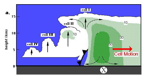
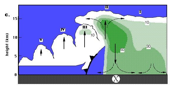
8 Squall-lines usually multicellular 8

9 Storm motion matters How a storm moves over a specific location determines rainfall received 9 Doswell et al. (1996)
10 Forecasting MCS motion (or lack of motion ) 10
11 North Plains 11
12 Rules of thumb Why? Right for the right reason? 12
13 Some common ingredients CAPE (Convective Available Potential Energy) CIN (Convective Inhibition) Precipitable water Vertical shear - magnitude and direction Low-level jet (LLJ) Midlevel cyclonic circulations (potential vorticity anomalies) 13
14 Some common rules of thumb MCSs tend to move towards the most unstable air MCSs back-build towards higher CIN mb layer mean RH 70% Convective cells go with the flow Convective systems follow mb thickness contours MCSs favored where thickness contours diverge Development favored downshear of midlevel cyclonic circulations 14
15 Back-building towards higher CIN Lifting takes longer where there is more resistance 15
16 70% RH rule of thumb RH > 70% Implication: Relative humidity more skillful than absolute humidity and necessary but not sufficient # = precip. category 16 Junker et al. (1999)
17 Cells go with the flow Cells tend to move at speed and direction of mb mass-weighted wind* Agrees with previous observations (e.g, Fankhauser 1964) and theory (classic studies of Kuo and Asai) *Winds around MCS genesis used. Later some deviation to the right often appears Corfidi et al. (1996) 17
18 MCSs tend to follow thickness contours Implication: vertical shear determines MCS orientation and motion. Thickness divergence likely implies rising motion 18
19 Composite severe MCS hodograph Selective composite already excludes non-severe, non-ts squalls Heights marked are km MSL 19 Bluestein and Jain (1985)
20 Composite severe MCS hodograph Cells move at mb wind direction at about 85% its speed Consistent with Corfidi et al (1996) findings. 20 Bluestein and Jain (1985)
21 Composite severe MCS hodograph System moves in direction of low-level shear vector 21 Bluestein and Jain (1985)
22 14 July North Plains Low-level shear vector shown 22
23 14 July North Plains 23

24 14 July North Plains 24
25 The South Plains nocturnal lowlevel jet (LLJ) 25
26 Recall severe squall-line composite Composite dominated by nocturnal cases LLJ LLJ appears as local wind max ~ 0.8 km above ground level (AGL) 26 Bluestein and Jain (1985)
27 South Plains LLJ Enhanced southerly flow over South Plains Most pronounced at night Responsible for moisture advection from Gulf & likely a major player in nocturnal thunderstorms and severe weather 27

28 LLJ occurrences meeting certain criteria - most frequent in Oklahoma - most frequent at night Bonner (1968) 28
29 Explanations for LLJ Oscillation of boundary layer friction (mixing) responding to diurnal heating variation Think Ekman spiral Vertical shear responding to diurnally varying west-east temperature gradients owing to sloped topography Cold air drainage down the Rockies at night Topographic blocking of some form 29
30 Observations of wind speed vs. height for days in which nocturnal LLJ appeared at Ft. Worth, TX - wind speed max about 800 m AGL at midnight and 6 AM local time - note increased low-level shear Midnight and 6 AM local time Bonner (1968) 30
31 Observations of Ft. Worth wind at height of wind max. wind weaker, more southerly during afternoon nighttime wind stronger, more from southwest, elevation lower winds execute circular path over a day Bonner (1968) 31

32 5 June 2004 X = Hays, Kansas, USA 32
33 Mesoscale Convective Vortices (MCVs) 33
34 MCVs Can form behind MCSs like squall lines (Bartles and Maddox 1991) Can survive long after the squall line has decayed Can initiate new convection at another time & place Can cause very heavy precipitation (e.g., Bosart and Sanders 1981; Fritsch et al. 1994; Trier and Davis 2002) Houze (2004) 34

35 8 May

36 8 May

37 Episodes of MCSs & predictability Hovmoller diagrams reveal westwardpropagating MCSs Note envelope of several systems with connections Time increases downward Carbone et al. (2002) 37
 Squall line #1 moves quickly dies around 95 W MCV formed behind squall #1 drifts slowly w/")
38 MCV role in predictability Carbone et al. (2002) Squall line #1 moves quickly dies around 95 W MCV formed behind squall #1 drifts slowly w/ winds Squall line #2 sparked by MCV a day later! moves quickly 38
39 MCV recipe Cyclonic circulations develop beneath diabatic heating Ascent and destabilization on windward side Ascent and destabilization on downshear side Windward and downshear sides can sometimes coincide 39
40 Vorticity Vorticity = circulation per area Vertical vorticity = curl of horizontal wind field Geostrophic vertical vorticity uses geostrophic winds Absolute vorticity = ζ + f 40
41 One way to increase vorticity is to squeeze the circulation into a smaller / (most relevant term) f r ~V if convergence, ζ g increases with time 41
42 Potential vorticity Potential temperature (usually) increases with height Take a cylinder of air between two isentropes It has absolute vorticity = ζ + f Stretch it vertically what happens to its spin (ζ)? 42
43 Potential vorticity It s relative vorticity (spin) increases but its potential vorticity (PV) does not In this case, stretching causes θ/ z decrease so ζ increases (f did not change) 43
44 PV tendency (most relevant term) Q = dθ/dt = heating rate We can change PV by heating or cooling if the heating varies spatially (here, with height) 44
45 Initial geopotential field 45

46 Midtropospheric diabatic heating How does this affect thicknesses? 46
47 Effect on geopotential Think hypsometric or QG geopotential height equations 47
48 Effect on geopotential How does this affect low-level flow? 48
49 Effect on flow L Lowered heights beneath heating; convergence 49
50 Effect on / f r ~V Convergence => cyclonic spin-up 50
")
51 Effect on potential vorticity Q = diabatic heating Positive Q gradient => / ( 51
52 Effect on potential vorticity anticyclonic cyclonic PV = potential vorticity Cyclonic circulations spin up beneath heat sources MCV 52

53 MCV Focus on +PV beneath diabatic heating We are looking North 53 Raymond and Jiang (1990)
54 MCV MCV drifting with mean wind in westerly sheared flow Flow shown is relative to the MCV 54 Raymond and Jiang (1990)
55 MCV Adiabatic ascent induced beneath MCV lifts isentrope 55 Raymond and Jiang (1990)
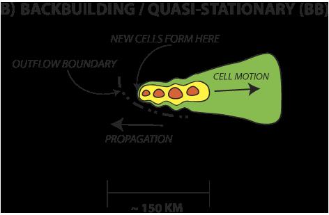
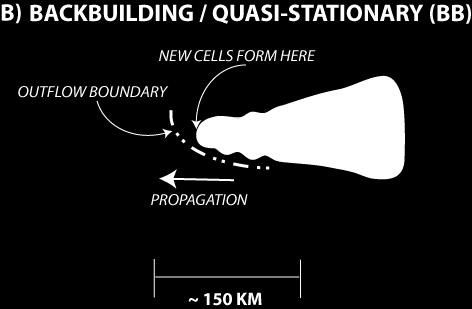
56 MCV Ascent occurs on windward (here, east) side beneath vortex destabilization 56 Raymond and Jiang (1990)
57 MCV Westerly vertical shear implies isentropes tilt upwards towards north (thermal wind equation) 57 Raymond and Jiang (1990)
58 MCV Thus, cyclonic circulation itself results in ascent on east (downshear) side 58 Raymond and Jiang (1990)

59 MCV X X Combination: uplift & destabilization on windward side AND downshear side 59 Raymond and Jiang (1990)
, heights and winds.")
60 MCV and heavy precipitation Based on 6 cases poorly forecasted by models MCV Composite at time of heaviest rain (t = 0h) Heaviest rain south of MCV in 600 mb trough in early morning 600 mb vorticity (color), heights and winds. Map for scale only 60 Schumacher and Johnson (2009)
61 S-J (2009) situation Midlevel MCV See also Fritsch et al. (1994) 61 Schumacher and Johnson (2009)
62 S-J (2009) situation Nocturnally-enhanced low-level jet transports high θ e air; MCV s windward side is to south 62 Schumacher and Johnson (2009)
63 S-J (2009) situation Hairpin hodograph: Downshear side (across vortex) is to south 63 Schumacher and Johnson (2009)
64 S-J (2009) situation South side of MCV is windward at low-levels and downshear relative to midlevel vortex 64 Schumacher and Johnson (2009)
65 S-J (2009) situation Tends to result in very slow-moving, back-building convection south of MCV 65 Schumacher and Johnson (2009)

66 Back-building Ground-relative system speed ~ 0 Schumacher and Johnson (2005) Doswell et al. (1996) 66
67 2013 Colorado flooding the perfect deluge? 67

68 Accumulated rain in inches 231 mm in 1 day 417 mm in 5 days (2013) 82% of average annual precipitation in just 5 days 46% in just ONE day 68
69 Recipe for the deluge Slow moving upper air low over Southwest Strong northward moisture flux Record high precipitable water Frontal and orographic liling 850 mb low- level jet Embedded mesoscale phenomena? 69

70 12Z 11 Sept mb L X Rainfall maximum 70


71 Water vapor imagery X dry moist 71

72 700 mb moisture flux X 72

73 Precipitable water anomaly X 73
74 MAX 00Z 11 Sept mm (1.44 ) 99 th % MEDIAN 74

75 00Z 12 Sept 2013 surface X 75


76 High Resolution Rapid Refresh model analysis X 850 mb wind speed and vectors 00Z 12 Sept Via Prof. Cliff Mass 76
77 Graphical summary 77
78 700 mb moisture streamed northward from tropics 78
79 Precipitable water especially high just east of Colorado 79

80 850 mb winds directed generally upslope 80
81 X year rain event for marked location 81
82 [end] (extra material follows) 82

83 2-3 April

84 2-3 April
 & slows down (prolongs")
85 Why did new cells appear ahead of the mature line? Effectively speeds up (earlier rain) & slows down (prolongs rain) 85
86 New cell initiation ahead of squalllines Unsteady multicellularity excites internal gravity waves 86 Fovell et al. (2006)
87 New cell initiation ahead of squalllines One possible trapping mechanism: the storm anvil 87 Fovell et al. (2006)
88 Trapping mechanism Trapping can occur when a layer of lower l 2 resides over a layer with higher values More general Scorer parameter (c = wave speed) Lowered l 2 can result from decreased stability or creation of a jet-like wind profile Storm anvil does both 88
89 New cell initiation ahead of squalllines The waves themselves disturb the storm inflow 89 Fovell et al. (2006)
90 New cell initiation ahead of squalllines and can create clouds 90 Fovell et al. (2006)
91 New cell initiation ahead of squalllines some of which can develop into precipitating, even deep, convection 91 Fovell et al. (2006)

92 New cell initiation ahead of squalllines Other plausible mechanisms for new cell initiation exist 92 Fovell et al. (2006)
93 New cell initiation ahead of squalllines 14 km 150 km 93 Fovell et al. (2006)

94 New cell initiation ahead of squalllines 14 km 150 km 94 Fovell et al. (2006)
Charles A. Doswell III, Harold E. Brooks, and Robert A. Maddox
 Charles A. Doswell III, Harold E. Brooks, and Robert A. Maddox Flash floods account for the greatest number of fatalities among convective storm-related events but it still remains difficult to forecast
A more detailed and quantitative consideration of organized convection: Part I Cold pool dynamics and the formation of squall lines
 A more detailed and quantitative consideration of organized convection: Part I Cold pool dynamics and the formation of squall lines Note: Lecture notes presented here based on course Daily Weather Laboratory
1 of 7 Thunderstorm Notes by Paul Sirvatka College of DuPage Meteorology. Thunderstorms
 1 of 7 Thunderstorm Notes by Paul Sirvatka College of DuPage Meteorology Thunderstorms There are three types of thunderstorms: single-cell (or air mass) multicell (cluster or squall line) supercell Although
Chapter 3 Convective Dynamics 3.4. Bright Bands, Bow Echoes and Mesoscale Convective Complexes
 Chapter 3 Convective Dynamics 3.4. Bright Bands, Bow Echoes and Mesoscale Convective Complexes Photographs Todd Lindley Bright band associated with stratiform precipitation in a squall line system 1 Bright
Anthony A. Rockwood Robert A. Maddox
 Anthony A. Rockwood Robert A. Maddox An unusually intense MCS produced large hail and wind damage in northeast Kansas and northern Missouri during the predawn hours of June 7 th, 1982. Takes a look at
Wet weeks in the warm season: Patterns and processes supporting widespread multi-day precipitation episodes!
 Wet weeks in the warm season: Patterns and processes supporting widespread multi-day precipitation episodes! Russ S. Schumacher and Samantha L. Lynch! Department of Atmospheric Science, Colorado State
The Boundary Layer and Related Phenomena
 The Boundary Layer and Related Phenomena Jeremy A. Gibbs University of Oklahoma gibbz@ou.edu February 19, 2015 1 / 49 Overview Nocturnal Low-Level Jets Introduction Climatology of LLJs Meteorological Importance
Part. I Introduction. Part II Scale Characteristics and Climatology of MCSs
 Talking points for MCS teletraining session Part. I Introduction Slide 1 Slides 2-3 Title Objectives Part II Scale Characteristics and Climatology of MCSs Slides 4-5 Climatology of mesoscale convective
Weather Systems III: Thunderstorms and Twisters
 Weather Systems III: Thunderstorms and Twisters Review 1. Definition of airmasses? Bergeron classification of air masses 2. Surface weather analysis: Station model, wind speed code, present weather 3.
Solutions to Comprehensive Final Examination Given on Thursday, 13 December 2001
 Name & Signature Dr. Droegemeier Student ID Meteorology 1004 Introduction to Meteorology Fall, 2001 Solutions to Comprehensive Final Examination Given on Thursday, 13 December 2001 BEFORE YOU BEGIN!! Please
Synoptic-Dynamic Meteorology in Midlatitudes
 Synoptic-Dynamic Meteorology in Midlatitudes VOLUME II Observations and Theory of Weather Systems HOWARD B. BLUESTEIN New York Oxford OXFORD UNIVERSITY PRESS 1993 Contents 1. THE BEHAVIOR OF SYNOPTIC-SCALE,
Mesoscale Convective Complexes (or Systems)
") Mesoscale Convective Complexes (or Systems) What is an MCC Mesoscale Convectiv Complexes (MCCs) are organized clusters of storms that have to meet some size and shape criteria: * -32C IR temp > 100,000
Mesoscale Convective Complexes (or Systems) What is an MCC Mesoscale Convectiv Complexes (MCCs) are organized clusters of storms that have to meet some size and shape criteria: * -32C IR temp > 100,000
Shear-Parallel Mesoscale Convective Systems in a Moist Low- Inhibition Mei-Yu Front Environment. Liu and Moncrieff (2017 JAS)
") Shear-Parallel Mesoscale Convective Systems in a Moist Low- Inhibition Mei-Yu Front Environment Liu and Moncrieff (2017 JAS) Introduction Balance of lower-tropospheric wind shear and strength of evaporation-generated
Shear-Parallel Mesoscale Convective Systems in a Moist Low- Inhibition Mei-Yu Front Environment Liu and Moncrieff (2017 JAS) Introduction Balance of lower-tropospheric wind shear and strength of evaporation-generated
Meteorology Lecture 19
 Meteorology Lecture 19 Robert Fovell rfovell@albany.edu 1 Important notes These slides show some figures and videos prepared by Robert G. Fovell (RGF) for his Meteorology course, published by The Great
Multiscale Analyses of Inland Tropical Cyclone Midlatitude Jet Interactions: Camille (1969) and Danny (1997)
 and Danny (1997)") Multiscale Analyses of Inland Tropical Cyclone Midlatitude Jet Interactions: Camille (1969) and Danny (1997) Matthew Potter, Lance Bosart, and Daniel Keyser Department of Atmospheric and Environmental
Multiscale Analyses of Inland Tropical Cyclone Midlatitude Jet Interactions: Camille (1969) and Danny (1997) Matthew Potter, Lance Bosart, and Daniel Keyser Department of Atmospheric and Environmental
ESCI 344 Tropical Meteorology Lesson 11 Tropical Cyclones: Formation, Maintenance, and Intensification
 ESCI 344 Tropical Meteorology Lesson 11 Tropical Cyclones: Formation, Maintenance, and Intensification References: A Global View of Tropical Cyclones, Elsberry (ed.) Global Perspectives on Tropical Cylones:
Evolution and Maintenance of the June 2003 Nocturnal Convection
 Evolution and Maintenance of the 22-23 June 2003 Nocturnal Convection Jerilyn Billings NOAA/NWS Wichita, KS August 6 th, 2011 Work Completed at North Carolina State University for MS Thesis During the
Meteorology Lecture 18
 Meteorology Lecture 18 Robert Fovell rfovell@albany.edu 1 Important notes These slides show some figures and videos prepared by Robert G. Fovell (RGF) for his Meteorology course, published by The Great
Mid-Latitude Cyclones and Fronts. Lecture 12 AOS 101
 Mid-Latitude Cyclones and Fronts Lecture 12 AOS 101 Homework 4 COLDEST TEMPS GEOSTROPHIC BALANCE Homework 4 FASTEST WINDS L Consider an air parcel rising through the atmosphere The parcel expands as it
Chapter 14 Thunderstorm Fundamentals
 Chapter overview: Thunderstorm appearance Thunderstorm cells and evolution Thunderstorm types and organization o Single cell thunderstorms o Multicell thunderstorms o Orographic thunderstorms o Severe
Mesoscale Processes Contributing to Extreme. Rainfall in a Midlatitude Warm-Season Flash. Flood
 Mesoscale Processes Contributing to Extreme Rainfall in a Midlatitude Warm-Season Flash Flood Russ S. Schumacher and Richard H. Johnson Department of Atmospheric Science, Colorado State University, Fort
Tornadogenesis in Supercells: The Three Main Ingredients. Ted Funk
 Tornadogenesis in Supercells: The Three Main Ingredients Ted Funk NWS Louisville, KY Spring 2002 Environmental Parameters Supercells occur within environments exhibiting several wellknown characteristics
Tornadoes forecasting, dynamics and genesis. Mteor 417 Iowa State University Week 12 Bill Gallus
 Tornadoes forecasting, dynamics and genesis Mteor 417 Iowa State University Week 12 Bill Gallus Tools to diagnose severe weather risks Definition of tornado: A vortex (rapidly rotating column of air) associated
Observational Analysis of the Predictability of Mesoscale Convective Systems
 AUGUST 2007 J I R A K A N D C O T T O N 813 Observational Analysis of the Predictability of Mesoscale Convective Systems ISRAEL L. JIRAK AND WILLIAM R. COTTON Department of Atmospheric Science, Colorado
 http://www.ssec.wisc.edu/data/composites.html Red curve: Incoming solar radiation Blue curve: Outgoing infrared radiation. Three-cell model of general circulation Mid-latitudes: 30 to 60 latitude MID-LATITUDES
and 24 mm, hPa lapse rates between 3 and 4 K km 1, lifted index values
 3.2 Composite analysis 3.2.1 Pure gradient composites The composite initial NE report in the pure gradient northwest composite (N = 32) occurs where the mean sea level pressure (MSLP) gradient is strongest
Quasi-Geostrophic Implications
 Chapter 10 Quasi-Geostrophic Implications When you look at a weather chart with all its isolines and plotted data, you need a framework upon which to interpret what you see. Quasi-geostrophic theory provides
Mesoscale Convective Systems. The COMET Program March 2002
 Mesoscale Convective Systems The COMET Program March 2002 Overview! Introduction to MCSs! Squall Lines! Bow Echoes! Mesoscale Convective Complexes Introduction Definition! Mesoscale convective systems
Divergence, Spin, and Tilt. Convergence and Divergence. Midlatitude Cyclones. Large-Scale Setting
 Midlatitude Cyclones Equator-to-pole temperature gradient tilts pressure surfaces and produces westerly jets in midlatitudes Waves in the jet induce divergence and convergence aloft, leading to surface
4/29/2011. Mid-latitude cyclones form along a
 Chapter 10: Cyclones: East of the Rocky Mountain Extratropical Cyclones Environment prior to the development of the Cyclone Initial Development of the Extratropical Cyclone Early Weather Along the Fronts
Gravity waves near convection: causes and consequences
 Gravity waves near convection: causes and consequences Robert Fovell UCLA Atmospheric & Oceanic Sciences rfovell@ucla.edu Outline Basics Mechanically generated stratospheric gravity waves Thermally induced
Tornadoes forecasting, dynamics and genesis. Mteor 417 Iowa State University Week 12 Bill Gallus
 Tornadoes forecasting, dynamics and genesis Mteor 417 Iowa State University Week 12 Bill Gallus Tools to diagnose severe weather risks Definition of tornado: A vortex (rapidly rotating column of air) associated
Investigation of the Arizona Severe Weather Event of August 8 th, 1997
 Investigation of the Arizona Severe Weather Event of August 8 th, 1997 Tim Hollfelder May 10 th, 2006 Abstract Synoptic scale forcings were very weak for these thunderstorms on August 7-8, 1997 over the
MET 3502 Synoptic Meteorology. Lecture 8: September 16, AIRMASSES, FRONTS and FRONTAL ANALYSIS (2)
") MET 3502 Synoptic Meteorology Lecture 8: September 16, 2010 AIRMASSES, FRONTS and FRONTAL ANALYSIS (2) Identifying a cold front on a surface weather map: 1. Surface front is located at the leading edge
MET 3502 Synoptic Meteorology Lecture 8: September 16, 2010 AIRMASSES, FRONTS and FRONTAL ANALYSIS (2) Identifying a cold front on a surface weather map: 1. Surface front is located at the leading edge
The Earth System - Atmosphere III Convection
 The Earth System - Atmosphere III Convection Thunderstorms 1. A thunderstorm is a storm that produces lightning (and therefore thunder) 2. Thunderstorms frequently produce gusty winds, heavy rain, and
P4.9 THE SEVERE THUNDERSTORM OUTBREAK IN FINLAND ON 5 JULY 2002
 P4.9 THE SEVERE THUNDERSTORM OUTBREAK IN FINLAND ON 5 JULY 2002 Ari-Juhani Punkka* and Jenni Teittinen Finnish Meteorological Institute, Helsinki, Finland 1. INTRODUCTION On 5 July 2002 a fast propagating
Weather report 28 November 2017 Campinas/SP
 Weather report 28 November 2017 Campinas/SP Summary: 1) Synoptic analysis and pre-convective environment 2) Verification 1) Synoptic analysis and pre-convective environment: At 1200 UTC 28 November 2017
5.2 MESOSCALE CONVECTIVE VORTICES OBSERVED DURING BAMEX PART II: INFLUENCES ON CONVECTION INITIATION. S. B. Trier, and C. A. Davis
 5.2 MESOSLE ONVETIVE VORTIES OSERVED DURING ME PRT II: INFLUENES ON ONVETION INITITION S.. Trier, and.. Davis National enter for tmospheric Research oulder, olorado 1. INTRODUTION Part I (Davis and Trier
Christopher A. Davis and Stanley B. Trier. National Center for Atmospheric Research 1 Boulder, Colorado
 1.10 Convection Initiation Near Mesoscale Vortices Christopher A. Davis and Stanley B. Trier National Center for Atmospheric Research 1 Boulder, Colorado 1. Background While the focusing of deep, moist
Chapter 3 Convective Dynamics Part V ñ Bright Bands, Bow Echoes and MCCs. Bright band associated with stratiform precipitation in a squall line system
 Chapter 3 Convective Dynamics Part V ñ Bright Bands, Bow Echoes and MCCs Photographs Todd Lindley (This part contains materials taken from UCAR MCS training module) Bright band associated with stratiform
Examination #3 Wednesday, 28 November 2001
 Name & Signature Dr. Droegemeier Student ID Meteorology 1004 Introduction to Meteorology Fall, 2001 Examination #3 Wednesday, 28 November 2001 BEFORE YOU BEGIN!! Please be sure to read each question CAREFULLY
Foundations of Earth Science, 6e Lutgens, Tarbuck, & Tasa
 Foundations of Earth Science, 6e Lutgens, Tarbuck, & Tasa Weather Patterns and Severe Weather Foundations, 6e - Chapter 14 Stan Hatfield Southwestern Illinois College Air masses Characteristics Large body
11A.2 Forecasting Short Term Convective Mode And Evolution For Severe Storms Initiated Along Synoptic Boundaries
 11A.2 Forecasting Short Term Convective Mode And Evolution For Severe Storms Initiated Along Synoptic Boundaries Greg L. Dial and Jonathan P. Racy Storm Prediction Center, Norman, Oklahoma 1. Introduction
OVERLAPPING SCALES and the ATMOSPHERIC CAUSES OF FLOODS. Katherine K. Hirschboeck Laboratory of Tree-ring Research University of Arizona
 OVERLAPPING SCALES and the ATMOSPHERIC CAUSES OF FLOODS Katherine K. Hirschboeck Laboratory of Tree-ring Research University of Arizona Regional Flood Mapping from Hirschboeck, 1991; modified from Baldwin
10/21/2012. Chapter 10 Thunderstorms. Part II. Growth and Development of ordinary Cell Thunderstorms Thunderstorm Electrification.
 Chapter 10 Thunderstorms Part I Growth and Development of ordinary Cell Thunderstorms Thunderstorm Electrification Tornadoes Part II Simplified model depicting the life cycle of an ordinary thunderstorm
Practical Use of the Skew-T, log-p diagram for weather forecasting. Primer on organized convection
 Practical Use of the Skew-T, log-p diagram for weather forecasting Primer on organized convection Outline Rationale and format of the skew-t, log-p diagram Some basic derived diagnostic measures Characterizing
Hurricanes and Tropical Weather Systems:
 Hurricanes and Tropical Weather Systems: An influence on weather in parts of the USA Meteorology 411 Iowa State University Week 2 Bill Gallus Classification/Terminology Tropical Disturbance enhanced convection
Meteorology Lecture 15
 Meteorology Lecture 15 Robert Fovell rfovell@albany.edu 1 Important notes These slides show some figures and videos prepared by Robert G. Fovell (RGF) for his Meteorology course, published by The Great
5D.6 EASTERLY WAVE STRUCTURAL EVOLUTION OVER WEST AFRICA AND THE EAST ATLANTIC 1. INTRODUCTION 2. COMPOSITE GENERATION
 5D.6 EASTERLY WAVE STRUCTURAL EVOLUTION OVER WEST AFRICA AND THE EAST ATLANTIC Matthew A. Janiga* University at Albany, Albany, NY 1. INTRODUCTION African easterly waves (AEWs) are synoptic-scale disturbances
Adam J. French and Matthew D. Parker North Carolina State University, Raleigh, North Carolina
 3.3 THE RESPONSE OF SIMULATED NOCTURNAL CONVECTIVE SYSTEMS TO A LOW-LEVEL JET Adam J. French and Matthew D. Parker North Carolina State University, Raleigh, North Carolina 1. INTRODUCTION Warm season precipitation
ESCI 344 Tropical Meteorology Lesson 8 Tropical Weather Systems
 ESCI 344 Tropical Meteorology Lesson 8 Tropical Weather Systems References: Tropical Climatology (2 nd Ed.), McGregor and Nieuwolt Climate and Weather in the Tropics, Riehl Climate Dynamics of the Tropics,
Tornado Dynamics. Readings:
 Tornado Dynamics Readings: Klemp (1987) Dynamics of Tornadic Thunderstorms (handout) Bluestein Vol II. Section 3.4.8. Rotunno, R., 1986: Tornadoes and tornadogenesis. In: P. Ray (Editor), Mesoscale Meteorology
Type of storm viewed by Spotter A Ordinary, multi-cell thunderstorm. Type of storm viewed by Spotter B Supecell thunderstorm
 ANSWER KEY Part I: Locating Geographical Features 1. The National Weather Service s Storm Prediction Center (www.spc.noaa.gov) has issued a tornado watch on a warm spring day. The watch covers a large
CHAPTER 11 THUNDERSTORMS AND TORNADOES MULTIPLE CHOICE QUESTIONS
 CHAPTER 11 THUNDERSTORMS AND TORNADOES MULTIPLE CHOICE QUESTIONS 1. A thunderstorm is considered to be a weather system. a. synoptic-scale b. micro-scale c. meso-scale 2. By convention, the mature stage
Air Masses, Fronts, Storm Systems, and the Jet Stream
 Air Masses, Fronts, Storm Systems, and the Jet Stream Air Masses When a large bubble of air remains over a specific area of Earth long enough to take on the temperature and humidity characteristics of
True or false: The atmosphere is always in hydrostatic balance. A. True B. False
 Clicker Questions and Clicker Quizzes Clicker Questions Chapter 7 Of the four forces that affect the motion of air in our atmosphere, which is to thank for opposing the vertical pressure gradient force
Test Form: A Key Final Exam: Spring 2011
 Test Form: A Key Final Exam: Spring 2011 Instructions: Write your name (last name and first name) on your bubble sheet. Write your student identification number on the bubble sheet, and carefully and completely
Mesoscale Atmospheric Systems. Surface fronts and frontogenesis. 06 March 2018 Heini Wernli. 06 March 2018 H. Wernli 1
 Mesoscale Atmospheric Systems Surface fronts and frontogenesis 06 March 2018 Heini Wernli 06 March 2018 H. Wernli 1 Temperature (degc) Frontal passage in Mainz on 26 March 2010 06 March 2018 H. Wernli
Observation Homework Due 11/24. Previous Lecture. Midlatitude Cyclones
 Lecture 21 Midlatitude Cyclones Observation Homework Due 11/24 1 2 Midlatitude Cyclones Midlatitude Cyclone or Winter Storm Cyclogenesis Energy Source Life Cycle Air Streams Vertical Structure Storm Hazards
Convective Structures in a Simulated Torrential-Rain-Producing Mesoscale Convective System in East China. Jordan Foley
 Convective Structures in a Simulated Torrential-Rain-Producing Mesoscale Convective System in East China Jordan Foley A scholarly paper in partial fulfillment of the requirements for the degree of Master
Spatial variability of summer precipitation related to the dynamics of the Great Plains low-level jet
 Spatial variability of summer precipitation related to the dynamics of the Great Plains low-level jet Bing Pu and Robert E. Dickinson Department of Geological Sciences, Jackson School of Geosciences The
Chapter 8 cont. Clouds and Storms
 Chapter 8 cont. Clouds and Storms Spring 2007 Clouds and Storms Clouds cover ~ 50% of earth at any time. Clouds are linked to a number of condensation processes. Cloud morphology, cloud types, associated
Chapter 12 Fronts & Air Masses
 Chapter overview: Anticyclones or highs Air Masses o Classification o Source regions o Air masses of North America Fronts o Stationary fronts o Cold fronts o Warm fronts o Fronts and the jet stream o Frontogenesis
Chapter 8 cont. Clouds and Storms. Spring 2018
 Chapter 8 cont. Clouds and Storms Spring 2018 Clouds and Storms Clouds cover ~ 50% of earth at any time. Clouds are linked to a number of condensation processes. Cloud morphology, cloud types, associated
Summary of November Central U.S. Winter Storm By Christopher Hedge
 Summary of November 12-13 2010 Central U.S. Winter Storm By Christopher Hedge Event Overview The first significant snowfall of the 2010-2011 season affected portions of the plains and upper Mississippi
General Circulation. Nili Harnik DEES, Lamont-Doherty Earth Observatory
 General Circulation Nili Harnik DEES, Lamont-Doherty Earth Observatory nili@ldeo.columbia.edu Latitudinal Radiation Imbalance The annual mean, averaged around latitude circles, of the balance between the
Characteristics of extreme convection over equatorial America and Africa
 Characteristics of extreme convection over equatorial America and Africa Manuel D. Zuluaga, K. Rasmussen and R. A. Houze Jr. Atmospheric & Climate Dynamics Seminar Department of Atmospheric Sciences, University
HAZARDOUS WEATHER 1. Dr. Julie Laity Geography 266
 HAZARDOUS WEATHER 1 Dr. Julie Laity Geography 266 Violent Weather Thunderstorms Atmospheric turbulence Lightning and thunder Hail Derechos Tornadoes Tornado measurement and science Tropical Cyclones Hurricanes
Name SOLUTIONS T.A./Section Atmospheric Science 101 Homework #6 Due Thursday, May 30 th (in class)
") Name SOLUTIONS T.A./Section Atmospheric Science 101 Homework #6 Due Thursday, May 30 th (in class) 1. General Circulation Briefly describe where each of the following features is found in the earth s general
Name SOLUTIONS T.A./Section Atmospheric Science 101 Homework #6 Due Thursday, May 30 th (in class) 1. General Circulation Briefly describe where each of the following features is found in the earth s general
THESIS CLIMATOLOGICAL AND RADAR-INDICATED CHARACTERISTICS OF UNITED STATES EXTREME RAIN EVENTS
 THESIS CLIMATOLOGICAL AND RADAR-INDICATED CHARACTERISTICS OF UNITED STATES EXTREME RAIN EVENTS Submitted by Russ Stanley Schumacher Department of Atmospheric Science In partial fulfillment of the requirements
CONVERGENCE, DIVERGENCE, AND VORTICITY
 CHAPTER 1 CONVERGENCE, DIVERGENCE, AND VORTICITY In your reading of the AG2 manual, volume 1, you became familiar with the terms convergence, divergence, and vorticity when used in relation to surface
Summary of High Wind Event of 7 March 2004
 Summary of High Wind Event of 7 March 2004 This event was characterized by a very strong jet streak that developed over North Carolina by 00 UTC 8 March, as seen in the Eta model analysis at 300 mb, with
Fixed Rossby Waves: Quasigeostrophic Explanations and Conservation of Potential Vorticity
 Fixed Rossby Waves: Quasigeostrophic Explanations and Conservation of Potential Vorticity 1. Observed Planetary Wave Patterns After upper air observations became routine, it became easy to produce contour
April 13, 2006: Analysis of the Severe Thunderstorms that produced Hail in Southern Wisconsin
 April 13, 2006: Analysis of the Severe Thunderstorms that produced Hail in Southern Wisconsin Danielle Triolo UW Madison Undergraduate 453 Case Study May 5, 2009 ABSTRACT On April 13, 2006 the states of
Vertical structure. To conclude, we will review the critical factors invloved in the development of extratropical storms.
 Vertical structure Now we will examine the vertical structure of the intense baroclinic wave using three visualization tools: Upper level charts at selected pressure levels Vertical soundings for selected
Ki-Hong Min 1*, Seonhee Choo 2, and Gyuwon Lee 1, and Kyung-Eak Kim 1,3
 Ki-Hong Min 1*, Seonhee Choo 2, and Gyuwon Lee 1, and Kyung-Eak Kim 1,3 1 School of Earth System Sciences, Major in Atmospheric Science, Kyungpook National University, Daegu, South Korea 2 Forecast Technology
Section 13-1: Thunderstorms
 Section 13-1: Thunderstorms Chapter 13 Main Idea: The intensity and duration of thunderstorms depend on the local conditions that create them. Air-mass thunderstorm Mountain thunderstorm Sea-breeze thunderstorm
Oakfield, WI Tornado of July 18 th, 1996: "Everything in its Right Place"
 Oakfield, WI Tornado of July 18 th, 1996: "Everything in its Right Place" Arian Sarsalari Department of Atmospheric and Oceanic Sciences, University of Wisconsin Madison ABSTRACT This paper will serve
Convective Dynamics. Jeremy A. Gibbs. March 10, University of Oklahoma
 Convective Dynamics Jeremy A. Gibbs University of Oklahoma gibbz@ou.edu March 10, 2015 1 / 66 Overview Multicellular Storms Intro Lifecycle Thunderstorm Outflow as a Density Current Cell Regeneration 2
Urban Flash Flooding in Downtown Madison, WI and Southern Wisconsin, 27 July 2006
 Urban Flash Flooding in Downtown Madison, WI and Southern Wisconsin, 27 July 2006 Rebecca Westby Department of Atmospheric and Oceanic Sciences, University of Wisconsin-Madison, Madison, Wisconsin AOS
The Influence of Convective Thermal Forcing on the Three-Dimensional Circulation around Squall Lines
 29 The Influence of Convective Thermal Forcing on the Three-Dimensional Circulation around Squall Lines RAJUL E. PANDYA* National Center for Atmospheric Research, Boulder, Colorado DALE R. DURRAN Department
A Study of the Evolution of Mesoscale Convective Systems Using WSR-88D Data
 JUNE 1998 HILGENDORF AND JOHNSON 437 A Study of the Evolution of Mesoscale Convective Systems Using WSR-88D Data ERIC R. HILGENDORF* AND RICHARD H. JOHNSON Department of Atmospheric Science, Colorado State
Lec 10: Interpreting Weather Maps
 Lec 10: Interpreting Weather Maps Case Study: October 2011 Nor easter FIU MET 3502 Synoptic Hurricane Forecasts Genesis: on large scale weather maps or satellite images, look for tropical waves (Africa
THUNDERSTORMS Brett Ewing October, 2003
 THUNDERSTORMS Brett Ewing October, 2003 A natural hazard that occurs often on a daily basis in the lower and mid-latitudes is thunderstorms. Thunderstorms is a weather system that can produce lightning,tornadoes,
Analysis of Severe Storm Initiation Along Drylines in the Southern Plains
 Analysis of Severe Storm Initiation Along Drylines in the Southern Plains NICOLE L. BARBEE Meteorology Program, Iowa State University, Ames Mentor: Dr. William Gallus 1 1 Department of Geological and Atmospheric
Chapter 9: Weather Patterns
 Chapter 9: Weather Patterns Mid Latitude Cyclones: extratropical cyclones, Nor easters Region southern FL to Alaska Lifecycle and associated weather Regional Influence Polar Front Theory: -Norwegian Cyclone
11B.1 INFLUENCE OF DIABATIC POTENTIAL VORTICITY ANOMALIES UPON WARM CONVEYOR BELT FLOW. PART I: FEBRUARY 2003
 INFLUENCE OF DIABATIC POTENTIAL VORTICITY ANOMALIES UPON WARM CONVEYOR BELT FLOW. PART I: 14-15 FEBRUARY 2003 Philip N. Schumacher, NOAA/NWS, Sioux Falls, SD Joshua M. Boustead, NOAA/NWS, Valley, NE Martin
The Environment of Warm-Season Elevated Thunderstorms Associated with Heavy Rainfall Over the Central United States
 The College at Brockport: State University of New York Digital Commons @Brockport Earth Sciences Faculty Publications Department of the Earth Sciences 0-003 The Environment of Warm-Season Elevated Thunderstorms
Case Study 3: Dryline in TX and OK 3 May 1999
 Case Study 3: Dryline in TX and OK 3 May 1999 Brandy Lumpkins Department of Atmospheric and Oceanic Sciences University of Wisconsin Madison 8 May 2006 ABSTRACT A massive tornadic outbreak swept across
Hurricanes are intense vortical (rotational) storms that develop over the tropical oceans in regions of very warm surface water.
 storms that develop over the tropical oceans in regions of very warm surface water.") Hurricanes: Observations and Dynamics Houze Section 10.1. Holton Section 9.7. Emanuel, K. A., 1988: Toward a general theory of hurricanes. American Scientist, 76, 371-379 (web link). http://ww2010.atmos.uiuc.edu/(gh)/guides/mtr/hurr/home.rxml
Hurricanes: Observations and Dynamics Houze Section 10.1. Holton Section 9.7. Emanuel, K. A., 1988: Toward a general theory of hurricanes. American Scientist, 76, 371-379 (web link). http://ww2010.atmos.uiuc.edu/(gh)/guides/mtr/hurr/home.rxml
Synoptic Meteorology II: Self-Development in the IPV Framework. 5-7 May 2015
 Synoptic Meteorology II: Self-Development in the IPV Framework 5-7 May 2015 Readings: Section 5.3.6 of Midlatitude Synoptic Meteorology. Introduction In this and other recent lectures, we have developed
Forecasting Weather: Air Masses and Fronts
 Forecasting Weather: Air Masses and Fronts Weather is a combination of local conditions at any one time. It's what's happening outside right now, right here. Weather includes: Temperature Humidity Air
Impacts of the April 2013 Mean trough over central North America
 Impacts of the April 2013 Mean trough over central North America By Richard H. Grumm National Weather Service State College, PA Abstract: The mean 500 hpa flow over North America featured a trough over
Satellites, Weather and Climate Module 9: Air/sea interactions winter cyclogenesis
 Satellites, Weather and Climate Module 9: Air/sea interactions winter cyclogenesis Winter storms things to consider Deep moisture Thermal discontinuity Favorable surface and upper level features Geographical
CHAPTER 8 NUMERICAL SIMULATIONS OF THE ITCZ OVER THE INDIAN OCEAN AND INDONESIA DURING A NORMAL YEAR AND DURING AN ENSO YEAR
 CHAPTER 8 NUMERICAL SIMULATIONS OF THE ITCZ OVER THE INDIAN OCEAN AND INDONESIA DURING A NORMAL YEAR AND DURING AN ENSO YEAR In this chapter, comparisons between the model-produced and analyzed streamlines,
- tornadoes. Further Reading: Chapter 08 of the text book. Outline. - cyclones and anti-cyclones. -tropical storms. -Storm surge
 (1 of 16) Further Reading: Chapter 08 of the text book Outline - cyclones and anti-cyclones - tornadoes -tropical storms -Storm surge (2 of 16) Introduction Previously, We talked about fronts and their
QUASI-STATIONARY CONVECTIVE SYSTEMS FORMING PERPENDICULAR TO, AND ABOVE THE COLD POOLS OF, STRONG BOW ECHOES. A Thesis KELLY M.
 QUASI-STATIONARY CONVECTIVE SYSTEMS FORMING PERPENDICULAR TO, AND ABOVE THE COLD POOLS OF, STRONG BOW ECHOES A Thesis by KELLY M. KEENE Submitted to the Office of Graduate Studies of Texas A&M University
A Numerical Study of the Along-Line Variability of a Frontal Squall Line during PRE-STORM
 2544 MONTHLY WEATHER REVIEW VOLUME 125 A Numerical Study of the Along-Line Variability of a Frontal Squall Line during PRE-STORM STÉPHANE BÉLAIR Recherche en Prévision Numérique, Environment Canada, Dorval,
Mid Atlantic Severe Event of 1 May 2017 Central Pennsylvania QLCS event By Richard H. Grumm National Weather Service, State College, PA 16803
 1. Overview Mid Atlantic Severe Event of 1 May 2017 Central Pennsylvania QLCS event By Richard H. Grumm National Weather Service, State College, PA 16803 A strong upper-level wave (Fig.1) moving into a
Inner core dynamics: Eyewall Replacement and hot towers
 Inner core dynamics: Eyewall Replacement and hot towers FIU Undergraduate Hurricane Internship Lecture 4 8/13/2012 Why inner core dynamics is important? Current TC intensity and structure forecasts contain