Shear-Parallel Mesoscale Convective Systems in a Moist Low- Inhibition Mei-Yu Front Environment. Liu and Moncrieff (2017 JAS)
|
|
|
- Dwain Hall
- 5 years ago
- Views:
Transcription

1 Shear-Parallel Mesoscale Convective Systems in a Moist Low- Inhibition Mei-Yu Front Environment Liu and Moncrieff (2017 JAS)
2 Introduction Balance of lower-tropospheric wind shear and strength of evaporation-generated cold pool is highly important in governing TS squall line organization (Rotunno et al. 1988; RKW theory) For other types of convective systems (eg. TL-AS MCS), the mechanism regulating their organization (eg. back-building) is highly dependent on near-surface cold outflow (Parker 2007a) Role of cold pool much more uncertain in Mei-yu front environment! Crucial characteristic of mei-yu front environment is the nearly-saturated low troposphere -> Limited evaporative cooling and weakened density current Past results on MCSs in near-saturated environments i. Lack of cold pool forcing increases the importance of other processes (eg. mesoscale forcing. gravity wave) [Crook and Moncrieff 1988] ii. Studies for quasi-stationary heavily raining MCS suggests that convectively-generated gravity wave forcing is influential for flow organization [Schumacher and Johnson 2008; Schumacher 2009, 2015] iii. Fovell et al. (2006) has established the relationship between gravity wave forcing and the observed "convective initialization prior to squall line gust front" phenomenon
 Sounding used previously by Yamasaki (2009) used to simulate a 2004 mei-yu rainband, under strong westerly shear Mei-yu environment is approximated by the following perturbation")
3 Experiment Design WRF model [2401x1801x101 grid points, (0.5km horizontal, 0.2km vertical) Sounding used previously by Yamasaki (2009) used to simulate a 2004 mei-yu rainband, under strong westerly shear Mei-yu environment is approximated by the following perturbation equations: Initialized sounding These equations define a 200-km-wide moisture front, corresponding to a Tv gradient of ~0.3K/100km 1 sensitivity test (No rainwater evaporative cooling)


4 Does weak cold pool play a role? System evolution similar to CTRL (initial downstream propagation due to ambient wind advection -> quasistationary -> slow upstream propagation) MCS is narrower than CTRL and extends further upstream Hypothesis Turning off rainwater evaporation -> Less diabatic cooling to neutralize latent heat release-> Stronger MCS Much heavier precipitation and precipitation seems to be "locked" along moisture front Shear-parallel, quasi-stationary, elongated rainband is produced is both simulations


 The MCS is characterized by \"upstream")
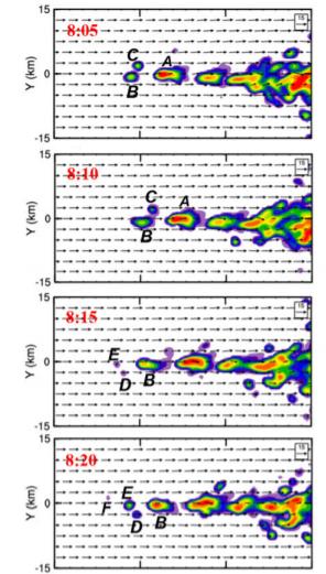
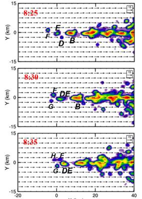
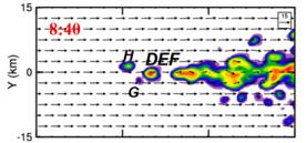
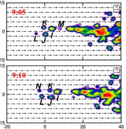
5 Surface precipitation Strong convective precip centered on moisture front, weak stratiform precip downstream Quasi-stationary MCS moves upstream slowly due to repeated convective initiation The overall structure similar to backbuilding/parallel-stratiform MCS (Parker 2007a,b; Wang et al. 2014) The MCS is characterized by "upstream building" as cells regenerate to the east of MCS system
")
 (b)")
 (c) Potential")
 (d) Pressure perturbations")
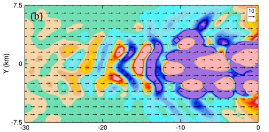
6 Mesoscale kinematic and thermodynamic characteristics (a) Condensate (shading, g/kg) and u-wind perturbation (contours) (b) Vertical Velocity (shading, m/s) and RH (contours) (c) Potential temperature perturbation (shading, oc) (d) Pressure perturbations (shading, Pa) Houze et al. 1989

7

 Gust f n=1 heating")
8 Gravity-waves-generated lifting ront n=1+2 heating Nicholls et al. (1991) Gust f n=1 heating Fovell et al. (2006)
 Condensate (shading, g/kg) and u-wind")
 and RH (contours)")
 (h) Pressure perturbations")
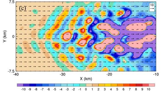
9 Does weak cold pool play a role? (e) Condensate (shading, g/kg) and u-wind perturbation (contours) (f) Vertical Velocity (shading, m/s) and RH (contours) (g) Potential temperature perturbation (shading, oc) (h) Pressure perturbations (shading, Pa) Seems not!

] Potential Temperature Perturbation (Shading) Relative Humidity")
10 Gravity wave activity I. Upstream-propagating deep mode 04hr 2nd Gravest mode 5.5hr Gravest mode Vertical Velocity [Contours - Updraft (solid), downdraft (dashed)] Potential Temperature Perturbation (Shading) Relative Humidity >98% (Green Contours at 5.5hr) Cloud Boundary (Black Contours at 5.5hr)

11 Gravity wave activity I. Upstream-propagating deep mode LCL~ m LFC~ m Trajectories of 200 parcels released upstream of MCS (a) Altitude time in W-E direction (b) Altitude changes with time

12 Gravity wave activity II. Downstream-moving slow mode 06hr
 Potential temperature perturbation")
13 Gravity wave activity II. Downstream-moving slow mode Vertical Velocity (Contours, cm/s) Potential temperature perturbation (shading) X-axis wind component (contours, m/s) Cloud Boundaries (Green contours)

14 Gravity wave activity II. Downstream-moving slow mode 8.5hr 10hr 9.5hr 1km vertical velocity (cm/s)
15 Gravity wave activity II. Downstream-moving slow mode Propagating Mode Temperature Advection Diabatic heating
16 Gravity wave activity II. Downstream-moving slow mode Growing Mode If there is no phase difference between Q, w' (beta=0) Either: (1) ci=0 (disturbance cannot amplify) (2) U-cr=0 (Existence of critical level)

17 Gravity wave activity II. Downstream-moving slow mode Upstream scorer parameter across moisture front (10^-6 m^-2)
18 Summarizing gravity wave's role H High-frequency GW Destabilizes environment (cooling tendency in moist low troposphere, creating shallow cloud deck upstream) L Low-frequency GW Triggering boundary layer cumulus cloud within the preconditioned saturated layer Disparities between simulated system and Fovell et al. (2006) New CI triggered ahead of gust front can be harmful to F06's system by undercutting unstable air inflow; GW cell triggering is vital in this study GWs in F06 originated from parent storm, move upstream, trigger new convection; Highfrequency GWs in this study is excited upstream by boundary layer cumulus and moves downstream by ambient wind Wave-ducting mechanism in F06 is uppertropospheric outflow from MCS; Background flow curvature in this study

19 Some remaining issues & MCS 3D structure Line-normal wind (contour+vector) averaged between h Line-parallel (u-wind) momentum transport vertical profile along moisture front

 Upstream-building, shear-parallel evolution and strong transverse circulation resemble Dudhia and Moncrieff (1987), Khouider and")
20 Some remaining issues & MCS 3D structure Throughflow Up-down flow Jump updraft Jump downdraft Rear-to-front downdraft completely absent in simulated MCS MCS propagates in wavelike manner Most boundary layer parcels are transported to 12-14km by jump updraft, a portion descends in updown flow Most parcels above 6km traverse system in throughflow branch with small lifting 3D spatial & airflow structure, wavelike propagation similar to Moncrieff and Lane (2015) Upstream-building, shear-parallel evolution and strong transverse circulation resemble Dudhia and Moncrieff (1987), Khouider and Moncrieff (2015)
21 THE END Thank you for listening
Chapter 14 Thunderstorm Fundamentals
 Chapter overview: Thunderstorm appearance Thunderstorm cells and evolution Thunderstorm types and organization o Single cell thunderstorms o Multicell thunderstorms o Orographic thunderstorms o Severe
A more detailed and quantitative consideration of organized convection: Part I Cold pool dynamics and the formation of squall lines
 A more detailed and quantitative consideration of organized convection: Part I Cold pool dynamics and the formation of squall lines Note: Lecture notes presented here based on course Daily Weather Laboratory
Chapter 3 Convective Dynamics 3.4. Bright Bands, Bow Echoes and Mesoscale Convective Complexes
 Chapter 3 Convective Dynamics 3.4. Bright Bands, Bow Echoes and Mesoscale Convective Complexes Photographs Todd Lindley Bright band associated with stratiform precipitation in a squall line system 1 Bright
Chapter 3 Convective Dynamics
 Chapter 3 Convective Dynamics Photographs Todd Lindley 3.2 Ordinary or "air-mass storm 3.2.1. Main Characteristics Consists of a single cell (updraft/downdraft pair) Forms in environment characterized
Convective Dynamics. Jeremy A. Gibbs. March 10, University of Oklahoma
 Convective Dynamics Jeremy A. Gibbs University of Oklahoma gibbz@ou.edu March 10, 2015 1 / 66 Overview Multicellular Storms Intro Lifecycle Thunderstorm Outflow as a Density Current Cell Regeneration 2
The 5th Research Meeting of Ultrahigh Precision Meso-scale Weather Prediction, Nagoya University, Higashiyama Campus, Nagoya, 9 March 2015
 The 5th Research Meeting of Ultrahigh Precision Meso-scale Weather Prediction, Nagoya University, Higashiyama Campus, Nagoya, 9 March 2015 The effects of moisture conditions on the organization and intensity
Charles A. Doswell III, Harold E. Brooks, and Robert A. Maddox
 Charles A. Doswell III, Harold E. Brooks, and Robert A. Maddox Flash floods account for the greatest number of fatalities among convective storm-related events but it still remains difficult to forecast
Chapter 8 cont. Clouds and Storms
 Chapter 8 cont. Clouds and Storms Spring 2007 Clouds and Storms Clouds cover ~ 50% of earth at any time. Clouds are linked to a number of condensation processes. Cloud morphology, cloud types, associated
Theories on the Optimal Conditions of Long-Lived Squall Lines
 Theories on the Optimal Conditions of Long-Lived Squall Lines References: Thorpe, A. J., M. J. Miller, and M. W. Moncrieff, 1982: Two-dimensional convection in nonconstant shear: A model of midlatitude
Gravity waves near convection: causes and consequences
 Gravity waves near convection: causes and consequences Robert Fovell UCLA Atmospheric & Oceanic Sciences rfovell@ucla.edu Outline Basics Mechanically generated stratospheric gravity waves Thermally induced
1 August 2006 An Investigation of a Bow Echo along the Wasatch Front. Randy Graham and Chris Gibson 6 April 2007
 1 August 2006 An Investigation of a Bow Echo along the Wasatch Front Randy Graham and Chris Gibson 6 April 2007 Overview Environment review Review of terrain-induced discrete propagation Bow Echo interactions
TOPICS: What are Thunderstorms? Ingredients Stages Types Lightning Downburst and Microburst
 THUNDERSTORMS TOPICS: What are Thunderstorms? Ingredients Stages Types Lightning Downburst and Microburst What are Thunderstorms? A storm produced by a cumulonimbus cloud that contains lightning and thunder
Chapter 5. Atmospheric Moisture
 Chapter 5 Atmospheric Moisture hydrologic cycle--movement of water in all forms between earth & atmosphere Humidity: amount of water vapor in air vapor pressure saturation vapor pressure absolute humidity
Theories on the Optimal Conditions of Long-Lived Squall Lines
 Theories on the Optimal Conditions of Long-Lived Squall Lines References: Thorpe, A. J., M. J. Miller, and M. W. Moncrieff, 1982: Two -dimensional convection in nonconstant shear: A model of midlatitude
The Influence of Convective Thermal Forcing on the Three-Dimensional Circulation around Squall Lines
 29 The Influence of Convective Thermal Forcing on the Three-Dimensional Circulation around Squall Lines RAJUL E. PANDYA* National Center for Atmospheric Research, Boulder, Colorado DALE R. DURRAN Department
Mechanisms of Cell Regeneration, Development, and Propagation within a Two-Dimensional Multicell Storm
 15 MAY 1998 LIN ET AL. 1867 Mechanisms of Cell Regeneration, Development, and Propagation within a Two-Dimensional Multicell Storm YUH-LANG LIN, ROY L. DEAL, AND MARK S. KULIE Department of Marine, Earth,
Mesoscale Convective Systems. The COMET Program March 2002
 Mesoscale Convective Systems The COMET Program March 2002 Overview! Introduction to MCSs! Squall Lines! Bow Echoes! Mesoscale Convective Complexes Introduction Definition! Mesoscale convective systems
Chapter 8 cont. Clouds and Storms. Spring 2018
 Chapter 8 cont. Clouds and Storms Spring 2018 Clouds and Storms Clouds cover ~ 50% of earth at any time. Clouds are linked to a number of condensation processes. Cloud morphology, cloud types, associated
Environmental stability control of the intensity of squall lines under low-level shear conditions
 JOURNAL OF GEOPHYSICAL RESEARCH, VOL. 112,, doi:10.1029/2007jd008793, 2007 Environmental stability control of the intensity of squall lines under low-level shear conditions Tetsuya Takemi 1 Received 12
ESCI 344 Tropical Meteorology Lesson 11 Tropical Cyclones: Formation, Maintenance, and Intensification
 ESCI 344 Tropical Meteorology Lesson 11 Tropical Cyclones: Formation, Maintenance, and Intensification References: A Global View of Tropical Cyclones, Elsberry (ed.) Global Perspectives on Tropical Cylones:
Thunderstorm: a cumulonimbus cloud or collection of cumulonimbus clouds featuring vigorous updrafts, precipitation and lightning
 Thunderstorm: a cumulonimbus cloud or collection of cumulonimbus clouds featuring vigorous updrafts, precipitation and lightning Thunderstorms are responsible for most of what we refer to as severe weather,
Meteorology Lecture 18
 Meteorology Lecture 18 Robert Fovell rfovell@albany.edu 1 Important notes These slides show some figures and videos prepared by Robert G. Fovell (RGF) for his Meteorology course, published by The Great
Practical Use of the Skew-T, log-p diagram for weather forecasting. Primer on organized convection
 Practical Use of the Skew-T, log-p diagram for weather forecasting Primer on organized convection Outline Rationale and format of the skew-t, log-p diagram Some basic derived diagnostic measures Characterizing
Clouds and turbulent moist convection
 Clouds and turbulent moist convection Lecture 2: Cloud formation and Physics Caroline Muller Les Houches summer school Lectures Outline : Cloud fundamentals - global distribution, types, visualization
Thunderstorm: a cumulonimbus cloud or collection of cumulonimbus clouds featuring vigorous updrafts, precipitation and lightning
 Thunderstorm: a cumulonimbus cloud or collection of cumulonimbus clouds featuring vigorous updrafts, precipitation and lightning Thunderstorm: a cumulonimbus cloud or collection of cumulonimbus clouds
Part. I Introduction. Part II Scale Characteristics and Climatology of MCSs
 Talking points for MCS teletraining session Part. I Introduction Slide 1 Slides 2-3 Title Objectives Part II Scale Characteristics and Climatology of MCSs Slides 4-5 Climatology of mesoscale convective
An Examination of the Dynamics of a Rear-inflow Jet Associated with an Idealized Mesoscale Convective System
 University of Wisconsin Milwaukee UWM Digital Commons Theses and Dissertations May 2017 An Examination of the Dynamics of a Rear-inflow Jet Associated with an Idealized Mesoscale Convective System Caitlin
Large-Eddy Simulations of Tropical Convective Systems, the Boundary Layer, and Upper Ocean Coupling
 DISTRIBUTION STATEMENT A. Approved for public release; distribution is unlimited. Large-Eddy Simulations of Tropical Convective Systems, the Boundary Layer, and Upper Ocean Coupling Eric D. Skyllingstad
1 of 7 Thunderstorm Notes by Paul Sirvatka College of DuPage Meteorology. Thunderstorms
 1 of 7 Thunderstorm Notes by Paul Sirvatka College of DuPage Meteorology Thunderstorms There are three types of thunderstorms: single-cell (or air mass) multicell (cluster or squall line) supercell Although
Warm season forecasting! Some material adapted from Material Produced at COMET for their Residence Course in Hydrometeorology
 Warm season forecasting! Some material adapted from Material Produced at COMET for their Residence Course in Hydrometeorology 1 Outline! Types of stability and application to forecasting! Dry and moist
Solutions to Comprehensive Final Examination Given on Thursday, 13 December 2001
 Name & Signature Dr. Droegemeier Student ID Meteorology 1004 Introduction to Meteorology Fall, 2001 Solutions to Comprehensive Final Examination Given on Thursday, 13 December 2001 BEFORE YOU BEGIN!! Please
Some heavy precipitation issues. AOS C115/C228 Fall 2014
 Some heavy precipitation issues AOS C115/C228 Fall 2014 1 Heavy precipitation at a location = intensity x longevity 2 Common sources of heavy precipitation in U.S. Mesoscale convective systems and vortices
9D.3 THE INFLUENCE OF VERTICAL WIND SHEAR ON DEEP CONVECTION IN THE TROPICS
 9D.3 THE INFLUENCE OF VERTICAL WIND SHEAR ON DEEP CONVECTION IN THE TROPICS Ulrike Wissmeier, Robert Goler University of Munich, Germany 1 Introduction One does not associate severe storms with the tropics
11A.2 Forecasting Short Term Convective Mode And Evolution For Severe Storms Initiated Along Synoptic Boundaries
 11A.2 Forecasting Short Term Convective Mode And Evolution For Severe Storms Initiated Along Synoptic Boundaries Greg L. Dial and Jonathan P. Racy Storm Prediction Center, Norman, Oklahoma 1. Introduction
Tornadogenesis in Supercells: The Three Main Ingredients. Ted Funk
 Tornadogenesis in Supercells: The Three Main Ingredients Ted Funk NWS Louisville, KY Spring 2002 Environmental Parameters Supercells occur within environments exhibiting several wellknown characteristics
Evolution and Maintenance of the June 2003 Nocturnal Convection
 Evolution and Maintenance of the 22-23 June 2003 Nocturnal Convection Jerilyn Billings NOAA/NWS Wichita, KS August 6 th, 2011 Work Completed at North Carolina State University for MS Thesis During the
Discrete Propagation in Numerically Simulated Nocturnal Squall Lines
 DECEMBER 2006 F O V E L L E T A L. 3735 Discrete Propagation in Numerically Simulated Nocturnal Squall Lines ROBERT G. FOVELL, GRETCHEN L. MULLENDORE, AND SEUNG-HEE KIM Department of Atmospheric and Oceanic
Convective Structures in a Simulated Torrential-Rain-Producing Mesoscale Convective System in East China. Jordan Foley
 Convective Structures in a Simulated Torrential-Rain-Producing Mesoscale Convective System in East China Jordan Foley A scholarly paper in partial fulfillment of the requirements for the degree of Master
ATS 351, Spring 2010 Lab #11 Severe Weather 54 points
 ATS 351, Spring 2010 Lab #11 Severe Weather 54 points Question 1 (10 points): Thunderstorm development a) Sketch and describe the stages of development of a single cell thunderstorm. About how long does
MESOSCALE CONVECTIVE SYSTEMS
 MESOSCALE CONVECTIVE SYSTEMS Robert A. Houze Jr. Department of Atmospheric Sciences University of Washington Seattle, Washington, USA Received 19 January 2004; revised 5 August 2004; accepted 8 November
Sensitivity of a Cloud-Resolving Model to Bulk and Explicit Bin Microphysical Schemes. Part II: Cloud Microphysics and Storm Dynamics Interactions
 22 J O U R N A L O F T H E A T M O S P H E R I C S C I E N C E S VOLUME 66 Sensitivity of a Cloud-Resolving Model to Bulk and Explicit Bin Microphysical Schemes. Part II: Cloud Microphysics and Storm Dynamics
SEVERE AND UNUSUAL WEATHER
 SEVERE AND UNUSUAL WEATHER Basic Meteorological Terminology Adiabatic - Referring to a process without the addition or removal of heat. A temperature change may come about as a result of a change in the
MEA 716 Exercise, BMJ CP Scheme With acknowledgements to B. Rozumalski, M. Baldwin, and J. Kain Optional Review Assignment, distributed Th 2/18/2016
 MEA 716 Exercise, BMJ CP Scheme With acknowledgements to B. Rozumalski, M. Baldwin, and J. Kain Optional Review Assignment, distributed Th 2/18/2016 We have reviewed the reasons why NWP models need to
Weather Systems III: Thunderstorms and Twisters
 Weather Systems III: Thunderstorms and Twisters Review 1. Definition of airmasses? Bergeron classification of air masses 2. Surface weather analysis: Station model, wind speed code, present weather 3.
777 GROUNDSCHOOL Temperature, Stability, Fronts, & Thunderstorms
 777 GROUNDSCHOOL 2018 Temperature, Stability, Fronts, & Thunderstorms The Atmosphere Heating Transfer of heat occurs thru Radiation Advection Convection Matter changes states due to the amount of heat
Effects of Upper-Level Shear on the Structure and Maintenance of Strong Quasi-Linear Mesoscale Convective Systems
 APRIL 2006 C O N I G L I O E T A L. 1231 Effects of Upper-Level Shear on the Structure and Maintenance of Strong Quasi-Linear Mesoscale Convective Systems MICHAEL C. CONIGLIO, DAVID J. STENSRUD, AND LOUIS
A Numerical Investigation of the Effects of Dry Air Aloft on Deep Convection
 140 M O N T H L Y W E A T H E R R E V I E W VOLUME 138 A Numerical Investigation of the Effects of Dry Air Aloft on Deep Convection RICHARD P. JAMES AND PAUL M. MARKOWSKI Department of Meteorology, The
Examination #3 Wednesday, 28 November 2001
 Name & Signature Dr. Droegemeier Student ID Meteorology 1004 Introduction to Meteorology Fall, 2001 Examination #3 Wednesday, 28 November 2001 BEFORE YOU BEGIN!! Please be sure to read each question CAREFULLY
Summary of High Wind Event of 7 March 2004
 Summary of High Wind Event of 7 March 2004 This event was characterized by a very strong jet streak that developed over North Carolina by 00 UTC 8 March, as seen in the Eta model analysis at 300 mb, with
Hurricanes are intense vortical (rotational) storms that develop over the tropical oceans in regions of very warm surface water.
 storms that develop over the tropical oceans in regions of very warm surface water.") Hurricanes: Observations and Dynamics Houze Section 10.1. Holton Section 9.7. Emanuel, K. A., 1988: Toward a general theory of hurricanes. American Scientist, 76, 371-379 (web link). http://ww2010.atmos.uiuc.edu/(gh)/guides/mtr/hurr/home.rxml
Hurricanes: Observations and Dynamics Houze Section 10.1. Holton Section 9.7. Emanuel, K. A., 1988: Toward a general theory of hurricanes. American Scientist, 76, 371-379 (web link). http://ww2010.atmos.uiuc.edu/(gh)/guides/mtr/hurr/home.rxml
Mesoscale Processes Contributing to Extreme. Rainfall in a Midlatitude Warm-Season Flash. Flood
 Mesoscale Processes Contributing to Extreme Rainfall in a Midlatitude Warm-Season Flash Flood Russ S. Schumacher and Richard H. Johnson Department of Atmospheric Science, Colorado State University, Fort
P1.16 ADIABATIC LAPSE RATES IN TORNADIC ENVIRONMENTS
 P1.16 ADIABATIC LAPSE RATES IN TORNADIC ENVIRONMENTS Matthew D. Parker Convective Storms Group, The Mesoscale Nexus in Atmospheric Sciences North Carolina State University, Raleigh, North Carolina 1. INTRODUCTION
10/21/2012. Chapter 10 Thunderstorms. Part II. Growth and Development of ordinary Cell Thunderstorms Thunderstorm Electrification.
 Chapter 10 Thunderstorms Part I Growth and Development of ordinary Cell Thunderstorms Thunderstorm Electrification Tornadoes Part II Simplified model depicting the life cycle of an ordinary thunderstorm
Large-Eddy Simulations of Tropical Convective Systems, the Boundary Layer, and Upper Ocean Coupling
 DISTRIBUTION STATEMENT A. Approved for public release; distribution is unlimited. Large-Eddy Simulations of Tropical Convective Systems, the Boundary Layer, and Upper Ocean Coupling Eric D. Skyllingstad
Convectively Generated Gravity Waves and Their Effect on the Cloud Environment
 15 AUGUST 2001 LANE AND REEDER 2427 Convectively Generated Gravity Waves and Their Effect on the Cloud Environment TODD P. LANE AND MICHAEL J. REEDER Department of Mathematics and Statistics, Monash University,
contact with ground for 1 hour plus, starting 1500 MDT moved N., covered about 37 km width varied m
 Goal for today: Finish Ch. 11 Lightning, Thunder & Tornadoes 16 Nov., 2011 Edmonton tornado 31 July 1987 contact with ground for 1 hour plus, starting 1500 MDT moved N., covered about 37 km width varied
Synoptic-Dynamic Meteorology in Midlatitudes
 Synoptic-Dynamic Meteorology in Midlatitudes VOLUME II Observations and Theory of Weather Systems HOWARD B. BLUESTEIN New York Oxford OXFORD UNIVERSITY PRESS 1993 Contents 1. THE BEHAVIOR OF SYNOPTIC-SCALE,
P4.9 THE SEVERE THUNDERSTORM OUTBREAK IN FINLAND ON 5 JULY 2002
 P4.9 THE SEVERE THUNDERSTORM OUTBREAK IN FINLAND ON 5 JULY 2002 Ari-Juhani Punkka* and Jenni Teittinen Finnish Meteorological Institute, Helsinki, Finland 1. INTRODUCTION On 5 July 2002 a fast propagating
Daniel R. Adriaansen * University of North Dakota, Grand Forks, ND. M. J. Alexander NWRA/Colorado Research Associates Div.
 9.5 OBSERVATIONS OF TROPOSPHERIC, CONVECTIVELY GENERATED GRAVITY WAVES FROM ATMOSPHERIC PROFILING PLATFORMS Daniel R. Adriaansen * University of North Dakota, Grand Forks, ND M. J. Alexander NWRA/Colorado
Observations of a squall line and its near environment using high-frequency. rawinsonde launches during VORTEX2. George H. Bryan
 Observations of a squall line and its near environment using high-frequency rawinsonde launches during VORTEX2 George H. Bryan National Center for Atmospheric Research, 1 Boulder, Colorado and Matthew
AMERICAN METEOROLOGICAL SOCIETY
 AMERICAN METEOROLOGICAL SOCIETY Monthly Weather Review EARLY ONLINE RELEASE This is a preliminary PDF of the author-produced manuscript that has been peer-reviewed and accepted for publication. Since it
A Numerical Study of the Along-Line Variability of a Frontal Squall Line during PRE-STORM
 2544 MONTHLY WEATHER REVIEW VOLUME 125 A Numerical Study of the Along-Line Variability of a Frontal Squall Line during PRE-STORM STÉPHANE BÉLAIR Recherche en Prévision Numérique, Environment Canada, Dorval,
Mid-Latitude Cyclones and Fronts. Lecture 12 AOS 101
 Mid-Latitude Cyclones and Fronts Lecture 12 AOS 101 Homework 4 COLDEST TEMPS GEOSTROPHIC BALANCE Homework 4 FASTEST WINDS L Consider an air parcel rising through the atmosphere The parcel expands as it
Divergence, Spin, and Tilt. Convergence and Divergence. Midlatitude Cyclones. Large-Scale Setting
 Midlatitude Cyclones Equator-to-pole temperature gradient tilts pressure surfaces and produces westerly jets in midlatitudes Waves in the jet induce divergence and convergence aloft, leading to surface
Large-Eddy Simulations of Tropical Convective Systems, the Boundary Layer, and Upper Ocean Coupling
 DISTRIBUTION STATEMENT A. Approved for public release; distribution is unlimited. Large-Eddy Simulations of Tropical Convective Systems, the Boundary Layer, and Upper Ocean Coupling Eric D. Skyllingstad
Anthony A. Rockwood Robert A. Maddox
 Anthony A. Rockwood Robert A. Maddox An unusually intense MCS produced large hail and wind damage in northeast Kansas and northern Missouri during the predawn hours of June 7 th, 1982. Takes a look at
Myung-Sook Park, Russell L. Elsberry and Michael M. Bell. Department of Meteorology, Naval Postgraduate School, Monterey, California, USA
 Latent heating rate profiles at different tropical cyclone stages during 2008 Tropical Cyclone Structure experiment: Comparison of ELDORA and TRMM PR retrievals Myung-Sook Park, Russell L. Elsberry and
Impact of Graupel Parameterization Schemes on Idealized Bow Echo Simulations
 APRIL 2013 A D A M S-S E L I N E T A L. 1241 Impact of Graupel Parameterization Schemes on Idealized Bow Echo Simulations REBECCA D. ADAMS-SELIN Atmospheric and Environmental Research, Inc., Lexington,
2.2 Sounding composite construction. 2.3 Vertical velocity retrieval
 7.1 DROPSONDE DERIVED STRUCTURE OF MESOSCALE CONVECTIVE SYSTEMS OBSERVED DURING BAMEX James Correia Jr and R. W. Arritt ; Dept. of Agronomy, Iowa State University, Ames, IA 1. Introduction The Bow echo
F = ma. ATS 150 Global Climate Change Winds and Weather. Scott Denning CSU CMMAP 1. Please read Chapter 6 from Archer Textbook
 Winds and Weather Please read Chapter 6 from Archer Textbook Circulation of the atmosphere and oceans are driven by energy imbalances Energy Imbalances What Makes the Wind Blow? Three real forces (gravity,
Tornadoes forecasting, dynamics and genesis. Mteor 417 Iowa State University Week 12 Bill Gallus
 Tornadoes forecasting, dynamics and genesis Mteor 417 Iowa State University Week 12 Bill Gallus Tools to diagnose severe weather risks Definition of tornado: A vortex (rapidly rotating column of air) associated
A numerical study of cell merger over Cuba Part II: sensitivity to environmental conditions
 Ann. Geophys., 24, 2793 2808, 2006 European Geosciences Union 2006 Annales Geophysicae A numerical study of cell merger over Cuba Part II: sensitivity to environmental conditions D. Pozo 1, I. Borrajero
On the effect of forward shear and reversed shear baroclinic flows for polar low developments. Thor Erik Nordeng Norwegian Meteorological Institute
 On the effect of forward shear and reversed shear baroclinic flows for polar low developments Thor Erik Nordeng Norwegian Meteorological Institute Outline Baroclinic growth a) Normal mode solution b) Initial
USAMA ANBER. Lamont-Doherty Earth Observatory, Palisades, and Department of Earth and Environmental Sciences, Columbia University, New York, New York
 2976 J O U R N A L O F T H E A T M O S P H E R I C S C I E N C E S VOLUME 71 Response of Atmospheric Convection to Vertical Wind Shear: Cloud-System-Resolving Simulations with Parameterized Large-Scale
Idealized Nonhydrostatic Supercell Simulations in the Global MPAS
 Idealized Nonhydrostatic Supercell Simulations in the Global Joe Klemp, Bill Skamarock, and Sang-Hun Park National Center for Atmospheric Research Boulder, Colorado Typical characteristics: Supercell Thunderstorms
MET Lecture 34 Downbursts
 MET 4300 Lecture 34 Downbursts Downbursts A strong downdraft that originates within the lower part of a cumulus cloud or thunderstorms and spreads out at the surface Downbursts do not require strong thunderstorms
Test Form: A Key Final Exam: Spring 2011
 Test Form: A Key Final Exam: Spring 2011 Instructions: Write your name (last name and first name) on your bubble sheet. Write your student identification number on the bubble sheet, and carefully and completely
The Earth System - Atmosphere III Convection
 The Earth System - Atmosphere III Convection Thunderstorms 1. A thunderstorm is a storm that produces lightning (and therefore thunder) 2. Thunderstorms frequently produce gusty winds, heavy rain, and
OBSERVATIONS OF COLD POOL PROPERTIES IN MESOSCALE CONVECTIVE SYSTEMS DURING BAMEX
 JP5J.12 OBSERVATIONS OF COLD POOL PROPERTIES IN MESOSCALE CONVECTIVE SYSTEMS DURING BAMEX George Bryan, David Ahijevych, Christopher Davis, Stanley Trier, and Morris Weisman National Center for Atmospheric
On Trade-Wind Cumulus Cold Pools
 On Trade-Wind Cumulus Cold Pools Paquita Zuidema & Zhujun Li contributions from Reg Hill, Ludovic Bariteau, Bob Rilling, Chris Fairall, Alan Brewer, Bruce Albrecht, Jeff Hare if you can t explain something
Chapter 3 Convective Dynamics Part VI. Supercell Storms. Supercell Photos
 Chapter 3 Convective Dynamics Part VI. Supercell Storms Photographs Todd Lindley (This part contains materials taken from UCAR MCS training module) Supercell Photos 1 Introduction A supercel storm is defined
Cloud-to-Ground Lightning Production in Strongly Forced, Low- Instability Convective Lines
 Cloud-to-Ground Lightning Production in Strongly Forced, Low- Instability Convective Lines Matthew S. Van Den Broeke National Weather Center Research Experiences for Undergraduates, and Valparaiso University
USING PROGRAM HURRICANE. Download all the files, including the (empty) output subdirectory into a new folder on your machine.
 output subdirectory into a new folder on your machine.") USING PROGRAM HURRICANE Download all the files, including the (empty) output subdirectory into a new folder on your machine. QuickStart: First compile hurr.f. Modify the first column of the input file
USING PROGRAM HURRICANE Download all the files, including the (empty) output subdirectory into a new folder on your machine. QuickStart: First compile hurr.f. Modify the first column of the input file
On Trade-Wind Cumulus Cold Pools
 On Trade-Wind Cumulus Cold Pools Paquita Zuidema & Zhujun Li Reg Hill, Ludovic Bariteau, Bob Rilling, Chris Fairall, Alan Brewer, Bruce Albrecht, Jeff Hare key finding from RICO: nearly all cloud producing
Chapter 3 Convective Dynamics Part V ñ Bright Bands, Bow Echoes and MCCs. Bright band associated with stratiform precipitation in a squall line system
 Chapter 3 Convective Dynamics Part V ñ Bright Bands, Bow Echoes and MCCs Photographs Todd Lindley (This part contains materials taken from UCAR MCS training module) Bright band associated with stratiform
Air Mass Thunderstorms. Air Mass Thunderstorms. Air Mass Thunderstorms. Lecture 26 Air Mass Thunderstorms and Lightning
 Lecture 26 and Lightning Life Cycle Environment Climatology Lightning 1 2 Short-lived, isolated thunderstorms that are not severe are often called air-mass thunderstorms. There are three stages describing
Clouds and atmospheric convection
 Clouds and atmospheric convection Caroline Muller CNRS/Laboratoire de Météorologie Dynamique (LMD) Département de Géosciences ENS M2 P7/ IPGP 1 What are clouds? Clouds and atmospheric convection 3 What
16.4 SENSITIVITY OF TORNADOGENESIS IN VERY-HIGH RESOLUTION NUMERICAL SIMULATIONS TO VARIATIONS IN MODEL MICROPHYSICAL PARAMETERS
 1. SENSITIVITY OF TORNADOGENESIS IN VERY-HIGH RESOLUTION NUMERICAL SIMULATIONS TO VARIATIONS IN MODEL MICROPHYSICAL PARAMETERS Nathan A. Snook* and Ming Xue University of Oklahoma, Norman, Oklahoma 1.
Advanced Spotter Training Lesson 4: The Nature of Thunderstorms
 Advanced Spotter Training 2009 Lesson 4: The Nature of Thunderstorms From Last Time We discussed the different ways to make air rise. We discussed convection, convergence, and the different kinds of fronts.
Boundary layer equilibrium [2005] over tropical oceans
![Boundary layer equilibrium [2005] over tropical oceans](/thumbs/96/128963638.jpg "Boundary layer equilibrium [2005] over tropical oceans") Boundary layer equilibrium [2005] over tropical oceans Alan K. Betts [akbetts@aol.com] Based on: Betts, A.K., 1997: Trade Cumulus: Observations and Modeling. Chapter 4 (pp 99-126) in The Physics and Parameterization
Boundary layer equilibrium [2005] over tropical oceans Alan K. Betts [akbetts@aol.com] Based on: Betts, A.K., 1997: Trade Cumulus: Observations and Modeling. Chapter 4 (pp 99-126) in The Physics and Parameterization
MAN ZHANG DA-LIN ZHANG. Department of Atmospheric and Oceanic Science, University of Maryland, College Park, College Park, Maryland
 184 M O N T H L Y W E A T H E R R E V I E W VOLUME 140 Subkilometer Simulation of a Torrential-Rain-Producing Mesoscale Convective System in East China. Part I: Model Verification and Convective Organization
Victor Homar * and David J. Stensrud NOAA/NSSL, Norman, Oklahoma
 3.5 SENSITIVITIES OF AN INTENSE CYCLONE OVER THE WESTERN MEDITERRANEAN Victor Homar * and David J. Stensrud NOAA/NSSL, Norman, Oklahoma 1. INTRODUCTION The Mediterranean region is a very active cyclogenetic
Cumulus parameterization in non-convection-resolving models
 Cumulus parameterization in non-convection-resolving models Given a column profile of model variables*, what convective tendencies will* occur? Hard questions: *1 is mean thermo. sounding enough information?»if
Quasi-Geostrophic Implications
 Chapter 10 Quasi-Geostrophic Implications When you look at a weather chart with all its isolines and plotted data, you need a framework upon which to interpret what you see. Quasi-geostrophic theory provides
NWP Equations (Adapted from UCAR/COMET Online Modules)
") NWP Equations (Adapted from UCAR/COMET Online Modules) Certain physical laws of motion and conservation of energy (for example, Newton's Second Law of Motion and the First Law of Thermodynamics) govern
NWP Equations (Adapted from UCAR/COMET Online Modules) Certain physical laws of motion and conservation of energy (for example, Newton's Second Law of Motion and the First Law of Thermodynamics) govern
Experiments with Idealized Supercell Simulations
 Latent Heat Nudging in almo: Experiments with Idealized Supercell Simulations Daniel Leuenberger and Andrea Rossa MeteoSwiss Talk Outline Introduction Supercell Storms Characteristics Reference simulation
Q. Deng a, NYU Abu Dhabi G. Hernandez-Duenas b, UNAM A. Majda, Courant S. Stechmann, UW-Madison L.M. Smith, UW-Madison
 Minimal Models for Precipitating Turbulent Convection Q. Deng a, NYU Abu Dhabi G. Hernandez-Duenas b, UNAM A. Majda, Courant S. Stechmann, UW-Madison L.M. Smith, UW-Madison Contours of rain water in a
Numerical Simulation of Torrential Rainfall and Vortical Hot Towers in a Midlatitude Mesoscale Convective System
 ATMOSPHERIC AND OCEANIC SCIENCE LETTERS, 2009, VOL. 2, NO. 4, 189 193 Numerical Simulation of Torrential Rainfall and Vortical Hot Towers in a Midlatitude Mesoscale Convective System ZHANG Man 1,2,3, Da-Lin
Mesoscale Convective Complexes (or Systems)
") Mesoscale Convective Complexes (or Systems) What is an MCC Mesoscale Convectiv Complexes (MCCs) are organized clusters of storms that have to meet some size and shape criteria: * -32C IR temp > 100,000
Mesoscale Convective Complexes (or Systems) What is an MCC Mesoscale Convectiv Complexes (MCCs) are organized clusters of storms that have to meet some size and shape criteria: * -32C IR temp > 100,000
 Identification of Predictors for Nowcasting Heavy Rainfall In Taiwan --------------------- Part II: Storm Characteristics and Nowcasting Applications Challenges in Developing Nowcasting Applications for