Rainfall data analysis and storm prediction system
|
|
|
- Liliana Colleen Paul
- 5 years ago
- Views:
Transcription
.")
1 Rainfall data analysis and storm prediction system SHABARIRAM, M. E. Available from Sheffield Hallam University Research Archive (SHURA) at: This document is the author deposited version. You are advised to consult the publisher's version if you wish to cite from it. Published version SHABARIRAM, M. E. (2017). Rainfall data analysis and storm prediction system. In: Computational Intelligence for Societal Development in Developing Countries (CISDIDC), Sheffield Hallam University, 17 February (Unpublished) Copyright and re-use policy See Sheffield Hallam University Research Archive
2 Rainfall data analysis and Storm Prediction System Presented by C.P.Shabariram M.E., Assistant Professor
3 Problem Analysis The main problem is that big rainfall data stored in relational database is as input. System is implemented on Graph search which involves multiple scan of same data. Finally the system is run a single server without applying any distributed technology. The main objective is that preprocessing technique is used to filter the unnecessary rainfall data and analyzing only the meaningfull data.
4 Abstract Rainfall fall is collected to predict the storm warning from the hydrological data. This is considered as research idea as it consumes large number of records from the distributed systems. In this work, we proposed a novel solution to manage the data based on spatial temporal characteristic and Map Reduce Framework. The Work load is classified using Support Vector Machine to initialize the Map and Reduce function. It uses the feature selection and reduction algorithm to extract feature entity attribute. Various Rainstorm concepts prediction achieved using big raw rainfall data. Three concepts are defined local, hourly and overall storms. The proposed system serves as a tool for predict rain storm from large amount of rainfall data in effective manner. This system improves the performance in terms of accuracy and efficiency.
5 SYSTEM REQUIREMENTS Hardware Requirements: Processor RAM Hard Disk : Intel Pentium i3 : 2GB : Minimum 2GB free space Software Requirements: Operating System : Windows 8.1 Tool : Hadoop IDE : Eclipse Language : Java
6 Literature Survey Paper Tile Author Description Advantages Disadvantage s 1. Using Mapreduce to Speed Up Storm Identification from Big Raw Rainfall Data 2. Simplified Data Processing Large Clusters on 3. Rainfall Depth- Duration- Frequency Curves and Their Uncertainties K. Jitkajornwanich, U. Gupta, R. Elmasri, L. Fegaras, J.McEnery and J. Dean and S. Ghemawat A. Overeem, T. A. Buishand, and I. Holleman Relevant characteristics storm is identified from raw rainfall data. original raw rainfall data text files instead of using the data in the relational database. Implementation of Mapreduce runs on a large clusters of commodity machine effects of dependence between the maximum rainfalls for different durations on the estimation of DDF curves The performance of the new storm identification system is significantly improved, based on previous one The runtime system takes care of execution, handling errors program (ie) It is used as Statistical literature for the estimating maximum region the rainfall parallelization of computation in storm identification based on area and centre. Network bandwidth is a scare source Large samples are needed to estimate this shape parameter accurately or data from several sites in a region
7 continued 4. Experiences on A. Cary, Z. Sun, V. It describes the Computation is It is not applied to Processing Spatial Hristidis, and N. Rishe problems of r-tree, improved, that leads to high complex spatial Data Mapreduce with which is used as spatial access methods high linear scalability. problem 5. Statistical W. H. Asquith, M. C. The analysis is based on It helps to find the storm It is not suitable for Characteristics of Roussel, T. G. hourly rainfall data inter event time and specifying all sites in a Storm Inter event Cleveland, X. Fang, and recorded by NWS duration particular location Time, Depth and D. B.Thompson, Duration for Eastern New Mexico, Oklahoma and Texas
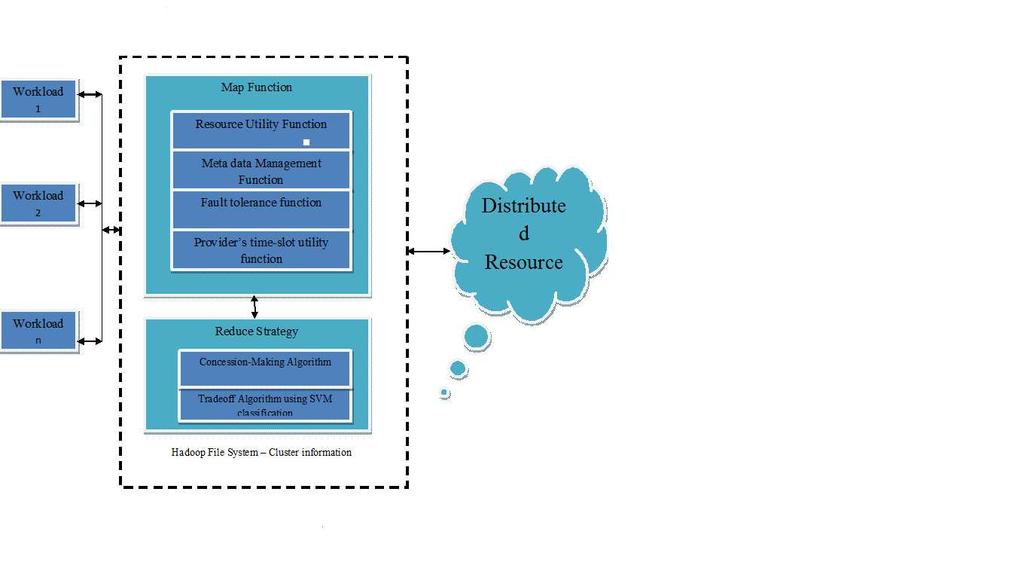
8 SYSTEM ARCHITECTURE
9 PROPOSED SYSTEM The reduction in number of records allows faster querying and mining of storm data. The framework is compatible with the original location-specific analysis of storms It helps the hydrologists by helping them to analyze data easier more efficiently.
10 Modules Modelling the Mapreduce framework for Task Processing. Classification of the data to mapper phase process based on the Spatial Temporal Characteristics using SVM.
11 Modeling the MapReduce for Taskprocessing MapReduce is a programming Model that is associated with rainfall data for task processing and generating data. The computation takes a set input key/value pairs and produces a set of output key/value pairs. Map method includes Resource Utility function Metadata Management function Fault tolerance function Providers Time slot utility function Reduce Method includes Concession Making algorithm
12 Classification of the data to mapper phase process based on the Spatial Temporal Characteristics using SVM Map Process takes caries of the partitioning the spatial data of the rainfall data. The support vector machine is used as a data mining technique to extract informative hydrologic Various percentages (from 50% to 10%) of hydrologic data, including those for flood stage and rainfall data, were mined and used as informative data to characterize a flood indicated attributes.
13 PERFORMANCE EVALUVATION The evaluation is based on storms stored in different clusters. It describes the cluster size of the each storm class during the SVM classification with class boundaries containing the threshold limits and state values.
14
15 Hadoop Installation

16 MainPage
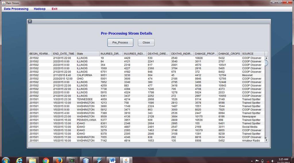
17 DataPreprocessing

18 Analysing of Preprocessed Data as TextFiles

19 Moving data to HDFS server

20 LOCAL STORMS

21 CLUSTER CLASSIFICATION USING SVM
22 HOURLY STORMS
23 OVERALL STORMS

24 ANALYSING OF OVERALL STORMS
25 CONCLUTION The design and implementation a storm classification mechanism using SVM classification The data classification is carried in the map reduce paradigm using Hadoop framework. As the dataset is available in large scale and hence to improve the performance of the cluster scalability, it has been utilized and classify the rainfall data into cluster using the mapper and reduce functions.
26 FUTURE WORK The challenge to proposed system is to guarantee the quality of discovered relevance features in rainfall dataset for describing storm prediction large scale terms and data patterns. Most popular classification methods have adopted term-based approaches suffered from the problems of feature evolution. It discovers rainfall conditions as higher level features and deploys them over low-level features.
27 References K. Jitkajornwanich, R. Elmasri, C. Li, and J. McEnery, Extracting Storm- Centric Characteristics from Raw Rainfall Data for Storm Analysis and Mining, Proceedings of the 1st ACM SIGSPATIALInternational Workshop on Analytics for Big Geospatial Data (ACM SIGSPATIAL BIGSPATIAL 12), 2012, pp K. Jitkajornwanich, U. Gupta, R. Elmasri, L. Fegaras, and J.McEnery, Using MapReduce to Speed Up Storm Identification from Big Raw Rainfall Data, Proceedings of the 4th International Conference on Cloud Computing, GRIDs, and Virtualization (CLOUD COMPUTING 13), 2013, pp J. Dean and S. Ghemawat, MapReduce: Simplified Data Processing on Large Clusters, Proceedings of the 6th Symposium on Operating Systems Design and Implementation (OSDI 04), 2004
28 Continued.. A. Overeem, T. A. Buishand, and I. Holleman, Rainfall Depth-Duration- Frequency Curves and Their Uncertainties, Journal of Hydrology, vol. 348, 2008, pp W. H. Asquith, M. C. Roussel, T. G. Cleveland, X. Fang, and D. B.Thompson, Statistical Characteristics of Storm Interevent Time,Depth, and Duration for Eastern New Mexico, Oklahoma, and Texas, Professional Paper U.S. Geological Survey, W. H. Asquith, Depth-Duration Frequency of Precipitation for Texas, Water-Resources Investigations Report U.S.Geological Survey (USGS), 1998.
29 THANK YOU
USGS ATLAS. BACKGROUND
 USGS ATLAS. BACKGROUND 1998. Asquith. DEPTH-DURATION FREQUENCY OF PRECIPITATION FOR TEXAS. USGS Water-Resources Investigations Report 98 4044. Defines the depth-duration frequency (DDF) of rainfall annual
MapReduce in Spark. Krzysztof Dembczyński. Intelligent Decision Support Systems Laboratory (IDSS) Poznań University of Technology, Poland
 Poznań University of Technology, Poland") MapReduce in Spark Krzysztof Dembczyński Intelligent Decision Support Systems Laboratory (IDSS) Poznań University of Technology, Poland Software Development Technologies Master studies, second semester
MapReduce in Spark Krzysztof Dembczyński Intelligent Decision Support Systems Laboratory (IDSS) Poznań University of Technology, Poland Software Development Technologies Master studies, second semester
ArcGIS GeoAnalytics Server: An Introduction. Sarah Ambrose and Ravi Narayanan
 ArcGIS GeoAnalytics Server: An Introduction Sarah Ambrose and Ravi Narayanan Overview Introduction Demos Analysis Concepts using GeoAnalytics Server GeoAnalytics Data Sources GeoAnalytics Server Administration
LUIZ FERNANDO F. G. DE ASSIS, TÉSSIO NOVACK, KARINE R. FERREIRA, LUBIA VINHAS AND ALEXANDER ZIPF
 A discussion of crowdsourced geographic information initiatives and big Earth observation data architectures for land-use and land-cover change monitoring LUIZ FERNANDO F. G. DE ASSIS, TÉSSIO NOVACK, KARINE
MapReduce in Spark. Krzysztof Dembczyński. Intelligent Decision Support Systems Laboratory (IDSS) Poznań University of Technology, Poland
 Poznań University of Technology, Poland") MapReduce in Spark Krzysztof Dembczyński Intelligent Decision Support Systems Laboratory (IDSS) Poznań University of Technology, Poland Software Development Technologies Master studies, first semester
MapReduce in Spark Krzysztof Dembczyński Intelligent Decision Support Systems Laboratory (IDSS) Poznań University of Technology, Poland Software Development Technologies Master studies, first semester
Spatial Data Science. Soumya K Ghosh
 Workshop on Data Science and Machine Learning (DSML 17) ISI Kolkata, March 28-31, 2017 Spatial Data Science Soumya K Ghosh Professor Department of Computer Science and Engineering Indian Institute of Technology,
The Challenge of Geospatial Big Data Analysis
 288 POSTERS The Challenge of Geospatial Big Data Analysis Authors - Teerayut Horanont, University of Tokyo, Japan - Apichon Witayangkurn, University of Tokyo, Japan - Shibasaki Ryosuke, University of Tokyo,
Query Analyzer for Apache Pig
 Imperial College London Department of Computing Individual Project: Final Report Query Analyzer for Apache Pig Author: Robert Yau Zhou 00734205 (robert.zhou12@imperial.ac.uk) Supervisor: Dr Peter McBrien
CS425: Algorithms for Web Scale Data
 CS425: Algorithms for Web Scale Data Most of the slides are from the Mining of Massive Datasets book. These slides have been modified for CS425. The original slides can be accessed at: www.mmds.org Challenges
CONTEMPORARY ANALYTICAL ECOSYSTEM PATRICK HALL, SAS INSTITUTE
 CONTEMPORARY ANALYTICAL ECOSYSTEM PATRICK HALL, SAS INSTITUTE Copyright 2013, SAS Institute Inc. All rights reserved. Agenda (Optional) History Lesson 2015 Buzzwords Machine Learning for X Citizen Data
STATISTICAL PERFORMANCE
 STATISTICAL PERFORMANCE PROVISIONING AND ENERGY EFFICIENCY IN DISTRIBUTED COMPUTING SYSTEMS Nikzad Babaii Rizvandi 1 Supervisors: Prof.Albert Y.Zomaya Prof. Aruna Seneviratne OUTLINE Introduction Background
International Journal of Scientific & Engineering Research, Volume 7, Issue 2, February ISSN
 International Journal of Scientific & Engineering Research, Volume 7, Issue 2, February-2016 9 Automated Methodology for Context Based Semantic Anomaly Identification in Big Data Hema.R 1, Vidhya.V 2,
CS 347. Parallel and Distributed Data Processing. Spring Notes 11: MapReduce
 CS 347 Parallel and Distributed Data Processing Spring 2016 Notes 11: MapReduce Motivation Distribution makes simple computations complex Communication Load balancing Fault tolerance Not all applications
WDCloud: An End to End System for Large- Scale Watershed Delineation on Cloud
 WDCloud: An End to End System for Large- Scale Watershed Delineation on Cloud * In Kee Kim, * Jacob Steele, + Anthony Castronova, * Jonathan Goodall, and * Marty Humphrey * University of Virginia + Utah
2.6 Complexity Theory for Map-Reduce. Star Joins 2.6. COMPLEXITY THEORY FOR MAP-REDUCE 51
 2.6. COMPLEXITY THEORY FOR MAP-REDUCE 51 Star Joins A common structure for data mining of commercial data is the star join. For example, a chain store like Walmart keeps a fact table whose tuples each
Spatial Analytics Workshop
 Spatial Analytics Workshop Pete Skomoroch, LinkedIn (@peteskomoroch) Kevin Weil, Twitter (@kevinweil) Sean Gorman, FortiusOne (@seangorman) #spatialanalytics Introduction The Rise of Spatial Analytics
Computational Frameworks. MapReduce
 Computational Frameworks MapReduce 1 Computational challenges in data mining Computation-intensive algorithms: e.g., optimization algorithms, graph algorithms Large inputs: e.g., web, social networks data.
A Cloud-Based Flood Warning System For Forecasting Impacts to Transportation Infrastructure Systems
 A Cloud-Based Flood Warning System For Forecasting Impacts to Transportation Infrastructure Systems Jon Goodall Associate Professor, Civil and Environmental Engineering Associate Director, Link Lab April
Hunting for Anomalies in PMU Data
 Hunting for Anomalies in PMU Data BRETT AMIDAN JAMES FOLLUM JEFFERY DAGLE Pacific Northwest National Laboratory NASPI Presentation (October 23, 2014) November 3, 2014 b.amidan@pnnl.gov 1 Big Picture Objective
Scalable 3D Spatial Queries for Analytical Pathology Imaging with MapReduce
 Scalable 3D Spatial Queries for Analytical Pathology Imaging with MapReduce Yanhui Liang, Stony Brook University Hoang Vo, Stony Brook University Ablimit Aji, Hewlett Packard Labs Jun Kong, Emory University
Experiences on Processing Spatial Data with MapReduce *
 Experiences on Processing Spatial Data with MapReduce * Ariel Cary, Zhengguo Sun, Vagelis Hristidis, and Naphtali Rishe Florida International University School of Computing and Information Sciences 11200
A Cloud Computing Workflow for Scalable Integration of Remote Sensing and Social Media Data in Urban Studies
 A Cloud Computing Workflow for Scalable Integration of Remote Sensing and Social Media Data in Urban Studies Aiman Soliman1, Kiumars Soltani1, Junjun Yin1, Balaji Subramaniam2, Pierre Riteau2, Kate Keahey2,
SUMMARY OF DIMENSIONLESS TEXAS HYETOGRAPHS AND DISTRIBUTION OF STORM DEPTH DEVELOPED FOR TEXAS DEPARTMENT OF TRANSPORTATION RESEARCH PROJECT
 U.S. Geological Survey, Austin, Texas Texas Tech University University of Houston Lamar University SUMMARY OF DIMENSIONLESS TEXAS HYETOGRAPHS AND DISTRIBUTION OF STORM DEPTH DEVELOPED FOR TEXAS DEPARTMENT
Visualizing Big Data on Maps: Emerging Tools and Techniques. Ilir Bejleri, Sanjay Ranka
 Visualizing Big Data on Maps: Emerging Tools and Techniques Ilir Bejleri, Sanjay Ranka Topics Web GIS Visualization Big Data GIS Performance Maps in Data Visualization Platforms Next: Web GIS Visualization
TXHYETO.XLS: A Tool To Facilitate Use of Texas- Specific Hyetographs for Design Storm Modeling. Caroline M. Neale Texas Tech University
 TXHYETO.XLS: A Tool To Facilitate Use of Texas- Specific Hyetographs for Design Storm Modeling Caroline M. Neale Texas Tech University Acknowledgements Funding and direction provided by the Texas Department
Large-Scale Behavioral Targeting
 Large-Scale Behavioral Targeting Ye Chen, Dmitry Pavlov, John Canny ebay, Yandex, UC Berkeley (This work was conducted at Yahoo! Labs.) June 30, 2009 Chen et al. (KDD 09) Large-Scale Behavioral Targeting
Computational Frameworks. MapReduce
 Computational Frameworks MapReduce 1 Computational complexity: Big data challenges Any processing requiring a superlinear number of operations may easily turn out unfeasible. If input size is really huge,
4. GIS Implementation of the TxDOT Hydrology Extensions
 4. GIS Implementation of the TxDOT Hydrology Extensions A Geographic Information System (GIS) is a computer-assisted system for the capture, storage, retrieval, analysis and display of spatial data. It
DUG User Guide. Version 2.1. Aneta J Florczyk Luca Maffenini Martino Pesaresi Thomas Kemper
 DUG User Guide Version 2.1 Aneta J Florczyk Luca Maffenini Martino Pesaresi Thomas Kemper 2017 i This publication is a Technical report by the Joint Research Centre (JRC), the European Commission s science
Distributed Architectures
 Distributed Architectures Software Architecture VO/KU (707023/707024) Roman Kern KTI, TU Graz 2015-01-21 Roman Kern (KTI, TU Graz) Distributed Architectures 2015-01-21 1 / 64 Outline 1 Introduction 2 Independent
Synergie PC Updates and Plans. A. Lasserre-Bigorry, B. Benech M-F Voidrot, & R. Giraud
 Synergie PC Updates and Plans A. Lasserre-Bigorry, B. Benech M-F Voidrot, & R. Giraud 1 2 3 4 Introduction Migration to PC-Linux Synergie 4.0 features Perspectives for 2006 ECMWF 10 th Workshop on Meteorological
Real-Time Big Data Analytical Architecture for Remoting Sensing Application
 Real-Time Big Data Analytical Architecture for Remoting Sensing Application Author: M. M. U. Rathore, A. Paul, A. Ahmad, B.-W. Chen, B. Hunag and W. Ji Presenter: Junyi Shen Big Data High speed continuous
Basics of GIS reviewed
 Basics of GIS reviewed Martin Breunig Karlsruhe Institute of Technology martin.breunig@kit.edu GEODETIC INSTITUTE, DEPARTMENT OF CIVIL ENGINEERING, GEO AND ENVIRONMENTAL SCIENCES, CHAIR IN GEOINFORMATICS
RESEARCH ON THE DISTRIBUTED PARALLEL SPATIAL INDEXING SCHEMA BASED ON R-TREE
 RESEARCH ON THE DISTRIBUTED PARALLEL SPATIAL INDEXING SCHEMA BASED ON R-TREE Yuan-chun Zhao a, b, Cheng-ming Li b a. Shandong University of Science and Technology, Qingdao 266510 b. Chinese Academy of
Spatial Data Management of Bio Regional Assessments Phase 1 for Coal Seam Gas Challenges and Opportunities
 Spatial Data Management of Bio Regional Assessments Phase 1 for Coal Seam Gas Challenges and Opportunities By Dr Zaffar Sadiq Mohamed-Ghouse Principal Consultant, Spatial & IT, GHD zaffar.sadiq@ghd.com
Project 2: Hadoop PageRank Cloud Computing Spring 2017
 Project 2: Hadoop PageRank Cloud Computing Spring 2017 Professor Judy Qiu Goal This assignment provides an illustration of PageRank algorithms and Hadoop. You will then blend these applications by implementing
Proposal to Include a Grid Referencing System in S-100
 1 st IHO-HSSC Meeting The Regent Hotel, Singapore, 22-24 October 2009 Paper for consideration by HSSC Proposal to Include a Grid Referencing System in S-100 Submitted by: Executive Summary: Related Documents:
Predictive Analytics on Accident Data Using Rule Based and Discriminative Classifiers
 Advances in Computational Sciences and Technology ISSN 0973-6107 Volume 10, Number 3 (2017) pp. 461-469 Research India Publications http://www.ripublication.com Predictive Analytics on Accident Data Using
State of GIS at the High Performance Computing Cluster
 State of GIS at the High Performance Computing Cluster Peter Löwe, Jan Thaler, Stefan Lüdtke² Centre for GeoInformation Technology (CeGIT) ² Section 5.4 (Hydrology) Computing Clusters A set of loosely
V.4 MapReduce. 1. System Architecture 2. Programming Model 3. Hadoop. Based on MRS Chapter 4 and RU Chapter 2 IR&DM 13/ 14 !74
 V.4 MapReduce. System Architecture 2. Programming Model 3. Hadoop Based on MRS Chapter 4 and RU Chapter 2!74 Why MapReduce? Large clusters of commodity computers (as opposed to few supercomputers) Challenges:
Technical Report Documentation Page
 NOTICE The United States Government and the State of Texas do not endorse products or manufacturers. Trade or manufacturers names appear herein solely because they are considered essential to the object
Scalable and Power-Efficient Data Mining Kernels
 Scalable and Power-Efficient Data Mining Kernels Alok Choudhary, John G. Searle Professor Dept. of Electrical Engineering and Computer Science and Professor, Kellogg School of Management Director of the
CWMS Modeling for Real-Time Water Management
 Hydrologic Engineering Center Training Course on CWMS Modeling for Real-Time Water Management August 2018 Davis, California The Corps Water Management System (CWMS) is a software and hardware system to
Tall-and-skinny! QRs and SVDs in MapReduce
 A 1 A 2 A 3 Tall-and-skinny! QRs and SVDs in MapReduce Yangyang Hou " Purdue, CS Austin Benson " Stanford University Paul G. Constantine Col. School. Mines " Joe Nichols U. of Minn James Demmel " UC Berkeley
ArcGIS Enterprise: What s New. Philip Heede Shannon Kalisky Melanie Summers Sam Williamson
 ArcGIS Enterprise: What s New Philip Heede Shannon Kalisky Melanie Summers Sam Williamson ArcGIS Enterprise is the new name for ArcGIS for Server What is ArcGIS Enterprise ArcGIS Enterprise is powerful
Real-Time Meteorological Gridded Data: What s New With HEC-RAS
 Real-Time Meteorological Gridded Data: What s New With HEC-RAS Acquisition and Application of Gridded Meteorological Data in Support of the USACE s Real-Time Water Management Mission Fauwaz Hanbali, Tom
DP Project Development Pvt. Ltd.
 Dear Sir/Madam, Greetings!!! Thanks for contacting DP Project Development for your training requirement. DP Project Development is leading professional training provider in GIS technologies and GIS application
Marla Meehl Manager of NCAR/UCAR Networking and Front Range GigaPoP (FRGP)
") Big Data at the National Center for Atmospheric Research (NCAR) & expanding network bandwidth to NCAR over Pacific Wave and Western Regional Network (WRN) Marla Meehl Manager of NCAR/UCAR Networking and
Big Data at the National Center for Atmospheric Research (NCAR) & expanding network bandwidth to NCAR over Pacific Wave and Western Regional Network (WRN) Marla Meehl Manager of NCAR/UCAR Networking and
A Spatial Data Infrastructure for Landslides and Floods in Italy
 V Convegno Nazionale del Gruppo GIT Grottaminarda 14 16 giugno 2010 A Spatial Data Infrastructure for Landslides and Floods in Italy Ivan Marchesini, Vinicio Balducci, Gabriele Tonelli, Mauro Rossi, Fausto
Large Scale Evaluation of Chemical Structure Recognition 4 th Text Mining Symposium in Life Sciences October 10, Dr.
 Large Scale Evaluation of Chemical Structure Recognition 4 th Text Mining Symposium in Life Sciences October 10, 2006 Dr. Overview Brief introduction Chemical Structure Recognition (chemocr) Manual conversion
Unsupervised Anomaly Detection for High Dimensional Data
 Unsupervised Anomaly Detection for High Dimensional Data Department of Mathematics, Rowan University. July 19th, 2013 International Workshop in Sequential Methodologies (IWSM-2013) Outline of Talk Motivation
Discovering Spatial and Temporal Links among RDF Data Panayiotis Smeros and Manolis Koubarakis
 Discovering Spatial and Temporal Links among RDF Data Panayiotis Smeros and Manolis Koubarakis WWW2016 Workshop: Linked Data on the Web (LDOW2016) April 12, 2016 - Montréal, Canada Outline Introduction
Leon Creek Watershed October 17-18, 1998 Rainfall Analysis Examination of USGS Gauge Helotes Creek at Helotes, Texas
 Leon Creek Watershed October 17-18, 1998 Rainfall Analysis Examination of USGS Gauge 8181400 Helotes Creek at Helotes, Texas Terrance Jackson MSCE Candidate University of Texas San Antonio Abstract The
Automated Storm-based Scheduling on the National Weather Radar Testbed Phased Array Radar
 P41 Automated Storm-based Scheduling on the National Weather Radar Testbed Phased Array Radar David L. Priegnitz Cooperative Institute for Mesoscale Meteorological Studies, University of Oklahoma, Norman,
Harvard Center for Geographic Analysis Geospatial on the MOC
 2017 Massachusetts Open Cloud Workshop Boston University Harvard Center for Geographic Analysis Geospatial on the MOC Ben Lewis Harvard Center for Geographic Analysis Aaron Williams MapD Small Team Supporting
Environment Change Prediction to Adapt Climate- Smart Agriculture Using Big Data Analytics
 Environment Change Prediction to Adapt Climate- Smart Agriculture Using Big Data Analytics Ramya M G PG Student Dept of CSE, Cit, Gubbi, Tumkur, India Chetan Balaji Assistant Professor, Dept of CSE, Cit,
Electrical thunderstorm nowcasting using lightning data mining
 Data Mining VII: Data, Text and Web Mining and their Business Applications 161 Electrical thunderstorm nowcasting using lightning data mining C. A. M. Vasconcellos 1, C. L. Curotto 2, C. Benetti 1, F.
INTRODUCTION TO GEOGRAPHIC INFORMATION SYSTEM By Reshma H. Patil
 INTRODUCTION TO GEOGRAPHIC INFORMATION SYSTEM By Reshma H. Patil ABSTRACT:- The geographical information system (GIS) is Computer system for capturing, storing, querying analyzing, and displaying geospatial
Big Data Analytics. Lucas Rego Drumond
 Lucas Rego Drumond Information Systems and Machine Learning Lab (ISMLL) Institute of Computer Science University of Hildesheim, Germany Map Reduce I Map Reduce I 1 / 32 Outline 1. Introduction 2. Parallel
Clustering algorithms distributed over a Cloud Computing Platform.
 Clustering algorithms distributed over a Cloud Computing Platform. SEPTEMBER 28 TH 2012 Ph. D. thesis supervised by Pr. Fabrice Rossi. Matthieu Durut (Telecom/Lokad) 1 / 55 Outline. 1 Introduction to Cloud
Orbital Insight Energy: Oil Storage v5.1 Methodologies & Data Documentation
 Orbital Insight Energy: Oil Storage v5.1 Methodologies & Data Documentation Overview and Summary Orbital Insight Global Oil Storage leverages commercial satellite imagery, proprietary computer vision algorithms,
Energy-efficient Mapping of Big Data Workflows under Deadline Constraints
 Energy-efficient Mapping of Big Data Workflows under Deadline Constraints Presenter: Tong Shu Authors: Tong Shu and Prof. Chase Q. Wu Big Data Center Department of Computer Science New Jersey Institute
ZFL, Center of Remote Sensing of Land Surfaces, University of Bonn, Germany. Geographical Institute, University of Bonn, Germany
 Communication of Research Results The IMPETUS Atlas H.-P. Thamm 1, M. Judex 1, O.Schultz 2, S.Krüger 1 & M. Christoph 3 1 ZFL, Center of Remote Sensing of Land Surfaces, University of Bonn, Germany 2 Geographical
How to make R, PostGIS and QGis cooperate for statistical modelling duties: a case study on hedonic regressions
 How to make R, PostGIS and QGis cooperate for statistical modelling duties: a case study on hedonic regressions Olivier Bonin To cite this version: Olivier Bonin. How to make R, PostGIS and QGis cooperate
An Optimized Interestingness Hotspot Discovery Framework for Large Gridded Spatio-temporal Datasets
 IEEE Big Data 2015 Big Data in Geosciences Workshop An Optimized Interestingness Hotspot Discovery Framework for Large Gridded Spatio-temporal Datasets Fatih Akdag and Christoph F. Eick Department of Computer
Performance Evaluation of the Matlab PCT for Parallel Implementations of Nonnegative Tensor Factorization
 Performance Evaluation of the Matlab PCT for Parallel Implementations of Nonnegative Tensor Factorization Tabitha Samuel, Master s Candidate Dr. Michael W. Berry, Major Professor Abstract: Increasingly
Imagery and the Location-enabled Platform in State and Local Government
 Imagery and the Location-enabled Platform in State and Local Government Fred Limp, Director, CAST Jim Farley, Vice President, Leica Geosystems Oracle Spatial Users Group Denver, March 10, 2005 TM TM Discussion
Extending the use of Flood Modeller Pro towards operational forecasting with Delft-FEWS
 Extending the use of Flood Modeller Pro towards operational forecasting with Delft-FEWS Simone van Schijndel, Department Head Operational Water Management and Early Warning Intentionally blank The world
GIS (GEOGRAPHIC INFORMATION SYSTEMS)
") GIS (GEOGRAPHIC INFORMATION SYSTEMS) 1 1. DEFINITION SYSTEM Any organised assembly of resources and procedures united and regulated by interaction or interdependence to complete a set of specific functions.
GIS (GEOGRAPHIC INFORMATION SYSTEMS) 1 1. DEFINITION SYSTEM Any organised assembly of resources and procedures united and regulated by interaction or interdependence to complete a set of specific functions.
Development of a GIS Interface for WEPP Model Application to Great Lakes Forested Watersheds
 Development of a GIS Interface for WEPP Model Application to Great Lakes Forested Watersheds J.R. Frankenberger 1, S. Dun 2, D.C. Flanagan 1, J.Q. Wu 2, W.J. Elliot 3 1 USDA-ARS, West Lafayette, IN 2 Washington
CS224W: Methods of Parallelized Kronecker Graph Generation
 CS224W: Methods of Parallelized Kronecker Graph Generation Sean Choi, Group 35 December 10th, 2012 1 Introduction The question of generating realistic graphs has always been a topic of huge interests.
AN INTERNATIONAL SOLAR IRRADIANCE DATA INGEST SYSTEM FOR FORECASTING SOLAR POWER AND AGRICULTURAL CROP YIELDS
 AN INTERNATIONAL SOLAR IRRADIANCE DATA INGEST SYSTEM FOR FORECASTING SOLAR POWER AND AGRICULTURAL CROP YIELDS James Hall JHTech PO Box 877 Divide, CO 80814 Email: jameshall@jhtech.com Jeffrey Hall JHTech
Research Collection. JSONiq on Spark. Master Thesis. ETH Library. Author(s): Irimescu, Stefan. Publication Date: 2018
: Irimescu, Stefan. Publication Date: 2018") Research Collection Master Thesis JSONiq on Spark Author(s): Irimescu, Stefan Publication Date: 2018 Permanent Link: https://doi.org/10.3929/ethz-b-000272416 Rights / License: In Copyright - Non-Commercial
Research Collection Master Thesis JSONiq on Spark Author(s): Irimescu, Stefan Publication Date: 2018 Permanent Link: https://doi.org/10.3929/ethz-b-000272416 Rights / License: In Copyright - Non-Commercial
A REVIEW ON SPATIAL DATA AND SPATIAL HADOOP
 International Journal of Latest Trends in Engineering and Technology Vol.(8)Issue(1), pp.545-550 DOI: http://dx.doi.org/10.21172/1.81.071 e-issn:2278-621x A REVIEW ON SPATIAL DATA AND SPATIAL HADOOP Kirandeep
Advanced Computing Systems for Scientific Research
 Undergraduate Review Volume 10 Article 13 2014 Advanced Computing Systems for Scientific Research Jared Buckley Jason Covert Talia Martin Recommended Citation Buckley, Jared; Covert, Jason; and Martin,
Internet Engineering Jacek Mazurkiewicz, PhD
 Internet Engineering Jacek Mazurkiewicz, PhD Softcomputing Part 11: SoftComputing Used for Big Data Problems Agenda Climate Changes Prediction System Based on Weather Big Data Visualisation Natural Language
Anomaly Detection for the CERN Large Hadron Collider injection magnets
 Anomaly Detection for the CERN Large Hadron Collider injection magnets Armin Halilovic KU Leuven - Department of Computer Science In cooperation with CERN 2018-07-27 0 Outline 1 Context 2 Data 3 Preprocessing
Handling Uncertainty in Clustering Art-exhibition Visiting Styles
 Handling Uncertainty in Clustering Art-exhibition Visiting Styles 1 joint work with Francesco Gullo 2 and Andrea Tagarelli 3 Salvatore Cuomo 4, Pasquale De Michele 4, Francesco Piccialli 4 1 DTE-ICT-HPC
Rick Ebert & Joseph Mazzarella For the NED Team. Big Data Task Force NASA, Ames Research Center 2016 September 28-30
 NED Mission: Provide a comprehensive, reliable and easy-to-use synthesis of multi-wavelength data from NASA missions, published catalogs, and the refereed literature, to enhance and enable astrophysical
INTRODUCTION TO GIS. Dr. Ori Gudes
 INTRODUCTION TO GIS Dr. Ori Gudes Outline of the Presentation What is GIS? What s the rational for using GIS, and how GIS can be used to solve problems? Explore a GIS map and get information about map
The GeoCLIM software for gridding & analyzing precipitation & temperature. Tamuka Magadzire, FEWS NET Regional Scientist for Southern Africa
 The GeoCLIM software for gridding & analyzing precipitation & temperature Tamuka Magadzire, FEWS NET Regional Scientist for Southern Africa Outline What is GeoCLIM GeoCLIM Development Team GeoCLIM: objectives
RADAR Rainfall Calibration of Flood Models The Future for Catchment Hydrology? A Case Study of the Stanley River catchment in Moreton Bay, Qld
 RADAR Rainfall Calibration of Flood Models The Future for Catchment Hydrology? A Case Study of the Stanley River catchment in Moreton Bay, Qld A 1 Principal Engineer, Water Technology Pty Ltd, Brisbane,
GIS Visualization: A Library s Pursuit Towards Creative and Innovative Research
 GIS Visualization: A Library s Pursuit Towards Creative and Innovative Research Justin B. Sorensen J. Willard Marriott Library University of Utah justin.sorensen@utah.edu Abstract As emerging technologies
Exploring Human Mobility with Multi-Source Data at Extremely Large Metropolitan Scales. ACM MobiCom 2014, Maui, HI
 Exploring Human Mobility with Multi-Source Data at Extremely Large Metropolitan Scales Desheng Zhang & Tian He University of Minnesota, USA Jun Huang, Ye Li, Fan Zhang, Chengzhong Xu Shenzhen Institute
Innovation. The Push and Pull at ESRI. September Kevin Daugherty Cadastral/Land Records Industry Solutions Manager
 Innovation The Push and Pull at ESRI September 2004 Kevin Daugherty Cadastral/Land Records Industry Solutions Manager The Push and The Pull The Push is the information technology that drives research and
BCN: Expansible Network Structures for Data Centers Using Hierarchical Compound Graphs
 This paper was presented as part of the Mini-Conference at IEEE INFOCOM 011 BCN: Expansible Network Structures for Data Centers Using Hierarchical Compound Graphs Deke Guo, Tao Chen, Dan Li, Yunhao Liu,
Near Real-Time Runoff Estimation Using Spatially Distributed Radar Rainfall Data. Jennifer Hadley 22 April 2003
 Near Real-Time Runoff Estimation Using Spatially Distributed Radar Rainfall Data Jennifer Hadley 22 April 2003 Introduction Water availability has become a major issue in Texas in the last several years,
DANIEL WILSON AND BEN CONKLIN. Integrating AI with Foundation Intelligence for Actionable Intelligence
 DANIEL WILSON AND BEN CONKLIN Integrating AI with Foundation Intelligence for Actionable Intelligence INTEGRATING AI WITH FOUNDATION INTELLIGENCE FOR ACTIONABLE INTELLIGENCE in an arms race for artificial
ENV208/ENV508 Applied GIS. Week 1: What is GIS?
 ENV208/ENV508 Applied GIS Week 1: What is GIS? 1 WHAT IS GIS? A GIS integrates hardware, software, and data for capturing, managing, analyzing, and displaying all forms of geographically referenced information.
Deep Learning. Convolutional Neural Networks Applications
 Deep Learning Using a Convolutional Neural Network Dr. Ing. Morris Riedel Adjunct Associated Professor School of Engineering and Natural Sciences, University of Iceland Research Group Leader, Juelich Supercomputing
A Comparative Study of the National Water Model Forecast to Observed Streamflow Data
 A Comparative Study of the National Water Model Forecast to Observed Streamflow Data CE394K GIS in Water Resources Term Project Report Fall 2018 Leah Huling Introduction As global temperatures increase,
ArcGIS Enterprise: What s New. Philip Heede Shannon Kalisky Melanie Summers Shreyas Shinde
 ArcGIS Enterprise: What s New Philip Heede Shannon Kalisky Melanie Summers Shreyas Shinde ArcGIS Enterprise is the new name for ArcGIS for Server ArcGIS Enterprise Software Components ArcGIS Server Portal
Using R for Iterative and Incremental Processing
 Using R for Iterative and Incremental Processing Shivaram Venkataraman, Indrajit Roy, Alvin AuYoung, Robert Schreiber UC Berkeley and HP Labs UC BERKELEY Big Data, Complex Algorithms PageRank (Dominant
DATA SOURCES AND INPUT IN GIS. By Prof. A. Balasubramanian Centre for Advanced Studies in Earth Science, University of Mysore, Mysore
 DATA SOURCES AND INPUT IN GIS By Prof. A. Balasubramanian Centre for Advanced Studies in Earth Science, University of Mysore, Mysore 1 1. GIS stands for 'Geographic Information System'. It is a computer-based
Hierarchical models for the rainfall forecast DATA MINING APPROACH
 Hierarchical models for the rainfall forecast DATA MINING APPROACH Thanh-Nghi Do dtnghi@cit.ctu.edu.vn June - 2014 Introduction Problem large scale GCM small scale models Aim Statistical downscaling local
Large Alberta Storms. March Introduction
 Large Alberta Storms Introduction Most of the largest runoff events in Alberta have been in response to large storms. Storm properties, such as location, magnitude, and geographic and temporal distribution
gvsig: Open Source Solutions in spatial technologies
 gvsig: Open Source Solutions in spatial technologies gvsig is a tool for handling geographical information, a completely GIS client with license GNU GPL. Alvaro A. Anguix Alfaro, Gabriel Carrión Rico Conselleria
Climpact2 and PRECIS
 Climpact2 and PRECIS WMO Workshop on Enhancing Climate Indices for Sector-specific Applications in the South Asia region Indian Institute of Tropical Meteorology Pune, India, 3-7 October 2016 David Hein-Griggs
Uncertainty Quantification in Performance Evaluation of Manufacturing Processes
 Uncertainty Quantification in Performance Evaluation of Manufacturing Processes Manufacturing Systems October 27, 2014 Saideep Nannapaneni, Sankaran Mahadevan Vanderbilt University, Nashville, TN Acknowledgement
5A.10 A GEOSPATIAL DATABASE AND CLIMATOLOGY OF SEVERE WEATHER DATA
 5A.10 A GEOSPATIAL DATABASE AND CLIMATOLOGY OF SEVERE WEATHER DATA Steve Ansari * and Stephen Del Greco NOAA National Climatic Data Center, Asheville, North Carolina Mark Phillips University of North Carolina