Part 9. Tropical Cyclones
|
|
|
- Penelope Turner
- 6 years ago
- Views:
Transcription
1 Part 9. Tropical Cyclones 9.1 Introduction The tropical cyclone is known as the hurricane in the north Atlantic and eastern north Pacific, typhoon in the western north Pacific, and just cyclone in the Indian ocean and Australia. One of the more colorful names it has been given is The Serpent's Coil 1, a very appropriate name because from its coiled position the tropical cyclone strikes with a vengeance with winds in excess of 32 m/s (64 mi/hr), heavy rainfall, storm surges, and sporadic tornadoes. Born over warm, tropical, oceanic waters, the storm gains strength as it moves poleward and spins up into a cyclonically-rotating storm (counter-clockwise in the northern hemisphere) as it experiences the influence of the earth's rotation. At its maturity, the tropical cyclone is an inertially stable vortex whose circulations may extend to distances as much as 1600 km (890 mi) from the storm center. The highest sustained winds ever recorded in an Atlantic tropical cyclone occurred in Gilbert were 82.3 m/s (184 mi/hr) with a top gust measured at 199 mi/hr. Not only do tropical cyclones produce winds that can rival a tornado in strength, but also they can produce extensive damage over large areas and for sustained periods. 9.2 Structure of the Mature Tropical Cyclone A schematic of the three-dimensional structure of a mature tropical cyclone is shown in Figure Farley Mowat, 1985: The Serpent's Coil. Seal Books, McClelland and Stewart-Bantam Books, 222 pp. 331
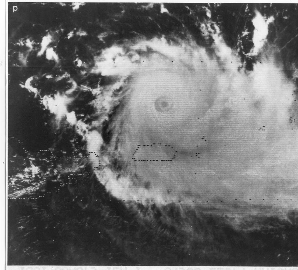
2 Figure 9.1. Schematic diagram of hurricane, showing low-level circulation and cloud types. The highest clouds, composed of cirrus and cirrostratus, occur at the tropopause, which is about 16 km. (From Stormfury, 1970: Project Stormfury Annual Report 1969, National Hurricane Research Laboratory, NOAA, AOML/Hurricane Research Division, Miami, FL, 20 pp.) Near the surface, warm, moist air spirals inward toward the center of low pressure. At radii greater than about 400 to 600 km from the center, this flow is divergent, and sinking motion extends throughout most of the troposphere. This warm, sinking air is dry and usually is free of deep convective clouds, as seen in the satellite photograph of Hurricane Becky, which occurred in 1974 (Figure 9.2). Inside a radius of about 400 km, the low-level flow is convergent and the associated lifting of the warm, humid air produces extensive cumulonimbus clouds and precipitation. In spite of the relatively uniform tropical environment in which the tropical cyclone develops, it is characterized by a number of important mesoscale features. The mesoscale structure consists of the eyewall, a generally circular ring of intense convection surrounding the often cloud free eye; a region of stratiform cloud 332
 and precipitation outside the eyewall; and spiral bands of convective clouds that assume various forms.")
3 Figure 9.2. Satellite photograph of Hurricane Becky, 1800 UTC 20 August (Anthes, R. A., 1982: Tropical cyclones. Their evolution, structure, and effects. Meteor. Monograph No. 41, American Meteorological Society, Boston, 208 pp.) and precipitation outside the eyewall; and spiral bands of convective clouds that assume various forms. Visible and infrared satellite imagery of four mature hurricanes shown in Figure 9.3 all show well-developed eyes and bands of clouds having variable structure. 333


4 334
 GOES-2 visible view of Hurricane Anita at 2300 UTC 1 September 1977 in the western Gulf of")
 SMS-2 visible picture of Hurricane Frederic at 1300 UTC 12 September 1979 south of Mobile, Alabama. (d) SMS-2 IR view of Hurricane Allen at 1430 UTC 5 August 1980 south of Hispaniola.")
5 Figure 9.3. Satellite imagery of the four hurricanes near the time of flights by the research aircraft: (a) GOES-2 visible view of Hurricane Anita at 2300 UTC 1 September 1977 in the western Gulf of Mexico. (b) SMS-2 IR picture of Hurricane David at 1530 UTC 30 August 1979 south of Puerto Rico. (c) SMS-2 visible picture of Hurricane Frederic at 1300 UTC 12 September 1979 south of Mobile, Alabama. (d) SMS-2 IR view of Hurricane Allen at 1430 UTC 5 August 1980 south of Hispaniola. (e) TIROS-N visible image of Hurricane Allen at 2115 UTC 8 August 1980 in the central Gulf of Mexico. (From Jorgensen, D. P., 1984a: Mesoscale and convective-scale characteristics of mature hurricanes. Part I. General observations by research aircraft. J. Atmos. Sci., 41, ) 335

6 A schematic radar vertical cross section through the eyewall region is illustrated in Figure 9.4. The eye is depicted by generally sinking motions Figure 9.4. Schematic cross section depicting the locations of the clouds and precipitation, RMW, and radial-vertical airflow through the eyewall of Hurricane Allen on 5 August The slope of the cloudy region on the inside edge of the eyewall is based on radar minimum detectable signal analysis, aircraft altimeter readings, hand photography and observer notes. Darker shaded regions denote the location of the largest radial and vertical velocity. (From Jorgensen, D. P., 1984b: Mesoscale and convective-scale characteristics of mature hurricanes. Part II. Inner core structure of hurricane Allen. J. Atmos. Sci., 41, ) 336
7 Figure 9.5. A horizontal radar depiction of rainbands. Low-level flow is also shown. (From Barnes, G. M., E. J. Zipser, D. Jorgensen and F. Marks, Jr., 1983: Mesoscale and convective structure of a hurricane rainband. J. Atmos. Sci., 40, ) and is relatively cloud-free except for some low cumulus clouds and thin middle level cumulus clouds. Between 30 and 35 km outward from the center of the eye is the eyewall that is characterized by rapid ascent of the air rushing in toward the storm center. The eyewall tilts radially outward with height at an angle of about 30 degrees from the horizontal and, along with it, so also does the radius of maximum winds (RMW). The strongest radar reflectivity is located several kilometers outside the radius of maximum winds, while the maximum updrafts lie several kilometers inward of the RMW. The region beyond the eyewall cloud is characterized by stratiform cloud and precipitation. The local regions of high radar reflectivity called 337
8 bright bands, near 5 km height and outward from 45 km are due to melting of stratiform precipitation. Beyond the eyewall region, the predominant mesoscale features of the tropical cyclone are spiral bands of clouds and rainfall. The rainbands are typically 5 to 50 km wide and spiral inward toward the center over radial distances of 100 to 300 km. Cumulus clouds tend to form on the inside of the bands and move cyclonically (counter-clockwise in the northern hemisphere) around the storm center. The convective elements typically move outward from the storm's central regions during the formative stage of the storm and dissipate further away from the storm center. The bands can be classified as two types: propagating, wavelike bands associated with internal gravity waves and groups of bands that remain in a nearly fixed location relative to the storm center. Figure 9.5 illustrates two rainbands as seen by radar outward from the eyewall. Like a giant flywheel, the region within 100 km of the storm center is inertially stable and is not affected strongly by outside weather systems. At distances of 100 km to more than 1000 km from the storm center, the flow is not so inertially stable and larger-scale weather systems can easily affect the airflow in these regions. At these distances from the storm center, the flow is largely in gradient wind balance but approaches geostrophic balance at the outer cyclone limits. The dimensions of tropical cyclones mentioned above are fairly typical. It must be recognized, however, there is enormous variability in the size of tropical cyclones with some smaller storms being able to fit within the eye of the largest storm. 9.3 Energetics of the Mature Storm The primary energy driving the tropical cyclone comes from the sea. Air flowing over a warm ocean surface receives energy from the surface primarily in two forms: sensible heat and latent heat. The transfer of sensible heat from the ocean surface refers to the direct transfer of heat from the warm ocean surface to cooler overlying air by small-scale turbulent eddies. The rate of transfer of heat from the ocean surface is greater the larger the temperature difference between the ocean surface and the overlying air and the stronger the wind speed near the ocean surface. The transfer of latent heat from the ocean surface refers to the moistening of the air near the ocean surface by evaporation of seawater. In 338
9 general, the rate of latent heat transfer by evaporation from the ocean surface increases as the temperature of the ocean surface is warmed and, as with sensible heat, with the wind speed. The energy required to evaporate seawater comes from the ocean itself, which is a large heat reservoir. Thus, moisture is supplied to the air immediately over the ocean surface without any substantial cooling of the air. As shown in Figure 9.6, as low-level air is swept inward towards the center of the cyclone, it collects sensible and latent heat from the ocean surface at increasingly large rates because the wind speed increases toward the eyewall region. Figure 9.6. Illustration of sensible (S) and latent heat fluxes (LQ) from the ocean surface beneath a tropical cyclone. As winds increase in speed toward the central region of the cyclone, fluxes of sensible and latent heat increase substantially. Cumulus clouds and sub-cloud eddies transfer the heat supplied by the ocean surface upwards to the middle and upper troposphere. In the upper troposphere and lower stratosphere heat is lost to space by longwave radiation emissions (R) from the tops of the stratiform-anvil clouds.} Small-scale turbulent eddies transfer the heat and moisture upwards to levels where it becomes saturated and cumulus clouds form. By condensing water to form cloud droplets and as a consequence releasing latent heat, the moisture or latent heat transferred from the ocean surface warms the cloudy air at a rate, which is roughly proportional to the precipitation rate in the clouds. Thus, cumulus clouds and sub-cloud eddies transfer the sensible and latent heat from the ocean surface to the middle and upper troposphere. As the air moves outward from the central regions of the storm in the 339
10 stratiform-anvil clouds, much of the energy gained at the ocean surface is radiated to space by infrared radiation. Emanuel 2 has likened the tropical cyclone to an idealized heat engine, called a Carnot engine, which is very efficient in converting heat into work or kinetic energy of motion (in this case winds). In a Carnot engine, heat is input at a single high temperature and all the heat output is ejected at a single low temperature. The amount of work produced by the Carnot engine is proportional to the difference between the input and output temperatures, and is the maximum amount of energy that can be extracted from a heat source. In the case of a tropical cyclone, the amount of work or strength of the winds in a storm is proportional to the difference in temperature between the heat input level or the ocean surface and the heat output level, or the tops of the anvil clouds. In the case of the Carnot engine, heat input is in the form of sensible heat, while in a tropical cyclone, heat input is in the form of sensible and latent heat, with latent heat being the dominant contributor to the storm energetics. The tropical cyclone can thus be viewed as a heat engine, although less efficient than the idealized Carnot engine. Figure 9.7 shows that tropical cyclones do indeed increase in strength as sea surface temperature increases. 2 Emanuel, Kerry A., 1988: Toward a general theory of hurricanes. American Scientist, 76,
11 Figure 9.7. Empirical relationship between climatological sea surface temperature (SST) and best track for a sample of hurricanes. Small numbers are the frequencies of occurrence of a given intensity and SST, and the dashed line is the empirically determined upper bound on hurricane intensity. (From Merrill, R.T., 1988: Environmental influences on hurricane intensification. J. Atmos. Sci., 45, ) Another energy source for a tropical cyclone is a result of the cooperative interaction between deep convective cells and the cyclone circulation. We have seen from preceeding chapters that low-level convergence of warm, moist air is necessary for maintaining cumulonimbus cells. We have also seen that above the boundary layer, flow about a low pressure center can approach gradient wind balance, in which the horizontal pressure gradient force is balanced by the sum of the Coriolis and centrifugal forces. Within the boundary layer, friction slows down the winds and the flow about a low pressure center adjusts to a new balance of forces in 341
12 which the flow turns toward low pressure. The turning of the winds toward low pressure in the boundary layer causes convergence called Ekman convergence. In a tropical cyclone, the frictionally-induced convergence can supply cumulus clouds with warm, moist air. The warm, moist air could either be resident at low levels in the cyclone environment or it could be transferred from the ocean surface as described above. Fed by the supply of warm moist air, deep, precipitating convective clouds develop, which release latent heat and warm the air in the cloudy regions. The column of warmed air lowers the pressure at low-levels in the storm, which in turn favors the development of increased boundary layer convergence. This, then fires up more intense convection, and so on. This process is referred to as conditional instability of the second kind (CISK). (Conditional instability of the first kind refers to free parcel.) A schematic illustrating the development of a tropical cyclone from an environment characterized by a weak, low-level cyclone and upperlevel anticyclone is shown in Figure 9.8. Figure 9.8. Schematic depiction of CISK. Initially there is an anticyclone aloft and a cyclone in the lower troposphere. Ekman convergence in the 342
13 boundary layer provides moisture to a population of precipitating clouds. Most of the diabatic heat source is balanced by the adiabatic cooling associated with the induced transverse circulation. However, there is a slight warming, yielding a more intense anticyclone aloft, a more intense cyclone below, increased Ekman convergence, more clouds, etc. (Adapted from Schubert, W.H. and J.J. Hack, 1982: Inertial stability and tropical cyclone development. J. Atmos. Sci., 39, ) Scientists are still debating whether a tropical cyclone is driven primarily by a CISK-type process or by a Carnot engine-type process or perhaps some other processes. There is strong evidence that the strength of tropical cyclones and the intensity of the surface low pressure cannot be achieved by a CISK mechanism alone. Boundary layer fluxes of heat and moisture are necessary for maintenance and perhaps intensification of an incipient cyclonic storm to hurricane strength. Moreover the presence of large numbers of cumulonimbus clouds in the tropics drives the tropical cyclone environment to near wet adiabatic in structure and as a result there is little conditional instability to drive a strong CISK mechanism. On the other hand, large regions of the tropical ocean exhibit sea surface temperatures high enough to sustain a tropical cyclone by a Carnot cycle-type process alone, yet few, if any, tropical cyclones form. This means that some other factors must come into place to create a storm of hurricane intensity. 9.4 Genesis of Tropical Cyclones There are favored regions on the earth for tropical cyclone genesis. Figure 9.9 illustrates they are in the western Atlantic, eastern Pacific, 343
14 Figure 9.9. Locations of the regions of genesis of tropical cyclones for a 20-year period. (Gray, W.H., 1975: Tropical cyclone genesis. Dept. of Atmos. Sci.Paper No. 234, Colorado State University, Dept. of Atmospheric Science, Fort Collins, CO ) western North Pacific, North Indian Ocean, South Indian Ocean, in northern Australia and the South Pacific. Notable is the complete absence of tropical cyclones in the South Atlantic and eastern South Pacific, presumably due to the cooler ocean temperatures in those regions. The importance of the earth's rotation is evidenced by the fact that few tropical cyclones form equatorward of 4-5 degrees latitude. About 65% of all cyclones form between 10\deg and 20 of the equator. Most tropical cyclones form in late summer and early autumn, when ocean temperatures are at their warmest. An exception is the western north Pacific, where cyclones have been observed in every month. Sea surface temperature is obviously an important factor in tropical cyclone genesis as few storms are observed where the sea surface temperatures are less than 26.5 C (80 F). Figure 9.7 suggests that some weak, tropical cyclones do form at slightly cooler temperatures, however. In a particular region, tropical cyclones do not form uniformly throughout the cyclone season, but instead, tend to form in episodes of increased activity. Cyclones tend to form in 2- to 3-week active periods followed by 2- to 3-week inactive periods. It is generally believed that the long term active and inactive periods correspond to the well-known 40 to 50 day oscillation in tropical pressures, upper-level winds, and cloudiness. 344
15 Normally, tropical cyclogenesis occurs in a region in which a preexisting mesoscale disturbance exists. This disturbance may be characterized by weak, low-level convergence and cyclonic vorticity. The low-level convergence fuels convective clouds with warm, moist air, which favors the development of convection, organized on the mesoscale. Furthermore, if the weak region of convergence intensifies, then in a conditionally unstable atmosphere, the pre-existing vorticity can intensify through the convergence mechanism. As already mentioned, the atmosphere in which tropical cyclones develop is not noted for large values of conditional instability. Weak conditional instability is present, which will support thunderstorms of weak intensity but nothing like the instability that exists over the central United States when there are severe weather outbreaks. Of course, the instability over the central United States strengthens and decays over a diurnal cycle and cannot, therefore, sustain cyclogenesis for periods of many days. A deep, moist layer in the lower troposphere is also present when tropical cyclone genesis occurs. Both these conditions favor the development of ordinary cumulus clouds and weak cumulonimbus clouds rather than intense, rapidly propagating squall lines. Likewise, the environment of developing tropical cyclones is characterized by weak, vertical shear of the horizontal wind. Again, weak vertical shear favors the formation of ordinary cumulus clouds and thunderstorms rather than rapidly propagating squall lines. This is perhaps due to the fact that the more rapidly propagating modes of convection will move quickly away from regions of low-level support, such as convergence. As a result, latent heat released in these storms mainly generates gravity waves that propagate away from the incipient cyclone. In weak shear, the ordinary thunderstorms will remain coupled with the region of low-level convergence and thereby contribute to the heating of the embryonic disturbance and to the lowering of pressure in the storm. This lowered pressure will contribute to strengthened convergence and further development of the cyclone. The final factor that appears to be important to the genesis of tropical cyclones is the presence of divergent flow at upper levels. Upper-level divergence essentially removes air mass from an air column, thus making it easier for surface pressure to fall, and for low-level convergence to form, (see Fig. 9.10a). 345
16 Figure Schematic of the relationship between upper level divergence (a) or convergence (b) and variations in surface pressure and vertical motion in the troposphere. The development of cumulus convection is aided when upward motion forms, which further favors lowering of surface pressure, increased convergence, and spin-up of the system. Conversely, as shown in Figure 9.10b, upper-level convergence causes surface pressure to rise and air to weakly descend through the troposphere. The descending air causes adiabatic warming, stabilizing the atmosphere and inhibiting the formation of cumulus clouds. 346
17 In summary, the conditions favorable for tropical cyclogenesis are as follows: A location poleward of about 4 to 5\deg latitude. Warm sea-surface temperatures. A pre-existing atmospheric disturbance with upper tropospheric divergence, low-level convergence, and cyclonic vorticity. Weak conditional instability and a deep layer of moist air. Weak vertical shear of the horizontal wind. In contrast to a mesoscale convective complex, which may form in a time period of 6 to 8 hours, a tropical cyclone may require 5 or 6 days to reach hurricane intensity. Let us consider the hypothetical genesis of a tropical cyclone over the north Atlantic. The first stage of a typical tropical cyclone genesis occurs when a mesoscale storm forms over the strongly heated arid regions of the African continent. The storm is characterized by a shallow layer of low-level convergence and weak, cyclonic vorticity at low levels. Under the influence of the prevailing easterly flow, the disturbance moves off the west African coast over the sea, where water temperatures are relatively cool, below the threshold temperature of 26.5 C, where cyclogenesis is favored. In the upper troposphere, weak sinking motion tends to suppress convection. For the next several days, the disturbance drifts slowly westward with little indication of strengthening. Convective showers form, but heating in the convective showers is largely compensated by adiabatic cooling in the slowly rising, low-level air. The system remains cool in the middle and upper troposphere, and surface pressures change little. On the third day over sea, the disturbance moves over warmer sea surface temperatures. The enhanced flow of moisture from the warmer sea fuels deep, convective clouds, which release latent heat, lowering surface 347
18 pressures, causing increased low-level convergence, increased low-level vorticity, and slow, rising motion in the lower troposphere. The slow, rising motion and convective clouds moisten the lower troposphere. Because the disturbance remains beneath a region of weak, descending air in the upper troposphere and moderately strong shear, the disturbance does not strengthen appreciably for the next several days. In its slow, westward path, the disturbance encounters sustained warm sea-surface temperatures, and finally, on the sixth day, the disturbance moves under a region of favorable upper tropospheric divergence and weak vertical shear of the horizontal wind. A chain of events then ensues, in which upward motion intensifies in the middle troposphere. The convective cells now find themselves in a favorable environment and increase in activity. Heating from the precipitating convective clouds lowers the pressure at low-levels, which increases low-level convergence. The strengthened low-level convergence in a weak, cyclonic vorticity field increases low-level vorticity by the convergence mechanism. Strengthened winds rushing into the center of low pressure pick up moisture and heat from the sea surface at greatly increased rates. The convective clouds transport the warm, moist air aloft, where the latent heat released warms the air column. At upper levels, the warm moist air forms a larger stratiform anvil cloud, where pronounced longwave radiative cooling occurs at the top of the cloud layer. The disturbance now evolves into a Carnot engine-like machine with heat input at warm temperatures at low-levels, and heat output at cold temperatures at upper levels. A rapidly spinning tropical cyclone has been born! 9.5 Tropical Cyclone Motion Once a mature tropical cyclone has been identified, the forecaster must now predict the motion of the storm. Unfortunately, tropical storm motion is a result of many complicated interactions among the external flow fields and the variations in the internal dynamics of the storm. Figure 9.11 illustrates the tracks of north Atlantic hurricanes in August for a 98-year period. The figure shows that most hurricanes are spawned off the African coast between 348
19 Figure Tracks of North Atlantic hurricanes or tropical storms during , beginning in August (195 storms). (Courtesy of C. Neumann.) 10 and 17 north latitude and then make a generally westward track, turning northward between 60 and 85 west longitude. A closer examination of the figure shows there is considerable variability in the tracks with some storms continuing westward into the Mexican coast while others take abrupt northward tracks, missing landfall altogether or ramming into the south Texas coast. Some tracks follow a consistent, slightly curving path, while others make abrupt turns and even reversal in direction. A common approach to hurricane track forecasting is to assume that the storm moves like a solid spinning cork in a stream. The forecaster must identify a steering level in the atmosphere, which pushes the cyclone through the atmosphere. The undisturbed flow at middle tropospheric levels is generally a good steering level. It appears that the steering concept can account for 70 to 80% of the variability of storm motion in the Atlantic and Australian regions. Nonetheless operational determination of steering currents is complicated by the lack of data over oceanic regions and because larger scale pressure patterns change in time, so that the orientation and 349
20 strength of the steering currents change in often-unpredictable ways. Furthermore, when the steering currents are weak and poorly defined, tropical cyclone tracks can be quite erratic in behavior. The generally westward movement of tropical cyclones occurs even in the presence of weak or nonexistent easterly flow at middle levels. This is because of the variation of angular velocity across the north/south extent of the cyclone. We have seen that the effect of the earth's rotation is greater at higher latitudes than at lower latitudes. As a result, in the northern hemisphere, air flowing from north to south on the western side of a cyclone carries strong, earth-angular momentum southward; turning the southward flow to the right or to the west. On the storm's eastern flank, air moving northward carries little earth-angular momentum and, as a result, creates only weak turning of the winds to the right into an easterly direction. The net result is a generally westward drift of the tropical cyclone even when steering currents are weak. The mass and momentum transport by thunderstorm cells within the tropical cyclone can also affect the structure of the steering flow. The mass that is transported aloft by thunderstorms flows outward in the upper troposphere and descends at some distance away from the cyclone. Generally, the mass outflow is not distributed uniformly in the upper troposphere, but is instead concentrated in localized regions called outflow jets. If, for example, the outflow jet concentrated mass ahead of the moving storm, a pressure high would build up, slowing the steering-current winds and the movement of the storm. A concentration of mass on the right, forward flank of the storm can frequently result in a sharp turning of the storm to the left of its expected track. Upon encountering land masses, especially with mountainous terrain, the cyclone can exhibit unpredictable changes in movement from those expected from steering-level flow concepts. As airflow circulating about a cyclone encounters complex terrain, the flow may be blocked, causing local accumulations of mass on the windward side of the mountains. The altered pressure fields can then change the direction and strength of the steering flow, again resulting in abrupt changes in storm motion. 350
21 9.6 Decay of the Tropical Cyclone The decay of a tropical cyclone generally coincides with landfall or the northward penetration of the storm into middle latitudes. As the storm moves over land, it loses its supply of warm, moist air, which we have seen is important to sustaining the cyclone as an efficient machine. Moreover, the topography and general roughness of the surface due to vegetation increases surface friction, which decreases the winds in the storm. Movement over smaller land masses may result in only weakening of the storm strength, while penetration inland of major continents can lead to the demise of the cyclone. As shown in Figure 9.11 many tropical cyclones turn northeastward as they approach the North American continent. Often the northeastward track carries the storm over the Gulf Stream, which sustains a supply of warm, moist air into the cyclone. Eventually, the northward drift of the storms brings them in contact with cooler ocean temperatures and increases the likelihood that they may encounter polar airmasses. The interaction with cold fronts and the strong vertical shear of the horizontal wind associated with polar fronts can alter the structure of a tropical cyclone, transforming it from a nearly symmetric circulation to a more asymmetric one characteristic of extra-tropical cyclones. Typically, such an encounter leads to cooling of the storm core and a rise in surface pressures. Occasionally, the storm may intensify for a short time but eventually the loss of the tropical cyclone characteristics will prevail and the storm will weaken and be no longer recognizable as a tropical cyclone. 9.7 Tropical Cyclone Damage The tropical cyclone is most notorious for the strong winds it produces. Wind damage is roughly proportional to the square of the wind speed. Therefore, modest increases in wind speed can result in a major enhancement of storm damage. In the northern hemisphere, wind damage is the greatest in the right, forward quadrant of the storm with respect to its direction of motion. It is in this quadrant that the cyclonic or counterclockwise rotating flow about the storm center combines with the motion of the storm to produce the strongest wind speeds. Wind damage can be greatly enhanced in local regions by what are called wind squalls, where local winds increase in speed substantially above normal or average wind 351
22 speeds. Such wind squalls can occur when convection in the eye wall region undergoes explosive development. In some tropical cyclones, a jet of warm, dry, middle-level air is observed to enter the cyclone, which, when transported over the low-level warm, moist air, produces locally unstable soundings not too different from soundings associated with severe thunderstorms over the central United States. The resultant convective bursts are so intense that the updrafts produce cloud turrets, which penetrate deeply into the stably stratified stratosphere and eject anvil clouds that completely obscure the eye of the cyclone. In some storms, such convective bursts have been observed to occur repeatedly for as long as 12 to 24 hours. Surface wind speeds associated with the convective bursts may be twice as large as wind speeds associated with the normal cyclone circulation. Local wind squalls associated with hurricanes are also found in the convective regions along the main rainbands of the cyclone and in squall lines in the precyclone environment. We noted in Chapter 4 that hurricanes are frequently the progenitors of tornadoes. It is believed that strong, low-level wind shears favor the development of tornadoes by the tilting mechanism. Tornadoes appear to be the most common, in the northern hemisphere, in the right front quadrant of storms that are about to make landfall. Tornadoes normally develop in the outer edge of the eye wall region or in the outer rainbands of the storm. The sustained hurricane-force winds can also produce monstrous ocean waves. Winds of hurricane strength (32 m/s) can be expected to produce wave heights in excess of 19 m (62 ft), causing havoc to shipping and major damage along shorelines. As the cyclone approaches the shoreline, the strong winds pile up the ocean water along the coast. The decreased depth of the ocean and the low pressure about the center of the storm all contribute to a storm surge, especially on the right forward quadrant of the storm (in the northern hemisphere), where wind speeds are strongest. The combination of strong, sustained winds associated with major hurricanes and local coastal features, such as bays, can lead to elevation of sea levels in excess of 10 m (30 ft) and major flooding. The torrential rains in tropical cyclones can also lead to extensive flooding. In some areas, however, the rainfall from tropical cyclones is a major contributor to seasonal rainfall for the survival of livestock, wildlife, plants, and rivers and reservoirs for human use. Unfortunately, we cannot order the optimum amount of rainfall, and some storms have been 352
23 known to dump in excess of 48 cm (19 in) over a several day period. Even whe n a tropical cyclone has been downgraded to a tropical disturbance category, the penetration of the remaining circulation and precipitation bands into mountainous regions can lead to extensive flooding. 353
Hurricanes are intense vortical (rotational) storms that develop over the tropical oceans in regions of very warm surface water.
 storms that develop over the tropical oceans in regions of very warm surface water.") Hurricanes: Observations and Dynamics Houze Section 10.1. Holton Section 9.7. Emanuel, K. A., 1988: Toward a general theory of hurricanes. American Scientist, 76, 371-379 (web link). http://ww2010.atmos.uiuc.edu/(gh)/guides/mtr/hurr/home.rxml
Hurricanes: Observations and Dynamics Houze Section 10.1. Holton Section 9.7. Emanuel, K. A., 1988: Toward a general theory of hurricanes. American Scientist, 76, 371-379 (web link). http://ww2010.atmos.uiuc.edu/(gh)/guides/mtr/hurr/home.rxml
Inner core dynamics: Eyewall Replacement and hot towers
 Inner core dynamics: Eyewall Replacement and hot towers FIU Undergraduate Hurricane Internship Lecture 4 8/13/2012 Why inner core dynamics is important? Current TC intensity and structure forecasts contain
Chapter 24. Tropical Cyclones. Tropical Cyclone Classification 4/19/17
 Chapter 24 Tropical Cyclones Tropical Cyclones Most destructive storms on the planet Originate over tropical waters, but their paths often take them over land and into midlatitudes Names Hurricane (Atlantic
Transient and Eddy. Transient/Eddy Flux. Flux Components. Lecture 3: Weather/Disturbance. Transient: deviations from time mean Time Mean
 Lecture 3: Weather/Disturbance Transients and Eddies Climate Roles Mid-Latitude Cyclones Tropical Hurricanes Mid-Ocean Eddies Transient and Eddy Transient: deviations from time mean Time Mean Eddy: deviations
Chapter 24 Tropical Cyclones
 Chapter 24 Tropical Cyclones Tropical Weather Systems Tropical disturbance a cluster of thunderstorms about 250 to 600 km in diameter, originating in the tropics or sub-tropics Tropical depression a cluster
- tornadoes. Further Reading: Chapter 08 of the text book. Outline. -tropical storms. -Storm surge
 (1 of 12) Further Reading: Chapter 08 of the text book Outline - tornadoes -tropical storms -Storm surge (2 of 12) Introduction Previously, We talked about fronts and their relationship to air masses Also
- tornadoes. Further Reading: Chapter 08 of the text book. Outline. - cyclones and anti-cyclones. -tropical storms. -Storm surge
 (1 of 16) Further Reading: Chapter 08 of the text book Outline - cyclones and anti-cyclones - tornadoes -tropical storms -Storm surge (2 of 16) Introduction Previously, We talked about fronts and their
Foundations of Earth Science, 6e Lutgens, Tarbuck, & Tasa
 Foundations of Earth Science, 6e Lutgens, Tarbuck, & Tasa Weather Patterns and Severe Weather Foundations, 6e - Chapter 14 Stan Hatfield Southwestern Illinois College Air masses Characteristics Large body
5 Atmospheric Disturbances 7 1.Cyclones- tropical and temperate and associated weather conditions. 2.Anticyclones and associated weather conditions.
 5 Atmospheric Disturbances 7 1.Cyclones- tropical and temperate and associated weather conditions. 2.Anticyclones and associated weather conditions. atmospheric disturbances (weather systems) that are
Hurricanes. April 14, 2009
 Tropical Weather & Hurricanes Chapter 15 April 14, 2009 Tropical meteorology Tropics characterized by seasonal wet and drier periods- wet when sun is nearly overhead at noon and inter-tropical convergence
Lecture 18 Hurricanes
 Lecture 18 Hurricanes Part I Structure and Climatology What is a hurricane? What is the structure or anatomy of a hurricane? How to build a hurricane - hurricane energy Hurricane climatology - when and
Divergence, Spin, and Tilt. Convergence and Divergence. Midlatitude Cyclones. Large-Scale Setting
 Midlatitude Cyclones Equator-to-pole temperature gradient tilts pressure surfaces and produces westerly jets in midlatitudes Waves in the jet induce divergence and convergence aloft, leading to surface
ESCI 241 Meteorology Lesson 19 Tropical Cyclones Dr. DeCaria
 ESCI 241 Meteorology Lesson 19 Tropical Cyclones Dr. DeCaria READING: Chapter 16 GENERAL A tropical cyclone is a large, low-pressure system that forms over the tropical oceans. Tropical cyclones are classified
Air Masses, Weather Systems and Hurricanes
 The Earth System - Atmosphere IV Air Masses, Weather Systems and Hurricanes Air mass a body of air which takes on physical characteristics which distinguish it from other air. Classified on the basis of
Weather Systems III: Thunderstorms and Twisters
 Weather Systems III: Thunderstorms and Twisters Review 1. Definition of airmasses? Bergeron classification of air masses 2. Surface weather analysis: Station model, wind speed code, present weather 3.
Tropical Cyclones. Objectives
 Tropical Cyclones FIU Undergraduate Hurricane Internship Lecture 2 8/8/2012 Objectives From this lecture you should understand: Global tracks of TCs and the seasons when they are most common General circulation
The Earth System - Atmosphere III Convection
 The Earth System - Atmosphere III Convection Thunderstorms 1. A thunderstorm is a storm that produces lightning (and therefore thunder) 2. Thunderstorms frequently produce gusty winds, heavy rain, and
Hurricanes Part I Structure and Climatology by Professor Steven Businger. Hurricane Katrina
 Hurricanes Part I Structure and Climatology by Professor Steven Businger Hurricane Katrina Hurricanes Part I Structure and Climatology by Professor Steven Businger What is a hurricane? What is the structure
Introduction to Meteorology & Climate. Climate & Earth System Science. Atmosphere Ocean Interactions. A: Structure of the Ocean.
 Climate & Earth System Science Introduction to Meteorology & Climate MAPH 10050 Peter Lynch Peter Lynch Meteorology & Climate Centre School of Mathematical Sciences University College Dublin Meteorology
Hurricanes and Tropical Weather Systems:
 Hurricanes and Tropical Weather Systems: An influence on weather in parts of the USA Meteorology 411 Iowa State University Week 2 Bill Gallus Classification/Terminology Tropical Disturbance enhanced convection
ESCI 344 Tropical Meteorology Lesson 11 Tropical Cyclones: Formation, Maintenance, and Intensification
 ESCI 344 Tropical Meteorology Lesson 11 Tropical Cyclones: Formation, Maintenance, and Intensification References: A Global View of Tropical Cyclones, Elsberry (ed.) Global Perspectives on Tropical Cylones:
Air Masses, Fronts, Storm Systems, and the Jet Stream
 Air Masses, Fronts, Storm Systems, and the Jet Stream Air Masses When a large bubble of air remains over a specific area of Earth long enough to take on the temperature and humidity characteristics of
(April 7, 2010, Wednesday) Tropical Storms & Hurricanes Part 2
 Tropical Storms & Hurricanes Part 2") Lecture #17 (April 7, 2010, Wednesday) Tropical Storms & Hurricanes Part 2 Hurricane Katrina August 2005 All tropical cyclone tracks (1945-2006). Hurricane Formation While moving westward, tropical disturbances
Lecture #17 (April 7, 2010, Wednesday) Tropical Storms & Hurricanes Part 2 Hurricane Katrina August 2005 All tropical cyclone tracks (1945-2006). Hurricane Formation While moving westward, tropical disturbances
Hurricanes. Hurricanes are large, tropical storm systems that form and develop over the warm waters near the equator.
 Hurricanes Hurricanes are large, tropical storm systems that form and develop over the warm waters near the equator. They are responsible for weather that can devastate entire communities: Heavy rain --
Section 13-1: Thunderstorms
 Section 13-1: Thunderstorms Chapter 13 Main Idea: The intensity and duration of thunderstorms depend on the local conditions that create them. Air-mass thunderstorm Mountain thunderstorm Sea-breeze thunderstorm
CHAPTER 12 TROPICAL WEATHER SYSTEMS MULTIPLE CHOICE QUESTIONS
 CHAPTER 12 TROPICAL WEATHER SYSTEMS MULTIPLE CHOICE QUESTIONS 1. A hurricane differs from an extra-tropical cyclone in that a hurricane a. has no fronts. b. develops within a uniform warm and humid air
11/19/14. Chapter 11: Hurricanes. The Atmosphere: An Introduction to Meteorology, 12 th. Lutgens Tarbuck
 Chapter 11: Hurricanes The Atmosphere: An Introduction to Meteorology, 12 th Lutgens Tarbuck Lectures by: Heather Gallacher, Cleveland State University! Hurricanes: " Hurricanes are intense centers of
Transient/Eddy Flux. Transient and Eddy. Flux Components. Lecture 7: Disturbance (Outline) Why transients/eddies matter to zonal and time means?
 Why transients/eddies matter to zonal and time means?") Lecture 7: Disturbance (Outline) Transients and Eddies Climate Roles Mid-Latitude Cyclones Tropical Hurricanes Mid-Ocean Eddies (From Weather & Climate) Flux Components (1) (2) (3) Three components contribute
Lecture 7: Disturbance (Outline) Transients and Eddies Climate Roles Mid-Latitude Cyclones Tropical Hurricanes Mid-Ocean Eddies (From Weather & Climate) Flux Components (1) (2) (3) Three components contribute
Tuesday, September 13, 16
 Weather Weather State Objectives 4.c, 4.d, 4.h. Discussion What are some ways in which weather affects your everyday life? Discussion What are some ways in which weather affects your everyday life? What
Module 11: Meteorology Topic 6 Content: Severe Weather Notes
 Severe weather can pose a risk to you and your property. Meteorologists monitor extreme weather to inform the public about dangerous atmospheric conditions. Thunderstorms, hurricanes, and tornadoes are
Hurricane: an organized tropical storm system featuring vigorous convection and sustained winds in excess of 64 knots (74 mph)
") Hurricane: an organized tropical storm system featuring vigorous convection and sustained winds in excess of 64 knots (74 mph) The storms have different names, depending on where they form: Western Hemisphere:
Hurricane: an organized tropical storm system featuring vigorous convection and sustained winds in excess of 64 knots (74 mph) The storms have different names, depending on where they form: Western Hemisphere:
CHAPTER 2 - ATMOSPHERIC CIRCULATION & AIR/SEA INTERACTION
 Chapter 2 - pg. 1 CHAPTER 2 - ATMOSPHERIC CIRCULATION & AIR/SEA INTERACTION The atmosphere is driven by the variations of solar heating with latitude. The heat is transferred to the air by direct absorption
DEPARTMENT OF EARTH & CLIMATE SCIENCES SAN FRANCISCO STATE UNIVERSITY EARTH 365. Fall 2018 Test #2. November :00pm 7:15pm
 1 DEPARTMENT OF EARTH & CLIMATE SCIENCES SAN FRANCISCO STATE UNIVERSITY EARTH 365 Fall 2018 Test #2 November 6 2018 6:00pm 7:15pm 200 points (4 points each answer) Answer on the answer sheet provided.
Mid-Latitude Cyclones and Fronts. Lecture 12 AOS 101
 Mid-Latitude Cyclones and Fronts Lecture 12 AOS 101 Homework 4 COLDEST TEMPS GEOSTROPHIC BALANCE Homework 4 FASTEST WINDS L Consider an air parcel rising through the atmosphere The parcel expands as it
The Planetary Circulation System
 12 The Planetary Circulation System Learning Goals After studying this chapter, students should be able to: 1. describe and account for the global patterns of pressure, wind patterns and ocean currents
What a Hurricane Needs to Develop
 Weather Weather is the current atmospheric conditions, such as air temperature, wind speed, wind direction, cloud cover, precipitation, relative humidity, air pressure, etc. 8.10B: global patterns of atmospheric
Atmospheric Circulation
 Atmospheric Circulation Introductory Oceanography Instructor: Ray Rector Atmospheric Circulation Key Topics Composition and Structure Solar Heating and Convection The Coriolis Effect Global Wind Patterns
Thunderstorms. Stages in the development of a thunderstorm
 Severe Weather Outcomes: S2-4-04 Explain the formation and dynamics of selected severe weather phenomena... S2-4-05 Collect, interpret, and analyze meteorological data related to a severe weather event.
Science 1206 Chapter 1 - Inquiring about Weather
 Science 1206 Chapter 1 - Inquiring about Weather 1.1 - The Atmosphere: Energy Transfer and Properties (pp. 10-25) Weather and the Atmosphere weather the physical conditions of the atmosphere at a specific
Lecture Outlines PowerPoint. Chapter 19 Earth Science 11e Tarbuck/Lutgens
 Lecture Outlines PowerPoint Chapter 19 Earth Science 11e Tarbuck/Lutgens 2006 Pearson Prentice Hall This work is protected by United States copyright laws and is provided solely for the use of instructors
Earth Science, 11e. Weather Patterns and Severe Storms Chapter 19. Air masses. A cold Canadian air mass Figure Air masses. Air masses 9/5/2012
 2006 Pearson Prentice Hall Lecture Outlines PowerPoint Chapter 19 Earth Science 11e Tarbuck/Lutgens This work is protected by United States copyright laws and is provided solely for the use of instructors
Tropical Storms & Hurricanes Part 1. August 1992
 Lecture #16 (April 5, 2010, Monday) Tropical Storms & Hurricanes Part 1 August 1992 Tracks of rain accumulation & clouds from Hurricane Rita September 2005 Tropical Cyclones Around the Globe Why none here?
I. Air Masses A. Defined: large body of air, 1600 km or more across, with similar temperature and moisture at similar altitudes 1.
 I. Air Masses A. Defined: large body of air, 1600 km or more across, with similar temperature and moisture at similar altitudes 1. Brings these characteristics with it as it moves to different areas 2.
Weather Notes. Chapter 16, 17, & 18
 Weather Notes Chapter 16, 17, & 18 Weather Weather is the condition of the Earth s atmosphere at a particular place and time Weather It is the movement of energy through the atmosphere Energy comes from
4/29/2011. Mid-latitude cyclones form along a
 Chapter 10: Cyclones: East of the Rocky Mountain Extratropical Cyclones Environment prior to the development of the Cyclone Initial Development of the Extratropical Cyclone Early Weather Along the Fronts
Chapter 8 cont. Clouds and Storms. Spring 2018
 Chapter 8 cont. Clouds and Storms Spring 2018 Clouds and Storms Clouds cover ~ 50% of earth at any time. Clouds are linked to a number of condensation processes. Cloud morphology, cloud types, associated
True or false: The atmosphere is always in hydrostatic balance. A. True B. False
 Clicker Questions and Clicker Quizzes Clicker Questions Chapter 7 Of the four forces that affect the motion of air in our atmosphere, which is to thank for opposing the vertical pressure gradient force
Chapter 8 cont. Clouds and Storms
 Chapter 8 cont. Clouds and Storms Spring 2007 Clouds and Storms Clouds cover ~ 50% of earth at any time. Clouds are linked to a number of condensation processes. Cloud morphology, cloud types, associated
ESCI 344 Tropical Meteorology Lesson 8 Tropical Weather Systems
 ESCI 344 Tropical Meteorology Lesson 8 Tropical Weather Systems References: Tropical Climatology (2 nd Ed.), McGregor and Nieuwolt Climate and Weather in the Tropics, Riehl Climate Dynamics of the Tropics,
1 of 7 Thunderstorm Notes by Paul Sirvatka College of DuPage Meteorology. Thunderstorms
 1 of 7 Thunderstorm Notes by Paul Sirvatka College of DuPage Meteorology Thunderstorms There are three types of thunderstorms: single-cell (or air mass) multicell (cluster or squall line) supercell Although
Lectures on Tropical Cyclones
 Lectures on Tropical Cyclones Chapter 1 Observations of Tropical Cyclones Outline of course Introduction, Observed Structure Dynamics of Mature Tropical Cyclones Equations of motion Primary circulation
Charles A. Doswell III, Harold E. Brooks, and Robert A. Maddox
 Charles A. Doswell III, Harold E. Brooks, and Robert A. Maddox Flash floods account for the greatest number of fatalities among convective storm-related events but it still remains difficult to forecast
Thunderstorms and Severe Weather. (Chapt 15)
") Thunderstorms and Severe Weather (Chapt 15) The Big Picture We ve emphasized horizontal transport of energy to balance the planetary energy budget: Hadley Cell Subtropical divergence Midlatitude cyclones
Thunderstorms and Severe Weather (Chapt 15) The Big Picture We ve emphasized horizontal transport of energy to balance the planetary energy budget: Hadley Cell Subtropical divergence Midlatitude cyclones
A Tropical Cyclone with a Very Large Eye
 JANUARY 1999 PICTURES OF THE MONTH 137 A Tropical Cyclone with a Very Large Eye MARK A. LANDER University of Guam, Mangilao, Guam 9 September 1997 and 2 March 1998 1. Introduction The well-defined eye
b. The boundary between two different air masses is called a.
 NAME Earth Science Weather WebQuest Part 1. Air Masses 1. Find out what an air mass is. http://okfirst.mesonet.org/train/meteorology/airmasses.html a. What is an air mass? An air mass is b. The boundary
2) What general circulation wind belt is the place of origin for hurricanes? A) westerlies B) trade winds C) doldrums D) horse latitudes
 What general circulation wind belt is the place of origin for hurricanes? A) westerlies B) trade winds C) doldrums D) horse latitudes") Meteo 1010 Homework 6 1) What is the difference between a typhoon and a hurricane? A) A hurricane is a true tropical cyclone, but a typhoon is not. B) A hurricane is stronger than a typhoon. C) They represent
Meteo 1010 Homework 6 1) What is the difference between a typhoon and a hurricane? A) A hurricane is a true tropical cyclone, but a typhoon is not. B) A hurricane is stronger than a typhoon. C) They represent
CHAPTER 11 THUNDERSTORMS AND TORNADOES MULTIPLE CHOICE QUESTIONS
 CHAPTER 11 THUNDERSTORMS AND TORNADOES MULTIPLE CHOICE QUESTIONS 1. A thunderstorm is considered to be a weather system. a. synoptic-scale b. micro-scale c. meso-scale 2. By convention, the mature stage
HAZARDOUS WEATHER 1. Dr. Julie Laity Geography 266
 HAZARDOUS WEATHER 1 Dr. Julie Laity Geography 266 Violent Weather Thunderstorms Atmospheric turbulence Lightning and thunder Hail Derechos Tornadoes Tornado measurement and science Tropical Cyclones Hurricanes
Ch. 3: Weather Patterns
 Ch. 3: Weather Patterns Sect. 1: Air Mass & Fronts Sect. 2: Storms Sect. 3: Predicting the Weather Sect. 4: Weather forecasters use advanced technologies Ch. 3 Weather Fronts and Storms Objective(s) 7.E.1.3
ATMO 436a. The General Circulation. Redacted version from my NATS lectures because Wallace and Hobbs virtually ignores it
 ATMO 436a The General Circulation Redacted version from my NATS lectures because Wallace and Hobbs virtually ignores it Scales of Atmospheric Motion vs. Lifespan The general circulation Atmospheric oscillations
Storm and Storm Systems Related Vocabulary and Definitions. Magnitudes are measured differently for different hazard types:
 Storm and Storm Systems Related Vocabulary and Definitions Magnitude: this is an indication of the scale of an event, often synonymous with intensity or size. In natural systems, magnitude is also related
Chapter 21. Weather Patterns and Severe Storms
 Chapter 21 Weather Patterns and Severe Storms 20.1 Air Masses Air Masses and Weather Air Masses An air mass is an immense body of air that is characterized by similar temperatures and amounts of moisture
1. Which weather map symbol is associated with extremely low air pressure? A) B) C) D) 2. The diagram below represents a weather instrument.
 B) C) D) 2. The diagram below represents a weather instrument.") 1. Which weather map symbol is associated with extremely low air pressure? 2. The diagram below represents a weather instrument. Which weather variable was this instrument designed to measure? A) air pressure
1. Which weather map symbol is associated with extremely low air pressure? 2. The diagram below represents a weather instrument. Which weather variable was this instrument designed to measure? A) air pressure
Observation Homework Due 11/24. Previous Lecture. Midlatitude Cyclones
 Lecture 21 Midlatitude Cyclones Observation Homework Due 11/24 1 2 Midlatitude Cyclones Midlatitude Cyclone or Winter Storm Cyclogenesis Energy Source Life Cycle Air Streams Vertical Structure Storm Hazards
 http://www.ssec.wisc.edu/data/composites.html Red curve: Incoming solar radiation Blue curve: Outgoing infrared radiation. Three-cell model of general circulation Mid-latitudes: 30 to 60 latitude MID-LATITUDES
Science Olympiad Meteorology Quiz #2 Page 1 of 8
 1) The prevailing general direction of the jet stream is from west to east in the northern hemisphere: 2) Advection is the vertical movement of an air mass from one location to another: 3) Thunderstorms
Practical Use of the Skew-T, log-p diagram for weather forecasting. Primer on organized convection
 Practical Use of the Skew-T, log-p diagram for weather forecasting Primer on organized convection Outline Rationale and format of the skew-t, log-p diagram Some basic derived diagnostic measures Characterizing
General Circulation. Nili Harnik DEES, Lamont-Doherty Earth Observatory
 General Circulation Nili Harnik DEES, Lamont-Doherty Earth Observatory nili@ldeo.columbia.edu Latitudinal Radiation Imbalance The annual mean, averaged around latitude circles, of the balance between the
Use the terms from the following list to complete the sentences below. Each term may be used only once.
 Skills Worksheet Directed Reading Section: Air Masses Use the terms from the following list to complete the sentences below. Each term may be used only once. high pressure poles low pressure equator wind
Meteorology Lecture 18
 Meteorology Lecture 18 Robert Fovell rfovell@albany.edu 1 Important notes These slides show some figures and videos prepared by Robert G. Fovell (RGF) for his Meteorology course, published by The Great
Ch. 3: Weather Patterns. Sect. 1: Air Mass & Fronts Sect. 2: Storms Sect. 3: Predicting the Weather
 Ch. 3: Weather Patterns Sect. 1: Air Mass & Fronts Sect. 2: Storms Sect. 3: Predicting the Weather Sect. 1: Air Masses & Fronts An air mass is a huge body of air that has similar temperature, humidity,
A more detailed and quantitative consideration of organized convection: Part I Cold pool dynamics and the formation of squall lines
 A more detailed and quantitative consideration of organized convection: Part I Cold pool dynamics and the formation of squall lines Note: Lecture notes presented here based on course Daily Weather Laboratory
Hurricane Recipe. Hurricanes
 Hurricanes A hurricane is a powerful, rotating storm that forms over warm oceans near the Equator. Hurricanes have strong, rotating winds (at least 74 miles per hour), a huge amount of rain, low air pressure,
Weather Patterns and Severe Storms
 Weather Patterns and Severe Storms 20.1 Air Masses Air Masses and Weather Air Masses An air mass is an immense body of air that is characterized by similar temperatures and amounts of moisture at any given
ATSC 2000 Final Fall 2005
 ATSC 2000 Final Fall 2005 true/false /25 multiple choice /25 short answer /23 essay /10 total /83 or % True/False Indicate whether the sentence or statement is true or false. (25 questions 1% each) 1.
Unit 5 Part 2 Test PPT
 Unit 5 Part 2 Test PPT Standard 1: Air Masses Air Mass An air mass is an immense body of air that is characterized by similar temperatures and amounts of moisture at any given altitude When an air mass
Air Mass Thunderstorms. Air Mass Thunderstorms. Air Mass Thunderstorms. Lecture 26 Air Mass Thunderstorms and Lightning
 Lecture 26 and Lightning Life Cycle Environment Climatology Lightning 1 2 Short-lived, isolated thunderstorms that are not severe are often called air-mass thunderstorms. There are three stages describing
DEPARTMENT OF EARTH & CLIMATE SCIENCES NAME SAN FRANCISCO STATE UNIVERSITY Fall ERTH FINAL EXAMINATION KEY 200 pts
 DEPARTMENT OF EARTH & CLIMATE SCIENCES NAME SAN FRANCISCO STATE UNIVERSITY Fall 2016 Part 1. Weather Map Interpretation ERTH 365.02 FINAL EXAMINATION KEY 200 pts Questions 1 through 9 refer to Figure 1,
Large-Eddy Simulations of Tropical Convective Systems, the Boundary Layer, and Upper Ocean Coupling
 DISTRIBUTION STATEMENT A. Approved for public release; distribution is unlimited. Large-Eddy Simulations of Tropical Convective Systems, the Boundary Layer, and Upper Ocean Coupling Eric D. Skyllingstad
Wind: Global Systems Chapter 10
 Wind: Global Systems Chapter 10 General Circulation of the Atmosphere General circulation of the atmosphere describes average wind patterns and is useful for understanding climate Over the earth, incoming
ESCI 344 Tropical Meteorology Lesson 7 Temperature, Clouds, and Rain
 ESCI 344 Tropical Meteorology Lesson 7 Temperature, Clouds, and Rain References: Forecaster s Guide to Tropical Meteorology (updated), Ramage Tropical Climatology, McGregor and Nieuwolt Climate and Weather
Chapter 18/19. Ch 18
 Chapter 18/19 Ch 18 Pressure Force of the weight of the air above At sea level: 14.7 lbs/in2 Decreases with altitude Inches of mercury (29.92 @ sea level) Barometer - instrument used to measure air pressure
Space Atmospheric Gases. the two most common gases; found throughout all the layers a form of oxygen found in the stratosphere
 Earth s atmospheric layers Earth s atmosphere is the layer of gases that surrounds the planet and makes conditions on Earth suitable for living things. Layers Earth s atmosphere is divided into several
Solutions to Comprehensive Final Examination Given on Thursday, 13 December 2001
 Name & Signature Dr. Droegemeier Student ID Meteorology 1004 Introduction to Meteorology Fall, 2001 Solutions to Comprehensive Final Examination Given on Thursday, 13 December 2001 BEFORE YOU BEGIN!! Please
Weather is the of the Earth s atmosphere at a place and time. It is the movement of through the atmosphere o Energy comes from the
 Weather Notes Weather Weather is the of the Earth s atmosphere at a place and time It is the movement of through the atmosphere o Energy comes from the The sun is the force that weather The sun s energy
Name Earth Science Pd. Hurricanes. Directions: Read the information, view diagrams and answer the questions in the worksheet.
 Hurricanes Directions: Read the information, view diagrams and answer the questions in the worksheet. Hurricane Basics The ingredients for a hurricane include a pre-existing weather disturbance, warm tropical
FORMATION OF AIR MASSES
 Chapter 24: Weather (air mass, fronts, Weather instruments, and forecasting the weather) Name: Period: Due Date: Air Mass Use the terms from the following list to complete the sentences below. Each term
F = ma. ATS 150 Global Climate Change Winds and Weather. Scott Denning CSU CMMAP 1. Please read Chapter 6 from Archer Textbook
 Winds and Weather Please read Chapter 6 from Archer Textbook Circulation of the atmosphere and oceans are driven by energy imbalances Energy Imbalances What Makes the Wind Blow? Three real forces (gravity,
Science Olympiad Meteorology Quiz #1 Page 1 of 7
 1) What is generally true about the stratosphere: a) Has turbulent updrafts and downdrafts. b) Has either a stable or increasing temperature profile with altitude. c) Where the auroras occur. d) Both a)
TOPICS: What are Thunderstorms? Ingredients Stages Types Lightning Downburst and Microburst
 THUNDERSTORMS TOPICS: What are Thunderstorms? Ingredients Stages Types Lightning Downburst and Microburst What are Thunderstorms? A storm produced by a cumulonimbus cloud that contains lightning and thunder
b) occurs before the anvil shape at the top of the cloud has formed. c) is marked by an absence of significant downdrafts.
 occurs before the anvil shape at the top of the cloud has formed. c) is marked by an absence of significant downdrafts.") Thunderstorms Question 1 The only requirement for a thunderstorm is: a) sinking air. b) upper level convergence. c) still air. d) rising air. Question 2 The mature stage of air-mass thunderstorms: a) is
Thunderstorms Question 1 The only requirement for a thunderstorm is: a) sinking air. b) upper level convergence. c) still air. d) rising air. Question 2 The mature stage of air-mass thunderstorms: a) is
Ocean in Motion 7: El Nino and Hurricanes!
 Ocean in Motion 7: El Nino and Hurricanes! A. Overview 1. Ocean in Motion -- El Nino and hurricanes We will look at the ocean-atmosphere interactions that cause El Nino and hurricanes. Using vocabulary
3 Severe Weather. Critical Thinking
 CHAPTER 2 3 Severe Weather SECTION Understanding Weather BEFORE YOU READ After you read this section, you should be able to answer these questions: What are some types of severe weather? How can you stay
10/21/2012. Chapter 10 Thunderstorms. Part II. Growth and Development of ordinary Cell Thunderstorms Thunderstorm Electrification.
 Chapter 10 Thunderstorms Part I Growth and Development of ordinary Cell Thunderstorms Thunderstorm Electrification Tornadoes Part II Simplified model depicting the life cycle of an ordinary thunderstorm
AIR MASSES. Large bodies of air. SOURCE REGIONS areas where air masses originate
 Large bodies of air AIR MASSES SOURCE REGIONS areas where air masses originate Uniform in composition Light surface winds Dominated by high surface pressure The longer the air mass remains over a region,
Tropical-Extratropical Transition
 Tropical-Extratropical Transition Extratropical Transition A significant number of tropical cyclones move into the midlatitudes and transform into extratropical cyclones. This process is generally referred
Global Wind Patterns
 Name: Earth Science: Date: Period: Global Wind Patterns 1. Which factor causes global wind patterns? a. changes in the distance between Earth and the Moon b. unequal heating of Earth s surface by the Sun
AIR MASSES SOURCE REGION CHARACTERISTICS Continental Arctic (ca) Greenland, Antarctica, Highest latitudes of Asia and North America
 Greenland, Antarctica, Highest latitudes of Asia and North America") GEOGRAPHY CLIMATOLOGY AIRMASS, FRONT AND TEMPERATE CYCLONE AIRMASS A large body of air having little horizontal variation in temperature and moisture is called an airmass. Airmass acquires its properties
GEOGRAPHY CLIMATOLOGY AIRMASS, FRONT AND TEMPERATE CYCLONE AIRMASS A large body of air having little horizontal variation in temperature and moisture is called an airmass. Airmass acquires its properties
Huracan: evil Taino & Mayan god of winds & destruction
 Huracan: evil Taino & Mayan god of winds & destruction Profile of a Tropical Cyclone! Hurricane = typhoon = cyclone! All different words for the same thing Eye: clear area in the center Eyewall: clouds
Test Form: A Key Final Exam: Spring 2011
 Test Form: A Key Final Exam: Spring 2011 Instructions: Write your name (last name and first name) on your bubble sheet. Write your student identification number on the bubble sheet, and carefully and completely