Recent quest for GNSS severe weather and NWP using the state of the art Australian national GNSS positioning infrastructure
|
|
|
- Rachel Barber
- 6 years ago
- Views:
Transcription
1 Recent quest for GNSS severe weather and NWP using the state of the art Australian national GNSS positioning infrastructure Kefei Zhang, John Le Marshall, Suqin Wu, Jan Kaplon, Toby Manning, Robert Norman, Witold Rohm, Xiaoming Wang, Yubin Yuan, Alison Kealy and Shijie Fan 1. Satellite Positioning for Atmosphere, Climate and Environment (SPACE) Research Centre, RMIT University, Melbourne, SPACE Research Australia Centre 2. CAWCR, Bureau School of Meteorology, of Mathematical Melbourne, and Geospatial VIC 3208, Australia Sciences 3. Institute of Geodesy and Geoinformatics, RMIT University, Wroclaw Australia University of Environmental and Life Sciences, Poland 4. The University of Melbourne, Australia


2 2010 Severe storm Melbourne March 2010 storms Heavy rains Flash flooding Large hails >$500m damage >250 homes inundated Disruption to transport services Horse race and footy match cancelled Docklands Stadium roof collapsed 4/22/2015 2
 Warm moist air Cold front Synoptic scale Formation of storms on the edge of cold")
3 Motivation (1) Severe weather events (SWE) are closely linked with water vapour (WV) contents and troposphere conditions The amount of WV is a key factor in the formation of severe storms The structure and dynamics of the SWE phenomena should be sensed/detected by GNSS signals Cumulonimbus cloud (mesoscale) Warm moist air Cold front Synoptic scale Formation of storms on the edge of cold front (Ahrens and Samson, 2011) 4/22/2015 3


4 Motivation (2) Existing meteorolical technologies - limited number of reliable meteorological WV sensors 14 Radiosondes Australian NPI WV radiometer 218 GNSS sites A large number of reliable, high frequency and high density WV GNSS NPI observations ->ZTD or IWV 4/22/2015 4


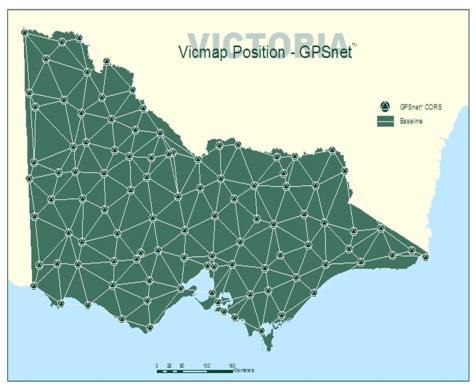


5 Australian Positioning Infrastructure (NPI) Darwin Brisbane /QLD Perth/WA NSW South Australia Tasmania 4/22/ Victoria


6 Multi-GNSS Australia is in the hot spot By 2020, Australia is projected to be in the GNSS hot-spot with access to 35 GNSS satellites and 7+ constellations at any time Source: Australian Space Policy Unit 4/22/2015 6
 and integrated WV (IWV) Reported to improve the")
 Radar composite")
7 Assimilation in NWP Models Dense CORS networks processed in Near Real Time (~45 min latency) Stable, high quality ZTD (zenith total delay) and integrated WV (IWV) Reported to improve the rainfall and humidity prediction Used operationally in Meteo France, KNMI, tested at MetOffice Forecasting without GPS Forecasting with GPS (courtesy Siebren de Haan KNMI) Radar composite 4/22/2015 7
, Monitoring Climate Variability and Change by Means of GNSS Data Brenot et al.")
8 Ground-based GNSS Climate change monitoring Instrumental bias free, selfcalibration, long-term stability, observation characteristics are consistent across geographical regions and at all times, All-weather conditions Nowcasting Current and 0-6 hours ahead weather forecast Stendel (2006), Monitoring Climate Variability and Change by Means of GNSS Data Brenot et al.(2012), Preliminary signs of the initiation of deep convection by GNSS 4/22/2015 8
9 The NDRG project NDRG Natural Disaster Resilience Grant Funded by the Commonwealth Attorney-General s Department under the Australian National Partnership Agreement on Natural Disaster Resilience signed by Prime Minister and state Premier of Victoria. Under the Agreement, Victoria develops an Implementation Plan, for approval by the Commonwealth Minister for Justice. Partnership RMIT University, Bureau of Meteorology, Department of Environment and Primary Industries (DEPI), Univ of Melbourne, CRC-SI, Met Office/UK Valued at ~$590k for ~2 years Aims/objectives Develop a smart GPS-based WV estimation system for disaster management users to reduce the risks/impact of natural weather disaster events Assimilated to the Australian Community Climate and Earth-System Simulator (ACCESS) model. Complementary to the EU COST Action project Advanced GNSS tropospheric products for monitoring severe weather events and climate (GNSS4SWEC) 4/22/2015 9

10 GNSS ZTD processing strategies (1) 1. NETWORK SOLUTION SHORTEST 2. NETWORK SOLUTION LONGEST 3. BASELINE SOLUTION SHORTEST 4. PPP SOLUTION Shortest BLN solution longest BLN solution 4/22/
11 GNSS ZTD processing strategies (2) 6/March 6 days radiosonde data used Scenario Compared with CODE Final TRP solutions based on precise and predicted IGS products (mm) Compared with radiosonde Bias Std Bias Std Bias std Bias mostly due to the radiosonde dry bias SHORT LONG Yuan, Zhang et al (2014), JGR PPP /22/

12 Storm passage vs GNSS CORS Storm passage from radar image over Victorian GPSnet CORS stations Storm direction Selected cross section 4/22/
13 GNSS and storm passage detection ZTD observed by CORS stations over Melbourne storm in 2010 BALL EXCESSIVE WV TIME SHIFT BACC ~ 8 hrs between the passage of the cold front and dissipation observed MOBS 05/March 06/March The storm occurred at 4am (UTC) on 6 March (2pm Melbourne time) 4/22/


14 Correlation between PWV and rainfall 4/22/


15 GNSS tomography technique 4/22/

16 Signature of storms using GNSS tomo Tomography can capture the dynamics of the storm in horizontal and vertical direction 4/22/
17 Multi-observational GPS tomography Case study: January 2011 Melbourne storms Additions to the observation model Additional observations Campaign 1 DD SWD Campaign 2 DD SWD RS Campaign 3 DD SWD Synoptic Campaign 4 DD SWD GPS RO Campaign 5 DD SWD RS Synoptic GPS RO 4/22/
, Zhang et al (IEEE JSTAR, 2015) 4/22/2015")
18 Multi-observational GPS Tomography Preliminary results Overall RMS RMS prior and during storm Manning T (2014), Zhang et al (IEEE JSTAR, 2015) 4/22/
 Real-time/near realtime data stream, upto 1Hz observations")
19 Current RMIT NRT system (1) VICNET NRT Network IGS stations (~8) ARGN stations (34) GPSnet stations (114) Real-time/near realtime data stream, upto 1Hz observations 4/22/
20 Current NRT platform (2) Network DD Fixed solution Operational since 10/03/2015, Estimation in 30 min interval, Window length 6 hours, Stacking strategy from 7 last processing windows PPP (Precise Point Positioning) Operational since 22/03/2015, Estimation in 15 min interval, Window length 6 hours, Final results come from 1 window. Network Float DD solution operational since 27/03/2015, processing window/interval as is in the DD Fixed solution 4/22/
21 Preliminary quality assessment (CODE Final/Rapid ZTD) ZTD bias [mm] DD DD STACKED PPP ZTD STD [mm] CEDU HOB2 MOBS PARK STR2 TID DD DD STACKED PPP CEDU HOB2 MOBS PARK STR2 TID1 4/22/
 ZTD discrepancies [mm] Fixed DD (7 windows) ZTD North gradient discrepancies [mm] 0-5 15.2280 15.2285 15.2290 15.2295 15.2300 15.2305 15.2310 15.2315 15.")
22 Preliminary quality assessment (CODE Rapid ZTD) Fixed DD (7 windows stacked) ZTD discrepancies [mm] Fixed DD (7 windows) ZTD North gradient discrepancies [mm] CEDU HOB2 MOBS STR2 TID1 CEDU HOB2 MOBS STR2 TID1 Fixed DD (7 windows stacked) ZTD East gradient discrepancies [mm] 4/22/
23 Summary Significant development over Australian NPI through NCRIS Signatures of severe weather investigated following our successful operational use of GPS RO since 2012 RT/NRT ground-based ZTD platform based on NPI has been developed and the data assimilation trials are under way GNSS atmosphere sounding represents a milestone improvement in environmental sensing technology Continuous & accurate measurements of atmospheric parameters with good spatial & temporal resolutions are important for NWP & climate analysis It opens new avenues for atmospheric info acquisition Good potential for severe weather events (ground-/space-based) Of particular importance to data void regions (e.g. Australia) Its large area and relatively less dense radiosonde observations Long coastal zones + large ocean areas 4/22/
 Research Centre, School")

24 Thank you Professor Kefei Zhang Director, Satellite Positioning for Atmosphere, Climate and Environment (SPACE) Research Centre, School of Mathematical and GeoSpatial Sciences, RMIT University Tel: , 4/22/
, Float DD ~ 10 min (all possible stages are parallelized), Stack TRO (DD Fix/Float) ~ 12 min (uses one CPU only).")
25 Computation schedule space3 RMIT server computation loading: 4 CPUs available with 4GB of RAM, (8 CPUs and 8GB for tests) DD estimation ~ 12 min (all possible stages are parallelized), PPP ~ 13 min (all possible stages are parallelized), Float DD ~ 10 min (all possible stages are parallelized), Stack TRO (DD Fix/Float) ~ 12 min (uses one CPU only). This represents the time taken by these processors within an hour 22-Apr-15 Group Meeting / Jan Kaplon 25
26 Quality assesment w.r.t. CODE Final/Rapid ZTD ZTD max bias [mm] 60.0 CEDU HOB2 MOBS PARK STR2 TID DD DD STACKED PPP 10.0 ZTD min bias [mm] DD DD STACKED PPP CEDU HOB2 MOBS PARK STR2 TID1 22-Apr-15 Group meeting / Jan Kaplon 26
Emerging GNSS based tropospheric products
 Emerging GNSS based tropospheric products Jaroslaw Bosy, Witold Rohm, Jan Kaplon, Tomasz Hadas, Karina Wilgan, Pawel Hordyniec, Krzysztof Sosnica, Kamil Kazmierski, Jan Sierny The 7th China Satellite Navigation
Use of ground-based GNSS measurements in data assimilation. Reima Eresmaa Finnish Meteorological Institute
 Use of ground-based GNSS measurements in data assimilation Reima Eresmaa Finnish Meteorological Institute 16 June 2006 Outline 1) Introduction GNSS * positioning Tropospheric delay 2) GNSS as a meteorological
Humidity 3D field comparisons between GNSS tomography, IASI satellite observations and ALARO model. Belgian Institute for Space Aeronomy BIRA 3
 Oral Presentation, EGU0-85 Humidity D field comparisons between, H. Brenot, C. Champollion, A. Deckmyn, R. van Malderen, N. Kumps, R. Warnant, E. Goudenhoofdt, L. Delobbe and M. De Mazière contact: Belgian
Exploitation of ground based GPS for Climate and Numerical Weather Prediction applications COST action 716
 Exploitation of ground based GPS for Climate and Numerical Weather Prediction applications COST action 716 COST Objectives and status of COST 716 Overview of work packages / projects Near real-time demonstration
Using Signals Emitted by Global Navigation Satellite Systems
 Using Signals Emitted by Global Navigation Satellite Systems Eric Pottiaux PhD. Thesis submitted for the Degree of Doctor in Sciences Co-Promotors: Carine Bruyninx and Pascale Defraigne Université Catholique
About E-GVAP and the collaboration between geodesy and meteorology
 EIG EUMETNET GNSS Water Vapour Programme E-GVAP About E-GVAP and the collaboration between geodesy and meteorology Henrik Vedel, hev@dmi.dk, DMI and E-GVAP team Siebren de Haan, siebren.de.haan@knmi.nl
WG2 MEETING POTSDAM SEP 1, 2016, 9:00-11:30 AGENDA AND ABSTRACTS
 WG2 MEETING POTSDAM SEP 1, 2016, 9:00-11:30 AGENDA AND ABSTRACTS Eric Pottiaux and Siebren de Haan COST ES1206 http://gnss4swec.knmi.nl Contents Agenda... 2 Tropical cyclone intensification, water vapor
Ground-based GPS networks for remote sensing of the atmospheric water vapour content: a review
 Ground-based GPS networks for remote sensing of the atmospheric water vapour content: a review Gunnar Elgered Earth and Space Sciences, Chalmers University of Technology, Onsala Space Observatory, SE-43992
Synergetic Use of GPS Water Vapor and Meteosat Images for Synoptic Weather Forecasting
 514 JOURNAL OF APPLIED METEOROLOGY Synergetic Use of GPS Water Vapor and Meteosat Images for Synoptic Weather Forecasting SIEBREN DE HAAN, SYLVIA BARLAG, HENK KLEIN BALTINK, AND FRANS DEBIE KNMI, De Bilt,
E-GVAP. (EUMETNET GPS Water Vapour Programme) Workshop. November 6, 2008 DMI, Copenhagen
 Workshop. November 6, 2008 DMI, Copenhagen") E-GVAP (EUMETNET GPS Water Vapour Programme) Workshop November 6, 2008 DMI, Copenhagen Images courtsy Chalmers Programme 9:30-9:45 Introduction, Henrik Vedel 9:45-10:30 Processing of ground based GNSS
E-GVAP (EUMETNET GPS Water Vapour Programme) Workshop November 6, 2008 DMI, Copenhagen Images courtsy Chalmers Programme 9:30-9:45 Introduction, Henrik Vedel 9:45-10:30 Processing of ground based GNSS
Atmospheric Water Vapour Observations
 Royal Observatory of Belgium Solar-Terrestrial Centre of Excellence Atmospheric Water Vapour Observations AT ROB AND RMI FOR WEATHER AND CLIMATE MONITORING Eric Pottiaux Roeland Van Malderen Julie Berckmans
First Summer School. Advanced Global Navigation Satellite Systems tropospheric products for monitoring severe weather events and climate GNSS4SWEC
 First Summer School Advanced Global Navigation Satellite Systems tropospheric products for monitoring severe weather events and climate GNSS4SWEC Golden Sands, Bulgaria 8 11 September 2014 GNSS4SWEC 1st
Near Real Time atmosphere model based on GNSS and meteorological data from ASG-EUPOS reference stations
 10th Czech-Polish Workshop: Szklarska Porba / Poland - November 5-7, 2009 1/20 Near Real Time atmosphere model based on GNSS and meteorological data from ASG-EUPOS reference stations Bosy J. (1), Rohm
InSAR measurements of volcanic deformation at Etna forward modelling of atmospheric errors for interferogram correction
 InSAR measurements of volcanic deformation at Etna forward modelling of atmospheric errors for interferogram correction Rachel Holley, Geoff Wadge, Min Zhu Environmental Systems Science Centre, University
On the use of meteo data. How to raise the value of EPN s
 On the use of meteo data or How to raise the value of EPN s ZTD product? Jan Dousa & Wolfgang Söhne 50th EUREF TWG, Florence, 2009-05-26 Introduction Last TWG (Jan Dousa's presentation): ti Towards more
2 Sofia University, Sofia, Bulgaria. C Hackman 1, Guergana Guerova 2, S Byram 1, J Dousa 3 and U Hugentobler 4
 International GNSS Service (IGS) Troposphere Products and Working Group Activities C Hackman 1, Guergana Guerova 2, S Byram 1, J Dousa 3 and U Hugentobler 4 1 United States Naval Observatory, Washington,
IMPACT OF GROUND-BASED GPS PRECIPITABLE WATER VAPOR AND COSMIC GPS REFRACTIVITY PROFILE ON HURRICANE DEAN FORECAST. (a) (b) (c)
 (b) (c)") 9B.3 IMPACT OF GROUND-BASED GPS PRECIPITABLE WATER VAPOR AND COSMIC GPS REFRACTIVITY PROFILE ON HURRICANE DEAN FORECAST Tetsuya Iwabuchi *, J. J. Braun, and T. Van Hove UCAR, Boulder, Colorado 1. INTRODUCTION
9B.3 IMPACT OF GROUND-BASED GPS PRECIPITABLE WATER VAPOR AND COSMIC GPS REFRACTIVITY PROFILE ON HURRICANE DEAN FORECAST Tetsuya Iwabuchi *, J. J. Braun, and T. Van Hove UCAR, Boulder, Colorado 1. INTRODUCTION
Operational Aspects of GNSS CORS What is a GNSS CORS system used for?
 Please insert a picture (Insert, Picture, from file). Size according to grey field (10 cm x 25.4 cm). Scale picture: highlight, pull corner point Cut picture: highlight, choose the cutting icon from the
Application of microwave radiometer and wind profiler data in the estimation of wind gust associated with intense convective weather
 Application of microwave radiometer and wind profiler data in the estimation of wind gust associated with intense convective weather P W Chan 1 and K H Wong 2 1 Hong Kong Observatory, 134A Nathan Road,
The Nowcasting Demonstration Project for London 2012
 The Nowcasting Demonstration Project for London 2012 Susan Ballard, Zhihong Li, David Simonin, Jean-Francois Caron, Brian Golding, Met Office, UK Introduction The success of convective-scale NWP is largely
E-GVAP Status and outlook
 EIG EUMETNET GNSS Water Vapour Programme E-GVAP E-GVAP Status and outlook Henrik Vedel, hev@dmi.dk, DMI and E-GVAP team Siebren de Haan, siebren.de.haan@knmi.nl KNMI and E-GVAP team Jonathan Jones, jonathan.jones@metoffice.gov.uk,
The role of CORS GNSS data for climate monitoring: case study using NIGNET network
 The role of CORS GNSS data for climate monitoring: case study using NIGNET network Adeyemi ADEBOMEHIN, A. AYOOLA, Kufrey EKO, Nigeria and André SÁ, Portugal Key words: GNSS, CORS, Climate, Water Vapor
The Role of CORS GNSS Data for Climate Monitoring: Case Study using NIGNET Network BY
 The Role of CORS GNSS Data for Climate Monitoring: Case Study using NIGNET Network BY Abayomi AYOOLA, Adeyemi ADEBOMEHIN, Kufre Eko (Nigeria) and SÁ ANDRÉ (Portugal). Introduction The 2012 rainy season
Aurora Bell*, Alan Seed, Ross Bunn, Bureau of Meteorology, Melbourne, Australia
 15B.1 RADAR RAINFALL ESTIMATES AND NOWCASTS: THE CHALLENGING ROAD FROM RESEARCH TO WARNINGS Aurora Bell*, Alan Seed, Ross Bunn, Bureau of Meteorology, Melbourne, Australia 1. Introduction Warnings are
Aviation Hazards: Thunderstorms and Deep Convection
 Aviation Hazards: Thunderstorms and Deep Convection TREND Diagnosis of thunderstorm hazards using imagery Contents Satellite imagery Visible, infrared, water vapour Basic cloud identification Identifying
MSG FOR NOWCASTING - EXPERIENCES OVER SOUTHERN AFRICA
 MSG FOR NOWCASTING - EXPERIENCES OVER SOUTHERN AFRICA Estelle de Coning and Marianne König South African Weather Service, Private Bag X097, Pretoria 0001, South Africa EUMETSAT, Am Kavalleriesand 31, D-64295
Current Limited Area Applications
 Current Limited Area Applications Nils Gustafsson SMHI Norrköping, Sweden nils.gustafsson@smhi.se Outline of talk (contributions from many HIRLAM staff members) Specific problems of Limited Area Model
Development of a UK National Water Vapour Processing System
 Development of a UK National Water Vapour Processing System Jonathan Jones and John Nash Met Office, Exeter, United Kingdom. Tel +44 (0) 1392 885646, Fax +44 (0) 1392 885681, Email jonathan.jones@metoffice.com
Characteristics of GPS ZTD products. Jan Douša EUREF Analysis Centre Workshop
 Characteristics of GPS ZTD products Jan Douša EUREF Analysis Centre Workshop March 15-16, 2006 Outline ZTD and PWV products Stragegy changes GPS constellation effect solution characteristics ZTD differences
USE OF TOTAL COLUMN WATER VAPOR MEASUREMENTS FOR FORECASTS OF THE NORTH AMERICAN MONSOON PRECIPITATION
 USE OF TOTAL COLUMN WATER VAPOR MEASUREMENTS FOR FORECASTS OF THE NORTH AMERICAN MONSOON PRECIPITATION Presented by Yolande Serra University of Arizona Collaborators / Support Ave Arellano (UA Faculty)
CHAPTER 13 WEATHER ANALYSIS AND FORECASTING MULTIPLE CHOICE QUESTIONS
 CHAPTER 13 WEATHER ANALYSIS AND FORECASTING MULTIPLE CHOICE QUESTIONS 1. The atmosphere is a continuous fluid that envelops the globe, so that weather observation, analysis, and forecasting require international
Developments at DWD: Integrated water vapour (IWV) from ground-based GPS
 from ground-based GPS") 1 Working Group on Data Assimilation 2 Developments at DWD: Integrated water vapour (IWV) from ground-based Christoph Schraff, Maria Tomassini, and Klaus Stephan Deutscher Wetterdienst, Frankfurter Strasse
1 Working Group on Data Assimilation 2 Developments at DWD: Integrated water vapour (IWV) from ground-based Christoph Schraff, Maria Tomassini, and Klaus Stephan Deutscher Wetterdienst, Frankfurter Strasse
Royal Netherlands Meteorological Institute Ministry of Infrastructure and the Environment
 Royal Netherlands Meteorological Institute Ministry of Infrastructure and the Environment 3D Exploration of Weather Data in Combination with IASI L2 Products for Better Understanding of Potential Applications
Water vapour above Switzerland over the last 12 years
 Water vapour above Switzerland over the last 12 years June Morland*, Martine Collaud**, Klemens Hocke*, Pierre Jeannet**, Christian Mätzler* *Institute of Applied Physics, University of Bern **MeteoSwiss
QPE and QPF in the Bureau of Meteorology
 QPE and QPF in the Bureau of Meteorology Current and future real-time rainfall products Carlos Velasco (BoM) Alan Seed (BoM) and Luigi Renzullo (CSIRO) OzEWEX 2016, 14-15 December 2016, Canberra Why do
Numerical prediction of severe convection: comparison with operational forecasts
 Meteorol. Appl. 10, 11 19 (2003) DOI:10.1017/S1350482703005024 Numerical prediction of severe convection: comparison with operational forecasts Milton S. Speer 1, Lance M. Leslie 2 & L. Qi 2 1 Bureau of
Presented by Ertan TURGU*
 Ministry of Forestry and Water Affairs Turkish State Meteorological Service A Case Study: Analysis of Flash Flood Using FFGS Products on 17 January 2016 in Çeşme, Dikili, Izmir and Manisa. Presented by
An investigation into the COSMIC radio occultation outage during the 2015 St. Patrick s Day geomagnetic storm
 An investigation into the COSMIC radio occultation outage during the 2015 St. Patrick s Day geomagnetic storm Brett A. Carter 1, Kefei Zhang 1, Bill Schreiner 2, Maggie Sleziak 2, Robert Norman 1, Adam
COST-716, EUMETNET and possible role of EUREF
 EUREF TWG Meeting, Budapest, Hungary, March 22-23, 2004 COST-716, EUMETNET and possible role of EUREF Hans VAN DER MAREL, Elmar BROCKMANN Delft University of Technology, Aerospace Engineering (DEOS/MGP)
ABSTRACT 3 RADIAL VELOCITY ASSIMILATION IN BJRUC 3.1 ASSIMILATION STRATEGY OF RADIAL
 REAL-TIME RADAR RADIAL VELOCITY ASSIMILATION EXPERIMENTS IN A PRE-OPERATIONAL FRAMEWORK IN NORTH CHINA Min Chen 1 Ming-xuan Chen 1 Shui-yong Fan 1 Hong-li Wang 2 Jenny Sun 2 1 Institute of Urban Meteorology,
Use and impact of satellite data in the NZLAM mesoscale model for the New Zealand region
 Use and impact of satellite data in the NZLAM mesoscale model for the New Zealand region V. Sherlock, P. Andrews, H. Oliver, A. Korpela and M. Uddstrom National Institute of Water and Atmospheric Research,
Impact of GPS and TMI Precipitable Water Data on Mesoscale Numerical Weather Prediction Model Forecasts
 Journal of the Meteorological Society of Japan, Vol. 82, No. 1B, pp. 453--457, 2004 453 Impact of GPS and TMI Precipitable Water Data on Mesoscale Numerical Weather Prediction Model Forecasts Ko KOIZUMI
Verification of the meteorological observations on the EPN stations
 Institute of Geodesy and Geoinformatics Wroclaw University of Environmental and Life Sciences Verification of the meteorological observations on the EPN stations Jarosław aw Bosy Witold Rohm bosy@kgf.ar.wroc.pl;
On the use of radar rainfall estimates and nowcasts in an operational heavy rainfall warning service
 On the use of radar rainfall estimates and nowcasts in an operational heavy rainfall warning service Alan Seed, Ross Bunn, Aurora Bell Bureau of Meteorology Australia The Centre for Australian Weather
Mode-S EHS data usage in the meteorological domain:
 Mode-S EHS data usage in the meteorological domain: derivation of Wind and Temperature observations; and assimilation of these observations in a numerical weather prediction model. Jan Sondij, MBA Senior
WG1 Overview. PP KENDA for km-scale EPS: LETKF. current DA method: nudging. radar reflectivity (precip): latent heat nudging 1DVar (comparison)
: latent heat nudging 1DVar (comparison)") WG1 Overview Deutscher Wetterdienst, D-63067 Offenbach, Germany current DA method: nudging PP KENDA for km-scale EPS: LETKF radar reflectivity (precip): latent heat nudging 1DVar (comparison) radar radial
WG1 Overview Deutscher Wetterdienst, D-63067 Offenbach, Germany current DA method: nudging PP KENDA for km-scale EPS: LETKF radar reflectivity (precip): latent heat nudging 1DVar (comparison) radar radial
AOMSUC-6 Training Event
 Effective use of high temporal and spatial resolution Himawari-8 data AOMSUC-6 Training Event Bodo Zeschke Australian Bureau of Meteorology Training Centre Australian VLab Centre of Excellence Content
For the operational forecaster one important precondition for the diagnosis and prediction of
 Initiation of Deep Moist Convection at WV-Boundaries Vienna, Austria For the operational forecaster one important precondition for the diagnosis and prediction of convective activity is the availability
Joint Meeting of RA II WIGOS Project and RA V TT-SU on 11 October 2018 BMKG Headquarter Jakarta, Indonesia. Mrs. Sinthaly CHANTHANA
 Joint Meeting of RA II WIGOS Project and RA V TT-SU on 11 October 2018 BMKG Headquarter Jakarta, Indonesia Mrs. Sinthaly CHANTHANA Lao PDR Background Department of Meteorology and Hydrology ( DMH ) in
p = ρrt p = ρr d = T( q v ) dp dz = ρg
 dp dz = ρg") Chapter 1: Properties of the Atmosphere What are the major chemical components of the atmosphere? Atmospheric Layers and their major characteristics: Troposphere, Stratosphere Mesosphere, Thermosphere
Chapter 1: Properties of the Atmosphere What are the major chemical components of the atmosphere? Atmospheric Layers and their major characteristics: Troposphere, Stratosphere Mesosphere, Thermosphere
GNSS METEOROLOGY AND WATER VAPOUR ESTIMATION IN TURKEY
 GNSS METEOROLOGY AND WATER VAPOUR ESTIMATION IN TURKEY DR. CETIN MEKIK ASSOC. PROF., THE DEPT. OF GEOMATICS ENGINEERING BULENT ECEVIT UNIVERSITY, ZONGULDAK/TURKEY GNSS4SWEC MC&WG Meeting, Varna, Bulgaria,
12/07/2017. Flash Flood Warning Service, an advanced approach towards flood resilient cities Floodplain Management Association Conference, Newcastle
 12/07/2017 Worldwide problem: Flash Floods Flash Floods are a Global Problem Flash Flood Warning Service, an advanced approach towards flood resilient cities Floodplain Management Association Conference,
HIGH SPATIAL AND TEMPORAL RESOLUTION ATMOSPHERIC MOTION VECTORS GENERATION, ERROR CHARACTERIZATION AND ASSIMILATION
 HIGH SPATIAL AND TEMPORAL RESOLUTION ATMOSPHERIC MOTION VECTORS GENERATION, ERROR CHARACTERIZATION AND ASSIMILATION John Le Marshall Director, JCSDA 2004-2007 CAWCR 2007-2010 John Le Marshall 1,2, Rolf
Validation of Climate Models Using Ground-Based GNSS Observations. Dep. of Earth and Space Sciences, Onsala Space Observatory, SE Onsala
 Validation of Climate Models Using Ground-Based GNSS Observations Gunnar Elgered 1, Jan Johansson 1,2, Erik Kjellström 3, Ragne Emardson 2, Per Jarlemark 2, Tobias Nilsson 1,4, Tong Ning 1, Ulrika Willén
Introduction to Meteorology and Weather Forecasting
 Introduction to Meteorology and Weather Forecasting ENVI1400 : Meteorology and Forecasting : lecture 1 2 040909 ENVI1400 : Meteorology and Forecasting : lecture 1 3 040914 ENVI1400 : Meteorology and Forecasting
OVERVIEW OF EUMETSAT RADIO OCCULTATION ACTIVITIES
 1 Eighth FORMOSAT-3/COSMIC Data Users' Workshop, Sep/Oct 2014, Boulder OVERVIEW OF EUMETSAT RADIO OCCULTATION ACTIVITIES Axel von Engeln, Christian Marquardt, Yago Andres Overview EUMETSAT Mission Overview
Observing System Impact Studies in ACCESS
 Observing System Impact Studies in ACCESS www.cawcr.gov.au Chris Tingwell, Peter Steinle, John le Marshall, Elaine Miles, Yi Xiao, Rolf Seecamp, Jin Lee, Susan Rennie, Xingbao Wang, Justin Peter, Alan
COST Action ES1206 Advanced Global Navigation Satellite Systems tropospheric products for monitoring severe weather events and climate (GNSS4SWEC)
") COST Action ES1206 Advanced Global Navigation Satellite Systems tropospheric products for monitoring severe weather events and climate (GNSS4SWEC) R. Pacione, J. Jones, G. Guerova, J. Dousa, G. Dick, S.
COST Action ES1206 Advanced Global Navigation Satellite Systems tropospheric products for monitoring severe weather events and climate (GNSS4SWEC) R. Pacione, J. Jones, G. Guerova, J. Dousa, G. Dick, S.
MEMORANDUM OF UNDERSTANDING
 MEMORANDUM OF UNDERSTANDING between A: EUREF, the Reference Frame Sub-Commission for Europe of the International Association of Geodesy (IAG) and B: EUMETNET, the Network of European Meteorological Services.
ATS 351, Spring 2010 Lab #11 Severe Weather 54 points
 ATS 351, Spring 2010 Lab #11 Severe Weather 54 points Question 1 (10 points): Thunderstorm development a) Sketch and describe the stages of development of a single cell thunderstorm. About how long does
Recent experience at Météo-France on the assimilation of observations at high temporal frequency Cliquez pour modifier le style du titre
 Recent experience at Météo-France on the assimilation of observations at high temporal frequency Cliquez pour modifier le style du titre J.-F. Mahfouf, P. Brousseau, P. Chambon and G. Desroziers Météo-France/CNRS
Sofia University GNSS Analysis Center (SUGAC)
") Tzvetan SIMEONOV, Bulgaria, Dmitry SIDOROV, Luxembourg, Norman TEFERLE, Luxembourg, Guergana GUEROVA, Bulgaria, Evgenia EGOVA, Bulgaria, Keranka VASSILEVA, Bulgaria, Ivo MILEV, Germany, Key words: GNSS
Tzvetan SIMEONOV, Bulgaria, Dmitry SIDOROV, Luxembourg, Norman TEFERLE, Luxembourg, Guergana GUEROVA, Bulgaria, Evgenia EGOVA, Bulgaria, Keranka VASSILEVA, Bulgaria, Ivo MILEV, Germany, Key words: GNSS
Integrating Hydrologic and Storm Surge Models for Improved Flood Warning
 Integ Hydrologic and Storm Surge Models for Improved Flood Warning Leahy, C.P, Entel, M, Sooriyakumaran, S, and Warren, G Flood Warning Program Office, Bureau of Meteorology, Docklands, Victoria National
PRELIMINARY STUDIES OF THE GNSS APPLICATION TO PRECIPITATION NOWCASTING Luiz Fernando Sapucci. Luiz Augusto Toledo Machado. Izabelly Carvalho.
 PRELIMINARY STUDIES OF THE GNSS APPLICATION TO PRECIPITATION NOWCASTING Luiz Fernando Sapucci. Luiz Augusto Toledo Machado. Izabelly Carvalho. Lucas Amarantes Avanço. Integrated water vapor from Global
Ground-based temperature and humidity profiling using microwave radiometer retrievals at Sydney Airport.
 Ground-based temperature and humidity profiling using microwave radiometer retrievals at Sydney Airport. Peter Ryan Bureau of Meteorology, Melbourne, Australia Peter.J.Ryan@bom.gov.au ABSTRACT The aim
Sensitivity of precipitation forecasts to cumulus parameterizations in Catalonia (NE Spain)
") Sensitivity of precipitation forecasts to cumulus parameterizations in Catalonia (NE Spain) Jordi Mercader (1), Bernat Codina (1), Abdelmalik Sairouni (2), Jordi Cunillera (2) (1) Dept. of Astronomy and
Sensitivity of precipitation forecasts to cumulus parameterizations in Catalonia (NE Spain) Jordi Mercader (1), Bernat Codina (1), Abdelmalik Sairouni (2), Jordi Cunillera (2) (1) Dept. of Astronomy and
THE IMPACT OF GROUND-BASED GPS SLANT-PATH WET DELAY MEASUREMENTS ON SHORT-RANGE PREDICTION OF A PREFRONTAL SQUALL LINE
 JP1.17 THE IMPACT OF GROUND-BASED GPS SLANT-PATH WET DELAY MEASUREMENTS ON SHORT-RANGE PREDICTION OF A PREFRONTAL SQUALL LINE So-Young Ha *1,, Ying-Hwa Kuo 1, Gyu-Ho Lim 1 National Center for Atmospheric
DETECTION AND FORECASTING - THE CZECH EXPERIENCE
 1 STORM RAINFALL DETECTION AND FORECASTING - THE CZECH EXPERIENCE J. Danhelka * Czech Hydrometeorological Institute, Prague, Czech Republic Abstract Contribution presents the state of the art of operational
Recent Data Assimilation Activities at Environment Canada
 Recent Data Assimilation Activities at Environment Canada Major upgrade to global and regional deterministic prediction systems (now in parallel run) Sea ice data assimilation Mark Buehner Data Assimilation
REQUIREMENTS FOR WEATHER RADAR DATA. Review of the current and likely future hydrological requirements for Weather Radar data
 WORLD METEOROLOGICAL ORGANIZATION COMMISSION FOR BASIC SYSTEMS OPEN PROGRAMME AREA GROUP ON INTEGRATED OBSERVING SYSTEMS WORKSHOP ON RADAR DATA EXCHANGE EXETER, UK, 24-26 APRIL 2013 CBS/OPAG-IOS/WxR_EXCHANGE/2.3
The Australian Operational Daily Rain Gauge Analysis
 The Australian Operational Daily Rain Gauge Analysis Beth Ebert and Gary Weymouth Bureau of Meteorology Research Centre, Melbourne, Australia e.ebert@bom.gov.au Daily rainfall data and analysis procedure
Workshop on Numerical Weather Models for Space Geodesy Positioning
 Workshop on Numerical Weather Models for Space Geodesy Positioning Marcelo C. Santos University of New Brunswick, Department of Geodesy and Geomatics Engineering, Fredericton, NB Room C25 (ADI Room), Head
NUMERICAL EXPERIMENTS USING CLOUD MOTION WINDS AT ECMWF GRAEME KELLY. ECMWF, Shinfield Park, Reading ABSTRACT
 NUMERICAL EXPERIMENTS USING CLOUD MOTION WINDS AT ECMWF GRAEME KELLY ECMWF, Shinfield Park, Reading ABSTRACT Recent monitoring of cloud motion winds (SATOBs) at ECMWF has shown an improvement in quality.
Improving real time observation and nowcasting RDT. E de Coning, M Gijben, B Maseko and L van Hemert Nowcasting and Very Short Range Forecasting
 Improving real time observation and nowcasting RDT E de Coning, M Gijben, B Maseko and L van Hemert Nowcasting and Very Short Range Forecasting Introduction Satellite Application Facilities (SAFs) are
Climate Monitoring with GPS RO Achievements and Challenges
 Climate Monitoring with GPS RO Achievements and Challenges A.K. Steiner Wegener Center for Climate and Global Change (WEGC) and IGAM/Inst. of Physics, University of Graz, Austria andi.steiner@uni-graz.at
Data impact studies in the global NWP model at Meteo-France
 Data impact studies in the global NWP model at Meteo-France Patrick Moll, Fatima Karbou, Claudia Faccani, Nathalie Saint- Ramond, Florence Rabier Centre National de Recherches Météorologiques CNRS/GAME,
The PaTrop Experiment
 Improved estimation of the tropospheric delay component in GNSS and InSAR measurements in the Western Corinth Gulf (Greece), by the use of a highresolution meteorological model: The PaTrop Experiment N.
Smart use of Geographic Information System (GIS) platform for delivering weather information and nowcasting services
 platform for delivering weather information and nowcasting services") Smart use of Geographic Information System (GIS) platform for delivering weather information and nowcasting services C. K. Pan Hong Kong Observatory Hong Kong, China It is a world of beauty Source: Image
Smart use of Geographic Information System (GIS) platform for delivering weather information and nowcasting services C. K. Pan Hong Kong Observatory Hong Kong, China It is a world of beauty Source: Image
Unit 5 Lesson 3 How is Weather Predicted? Copyright Houghton Mifflin Harcourt Publishing Company
 Tracking the Weather Warm up 1 Why is it important to watch the weather forecast before traveling to another country? Tracking the Weather A meteorologist is a scientist who studies weather. Meteorologists
WEATHER AND CLIMATE EXTREMES MONITORING BASED ON SATELLITE OBSERVATION : INDONESIA PERSPECTIVE RIRIS ADRIYANTO
 WEATHER AND CLIMATE EXTREMES MONITORING BASED ON SATELLITE OBSERVATION : INDONESIA PERSPECTIVE RIRIS ADRIYANTO INDONESIA AGENCY FOR METEOROLOGY, CLIMATOLOGY AND GEOPHYSICS (BM KG) 1. INTRODUCTION - BMKG
Judit Kerényi. OMSZ - Hungarian Meteorological Service, Budapest, Hungary. H-1525 Budapest, P.O.Box 38, Hungary.
 SATELLITE-DERIVED PRECIPITATION ESTIMATIONS DEVELOPED BY THE HYDROLOGY SAF PROJECT CASE STUDIES FOR THE INVESTIGATION OF THEIR ACCURACY AND FEATURES IN HUNGARY Judit Kerényi OMSZ - Hungarian Meteorological
EUREF E-GVAP Memorandum of Understanding. Status of E-GVAP
 EUREF E-GVAP Memorandum of Understanding and Status of E-GVAP What is E-GVAP? EUMETNET GPS Water Vapour Programme EUMETNET = organisation of European national meteorological offices (West European + number
ATMOSPHERIC MODELLING. GEOG/ENST 3331 Lecture 9 Ahrens: Chapter 13; A&B: Chapters 12 and 13
 ATMOSPHERIC MODELLING GEOG/ENST 3331 Lecture 9 Ahrens: Chapter 13; A&B: Chapters 12 and 13 Agenda for February 3 Assignment 3: Due on Friday Lecture Outline Numerical modelling Long-range forecasts Oscillations
AFAC 2006 page 536. Climate-Change Impacts on fire-weather in SE Australia Kevin Hennessy, Principal Research Scientist, CSIRO
 AFAC 2006 page 536 Climate-Change Impacts on fire-weather in SE Australia Kevin Hennessy, Principal Research Scientist, CSIRO AFAC 2006 page 537 Climate change impacts on fire-weather risk in south-east
The importance of satellite data and products for RA1 in the WWRP strategy. Estelle de Coning World Weather Research Division
 The importance of satellite data and products for RA1 in the WWRP strategy Estelle de Coning World Weather Research Division Kofi Annan former UN Secretary-General (21 July 2016) "The poor need alerts
Application of Atmosphere Precipitation Resources Distribution Remote Sensed by Ground-based GPS in the West of Taiwan Strait.
 4th International Conference on Mechatronics, Materials, Chemistry and Computer Engineering (ICMMCCE 2015) Application of Atmosphere Precipitation Resources Distribution Remote Sensed by Ground-based GPS
onboard of Metop-A COSMIC Workshop 2009 Boulder, USA
 GRAS Radio Occultation Measurements onboard of Metop-A A. von Engeln 1, Y. Andres 1, C. Cardinali 2, S. Healy 2,3, K. Lauritsen 3, C. Marquardt 1, F. Sancho 1, S. Syndergaard 3 1 2 3 EUMETSAT, ECMWF, GRAS
Dynamic statistical optimization of GNSS radio occultation bending angles: an advanced algorithm and performance analysis results
 Dynamic statistical optimization of GNSS radio occultation bending angles: an advanced algorithm and performance analysis results Ying Li 1,2, Gottfried Kirchengast 3,2, Barbara Scherllin-Pirscher 3, Robert
esa ACE+ An Atmosphere and Climate Explorer based on GPS, GALILEO, and LEO-LEO Occultation Per Høeg (AIR/DMI) Gottfried Kirchengast (IGAM/UG)
 Gottfried Kirchengast (IGAM/UG)") ACE+ An Atmosphere and Climate Explorer based on GPS, GALILEO, and LEO-LEO Occultation Per Høeg (AIR/DMI) Gottfried Kirchengast (IGAM/UG) OPAC-1, September, 2002 1 Objectives Climate Monitoring global
ACE+ An Atmosphere and Climate Explorer based on GPS, GALILEO, and LEO-LEO Occultation Per Høeg (AIR/DMI) Gottfried Kirchengast (IGAM/UG) OPAC-1, September, 2002 1 Objectives Climate Monitoring global
National Public Weather and Warning Services in the Swaziland Meteorological Service Dennis S.Mkhonta /
 National Public Weather and Warning Services in the Swaziland Meteorological Service Dennis S.Mkhonta dennis.mkhonta@gmail.com / dennis@swazimet.gov.sz Introduction Swaziland s geographical position exposes
HY-2A Satellite User s Guide
 National Satellite Ocean Application Service 2013-5-16 Document Change Record Revision Date Changed Pages/Paragraphs Edit Description i Contents 1 Introduction to HY-2 Satellite... 1 2 HY-2 satellite data
Application and verification of ECMWF products 2011
 Application and verification of ECMWF products 2011 National Meteorological Administration 1. Summary of major highlights Medium range weather forecasts are primarily based on the results of ECMWF and
Assimilation of ground-based GPS data into a limited area model. M. Tomassini*
 Assimilation of ground-based GPS data into a limited area model M. Tomassini* GeoForschungsZentrum, Potsdam, Germany * On assignment to Deutscher Wetterdienst, Offenbach, Germany Abstract Two years of
Validation of operational NWP forecasts for global, diffuse and direct solar exposure over Australia
 Validation of operational NWP forecasts for global, diffuse and direct solar exposure over Australia www.bom.gov.au Lawrie Rikus, Paul Gregory, Zhian Sun, Tomas Glowacki Bureau of Meteorology Research
AROME Nowcasting - tool based on a convective scale operational system
 AROME Nowcasting - tool based on a convective scale operational system RC - LACE stay report Supervisors (ZAMG): Yong Wang Florian Meier Christoph Wittmann Author: Mirela Pietrisi (NMA) 1. Introduction
Grid point spacing (km) T2047 H K T7999 NH M
 T2047 H K T7999 NH M") (Very) High Res NWP ECMWF High-resolution modelling developments (inputs: Nils Wedi, Mats Hamrud, George Mozdzynski, Jean Bidlot, Geir Austad, Sinisa Curic ) Current and planned resolutions: IFS model
(Very) High Res NWP ECMWF High-resolution modelling developments (inputs: Nils Wedi, Mats Hamrud, George Mozdzynski, Jean Bidlot, Geir Austad, Sinisa Curic ) Current and planned resolutions: IFS model
Diabatic processes and the structure of the warm conveyor belt
 2 nd European Windstorm Workshop Leeds, 3-4 September 2012 Diabatic processes and the structure of the warm conveyor belt Oscar Martínez-Alvarado J. Chagnon, S. Gray, R. Plant, J. Methven Department of
Bias correction of satellite data at Météo-France
 Bias correction of satellite data at Météo-France É. Gérard, F. Rabier, D. Lacroix, P. Moll, T. Montmerle, P. Poli CNRM/GMAP 42 Avenue Coriolis, 31057 Toulouse, France 1. Introduction Bias correction at
The Impacts of GPS Radio Occultation Data on the Analysis and Prediction of Tropical Cyclones. Bill Kuo, Xingqin Fang, and Hui Liu UCAR COSMIC
 The Impacts of GPS Radio Occultation Data on the Analysis and Prediction of Tropical Cyclones Bill Kuo, Xingqin Fang, and Hui Liu UCAR COSMIC GPS Radio Occultation α GPS RO observations advantages for
The Status of GNSS Data Processing Systems to Estimate Integrated Water Vapour for Use in Numerical Weather Prediction Models
 Manuscript Click here to download Manuscript: IAG_Furqan.tex Click here to view linked References myjournal manuscript No. (will be inserted by the editor) The Status of GNSS Data Processing Systems to