Avalanche Fatality on Mt. Hermann near Mt Baker, WA
|
|
|
- Amie King
- 6 years ago
- Views:
Transcription
1 Avalanche Fatality on Mt. Hermann near Mt Baker, WA ~0830 AM, Tuesday, April 18 th, 2006 Location of incident Stoneman s chute off Mt. Hermann near Mt Baker, WA Number in party 3; 1 skier caught and killed Type of activity back country ski Elevation ~6000 ft Aspect East-Northeast Slope angle degrees Preliminary Avalanche classification SS-AS-R5-D2.5 Other avalanche information: ft deep x 200 ft wide soft slab; slide traveled approximately 1200 ft vertical through and over several benches, interspersed small evergreens and rock outcrops before depositing victim on a lower bench (slide continued some distance below lower bench) News media Report Wednesday, April 19, 2006 PUBLIC SAFETY California man dies near Mt. Baker KIRA MILLAGE THE BELLINGHAM HERALD A 25-year-old man died Tuesday morning after getting caught in a snow slide while skiing west of the Mt. Baker Ski Area, according to the Whatcom County Sheriff's Office. Tobias Lee of Truckee, Calif., was skiing with his brother and a friend on Mount Herman when snow broke loose and carried him over two rock faces and through trees, according to the Sheriff's Office. Lee was unconscious after the slide and didn't respond to CPR attempts, according to the Sheriff's Office. After members of Bellingham Mountain Rescue were unable to reach Lee due to avalanche danger, a private helicopter was called to remove the body. The two survivors' identities were unknown Tuesday evening, but they are reportedly from the Glacier area, the Sheriff's Office said.
2 Incident report (Avalanche accident narrative courtesy Tom Walgren, friend of the victim and member of the trio (composed of Elias, Toby and Tom) On April 18, 2006, Eli, Toby and myself (Tom) left Heather Meadows parking lot at 0530 AM with the intent of skiing the prominent chute off of Mt. Hermann known as Stoneman. At first the fog was thick, and we put distance between ourselves as we ascended toward Mazama Bowl. The cloud ceiling steadily lifted as we skinned on shallow, crunchy, sometimes icy snow: though a pole could be punched through to 18 inches in places, it did not sound hollow. Upon reaching our intended run we all prepared for the descent. Eli skied down the top of the ridge to access the cornice, Toby stopped about 50 ft above and back by the stunted trees on the ridge. I skied to Toby, stopped and asked Eli if he wanted the rope. He said yes, so I proceeeded to a tree 15 ft behind him and tied the rope off. Eli tied himself into the rope, stepped up to the cornice, and jumped a few times. No movement, so he gives himself more slack and slides over the cornice and jumps again. No movement. Eli unties and I move out holding the rope in both hands to see Eli's descent. After a brief discussion on how he feels about the pack, Eli make about 8 turns and stops on the other side of the choke zone, in a safe spot, under a cliff and above a tree. I slide back and packed up the rope while Toby slid forward to get a visual on his line. When I returned to the edge Eli was recommending a steeper line to the right but Toby had his line sighted and wanted to go so we all confirmed ready. Toby pushed back about 2 feet and then forward with a little boost off of the small cornice. Due to the steep angle at the top this dropped him feet into the steep pitch. With a huge pop the entire slope began moving with Toby in the start zone, then instantly shot down the choke zone of the chute at top speed. I immediately skied to the choke zone to try for last seen spot, but all there was, was a plume of dusty snow in the valley. I turned my transceiver to receive and speed slipped the chute. Eli pulled his shovel and followed. At the first deposition zone, I had no signal and yelled back to Eli to keep chicking behind me in case I missed Toby. On the second deposition zone I foiund a ski, and on the third deposition zone (1200 ft vertical from the start) I got a signal. Either due to sun glare or operator error we briefly dug 2.4 metered from Toby (believing it to be 1.4 meters). Upon realizing this can't be right, I turned my Tracker off then on, reset to receive and immediately moved in Toby'd direction, got the "hyper beep" and uncovered his right hand. Only a couple of inches under Eli found his head, face up, barely covered by snow. We took his melmet off, and Eli started CPR while I dug the rest of Toby out of shallow snows. Then I started compressions while Eli did the breaths and checked vital. Toby didn't make it. Whenever we return with fewer than we left with, the surviving member reel through endless scenarios of how it could have gone different, and these need to be explored to learn from this. Some of my friends asked me what we could learn from this loss. Here is my input. All other scenarios aside, if you end up atop this type of run and it requires a roped ski cut, everyone in the party should enter on rope, and no matter where you go always discuss worst case even when the hazards are obvious. There can never be too much discussion of potential danger especially in a leaderless group. We did not discuss which way to turn when you hear a
3 pop, nor did we discuss the death potential of that slide path. I knew left was better than right, and that surviving a slide there was unlikely, and that an impact could pop a strong weak layer. In a group of skiers at this level, I did not speak up when I should have started discussion.

4 Figure 1. Photo courtesy Lief Hazelet, taken Looking up at Stoneman s chute below Mt Hermann, northern Washington Cascades just west of the Mt Baker ski area. Accident fracture line visible in upper part of chute. Victim entered path in upper left of photo and was carried down the path, over the bench and just below the bottom of the picture.
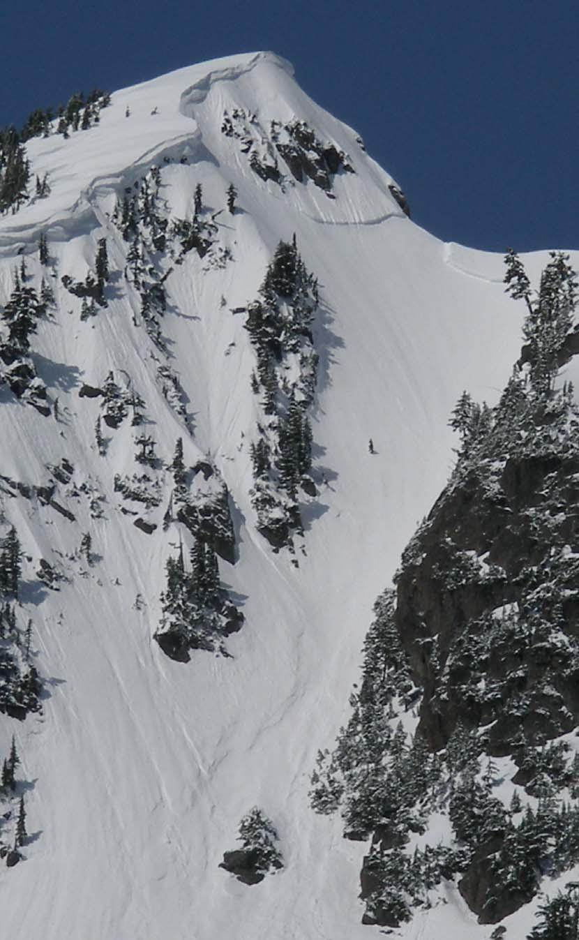
5

6 Figure 2. Another closer view of Stoneman's that shows the objective dangers of the hourglass like chute as well as more of the slab as it wraps from the upper right of the path, extends to the ridge and then crosses under the rocks and cornice where reports indicate that it was probably triggered by the victim. Photo courtesy Toby Tortorelli. Figure 3. Photo courtesy Michael Jackson, taken in mid-late February, Picture looking across upper Stoneman's toward normal entry area into chute.

7 Figure 4. Photo courtesy Michael Jackson. View down Stoneman's from near the top, taken mid-late February, As evident in Figures 1-3, the upper part of Stoneman s is rather steep, in excess of degrees, with a starting elevation of approximately 6,000 ft and vertical fall of ~1,200 ft. Objective dangers are considerable to say the least.
 leading from the upper part of the ski area toward Mt Shuksan.")
8 Figure 5. Photo courtesy Lief Hazelet. Some of the slab avalanche activity that occurred along Shuksan Arm after the accident, releasing on April 21 or 22, Shuksan Arm is a northwest to southeast oriented ridge (within the Mt Baker Wilderness) leading from the upper part of the ski area toward Mt Shuksan. Ancillary Weather, Snowpack and Avalanche Information In reconstructing the weather and its influence at the time of the incident, it appears mostly likely that the group arrived at the top of the east-northeast facing Stoneman s chute under mostly sunny and very slowly warming skies (temperatures remained at or below freezing at the nearby NWAC weather station through 10 AM see the hourly weather data table below). At that time of the morning, the sun may have impacted some of the slope briefly, although it is not known if the sun was on the slope at the time of the event. Hence it is not known if the temperature trend contributed to the instability as it was still relatively early in the morning and the freezing levels that morning were still low the NWS radiosonde station at Forks, Washington reported a 3100 ft freezing level on the 4 AM sounding that rose to 4500 ft by the 4 PM sounding). From the incident narrative, the party had preformed some ski cuts near the top of the slope and had tried to kick off a portion of the small cornice near the top of Stoneman s to test stability on the slope below. As mentioned in the report, these tests were all negative. However, many human triggered slabs had been released along nearby Shuksan Arm Ridge (which lies immediately east of the ski area) during the three to four days prior to the incident (Saturday through Monday) all resulting from the 3 feet plus of snow received late the previous week. It is likely that the group was at least aware of these slide occurrences. The Mt Baker ski area
9 reported 41 inches of new snow from Thursday through Sunday morning, the 13 th -15 th of April while the automated weather station recorded 44 inches from the 13 th -16 th. See the 6-day temperature & snow table below for a chronology of the weather leading up to the event as recorded by the automated weather station at the base of the nearby ski area. Several large slabs were also reported on the 21 st or 22 nd following the incident. Some of these subsequent avalanche releases on nearby Shuksan Arm are shown in Figure 4 above. NWAC hourly telemetry information from 0500, 4/18/ Northwest Weather and Avalanche Center Mt Baker Ski Area, Washington MM/DD Hour Temp RH Hour Total 24 Hr Total PST F % Prec. Prec. Snow Snow 4220' 4220' 4220' 4220' 4220' 4220' day Weather Summary from the NWAC Mt Baker Weather Station (located at nearby Heather Meadows) Tmax = Maximum temperatures (deg F) for 24 hours preceding 4 AM observation on indicated day Tmin = Minimum temperatures (deg F) for 24 hours preceding 4 AM observation on indicated day HN24 = New snowfall (inches of snow) for 24 hours preceding 4 AM observation on indicated day HN24W = Water equivalent of snowfall (inches of WE) for 24 hours preceding 4 AM observation on indicated day HS = Height of snowpack (total depth in inches)
10 Date Day Fri Sat Sun Mon Tues Wed Tmax Tmin HN HN24W HS NWAC Back Country Avalanche Forecasts During the week prior to the incident, the Avalanche Center had issued avalanche warnings for two days (the 13 th and 14 th ), specifically highlighting the northern Washington Cascades). Although the large amounts of new snow from the unseasonably cool and strong spring storm had begun to settle, as indicated in the avalanche forecasts below (issued on the morning of the 17 th and 18 th ), a considerable danger was still expected from the recent storm as substantial clouds and continuing low freezing levels and cool temperatures from the 15 th -17 th had limited recent snowpack stabilization. Avalanche forecast issued on April 17 th BACKCOUNTRY AVALANCHE FORECAST FOR THE OLYMPICS, WASHINGTON CASCADES AND MT HOOD AREA NORTHWEST WEATHER AND AVALANCHE CENTER SEATTLE WASHINGTON 0845 AM PDT MON APR NWAC Program administered by: USDA-Forest Service with cooperative funding and support from: Washington State Department of Transportation National Weather Service National Park Service Washington State Parks and Recreation Commission Pacific Northwest Ski Area Association Friends of the Avalanche Center and other private organizations. This forecast applies to back country avalanche terrain below 7000 feet and does not apply to highways or operating ski areas. WAZ ORZ &&
11 ZONE AVALANCHE FORECASTS WASHINGTON CASCADES NEAR AND WEST OF THE CREST NORTH OF STEVENS PASS- CONSIDERABLE avalanche danger above 4 to 5000 feet and MODERATE below increasing later Monday morning and afternoon and becoming CONSIDERABLE below 7000 feet except locally HIGH on sun exposed terrain. Danger decreasing Monday night but increasing again later Tuesday morning and afternoon and becoming CONSIDERABLE on sun exposed terrain and on north through east exposures above 5000 feet and MODERATE elsewhere. Gradually decreasing danger Tuesday night, becoming CONSIDERABLE above 5 to 6000 feet and MODERATE below. WASHINGTON CASCADES FROM STEVENS PASS SOUTHWARD- EAST SLOPES WASHINGTON CASCADES- MT HOOD AREA- CONSIDERABLE avalanche danger above 5 to 6000 feet and MODERATE below increasing later Monday morning and afternoon and becoming CONSIDERABLE above 4 to 5000 feet and MODERATE below, with greatest danger on sun exposed terrain. Danger decreasing Monday night but increasing again later Tuesday morning and afternoon and becoming CONSIDERABLE on sun exposed terrain and on north through east exposures above 5000 feet and MODERATE elsewhere. Danger decreasing Tuesday night and becoming MODERATE above 4 to 5000 feet and LOW below. OLYMPICS- CONSIDERABLE avalanche danger above 5 to 6000 feet and MODERATE below increasing later Monday morning and afternoon and becoming CONSIDERABLE above 4 to 5000 feet and MODERATE below, with greatest danger on sun exposed terrain. Danger decreasing Monday night but increasing again later Tuesday morning and afternoon and becoming CONSIDERABLE on sun exposed terrain and on north through east exposures above 5000 feet and MODERATE elsewhere. Slightly decreasing danger Tuesday night with slowly increasing danger expected early Wednesday. SNOWPACK ANALYSIS Generally light amounts of new snowfall were received in most areas during showers on Sunday, along with decreasing winds and some sun breaks. While this weather allowed the recent heavier snowfall amounts received last Thursday through Saturday to begin settling and stabilizing, sun breaks and daytime warming also produced some loose and wet loose slide activity during the late morning and afternoon hours Sunday along with more isolated wind and wet slab slides. Most of the recent wind slabs have been reported releasing on steeper north through east facing slopes, with fractures ranging from 6 up to 12 to 18 inches. These slabs have been both natural and ski triggered, with most running on the old crust from early to mid last week. A skier triggered wet slab was also reported around the 5000 ft level on a NE exposure wind sheltered bowl near Mt Hood apparently releasing during a sun break on Sunday. Recent and any new snowfall from this unseasonably cool spring storm should continue to warm, melt and weaken during any sun breaks between showers Monday and Tuesday, and further natural and human
12 triggered slides should become probable during the later morning and afternoon hours, especially on any slopes receiving sunshine or filtered sunshine. MONDAY, MONDAY NIGHT- Continued low freezing levels and partly to mostly cloudy skies early Monday should be followed by increasing clouds later Monday morning and light to occasionally moderate showers mid-day and Monday afternoon along with a chance of an isolated thundershower. Although no significant snow accumulations are expected, further sun breaks likely between showers should combine with daytime warming to once again increase the danger, especially on slopes receiving sunshine. Recent new snow should quickly melt, weaken and become unstable under the influence of strong spring sunshine, especially on wind sheltered sun exposed bowls where melt should be maximized. Natural loose or wet loose slides should become probable during the heat of the day, and skiers, snowboarders, snowshoers, snowmobilers or other recreationists should be able to easily initiate loose or wet loose slides which may be difficult to escape from and which may in turn trigger slabs or wet slabs. As a result, back country travelers should exercise significant caution on steeper wind loaded slopes or slopes receiving sunshine Monday, especially slopes showing no evidence of recent avalanche activity. Decreasing clouds and showers Monday night should allow for decreasing danger as previously wet near surface snow refreezes and strengthens and creates an increasing crust, especially on slopes that received sunshine on Monday. This weather should also allow further settlement of recent wind slabs which should slowly increase their bond to the old crust. TUESDAY, TUESDAY NIGHT- Partly to mostly sunny skies are expected in most areas Tuesday morning with increasing mid and high clouds Tuesday afternoon in the Olympics and north Cascades and variable high clouds elsewhere along with considerable sunshine or filtered sunshine. Along with relatively light winds and rising freezing levels, this weather should once again produce an increase in the danger during the later morning and afternoon. Recent snow melting from trees, rocks and cliffs may drop onto and initiate loose, wet loose or isolated slabs or wet slabs on the slopes below and travel on such steeper terrain during sun breaks and daytime warming is not recommended. Even relatively small slides may be dangerous if they carry an unwary victim into or over terrain traps such as rocks, cliffs, trees, gulleys or creeks. Finally recent large cornices should also be strongly affected by daytime warming and sunshine, and travel near or beneath such overhangs should be avoided as they may easily collapse and produce avalanching on the slopes below. Although settlement and/or refreezing of recent or surface snow in most areas Tuesday night should produce generally decreasing danger, increased clouds with some light rain late Tuesday night or early Wednesday should produce a slight increase in the danger in the Olympics where areas of wet weak near surface snow should continue. && Backcountry travelers should be aware that elevation and geographic distinctions are approximate and that a transition zone between dangers exists. Remember there are avalanche safe areas in the mountains during all levels of avalanche danger. Contact local authorities in your area of interest for further information.
13 NWAC weather data and forecasts are also available by calling for Washington, for the Mt Hood area, or by visiting our Web site at Moore/Northwest Weather and Avalanche Center Avalanche forecast issued on April 18 th BACKCOUNTRY AVALANCHE FORECAST FOR THE OLYMPICS WASHINGTON CASCADES AND MT HOOD AREA NORTHWEST WEATHER AND AVALANCHE CENTER SEATTLE WASHINGTON 9 AM PDT TUE APR NWAC Program administered by: USDA-Forest Service with cooperative funding and support from: Washington State Department of Transportation National Weather Service National Park Service Washington State Parks and Recreation Commission Pacific Northwest Ski Area Association Friends of the Avalanche Center and other private organizations. This forecast applies to back country avalanche terrain below 7000 feet and does not apply to highways or operating ski areas. WAZ ORZ && ZONE AVALANCHE FORECASTS WASHINGTON CASCADES- OLYMPICS- MT HOOD AREA- Increasing danger both Tuesday and Wednesday during the late mornings and afternoons becoming CONSIDERABLE on sun exposed terrain and on north through east exposures above 5 to 6000 feet and MODERATE elsewhere. Gradually decreasing danger night and morning hours Tuesday and Wednesday, becoming MODERATE below 7000 feet. SNOWPACK ANALYSIS Generally light amounts of new snowfall were received in most areas during showers both Sunday and Monday, along with decreasing winds and some sun breaks. Most areas received 1 to 3 inches each day. The substantial snowfall of 1 to 2 feet received Thursday through Saturday has settled considerably over the past few days. The main wind slab activity from this strong cool spring storm was confined to the period during and directly after the storm, mainly Friday and Saturday when numerous triggered slabs of 6 up to 12 to 18 inches occurred with most
14 running on the old crust from earlier in the week. An isolated skier triggered wet slab was also reported around the 5000 ft level on a NE exposure wind sheltered bowl near Mt Hood apparently releasing during a sun break on Sunday. Sunshine and daytime warming produced surface melting and wet loose slide activity on Monday on many sun exposed slopes. TUESDAY AND WEDNESDAY- Partly to mostly sunny skies with variable high clouds and warming temperatures both days and generally light winds. This should allow for an increasing danger both Tuesday and especially Wednesday during the warmest part of the day as recent new snow melts and weakens, mainly on steep southeast through southwest facing slopes. Triggered wet loose or isolated wet slab releases are probable both days during the late mornings and afternoons. Remember that even relatively small slides may be dangerous if they carry you into or over terrain traps such as rocks, cliffs, trees, gullies or creeks. Also be noteworthy of the recent large cornices that likely built along ridges. These cornices should be strongly affected by daytime warming and sunshine, and travel near or beneath such overhangs should be avoided as they may collapse and produce avalanches on the slopes below. Overnight refreezing of surface snow should lead to a decreased danger overnight and early morning hours. && Backcountry travelers should be aware that elevation and geographic distinctions are approximate and that a transition zone between dangers exists. Remember there are avalanche safe areas in the mountains during all levels of avalanche danger. Contact local authorities in your area of interest for further information. NWAC weather data and forecasts are also available by calling for Washington, for the Mt Hood area, or by visiting our Web site at Kramer/Northwest Weather and Avalanche Center
Rooster Comb Ridge Cornice Incident
 Rooster Comb Ridge Cornice Incident April 3, 2011 Date/time: Sunday, April 3, 2011 / ~12:45pm PDT Submitted by: Patty Morrison Stevens Pass Winter Resort Snow Safety; Mark Moore NWAC Place: High point
Avalanche Accident Report for April 11, 2001 near Mt Baker, Washington One snowmobiler caught, buried and killed
 Page 1 of 8 Avalanche Accident Report for April 11, 2001 near Mt Baker, Washington One snowmobiler caught, buried and killed South side of Mt. Baker, Snowmobile Avalanche-Fatality Report Report prepared
Alpental Ski Area Back Country WAC Bluffs Avalanche Accident
 Preliminary Alpental Ski Area Back Country WAC Bluffs Avalanche Accident February 19, 2012 Time and Date: ~1145 AM PST, 2/19/2012 Submitted by: Aaron Opp (Snoqualmie Pass Professional Ski Patrol) and Mark
Crystal Mountain Employee Housing Chutes Avalanche Accident Crystal Mountain, WA February 17, 2001
 Page 1 of 9 Crystal Mountain Employee Housing Chutes Avalanche Accident Crystal Mountain, WA February 17, 2001 Summary One out of bounds skier triggered and caught by slide, swept through trees, partially
Tunnel Creek Avalanche Incident
 PRELIMINARY REPORT Tunnel Creek Avalanche Incident February 19, 2012 Time and Date: 1200 noon, 2/19/2012 Submitted by: Patty Morrison and Jamie Owens (Stevens Pass Professional Ski Patrol) and Mark Moore
Paradise, Mt Rainier Avalanche Incident
 Page 1 of 6 Paradise, Mt Rainier Avalanche Incident January 1, 2003, 1345 PST [Report prepared by Mark Moore, NWAC] Location: Upper Golden Gate Trail Avalanche Specifics: SS-AO-3 (US Classification), 3-4
Source/Snow Lake Trail Avalanche Accident December 2, 2007
 Preliminary Report Source/Snow Lake Trail Avalanche Accident December 2, 2007 Accident Summary Time: 2 nd December 2007, approximately 15:00 hrs Location: Near Source Lake, Snoqualmie Pass WA Activity:
Teen snowmobiler dies in Okanogan avalanche
 Avalanche incident claims one snowmobiler in Washington Summary Date/Time of incident: 3-19-2006, ~2 PM Location: Above Brown s Meadow near Tiffany Mountain; approximately 12 miles NE of Conconully, Okanogan
Comments and photos from Andrew Toyota (Everett Mountain Rescue):
:") Date: 13 April 2013 Location: Red Mountain, Snoqualmie Pass, WA Accident: several persons partly or completely buried, 1 fatality Submitted by: Garth Ferber and Dennis D Amico (Northwest Avalanche Center)
Date: 13 April 2013 Location: Red Mountain, Snoqualmie Pass, WA Accident: several persons partly or completely buried, 1 fatality Submitted by: Garth Ferber and Dennis D Amico (Northwest Avalanche Center)
Little Zigzag Canyon, Mt. Hood Accident
 Body Page 1 Little Zigzag Canyon, Mt. Hood Accident 3-17-14 Date: 3-17-14 Location: Little Zigzag Canyon, near PCT crossing, Mt. Hood Number in Party: 2 Number caught: 1, completely buried Number hurt:
FACETED SNOW AND DEEP SLAB INSTABILITIES IN THE MARITIME CLIMATE OF THE CASCADES. Jon Andrews* Stevens Pass Ski Area
 FACETED SNOW AND DEEP SLAB INSTABILITIES IN THE MARITIME CLIMATE OF THE CASCADES Jon Andrews* Stevens Pass Ski Area ABSTRACT: Forecasting for deep slab instabilities in dense, deep snow can be tricky,
Avalanche on Newberry Crater. A firsthand account of a snowmobiler avalanche accident and the SUbsequent rescue-january 15,1998
 Avalanche on Newberry Crater A firsthand account of a snowmobiler avalanche accident and the SUbsequent rescue-january 15,1998 Brian Sali 1 and Art Keys ISSW Paper Summary prepared by Pam Hayes and Mark
PRELIMINARY Scout Patrol Peak Avalanche Accident
 PRELIMINARY Scout Patrol Peak Avalanche Accident January 1, 2012 Time and Date: approximately 1130 AM, 1-1-2012 Submitted by: Bryan Kraai, Craig Willis (and Mark Moore NWAC) Place: North flank of Scout
TFS WEATHER BRIEF. Monday, March 25
 TFS WEATHER BRIEF Monday, March 25 Review: The leading edge of cooler and drier air was pushing through Central and East TX this morning. A few lingering thunderstorms were in progress south of I-20 in
Issued by: National Weather Service San Joaquin Valley - Hanford CA. Issue time: 409 AM PST Wed Jan
 Forecast Information Location: New_Exchequer_Dam Updated: January 16, 2019, 11:45 am NWS Weather Discussion: Issued by: National Weather Service San Joaquin Valley - Hanford CA Issue time: 409 AM PST Wed
Northwest Weather & Avalanche Center Annual Report June, 2001 Report Prepared by Mark Moore, Garth Ferber and Kenny Kramer
 Northwest Weather & Avalanche Center 2000-2001 Annual Report June, 2001 Report Prepared by Mark Moore, Garth Ferber and Kenny Kramer A partnership between the USDA Forest Service, Washington State Department
Jan 7, 2017 Winter Weather Event
 Jan 7, 2017 Winter Weather Event Decision Support Briefing # 5 Assessment for northeast South Carolina & southeast North Carolina National Weather Service Wilmington NC 4 PM EST Friday January 6, 2017
Major Winter Storm to impact Western Washington. 17 January 2012 National Weather Service Seattle/Tacoma
 Major Winter Storm to impact Western Washington 17 January 2012 National Weather Service Seattle/Tacoma Current Warnings Winter Storm Warning for all of Western Washington, except: Northwest interior Extreme
California OES Atmospheric River Events Weather Threat Briefing
 California OES Atmospheric River Events Weather Threat Briefing 23 February 2017 10:00 AM PST Day 1: Flooding continues along small streams and creeks and some main stem rivers. National Weather Service
Report of Amy s Avalanche Prepared by Larry Goldie, NCH snow safety director
 Report of Amy s Avalanche 2017.03.04 Prepared by Larry Goldie, NCH snow safety director A group of 2 guides were guiding 2 groups of exclusive use skiers on March 4 th, 2017. They began in Silver Star.
IWT Scenario 1 Integrated Warning Team Workshop National Weather Service Albany, NY October 31, 2014
 Integrated Warning Team Workshop National Weather Service Albany, NY October 31, 2014 23 24 25 26 27 Scenario 1 Timeline November 23-27 Sun Mon Tue Wed Thu Thanksgiving Day Sunday, Nov. 23 @ 430 pm NWS
Jan 7, 2017 Winter Weather Event
 Jan 7, 2017 Winter Weather Event Decision Support Briefing # 4 Assessment for northeast South Carolina & southeast North Carolina National Weather Service Wilmington NC 8 AM EST Friday January 6, 2017
Spring Water Supply and Weather Outlook How about that near Miracle March?
 Spring Water Supply and Weather Outlook How about that near Miracle March? tim.bardsley@noaa.gov NWS Reno 4.10.18 1 Out the Window March and early April have been Boom not Bust Key Points Up Front Wet
CropCast Corn and Soybean Report Kenny Miller Tuesday, March 14, 2017
 Accumulated Rainfall (inches) Accumulated GDDs Temperature ( F)/Wind Speed (mph) Precipitation (inches) CropCast Corn and Soybean Report Kenny Miller Tuesday, March 14, 2017 Peoria, IL Regional Forecast
Winter Storm Tomorrow-Tomorrow Night
 Winter Storm Tomorrow-Tomorrow Night Decision Support Briefing #1 As of 4:30 PM Tuesday, February 19, 2019 What Has Changed? Initial Briefing Main Points Hazard Impacts Location Timing Snow Snow will create
California OES Weather Threat Briefing
 California OES Weather Threat Briefing Wednesday, January 16, 2019 9:00 AM PST Day 1: Strong winds, heavy mountain snow and heavy rain with isolated thunderstorms across much of the state through Thursday
TROPICAL STORM HARVEY COE Navigation Call - Update
 TROPICAL STORM HARVEY COE Navigation Call - Update 10:00 AM CDT Tuesday, August 29, 2017 Prepared by: NWS LIX NWSNewOrleans www.weather.gov/neworleans Situation Overview New Information Drifting ENE at
How to assess a snowpack with your group:
 This avalanche awareness curriculum was produced in partnership between the Colorado Mountain Club s Conservation Department s Backcountry Snowsports Initiative and Youth Education Program as well as the
A Prepared Marylander Creates a Resilient Maryland
 Maryland Emergency Management Agency Operations Directorate Hazardous Winter Weather Outlook Briefing March 5, 2013 0800 A Prepared Marylander Creates a Resilient Maryland A strong low pressure will track
Atmospheric River Simulation
 Atmospheric River Simulation One of the most impressive AR setups forecasters have seen in years Saturday AM Saturday PM Sunday AM Sunday PM Peak intensity! Integrated Vapor Transport (wind energy + moisture)
Proceedings, International Snow Science Workshop, Innsbruck, Austria, 2018
 RELEASE OF AVALANCHES ON PERSISTENT WEAK LAYERS IN RELATION TO LOADING EVENTS IN COLORADO, USA Jason Konigsberg 1, Spencer Logan 1, and Ethan Greene 1 1 Colorado Avalanche Information Center, Boulder,
Haslingden High School Geography Department HOMEWORK BOOKLET Year 8 Block C
 Haslingden High School Geography Department HOMEWORK BOOKLET Year 8 Block C Name: Form: Subject Teacher: Date Given: Date to Hand in: Level: Effort: House Points: Comment: Target: Parent / Guardian Comment:
An upper to mid level circulation (Low) in the NW Caribbean is
 in the NW Caribbean is") WEEKLY WEATHER OUTLOOK BELIZE, CENTRAL AMERICA PERIOD: Monday-Monday, Oct. 1 October 8, 2012 DATE ISSUED: Monday, Oct 1, 2012 6:00 am RFrutos EcoSolutions & Services SYNOPSIS: An upper to mid level circulation
WEEKLY WEATHER OUTLOOK BELIZE, CENTRAL AMERICA PERIOD: Monday-Monday, Oct. 1 October 8, 2012 DATE ISSUED: Monday, Oct 1, 2012 6:00 am RFrutos EcoSolutions & Services SYNOPSIS: An upper to mid level circulation
Whistler Mountain is located at about 50 0 North latitude by 123 0
 - 24 - WHISTLER MOUNTAIN AVALANCHE CONTROL PROGRAMME C. Stethem and J. Hetherington Introduction Whistler Mountain is located at about 50 0 North latitude by 123 0 longitude, in the Pacific Coast Range
IWT Scenario 2 Integrated Warning Team Workshop National Weather Service Albany, NY October 31, 2014
 IWT Scenario 2 Integrated Warning Team Workshop National Weather Service Albany, NY October 31, 2014 09 10 11 12 13 Scenario 2 Timeline December 9-13 Tue Wed Thu Fri Sat Tue, Dec. 9 @ 5 am 2014 2014 2014
WEEKLY WEATHER OUTLOOK BELIZE, CENTRAL AMERICA
 WEEKLY WEATHER OUTLOOK BELIZE, CENTRAL AMERICA PERIOD: Sunday, July 1 until Monday, July 9, 2012 DATE ISSUED: Sunday, July 1, 2012 3:00 pm RFrutos EcoSolutions & Services SYNOPSIS: The features of interest
May 2016 Volume 23 Number 5
 The Weather Wire May 2016 Volume 23 Number 5 Contents: Winter Summary Current Colorado and West-wide Snow Pack Drought Monitor April Summary/Statistics May Preview Snowfall Totals Winter Summary The Front
A surge in the easterlies and an influx of moisture and instability is inducing
 WEEKLY WEATHER OUTLOOK BELIZE, CENTRAL AMERICA PERIOD: Monday-Monday, July 16-23, 2012 DATE ISSUED: Monday, July 16, 2012 6:00 am RFrutos EcoSolutions & Services SYNOPSIS: A number of features of interest
A Complex Weather System: Tuesday Afternoon into Thursday March 3 5, 2015
 A Complex Weather System: Tuesday Afternoon into Thursday March 3 5, 2015 Briefing #1, prepared 900 AM EST Tuesday, March 3, 2015 by Meteorologists at NWS - WFO Mount Holly, NJ To promote situational awareness
Weather Briefing Mixed Winter Storm Event February 26-27, 2013
 Weather Briefing Mixed Winter Storm Event February 26-27, 2013 Prepared 1200 PM EST Tuesday, February 26th, 2013 Joe Miketta NOAA s NJ Forecast Office http://www.erh.noaa.gov/phi/ Purpose of Briefing Briefing
Northwest Weather and Avalanche Center
 Northwest Weather and Avalanche Center 22-23 Annual Report May 23 Report Prepared by Mark Moore, Garth Ferber and Kenny Kramer A partnership between the USDA Forest Service, Washington State Department
Fort Lewis, Washington (47 05'N, 'W)
") Fort Lewis, Washington (47 05'N, 122 35'W) Full Year Climatology CONVENTIONS: The spelling of place names and geographical features are those used by the National Imagery and Mapping Agency (NIMA). All
Fort Lewis, Washington (47 05'N, 122 35'W) Full Year Climatology CONVENTIONS: The spelling of place names and geographical features are those used by the National Imagery and Mapping Agency (NIMA). All
Flood Risk Assessment
 Flood Risk Assessment February 14, 2008 Larry Schick Army Corps of Engineers Seattle District Meteorologist General Assessment As promised, La Nina caused an active winter with above to much above normal
Thanksgiving Snow and Arctic Front 25 November 2005 By Richard H. Grumm National Weather Service State College, PA 16801
 Thanksgiving Snow and Arctic Front 25 November 2005 By Richard H. Grumm National Weather Service State College, PA 16801 1. INTRODUCTION An approaching arctic front brought light snow to most of western
AVALANCHE FORECASTER EXCHANGE PROGRAM U.S. SWITZERLAND
 AVALANCHE FORECASTER EXCHANGE PROGRAM U.S. SWITZERLAND Matt Hill* Mount Shasta Avalanche Center, USDA Forest Service, Mt. Shasta City, CA, U.S.A. Thomas Wiesinger Swiss Federal Institute for Snow and Avalanche
W I N T E R STORM HAZARD DESCRIPTION
 W I N T E R STORM HAZARD DESCRIPTION... 1 LOCATION... 2 EXTENT... 2 HISTORICAL OCCURRENCES... 4 SIGNIFICANT PAST EVENTS... 4 PROBABILITY OF FUTURE EVENTS... 5 VULNERABILITY AND IMPACT... 5 HAZARD DESCRIPTION
WEATHER SYSTEMS IMPACTING THE CAYMAN ISLANDS Prepared by the staff of the Cayman Islands National Weather Service
 WEATHER SYSTEMS IMPACTING THE CAYMAN ISLANDS 2008 Prepared by the staff of the Cayman Islands National Weather Service TROPICAL STORM DOLLY Formed 194 miles west of Grand Cayman July 19 th. The tropical
Persistent Slab Avalanches
 Persistent Slab Avalanches Introduction Persistent slab avalanches are caused by a cohesive slab of snow losing its bond to an underlying weak layer that strengthens slowly or not at all over time. These
Winter Storm Today into Tonight
 Winter Storm Today into Tonight Decision Support Briefing #2 As of 6 AM Wednesday, February 20, 2019 What Has Changed? Minor adjustments to forecast snow and ice amounts. Main Points Hazard Impacts Location
UNITED STATES AND SOUTH AMERICA OUTLOOK (FULL REPORT) Wednesday, April 18, 2018
 Wednesday, April 18, 2018") T-storm Weather Summary Coolness continues over the next week in much of the central U.S., most likely producing the coldest April since 1907 in the Corn Belt, but followed by seasonable to mild weather
T-storm Weather Summary Coolness continues over the next week in much of the central U.S., most likely producing the coldest April since 1907 in the Corn Belt, but followed by seasonable to mild weather
Arizona Climate Summary May 2012
 Arizona Climate Summary May 2012 Summary of conditions for April 2012 April 2012 Temperature and Precipitation Summary April 1 st 16 th : Although April began with another low pressure system sweeping
Office of the Washington State Climatologist
 Office of the Washington State Climatologist May 3, 2013 April Event Summary Average April temperatures were below normal for a majority of the state. Total precipitation was above normal for western and
January 2008 Climate Summary
 Joseph Mays (765) 494-6574 Feb 5, 2008 http://www.iclimate.org Summary January 2008 Climate Summary January was a mix bag of conditions, with an oscillatory pattern developing. We experienced phases of
Weather Briefing for Pennsylvania January 5-8, 2014 Prepared 01/05/14 (1:30 PM EST)
") Weather Briefing for Pennsylvania January 5-8, 2014 Prepared 01/05/14 (1:30 PM EST) Prepared by: National Weather Service State College, PA (john.lacorte@noaa.gov) Latest Radar Latest Surface Weather Plots
Weather Briefing for Pennsylvania January 5-8, 2014 Prepared 01/05/14 (1:30 PM EST) Prepared by: National Weather Service State College, PA (john.lacorte@noaa.gov) Latest Radar Latest Surface Weather Plots
THE AVALANCHE SITUATION IN A SPECIAL WINTER. REVIEW OF THE 09/10 SEASON IN NORWAY
 THE AVALANCHE SITUATION IN A SPECIAL WINTER. REVIEW OF THE 09/10 SEASON IN NORWAY Christian Jaedicke*, Kjetil Brattlien, Regula Frauenfelder, Krister Kristensen, Kalle Kronholm Norwegian Geotechnical Institute,
CropCast Corn and Soybean Report Kenny Miller Monday, March 13, 2017
 Accumulated Rainfall (inches) Accumulated GDDs Temperature ( F)/Wind Speed (mph) Precipitation (inches) CropCast Corn and Soybean Report Kenny Miller Monday, March 13, 2017 Peoria, IL Regional Forecast
Using Temperature and Dew Point to Aid Forecasting Springtime Radiational Frost and/or Freezing Temperatures in the NWS La Crosse Service Area
 Using Temperature and Dew Point to Aid Forecasting Springtime Radiational Frost and/or Freezing Temperatures in the NWS La Crosse Service Area WFO La Crosse Climatology Series #21 The formation of radiational
Page 1. Name:
 Name: 1) As the difference between the dewpoint temperature and the air temperature decreases, the probability of precipitation increases remains the same decreases 2) Which statement best explains why
Your Task: Read each slide then use the underlined red or underlined information to fill in your organizer.
 Severe Weather: Tornadoes and Hurricanes Thunderstorms and Lightning S6E4 d. Construct an explanation of the relationship between air pressure, weather fronts, and air masses and meteorological events
Custom Weather Forecast
 1 of 23 Custom Weather Forecast 2018 Chicago Yacht Club s Race To Mackinac- Cruising Division Disclaimer: The user assumes all risk related to the use of this Custom Weather Forecast. The crew of the participating
-Assessment of current water conditions. - Precipitation Forecast. - Recommendations for Drought Monitor
 April 27, 2010 -Assessment of current water conditions - Precipitation Forecast - Recommendations for Drought Monitor 7 Day Precipitation 19-25 April 2010 Month-to-Date Precipitation 1-25 April 2010
INSURANCE CLAIMS PAST WEATHER INVESTIGATION
 INSURANCE CLAIMS PAST WEATHER INVESTIGATION Prepared For: John Smith ABC Insurance Company RE: Claim No.: 123456 Bryn Mawr, PA Prepared By: Your Weather Experts (800) 427-3456 PO Box 7100 Hackettstown,
UNITED STATES AND SOUTH AMERICA OUTLOOK (FULL REPORT) Tuesday, December 19, 2017
 Tuesday, December 19, 2017") T-storm Weather Summary A series of cool fronts move across South America over the next 10 to 14 days, breaking drying across much of Argentina, southern Brazil, and Paraguay. That said, in Argentina,
T-storm Weather Summary A series of cool fronts move across South America over the next 10 to 14 days, breaking drying across much of Argentina, southern Brazil, and Paraguay. That said, in Argentina,
The Propagation Saw Test (PST)
") The Propagation Saw Test (PST) Dave Gauthier 1 (davidmgauthier@gmail.com) and Bruce Jamieson 1,2 1 Dept. of Civil Engineering, University of Calgary 2 Dept. of Geoscience, University of Calgary Introduction:
The Propagation Saw Test (PST) Dave Gauthier 1 (davidmgauthier@gmail.com) and Bruce Jamieson 1,2 1 Dept. of Civil Engineering, University of Calgary 2 Dept. of Geoscience, University of Calgary Introduction:
Weekly Weather Briefing. NWS Albuquerque. Severe Threat Central & East through Tonight, then Drying. NWS Albuquerque September 29, 2014
 Severe Threat Central & East through Tonight, then Drying September 29, 2014 Today s Max Temp Departure from Normal Notable Severe Weather Events in September* September 30, 1998 Los Lunas: 4.5 Hail*
Tuesday, January 16, AM
 Tuesday, January 16, 2018 10 AM Weather Forecast Office Peachtree City, GA Disclaimer: The Information Contained within this Briefing is Time Sensitive, and Could Affect its Validity as the Date/Time Moves
TROPICAL STORM HARVEY BRIEFING
 TROPICAL STORM HARVEY BRIEFING 2:00 PM CDT Tuesday, August 29, 2017 Prepared by: NWS LIX NWSNewOrleans www.weather.gov/neworleans Situation Overview New Information Moving NNE Max sustained wind 45 mph
CropCast Corn and Soybean Report Kenny Miller Friday, March 17, 2017
 Accumulated Rainfall (inches) Accumulated GDDs Temperature ( F)/Wind Speed (mph) Precipitation (inches) CropCast Corn and Soybean Report Kenny Miller Friday, March 17, 2017 Peoria, IL Regional Forecast
Weekly Weather Briefing. NWS Albuquerque. Wet, Then Dry, Then Wet. NWS Albuquerque August 4, Weekly Weather Briefing
 Weekly Weather Briefing Weekly Weather Briefing Wet, Then Dry, Then Wet August 4, 2014 Weekly Weather Briefing Most Recent Temperatures Weekly Weather Briefing Today s Max Temp Departure from Normal Weekly
The Pennsylvania Observer
 The Pennsylvania Observer August 3, 2015 July 2015 - Pennsylvania Weather Recap By: Arthur Person Although this seventh month of 2015 was fairly normal across Pennsylvania as a whole, the details reveal
Forecasting Challenges
 Forecasting Challenges 2017-18 Alex Tardy- NWS San Diego Alexander.Tardy@noaa.gov CW3E meetings April 2018 Atmospheric Rivers Climate Forecast System by NOAA 100-h fuel moisture all-time low for South
Tropical Storm Ana. Created 615 AM Sat May 9, 2015 Reid Hawkins, Science Officer
 Tropical Storm Ana Threat Assessment for northeast South Carolina & southeast North Carolina Created 615 AM Sat May 9, 2015 Reid Hawkins, Science Officer National Weather Service Wilmington, NC 1 New Information
INVISIBLE WATER COSTS
 Every Drop Every Counts... Drop Counts... INVISIBLE WATER COSTS Corn - 108.1 gallons per pound How much water it takes to produce... Apple - 18.5 gallons to grow Beef - 1,581 gallons per pound Oats - 122.7
Weather and Climate of the Rogue Valley By Gregory V. Jones, Ph.D., Southern Oregon University
 Weather and Climate of the Rogue Valley By Gregory V. Jones, Ph.D., Southern Oregon University The Rogue Valley region is one of many intermountain valley areas along the west coast of the United States.
Tropical Update. 5 PM EDT Tuesday, September 5, 2017 Hurricane Irma, Tropical Storm Jose, and Tropical Depression Thirteen
 Tropical Update 5 PM EDT Tuesday, September 5, 2017 Hurricane Irma, Tropical Storm Jose, and Tropical Depression Thirteen This update is intended for government and emergency response officials, and is
photo courtesy of
 BRITISH VIRGIN ISLANDS REPORT TROPICAL STORM JEANNE photo courtesy of www.bviplatinum.com PREPARED BY THE DEPARTMENT OF DISASTER MANAGEMENT 1 EVENT 13 th -16 th September, 2004 TROPICAL STORM JEANNE Sequence
AMDAR Forecast Applications. Richard Mamrosh NWS Green Bay, Wisconsin, USA
 AMDAR Forecast Applications Richard Mamrosh NWS Green Bay, Wisconsin, USA AMDAR has many applications Aviation Low level wind shear Ceilings and visibilities Icing and turbulence Winter Storms Precipitation
The Pennsylvania Observer
 The Pennsylvania Observer January 5, 2009 December 2008 Pennsylvania Weather Recap The final month of 2008 was much wetter than average and a bit colder than normal. In spite of this combination, most
Snow Measurement Guidelines for National Weather Service Snow Spotters
 Snow Measurement Guidelines for National Weather Service Snow Spotters National Weather Service Forecast Office Northern Indiana October 2004 Table of Contents Introduction 3 Definitions.. 3 Relaying Real
NOAA s National Weather Service Philadelphia/Mt. Holly NJ. Summary. Changes
 Summary A crippling and potentially historic east coast snow storm will lead to blizzard conditions and major coastal flooding for portions of the area this weekend. Changes Blizzard Warning has been expanded
Winter Storm Saturday into Sunday December 14-15, 2013
 Winter Storm Saturday into Sunday December 14-15, 2013 Prepared 900 AM EST Friday December 13, 2013 Al Cope NOAA s NJ Forecast office http://www.erh.noaa.gov/phi/ Purpose of Briefing Briefing #3 for event.
Coastal Storm. Wednesday through Friday, 3/6-8/2013 Weather Briefing
 Coastal Storm Wednesday through Friday, 3/6-8/2013 Weather Briefing Prepared 2:00 PM EST Wednesday, March 6, 2013 National Weather Service New York, NY Purpose of Briefing Promote Situational Awareness
Significant Flooding Expected
 Significant Flooding Expected Decision Support Briefing #5 As of: 9:00 AM September 14, 2018 What Has Changed? Flash Flood Watch now in effect for part of area, will be expanded later today 9/14/2018 9:23
Significant Coastal Storm Today through Thursday, 11/7-8. Weather Briefing
 Significant Coastal Storm Today through Thursday, 11/7-8 Weather Briefing Prepared 10:00 am EST Wednesday, November 7, 2012 Presented by Gary Conte, Warning Coordination Meteorologist NOAA s National Weather
Tropical Update. 11 AM EDT Tuesday, October 9, 2018 Hurricane Michael, Tropical Storm Leslie, Tropical Storm Nadine
 Tropical Update 11 AM EDT Tuesday, October 9, 2018 Hurricane Michael, Tropical Storm Leslie, Tropical Storm Nadine This update is intended for government and emergency response officials, and is provided
Subtropical Storm Ana
 Subtropical Storm Ana Threat Assessment for northeast South Carolina & southeast North Carolina Created 745 AM Fri May 8, 2015 Reid Hawkins, Science Officer National Weather Service Wilmington, NC 1 New
2016 EXPLANATION OF OBSERVATIONS BY REFERENCE NUMBER
 S 2016 EXPLANATION OF OBSERVATIONS BY REFERENCE NUMBER tation was moved to 10905 Virginia Forest Court Glen Allen, Virginia in Henrico County on June 10, 2008. Latitude 37 39' 18.87" (37.65537) Longitude
CW3E Atmospheric River Update
 CW3E Atmospheric River Update Update on Late Season AR Forecast to Impact West Coast Later This Week - Little change from yesterday s forecast - Ensemble GFS members are still in good agreement of the
Winter Storm Briefing #3 Monday Evening Wednesday Evening
 Winter Storm Briefing #3 Monday Evening Wednesday Evening Tuesday March 14, 2017 Disclaimer: The information contained within this briefing is time-sensitive. Do not use after 4AM Wednesday. Applies to
WEATHER NOTIFICATION STATEMENT
 WEATHER NOTIFICATION STATEMENT NEW DATA SHOWS SNOWSTORM THREAT FOR JAN 13-14 LOOKS MUCH HEAVIER BIGGER COVERAGE northwest NC (ice) ALL OF VA (Except Hampton Roads) all of MD/ DEL eastern southern PA southern
Understanding Michigan snowfall. Jim Keysor - NWS Gaylord
 Understanding Michigan snowfall Jim Keysor - NWS Gaylord Presentation Outline Topics Background information on lake effect Radar and lake effect snow Wind direction and lake effect Lake Enhanced snow Elevation
Beyond the Book. FOCUS Book
 FOCUS Book Suppose your city wants to build a new housing development on a steep slope outside town. Design a model to test whether the land is safe from the types of landslides you read about in this
CropCast Corn and Soybean Report Kyle Tapley Monday, March 20, 2017
 Accumulated Rainfall (inches) Accumulated GDDs Temperature ( F)/Wind Speed (mph) Precipitation (inches) CropCast Corn and Soybean Report Kyle Tapley Monday, March 20, 2017 Peoria, IL Regional Forecast
Gateway Trail Project
 Gateway Trail Project Debris Flow Hazard Assessment By: Juan de la Fuente April 30, 2010 Background- On April 22, 2010, the Shasta-Trinity National Forest (Mt. Shasta-McCloud Unit) requested a geologic
January 2006 Climate Summary
 Ashley Brooks (765) 494-6574 Feb 9, 2006 http://www.iclimate.org January 1-3 January 2006 Climate Summary Unseasonably warm conditions welcomed in the New Year with highs in the 40s across the northern
End of winter? We have records to break, more snow to shovel
 End of winter? We have records to break, more snow to shovel Cold and snow - again: Skilling full forecast Staff report Meteorological Winter in Chicago ends February 28 at midnight. 12:25 a.m. CST, February
Colorado Front Range Wildfires Situation Report #7 Monday, July 02, :15 AM (MDT)
") Colorado Front Range Wildfires Situation Report #7 Monday, July 02, 2012 10:15 AM (MDT) Mandatory evacuations for the Waldo Canyon fire have been reduced from 35,000 to 3,000. Remaining evacuations are
Colorado Front Range Wildfires Situation Report #7 Monday, July 02, 2012 10:15 AM (MDT) Mandatory evacuations for the Waldo Canyon fire have been reduced from 35,000 to 3,000. Remaining evacuations are
BACKPACKING vs. WX MOUNTAIN WEATHER. READING WX s SIGNS PREDICTING WEATHER RESOURCES SUMMARY
 1 BACKPACKING vs. WX MOUNTAIN WEATHER READING WX s SIGNS PREDICTING WEATHER RESOURCES SUMMARY 3 I M TRAPPED WEST SIDE EAST SIDE AIR GETS COLDER AS IT RISES o ADD 4 DEGREES PER -1000 FEET OF ALTITUDE LOSS
Monday, October 19, CDT Brian Hoeth
 Monday, October 19, 2015 1400 CDT Brian Hoeth Some of the briefing presented is worstcase scenario and may differ in detail from local NWS Weather Forecast Offices. National Weather Service Southern Region
Weather Briefing for Pennsylvania Feb Outlook Prepared 02/11/14 2 pm EST
 Weather Briefing for Pennsylvania Feb. 12-13 Outlook Prepared 02/11/14 2 pm EST Prepared by: National Weather Service State College, PA (Peter.Jung@noaa.gov) Pennsylvania Weather Overview A significant