Report of Amy s Avalanche Prepared by Larry Goldie, NCH snow safety director
|
|
|
- Andrea Watson
- 6 years ago
- Views:
Transcription

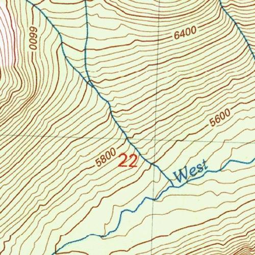
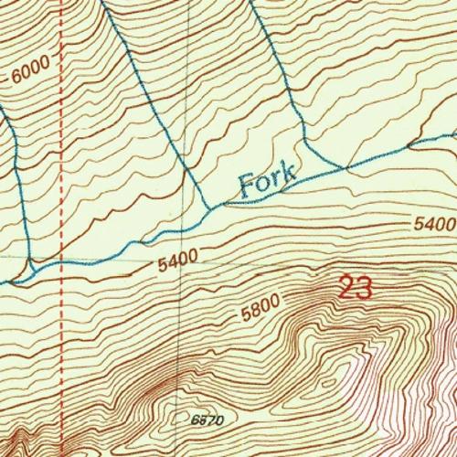
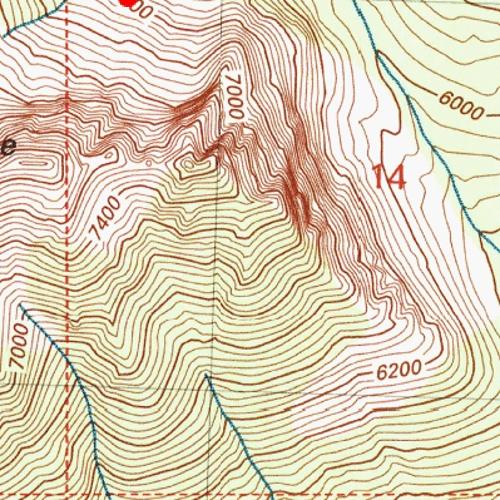
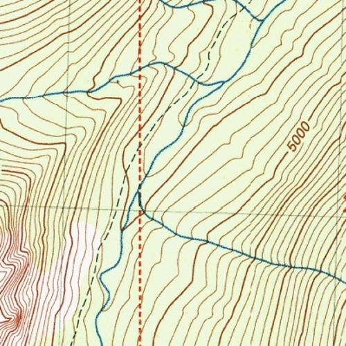
1 Report of Amy s Avalanche Prepared by Larry Goldie, NCH snow safety director A group of 2 guides were guiding 2 groups of exclusive use skiers on March 4 th, They began in Silver Star. The guides noted that there had been a widespread avalanche cycle up to size 3 in the previous 24 hours, with slides at the Saddle, Burgundy, Mambo (picture below), Red rocks, Liberty Bowl. Of note was a skier remote triggered size 1 in Liberty Bowl, as well as the extensive propagation on the slide above Mambo. After skiing in Liberty Bowl, the 2 groups were making their way back to base and decided to ski a run in Amy s. Guide 1 went there first and did some work on the landing as Guide 2 s group was being ferried over. Guide 1 s group dropped in, noting it was much more wind effected than anywhere else they had skied that day. Guide 2 came in behind Guide 1 as they had been following one another around all day. Guide 1 skied the line relatively fall line from the top landing taking the skiers left line over the lower breakover. Upon reaching the bottom, Guide 1 s group headed back to the barn while Guide 2 s group was still skiing down. At the lower breakover, Guide 2 s group

2 traversed far skiers right to the steep, dome shaped feature with a small cliff band. He told his guests to wait at the top and he proceeded to drop in. After 5-7 turns, the slope broke above him and he was swept away. Guide 2 s tracks can just be seen entering the slope just skiers right of center of the highest part of the crown. His clients organized the rescue with several starting a beacon search and one staying at the top of the slope. After running through a signal acquisition search fairly quickly they got a signal and honed in on the low point at approx. 1.5m. They hit Guide 2 with a probe strike and began digging as they had been taught that morning in the briefing. Initially they hit Guide 2 s boot. He was head down, face into the hill. When they shifted their efforts to get to his head, they found a chunk of his scalp missing and lots of bleeding from his head. They reported difficulty in getting to his face due to his pack being in the way. His face was turned away, so they began scooping snow out from in front of his face. Once they cleared the snow from in front of his face, they heard him take a big breath. After more digging, they were able to get him completely out of the snow. Estimated burial time is minutes. Of note is that while Guide 2 was skiing with an airbag pack, he had his trigger still zipped away in the shoulder strap.

3 After visiting the site, burial depth was measured at about 1 meter. (photo below) While this was happening, a NCH pilot was flying back from the barn to pick up Guide 2 s group. As he rounded the corner toward the Amy s pickup, he heard the radio traffic from Guide 2 s group, saw the avalanche and realized what was happening. He headed back to the barn to grab some guides to come back and help out. Guide 1 and another NCH guide were ready on the pad when Pilot returned and flew back out to assist in the rescue. By the time they arrived and reached the scene, Guide 2 s guests had him dug out of the snow and he was conscious. Guide 1 and the other guide treated his head wounds and cleared his spine, while the pilot flew back to get the toboggan so they could transport Guide 2 to the helicopter. Back at base, Aero Methow was initiated and were waiting there when the team was flown back. Guide 1 and one of Guide 2 s guests flew back with him, while the 3 rd guide remained at the bottom of Amy s with the other 3 guests. While the assessment of Guide 2 was quite positive based on his current state, Aero Methow decided to call Med Star to fly him to Wenatchee due to the fact that he lost consciousness for a period of time. With a likely concussion, they wanted to get him somewhere he could get a CT scan right away.

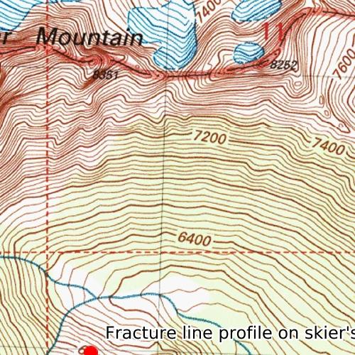
4 NCH guide staff flew up to the site on March 5 th to conduct a fracture line profile. The crown depth was 60-80cm deep, approx. 100m wide and the slide ran approx. 200 vertical meters. SS-ASu-R2/D2 O. The slide released down to the Feb 15 th crust on a layer of DF s and facets above the crust. Regionally it was a very active day on March 4 th with numerous human triggered incidents reported throughout Washington State and British Columbia. The same Feb 15 th crust and weak layer were also involved in a fatality near Whistler, BC and potentially involved in an avalanche fatality outside of Cle Elum, WA. Looking up from the recovery spot to the crown.
5
6 The NWAC Washington Pass Base station (includes precipiation and total snowdepth measurements) were not available in the days before and after this incident due to the communicaions being knocked offline. The station was eventually repaired by the WSDOT and the data is now available. From 2 am on March 3 rd to 2 am on March 4 th (25 hours) the Washington Pass Base Station recorded 0.90 inches of water. The Washington Pass Base station temperature was not plotted below but the temperature peaked at 30F at 1 pm on 3/3/17 during the storm. The total snow depth sensor was damaged and not reliable during this time. The Harts Pass Snotel total snowdepth sensor increased 10 inches during the same 25 hour window. Northwest Avalanche Center


7 East Slopes North - Canadian Border to Lake Chelan Issued: 8:27 PM PST Friday, March 3, 2017 by Garth Ferber NWAC avalanche forecasts apply to backcountry avalanche terrain in the Olympics, Washington Cascades and Mt Hood area. These forecasts do not apply to developed ski areas, avalanche terrain affecting highways and higher terrain on the volcanic peaks above the Cascade crest level. The Bottom Line: The avalanche danger should decrease on Saturday but the decrease will be a moving target and careful snowpack evaluation and cautious routefinding will be essential. Elevation Saturday Outlook for Sunday Above Treeline Considerable Near Treeline Considerable Below Treeline Moderate Dangerous avalanche conditions. Careful snowpack evaluation, cautious route-finding and conservative decision-making essential. Moderate Dangerous avalanche conditions. Careful snowpack evaluation, cautious route-finding and conservative decision-making essential. Moderate Heightened avalanche conditions on specific terrain features. Evaluate snow and terrain carefully; identify problem features. Moderate Avalanche Problems for Saturday Wind Slab Wind slabs can take up to a week to stabilize. They are confined to lee and cross-loaded terrain features and can be avoided by sticking to sheltered or wind scoured areas. Avalanche Problem Aspect/Elevation Likelihood Size Storm Slabs Storm slabs usually stabilize within a few days, and release at or below the trigger point. They exist throughout the terrain, and can be avoided by waiting for the storm snow to stabilize. Avalanche Problem Aspect/Elevation Likelihood Size Cornices Cornices are easy to identify and are confined to lee and cross-loaded ridges, sub-ridges, and sharp convexities. They are easiest to trigger during periods of rapid growth (new snow and wind), rapid warming, and during rain-on-snow events. Cornices often catch people by surprise when they break farther back onto flatter areas than expected. Avalanche Problem Aspect/Elevation Likelihood Size
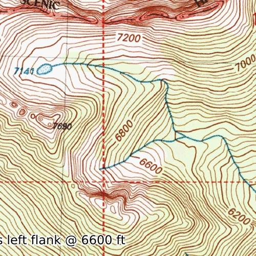
8 Snowpack Analysis Weather and Snowpack The most recent wet warm storm arrived on Valentines Day 2/14 and formed the uppermost strong rain crust in our snowpack in the Central East and Southeast Cascades while only a thin freezing rain crust was observed in the Washington Pass area. A series of disturbances in cool, NW flow aloft from Saturday 2/25 through Tuesday 2/28 deposited 2-16 inches snow along the east slopes of the Cascades. Very strong alpine west winds were seen in most of the Olympics and Cascades on Tuesday. Southwest flow aloft began to ramp up again on Thursday as the first in a new series of fronts crossed the Northwest. Strong southwest flow is carrying a second stronger front across the Northwest on Friday evening. Along the Cascade east slopes this will be causing strong southwest alpine winds and heavier moist or denser new snow above about ft and wet snow or rain below about ft. Recent Observations North A report from the NC Heli Guides indicates a cycle of natural and ski triggered wind slab avalanches during the wind event on Tuesday and Wednesday 2/28-3/1. About cm of storm snow was found with a good bond to the the Valentine's Day crust. About cm of recent snow was covering about 10 cm of wind slab in some areas. A party of four skiing at Washington Pass near the highway hairpin on the east side of the pass were hit by a natural cornice released avalanche on Tuesday afternoon. Four people were caught and carried up to 1000 ft downslope. Fortunately there were no fatalities and no full burials but there were apparently some injuries. The release occurred on a very steep slope at the top of a northeast facing bowl at about 6600 ft. Windy conditions prevented the North Cascades Heli Guides from flying on Wednesday. Another recent and large cornice failure was observed by the NCH on Thursday in the Cutthroat drainage. Plenty of other unreleased large cornices were noted. A NC Mountain Guides report for Friday for the Delancey area indicates heavy snow in the near and below treeline and cm of storm snow on the Valentine's Day crust. Moderate planar shears were found in recent storm snow layers. New storm slab was forming and ski tests were giving storm slab and loose dry releases. Whoomping and cracking was seen above 6600 ft. Central No recent observations. South No recent observations. Detailed Avalanche Forecast for Saturday Decreasing winds and mostly light snow showers should be seen over the Cascade east slopes on Saturday with much lower snow levels and much cooler temperatures. Not a lot of snow is expected following the front Friday but we will see how it goes. The avalanche danger should decrease on Saturday but the decrease will be a moving target and careful snowpack evaluation and cautious routefinding will be essential. Layers of recent or new wind and storm slab may need a day or more to mostly stabilize. Water may also need a day to drain from the upper snow pack below about feet. Recent moderate to strong southwest to west winds will make wind slab most likely on northwest to southeast slopes but keep an eye out on all aspects in areas of more complex terrain. Watch for firmer wind transported snow from Friday and possible deeper or covered wind transported layers such as from Tuesday. New storm slab formed on Friday may need a day to mostly stabilize on Saturday. Storm slab is most likely in area that experienced more than a few hours of rapidly accumulating snow. Avoid areas on ridges and mountain tops were a cornice might be present and avoid slopes below cornices. Mountain Weather Synopsis for Saturday & Sunday Showers have diminished through the day Saturday has the air mass has cooled, following a strong frontal passage Friday evening. The Pacific Northwest is under a cool regime once again with mostly light showers. A deep upper low pressure system is centered a few hundred miles off the Washington coast Saturday afternoon. This will keep a very cool and somewhat unstable air mass over the region over the next few days with bands of showers rotating into the area bringing periods of moderate showers at times. Only very light showers reached the east slope areas and that pattern should continue. An organized band of showers is developing along the coast Saturday afternoon and expected to renew light to moderate showers overnight and early Sunday as the upper low offshore continues moving towards the coast. Showers should again taper later Sunday as the upper trough begins moving inland across the region later
9 Sunday. Snow levels should remain generally 1000 feet or lower over the next few days. 24 Hour Quantitative Precipitation ending at 4 am Snow Level/Freezing Level in feet Location Sun Mon Hurricane Ridge Mt Baker Ski Area Washington Pass lt.25 lt.25 Stevens Pass Snoqualmie Pass Mission Ridge lt.25 lt.25 Crystal Mt Northwest Northeast Central South Day Olympics Cascades Cascades Cascades Cascades Saturday Afternoon 1500' 1000' 1000' 1500' 2000' Saturday Night - Sunday Morning 0' 0' 0' 0' 0' Sunday Afternoon 1000' 500' 500' 1000' 1500' Sunday Night 0' 0' 0' 0' 0' Easterly Flow in Passes Paradise White Pass Mt Hood Meadows Timberline Cascade Snow / Freezing Levels noted above refer to the north (approximately Mt Baker and Washington Pass), central (approximately Stevens to White Pass) and south (near Mt Hood). Freezing Level is when no precipitation is forecast. * Note that surface snow levels are common near the passes during easterly pass flow and may result in multiple snow / freezing levels. LT = less than; WE or Water equivalent is the liquid water equivalent of melted snow in hundredths of inches. As a rough approximation 1 inch of snow = about.10 inches WE, or 10 inches of snow = about 1 inch WE.

10 American Avalanche Association Forest Service National Avalanche Center Avalanche Incident Report: Short Form Occurrence Date (YYYYMMDD): and Time (HHMM): 1430 Comments: Prepared by Larry Goldie, North Cascades Heli Snow Safety Director Reporting Party Name and Address: Larry Goldie 13 Trillium rd, Winthrop, WA Avalanche Characteristics: Type: SS Aspect: NE Trigger: ASu Slope Angle: 44 Size: R 2 \ D 2 Elevation: 6800 m / ft Sliding surface (check one): In new New/old In old Ground Location: State: WA County: Okanogan Forest: Okanogan NF Peak, Mtn Pass, or Drainage: Cedar creek drainage Site Name: Amy's Lat/Lon or UTM: 10U (fracture-line profile on skier's left 6600 ft) Group Caught 1 Partially Buried Not critical Partially Buried-- Critical Completely Buried Number of People Time recovered Duration of burial Depth to Face m / ft 1 14: minutes 1 Number of people injured: 1 Number of people killed: Dimensions m / ft Average Maximum Height of Crown Face Width of Fracture 100 Vertical Fall 200 Snow Hardness Grain Type Grain Size (mm) Slab F - 1F DF and RG Weak 4F DF and FC 1.5 Layer Bed Surface K MFcr Thickness of weak layer: 2 mm / cm / in Burial involved a terrain trap? no yes type: Number of people that crossed start zone before the avalanche: 0 Location of group in relation to start zone during avalanche: high middle low below all unknown Avalanche occurred during ascent descent Subject Name Age Gender Address Phone Activity 1 M Skiing Equipment Carried Transceiver Shovel Probe Experience at Activity Unknown Novice Intermediate Advanced Expert Avalanche Training Unknown None Some Advanced Expert Signs of Instability Noted by Group Unknown None Recent avalanches Shooting cracks Collapse or whumphing Low test scores Injuries Sustained None First Aid Doctor s care Hospital Stay Fatal Extent of Injuries or Cause of Death Asphyxiation Head Trauma Spinal Injury Chest Trauma Skeletal Fractures Other: 1
11 Damage Number of Vehicles Caught:0 Number Structures Destroyed: 0 Estimated Loss: $0 Accident Summary Include: events leading to accident, group s familiarity with location, objectives, route, hazard evaluation, etc. Group was heli skiing and was on last run of day. Helicopter had recently left to take first group back to base. Second group was skiing last pitch of last run down to the pickup. Guide was skiing first, after several turns, the slope fractured above the skier and he was caught and swept off of his skis. Guide was familiar with the terrain as he had guided in the area for 25 years. Rescue Summary Include: description of initial search, report of accident, organized rescue, etc. The 4 guests watched the guide get caught and tried to keep an eye on him as long as possible. Once the debris stopped, the group began a transceiver search with one guest staying at the top of the slope for better radio comms. After running through the signal acquisition phase, they quickly got a signal and honed in to the low point at approximately 1.5m. They hit the guide with a probe strike and began digging as they had been trained for in the rescue training that morning. Initially they found his boot, but started moving toward his head to get an airway. He was face down, head turned uphill, making getting to his airway difficult. When they were able to clear snow from in front of his mouth, they heard him take a big breath. After more digging they were able to get him completely out. The helicopter returned to pick up the guide's group and saw the rescue. The pilot returned to base, picked up 2 additional guides and returned to the site. By the time they returned, the guide was on the surface and breathing. Rescue Method Attach additional pages as needed. Include weather history, snow profiles, reports from other agencies, diagram of site, photographs, and any other supporting information Please send to: CAIC; 325 Broadway WS1; Boulder CO 80305; caic@state.co.us and to the nearest Avalanche Center. Self rescue Transceiver Spot probe Probe line Rescue dog Voice Object Digging Other: 2
Rooster Comb Ridge Cornice Incident
 Rooster Comb Ridge Cornice Incident April 3, 2011 Date/time: Sunday, April 3, 2011 / ~12:45pm PDT Submitted by: Patty Morrison Stevens Pass Winter Resort Snow Safety; Mark Moore NWAC Place: High point
Comments and photos from Andrew Toyota (Everett Mountain Rescue):
:") Date: 13 April 2013 Location: Red Mountain, Snoqualmie Pass, WA Accident: several persons partly or completely buried, 1 fatality Submitted by: Garth Ferber and Dennis D Amico (Northwest Avalanche Center)
Date: 13 April 2013 Location: Red Mountain, Snoqualmie Pass, WA Accident: several persons partly or completely buried, 1 fatality Submitted by: Garth Ferber and Dennis D Amico (Northwest Avalanche Center)
Alpental Ski Area Back Country WAC Bluffs Avalanche Accident
 Preliminary Alpental Ski Area Back Country WAC Bluffs Avalanche Accident February 19, 2012 Time and Date: ~1145 AM PST, 2/19/2012 Submitted by: Aaron Opp (Snoqualmie Pass Professional Ski Patrol) and Mark
Paradise, Mt Rainier Avalanche Incident
 Page 1 of 6 Paradise, Mt Rainier Avalanche Incident January 1, 2003, 1345 PST [Report prepared by Mark Moore, NWAC] Location: Upper Golden Gate Trail Avalanche Specifics: SS-AO-3 (US Classification), 3-4
Avalanche Accident Report for April 11, 2001 near Mt Baker, Washington One snowmobiler caught, buried and killed
 Page 1 of 8 Avalanche Accident Report for April 11, 2001 near Mt Baker, Washington One snowmobiler caught, buried and killed South side of Mt. Baker, Snowmobile Avalanche-Fatality Report Report prepared
Crystal Mountain Employee Housing Chutes Avalanche Accident Crystal Mountain, WA February 17, 2001
 Page 1 of 9 Crystal Mountain Employee Housing Chutes Avalanche Accident Crystal Mountain, WA February 17, 2001 Summary One out of bounds skier triggered and caught by slide, swept through trees, partially
Tunnel Creek Avalanche Incident
 PRELIMINARY REPORT Tunnel Creek Avalanche Incident February 19, 2012 Time and Date: 1200 noon, 2/19/2012 Submitted by: Patty Morrison and Jamie Owens (Stevens Pass Professional Ski Patrol) and Mark Moore
FACETED SNOW AND DEEP SLAB INSTABILITIES IN THE MARITIME CLIMATE OF THE CASCADES. Jon Andrews* Stevens Pass Ski Area
 FACETED SNOW AND DEEP SLAB INSTABILITIES IN THE MARITIME CLIMATE OF THE CASCADES Jon Andrews* Stevens Pass Ski Area ABSTRACT: Forecasting for deep slab instabilities in dense, deep snow can be tricky,
Little Zigzag Canyon, Mt. Hood Accident
 Body Page 1 Little Zigzag Canyon, Mt. Hood Accident 3-17-14 Date: 3-17-14 Location: Little Zigzag Canyon, near PCT crossing, Mt. Hood Number in Party: 2 Number caught: 1, completely buried Number hurt:
Source/Snow Lake Trail Avalanche Accident December 2, 2007
 Preliminary Report Source/Snow Lake Trail Avalanche Accident December 2, 2007 Accident Summary Time: 2 nd December 2007, approximately 15:00 hrs Location: Near Source Lake, Snoqualmie Pass WA Activity:
Teen snowmobiler dies in Okanogan avalanche
 Avalanche incident claims one snowmobiler in Washington Summary Date/Time of incident: 3-19-2006, ~2 PM Location: Above Brown s Meadow near Tiffany Mountain; approximately 12 miles NE of Conconully, Okanogan
How to assess a snowpack with your group:
 This avalanche awareness curriculum was produced in partnership between the Colorado Mountain Club s Conservation Department s Backcountry Snowsports Initiative and Youth Education Program as well as the
Proceedings, International Snow Science Workshop, Innsbruck, Austria, 2018
 RELEASE OF AVALANCHES ON PERSISTENT WEAK LAYERS IN RELATION TO LOADING EVENTS IN COLORADO, USA Jason Konigsberg 1, Spencer Logan 1, and Ethan Greene 1 1 Colorado Avalanche Information Center, Boulder,
Avalanche Fatality on Mt. Hermann near Mt Baker, WA
 Avalanche Fatality on Mt. Hermann near Mt Baker, WA ~0830 AM, Tuesday, April 18 th, 2006 Location of incident Stoneman s chute off Mt. Hermann near Mt Baker, WA Number in party 3; 1 skier caught and killed
Major Winter Storm to impact Western Washington. 17 January 2012 National Weather Service Seattle/Tacoma
 Major Winter Storm to impact Western Washington 17 January 2012 National Weather Service Seattle/Tacoma Current Warnings Winter Storm Warning for all of Western Washington, except: Northwest interior Extreme
MET Lecture 20 Mountain Snowstorms (CH16)
") MET 4300 Lecture 20 Mountain Snowstorms (CH16) Learning Objectives Provide an overview of the importance and impacts of mountain snowstorms in the western US Describe how topography influence precipitation
MET 4300 Lecture 20 Mountain Snowstorms (CH16) Learning Objectives Provide an overview of the importance and impacts of mountain snowstorms in the western US Describe how topography influence precipitation
Northwest Weather & Avalanche Center Annual Report June, 2001 Report Prepared by Mark Moore, Garth Ferber and Kenny Kramer
 Northwest Weather & Avalanche Center 2000-2001 Annual Report June, 2001 Report Prepared by Mark Moore, Garth Ferber and Kenny Kramer A partnership between the USDA Forest Service, Washington State Department
Avalanche on Newberry Crater. A firsthand account of a snowmobiler avalanche accident and the SUbsequent rescue-january 15,1998
 Avalanche on Newberry Crater A firsthand account of a snowmobiler avalanche accident and the SUbsequent rescue-january 15,1998 Brian Sali 1 and Art Keys ISSW Paper Summary prepared by Pam Hayes and Mark
Jan 7, 2017 Winter Weather Event
 Jan 7, 2017 Winter Weather Event Decision Support Briefing # 5 Assessment for northeast South Carolina & southeast North Carolina National Weather Service Wilmington NC 4 PM EST Friday January 6, 2017
3 Severe Weather. Critical Thinking
 CHAPTER 2 3 Severe Weather SECTION Understanding Weather BEFORE YOU READ After you read this section, you should be able to answer these questions: What are some types of severe weather? How can you stay
Guided Notes Weather. Part 2: Meteorology Air Masses Fronts Weather Maps Storms Storm Preparation
 Guided Notes Weather Part 2: Meteorology Air Masses Fronts Weather Maps Storms Storm Preparation The map below shows North America and its surrounding bodies of water. Country borders are shown. On the
TFS WEATHER BRIEF. Monday, March 25
 TFS WEATHER BRIEF Monday, March 25 Review: The leading edge of cooler and drier air was pushing through Central and East TX this morning. A few lingering thunderstorms were in progress south of I-20 in
IWT Scenario 1 Integrated Warning Team Workshop National Weather Service Albany, NY October 31, 2014
 Integrated Warning Team Workshop National Weather Service Albany, NY October 31, 2014 23 24 25 26 27 Scenario 1 Timeline November 23-27 Sun Mon Tue Wed Thu Thanksgiving Day Sunday, Nov. 23 @ 430 pm NWS
FORECASTING FOR A HELICOPTER SKIING OPERATION IN THE UNITED STATES. High Mountain Heli-Skiing P.O. Box 2221 Jackson Hole, WY ABSTRACT
 AVALANCHE FORECASTING FOR A HELICOPTER SKIING OPERATION IN THE UNITED STATES Jim Woodrnencey 1 and Jon Shick 2 High Mountain Heli-Skiing P.O. Box 2221 Jackson Hole, WY 83001 ABSTRACT Helicopter skiing
Initial Report. North Central Texas Initial Attack. Hildreth Road Dozer Accident. February 9, 2006
 6.152 February 17, 2006 Initial Report North Central Texas Initial Attack Hildreth Road Dozer Accident February 9, 2006 This report is intended to inform interested parties, for a safety and training tool,
California OES Weather Threat Briefing
 California OES Weather Threat Briefing Wednesday, January 16, 2019 9:00 AM PST Day 1: Strong winds, heavy mountain snow and heavy rain with isolated thunderstorms across much of the state through Thursday
Weather Briefing for Pennsylvania January 5-8, 2014 Prepared 01/05/14 (1:30 PM EST)
") Weather Briefing for Pennsylvania January 5-8, 2014 Prepared 01/05/14 (1:30 PM EST) Prepared by: National Weather Service State College, PA (john.lacorte@noaa.gov) Latest Radar Latest Surface Weather Plots
Weather Briefing for Pennsylvania January 5-8, 2014 Prepared 01/05/14 (1:30 PM EST) Prepared by: National Weather Service State College, PA (john.lacorte@noaa.gov) Latest Radar Latest Surface Weather Plots
A Prepared Marylander Creates a Resilient Maryland
 Maryland Emergency Management Agency Operations Directorate Hazardous Winter Weather Outlook Briefing March 5, 2013 0800 A Prepared Marylander Creates a Resilient Maryland A strong low pressure will track
Whistler Mountain is located at about 50 0 North latitude by 123 0
 - 24 - WHISTLER MOUNTAIN AVALANCHE CONTROL PROGRAMME C. Stethem and J. Hetherington Introduction Whistler Mountain is located at about 50 0 North latitude by 123 0 longitude, in the Pacific Coast Range
What Are Disasters? The Rescue Kids Trio!
 The Rescue Kids Trio! What Are Disasters? This manual was made possible through funding by the Council of Local Authorities for International Relations. Disasters and emergency preparedness Emergency preparedness
TROPICAL STORM HARVEY COE Navigation Call - Update
 TROPICAL STORM HARVEY COE Navigation Call - Update 10:00 AM CDT Tuesday, August 29, 2017 Prepared by: NWS LIX NWSNewOrleans www.weather.gov/neworleans Situation Overview New Information Drifting ENE at
Northwest Weather and Avalanche Center
 Northwest Weather and Avalanche Center 22-23 Annual Report May 23 Report Prepared by Mark Moore, Garth Ferber and Kenny Kramer A partnership between the USDA Forest Service, Washington State Department
Foundations of Earth Science, 6e Lutgens, Tarbuck, & Tasa
 Foundations of Earth Science, 6e Lutgens, Tarbuck, & Tasa Weather Patterns and Severe Weather Foundations, 6e - Chapter 14 Stan Hatfield Southwestern Illinois College Air masses Characteristics Large body
HURRICANE HARVEY COE Navigation BRIEFING
 HURRICANE HARVEY COE Navigation BRIEFING 10:00 AM CDT Friday, August 25, 2017 NWSNewOrleans www.weather.gov/neworleans Situation Overview New Information Harvey continues to strengthen Max sustained winds
August 2006 Summary. August 1-5
 Ashley Brooks (765) 494-6574 Sep 8, 2006 http://www.iclimate.org August 1-5 August 2006 Summary The heat wave that started during the end of July continued into the beginning parts of August with temperatures
Issued by: National Weather Service San Joaquin Valley - Hanford CA. Issue time: 409 AM PST Wed Jan
 Forecast Information Location: New_Exchequer_Dam Updated: January 16, 2019, 11:45 am NWS Weather Discussion: Issued by: National Weather Service San Joaquin Valley - Hanford CA Issue time: 409 AM PST Wed
Weekly Weather Briefing. NWS Albuquerque. Wet, Then Dry, Then Wet. NWS Albuquerque August 4, Weekly Weather Briefing
 Weekly Weather Briefing Weekly Weather Briefing Wet, Then Dry, Then Wet August 4, 2014 Weekly Weather Briefing Most Recent Temperatures Weekly Weather Briefing Today s Max Temp Departure from Normal Weekly
January 2008 Climate Summary
 Joseph Mays (765) 494-6574 Feb 5, 2008 http://www.iclimate.org Summary January 2008 Climate Summary January was a mix bag of conditions, with an oscillatory pattern developing. We experienced phases of
Natural Disasters. Why Are There Earthquakes? 197 words. The Power of the Earth 221 words. Big Waves! 188 words
 ARTICLE-A-DAY Natural Disasters 6 Articles Check articles you have read: Why Are There Earthquakes? 197 words The Power of the Earth 221 words Big Waves! 188 words The Volcano That Keeps Erupting 228 words
Glossary Accuracy precision Alpha Angle crown face Anemometer Aspect fall line Atmospheric Pressure barometric pressure Avalanche, Snow
 Glossary Glossary Accuracy The difference between the measured value and the actual or true value. A property of a measurement method and instruments used. Also see precision. Alpha Angle The angle between
Office of the Washington State Climatologist
 Office of the Washington State Climatologist May 3, 2013 April Event Summary Average April temperatures were below normal for a majority of the state. Total precipitation was above normal for western and
WEATHER NOTIFICATION STATEMENT
 WEATHER NOTIFICATION STATEMENT NEW DATA SHOWS SNOWSTORM THREAT FOR JAN 13-14 LOOKS MUCH HEAVIER BIGGER COVERAGE northwest NC (ice) ALL OF VA (Except Hampton Roads) all of MD/ DEL eastern southern PA southern
Forecasting Challenges
 Forecasting Challenges 2017-18 Alex Tardy- NWS San Diego Alexander.Tardy@noaa.gov CW3E meetings April 2018 Atmospheric Rivers Climate Forecast System by NOAA 100-h fuel moisture all-time low for South
PRELIMINARY Scout Patrol Peak Avalanche Accident
 PRELIMINARY Scout Patrol Peak Avalanche Accident January 1, 2012 Time and Date: approximately 1130 AM, 1-1-2012 Submitted by: Bryan Kraai, Craig Willis (and Mark Moore NWAC) Place: North flank of Scout
MONITORING SNOWPACK TEMPERATURE GRADIENT USING AUTOMATIC SNOW DEPTH SENSOR
 MONITORING SNOWPACK TEMPERATURE GRADIENT USING AUTOMATIC SNOW DEPTH SENSOR Örn Ingólfsson* POLS Engineering, IS-400 Ísafjörður, ICELAND Harpa Grímsdóttir, Magni Hreinn Jónsson Icelandic Meteorological
Key Concept Weather results from the movement of air masses that differ in temperature and humidity.
 Section 2 Fronts and Weather Key Concept Weather results from the movement of air masses that differ in temperature and humidity. What You Will Learn Differences in pressure, temperature, air movement,
January 2006 Climate Summary
 Ashley Brooks (765) 494-6574 Feb 9, 2006 http://www.iclimate.org January 1-3 January 2006 Climate Summary Unseasonably warm conditions welcomed in the New Year with highs in the 40s across the northern
WEATHER SYSTEMS IMPACTING THE CAYMAN ISLANDS Prepared by the staff of the Cayman Islands National Weather Service
 WEATHER SYSTEMS IMPACTING THE CAYMAN ISLANDS 2008 Prepared by the staff of the Cayman Islands National Weather Service TROPICAL STORM DOLLY Formed 194 miles west of Grand Cayman July 19 th. The tropical
IWT Scenario 2 Integrated Warning Team Workshop National Weather Service Albany, NY October 31, 2014
 IWT Scenario 2 Integrated Warning Team Workshop National Weather Service Albany, NY October 31, 2014 09 10 11 12 13 Scenario 2 Timeline December 9-13 Tue Wed Thu Fri Sat Tue, Dec. 9 @ 5 am 2014 2014 2014
4/29/2011. Mid-latitude cyclones form along a
 Chapter 10: Cyclones: East of the Rocky Mountain Extratropical Cyclones Environment prior to the development of the Cyclone Initial Development of the Extratropical Cyclone Early Weather Along the Fronts
Investigation of the Arizona Severe Weather Event of August 8 th, 1997
 Investigation of the Arizona Severe Weather Event of August 8 th, 1997 Tim Hollfelder May 10 th, 2006 Abstract Synoptic scale forcings were very weak for these thunderstorms on August 7-8, 1997 over the
Spring Water Supply and Weather Outlook How about that near Miracle March?
 Spring Water Supply and Weather Outlook How about that near Miracle March? tim.bardsley@noaa.gov NWS Reno 4.10.18 1 Out the Window March and early April have been Boom not Bust Key Points Up Front Wet
East Greenland Coming to Greenland it is all about the experience of the Arctic!
 East Greenland 2015 The heliski area is on the East Coast in a region named Angmagssalik. The mountain ranges are between large fiords coming off the Greenland ice cap. The highest peaks in the region
TROPICAL STORM HARVEY BRIEFING
 TROPICAL STORM HARVEY BRIEFING 2:00 PM CDT Tuesday, August 29, 2017 Prepared by: NWS LIX NWSNewOrleans www.weather.gov/neworleans Situation Overview New Information Moving NNE Max sustained wind 45 mph
WEEKLY WEATHER OUTLOOK BELIZE, CENTRAL AMERICA
 WEEKLY WEATHER OUTLOOK BELIZE, CENTRAL AMERICA PERIOD: Sunday, July 1 until Monday, July 9, 2012 DATE ISSUED: Sunday, July 1, 2012 3:00 pm RFrutos EcoSolutions & Services SYNOPSIS: The features of interest
Thanksgiving Snow and Arctic Front 25 November 2005 By Richard H. Grumm National Weather Service State College, PA 16801
 Thanksgiving Snow and Arctic Front 25 November 2005 By Richard H. Grumm National Weather Service State College, PA 16801 1. INTRODUCTION An approaching arctic front brought light snow to most of western
Weather and Climate 1. Elements of the weather
 Weather and Climate 1 affect = to have an effect on, influence, change altitude = the height of a place above the sea axis = the line around which an object rotates certain = special consist of = to be
photo courtesy of
 BRITISH VIRGIN ISLANDS REPORT TROPICAL STORM JEANNE photo courtesy of www.bviplatinum.com PREPARED BY THE DEPARTMENT OF DISASTER MANAGEMENT 1 EVENT 13 th -16 th September, 2004 TROPICAL STORM JEANNE Sequence
HURRICANE IRMA. 12 PM ET Saturday, September Prepared by: Kyle Thiem / Sid King.
 HURRICANE IRMA 12 PM ET Saturday, September 9 2017 Prepared by: Kyle Thiem / Sid King www.weather.gov/atlanta/briefings @NWSAtlanta www.weather.gov/atlanta Situation Overview 11:00 AM EDT Sat Sep 9 Location:
The Propagation Saw Test (PST)
") The Propagation Saw Test (PST) Dave Gauthier 1 (davidmgauthier@gmail.com) and Bruce Jamieson 1,2 1 Dept. of Civil Engineering, University of Calgary 2 Dept. of Geoscience, University of Calgary Introduction:
The Propagation Saw Test (PST) Dave Gauthier 1 (davidmgauthier@gmail.com) and Bruce Jamieson 1,2 1 Dept. of Civil Engineering, University of Calgary 2 Dept. of Geoscience, University of Calgary Introduction:
BACKPACKING vs. WX MOUNTAIN WEATHER. READING WX s SIGNS PREDICTING WEATHER RESOURCES SUMMARY
 1 BACKPACKING vs. WX MOUNTAIN WEATHER READING WX s SIGNS PREDICTING WEATHER RESOURCES SUMMARY 3 I M TRAPPED WEST SIDE EAST SIDE AIR GETS COLDER AS IT RISES o ADD 4 DEGREES PER -1000 FEET OF ALTITUDE LOSS
1st Annual Southwest Ohio Snow Conference April 8, 2010 Abner F. Johnson, Office of Maintenance - RWIS Coordinator
 1st Annual Southwest Ohio Snow Conference April 8, 2010 Abner F. Johnson, Office of Maintenance - RWIS Coordinator The Ohio Department of Transportation ODOT has approximately 5500 full-time employees
September 2005 Climate Summary
 Ashley Brooks (765) 494-6574 Oct 5, 2005 http://iclimate.org September 2005 Climate Summary September 1-7 A cold front came through on the 1 st of the month, however little moisture was associated with
Changes to Land 5.7B. landforms: features on the surface of Earth such as mountains, hills, dunes, oceans and rivers
 All the landforms on Earth have changed over time and continue to change. Many of the changes were caused by wind, moving water, and moving ice. Mountains have grown and shrunk. Rivers have cut away land
HURRICANES AND TORNADOES
 HURRICANES AND TORNADOES The most severe weather systems are hurricanes and tornadoes. They occur in extremely low pressure systems, or cyclones, when the air spirals rapidly into the center of a low.
AVALANCHE HAZARD EVALUATION IN HELICOPTER SKIING. Hans Gmoser Canadian Mountain Holidays, Banff, Alberta. Introduction
 90 AVALANCHE HAZARD EVALUATION IN HELICOPTER SKIING Hans Gmoser Canadian Mountain Holidays, Banff, Alberta Introduction I delivered a paper at the previous Avalanche Workshop-in 1976 comparing the avalanche
NIDIS Drought and Water Assessment
 NIDIS Drought and Water Assessment PRECIPITATION The images above use daily precipitation statistics from NWS COOP, CoCoRaHS, and CoAgMet stations. From top to bottom, and left to right: most recent 7-days
Think about the landforms where you live. How do you think they have changed over time? How do you think they will change in the future?
 reflect All the landforms on Earth have changed over time and continue to change. Many of the changes were caused by wind, moving water, and moving ice. Mountains have grown and shrunk. Rivers have cut
Beyond the Book. FOCUS Book
 FOCUS Book Suppose your city wants to build a new housing development on a steep slope outside town. Design a model to test whether the land is safe from the types of landslides you read about in this
Jan 7, 2017 Winter Weather Event
 Jan 7, 2017 Winter Weather Event Decision Support Briefing # 4 Assessment for northeast South Carolina & southeast North Carolina National Weather Service Wilmington NC 8 AM EST Friday January 6, 2017
The Pennsylvania Observer
 The Pennsylvania Observer September 3, 2008 Summer 2008 Weather Summary Written by: Brian Thompson The opening days of June started dry, but a warm front brought a widespread rain a couple of days into
Summary of November Central U.S. Winter Storm By Christopher Hedge
 Summary of November 12-13 2010 Central U.S. Winter Storm By Christopher Hedge Event Overview The first significant snowfall of the 2010-2011 season affected portions of the plains and upper Mississippi
NATIONAL WEATHER SERVICE
 January 2016 February 9, 2016 This was a dry month across the HSA despite one large and several smaller snowfalls. Most locations ended up 1-2 inches below normal for the month. The driest locations at
LECTURE #15: Thunderstorms & Lightning Hazards
 GEOL 0820 Ramsey Natural Disasters Spring, 2018 LECTURE #15: Thunderstorms & Lightning Hazards Date: 1 March 2018 (lecturer: Dr. Shawn Wright) I. Severe Weather Hazards focus for next few weeks o somewhat
Atmospheric River Simulation
 Atmospheric River Simulation One of the most impressive AR setups forecasters have seen in years Saturday AM Saturday PM Sunday AM Sunday PM Peak intensity! Integrated Vapor Transport (wind energy + moisture)
Multiple Choice Identify the choice that best completes the statement or answers the question.
 CH.15 practice TEST Multiple Choice Identify the choice that best completes the statement or answers the question. 1) The short-term state of the atmosphere is called a) climate. c) water cycle. b) weather.
Custom Weather Forecast
 1 of 23 Custom Weather Forecast 2018 Chicago Yacht Club s Race To Mackinac- Cruising Division Disclaimer: The user assumes all risk related to the use of this Custom Weather Forecast. The crew of the participating
Tropical Update. 5 AM EDT Thursday, September 7, 2017 Hurricane Irma, Hurricane Jose, and Hurricane Katia
 Tropical Update 5 AM EDT Thursday, September 7, 2017 Hurricane Irma, Hurricane Jose, and Hurricane Katia This update is intended for government and emergency response officials, and is provided for informational
Weather and Climate Summary and Forecast April 2018 Report
 Weather and Climate Summary and Forecast April 2018 Report Gregory V. Jones Linfield College April 4, 2018 Summary: A near Miracle March played out bringing cooler and wetter conditions to the majority
Tropical Update. 5 PM EDT Thursday, September 7, 2017 Hurricane Irma, Hurricane Jose, and Hurricane Katia
 Tropical Update 5 PM EDT Thursday, September 7, 2017 Hurricane Irma, Hurricane Jose, and Hurricane Katia This update is intended for government and emergency response officials, and is provided for informational
TROPICAL STORM HARVEY BRIEFING
 TROPICAL STORM HARVEY BRIEFING 10:00 AM CDT Sunday, August 27, 2017 Prepared by: NWS LIX NWSNewOrleans www.weather.gov/neworleans Situation Overview New Information Tropical Storm Winds 40mph Immediate
Severe Weather Potential for Southeast Texas
 Severe Weather Potential for Southeast Texas Dan Reilly, Kent Prochazka, Scott Overpeck National Weather Service Houston/Galveston 10 am Synopsis Storm to likely bring severe weather to Southeast Texas
Preliminary Summary Report of Serious or Near Serious CAL FIRE Injuries, Illnesses and Accidents GREEN SHEET. Near Serious Accident 12/9/2017
 Preliminary Summary Report of Serious or Near Serious CAL FIRE Injuries, Illnesses and Accidents GREEN SHEET Near Serious Accident 12/9/2017 Thomas Incident 17-CA-VNC-103156 California Southern Region
Persistent Slab Avalanches
 Persistent Slab Avalanches Introduction Persistent slab avalanches are caused by a cohesive slab of snow losing its bond to an underlying weak layer that strengthens slowly or not at all over time. These
Hurricane Matthew Threats and Impacts Briefing for Eastern NC
 Hurricane Matthew Threats and Impacts Briefing for Eastern NC October 6 th, 2016 Date/Time Created: 10/6/2016, Noon EDT National Weather Service Newport/Morehead City, NC Hurricane Matthew Key Points Changes
THE AVALANCHE SITUATION IN A SPECIAL WINTER. REVIEW OF THE 09/10 SEASON IN NORWAY
 THE AVALANCHE SITUATION IN A SPECIAL WINTER. REVIEW OF THE 09/10 SEASON IN NORWAY Christian Jaedicke*, Kjetil Brattlien, Regula Frauenfelder, Krister Kristensen, Kalle Kronholm Norwegian Geotechnical Institute,
Your Task: Read each slide then use the underlined red or underlined information to fill in your organizer.
 Severe Weather: Tornadoes and Hurricanes Thunderstorms and Lightning S6E4 d. Construct an explanation of the relationship between air pressure, weather fronts, and air masses and meteorological events
- SNOW - DEPOSITION, WIND TRANSPORT, METAMORPHISM
 ESS 431 PRINCIPLES OF GLACIOLOGY ESS 505 THE CRYOSPHERE - SNOW - DEPOSITION, WIND TRANSPORT, METAMORPHISM OCTOBER 10, 2016 Ed Waddington edw@uw.edu Homework Skating and the phase diagram See web page Sources
MOUNTAIN SKILLS: HOW TO REALLY READ THE AVALANCHE FORECAST
 Page 1 of 8 SEARCH THIS WEBSITE HOME GEAR PHOTOS BACKCOUNTRY TV STORIES MOUNTAIN SKILLS MAGAZINE SHOP BASECAMP SUBSCRIBE WIN FREE GEAR MOUNTAIN SKILLS: HOW TO REALLY READ THE AVALANCHE FORECAST BY SARAH
Avalanches. Avalanche s
 Avalanches Avalanche s Avalanches were first imagined as giant snowballs which increased in size from accretion of underlying snow What are avalanches? They are flows which move under the influence of
Natural Disasters PASSAGE 5
 PASSAGE 5 Name Directions: Read Natural Disasters. Then answer questions 1 8. Natural Disasters Our planet can be a calm place, but weather conditions often change rapidly. Gentle breezes can blow into
Glide avalanche response to an extreme rain-on-snow event, Snoqualmie Pass, Washington, USA 2 METHODS
 Glide avalanche response to an extreme rain-on-snow event, Snoqualmie Pass, Washington, USA John Stimberis 1 * and Charles M. Rubin 2 1 Washington State Department of Transportation, Snoqualmie Pass, WA,
Northwest Weather and Avalanche Center
 Northwest Weather and Avalanche Center 23-24 Annual Report Report prepared by Garth Ferber, Kenny Kramer and Mark Moore A partnership between the USDA Forest Service, Washington State Parks and Recreation
WEEKLY OUTLOOK Valid: June 24-July 1, 2013
 WEEKLY OUTLOOK Valid: June 24-July 1, 2013 Issue: 6:00 am Tuesday, June 24, 2013 SYNOPSIS for 6:00am Tuesday, June 24, 2013 RESIDUAL INSTABILITY IN THE MOIST EASTERLY AIRFLOW INDUCED BY A SHORT-WAVE TROUGH
PRECIPITATION. Last Week Precipitation:
 12/3/2014 NIDIS Drought and Water Assessment PRECIPITATION The images above use daily precipitation statistics from NWS COOP, CoCoRaHS, and CoAgMet stations. From top to bottom, and left to right: most
Weekly Weather Briefing. NWS Albuquerque. Severe Threat Central & East through Tonight, then Drying. NWS Albuquerque September 29, 2014
 Severe Threat Central & East through Tonight, then Drying September 29, 2014 Today s Max Temp Departure from Normal Notable Severe Weather Events in September* September 30, 1998 Los Lunas: 4.5 Hail*
Weather Briefing for Pennsylvania Feb Outlook Prepared 02/11/14 2 pm EST
 Weather Briefing for Pennsylvania Feb. 12-13 Outlook Prepared 02/11/14 2 pm EST Prepared by: National Weather Service State College, PA (Peter.Jung@noaa.gov) Pennsylvania Weather Overview A significant
Weekly Weather Briefing. NWS Albuquerque. Tuesday Soaker. NWS Albuquerque August 25, Weekly Weather Briefing
 Weekly Weather Briefing Weekly Weather Briefing Tuesday Soaker August 25, 2014 August 2014 vs. 2013 Precipitation Percent of Average August 1-24, 2014 August 2013 Weekly Weather Briefing ABQ **Preliminary**
Haslingden High School Geography Department HOMEWORK BOOKLET Year 8 Block C
 Haslingden High School Geography Department HOMEWORK BOOKLET Year 8 Block C Name: Form: Subject Teacher: Date Given: Date to Hand in: Level: Effort: House Points: Comment: Target: Parent / Guardian Comment:
National Situation Report As of 5:00 a.m. EDT Tuesday, April 4, 2017
 Overview National Situation Report As of 5:00 a.m. EDT Tuesday, April 4, 2017 Table Of Contents Current Operations Monitoring Recovery National Response Coordination Center: Not Activated National Watch