NOAA s National Weather Service Advanced Hydrologic Prediction System (AHPS) and Inclusion of Reservoir Spills
|
|
|
- Basil Jackson
- 5 years ago
- Views:
Transcription
1 NOAA s National Weather Service Advanced Hydrologic Prediction System (AHPS) and Inclusion of Reservoir Spills Peter R. Ahnert Middle Atlantic River Forecast Center, State College PA
2 Topics Covered Mission Delaware Basin Overview Flood Forecasting/Warning Overview How Do You Get a 100 Year Flood? Snow/Rain Maps Summary of NWS Products Flood Loss Reductions from Flood Warnings Web Access to Products Reservoir Impacts
3 NOAA s NWS Mission Statement The National Weather Service (NWS) provides weather, hydrologic, and climate ecasts and warnings the United States, its territories, adjacent waters and ocean areas, the protection of life and property and the enhancement of the national economy.
4 Mission of Mid-Atlantic River Forecast Center The Middle Atlantic River Forecast Center produces timely and accurate water ecasts and inmation using the best scientific principles to integrate and model water, weather, and climate inmation.

5 MARFC AREA

6 Delaware River Basin Background: Longest un-dammed river east of the Mississippi Main stem 330 miles in length Drainage area - 13,539 square miles Includes PA, NY, NJ, and DE Provide 5% of the nations drinking water Provide NYC with 50% of its drinking water Accessible within a short drive to 20% of the people living in the U.S.

7 Delaware River Basin Flood History: Major Flooding recorded since 1839 Snowmelt: 1839, 1841, 1846, 1936, 1996 Severe Rainfall: 1850, 1862, 1942, 1975, 2005 Northeasters: 1869 Tropical Systems: 1933, 1938, 1955, 1972, 1996, 1999, 2001, 2004

8 Upper Delaware Rain Gages

9 Upper Delaware Rain Gages

10 Modeling Schematic

11 River Flood Warning in the Delaware Basin Data collected from federal and state cooperators and volunteer observers Middle Atlantic RFC models river systems to ecast river stages and flows NWS ecast offices at Binghamton, NY and Mt Holly, NJ issue ecasts and warnings NWS river and flood ecasts disseminated via NOAA Weather Radio, media outlets, Internet
12 Stream Gages and Flood Forecast Points in the Delaware River Basin 160 continuous record stream gages 118 gages have satellite telemetry 46 Flood Forecast Points ## # # # # # ## # # # # ## # # # $Z $Z $Z $Z $Z # # ## # # $Z # # # # ### $Z $Z # # # $Z # $Z $Z # # # # $Z ## # $Z # $Z ## # $Z # # ## $Z ## $Z # ## # $Z # $Z # $Z$Z$Z $Z # # $Z # # # # ## $Z$Z # ### # # $Z # # $Z$Z ## $Z $Z ## # # # # # # ## # # # $Z $Z$Z $Z ## ## # # # # $Z$Z$Z ## $Z # # # $Z ## # # $Z$Z # $Z # ## ## # # # $Z$Z $Z # # # # # # # # # # # #
13 100 Year Flood (from USGS) Fact Sheet Why Don't These Floods Happen Every 100 Years? The term "100-year flood" is misleading because it leads people to believe that it happens only once every 100 years. The truth is that an uncommonly big flood can happen any year There is a 1-in-100 chance that a flood this size will happen during any year. Perhaps a better term would be the "1- in-100 chance flood."
14 100 Year Flood What Does It Take To Get One? Usually preceeded by a wet period lasting months that sets the stage or an above normal snowpack. Often preceeded a few days bee by a precursor flood event that results in very wet soils and above normal river levels. Requires unusually heavy rain covering most of the river basin.
15 100 Year Flood What Does It Take To Get One? In Summary, it takes an unusual set of conditions that come together in an unusual sequence, at an unusual time and place to produce a rare event

16 Setting the Stage 365 Day Precipitation Departures
17 Setting the Stage 30 Day Precipitation Departures

18 Setting the Stage Snow Water Equivalent 4/1/05

19 Precursor Event 24 Hr Pcpn ending 7 am 3/29/05

20 100 Year Flood 24 Hr Pcpn ending 1 pm 3/29/05
21 100 Year Flood Snow Water Equivalent 4/3/05

22 Widespread Heavy Rain 24 Hr Pcpn ending 7 am 4/3/05

23 100 Year Flood 24 Hr Pcpn ending 1 pm 4/2/05

24 100 Year Flood 24 Hr Pcpn ending 1 pm 4/3/05

25 Widespread Heavy Rain Rainfall Total March 28 April 4, 2005
26 Summary of National Weather Service Products
27 16 Days Bee WINTER/SPRING RIVER FLOOD POTENTIAL OUTLOOK THURSDAY, MARCH 17, 2005 MIDDLE ATLANTIC RIVER FORECAST CENTER THE HIGHEST THREAT OF RIVER FLOODING DURING THE NEXT TWO WEEKS IS ACROSS THE NEW YORK AND NORTHERN PENNSYLVANIA BASINS DUE TO WET SOILS AND A DECENT SNOWPACK AND WHILE NOT PRESENTLY FORESEEN, WARM AND/OR WET WEATHER COULD ARRIVE ACROSS THE NORTH DURING THE SECOND HALF OF THIS OUTLOOK PERIOD, WHICH COULD RATHER EASILY RESULT IN SOME RIVER FLOODING DEVELOPING...
28 HYDROLOGIC OUTLOOK 3 Days Bee Hydrologic Outlook NATIONAL WEATHER SERVICE BINGHAMTON NY 225 PM EST WED MAR PERIODS OF RAIN ARE POSSIBLE LATE FRIDAY NIGHT AND SATURDAY ACROSS CENTRAL NEW YORK AND NORTHEAST PENNSYLVANIA... RAIN EARLIER THIS WEEK IN COMBINATION WITH SNOWMELT RUNOFF HAS BROUGHT HIGH FLOWS TO AREA STREAMS AND RIVERS. MILD DAYTIME TEMPERATURES IN THE 40S AND 50S FOR THURSDAY AND FRIDAY WILL CONTINUE TO MELT THE DEEPER SNOWPACK IN THE UPPER REACHES OF THE RIVER BASINS. THIS RUNOFF WILL CONTINUE TO KEEP HIGH STREAM AND RIVER FLOWS ACROSS THE REGION. THESE ANTECEDENT WEATHER CONDITIONS HAVE MADE CENTRAL NEW YORK AND NORTHEAST PENNSYLVANIA VERY FLOOD SENSITIVE. A STORM SYSTEM WILL BE DEVELOPING OVER THE MID-ATLANTIC REGION LATE FRIDAY. THE EXACT TRACK AND STRENGTH OF THIS STORM IS UNCERTAIN ATTHIS TIME...BUT THERE IS A POTENTIAL FOR PERIODS OF RAIN DEVELOPING FRIDAY NIGHT AND SATURDAY ACROSS THE REGION. IF THE THREAT FOR FLOODING BECOMES MORE CERTAIN...FLOOD WATCHES WILL BE ISSUED BY THE NATIONAL WEATHER SERVICE. STAY TUNED TO NOAA WEATHER RADIO...OR LOCAL MEDIA OUTLETS...FOR THE LATEST UPDATES.
29 3 Days Bee Hydrologic Outlook HYDROLOGIC OUTLOOK NATIONAL WEATHER SERVICE MOUNT HOLLY NJ 300 PM EST WED MAR ANOTHER ROUND OF HEAVY RAIN IS IS POSSIBLE FRIDAY NIGHT INTO SATURDAY... THERE IS IS STILL SOME UNCERTAINTY AS TO THE EXACT AMOUNT OF RAINFALL THAT WILL OCCUR ACROSS THE REGION. AT THIS TIME...IT APPEARS THAT 1 INCH OF RAINFALL IS IS POSSIBLE WITH AMOUNTS AS HIGH AS 2 INCHES...DEPENDING ON THE TRACK AND STRENGTH OF THE LOW. MANY LOCATIONS RECEIVED BETWEEN 1 AND 2 INCHES OF RAIN EARLIER THIS WEEK AND ANY NEW RAINFALL WILL INCREASE THE FLOOD THREAT. NUMEROUS STREAMS AND CREEKS EXPERIENCED FLOODING WITH THE PAST SYSTEM AND WHILE MOST CREEKS AND STREAMS ARE CRESTING OR ALREADY FALLING...THEY WILL REMAIN HIGH THROUGH THE END OF THE WEEK. STAY TUNED TO NOAA WEATHER RADIO OR OTHER LOCAL MEDIA FOR FURTHER UPDATES ON THIS DEVELOPING SITUATION. IT IT IS IS POSSIBLE THAT A FLOOD WATCH MAY BE SSUED AT A LATER TIME. $$
30 2 Days Bee 72 Hr Rainfall Forecast Issued Thursday 3/31/05
31 2 Days Bee SPRING RIVER FLOOD POTENTIAL OUTLOOK Number 05-8 THURSDAY, MARCH 31, 2005 MIDDLE ATLANTIC RIVER FORECAST CENTER SPECIAL NOTE: THE SHORT-TERM (NEXT FIVE DAYS) RIVER FLOOD POTENTIAL IS VERY HIGH ACROSS MOST OF THE MARFC SERVICE AREA DUE TO THE POTENTIAL FOR ANOTHER HEAVY RAIN EVENT THIS COMING WEEKEND DUE TO HIGH STREAMFLOW AND WET SOILS, ANOTHER ROUND OF WIDESPREAD RIVER FLOODING MAY DEVELOP THIS WEEKEND AND CONTINUE INTO EARLY NEXT WEEK.
32 NWS Products Hydrometeorological Discussion AGUS71 KRHA HMDRHA HYDROMETEOROLOGICAL DISCUSSION MIDDLE ATLANTIC RIVER FORECAST CENTER NATIONAL WEATHER SERVICE STATE COLLEGE PA 840 AM EST THU MAR PREPARING FOR ANOTHER ROUND OF FLOODING IN THE MID ATLANTIC... MINOR FLOODING IS STILL OCCURRING AT POINTS IN OUR AREA, SNOW IS STILL MELTING IN NORTHERN PA, NORTHERN NJ AND NEW YORK AND NOW ANOTHER ROUND OF HEAVY RAINS ARE FORECAST. THE COMBINATION OF ALL OF THE ABOVE IS A LIKELY SCENARIO FOR RENEWED SIGNFICANT FLOODING RISES AT MANY OF OUR RIVER FORECAST POINTS. DAY 3 QPF WAS INPUT INTO TODAYS RIVER FORECAST MODEL TO HELP OUR HYDROLOGISTS GET A GOOD FEEL FOR THE EXTENT AND MAGNITUDE OF RENEWED FLOODING LIKELY WITH THIS FRIDAY/SATURDAY EVENT. BASICALLY ANOTHER ONE AND A HALF TO TWO AND A HALF INCHES ARE EXPECTED...MAINLY FALLING IN A 12 TO 18 HOUR PERIOD. THE HEAVIEST RAIN SHOULD OCCUR FRIDAY NIGHT INTO SATURDAY MORNING. THANKS TO PHI AND AKQ FOR THE QPF INPUT THIS MORNING! OUR MORNING FORECASTS ARE BEING PREPARED NOW. OUR RIVER FORECAST GUIDANCE SHOULD BE ISSUED ON SCHEDULE. ALL OF OUR WFOS ARE ENCOURAGED TO CALL US AT ANY TIME WITH QUESTIONS AND CONCERNS. WNEK $$... END MARFC...
33 FLOOD WATCH 2 Days Bee Flood Watch NATIONAL WEATHER SERVICE BINGHAMTON NY 221 PM EST THU MAR A STORM SYSTEM WILL TRACK NORTH ALONG THE EAST COAST THIS WEEKEND...SPREADING RAIN ACROSS THE AREA FRIDAY NIGHT... AND CONTINUING INTO SATURDAY NIGHT. THE RAIN MAY BE HEAVY AT TIMES LATE FRIDAY NIGHT INTO SATURDAY NIGHT. THE COMBINATION OF THE RAIN... CONTINUED MELTING SNOW AT HIGHER ELEVATIONS... AND THE FACT THAT RIVERS AND STREAMS CONTINUE TO RUN VERY HIGH FROM THE COMBINATION OF SNOW MELT AND HEAVY RAIN THAT FELL EARLIER THIS WEEK... COULD RESULT IN FLOODING THIS WEEKEND. THE SMALLER STREAMS AND CREEKS COULD EXPERIENCE SOME FLOODING AS EARLY AS LATE FRIDAY NIGHT AND SATURDAY... WITH POINTS ALONG THE SUSQUEHANNA RIVER POSSIBLY EXPERIENCING FLOODING SATURDAY NIGHT OR SUNDAY. THE EXACT AMOUNT OF RAIN THAT WILL FALL WITH THIS STORM IS STILL FAR FROM CERTAIN... HOWEVER CURRENT INDICATIONS ARE THAT MINOR FLOODING COULD BEGIN WITH RAINFALL TOTALS AS LOW AS HALF AN INCH... WITH MODERATE FLOODING LIKELY WITH RAINFALL TOTALS GREATER THAN ONE INCH. $$
34 2 Days Bee Flood Watch FLOOD WATCH NATIONAL WEATHER SERVICE MOUNT HOLLY NJ 252 PM EST THU MAR FLOOD WATCH IN EFFECT FROM FRIDAY EVENING TO SUNDAY MORNING... RAINFALL AMOUNTS IN EXCESS OF TWO INCHES ARE POSSIBLE FRIDAY NIGHT INTO SATURDAY OVER AT LEAST PORTIONS OF EASTERN PENNSYLVANIA, NORTHERN, CENTRAL AND SOUTHWESTERN NEW JERSEY, NORTHERN DELAWARE AND FAR NORTHEASTERN MARYLAND. THOSE AMOUNTS WOULD CAUSE WIDESPREAD FLOODING OF MANY OF THE AREA S STREAMS, WITH SOME STREAMS NOT HAVING MUCH TIME TO RECOVER FROM LAST MONDAY S RAINS BEFORE RISING AGAIN. IF YOU LIVE IN A LOCATION THAT IS PRONE TO FLOODING, PAY SPECIAL ATTENTION TO SUBSEQUENT WEATHER FCRECASTS. IN ADDITION TO STREAM FLOODING, THERE MAY WELL BE URBAN AND POOR DRAINAGE FLOODING DURING TIMES OF THE HEAVIEST RAINFALL. THE NATIONAL WEATHER SERVICE WILL CONTINUE TO MONITOR THIS SITUATION, AND ADDITIONAL STATEMENTS AND WARNINGS WILL BE ISSUED IF NEEDED.
35 2 Days Bee Significant Flood Outlook
36 36 Hours Bee Follow-up Flood Watch

37 24 Hours Bee 48 Hr Rainfall Forecast Issued Fri 4/1/05

38 24 Hours Bee Significant Flood Outlook
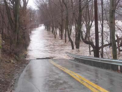
39 12-24 Hours Bee Flood Warning
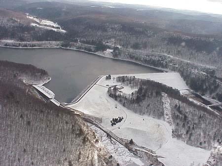
40 12-24 Hours Bee Flood Warning

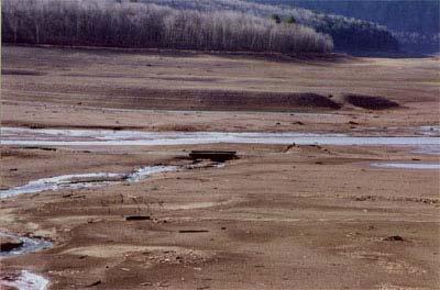
41 The importance of Flood Warnings in Flood Loss Reductions Flood Warning is a necessary piece of flood loss reduction EMA and occupants must have lead time Effective flood warnings provides lead time Flood Warnings are not a substitute reducing flood losses: Flood proofing Flood plain property acquisition Flood plain regulations Structural measures
42 The importance of Flood Warnings in Flood Loss Reductions NWS estimates flood warning can reduce economic flood damage by up to 10 percent Approximately half of flood related deaths occur in automobiles Road closure lead times are provided by flood warnings B/C ratio the flood warning system in the neighboring Susquehanna River basin is 12:1 (NWS, 1985)


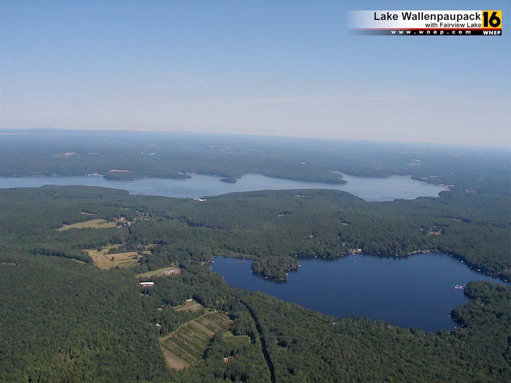
43 Web Access to Forecasts and Warnings Multiple Points of Entry

44 AHPS Matamoras/ Port Jervis

45 AHPS Hawley
46 Reservoir Impacts Delaware River Basin Model Simulations April 2-4, 2005 Flood
47 Cannonsville Reservoir Dec 20, %


48 Pepacton Reservoir Dec 20, %

49 Neversink Reservoir
50 Wallenpaupack Reservoir
51 Model Simulation Asked to provide a rough estimate the reduction in flood crests due to the existence of the following four reservoirs. Cannonsville.we model inflow and outflow Pepacton.we model inflow and outlfow Neversink.not explicitly modeled Wallenpaupack/Rio.not explicitly modeled
52 Model Simulation Limitations Modeling system not specifically designed post-event scenario simulations Modeling system not specifically designed to quantify impacts of reservoir operations downstream Do not have resources to do detailed engineering analysis of all factors
53 Model Simulation Results Our Modeling System gives a ballpark, or order of magnitude estimate only. Any further application of these results should only be done after confirmation with a comprehensive hydrologic study.
54 Model Simulation Results For this event, our simulations indicate that even though these dams spilled, crest levels would probably have been higher if the four dams did not exist. Lower Delaware 0.5 to 1.5 foot higher crests without dams * Upper Delaware 1.0 to 2.5 foot higher crests without dams* * Rough estimates only
55 Spilling Reservoir Impact Reservoir temporarily stores water Outflow (Spill) is spread over longer time period than inflow Peak crest downstream is lowered RESERVOIR INFLOW OUTFLOW
56 Summary/Conclusion At least 19 Major Floods in the past 166 years. Due to above average rainfall and the March precursor heavy rain event/flood event, soils were very wet and stream flows high prior to this Flood. Snowmelt also helped maintain high streamflows at the start of this event.
57 Summary/Conclusion Widespread heavy rainfall on April 2-3, combined with above conditions, caused this major flood event of rare intensity. National Weather Service ecasts and warnings provided very good inmation on the timing and magnitude of the flood threat. The four major reservoirs likely reduced the magnitude of flood crests downstream during this event.

58 THE END
Delaware River Flood Advisory Committee
 Delaware River Flood Advisory Committee A Partnership to Support Flood Mitigation Alan Tamm Pennsylvania Emergency Management Agency Bureau of Recovery and Mitigation atamm@state.pa.us Peter Gabrielsen
NOAA, National Weather Service Middle Atlantic River Forecast Center Briefing. 11:30am June 7, 2013
 NOAA, National Weather Service Middle Atlantic River Forecast Center Briefing 11:30am June 7, 2013 Key Messages Official river forecasts are calling for moderate flooding at 1 pt in NJ and minor flooding
IWT Scenario 1 Integrated Warning Team Workshop National Weather Service Albany, NY October 31, 2014
 Integrated Warning Team Workshop National Weather Service Albany, NY October 31, 2014 23 24 25 26 27 Scenario 1 Timeline November 23-27 Sun Mon Tue Wed Thu Thanksgiving Day Sunday, Nov. 23 @ 430 pm NWS
Winter Storm Saturday into Sunday December 14-15, 2013
 Winter Storm Saturday into Sunday December 14-15, 2013 Prepared 900 AM EST Friday December 13, 2013 Al Cope NOAA s NJ Forecast office http://www.erh.noaa.gov/phi/ Purpose of Briefing Briefing #3 for event.
Nor easter Monday Night Wednesday December 8 10, 2014
 Nor easter Monday Night Wednesday December 8 10, 2014 Prepared 400 PM EST Monday, December 8, 2014 Mitchell Gaines NOAA s Philadelphia/Mount Holly NJ Forecast Office www.weather.gov/phi/ Purpose of Briefing
Weather Briefing. Coastal Storm Monday-Wednesday Dec 8-10, National Weather Service. Prepared 12/8/14 6:30 AM
 Weather Briefing Coastal Storm Monday-Wednesday Dec 8-10, 2014 National Weather Service http://www.weather.gov/nyc Prepared 12/8/14 6:30 AM Overview of Potential Hazards A strong low pressure system will
Coastal Storm this Weekend
 Weather Briefing Prepared 9 AM EST Feb 5, 2010 Joe Miketta Warning Coordination Meteorologist NOAA s National Weather Service Philadelphia/Mt. Holly NJ Forecast Office 609-261 261-6602 6602 x223 Joseph.Miketta@noaa.gov
CW3E Atmospheric River Update Outlook Strong AR forecast to impact California this weekend - A strong AR with IVT as high as 1000 kg m -1 s -1 is
 CW3E Atmospheric River Update Outlook Strong AR forecast to impact California this weekend - A strong AR with IVT as high as 1000 kg m -1 s -1 is forecast make landfall over the West Coast this Weekend
Weather Briefing for Pennsylvania Feb Outlook Prepared 02/11/14 2 pm EST
 Weather Briefing for Pennsylvania Feb. 12-13 Outlook Prepared 02/11/14 2 pm EST Prepared by: National Weather Service State College, PA (Peter.Jung@noaa.gov) Pennsylvania Weather Overview A significant
NOAA s National Weather Service Philadelphia/Mt. Holly NJ
 Next Briefing Package: Friday, October 2, 2015 no later than 300 PM Hazards and Impacts: Overview: A dangerous weather pattern still threatens our region. Threats include very heavy rainfall, inland river
IWT Scenario 2 Integrated Warning Team Workshop National Weather Service Albany, NY October 31, 2014
 IWT Scenario 2 Integrated Warning Team Workshop National Weather Service Albany, NY October 31, 2014 09 10 11 12 13 Scenario 2 Timeline December 9-13 Tue Wed Thu Fri Sat Tue, Dec. 9 @ 5 am 2014 2014 2014
NOAA s National Weather Service Philadelphia/Mt. Holly NJ
 Early Week Coastal Flooding and snow Hazards and Impacts: Coastal Flooding: With the persistent onshore flow, and a new moon today, coastal flooding is expected at high tide through Tuesday morning. Moderate
Oregon Water Conditions Report May 1, 2017
 Oregon Water Conditions Report May 1, 2017 Mountain snowpack in the higher elevations has continued to increase over the last two weeks. Statewide, most low and mid elevation snow has melted so the basin
National Situation Report As of 5:00 a.m. EDT Tuesday, April 4, 2017
 Overview National Situation Report As of 5:00 a.m. EDT Tuesday, April 4, 2017 Table Of Contents Current Operations Monitoring Recovery National Response Coordination Center: Not Activated National Watch
-Assessment of current water conditions. - Precipitation Forecast. - Recommendations for Drought Monitor
 April 27, 2010 -Assessment of current water conditions - Precipitation Forecast - Recommendations for Drought Monitor 7 Day Precipitation 19-25 April 2010 Month-to-Date Precipitation 1-25 April 2010
Operational Hydrologic Ensemble Forecasting. Rob Hartman Hydrologist in Charge NWS / California-Nevada River Forecast Center
 Operational Hydrologic Ensemble Forecasting Rob Hartman Hydrologist in Charge NWS / California-Nevada River Forecast Center Mission of NWS Hydrologic Services Program Provide river and flood forecasts
NOAA s National Weather Service Philadelphia/Mt. Holly NJ. Summary. Changes
 Summary A crippling and potentially historic east coast snow storm will lead to blizzard conditions and major coastal flooding for portions of the area this weekend. Changes Blizzard Warning has been expanded
Significant Coastal Storm Today through Thursday, 11/7-8. Weather Briefing
 Significant Coastal Storm Today through Thursday, 11/7-8 Weather Briefing Prepared 10:00 am EST Wednesday, November 7, 2012 Presented by Gary Conte, Warning Coordination Meteorologist NOAA s National Weather
NOAA s National Weather Service Philadelphia/Mt. Holly NJ
 Next Briefing Package: Thursday, October 1, 2015 no later than 300 PM Hazards and Impacts: Overview: A dangerous weather pattern is developing for our region. Threats include very heavy rainfall, inland
FLOOD REPORT FOR MANITOBA. June 28, A Gale wind warning is in effect for Lake Manitoba and Lake Winnipeg
 FLOOD REPORT FOR MANITOBA June 28, 2014 A Gale wind warning is in effect for Lake Manitoba and Lake Winnipeg Flood Warning*: Flood Watch*: High Water Advisory*: - Assiniboine River, from Shellmouth Dam
Current Water Conditions in Massachusetts January 11, 2008
 Current Water Conditions in Massachusetts January 11, 2008 December precipitation was above normal December streamflows were below normal and normal December ground-water levels were below normal and normal
NWS SERFC Hydrologic Vulnerability Assessment. Monday, March 9 th, 2015 NOAA, National Weather Service Southeast River Forecast Center
 NWS SERFC Hydrologic Vulnerability Assessment Monday, March 9 th, 2015 NOAA, National Weather Service Southeast River Forecast Center Current Weather Map Today s weather map shows a blossoming system in
Heavy Rainfall Event of June 2013
 Heavy Rainfall Event of 10-11 June 2013 By Richard H. Grumm National Weather Service State College, PA 1. Overview A 500 hpa short-wave moved over the eastern United States (Fig. 1) brought a surge of
Spring Water Supply and Weather Outlook How about that near Miracle March?
 Spring Water Supply and Weather Outlook How about that near Miracle March? tim.bardsley@noaa.gov NWS Reno 4.10.18 1 Out the Window March and early April have been Boom not Bust Key Points Up Front Wet
NOAA Spring Flood Outlook for Iowa
 NOAA Spring Flood Outlook for Iowa Safeguard Iowa Partnership March 10, 2015 1 Agenda Orientation Maps Current Conditions Weather Outlook Spring Flood Outlook 2 1 Orientation Maps 3 4 2 5 Current Conditions
Speakers: NWS Buffalo Dan Kelly and Sarah Jamison, NERFC Jeane Wallace. NWS Flood Services for the Black River Basin
 Speakers: NWS Buffalo Dan Kelly and Sarah Jamison, NERFC Jeane Wallace NWS Flood Services for the Black River Basin National Weather Service Who We Are The National Oceanic and Atmospheric Administration
Weather Briefing Mixed Winter Storm Event February 26-27, 2013
 Weather Briefing Mixed Winter Storm Event February 26-27, 2013 Prepared 1200 PM EST Tuesday, February 26th, 2013 Joe Miketta NOAA s NJ Forecast Office http://www.erh.noaa.gov/phi/ Purpose of Briefing Briefing
Tropical Storm Harvey: SE Texas Impacts
 Tropical Storm Harvey: SE Texas Impacts 10 AM CDT UPDATE Thursday, August 24, 2017 Prepared by: Dan Reilly, Brian Kyle PLEASE MUTE YOUR LINES AND DON T PUT ON HOLD! Situation Overview Tropical Storm Harvey
Overview of a Changing Climate in Rhode Island
 Overview of a Changing Climate in Rhode Island David Vallee, Hydrologist in Charge, National Weather Service Northeast River Forecast Center, NOAA Lenny Giuliano, Air Quality Specialist, Rhode Island Department
Significant Flooding Expected
 Significant Flooding Expected Decision Support Briefing #5 As of: 9:00 AM September 14, 2018 What Has Changed? Flash Flood Watch now in effect for part of area, will be expanded later today 9/14/2018 9:23
Rainfall-River Forecasting: Overview of NOAA s Role, Responsibilities, and Services
 Dr. Thomas Graziano Chief Hydrologic Services Division NWS Headquarters Steve Buan Service Coordination Hydrologist NWS North Central River Forecast Center Rainfall-River Forecasting: Overview of NOAA
WEATHER NOTIFICATION STATEMENT
 WEATHER NOTIFICATION STATEMENT NEW DATA SHOWS SNOWSTORM THREAT FOR JAN 13-14 LOOKS MUCH HEAVIER BIGGER COVERAGE northwest NC (ice) ALL OF VA (Except Hampton Roads) all of MD/ DEL eastern southern PA southern
Daily Operations Briefing Sunday, November 23, :30 a.m. EST
 Daily Operations Briefing Sunday, November 23, 2014 8:30 a.m. EST Significant Activity: Nov 22 23 Significant Events: Flooding potential Western New York Tropical Activity: Atlantic Tropical cyclone activity
A Prepared Marylander Creates a Resilient Maryland
 Maryland Emergency Management Agency Operations Directorate Hazardous Winter Weather Outlook Briefing March 5, 2013 0800 A Prepared Marylander Creates a Resilient Maryland A strong low pressure will track
Oregon Water Conditions Report April 17, 2017
 Oregon Water Conditions Report April 17, 2017 Mountain snowpack continues to maintain significant levels for mid-april. By late March, statewide snowpack had declined to 118 percent of normal after starting
Minor Winter Flooding Event in northwestern Pennsylvania January 2017
 1. Overview Minor Winter Flooding Event in northwestern Pennsylvania 12-13 January 2017 By Richard H. Grumm National Weather Service State College, PA A combination of snow melt, frozen ground, and areas
Active Winter Weather Pattern February 4th-9th
 Active Winter Weather Pattern February 4th-9th Prepared 1230 PM EST Tuesday, February 4, 2014 Gary Szatkowski NOAA s NJ Forecast office http://www.erh.noaa.gov/phi/ Purpose of Briefing Briefing #6 Promote
A Complex Weather System: Tuesday Afternoon into Thursday March 3 5, 2015
 A Complex Weather System: Tuesday Afternoon into Thursday March 3 5, 2015 Briefing #1, prepared 900 AM EST Tuesday, March 3, 2015 by Meteorologists at NWS - WFO Mount Holly, NJ To promote situational awareness
X An X inside this box indicates that no flooding occurred within this Hydrologic Service Area.
 NWS FORM E-5 U.S. DEPARTMENT OF COMMERCE HSA OFFICE: NOAA, NATIONAL WEATHER SERVICE MONTHLY REPORT OF RIVER AND FLOOD CONDITIONS DATE: TO: North Webster, IN REPORT FOR (MONTH &YEAR): January, 2003 February
Prolonged Coastal Storm October 9 th -12 th, 2013
 Prolonged Coastal Storm October 9 th -12 th, 2013 Prepared 400 PM EDT Tuesday, October 8th, 2013 Gary Szatkowski NOAA s NJ Forecast office http://www.erh.noaa.gov/phi/ Purpose of Briefing Briefing #1 for
Forecasting Challenges
 Forecasting Challenges 2017-18 Alex Tardy- NWS San Diego Alexander.Tardy@noaa.gov CW3E meetings April 2018 Atmospheric Rivers Climate Forecast System by NOAA 100-h fuel moisture all-time low for South
HURRICANE IRENE. CONFERENCE CALL BRIEFING SLIDES Saturday August 27, :30 AM
 HURRICANE IRENE CONFERENCE CALL BRIEFING SLIDES Saturday August 27, 2011 8:30 AM NHC TRACK AND CONE HURRICANE IRENE WATCHES/WARNINGS Hurricane Warning along south coast including all of Cape Cod and Islands
FEMA Hazards Loss Modeling Task Force (MOTF) Situation Report #14. Colorado Spring Flood Risk ***FINAL REPORT***
 Situation Report #14. Colorado Spring Flood Risk ***FINAL REPORT***") FEMA Hazards Loss Modeling Task Force (MOTF) Situation Report #14 Colorado Spring Flood Risk FEMA Modeling Task Force (MOTF) Denver Federal Center, Building 710A Denver, Colorado 80225 Email: FEMA-MOTF@fema.dhs.gov
FEMA Hazards Loss Modeling Task Force (MOTF) Situation Report #14 Colorado Spring Flood Risk FEMA Modeling Task Force (MOTF) Denver Federal Center, Building 710A Denver, Colorado 80225 Email: FEMA-MOTF@fema.dhs.gov
NIDIS Intermountain West Drought Early Warning System April 18, 2017
 1 of 11 4/18/2017 3:42 PM Precipitation NIDIS Intermountain West Drought Early Warning System April 18, 2017 The images above use daily precipitation statistics from NWS COOP, CoCoRaHS, and CoAgMet stations.
PRELIMINARY DRAFT FOR DISCUSSION PURPOSES
 Memorandum To: David Thompson From: John Haapala CC: Dan McDonald Bob Montgomery Date: February 24, 2003 File #: 1003551 Re: Lake Wenatchee Historic Water Levels, Operation Model, and Flood Operation This
Daily Operations Briefing. Saturday, March 3, :30 a.m. EST
 Daily Operations Briefing Saturday, March 3, 2018 8:30 a.m. EST Northeast Coastal Storm Situation A high-impact and long duration coastal storm is bringing area of heavy rain and snow, significant coastal
UNITED STATES AND SOUTH AMERICA WEATHER ROUNDUP Sunday, December 17, 2017
 T-storm Weather Summary Extreme heat was followed by heavy rain in some key areas of Argentina yesterday. T-storms affect much of the driest Argentina, southern Brazil, and Paraguay through 7 to 10 days,
WEDNESDAY 30 TH AUGUST, :57 p.m. Tropical Storm Irma forms in the Atlantic. Don t let your guard down, always #Be Ready.
 Chapter 1 - The Set Up In the days leading up to Irma a series of composed and sobering text messages, presented in truncated form below, from Department of Disaster Management warned us of the pending
CropCast Corn and Soybean Report Kenny Miller Friday, March 17, 2017
 Accumulated Rainfall (inches) Accumulated GDDs Temperature ( F)/Wind Speed (mph) Precipitation (inches) CropCast Corn and Soybean Report Kenny Miller Friday, March 17, 2017 Peoria, IL Regional Forecast
CropCast Corn and Soybean Report Kenny Miller Tuesday, March 14, 2017
 Accumulated Rainfall (inches) Accumulated GDDs Temperature ( F)/Wind Speed (mph) Precipitation (inches) CropCast Corn and Soybean Report Kenny Miller Tuesday, March 14, 2017 Peoria, IL Regional Forecast
TROPICAL STORM HARVEY BRIEFING
 TROPICAL STORM HARVEY BRIEFING 10:00 AM CDT Sunday, August 27, 2017 Prepared by: NWS LIX NWSNewOrleans www.weather.gov/neworleans Situation Overview New Information Tropical Storm Winds 40mph Immediate
 October 16 th, 2012 2010-12 La Niña event reached its biggest peak since the mid-70s in late 2010, followed by a brief excursion to ENSOneutral conditions during mid-2011; it reached a second peak last
Hurricane Sandy October 28 th 31 st 2012
 Hurricane Sandy October 28 th 31 st 2012 Prepared 530 PM EDT Saturday October 27, 2012 Gary Szatkowski NOAA s NJ Forecast Office Weather.gov/phi Purpose of Briefing Briefing #7 for event Promote situational
NIDIS Intermountain West Drought Early Warning System March 26, 2019
 NIDIS Intermountain West Drought Early Warning System March 26, 2019 The images above use daily precipitation statistics from NWS COOP, CoCoRaHS, and CoAgMet stations. From top to bottom, and left to right:
TROPICAL DEPRESSION HARVEY BRIEFING
 TROPICAL DEPRESSION HARVEY BRIEFING 10:15 PM CDT Wednesday, August 23, 2017 Prepared by: Lara Beal NWSCorpus www.weather.gov/corpuschristi Situation Overview No changes to Watches. Hurricane Watch remains
Missouri River Basin Water Management Monthly Update
 Missouri River Basin Water Management Monthly Update Participating Agencies 255 255 255 237 237 237 0 0 0 217 217 217 163 163 163 200 200 200 131 132 122 239 65 53 80 119 27 National Oceanic and Atmospheric
Souris River Basin Spring Runoff Outlook As of March 1, 2019
 Souris River Basin Spring Runoff Outlook As of March 1, 2019 Prepared by: Flow Forecasting & Operations Planning Water Security Agency Basin Conditions Summer rainfall in 2018 over the Saskatchewan portion
MARFC Sandy Briefing. NWS Middle Atlantic River Forecast Center 11am Monday Oct 29, 2012
 MARFC Sandy Briefing NWS Middle Atlantic River Forecast Center 11am Monday Oct 29, 2012 Key Message Continue to monitor http://water.weather.gov for frequent updates to river forecasts. storm is underway
TROPICAL STORM HARVEY COE Navigation Call - Update
 TROPICAL STORM HARVEY COE Navigation Call - Update 10:00 AM CDT Tuesday, August 29, 2017 Prepared by: NWS LIX NWSNewOrleans www.weather.gov/neworleans Situation Overview New Information Drifting ENE at
Coastal Storm. Wednesday through Friday, 3/6-8/2013 Weather Briefing
 Coastal Storm Wednesday through Friday, 3/6-8/2013 Weather Briefing Prepared 2:00 PM EST Wednesday, March 6, 2013 National Weather Service New York, NY Purpose of Briefing Promote Situational Awareness
Weather and Climate Summary and Forecast April 2018 Report
 Weather and Climate Summary and Forecast April 2018 Report Gregory V. Jones Linfield College April 4, 2018 Summary: A near Miracle March played out bringing cooler and wetter conditions to the majority
Operational Perspectives on Hydrologic Model Data Assimilation
 Operational Perspectives on Hydrologic Model Data Assimilation Rob Hartman Hydrologist in Charge NOAA / National Weather Service California-Nevada River Forecast Center Sacramento, CA USA Outline Operational
NOAA s National Weather Service Philadelphia/Mt. Holly NJ
 Snow and Coastal Flooding through this evening Hazards and Impacts: Coastal Flooding: With the persistent onshore flow, and a new moon yesterday, coastal flooding is expected at high tide today. Moderate
Tropical Update. 1 PM EDT Monday, May 21, 2018 Caribbean Disturbance (20%)
") Tropical Update 1 PM EDT Monday, May 21, 2018 Caribbean Disturbance (20%) This update is intended for government and emergency response officials, and is provided for informational and situational awareness
Tropical Update 1 PM EDT Monday, May 21, 2018 Caribbean Disturbance (20%) This update is intended for government and emergency response officials, and is provided for informational and situational awareness
Souris River Basin Spring Runoff Outlook As of March 15, 2018
 Souris River Basin Spring Runoff Outlook As of March 15, 2018 Prepared by: Flow Forecasting & Operations Planning Water Security Agency Basin Conditions Summer rainfall in 2017 in the Saskatchewan portion
NIDIS Intermountain West Regional Drought Early Warning System February 7, 2017
 NIDIS Drought and Water Assessment NIDIS Intermountain West Regional Drought Early Warning System February 7, 2017 Precipitation The images above use daily precipitation statistics from NWS COOP, CoCoRaHS,
The hydrologic service area (HSA) for this office covers Central Kentucky and South Central Indiana.
 for this office covers Central Kentucky and South Central Indiana.") January 2012 February 13, 2012 An X inside this box indicates that no flooding occurred within this hydrologic service area. January 2012 continued the string of wet months this winter. Rainfall was generally
January 2012 February 13, 2012 An X inside this box indicates that no flooding occurred within this hydrologic service area. January 2012 continued the string of wet months this winter. Rainfall was generally
Flood Risk Assessment
 Flood Risk Assessment February 14, 2008 Larry Schick Army Corps of Engineers Seattle District Meteorologist General Assessment As promised, La Nina caused an active winter with above to much above normal
Weather briefing Strong Coastal Nor easter November 7 th -8 th, 2012
 Weather briefing Strong Coastal Nor easter November 7 th -8 th, 2012 Prepared 1245 PM EDT Tuesday November 6, 2012 Gary Szatkowski NOAA s NJ Forecast Office Weather.gov/phi Purpose of Briefing Briefing
An Overview of Operations at the West Gulf River Forecast Center Gregory Waller Service Coordination Hydrologist NWS - West Gulf River Forecast Center
 National Weather Service West Gulf River Forecast Center An Overview of Operations at the West Gulf River Forecast Center Gregory Waller Service Coordination Hydrologist NWS - West Gulf River Forecast
Hydrologic Conditions in the Delaware River Basin
 2017 Hydrologic Conditions in the Delaware River Basin Prepared by Operations Staff June 2018 Hydrologic Highlights Hydrologic Conditions in the Delaware River Basin Annual Report 2017 At the start of
Hydrologic Forecast Centre. Manitoba Infrastructure. Winnipeg, Manitoba FEBRUARY FLOOD OUTLOOK REPORT FOR MANITOBA.
 Page 1 of 20 Hydrologic Forecast Centre Manitoba Infrastructure Winnipeg, Manitoba FEBRUARY FLOOD OUTLOOK REPORT FOR MANITOBA February 28, 2019 Overview The February Outlook Report prepared by the Hydrologic
California OES Atmospheric River Events Weather Threat Briefing
 California OES Atmospheric River Events Weather Threat Briefing 23 February 2017 10:00 AM PST Day 1: Flooding continues along small streams and creeks and some main stem rivers. National Weather Service
January 25, Summary
 January 25, 2013 Summary Precipitation since the December 17, 2012, Drought Update has been slightly below average in parts of central and northern Illinois and above average in southern Illinois. Soil
Mid-West Heavy rains 18 April 2013
 Abstract: Mid-West Heavy rains 18 April 2013 By Richard H. Grumm and Charles Ross National Weather Service State College, PA The relatively wet conditions during the first 16 days of April 2013 set the
Folsom Dam Water Control Manual Update
 Folsom Dam Water Control Manual Update Public Workshop April 3, 2014 Location: Sterling Hotel Ballroom 1300 H Street, Sacramento US Army Corps of Engineers BUILDING STRONG WELCOME & INTRODUCTIONS 2 BUILDING
Heavy Rain and Potential for Dangerous Flooding for northeast SC and southeast NC
 US National Weather Service Wilmington NC @NWSWilmingtonNC http://weather.gov/ilm ***Life Threatening Flooding Possible*** Heavy Rain and Potential for Dangerous Flooding for northeast SC and southeast
Hydrologic Briefing Tropical Storm Harvey
 Hydrologic Briefing Tropical Storm Harvey 10:30 AM CDT Sunday, August 27, 2017 Prepared by: John Metz NWSCorpus www.weather.gov/corpuschristi Situation Overview Tropical Storm Harvey Harvey to remain a
NIDIS Intermountain West Drought Early Warning System January 15, 2019
 NIDIS Drought and Water Assessment NIDIS Intermountain West Drought Early Warning System January 15, 2019 Precipitation The images above use daily precipitation statistics from NWS COOP, CoCoRaHS, and
Northeast River Forecast Center s
 Northeast River Forecast Center s Apr 13 th Spring Outlook Brought to you by: Edward Capone Service Coordination Hydrologist Overview to Include: Potential flood outlook convective/synoptic conditions
The Documentation of Extreme Hydrometeorlogical Events: Two Case Studies in Utah, Water Year 2005
 The Documentation of Extreme Hydrometeorlogical Events: Two Case Studies in Utah, Water Year 2005 Tim Bardsley1*, Mark Losleben2, Randy Julander1 1. USDA, NRCS, Snow Survey Program, Salt Lake City, Utah.
California OES Weather Threat Briefing
 California OES Weather Threat Briefing Wednesday, January 16, 2019 9:00 AM PST Day 1: Strong winds, heavy mountain snow and heavy rain with isolated thunderstorms across much of the state through Thursday
Update on Seasonal Conditions & Summer Weather Outlook
 Update on Seasonal Conditions & Summer Weather Outlook Andy Bryant National Weather Service Portland, Oregon June 6, 2018 Overview Quick review of winter and spring conditions Seasonal water supply forecasts
Tropical Update. 5 AM EDT Thursday, September 7, 2017 Hurricane Irma, Hurricane Jose, and Hurricane Katia
 Tropical Update 5 AM EDT Thursday, September 7, 2017 Hurricane Irma, Hurricane Jose, and Hurricane Katia This update is intended for government and emergency response officials, and is provided for informational
Winter Storm Tomorrow-Tomorrow Night
 Winter Storm Tomorrow-Tomorrow Night Decision Support Briefing #1 As of 4:30 PM Tuesday, February 19, 2019 What Has Changed? Initial Briefing Main Points Hazard Impacts Location Timing Snow Snow will create
NWS FORM E-5 U.S. DEPARTMENT OF COMMERCE I HYDRO SERVICE AREA NOAA, NATIONAL WEATHER SERVICE I Indianapolis, IN MONTHLY REPORT
 NWS FORM E-5 U.S. DEPARTMENT OF COMMERCE I HYDRO SERVICE AREA NOAA, NATIONAL WEATHER SERVICE I Indianapolis, IN. 1-------------------- MONTHLY REPORT OF RIVER AND FLOOD CONDITIONSI REPORT FOR I November
Hurricane Harvey: SE Texas Impacts. 10 AM CDT UPDATE Saturday, August 26, 2017 Prepared by: Dan Reilly, Brian Kyle
 Hurricane Harvey: SE Texas Impacts 10 AM CDT UPDATE Saturday, August 26, 2017 Prepared by: Dan Reilly, Brian Kyle Latest Observations and Radar Hurricane Harvey centered near Victoria and weakening Wind
Upper Missouri River Basin December 2017 Calendar Year Runoff Forecast December 5, 2017
 Upper Missouri River Basin December 2017 Calendar Year Runoff Forecast December 5, 2017 Calendar Year Runoff Forecast Explanation and Purpose of Forecast U.S. Army Corps of Engineers, Northwestern Division
Tropical Update. 5 AM EDT Tuesday, September 12, 2017 Post-Tropical Cyclone Irma, Hurricane Jose, & Tropical Wave (10%)
") Tropical Update 5 AM EDT Tuesday, September 12, 2017 Post-Tropical Cyclone Irma, Hurricane Jose, & Tropical Wave (10%) This update is intended for government and emergency response officials, and is provided
Tropical Update 5 AM EDT Tuesday, September 12, 2017 Post-Tropical Cyclone Irma, Hurricane Jose, & Tropical Wave (10%) This update is intended for government and emergency response officials, and is provided
Hydrologic Conditions in the Delaware River Basin
 Hydrologic Conditions in the Delaware River Basin April : Flooding in Lambertville, New Jersey Aerial photo used with permission of www.elevated-images.com Annual Report Prepared by Operations Staff June
Tropical Update. 11 AM EDT Wednesday, October 10, 2018 Hurricane Michael, Hurricane Leslie & Tropical Storm Nadine, Caribbean Low (40%)
") Tropical Update 11 AM EDT Wednesday, October 10, 2018 Hurricane Michael, Hurricane Leslie & Tropical Storm Nadine, Caribbean Low (40%) This update is intended for government and emergency response officials,
Tropical Update 11 AM EDT Wednesday, October 10, 2018 Hurricane Michael, Hurricane Leslie & Tropical Storm Nadine, Caribbean Low (40%) This update is intended for government and emergency response officials,
TROPICAL STORM HARVEY BRIEFING
 TROPICAL STORM HARVEY BRIEFING 2:00 PM CDT Tuesday, August 29, 2017 Prepared by: NWS LIX NWSNewOrleans www.weather.gov/neworleans Situation Overview New Information Moving NNE Max sustained wind 45 mph
Hurricane Matthew Life Threatening Flash Flooding Likely
 Hurricane Matthew Life Threatening Flash Flooding Likely Threat Assessment for northeast South Carolina & southeast North Carolina National Weather Service Wilmington NC 12 AM EDT Saturday October 8, 2016
Hurricane Harvey: SE Texas Impacts. 10 PM CDT UPDATE Friday, August 25, 2017 Prepared by: Lance Wood
 Hurricane Harvey: SE Texas Impacts 10 PM CDT UPDATE Friday, August 25, 2017 Prepared by: Lance Wood Latest Observations Hurricane Harvey making landfall this evening near Rockport as a category 4 hurricane.
MONTHLY REPORT OF RIVER AND FLOOD CONDITIONS
 NWS FORM E-5 U.S. DEPARTMENT OF COMMERCE HSA OFFICE: NOAA, NATIONAL WEATHER SERVICE NWS Northern Indiana (IWX) REPORT FOR (MONTH&YEAR): January 2005 MONTHLY REPORT OF RIVER AND FLOOD CONDITIONS DATE: February
Daily Operations Briefing Saturday, October 1, :30 a.m. EDT
 Daily Operations Briefing Saturday, October 1, 2016 8:30 a.m. EDT Significant Activity Sept 30-Oct 1 Significant Events: None Tropical Activity: Atlantic Hurricane Matthew (CAT4); Disturbance 1 Low (10%)
Tropical Update. 11 AM EDT Tuesday, October 9, 2018 Hurricane Michael, Tropical Storm Leslie, Tropical Storm Nadine
 Tropical Update 11 AM EDT Tuesday, October 9, 2018 Hurricane Michael, Tropical Storm Leslie, Tropical Storm Nadine This update is intended for government and emergency response officials, and is provided
Daily Operations Briefing. Sunday, March 4, :30 a.m. EST
 Daily Operations Briefing Sunday, March 4, 2018 8:30 a.m. EST Significant Activity Mar 3-4 Significant Events: Northeast coastal storm Tropical Activity: Western Pacific No activity affecting U.S. interests
The Spring Storm of April 2007 By Richard H. Grumm National Weather Service Office State College PA 16803
 The Spring Storm of 13-16 April 2007 By Richard H. Grumm National Weather Service Office State College PA 16803 1. INTRODUCTION A major spring storm struck the eastern United States from 13 through 16
The hydrologic service area (HSA) for this office covers Central Kentucky and South Central Indiana.
 for this office covers Central Kentucky and South Central Indiana.") MONTH YEAR January 2011 February 15, 2011 X An X inside this box indicates that no flooding occurred within this hydrologic service area. January 2011 was drier than normal in all locations in the area.
MONTH YEAR January 2011 February 15, 2011 X An X inside this box indicates that no flooding occurred within this hydrologic service area. January 2011 was drier than normal in all locations in the area.