Nov. 21, D.I. Lee, C.H. You, M. Jang, D.S. Kim, S.M. Jang, J.H. Jeong
|
|
|
- Andrew Walters
- 5 years ago
- Views:
Transcription

1 9 th Weather Radar Workshop The field observations at the southern area of Korea Nov. 21, 2008 D.I. Lee, C.H. You, M. Jang, D.S. Kim, S.M. Jang, J.H. Jeong Department of Environmental Atmospheric Sciences, Pukyong National University, Busan, Korea Global Research Laboratory
2 Outline 1. Introduction ti of Field Observations 2006 to Preliminary Results using data in 2007 Synoptic conditions Wind fields from Dual Doppler Radar Analysis Wind shear from Radio sonde and DDRA Drop Size Distributions 3. Summary


3 Experiment design Jeju Island IEODO Typhoon


4 Jejudo and Marado in 2006 S-band Doppler radars(kma) Rain gauge ( type: 0.1 mm, 0.5 mm) Radio sonde POSS AWS Filter paper


 Rain")


5 Okinawa, JAPAN in X-band Doppler Radar ( Red, Blue ) Rain gauge (type : 0.1 mm) Joss-Waldvogel Disdrometer (J. W. Disdrometer) AWS Radio sonde Filter paper


6 Ieodo in 2007 and 2008 S-band Doppler Radars(KMA) Rain gauge (type: 0.1 mm, 0.5 mm) Radio sonde Filter paper LPC Rain sampling


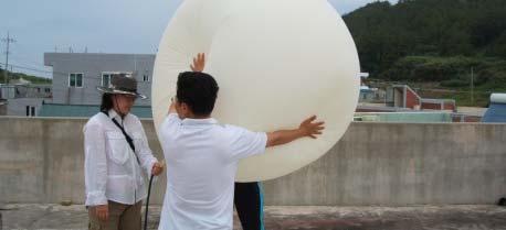


7 Chujado in 2007 S-band Doppler radars(kma) Rain gauge (type: 0.1 mm, 0.5 mm) Radio sonde POSS disdrometer and filter papers AWS Filter paper LPC
 JWD(J1)")

 NCU (Taiwan) NCU (Taiwan) CWB")

 Gau-Lan POSS(P2) PKNU")
 ada) Ho-Juan POSS(P5) EC3")
 CCU2 (Taiwan) Lin-Luo")
 CCU4 (Taiwan) Ma-Jia.")
 NCU2 (Taiwan) Quan-Fu")
8 Taiwan in 2008 From Prof. GyuWon Lee VertiX MRR(M5) JWD(J1) POSS(P3) 2DVD ISS INSTRUMENT Tipping bucket raingauge ORGANIZATION KNU (Korea) KNU (Korea) NCU1 (Taiwan) EC1 (Canada) NCU (Taiwan) NCU (Taiwan) CWB (Taiwan) STATION SuperSite : Quan-Xin Elementary School Traditional raingaugege NTU (Taiwan) an) POSS(P1) McGill (Canada) Gau-Lan POSS(P2) PKNU (Korea) Te-Wen M4 POSS(P4) EC2 (Canada) ada) Ho-Juan POSS(P5) EC3 (Canada) Si-Wei MRR(M1) CCU1 (Taiwan) Tu-Ku MRR(M2) CCU2 (Taiwan) Lin-Luo NCAR S-POL JDOP MRR(M3) CCU3 (Taiwan) Shi-Long MRR(M4) CCU4 (Taiwan) Ma-Jia. V. O. JWD(J2) CCU (Taiwan) Ma-Jia J. H. S JWD(J3) NCU2 (Taiwan) Quan-Fu JWD(J4) NCU3 (Taiwan) Fan-Hua JWD(J5) NCU4 (Taiwan) Chin-San
9 36 Preliminary results Gwangju At Chujado 35 : From June 21 to July 10, Heuksando Sonde Radar Jindo Gosan Chujado Seongsan Location of observation site Observation Instruments : S band radars, POSS, Raingauges, Radiosonde, Filter papers, p LPC, Rain sampling -Synoptic condition : Surface weather chart, NCEP/NCAR reanalysis - Dual Doppler analysis : Gosan and Seongsan S-band radar - Drop Size Distributions : POSS - Satellite images, raingauge data, sounding data
10 Case study : Chang-ma front accompanied by strong low pressure(05 July 2007 ~ 06 July 2007) Accumulated rainfall amount for date Rainfall amo ount(mm) Date 138.4mm


")


11 Case study : Chang-ma front accompanied by strong low pressure(05 July 2007 ~ 06 July 2007) 09 KST 06 July (mm/hr) Rainrate :00 20:00 0:00 4:00 8:00 12:00 16:00 July 05 Time July 06
12 NCEP/NCAR reanalysis data [03 KST 06 July 2007] (a) Surface (b) 850 hpa WS & P WS & θ E (c) 500 hpa (d) 300 hpa WS &RV WS & hgt
13 Vertical Profile of Reflectivity at Chujado Case 1 Case 2 Case 3 July 05 July 06


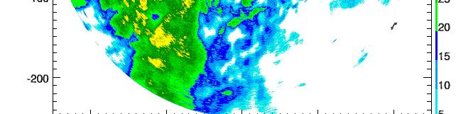

14 Radar Images with Case Case 1 Case 2 Case 3


15 Dual Doppler analysis CASE Ⅰ July 05 July 06 Chujado POSS


16 Dual Doppler analysis CASE Ⅱ July 05 July 06


17 Dual Doppler analysis CASE Ⅲ July 05 July 06
18 Vertical wind shear analysis by sonde observation :00 KST TVWS 10 8 m/s/100m Total Vertical Wind Shear(TVWS) Directional Vertical Wind Shear(DVWS) (km) Height( WS WD θ θe θs RH DVWS 10 Degree/100m 8 Height(km m) RH(%)
19 Vertical wind shear analysis by sonde observation :00 KST TVWS 10 8 m/s/100m sure (hpa) Pres (km) Height( WS WD θ θe θs RH Speed of vertical motion of sonde (m/s) DVWS 10 Degree/100m 8 Height(km m) RH(%)
20 Case 1 Case 2 Case 3 10 July 05 July 06 TVWS 8 He eight(km) :30 21:40 01:00 Time 04:20 07:40 11:00 14:30 m/s/500m
21 Case 1 Case 2 Case 3 10 July 05 July 06 DVWS 8 He eight(km) :30 21:40 01:00 T04:20 i m e 07:40 11:00 14:30 Degree/500m
22 Raindrop size distributions Case 1 18:00 19:40 21:20 23:00 00:40 July 05 July 06
23 Raindrop size distributions Case 2 01:00 01:50 02:40 03:30 04:20 05:00 July 06 July 06
24 Raindrop size distributions Case 3 05:00 06:40 08:20 10:00 11:40 13:20 July 06 July 06
25 Raindrop size distributions DSD on the ground during the passage of the precipitation systems μ N( D) = N 0D exp( ΛD) CASE Ⅰ CASE Ⅱ CASE Ⅲ R(mm/hr) μ Λ N Sample NO
26 Summary 10 km 10 m/s The inside of Changma front 30dBz >> 30dBz << 8 km 6 km 6 km 6 km 4 km 4 km 2 km DSD Rain rate (mm/hr) Number concentration Total precipitation by raingauge Case 1 Case 2 Case High : at the range of larger than 2mm in diameter Low : at the all range High : at the range of smaller than 2mm in diameter 55.4mm 11.7mm 71.3mm
Characteristics of Precipitation System Accompanied with Changma Front at Chujado, Korea, in 5 to 6 July 2007
 Manuscript prepared for J. Name with version 2.3 of the L A TEX class copernicus.cls. Date: 18 May 2009 Characteristics of Precipitation System Accompanied with Changma Front at Chujado, Korea, in 5 to
THE CHARACTERISTICS OF DROP SIZE DISTRIBUTIONS AND CLASSIFICATIONS OF CLOUD TYPES USING GUDUCK WEATHER RADAR, BUSAN, KOREA
 THE CHARACTERISTICS OF DROP SIZE DISTRIBUTIONS AND CLASSIFICATIONS OF CLOUD TYPES USING GUDUCK WEATHER RADAR, BUSAN, KOREA Dong-In Lee 1, Min Jang 1, Cheol-Hwan You 2, Byung-Sun Kim 2, Jae-Chul Nam 3 Dept.
The Rainfall System Classification over the Korean Peninsula Using TRMM TMI and Ground Measurement Data
 6 th International Precipitation Working Group Workshop-São José dos Campos- October 15~19, 2012 The Rainfall System Classification over the Korean Peninsula Using TRMM TMI and Ground Measurement Data
BY REAL-TIME ClassZR. Jeong-Hee Kim 1, Dong-In Lee* 2, Min Jang 2, Kil-Jong Seo 2, Geun-Ok Lee 2 and Kyung-Eak Kim 3 1.
 P2.6 IMPROVEMENT OF ACCURACY OF RADAR RAINFALL RATE BY REAL-TIME ClassZR Jeong-Hee Kim 1, Dong-In Lee* 2, Min Jang 2, Kil-Jong Seo 2, Geun-Ok Lee 2 and Kyung-Eak Kim 3 1 Korea Meteorological Administration,
Vertical structure and precipitation properties in typhoon rainbands
 The 4 th THORPEX-Asia Science workshop, Kunming, China on 31 Oct.-2 Nov. 2012 Vertical structure and precipitation properties in typhoon rainbands Dong-Kyun Kim, Yeon-Hee Kim, Kwan-Young Chung Forecast
Taiwan s South China Sea-Maritime Continent (SCS-MC) Field Campaign ( )
 Field Campaign ( )") Taiwan s South China Sea-Maritime Continent (SCS-MC) Field Campaign (2017-2019) Lead scientists: Po-Hsiung Lin (NTU), Yu-Chieng Liou (NCU/TTFRI) The Maritime Continent (MC) and South China Sea (SCS) acts
Taiwan s South China Sea-Maritime Continent (SCS-MC) Field Campaign (2017-2019) Lead scientists: Po-Hsiung Lin (NTU), Yu-Chieng Liou (NCU/TTFRI) The Maritime Continent (MC) and South China Sea (SCS) acts
L. McMurdie, R. Houze, J. Zagrodnik, W. Petersen, M. Schwaller
 L. McMurdie, R. Houze, J. Zagrodnik, W. Petersen, M. Schwaller International Atmospheric Rivers Conference, San Diego, CA, 9 August 2016 Goals of OLYMPEX Validate GPM satellite radar and passive microwave
Validation experiments of GPM/DPR on the pure oceanic precipitating clouds by instruments on board R/V Mirai
 Validation experiments of GPM/DPR on the pure oceanic precipitating clouds by instruments on board R/V Mirai PI: Masaki KATSUMATA (JAMSTEC) CI: Katsuhiro NAKAGAWA (NICT) Jun INOUE (NIPR / JAMSTEC) Takashi
 Identification of Predictors for Nowcasting Heavy Rainfall In Taiwan --------------------- Part II: Storm Characteristics and Nowcasting Applications Challenges in Developing Nowcasting Applications for
An empirical method to improve rainfall estimation of dual polarization radar using ground measurements
 An empirical method to improve rainfall estimation of dual polarization radar using ground measurements 5 Jungsoo Yoon 1, Mi-Kyung Suk 1, Kyung-Yeub Nam 1, Jeong-Seok Ko 1, Hae-Lim Kim 1, Jong-Sook Park
Analysis of Radar Rainfall Estimation Accuracy using Hybrid Surface Rainfall (HSR) Technique
 Technique") Analysis of Radar Rainfall Estimation Accuracy using Hybrid Surface Rainfall (HSR) Technique Hye-Sook Park 1, Min-Ho Lee 1, Mi-Kyung Suk 1, Jae-Won Lee 1 1 Korea Meteorological Administration, Weather
Analysis of Radar Rainfall Estimation Accuracy using Hybrid Surface Rainfall (HSR) Technique Hye-Sook Park 1, Min-Ho Lee 1, Mi-Kyung Suk 1, Jae-Won Lee 1 1 Korea Meteorological Administration, Weather
The Impacts of GPSRO Data Assimilation and Four Ices Microphysics Scheme on Simulation of heavy rainfall Events over Taiwan during June 2012
 The Impacts of GPSRO Data Assimilation and Four Ices Microphysics Scheme on Simulation of heavy rainfall Events over Taiwan during 10-12 June 2012 Pay-Liam LIN, Y.-J. Chen, B.-Y. Lu, C.-K. WANG, C.-S.
Rainfall estimation for the first operational S-band polarimetric radar in Korea
 Rainfall estimation for the first operational S-band polarimetric radar in Korea Cheol-Hwan You 1, Dong-In Lee 2, Mi-Young Kang 2 and Young-Su Bang 2 1 Atmospheric Environmental Research Institute, Pukyong
The Development of Guidance for Forecast of. Maximum Precipitation Amount
 The Development of Guidance for Forecast of Maximum Precipitation Amount Satoshi Ebihara Numerical Prediction Division, JMA 1. Introduction Since 198, the Japan Meteorological Agency (JMA) has developed
Preliminary result of hail detection using an operational S-band polarimetric radar in Korea
 Preliminary result of hail detection using an operational S-band polarimetric radar in Korea Mi-Young Kang 1, Dong-In Lee 1,2, Cheol-Hwan You 2, and Sol-Ip Heo 3 1 Department of Environmental Atmospheric
A FIELD STUDY TO CHARACTERISE THE MEASUREMENT OF PRECIPITATION USING DIFFERENT TYPES OF SENSOR. Judith Agnew 1 and Mike Brettle 2
 A FIELD STUDY TO CHARACTERISE THE MEASUREMENT OF PRECIPITATION USING DIFFERENT TYPES OF SENSOR Judith Agnew 1 and Mike Brettle 2 1 STFC Rutherford Appleton Laboratory, Harwell Oxford, Didcot, Oxfordshire,
QUANTITATIVE PRECIPITATION ESTIMATION AND ERROR ANALYSIS WITH A UHF WIND PROFILING RADAR AND A TWO-DIMENSIONAL VIDEO DISDROMETER
 P13B.6 1 QUANTITATIVE PRECIPITATION ESTIMATION AND ERROR ANALYSIS WITH A UHF WIND PROFILING RADAR AND A TWO-DIMENSIONAL VIDEO DISDROMETER Laura M. Kanofsky 1,, Phillip B. Chilson 1, Terry J. Schuur 2,
Characteristics of 2014 summer climate over South Korea
 2 nd East Asia winter Climate Outlook Forum Characteristics of 2014 summer climate over South Korea October 30, 2014 So-Young Yim, E-hyung Park, and Hyun-Sook Jung Climate Prediction Division Korea Meteorological
Rainfall estimation in mountainous regions using X-band polarimetric weather radar
 Rainfall estimation in mountainous regions using X-band polarimetric weather radar Shakti P.C. 1,2, M. Maki 1,2, S. Shimizu 2, T. Maesaka 2, D.-S. Kim 2, D.-I. Lee 3 and H. Iida 4 1 Graduate School of
DANO, Burkina Faso. Instruments Data set Status Highlights. Norbert Kalthoff and Juliane Schwendike. Institut für Meteorologie und Klimaforschung
 DANO, Burkina Faso Instruments Data set Status Highlights by Norbert Kalthoff and Juliane Schwendike Dano (super-)site in Burkina Faso Dreyer Foundation Dano Dano Bontioli Measurements at Bontioli site
Environment and morphology of mesoscale convective systems associated with the Changma front during 9 10 July 2007
 doi:10.5194/angeo-30-1235-2012 Author(s) 2012. CC Attribution 3.0 License. Annales Geophysicae Environment and morphology of mesoscale convective systems associated with the Changma front during 9 10 July
COSMIC GPS Radio Occultation and
 An Impact Study of FORMOSAT-3/ COSMIC GPS Radio Occultation and Dropsonde Data on WRF Simulations 27 Mei-yu season Fang-Ching g Chien Department of Earth Sciences Chien National and Taiwan Kuo (29), Normal
Validation of MÉRA total precipitation at Stornoway (Scotland) with a 24 GHz micro rain radar: A Preliminary Investigation
 with a 24 GHz micro rain radar: A Preliminary Investigation") Validation of MÉRA total precipitation at Stornoway (Scotland) with a 24 GHz micro rain radar: A Preliminary Investigation Dr. Edward Graham 1 and Dr. Chris Kidd 2 1 University of the Highlands and Islands,
Validation of MÉRA total precipitation at Stornoway (Scotland) with a 24 GHz micro rain radar: A Preliminary Investigation Dr. Edward Graham 1 and Dr. Chris Kidd 2 1 University of the Highlands and Islands,
Quantitative Estimation of the Precipitation utilizing the Image Signal of Weather Radar
 Journal of Multimedia Information System VOL. 5, NO. 4, December 2018 (pp. 245-256): ISSN 2383-7632(Online) http://dx.doi.org/10.9717/jmis.2018.5.4.245 Quantitative Estimation of the Precipitation utilizing
ABSTRACT 3 RADIAL VELOCITY ASSIMILATION IN BJRUC 3.1 ASSIMILATION STRATEGY OF RADIAL
 REAL-TIME RADAR RADIAL VELOCITY ASSIMILATION EXPERIMENTS IN A PRE-OPERATIONAL FRAMEWORK IN NORTH CHINA Min Chen 1 Ming-xuan Chen 1 Shui-yong Fan 1 Hong-li Wang 2 Jenny Sun 2 1 Institute of Urban Meteorology,
Experimental Test of the Effects of Z R Law Variations on Comparison of WSR-88D Rainfall Amounts with Surface Rain Gauge and Disdrometer Data
 JUNE 2001 NOTES AND CORRESPONDENCE 369 Experimental Test of the Effects of Z R Law Variations on Comparison of WSR-88D Rainfall Amounts with Surface Rain Gauge and Disdrometer Data CARLTON W. ULBRICH Department
Impact of FORMOSAT 3/COSMIC Radio Occultation. near Taiwan
 Impact of FORMOSAT 3/COSMIC Radio Occultation Data on Predictions i of Typhoon and Mei yu Fronts near Taiwan CHING YUANG HUANG 1,2, CHAN SENG WONG 1, CHIEN JU WANG 2, and CHIN CHENG TSAI 2 1 Department
Rainfall estimation by S-band polarimetric radar in Korea. Part I: preprocessing and preliminary results
 METEOROLOGICAL APPLICATIONS Meteorol. Appl. 21: 975 983 (2014) Published online 2 June 2014 in Wiley Online Library (wileyonlinelibrary.com) DOI: 10.1002/met.1454 Rainfall estimation by S-band polarimetric
N P Amrutha Kumari, S Balaji Kumar, J Jayalakshmi & K Krishna Reddy $,*
 Indian Journal of Radio & Space Physics Vol 43, February 2014, pp 57-66 Raindrop size distribution variations in JAL and NILAM cyclones induced precipitation observed over Kadapa (14.47 o N, 78.82 o E),
Ki-Hong Min 1*, Seonhee Choo 2, and Gyuwon Lee 1, and Kyung-Eak Kim 1,3
 Ki-Hong Min 1*, Seonhee Choo 2, and Gyuwon Lee 1, and Kyung-Eak Kim 1,3 1 School of Earth System Sciences, Major in Atmospheric Science, Kyungpook National University, Daegu, South Korea 2 Forecast Technology
Fun with Weather Maps! (no, really stop laughing) AOSC 200 Tim Canty
 AOSC 200 Tim Canty") Fun with Weather Maps! (no, really stop laughing) AOSC 200 Tim Canty Class Web Site: http://www.atmos.umd.edu/~tcanty/aosc200 Topics for today: Observations Station Model Temperature Maps Pressure Maps
Fun with Weather Maps! (no, really stop laughing) AOSC 200 Tim Canty Class Web Site: http://www.atmos.umd.edu/~tcanty/aosc200 Topics for today: Observations Station Model Temperature Maps Pressure Maps
Climatological characteristics of raindrop size distributions in Busan, Republic of Korea
 Hydrol. Earth Syst. Sci., 2, 193 27, 216 www.hydrol-earth-syst-sci.net/2/193/216/ doi:1.5194/hess-2-193-216 Author(s) 216. CC Attribution 3. License. Climatological characteristics of raindrop size distributions
AN ANALYSIS OF A SHALLOW COLD FRONT AND WAVE INTERACTIONS FROM THE PLOWS FIELD CAMPAIGN
 AN ANALYSIS OF A SHALLOW COLD FRONT AND WAVE INTERACTIONS FROM THE PLOWS FIELD CAMPAIGN P.105 Carter Hulsey and Kevin Knupp Severe Weather Institute and Radar & Lightning Laboratories, University of Alabama
Nazario D. Ramírez-Beltrán*, E. J. Suarez-Vázquez and S. Cruz-Pol University of Puerto Rico, Mayagüez, Puerto Rico
 P1.22 EFFECTS OF DROP SIZE DISTRIBUTION ON NEXRAD RAIN RATE ESTIMATION Nazario D. Ramírez-Beltrán*, E. J. Suarez-Vázquez and S. Cruz-Pol University of Puerto Rico, Mayagüez, Puerto Rico 1. Introduction
Systematic Variation of Rain Rate and Radar Reflectivity Relations for Micro Wave Applications in a Tropical Location.
 IOSR Journal of Applied Physics (IOSR-JAP) e-issn: 2278-4861.Volume 7, Issue 6 Ver. I (Nov. - Dec. 215), PP 23-29 www.iosrjournals Systematic Variation of Rain Rate and Radar Reflectivity Relations for
A Live Report from Pre-YMC Campaign in Sumatra
 A Live Report from Pre-YMC Campaign in Sumatra Kunio Yoneyama and Japan & Indonesia Pre-YMC campaign Team - An Update on Japanese Activities since Singapore Workshop - Outline 1) Boreal winter of 2017/18
Structure and evolution of line-shaped convective systems associated with Changma front during GRL PHONE-09: 6 July 2009 case
 METEOROLOGICAL APPLICATIONS Meteorol. Appl. 21: 786 794 (2014) Published online 12 August 2013 in Wiley Online Library (wileyonlinelibrary.com) DOI: 10.1002/met.1418 Structure and evolution of line-shaped
Vertical Profiles of Rain Drop-Size Distribution over Tropical Semi-Arid- Region, Kadapa (14.47 N; E), India
, India") Vertical Profiles of Rain Drop-Size Distribution over Tropical Semi-Arid- Region, Kadapa (14.47 N; 78.82 E), India K.Hemalatha, D.Punyaseshudu Department of Physics, Rayaseema University, Kurnool Corresponding
Vertical Profiles of Rain Drop-Size Distribution over Tropical Semi-Arid- Region, Kadapa (14.47 N; 78.82 E), India K.Hemalatha, D.Punyaseshudu Department of Physics, Rayaseema University, Kurnool Corresponding
WIND PROFILER NETWORK OF JAPAN METEOROLOGICAL AGENCY
 WIND PROFILER NETWORK OF JAPAN METEOROLOGICAL AGENCY Masahito Ishihara Japan Meteorological Agency CIMO Expert Team on Remote Sensing Upper-Air Technology and Techniques 14-17 March, 2005 Geneva, Switzerland
Lei Feng Ben Jong-Dao Jou * T. D. Keenan
 P2.4 CONSIDER THE WIND DRIFT EFFECTS IN THE RADAR-RAINGAUGE COMPARISONS Lei Feng Ben Jong-Dao Jou * T. D. Keenan National Science and Technology Center for Disaster Reduction, Taipei County, R.O.C National
Estimating Design Rainfalls Using Dynamical Downscaling Data
 Estimating Design Rainfalls Using Dynamical Downscaling Data Ke-Sheng Cheng Department of Bioenvironmental Systems Engineering Mater Program in Statistics National Taiwan University Introduction Outline
Presented by Ertan TURGU*
 Ministry of Forestry and Water Affairs Turkish State Meteorological Service A Case Study: Analysis of Flash Flood Using FFGS Products on 17 January 2016 in Çeşme, Dikili, Izmir and Manisa. Presented by
Long-Term Trend of Summer Rainfall at Selected Stations in the Republic of Korea
 Long-Term Trend of Summer Rainfall at Selected Stations in the Republic of Korea Il-Kon Kim Professor, Department of Region Information Rafique Ahmed Professor, Geography and Earth Science Silla University
Assimilation of precipitation-related observations into global NWP models
 Assimilation of precipitation-related observations into global NWP models Alan Geer, Katrin Lonitz, Philippe Lopez, Fabrizio Baordo, Niels Bormann, Peter Lean, Stephen English Slide 1 H-SAF workshop 4
Convective Structures in Clear-Air Echoes seen by a Weather Radar
 Convective Structures in Clear-Air Echoes seen by a Weather Radar Martin Hagen Deutsches Zentrum für Luft- und Raumfahrt Oberpfaffenhofen, Germany Weather Radar Weather radar are normally used to locate
Dr. Christopher M. Godfrey University of North Carolina at Asheville
 Surface and Upper-Air Observations Surface Observations Collect information for synoptic-scale weather Most surface observations are automated (e.g., Automated Surface Observing System) Also mesoscale
Utilization of seasonal climate predictions for application fields Yonghee Shin/APEC Climate Center Busan, South Korea
 The 20 th AIM International Workshop January 23-24, 2015 NIES, Japan Utilization of seasonal climate predictions for application fields Yonghee Shin/APEC Climate Center Busan, South Korea Background Natural
Radar rain gauges new alternative for urban measurement networks. Copyright OTT Hydromet 2018
 Radar rain gauges new alternative for urban measurement networks Stormwater event in the city of Münster July 28 th 2014 4 Ernst Mennerich Stormwater event in the city of Münster July 28 th 2014 5 Ernst
Trends of Tropical Cyclone and China Summer Monsoon Extreme Rainfall and Taiwan Typhoon Rain Intensity
 Trends of Tropical Cyclone and China Summer Monsoon Extreme Rainfall and Taiwan Typhoon Rain Intensity C.P. Chang 1, 2, C.H. Sui 1, H.C. Kuo 1, YH Lei 3, Y.T. Yang 1, XH Lin 4, and FM Ren 5 1 National
Preliminary evaluation of the impact of. cyclone assimilation and prediction
 Preliminary evaluation of the impact of the FORMOSAT 7R wind on tropical cyclone assimilation and prediction Shu Chih Yang 1,2, Cheng Chieh Kao 1,2, Wen Hao Yeh 3 and Stefani Huang 1 1 Dept. of Atmospheric
Application of Radar QPE. Jack McKee December 3, 2014
 Application of Radar QPE Jack McKee December 3, 2014 Topics Context Precipitation Estimation Techniques Study Methodology Preliminary Results Future Work Questions Introduction Accurate precipitation data
4/25/18. Precipitation and Radar GEF4310 Cloud Physics. Schedule, Spring Global precipitation patterns
 Precipitation and Radar GEF4310 Cloud Physics Trude Storelvmo, Dept. of Geoscience, U. of Oslo Spring 2018 Schedule, Spring 2018 Week # Monday (exercises) Wednesday (lectures) 3 (15/1) No class (17/1)
2.6 HOW MUCH RAIN REACHES THE SURFACE? LESSONS LEARNED FROM VERY HIGH RESOLUTION OBSERVATIONS IN THE GOODWIN CREEK WATERSHED
 2.6 HOW MUCH RAIN REACHES THE SURFACE? LESSONS LEARNED FROM VERY HIGH RESOLUTION OBSERVATIONS IN THE GOODWIN CREEK WATERSHED Matthias Steiner and James A. Smith Princeton University, Princeton, NJ Lisa
The Use of GPS Radio Occultation Data for Tropical Cyclone Prediction. Bill Kuo and Hui Liu UCAR
 The Use of GPS Radio Occultation Data for Tropical Cyclone Prediction Bill Kuo and Hui Liu UCAR Current capability of the National Hurricane Center Good track forecast improvements. Errors cut in half
Performance of TANC (Taiwan Auto- Nowcaster) for 2014 Warm-Season Afternoon Thunderstorm
 for 2014 Warm-Season Afternoon Thunderstorm") Performance of TANC (Taiwan Auto- Nowcaster) for 2014 Warm-Season Afternoon Thunderstorm Wei-Peng Huang, Hui-Ling Chang, Yu-Shuang Tang, Chia-Jung Wu, Chia-Rong Chen Meteorological Satellite Center, Central
Performance of TANC (Taiwan Auto- Nowcaster) for 2014 Warm-Season Afternoon Thunderstorm Wei-Peng Huang, Hui-Ling Chang, Yu-Shuang Tang, Chia-Jung Wu, Chia-Rong Chen Meteorological Satellite Center, Central
Module 11: Meteorology Topic 5 Content: Weather Maps Notes
 Introduction A variety of weather maps are produced by the National Weather Service and National Oceanographic Atmospheric Administration. These maps are used to help meteorologists accurately predict
Status and Plans of using the scatterometer winds in JMA's Data Assimilation and Forecast System
 Status and Plans of using the scatterometer winds in 's Data Assimilation and Forecast System Masaya Takahashi¹ and Yoshihiko Tahara² 1- Numerical Prediction Division, Japan Meteorological Agency () 2-
Enhancing information transfer from observations to unobserved state variables for mesoscale radar data assimilation
 Enhancing information transfer from observations to unobserved state variables for mesoscale radar data assimilation Weiguang Chang and Isztar Zawadzki Department of Atmospheric and Oceanic Sciences Faculty
Fine structure of vertical motion in the stratiform precipitation region observed by Equatorial Atmosphere Radar (EAR) in Sumatra, Indonesia
 in Sumatra, Indonesia") P6A.4 Fine structure of vertical motion in the stratiform precipitation region observed by Equatorial Atmosphere Radar (EAR) in Sumatra, Indonesia Noriyuki, NISHI*, Graduate School of Science, Kyoto University,
P6A.4 Fine structure of vertical motion in the stratiform precipitation region observed by Equatorial Atmosphere Radar (EAR) in Sumatra, Indonesia Noriyuki, NISHI*, Graduate School of Science, Kyoto University,
Tropical Rainfall Rate Relations Assessments from Dual Polarized X-band Weather Radars
 Tropical Rainfall Rate Relations Assessments from Dual Polarized X-band Weather Radars Carlos R. Wah González, José G. Colom Ustáriz, Leyda V. León Colón Department of Electrical and Computer Engineering
The Impacts of GPS Radio Occultation Data on the Analysis and Prediction of Tropical Cyclones. Bill Kuo, Xingqin Fang, and Hui Liu UCAR COSMIC
 The Impacts of GPS Radio Occultation Data on the Analysis and Prediction of Tropical Cyclones Bill Kuo, Xingqin Fang, and Hui Liu UCAR COSMIC GPS Radio Occultation α GPS RO observations advantages for
Monsoon Activities in China Tianjun ZHOU
 Monsoon Activities in China Tianjun ZHOU Email: zhoutj@lasg.iap.ac.cn CLIVAR AAMP10, Busan,, Korea 18-19 19 June 2010 Outline Variability of EASM -- Interdecadal variability -- Interannual variability
Observations of Mediterranean Precipitating Systems using AMSU
 Observations of Mediterranean Precipitating Systems using AMSU Beatriz FUNATSU 1, Chantal CLAUD 1 and Jean-Pierre CHABOUREAU 2 1 Laboratoire de Meteorologie Dynamique/IPSL, Palaiseau 2 Laboratoire d Aerologie/CNRS-UPS,
HYDROLOGICAL MODELING APPLICATIONS OF HIGH RESOLUTION RAIN RADAR
 HYDROLOGICAL MODELING APPLICATIONS OF HIGH RESOLUTION RAIN RADAR Luke Sutherland-Stacey, Paul Shucksmith and Geoff Austin Physics Department, University of Auckland ABSTRACT In many hydrological modelling
Testing a Polarimetric Rainfall Algorithm and Comparison with a Dense Network of Rain Gauges.
 Testing a Polarimetric Rainfall Algorithm and Comparison with a Dense Network of Rain Gauges. Alexander Ryzhkov (1,2), Terry Schuur (1,2), Dusan Zrnic (1) 1 National Severe Storms Laboratory, 1313 Halley
REQUIREMENTS FOR WEATHER RADAR DATA. Review of the current and likely future hydrological requirements for Weather Radar data
 WORLD METEOROLOGICAL ORGANIZATION COMMISSION FOR BASIC SYSTEMS OPEN PROGRAMME AREA GROUP ON INTEGRATED OBSERVING SYSTEMS WORKSHOP ON RADAR DATA EXCHANGE EXETER, UK, 24-26 APRIL 2013 CBS/OPAG-IOS/WxR_EXCHANGE/2.3
Vertical Variability of the Raindrop Size Distribution and Its Effects on Dual-polarimetric Radar QPE
 Vertical Variability of the Raindrop Size Distribution and Its Effects on Dual-polarimetric Radar QPE Patrick N. Gatlin University of Alabama Huntsville June 12, 2015 Overview Weather radar is a more economical
scale Observational Systems in Japan Meteorological Agency
 Meso scale scale Observational Systems in Japan Meteorological Agency WWRP Working Group on Mesoscale Weather Forecasting Research March 17, 2008 JMA Headquarters, Tokyo Kenji AKAEDA Observations Division,
Metrological requirements for a laboratory rainfall simulator. M. Colli* 1,2, M. Stagnaro 1,2, L. Lanza 1,2, P. La Barbera 1
 Metrological requirements for a laboratory rainfall simulator M. Colli* 1,2, M. Stagnaro 1,2, L. Lanza 1,2, P. La Barbera 1 Rainfall in Urban and Natural Systems 1 University of Genova, Dep. of Civil,
AN OBSERVING SYSTEM EXPERIMENT OF MTSAT RAPID SCAN AMV USING JMA MESO-SCALE OPERATIONAL NWP SYSTEM
 AN OBSERVING SYSTEM EXPERIMENT OF MTSAT RAPID SCAN AMV USING JMA MESO-SCALE OPERATIONAL NWP SYSTEM Koji Yamashita Japan Meteorological Agency / Numerical Prediction Division 1-3-4, Otemachi, Chiyoda-ku,
Hindcasting of Storm Surge by Typhoon 0314(Maemi) in Masan Bay, Korea
 in Masan Bay, Korea") Hindcasting of Storm Surge by Typhoon 0314(Maemi) in Masan Bay, Korea See-Whan Kang 1 ;Kicheon Jun 1 ; Kwang-Soon Park 1 ; Sung-Dae Han 2 1 Coastal Engineering Research Division, Korea Ocean Research and
Hindcasting of Storm Surge by Typhoon 0314(Maemi) in Masan Bay, Korea See-Whan Kang 1 ;Kicheon Jun 1 ; Kwang-Soon Park 1 ; Sung-Dae Han 2 1 Coastal Engineering Research Division, Korea Ocean Research and
RELAMPAGO (working closely with CACTI) is an international project...
 is an international project...") RELAMPAGO Remote sensing of Electrification, Lightning, And Meso-scale/micro-scale Processes with Adaptive Ground Observations (translates to lightning flash in Spanish and Portuguese) June 2014 South
RELAMPAGO Remote sensing of Electrification, Lightning, And Meso-scale/micro-scale Processes with Adaptive Ground Observations (translates to lightning flash in Spanish and Portuguese) June 2014 South
Rainfall estimation over the Taiwan Island from TRMM/TMI data
 P1.19 Rainfall estimation over the Taiwan Island from TRMM/TMI data Wann-Jin Chen 1, Ming-Da Tsai 1, Gin-Rong Liu 2, Jen-Chi Hu 1 and Mau-Hsing Chang 1 1 Dept. of Applied Physics, Chung Cheng Institute
An Application of Hydrometeorological Information
 An Application of Hydrometeorological Information Weather-proof Café: Hydro-meteorological information in managing weather risks 17 19 November 2012 National Taiwan University, Chinese Taipei Nikos Viktor
Preliminary Observations of Cloud and Precipitation Characteristics in the Brisbane, Australia Region
 Preliminary Observations of Cloud and Precipitation Characteristics in the Brisbane, Australia Region Sarah Tessendorf April 23, 2008 R. Bruintjes,, J. Wilson, R. Roberts, E. Brandes,, P. May, J. Peter,
Maps and Remote Sensing AOSC 200 Tim Canty
 Maps and Remote Sensing AOSC 200 Tim Canty Class Web Site: http://www.atmos.umd.edu/~tcanty/aosc200 Topics for today: Weather Maps Radar Satellite Observations Lecture 04 Feb 7 2019 1 Today s Weather Map
A High-Quality Tropical Cyclone Reanalysis Dataset Using 4DVAR Data Assimilation Technique
 A High-Quality Tropical Cyclone Reanalysis Dataset Using 4DVAR Data Assimilation Technique Prof. Tim Li IPRC/University of Hawaii and Dr. Fuzhong Weng, Chief Sensor Physics Branch NOAA/NESDIS/Office of
Characterizing Clouds and Convection Associated with the MJO Using the Year of Tropical Convection (YOTC) Collocated A-Train and ECMWF Data Set
 Collocated A-Train and ECMWF Data Set") Characterizing Clouds and Convection Associated with the MJO Using the Year of Tropical Convection (YOTC) Collocated A-Train and ECMWF Data Set Wei-Ting Chen Department of Atmospheric Sciences, National
Characterizing Clouds and Convection Associated with the MJO Using the Year of Tropical Convection (YOTC) Collocated A-Train and ECMWF Data Set Wei-Ting Chen Department of Atmospheric Sciences, National
Application of Radio Occultation Data in Analyses and Forecasts of Tropical Cyclones Using an Ensemble Assimilation System
 Application of Radio Occultation Data in Analyses and Forecasts of Tropical Cyclones Using an Assimilation System Hui Liu, Jeff Anderson, and Bill Kuo NCAR Acknowledgment: C. Snyder, Y. Chen, T. Hoar,
Hydrologic Research Laboratory Department of Civil and Environmental Engineering University of California, Davis
 Physically-Based Estimation of Maximum Precipitation: Preliminary Results on Application to American River Basin for the December,1996-January,1997 Flood Event Hydrologic Research Laboratory Department
Operational Use of Scatterometer Winds in the JMA Data Assimilation System
 Operational Use of Scatterometer Winds in the Data Assimilation System Masaya Takahashi Numerical Prediction Division, Japan Meteorological Agency () International Ocean Vector Winds Science Team Meeting,
Application System for TC Analysis and its Usage. JeongHyun Park May. 13, 2009 National Typhoon Center/KMA
 Application System for TC Analysis and its Usage JeongHyun Park May. 3, 009 National Typhoon Center/KMA Outline KMA s Application System for TC Analysis The Operational Process to issue TC information
The Radar Quality Control and Quantitative Precipitation Estimation Intercomparison Project. RQQI (pronounced Rickey)
") The Radar Quality Control and Quantitative Precipitation Estimation Intercomparison Project RQQI (pronounced Rickey) Paul Joe and Alan Seed Environment Canada Centre for Australian Weather and Climate
The Radar Quality Control and Quantitative Precipitation Estimation Intercomparison Project RQQI (pronounced Rickey) Paul Joe and Alan Seed Environment Canada Centre for Australian Weather and Climate
Relevant timescales: convective events diurnal intraseasonal. 3 ocean-atmosphere communication methods: freshwater flux flux momentum flux
 Radar Perspective on Air-Sea Interactions during DYNAMO Elizabeth Thompson; July 23 2013 Update Steve Rutledge, Brenda Dolan, Jim Moum, Aurelie Moulin, Chris Fairall, Bob Rilling, Mike Dixon, Scott Ellis,
High Resolution Modeling of Multi-scale Cloud and Precipitation Systems Using a Cloud-Resolving Model
 Chapter 1 Atmospheric and Oceanic Simulation High Resolution Modeling of Multi-scale Cloud and Precipitation Systems Using a Cloud-Resolving Model Project Representative Kazuhisa Tsuboki Author Kazuhisa
Overview of radar data assimilation at KMA: Status and Plan
 Overview of radar data assimilation at KMA: Status and Plan 2 November 2012 Eunha Lim and Hoon Park Numerical Model Development Division, KMA Contents Status of radar DA Brief history of radar DA Configuration
Developing Applications for Nowcasting Heavy Rainfall over Complex Terrain
 Developing Applications for Nowcasting Heavy Rainfall over Complex Terrain Rita Roberts 1, Juanzhen Sun 1, Eric Nelson 1, James Wilson 1, Fu Tien Tsai 2 1 National Center for Atmospheric Research, 3450
Observing system experiments of MTSAT-2 Rapid Scan Atmospheric Motion Vector for T-PARC 2008 using the JMA operational NWP system
 Tenth International Winds Workshop 1 Observing system experiments of MTSAT-2 Rapid Scan Atmospheric Motion Vector for T-PARC 2008 using the JMA operational NWP system Koji Yamashita Japan Meteorological
National Cheng Kung University, Taiwan. downscaling. Speaker: Pao-Shan Yu Co-authors: Dr Shien-Tsung Chen & Mr. Chin-yYuan Lin
 Department of Hydraulic & Ocean Engineering, National Cheng Kung University, Taiwan Impact of stochastic weather generator characteristic on daily precipitation downscaling Speaker: Pao-Shan Yu Co-authors:
Outline. Research Achievements
 Taiwan Typhoon and Flood Research Institute, National Applied Research Laboratories 11F., No.97, Sec. 1, Roosevelt Rd., Zhongzheng Dist., Taipei City 10093, Taiwan (R.O.C.) http://www.ttfri.narl.org.tw/eng/index.html
Synoptic Meteorology
 M.Sc. in Meteorology Synoptic Meteorology [MAPH P312] Prof Peter Lynch Second Semester, 2004 2005 Seminar Room Dept. of Maths. Physics, UCD, Belfield. Part 9 Extratropical Weather Systems These lectures
Temperature, Observations, and Maps AOSC 200 Tim Canty. Weather and Climate
 Temperature, Observations, and Maps AOSC 200 Tim Canty Class Web Site: http://www.atmos.umd.edu/~tcanty/aosc200 Topics for today: Climate Weather Observations Weather Maps Lecture 03 Feb 5 2019 1 Weather
Module 11: Meteorology Topic 3 Content: Weather Instruments Notes
 Introduction In order for meteorologists to accurately predict the weather, they take thousands of different weather measurements each day. Meteorologists need to use many tools in order to draw an accurate
Working Group Initiation of Convection
 Working Group Initiation of Convection Ulrich Corsmeier Institut für Meteorologie und Klimaforschung (IMK) Forschungszentrum Karlsruhe/Universität Karlsruhe 2 nd COPS Workshop June 27 June 28, 2005 University
Sensor Guide WS100 Radar Precipitation Sensor
 Abbeon Cal, Inc., 1363 Donlon Street Unit 1, Ventura, CA 93003-8387 - 800-922-0977 www.abbeon.com - E-mail: abbeoncal@abbeon.com Sensor Guide WS100 Radar Precipitation Sensor October 2017 Sensor Guide:
GPS Meteorology at Japan Meteorological Agency
 GPS Meteorology at Japan Meteorological Agency Masahito Ishihara Japan Meteorological Agency CIMO Expert Team on Remote Sensing Upper-Air Technology and Techniques 14-17 March, 2005 Geneva, Switzerland
CHAPTER V ALTITUDINAL AND TEMPORAL VARIATION OF RAIN DROP SIZE DISTRIBUTION DURING A RAIN SPELL
 CHAPTER V ALTITUDINAL AND TEMPORAL VARIATION OF RAIN DROP SIZE DISTRIBUTION DURING A RAIN SPELL CHAPTER V ALTITUDINAL AND TEMPORAL VARIATION OF RAIN DROP SIZE DISTRIBUTION DURING A RAIN SPELL 5.1. INTRODUCTION
Ship-Based Measurements of Cloud Microphysics and PBL Properties in Precipitating Trade Cumuli During RICO
 Ship-Based Measurements of Cloud Microphysics and PBL Properties in Precipitating Trade Cumuli During RICO Institutions: University of Miami; University of Colorado; NOAA ETL Investigators: P. Kollias
A real-time procedure for adjusting radar data using raingauge information II: Initial performance of the PMM procedure
 A real-time procedure for adjusting radar data using raingauge information II: Initial performance of the PMM procedure C. G. Collier 1, J. Black 1,2, J. Powell 2, R. Mason 2 l National Centre for Atmospheric
Remote Sensing Observations AOSC 200 Tim Canty
 Remote Sensing Observations AOSC 200 Tim Canty Class Web Site: http://www.atmos.umd.edu/~tcanty/aosc200 Topics for today: Maps Radar Satellite Observations Lecture 04 Feb 7 2019 1 Today s Weather Map http://www.wpc.ncep.noaa.gov/sfc/namussfcwbg.gif