Forecasting Hurricane Intensity: Lessons from Application of the Coupled Hurricane Intensity Prediction System (CHIPS)
|
|
|
- Erica Jones
- 5 years ago
- Views:
Transcription
1 Forecasting Hurricane Intensity: Lessons from Application of the Coupled Hurricane Intensity Prediction System (CHIPS)
2
3 Coupled Model Design Atmospheric Component: (from Emanuel, 1995) Gradient and hydrostatic balance Potential radius coordinates give very fine (~ 1 km) resolution in eyewall Interior structure constrained by assumption of moist adiabatic lapse rates on angular momentum surfaces Axisymmetric Entropy defined in PBL and at single level in middle troposphere Convection based on boundary layer quasi-equilibrium postulate Surface fluxes by conventional aerodynamic formulae Thermodynamic inputs: Environmental potential intensity and storm-induced SST anomalies
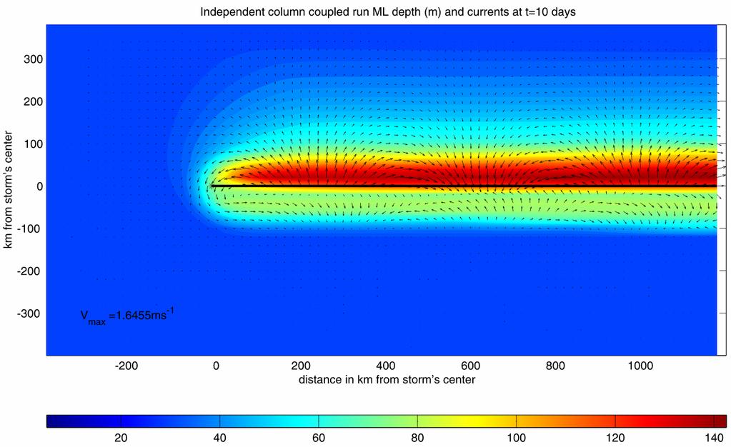
4 Ocean Component: ((Schade, L.R., 1997: A physical interpreatation of SST-feedback. Preprints of the 22 nd Conf. on Hurr. Trop. Meteor., Amer. Meteor. Soc., Boston, pgs ) Mixing by bulk-richardson number closure Mixed-layer current driven by hurricane model surface wind
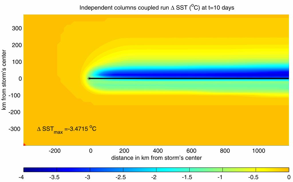
5 Ocean columns integrated only Along predicted storm track. Predicted storm center SST anomaly used for input to ALL atmospheric points.
6 Data Inputs: Weekly updated potential intensity (1 X 1 degree) Official track forecast and storm history (NHC & JTWC) Monthly climatological ocean mixed layer depths (1 X 1 degree) Monthly climatological sub-mixed layer thermal stratification (1 X 1 degree) Bathymetry (1/4 X 1/4 degree)
7 Initialization: Synthetic, warm core vortex specified at beginning of track Radial eddy flux of entropy at middle levels adjusted so as to match storm intensity to date This matching procedure effectively initializes middle tropospheric humidity as well as balanced flow
8 Comparison with same atmospheric model coupled to 3-D ocean model; idealized runs: Full model (black), string model (red)

9 Mixed layer depth and currents
10

11 SST Change
12
13
14 Landfall Algorithm: Enthalpy exchange coefficient decreases linearly with land elevation, reaching zero when h = 40 m This accounts in a crude way for heat fluxes from low-lying, swampy or marshy terrain
15 Real-Time Forecasts Posted at
16 Overall Forecast Performance: 2002 Atlantic Intensity Errors
17 70 Hurricane Gert occurred in a low-shear environment and moved over an ocean close to its climatological mean state. Gert, 1999 Maximum surface wind speed (m/s) Initialization period Observed Model September
18 Same simulation, but with fixed SST:
19 Sensitivity to initial intensity error and length of matching period:
20 Sensitivity to size of starting vortex
21 Model performs poorly when substantial shear is present, as in Chantal, 2001: 70 Chantal, 2001 Maximum surface wind speed (m s -1 ) Best track Model Initialization period August
22 hpa environmental shear: 12 Chantal, Shear (m s -1 ) August
23 Add ventilation term to model equation governing middle level θ e. Coefficient determined by matching model to long record of observations: θ t e ( ) θ θ e e0 = V V = V 2 V 2 max shear
24 Result:
25 But model sensitive to shear: This shows the results of varying Shear magnitude by +/- 5 kts and +/- 10 kts:
26 Presence of shear also makes model sensitive to initial conditions. Here the initial intensity is varied by +/- 3 m/s and +/- 6 m/s:
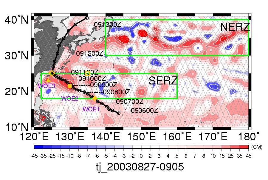
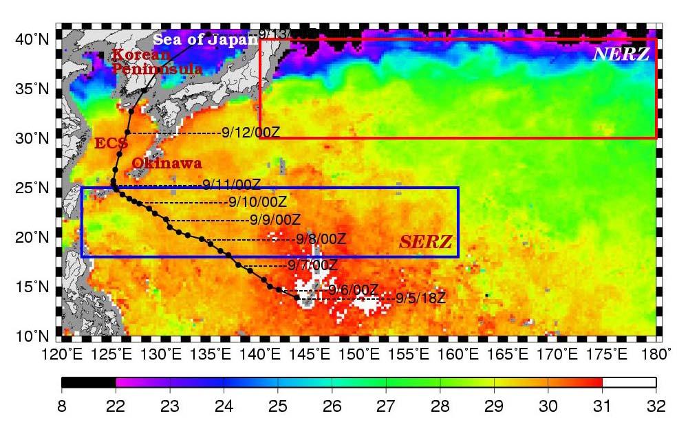
27 Some storms are influenced by upper ocean anomalies from monthly climatology. An example is that of Typhoon Maemi of 2003, which passed over a warm eddy in the western North Pacific:

28 Typhoon Maemi, 2003
29
30


31 η η upper-layer ρ upper 20 0 C isotherm ρlower ρ g = g ρ lower upper lower-layer ρ lower ~500km
32 Standard Simulation:
33 Using Sea Surface Altimetry to Estimate Upper Ocean Thermal Structure:
34
35 This shows model hindcasts with and without the ocean eddy, as estimated from sea surface altimetry data:

36 As TCs approach shore, shoaling water isolates surface mixed layer... surface cooling ceases.
37
38
39
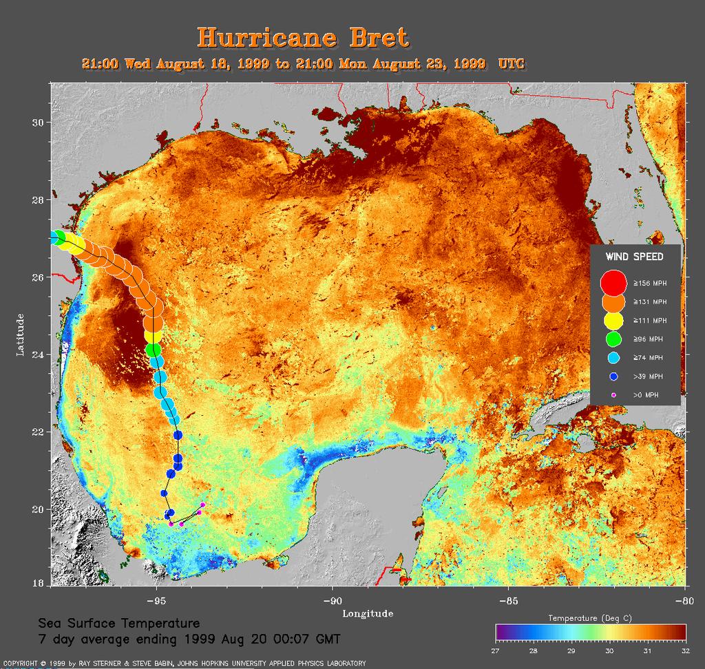
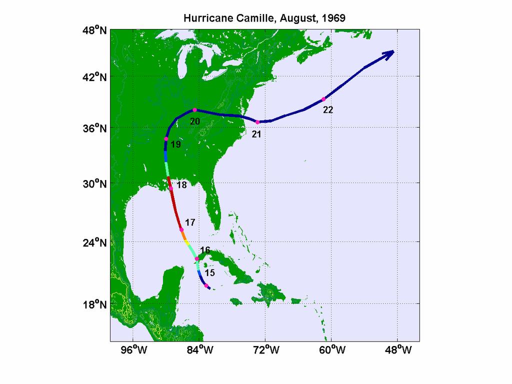
40 A good simulation of Camille can only be obtained by assuming that it traveled right up the axis of the Loop Current:
41 Mitch was also influenced by an ocean eddy. The red curve used TOPEX altimetry modified by de-aliasing the estimated peak amplitude:
42 Effect of standing water can be seen in these idealized simulations of storm landfall over dry land and over swamps with indicated depths of standing water:
43
44 Hurricane Andrew, with and without the effect of the Everglades, as represented by a elevation-dependent heat exchange coefficient:
45 Some storms may have large internal fluctuations (e.g. Allen). CHIPS may predict the existence of these, but not their phase:

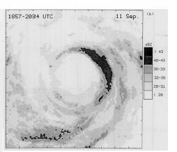
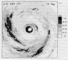
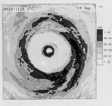
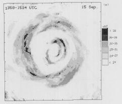
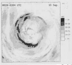
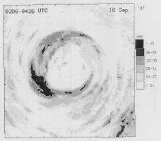
46 Concentric eyewalls in Hurricane Gilbert, 1988 (from Black and Willoughby, Mon. Wea. Rev., 1992)
47
48 Solid: Beginning of fllight; Dashed: End of flight; Dotted: Change/6hr
49

50
51 Environmental factors critical to intensity prediction: Potential intensity along track Upper ocean thermal structure Environmental wind shear Bathymetry Land surface characteristics
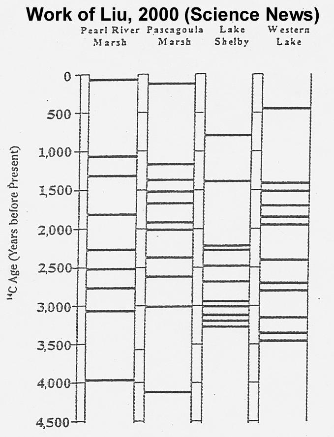
52 Major sources of uncertainty: Uncertain forecasts of vertical shear Shear reduces predictability Little real-time knowledge of upper ocean thermal structure Low predictability of internal variability
53 Hurricanes and Climate
54 Maximum Wind Speed (MPH) Sea Surface Temperature (F)
55 ANDREW,1992 Control 2 X CO Time (days) Maximum surface wind speed (m/s)
56 Empirical Index: I 3 3 V 2 = pot η H V, shear η 850 hpa absolute vorticity ( s 1 ), V pot Potential wind speed ( ms 1), H V shear 600 mb relative humidity (%), V V ( ms 1).
57 Atlantic
58 Western North Pacific
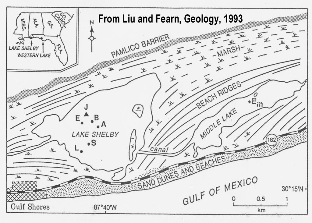
59 Paleotempestology
60 barrier beach a) backbarrier marsh overwash fan lagoon upland b) barrier beach backbarrier marsh overwash fan lagoon upland flood tidal delta terminal lobes Donnelly Figure 2
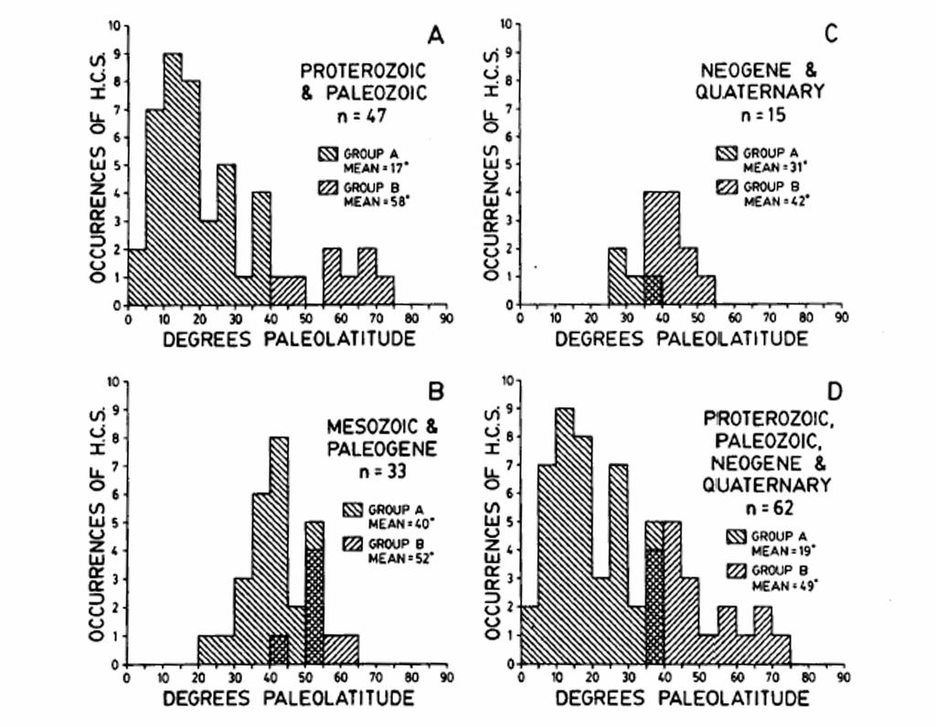
61
62 Whale Beach WB1 pre-1932 WB nor easter late 1700s or early 1800s probably 1821 Hurricane WB3 salt marsh peat mud with S. alterniflora fine sand Depth (cm) ( ) A.D A.D A.D ?? ( ) A.D A.D. Jeffrey Donnelly, WHOI
63 Beach Deposits Nott and Hayne, 2001
64
65 7 6 Number of events Years before present
66 Lake Inwash Deposits Noren et al., 2002

67 Core stratigraphies Sedimentation event histogram GISP2 sea salt GISP2 non-sea salt
68 Hummocky Cross-Stratification Duke, 1985
69
70 Brandt and Elias, 1989
71 Do tropical cyclones play a role in the climate system? The case for tropical cyclone control of the thermohaline circulation Feedback of tropical cyclone activity on climate
72 Tropical Cyclone-Climate Feedback Sensitive dependence of tropical cyclone frequency and intensity on tropical SSTs + Dependence of tropical SSTs on global tropical cyclone activity = Tropical thermostat
73 Ocean Feedback

74 Ocean Thermohaline Circulation
75 Heat Transport by Oceans and Atmosphere

76 A hot plate is brought in contact with the left half of the surface of a swimming pool of cold water. Heat diffuses downward and the warm water begins to rise. The strength of the circulation is controlled in part by the rate of heat diffusion. In the real world, this rate is very, very small.

77 Adding a stirring rod to this picture greatly enhances the circulation by mixing the warm water to greater depth and bringing more cold water in contact with the plate. The strength of the lateral heat flux is proportional to the 2/3 power of the power put into the stirring, and the 2/3 power of the temperature of the plate.
78 Coupled Ocean-Atmosphere model run for 67 of the 83 tropical cyclones that occurred in calendar year 1996 Accumulated TC-induced ocean heating divided by 366 days Result: Net column-integrated heating of ocean induced by global tropical cyclone activity: ( 1.4± 0.7) 1015W
79

80 Veronique Bugnion used an ocean model to calculate the sensitivity of the total poleward heat flux by the world oceans to the strength and distribution of vertical mixing. This sensitivity, shown here, is concentrated in the Tropics, where hurricanes occur.
81
82 These diagrams show the currents generated by a very localized source of vertical mixing at 20 o N and 25 o E. The upper diagram shows the currents near the top of the ocean, while the bottom diagram show currents closer to the bottom. Note in particular the strong northward flow of warm water along the western boundary of the ocean, near the surface. These plots have been generated using a complex ocean model set in a simple rectangular basin. Courtesy of Jeff Scott
83 Implications for Climate: Poleward Heat Flux F PI3 P PI3 FP 2 3 Poleward Heat Flux PI5 May be conservative, in view of Nolan s results
84 This plot shows a measure of El Niño/La Niña (green) and a measure of the power put into the far western Pacific Ocean by tropical cyclones (blue). The blue curve has been shifted rightward by two years on this graph. There is the suggestion that powerful cyclones in the western Pacific can trigger El Niño/La Niña cycles.
85
Lectures on Tropical Cyclones
 Lectures on Tropical Cyclones Chapter 1 Observations of Tropical Cyclones Outline of course Introduction, Observed Structure Dynamics of Mature Tropical Cyclones Equations of motion Primary circulation
ENVIRONMENTAL CONTROL OF TROPICAL CYCLONE INTENSITY
 ENVIRONMENTAL CONTROL OF TROPICAL CYCLONE INTENSITY Kerry Emanuel 1, Christopher DesAutels, Christopher Holloway and Robert Korty Program in Atmospheres, Oceans and Climate Massachusetts Institute of Technology
Thermodynamic and Flux Observations of the Tropical Cyclone Surface Layer
 Thermodynamic and Flux Observations of the Tropical Cyclone Surface Layer 1. INTRODUCTION Alex M. Kowaleski and Jenni L. Evans 1 The Pennsylvania State University, University Park, PA Understanding tropical
Tropical Cyclone Genesis: What we know, and what we don t!
 Tropical Cyclone Genesis: What we know, and what we don t! Allison Wing! NSF Postdoctoral Research Fellow! Lamont-Doherty Earth Observatory! Columbia University! Overview! Climatology! What We Know! Theories!
Presentation A simple model of multiple climate regimes
 A simple model of multiple climate regimes Kerry Emanuel March 21, 2012 Overview 1. Introduction 2. Essential Climate Feedback Processes Ocean s Thermohaline Circulation, Large-Scale Circulation of the
Annual Number of Peer Reviewed Articles with Hurricane or Tropical Cyclone in their Titles, according to Meteorological and Geoastrophysical
 Hurricanes and Climate Kerry Emanuel Program in Atmospheres, Oceans, and Climate MIT Program Potential Intensity Role of potential ti li intensity it in storm intensity it Role of potential intensity in
Hurricanes are intense vortical (rotational) storms that develop over the tropical oceans in regions of very warm surface water.
 storms that develop over the tropical oceans in regions of very warm surface water.") Hurricanes: Observations and Dynamics Houze Section 10.1. Holton Section 9.7. Emanuel, K. A., 1988: Toward a general theory of hurricanes. American Scientist, 76, 371-379 (web link). http://ww2010.atmos.uiuc.edu/(gh)/guides/mtr/hurr/home.rxml
Hurricanes: Observations and Dynamics Houze Section 10.1. Holton Section 9.7. Emanuel, K. A., 1988: Toward a general theory of hurricanes. American Scientist, 76, 371-379 (web link). http://ww2010.atmos.uiuc.edu/(gh)/guides/mtr/hurr/home.rxml
Evaluating a Genesis Potential Index with Community Climate System Model Version 3 (CCSM3) By: Kieran Bhatia
 By: Kieran Bhatia") Evaluating a Genesis Potential Index with Community Climate System Model Version 3 (CCSM3) By: Kieran Bhatia I. Introduction To assess the impact of large-scale environmental conditions on tropical cyclone
Evaluating a Genesis Potential Index with Community Climate System Model Version 3 (CCSM3) By: Kieran Bhatia I. Introduction To assess the impact of large-scale environmental conditions on tropical cyclone
The Impact of air-sea interaction on the extratropical transition of tropical cyclones
 The Impact of air-sea interaction on the extratropical transition of tropical cyclones Sarah Jones Institut für Meteorologie und Klimaforschung Universität Karlsruhe / Forschungszentrum Karlsruhe 1. Introduction
PRMS WHITE PAPER 2014 NORTH ATLANTIC HURRICANE SEASON OUTLOOK. June RMS Event Response
 PRMS WHITE PAPER 2014 NORTH ATLANTIC HURRICANE SEASON OUTLOOK June 2014 - RMS Event Response 2014 SEASON OUTLOOK The 2013 North Atlantic hurricane season saw the fewest hurricanes in the Atlantic Basin
Mélicie Desflots* RSMAS, University of Miami, Miami, Florida
 15B.6 RAPID INTENSITY CHANGE IN HURRICANE LILI (2002) Mélicie Desflots* RSMAS, University of Miami, Miami, Florida 1. INTRODUCTION Rapid intensity change in tropical cyclones is one of the most difficult
HWRF Ocean: MPIPOM-TC
 HWRF v3.7a Tutorial Nanjing, China, December 2, 2015 HWRF Ocean: MPIPOM-TC Ligia Bernardet NOAA SRL Global Systems Division, Boulder CO University of Colorado CIRS, Boulder CO Acknowledgement Richard Yablonsky
地球系统科学前沿讲座 台风研究现状和问题 林岩銮
 地球系统科学前沿讲座 台风研究现状和问题 林岩銮 2013.3.18 Satellite image of Hurricane Floyd approaching the east coast of Florida in 1999. The image has been digitally enhanced to lend a three-dimensional perspective. Credit:
Hurricanes: Their physics and relationship to climate. Kerry Emanuel Massachusetts Institute of Technology
 Hurricanes: Their physics and relationship to climate Kerry Emanuel Massachusetts Institute of Technology Topics Overview of Tropical Cyclones Tropical Cyclone Physics What have TCs been like in the past,
USING PROGRAM HURRICANE. Download all the files, including the (empty) output subdirectory into a new folder on your machine.
 output subdirectory into a new folder on your machine.") USING PROGRAM HURRICANE Download all the files, including the (empty) output subdirectory into a new folder on your machine. QuickStart: First compile hurr.f. Modify the first column of the input file
USING PROGRAM HURRICANE Download all the files, including the (empty) output subdirectory into a new folder on your machine. QuickStart: First compile hurr.f. Modify the first column of the input file
Inner core dynamics: Eyewall Replacement and hot towers
 Inner core dynamics: Eyewall Replacement and hot towers FIU Undergraduate Hurricane Internship Lecture 4 8/13/2012 Why inner core dynamics is important? Current TC intensity and structure forecasts contain
Initialization of Tropical Cyclone Structure for Operational Application
 DISTRIBUTION STATEMENT A. Approved for public release; distribution is unlimited. Initialization of Tropical Cyclone Structure for Operational Application PI: Tim Li IPRC/SOEST, University of Hawaii at
Comments by William M. Gray (Colorado State University) on the recently published paper in Science by Webster, et al
 on the recently published paper in Science by Webster, et al") Comments by William M. Gray (Colorado State University) on the recently published paper in Science by Webster, et al., titled Changes in tropical cyclone number, duration, and intensity in a warming environment
Comments by William M. Gray (Colorado State University) on the recently published paper in Science by Webster, et al., titled Changes in tropical cyclone number, duration, and intensity in a warming environment
Chapter 24 Tropical Cyclones
 Chapter 24 Tropical Cyclones Tropical Weather Systems Tropical disturbance a cluster of thunderstorms about 250 to 600 km in diameter, originating in the tropics or sub-tropics Tropical depression a cluster
A Preliminary Exploration of the Upper Bound of Tropical Cyclone Intensification
 A Preliminary Exploration of the Upper Bound of Tropical Cyclone Intensification Jonathan L. Vigh (NCAR/RAL) Kerry Emanuel (MIT) Mrinal K. Biswas (NCAR/RAL) Eric A. Hendricks (Naval Postgraduate School)
2013 ATLANTIC HURRICANE SEASON OUTLOOK. June RMS Cat Response
 2013 ATLANTIC HURRICANE SEASON OUTLOOK June 2013 - RMS Cat Response Season Outlook At the start of the 2013 Atlantic hurricane season, which officially runs from June 1 to November 30, seasonal forecasts
Link between Hurricanes and Climate Change: SST
 Link between Hurricanes and Climate Change: SST FRIDAY: PROJECT 2 Proposals due! Bring laptops on weds (at least one per group)! Discuss assessment on Weds. Roger Francois will talk on Friday about the
Hurricane Science Tutorial. Kerry Emanuel Lorenz Center, MIT
 Hurricane Science Tutorial Kerry Emanuel Lorenz Center, MIT Why Should You Care? Forecasting Much progress in social science of response to warnings, requests to evacuate, etc. Forecasters are ambassadors
Intensity of North Indian Ocean Tropical Cyclones
 Chapter 6 Intensity of North Indian Ocean Tropical Cyclones 6.1 Introduction Intensity of tropical cyclones is dependent on several parameters both thermodynamic and dynamic. It includes thermodynamic
The 2009 Hurricane Season Overview
 The 2009 Hurricane Season Overview Jae-Kyung Schemm Gerry Bell Climate Prediction Center NOAA/ NWS/ NCEP 1 Overview outline 1. Current status for the Atlantic, Eastern Pacific and Western Pacific basins
Hurricane Intensity: Governing Factors and Forecasting Challenges. EAS 470 Final Paper Allison Wing
 Hurricane Intensity: Governing Factors and Forecasting Challenges EAS 470 Final Paper Allison Wing Tropical cyclones are undoubtedly among the mostly deadly and destructive natural phenomena found on Earth
Thermodynamic control of hurricane intensity
 Thermodynamic control of hurricane intensity Kerry A. Emanuel articles Program in Atmospheres, Oceans, and Climate, Massachusetts Institute of Technology, Cambridge, Massachusetts 02139, USA... To establish
Chapter 24. Tropical Cyclones. Tropical Cyclone Classification 4/19/17
 Chapter 24 Tropical Cyclones Tropical Cyclones Most destructive storms on the planet Originate over tropical waters, but their paths often take them over land and into midlatitudes Names Hurricane (Atlantic
Introduction to Meteorology & Climate. Climate & Earth System Science. Atmosphere Ocean Interactions. A: Structure of the Ocean.
 Climate & Earth System Science Introduction to Meteorology & Climate MAPH 10050 Peter Lynch Peter Lynch Meteorology & Climate Centre School of Mathematical Sciences University College Dublin Meteorology
Comments on: Increasing destructiveness of tropical cyclones over the past 30 years by Kerry Emanuel, Nature, 31 July 2005, Vol. 436, pp.
 Comments on: Increasing destructiveness of tropical cyclones over the past 30 years by Kerry Emanuel, Nature, 31 July 2005, Vol. 436, pp. 686-688 William M. Gray Department of Atmospheric Science Colorado
The Effect of Sea Spray on Tropical Cyclone Intensity
 The Effect of Sea Spray on Tropical Cyclone Intensity Jeffrey S. Gall, Young Kwon, and William Frank The Pennsylvania State University University Park, Pennsylvania 16802 1. Introduction Under high-wind
1. Introduction. In following sections, a more detailed description of the methodology is provided, along with an overview of initial results.
 7B.2 MODEL SIMULATED CHANGES IN TC INTENSITY DUE TO GLOBAL WARMING Kevin A. Hill*, Gary M. Lackmann, and A. Aiyyer North Carolina State University, Raleigh, North Carolina 1. Introduction The impact of
Analysis of Fall Transition Season (Sept-Early Dec) Why has the weather been so violent?
 Why has the weather been so violent?") WEATHER TOPICS Analysis of Fall Transition Season (Sept-Early Dec) 2009 Why has the weather been so violent? As can be seen by the following forecast map, the Fall Transition and early Winter Season of
WEATHER TOPICS Analysis of Fall Transition Season (Sept-Early Dec) 2009 Why has the weather been so violent? As can be seen by the following forecast map, the Fall Transition and early Winter Season of
DISTRIBUTION STATEMENT A: Distribution approved for public release; distribution is unlimited.
 DISTRIBUTION STATEMENT A: Distribution approved for public release; distribution is unlimited. INITIALIZATION OF TROPICAL CYCLONE STRUCTURE FOR OPERTAIONAL APPLICATION PI: Tim Li IPRC/SOEST, University
Tropical cyclone simulations and predictions with GFDL s prototype global cloud resolving model
 Tropical cyclone simulations and predictions with GFDL s prototype global cloud resolving model S.-J. Lin and GFDL model development teams NOAA/Geophysical Fluid Dynamics Laboratory Workshop on High-Resolution
Impacts of Turbulence on Hurricane Intensity
 Impacts of Turbulence on Hurricane Intensity Yongsheng Chen Department of Earth and Space Science and Engineering York University, 4700 Keele Street, Toronto, Ontario, M3J 1P3 Phone: (416) 736-2100 ext.40124
Analysis of Mixing and Dynamics Associated with the Dissolution of Hurricane-Induced Cold Wakes
 DISTRIBUTION STATEMENT A: Approved for public release; distribution is unlimited. Analysis of Mixing and Dynamics Associated with the Dissolution of Hurricane-Induced Cold Wakes Carol Anne Clayson Dept.
Transient/Eddy Flux. Transient and Eddy. Flux Components. Lecture 7: Disturbance (Outline) Why transients/eddies matter to zonal and time means?
 Why transients/eddies matter to zonal and time means?") Lecture 7: Disturbance (Outline) Transients and Eddies Climate Roles Mid-Latitude Cyclones Tropical Hurricanes Mid-Ocean Eddies (From Weather & Climate) Flux Components (1) (2) (3) Three components contribute
Lecture 7: Disturbance (Outline) Transients and Eddies Climate Roles Mid-Latitude Cyclones Tropical Hurricanes Mid-Ocean Eddies (From Weather & Climate) Flux Components (1) (2) (3) Three components contribute
A Perfect Storm: The Collision of Tropical Cyclones, Climate Change and Coastal Population Growth. Jeff Donnelly Woods Hole Oceanographic Institution
 A Perfect Storm: The Collision of Tropical Cyclones, Climate Change and Coastal Population Growth Jeff Donnelly Woods Hole Oceanographic Institution Recent Hurricane Trends What Might the Future Hold?
- tornadoes. Further Reading: Chapter 08 of the text book. Outline. -tropical storms. -Storm surge
 (1 of 12) Further Reading: Chapter 08 of the text book Outline - tornadoes -tropical storms -Storm surge (2 of 12) Introduction Previously, We talked about fronts and their relationship to air masses Also
Climate Forecast Applications Network (CFAN)
") Forecast of 2018 Atlantic Hurricane Activity April 5, 2018 Summary CFAN s inaugural April seasonal forecast for Atlantic tropical cyclone activity is based on systematic interactions among ENSO, stratospheric
Forecast of 2018 Atlantic Hurricane Activity April 5, 2018 Summary CFAN s inaugural April seasonal forecast for Atlantic tropical cyclone activity is based on systematic interactions among ENSO, stratospheric
A Reformulation of the Logistic Growth Equation Model (LGEM) for Ensemble and Extended Range Intensity Prediction
 for Ensemble and Extended Range Intensity Prediction") A Reformulation of the Logistic Growth Equation Model (LGEM) for Ensemble and Extended Range Intensity Prediction Mark DeMaria NOAA/NESDIS, Fort Collins, CO Andrea Schumacher and Kate Musgrave CIRA/CSU,
A Reformulation of the Logistic Growth Equation Model (LGEM) for Ensemble and Extended Range Intensity Prediction Mark DeMaria NOAA/NESDIS, Fort Collins, CO Andrea Schumacher and Kate Musgrave CIRA/CSU,
An Introduction to Coupled Models of the Atmosphere Ocean System
 An Introduction to Coupled Models of the Atmosphere Ocean System Jonathon S. Wright jswright@tsinghua.edu.cn Atmosphere Ocean Coupling 1. Important to climate on a wide range of time scales Diurnal to
A Tropical Cyclone with a Very Large Eye
 JANUARY 1999 PICTURES OF THE MONTH 137 A Tropical Cyclone with a Very Large Eye MARK A. LANDER University of Guam, Mangilao, Guam 9 September 1997 and 2 March 1998 1. Introduction The well-defined eye
Impact of Stochastic Convection on Ensemble Forecasts of Tropical Cyclone Development
 620 M O N T H L Y W E A T H E R R E V I E W VOLUME 139 Impact of Stochastic Convection on Ensemble Forecasts of Tropical Cyclone Development ANDREW SNYDER AND ZHAOXIA PU Department of Atmospheric Sciences,
Tropical Cyclone Genesis and Sudden Changes of Track and Intensity in the Western Pacific
 Tropical Cyclone Genesis and Sudden Changes of Track and Intensity in the Western Pacific PI: Bin Wang Co-PI: Yuqing Wang and Tim Li Department of Meteorology and International Pacific Research Center
July Forecast Update for North Atlantic Hurricane Activity in 2018
 July Forecast Update for North Atlantic Hurricane Activity in 2018 Issued: 5 th July 2018 by Professor Mark Saunders and Dr Adam Lea Dept. of Space and Climate Physics, UCL (University College London),
August Forecast Update for Atlantic Hurricane Activity in 2012
 August Forecast Update for Atlantic Hurricane Activity in 2012 Issued: 6 th August 2012 by Professor Mark Saunders and Dr Adam Lea Dept. of Space and Climate Physics, UCL (University College London), UK
Ocean-Atmosphere Interactions and El Niño Lisa Goddard
 Ocean-Atmosphere Interactions and El Niño Lisa Goddard Advanced Training Institute on Climatic Variability and Food Security 2002 July 9, 2002 Coupled Behavior in tropical Pacific SST Winds Upper Ocean
FORECAST OF ATLANTIC SEASONAL HURRICANE ACTIVITY AND LANDFALL STRIKE PROBABILITY FOR 2015
 FORECAST OF ATLANTIC SEASONAL HURRICANE ACTIVITY AND LANDFALL STRIKE PROBABILITY FOR 2015 We continue to foresee a below-average 2015 Atlantic hurricane season. A moderate to strong El Niño is underway,
the 2 past three decades
 SUPPLEMENTARY INFORMATION DOI: 10.1038/NCLIMATE2840 Atlantic-induced 1 pan-tropical climate change over the 2 past three decades 3 4 5 6 7 8 9 10 POP simulation forced by the Atlantic-induced atmospheric
Adiabatic expansion Isothermal compression Adiabatic compression
 Tropical Cyclones: Steady State Physics 1 Energy Production 2 Carnot Theorem: Maximum efficiency results from a pa rticular energy e cycle: Isothermal expansion Adiabatic expansion Isothermal compression
The Tropical Atmosphere: Hurricane Incubator
 The Tropical Atmosphere: Hurricane Incubator Images from journals published by the American Meteorological Society are copyright AMS and used with permission. A One-Dimensional Description of the Tropical
Lecture 1. Amplitude of the seasonal cycle in temperature
 Lecture 6 Lecture 1 Ocean circulation Forcing and large-scale features Amplitude of the seasonal cycle in temperature 1 Atmosphere and ocean heat transport Trenberth and Caron (2001) False-colour satellite
August Forecast Update for Atlantic Hurricane Activity in 2016
 August Forecast Update for Atlantic Hurricane Activity in 2016 Issued: 5 th August 2016 by Professor Mark Saunders and Dr Adam Lea Dept. of Space and Climate Physics, UCL (University College London), UK
Precipitation Structure and Processes of Typhoon Nari (2001): A Modeling Propsective
: A Modeling Propsective") Precipitation Structure and Processes of Typhoon Nari (2001): A Modeling Propsective Ming-Jen Yang Institute of Hydrological Sciences, National Central University 1. Introduction Typhoon Nari (2001) struck
Precipitation Structure and Processes of Typhoon Nari (2001): A Modeling Propsective Ming-Jen Yang Institute of Hydrological Sciences, National Central University 1. Introduction Typhoon Nari (2001) struck
1. Sea Surface Temperatures (SSTs) > 27 and extending to some depth.
 > 27 and extending to some depth.") Formation Factors for Hurricanes 1. Sea Surface Temperatures (SSTs) > 27 and extending to some depth. 2. Location >5 away from the equator (usually 10 ). Coriolis force is necessary for rotation. 3. High
Formation Factors for Hurricanes 1. Sea Surface Temperatures (SSTs) > 27 and extending to some depth. 2. Location >5 away from the equator (usually 10 ). Coriolis force is necessary for rotation. 3. High
( ) = 1005 J kg 1 K 1 ;
 = 1005 J kg 1 K 1 ;") Problem Set 3 1. A parcel of water is added to the ocean surface that is denser (heavier) than any of the waters in the ocean. Suppose the parcel sinks to the ocean bottom; estimate the change in temperature
Problem Set 3 1. A parcel of water is added to the ocean surface that is denser (heavier) than any of the waters in the ocean. Suppose the parcel sinks to the ocean bottom; estimate the change in temperature
Vertical mixing and the ocean circulation. Chris Brierley, Postdoc Luncheon, 14 th April 2010
 Vertical mixing and the ocean circulation Chris Brierley, Postdoc Luncheon, 14 th April 2010 Vertical mixing what and why What is its global impact? Mean climate Climate change Changing sources of mixing
Q & A on Trade-off between intensity and frequency of global tropical cyclones
 SUPPLEMENTARY INFORMATION DOI: 10.1038/NCLIMATE2646 Q & A on Trade-off between intensity and frequency of global tropical cyclones Nam-Young Kang & James B. Elsner List of questions 1. What is new in this
11A.3 The Impact on Tropical Cyclone Predictions of a Major Upgrade to the Met Office Global Model
 11A.3 The Impact on Tropical Cyclone Predictions of a Major Upgrade to the Met Office Global Model Julian T. Heming * Met Office, Exeter, UK 1. BACKGROUND TO MODEL UPGRADE The last major upgrade to the
At the Midpoint of the 2008
 At the Midpoint of the 2008 Atlantic Hurricane Season Editor s note: It has been an anxious couple of weeks for those with financial interests in either on- or offshore assets in the Gulf of Mexico and
Research on Climate of Typhoons Affecting China
 Research on Climate of Typhoons Affecting China Xu Ming Shanghai Typhoon Institute November,25 Outline 1. Introduction 2. Typhoon disasters in China 3. Climatology and climate change of typhoon affecting
TROPICAL-EXTRATROPICAL INTERACTIONS
 Notes of the tutorial lectures for the Natural Sciences part by Alice Grimm Fourth lecture TROPICAL-EXTRATROPICAL INTERACTIONS Anomalous tropical SST Anomalous convection Anomalous latent heat source Anomalous
April Forecast Update for North Atlantic Hurricane Activity in 2019
 April Forecast Update for North Atlantic Hurricane Activity in 2019 Issued: 5 th April 2019 by Professor Mark Saunders and Dr Adam Lea Dept. of Space and Climate Physics, UCL (University College London),
Hurricanes. April 14, 2009
 Tropical Weather & Hurricanes Chapter 15 April 14, 2009 Tropical meteorology Tropics characterized by seasonal wet and drier periods- wet when sun is nearly overhead at noon and inter-tropical convergence
Lecture 18 Hurricanes
 Lecture 18 Hurricanes Part I Structure and Climatology What is a hurricane? What is the structure or anatomy of a hurricane? How to build a hurricane - hurricane energy Hurricane climatology - when and
1. Introduction. 3. Climatology of Genesis Potential Index. Figure 1: Genesis potential index climatology annual
 C. ENSO AND GENESIS POTENTIAL INDEX IN REANALYSIS AND AGCMS Suzana J. Camargo, Kerry A. Emanuel, and Adam H. Sobel International Research Institute for Climate and Society, Columbia Earth Institute, Palisades,
Why There Is Weather?
 Lecture 6: Weather, Music Of Our Sphere Weather and Climate WEATHER The daily fluctuations in atmospheric conditions. The atmosphere on its own can produce weather. (From Understanding Weather & Climate)
OCN/ATM/ESS 587. Ocean circulation, dynamics and thermodynamics.
 OCN/ATM/ESS 587 Ocean circulation, dynamics and thermodynamics. Equation of state for seawater General T/S properties of the upper ocean Heat balance of the upper ocean Upper ocean circulation Deep circulation
July Forecast Update for Atlantic Hurricane Activity in 2016
 July Forecast Update for Atlantic Hurricane Activity in 2016 Issued: 5 th July 2016 by Professor Mark Saunders and Dr Adam Lea Dept. of Space and Climate Physics, UCL (University College London), UK Forecast
Lecture 1. Equations of motion - Newton s second law in three dimensions. Pressure gradient + force force
 Lecture 3 Lecture 1 Basic dynamics Equations of motion - Newton s second law in three dimensions Acceleration = Pressure Coriolis + gravity + friction gradient + force force This set of equations is the
Tropical Cyclones: Steady State Physics
 Tropical Cyclones: Steady State Physics Energy Production Carnot Theorem: Maximum efficiency results from a particular energy cycle: Isothermal expansion Adiabatic expansion Isothermal compression Adiabatic
Can CMIP5 models replicate long-term variability of storm characteristics in the WNP? James Bramante
 Can CMIP5 models replicate long-term variability of storm characteristics in the WNP? James Bramante The Western North Pacific Figure taken from Laing and Evans (2011). Introduction to Tropical Meteorology.
Improved Tropical Cyclone Boundary Layer Wind Retrievals. From Airborne Doppler Radar
 Improved Tropical Cyclone Boundary Layer Wind Retrievals From Airborne Doppler Radar Shannon L. McElhinney and Michael M. Bell University of Hawaii at Manoa Recent studies have highlighted the importance
Dynamics of the Zonal-Mean, Time-Mean Tropical Circulation
 Dynamics of the Zonal-Mean, Time-Mean Tropical Circulation First consider a hypothetical planet like Earth, but with no continents and no seasons and for which the only friction acting on the atmosphere
Scale Interactions during the Formation of Typhoon Irving 边建谱 ELIZABETH A. RITCHIE GREG J. HOLLAND
 Scale Interactions during the Formation of Typhoon Irving 边建谱 ELIZABETH A. RITCHIE GREG J. HOLLAND Pre-research Fujiwhara: laboratory experiments in water (1921, 1923, 1931). Cloud clusters are a well-known
Atmosphere-Ocean Interaction in Tropical Cyclones
 Atmosphere-Ocean Interaction in Tropical Cyclones Isaac Ginis University of Rhode Island Collaborators: T. Hara, Y.Fan, I-J Moon, R. Yablonsky. ECMWF, November 10-12, 12, 2008 Air-Sea Interaction in Tropical
- tornadoes. Further Reading: Chapter 08 of the text book. Outline. - cyclones and anti-cyclones. -tropical storms. -Storm surge
 (1 of 16) Further Reading: Chapter 08 of the text book Outline - cyclones and anti-cyclones - tornadoes -tropical storms -Storm surge (2 of 16) Introduction Previously, We talked about fronts and their
11A.1 PREDICTION OF TROPICAL CYCLONE TRACK FORECAST ERROR FOR HURRICANES KATRINA, RITA, AND WILMA
 11A.1 PREDICTION OF TROPICAL CYCLONE TRACK FORECAST ERROR FOR HURRICANES KATRINA, RITA, AND WILMA James S. Goerss* Naval Research Laboratory, Monterey, California 1. INTRODUCTION Consensus tropical cyclone
Predicting Tropical Cyclone Formation and Structure Change
 Predicting Tropical Cyclone Formation and Structure Change Patrick A. Harr Department of Meteorology Naval Postgraduate School Monterey, CA 93943-5114 Telephone: (831)656-3787 FAX:(831)656-3061 email:
An upper to mid level circulation (Low) in the NW Caribbean is
 in the NW Caribbean is") WEEKLY WEATHER OUTLOOK BELIZE, CENTRAL AMERICA PERIOD: Monday-Monday, Oct. 1 October 8, 2012 DATE ISSUED: Monday, Oct 1, 2012 6:00 am RFrutos EcoSolutions & Services SYNOPSIS: An upper to mid level circulation
WEEKLY WEATHER OUTLOOK BELIZE, CENTRAL AMERICA PERIOD: Monday-Monday, Oct. 1 October 8, 2012 DATE ISSUED: Monday, Oct 1, 2012 6:00 am RFrutos EcoSolutions & Services SYNOPSIS: An upper to mid level circulation
4. Climatic changes. Past variability Future evolution
 4. Climatic changes Past variability Future evolution TROPICAL CYCLONES and CLIMATE How TCs have varied during recent and distant past? How will TC activity vary in the future? 2 CURRENT CLIMATE : how
August Forecast Update for Atlantic Hurricane Activity in 2015
 August Forecast Update for Atlantic Hurricane Activity in 2015 Issued: 5 th August 2015 by Professor Mark Saunders and Dr Adam Lea Dept. of Space and Climate Physics, UCL (University College London), UK
Why the Atlantic was surprisingly quiet in 2013
 1 Why the Atlantic was surprisingly quiet in 2013 by William Gray and Phil Klotzbach Preliminary Draft - March 2014 (Final draft by early June) ABSTRACT This paper discusses the causes of the unusual dearth
Variations of Typhoon Activity in Asia - Global Warming and/or Natural Cycles?
 Variations of Typhoon Activity in Asia - Global Warming and/or Natural Cycles? Johnny Chan Guy Carpenter Asia-Pacific Climate Impact Centre City University of Hong Kong Tropical Cyclones Affecting the
Atmospheric Sciences 321. Science of Climate. Lecture 13: Surface Energy Balance Chapter 4
 Atmospheric Sciences 321 Science of Climate Lecture 13: Surface Energy Balance Chapter 4 Community Business Check the assignments HW #4 due Wednesday Quiz #2 Wednesday Mid Term is Wednesday May 6 Practice
The Planetary Circulation System
 12 The Planetary Circulation System Learning Goals After studying this chapter, students should be able to: 1. describe and account for the global patterns of pressure, wind patterns and ocean currents
A Sensitivity Study of the Thermodynamic Environment on GFDL Model Hurricane Intensity: Implications for Global Warming
 109 A Sensitivity Study of the Thermodynamic Environment on GFDL Model Hurricane Intensity: Implications for Global Warming WEIXING SHEN Graduate School of Oceanography, University of Rhode Island, Narragansett,
Examination of Tropical Cyclogenesis using the High Temporal and Spatial Resolution JRA-25 Dataset
 Examination of Tropical Cyclogenesis using the High Temporal and Spatial Resolution JRA-25 Dataset Masato Sugi Forecast Research Department, Meteorological Research Institute, Japan Correspondence: msugi@mri-jma.go.jp
Improving Air-Sea Coupling Parameterizations in High-Wind Regimes
 Improving Air-Sea Coupling Parameterizations in High-Wind Regimes PI: Dr. Shuyi S. Chen Co-PI: Dr. Mark A. Donelan Rosenstiel School of Marine and Atmospheric Science, University of Miami 4600 Rickenbacker
Extratropical transition of tropical cyclones: Operational forecasting challenges. Matthew Kucas Joint Typhoon Warning Center Pearl Harbor, HI, USA
 Extratropical transition of tropical cyclones: Operational forecasting challenges Matthew Kucas Joint Typhoon Warning Center Pearl Harbor, HI, USA Outline Motivation for discussion Brief overview of tropical
Weather & Ocean Currents
 Weather & Ocean Currents Earth is heated unevenly Causes: Earth is round Earth is tilted on an axis Earth s orbit is eliptical Effects: Convection = vertical circular currents caused by temperature differences
Tropical Cyclone Formation/Structure/Motion Studies
 Tropical Cyclone Formation/Structure/Motion Studies Patrick A. Harr Department of Meteorology Naval Postgraduate School Monterey, CA 93943-5114 phone: (831) 656-3787 fax: (831) 656-3061 email: paharr@nps.edu
Dynamics and Kinematics
 Geophysics Fluid Dynamics () Syllabus Course Time Lectures: Tu, Th 09:30-10:50 Discussion: 3315 Croul Hall Text Book J. R. Holton, "An introduction to Dynamic Meteorology", Academic Press (Ch. 1, 2, 3,
P2.57 Cyclone Yasi Storm Surge in Australia Implications for Catastrophe Modeling
 P2.57 Cyclone Yasi Storm Surge in Australia Implications for Catastrophe Modeling Kevin A. Hill*, Peter Sousounis, and Jason Butke AIR Worldwide Corporation, Boston, Massachusetts 1. INTRODUCTION Storm
A New Ocean Mixed-Layer Model Coupled into WRF
 ATMOSPHERIC AND OCEANIC SCIENCE LETTERS, 2012, VOL. 5, NO. 3, 170 175 A New Ocean Mixed-Layer Model Coupled into WRF WANG Zi-Qian 1,2 and DUAN An-Min 1 1 The State Key Laboratory of Numerical Modeling
Tropical Cyclones-Ocean interaction as represented by a 25km resolution CGCM: the role of the coupling frequency
 HRCP Workshop 13-15 April 2016 Tropical Cyclones-Ocean interaction as represented by a 25km resolution CGCM: the role of the coupling frequency Enrico Scoccimarro (1,2), P.G. Fogli (2), K. Reed (3), S.
Geophysics Fluid Dynamics (ESS228)
") Geophysics Fluid Dynamics (ESS228) Course Time Lectures: Tu, Th 09:30-10:50 Discussion: 3315 Croul Hall Text Book J. R. Holton, "An introduction to Dynamic Meteorology", Academic Press (Ch. 1, 2, 3, 4,
Geophysics Fluid Dynamics (ESS228) Course Time Lectures: Tu, Th 09:30-10:50 Discussion: 3315 Croul Hall Text Book J. R. Holton, "An introduction to Dynamic Meteorology", Academic Press (Ch. 1, 2, 3, 4,
and 24 mm, hPa lapse rates between 3 and 4 K km 1, lifted index values
 3.2 Composite analysis 3.2.1 Pure gradient composites The composite initial NE report in the pure gradient northwest composite (N = 32) occurs where the mean sea level pressure (MSLP) gradient is strongest