The cientificworldjournal. Sujata Pattanayak, U. C. Mohanty, and Krishna K. Osuri. 1. Introduction
|
|
|
- Domenic Gibbs
- 5 years ago
- Views:
Transcription
1 The Scientific World Journal Volume 12, Article ID , 18 pages doi:1.1/12/ The cientificworldjournal Research Article Impact of Parameterization of Physical Processes on Simulation of Track and Intensity of Tropical Cyclone Nargis (8) with WRF-NMM Model Sujata Pattanayak, U. C. Mohanty, and Krishna K. Osuri Centre for Atmospheric Sciences, Indian Institute of Technology, Delhi, Hauz Khas, New Delhi 116, India Correspondence should be addressed to Sujata Pattanayak, Received 11 January 12; Accepted 4 March 12 Academic Editors: L. Leslie and C. Ottle Copyright 12 Sujata Pattanayak et al. This is an open access article distributed under the Creative Commons Attribution License, which permits unrestricted use, distribution, and reproduction in any medium, provided the original work is properly cited. The present study is carried out to investigate the performance of different cumulus convection, planetary boundary layer, land surface processes, and microphysics parameterization schemes in the simulation of a very severe cyclonic storm (VSCS) Nargis (8), developed in the central Bay of Bengal on 27 April 8. For this purpose, the nonhydrostatic mesoscale model (NMM) dynamic core of weather research and forecasting (WRF) system is used. Model-simulated track positions and intensity in terms of minimum central mean sea level pressure (MSLP), maximum surface wind (1 m), and precipitation are verified with observations as provided by the India Meteorological Department (IMD) and Tropical Rainfall Measurement Mission (TRMM). The estimated optimum combination is reinvestigated with six different initial conditions of the same case to have better conclusion on the performance of WRF-NMM. A few more diagnostic fields like vertical velocity, vorticity, and heat fluxes are also evaluated. The results indicate that cumulus convection play an important role in the movement of the cyclone, and PBL has a crucial role in the intensification of the storm. The combination of Simplified Arakawa Schubert (SAS) convection, Yonsei University (YSU) PBL, NMM land surface, and Ferrier microphysics parameterization schemes in WRF-NMM give better track and intensity forecast with minimum vector displacement error. 1. Introduction Tropical cyclones are serious threats to human life and property. Even with the recent rapid improvements in numerical weather prediction, tropical cyclone forecasting remains a challenging problem to atmospheric modeling groups. The Bay of Bengal is a potentially active region for development of cyclonic storms and an average of five tropical cyclones annually forms over the region, representing 5.85% of the global frequency [1]. Moreover, the Bay of Bengal storms are exceptionally devastating, especially when they make landfall [2]. This is mainly due to a densely populated and low lying coastline. With the Bay of Bengal tropical cyclones being the deadliest natural disasters in the Indian subcontinent, it significantly impacts the socioeconomic conditions of the countries bordering the east coast of India. Cumulus convection, surface fluxes of heat, moisture, and momentum and vertical mixing in the PBL play important roles in the development of tropical cyclones [3]. Convection has long been recognized as a process of central importance in the development of cyclonic storms. The scales of convective clouds are too small to be resolved by the numerical models and hence need to be parameterized in terms of variables defined at each grid point. A number of parameterization schemes have been developed over the years but each have their respective limitations [4, 5]. Performance of a numerical model in tropical cyclone forecasts depends on how well the convection is parameterized in the model [6, 7]. These studies have led to an increased understanding of the importance of the boundary layer and convective processes in the tropical cyclone development. An extensive study is carried out on the impact of the parameterization of physical processes in the simulation of two severe
2 2 The Scientific World Journal cyclonic storms developed over the Bay of Bengal using the MM5 model [7]. This study with MM5 model suggested that the combination of MRF and Grell (or Betts-Miller) for PBL and convection schemes, respectively, consistently give better results than the other combinations. The sensitivity experiments of convection, boundary layer, and moisture processes using the MM5 model for the prediction of the Orissa Super Cyclone 1999 is carried out by Bhaskar Rao andhariprasad[8] and the study suggested that convective processes plays an important role in the cyclone track prediction while the PBL controls intensification. A comparison study of four PBL parameterization schemes in simulation of Hurricane Bob (1991) is presented [9] using the MM5 model. This study suggested that significant sensitivity is seen in the central pressure and maximum surface wind (1 m). The precipitation forecast in hurricanes can be just as sensitive to the formulation of the different PBL schemes. The customization of Advanced Research WRF (WRF-ARW) model is also carried out[1] for the tropical cyclones over North Indian Ocean which suggested that the combination of KF cumulus convection scheme along with the YSU PBL is providing better track and intensity forecast. All the abovementioned studies clearly demonstrate the impact of the parameterization of physical processes in different fields of studies using the MM5 and WRF-ARW models. So, there is a need to investigate the impact of the parameterization of physical processes in simulation of tropical cyclones over the Bay of Bengal using NMM dynamic core of the WRF (WRF- NMM) model. In the present study, NCEP mesoscale model WRF- NMM is used to simulate a very severe cyclone Nargis with sensitivity experiments carried out to explore the impact of physical parameterizations on track and intensity prediction. The sensitivity of the model simulations to initial conditions is also explored using the optimum combination of physical parameterizations. A brief description of the model as well as the parameterization schemes used in the study is presented in Section 2. The synoptic situation for the above-mentioned cyclone used in the present study is described in Section 3. Various numerical experiments and data used are described in Section 4. Model simulated results along with the evaluation of performance of the model with different initial conditions are presented in Section 5 with the conclusions in Section Model Description The WRF-NMM version 3..1 developed by National Center for Environmental Prediction (NCEP)/National Oceanic and Atmospheric Administration (NOAA) is designed to be a flexible, state-of-the-art mesoscale modeling system. It is a fully compressible, nonhydrostatic model with a hydrostatic option [11 13]. Its vertical coordinate is a hybrid sigmapressure coordinate. The grid staggering is the Arakawa E-grid. The dynamics conserve a number of first- and second-order quantities including energy and enstrophy [14]. Forward-backward time integration scheme is used for the horizontally propagating fast waves and implicit scheme is used for the vertically propagating sound waves. Adams- Bashforth scheme for horizontal advection and Crank- Nicholson scheme for vertical advection are used by the model. The same time step is used for all terms. The Geophysical Fluid Dynamic Laboratory (GFDL) long-wave and short-wave radiation schemes are incorporated in the model. Additionally, to represent deep, moist convection in the model, various parameterizations schemes are included. All the schemes considered for this study are reasonably independent and hence useful for sensitivity experiments Planetary Boundary Layer Schemes. The Yonsei University (YSU) PBL scheme is a revised vertical diffusion package with a nonlocal turbulent mixing coefficient in the boundary layer. The major ingredient of the revision is the inclusion of an explicit treatment of entrainment processes at the top of the PBL. The YSU PBL increases boundary layer mixing in the thermally induced free convection regime and decreases it in the mechanically induced forced convection regime, which alleviates the well-known problems in the Medium- Range Forecast (MRF) PBL. Excessive mixing in the mixed layer in the presence of strong winds is resolved. Overly rapid growth of the PBL in the case of the Hong and Pan (1996) [15] is also rectified. Consequently, the YSU scheme does a better job in reproducing the convective inhibition. The Mellor Yamada Janjic (MYJ) PBL scheme is a onedimensional prognostic turbulent kinetic energy scheme with local vertical mixing [12, 13]. An advantage of the MYJ scheme is that it allows advection of turbulent regions during the forecast. The top of the layer depends on the TKE as well as the buoyancy and shear of the driving flow. The NCEP Global Forecast System (NCEP GFS) PBL scheme is a nonlocal vertical diffusion scheme [16] and further described in Hong and Pan (1996). The PBL height is determined using an iterative bulk-richardson approach working from the ground upward whereupon the profile of the diffusivity coefficient is specified as a cubic function of the PBL height. Coefficient values are obtained by matching the surface layer fluxes. A counter-gradient flux parameterization is included Cumulus Parameterization Schemes. The Simplified Arakawa Schubert (SAS) scheme is based on Arakawa and Schubert (1974) [17] as simplified by Grell (1993) [18] and with a saturated downdraft. The major modification is done in entrainment relation to avoid the costly calculation that is necessary to find the entrainment parameter of cloud detraining at the model levels. It is very simplistic and computationally highly efficient convective parameterization scheme leads to a very realistic simulation of the mesoscale convective systems. The scheme uses a stability closure, assumes a large cloud size, parameterizes moist downdrafts, and does not assume unrealistically large lateral mixing to simulate penetrative convection [19]. The Kain-Fristch (KF) is a deep and shallow subgrid scheme using a mass-flux approach with downdrafts [, 21]. Mixing is allowed at all vertical levels through entrainment and detrainment. This scheme removes convective available
3 The Scientific World Journal 3 potential energy (CAPE) through vertical reorganization of mass at each grid point. The scheme consists of a convective trigger function (based on grid-resolved vertical velocity), a mass flux formulation, and closure assumptions. The Betts Miller and Janjic (BMJ) scheme is an adjustment-type scheme for deep and shallow convection relaxing towards reference profile of temperature and specific humidity determined from thermodynamic considerations [22, 23]. The scheme s structure favors activation in cases with substantial amounts of moisture in low and mid-levels and positive CAPE. The representation is accomplished by constraining the temperature and moisture fields by the convective cloud field. Grell-Devenyi (GD) scheme is a multiclosure, multiparameter ensemble method. It is an ensemble average of typically more than types of clouds, which includes different closures such as CAPE removal, quasiequilibrium and moisture convergence, and variants of cumulus parameterization such as changes in the parameters for entrainment, cloud radius, maximum cap, and precipitation efficiency. The detailes of the model specifications used for the present study are presented in Table Synoptic Situation of Tropical Cyclone Nargis Nargis was a category 4 tropical cyclone that caused worst natural disaster in the recorded history of Mynmar. In the last week of April 8, an area of deep convection persisted near a low level circulation in the Bay of Bengal about 115 km east-southeast of Chennai. With good outflow and low vertical wind shear, the system slowly organized into a depression at UTC 27 April 8. The system intensified into deep depression stage at 1 UTC 27April 8 with a minimum central MSLP of 998 hpa and the maximum sustained surface winds of 3 kts. After 12 hours at UTC 28 April 8, the system intensified into cyclonic storm with a minimum central MSLP of 994 hpa and the maximum sustained surface winds of 35 kts. The system further intensified into severe cyclonic storm with a minimum central MSLP of 986 hpa and the maximum sustained surface winds of 55 kts at UTC 28 April 8 and moved in northward direction. Then around UTC 29 April 8, the system became a very severe cyclonic storm (VSCS) with a minimum central MSLP of 98 hpa and the maximum sustained surface winds of 65 kts. The storm remained in VSCS for a period of 93 hours, that is, up to UTC 3 May 8. The observed minimum central pressure was 962 hpa with the pressure drop of 4 hpa and the maximum sustained surface winds of 9 kts. The storm crossed southwest coast of Myanmar around 1 UTC 2 May 8. The system remained on the land for further 24 hours and caused extensive devastation to coastal areas. 4. Numerical Experiments and Data Used The mesoscale model WRF-NMM described in section 2 is integrated up to 123 hours in a single domain with the Table 1: Details of the WRF-NMM model specifications. Model NCEP mesoscale model WRF-NMM V3..1 Nonhydrostatic with terrain Dynamics following hybrid pressure sigma vertical coordinate. Map projection Rotated lat-lon Resolution 9 km No.ofverticallevels 51 Horizontal grid scheme Arakawa E-grid Horizontal: forward-backward Time integration scheme scheme Vertical: Implicit scheme Lateral boundary condition NCEP/NCAR GFS forecast Radiation scheme Planetary boundary layer parameterization schemes Cumulus parameterization schemes Land surface physics Microphysics Long wave: GFDL Short wave: GFDL (1) NCEP GFS (2) Yonsei University (YSU) (1) Kain-Fritsch (2) Betts-Miller-janjic (3) Grell-Devenyi (4) Simplified Arakawa Schubert (1) NMM (2) Thermal diffusion (3) Noah (4) RUC (1) Ferrier (2) WSM 5-class (3) WSM 6-class graupel (4) Thompson horizontal resolution of 9 km. The model has 51 levels up to a height of 3 km in the vertical. A number of numerical experiments producing 123 hours forecasts (for each experiment) are carried out with the possible combination of four cumulus convection schemes, two PBL schemes, four land surface physics schemes and four microphysics schemes. The four convection schemes are Kain-Fritsch [, 21, 24], Betts-Miller-Janjic [25], Grell-Devenyi [26] and Simplified Arakawa-Schubert [17 19], which thereafter referred as K, B,GandSrespectively.ThetwoPBLschemesareNCEP Global Forecast System [15, 16] and Yonsei University [27], which thereafter referred as NC and Y respectively. The four land surface physics schemes are NMM [28], Thermal Diffusion [27], Noah [29] and RUC [3, 31], whichthereafterreferredasn,t,noandrrespectively. The four microphysics schemes are Ferrier (New ETA) [32], WRF Single-Movement (WSM) 5-class [33, 34], WSM 6- class graupel [33, 35, 36] and Thompson et al. [37], which thereafter referred as F, W5, W6 and T respectively. The experiments are categorized into two main groups, choosing different parameterization schemes of convection, PBL, land surface and microphysics for the best possible combination.
4 4 The Scientific World Journal Then in the second group, the best two combinations are re-investigated with 5 additional sets of initial conditions of the same cyclone case yielding 6 groups of simulation results. Results obtained from all possible experiments are examined by comparing with the verification analysis and observations to find the best combinations towards forecasting the track and intensity of the above mentioned cyclone. The initial and lateral boundary conditions to a limited area model are usually provided from the large scale analysis of different NWP centers in the world. The NCEP/GFS analysis and forecasts (1 1 horizontal resolution) have been used to provide the initial and lateral boundary conditions to the model. The TC Nargis was intensified into cyclonic storm at about UTC 28 April 8 and hence chosen as the initial time for the model simulations. Furthermore, the evaluation of performance of the model is carried out with the results obtained from model integration at different initial conditions. For this purpose, six simulations have been carried out from the initial conditions of UTC 28 April 8, 1 UTC 28 April 8, UTC 29 April 8, 1 UTC 29 April 8, UTC 3 April 8 and 1 UTC 3 April 8 with the optimum model configuration. Also, each simulation is done up to UTC 3 May Results and Discussions The results as obtained with different combinations of parameterization schemes producing 123 hours forecasts for Nargis (as described above) are presented in this section to examine the performance of the parameterization of physical processes in the prediction of track and intensity of the tropical cyclone Sensitivity Experiments with Convection Schemes. In this subsection, four experiments are carried out with the variation of the parameterization scheme for convection as Kain-Fritsch (K), Betts-Miller-Janjic (B), Grell-Devenyi (G), and Simplified Arakawa-Schubert (S) in combination with YSU (Y) scheme for PBL, NMM (N) scheme for land surface and Ferrier (F) microphysics scheme. Model-simulated track positions are presented in Figure 1 to facilitate the evaluation. The results indicate that B and S schemes are producing similar type of results in terms of track prediction. The movement of the cyclone with K scheme is much faster than any other schemes. The G scheme is providing the reasonable prediction of the track position. The results indicate that the movement of the tropical cyclone is sensitive to the convective process. Sensitivity in model simulation is seen, with MSLP varying by up to 3 hpa and maximum winds by 31 kts among the above four experiments. The observed minimum central MSLP was 962 hpa and the maximum wind was 9 kts. The minimum central MSLP and the maximum surface winds foreachconvectionschemesarecalculatedandpresentedin Figures 1 and 1(c), respectively. The experiment utilizing the K scheme yields an intensity that is quantitatively much closer to observations than the other forecasts with a minimum MSLP of and maximum surface wind of 62 kts. The caveat to these values being that the maximum intensity occurs 3 hours prior to observations. The experiment with B convection scheme predicted a minimum central MSLP of 981 hpa and maximum wind of 52 kts. The experiment with the G convective scheme resulted in a minimum central MSLP of hpa and maximum surface winds of 31 kts. Similarly, the experiment with S scheme produced the MSLP of 973 hpa and maximum wind of 52 kts. The time of maximum intensity of the B and S convective schemes nearly matches observations. Although the G convective scheme produced a track most similar to the observed value, its intensity forecast was much worse than the other schemes. Since cumulus convection schemes play an important role in the development of tropical cyclones, hence to further examine the implication of utilizing different convective schemes, the structure of tropical cyclone is examined. Figure 2 represents the temperature anomaly and horizontal wind structure at the most intense time of the cyclone. The results clearly suggested that S and B convective schemes are giving similar type of result with a clear representation of the intense structure of the storm; however, G and K convective schemes fail to represent the same. But, at the same time, the K scheme is producing nearly same intensity as observed. Next, the results of PBL sensitivity experiments are presented with K, B, and S convection scheme Sensitivity Experiments with PBL Schemes. As per the results noted in Section 5.1, the sensitivity of the forecasts to two different PBL schemes YSU (Y) and NCEP GFS (NC) is considered. Hence, another three more experiments are carried out with NC scheme producing a total of 6 experiments for the PBL schemes. The model-simulated track, MSLP, and maximum wind are presented in Figures 3, 3, and 3(c), respectively. The storm movement is well predicted by the Y scheme than the NC scheme for both B and S convection schemes. However, the K scheme behaves in a different manner with a different PBL scheme. Significant sensitivity is seen in intensity prediction with different PBL schemes. The NC scheme produces a much higher intensity storm than the Y scheme, but it always occur before the observed maximum intensity time. The combination of S+NC+N+FandK+NC+N+FproducestheMSLP of 967 hpa and 964 hpa, respectively, whereas S + Y + N + F and K + Y + N + F produces the MSLP of 973 hpa and 968 hpa, respectively. The results indicate that with the NC scheme the MSLPs decreases by nearly 4 6 hpa. This clearly suggested that NC scheme leads to more intense storm, but at an earlier time (nearly 42 hrs for K scheme and 24 hrs for S scheme) than observed. However, the Y scheme simulates intensity reasonably well. Hence, the two best combinations B+Y+N+F and fromsixcombinations are chosen for further investigation Sensitivity Experiments with Land Surface Schemes. As discussed in the previous subsections, the combination of S and B schemes for convection and Y scheme for PBL produce the better simulation of cyclone Nargis. Hence, another six more experiments are carried out with the available land
5 The Scientific World Journal 5 25 KF SAS Latitude (deg.) 15 BMJ GD 1 MSLP (hpa) Longitude (deg.) K+Y+N+F B+Y+N+F K+Y+N+F B+Y+N+F G+Y+N+F Maximum wind (kts) G+Y+N+F 2 K+Y+N+F B+Y+N+F (c) G+Y+N+F Figure 1: Track of the cyclone Nargis, MSLP (hpa), and (c) maximum wind (kts) with 4 different cumulus convective schemes, YSU PBL, NMM land surface, and Ferrier microphysics option. surface physics schemes to determine the role of surface fluxes of heat and moisture in forecasts of the tropical cyclone. The model-simulated track, MSLP and maximum wind are presented in Figures 4, 4 and 4(c),respectively along with the IMD observation as part of further analysis of the two best combinations of parameterizations. Track of the cyclone is very well simulated with all the land surface processes. However, significant sensitivity is seen in the intensity prediction and the MSLP varies from 993 hpa to 973 hpa for the various combinations of land surface schemes. It is also noticed that NO and N land surface schemes produce similar results in terms of MSLP and maximum wind in both S and B convection schemes. But the Sschemeproducesmoreaccuratevaluetowardsobservation than that of B scheme. Noah (NO) land surface is also producing similar type of result as NMM (N) with both S and B convection schemes in terms of MSLP and maximum wind. But, the S convection scheme is producing more realistic value and comparable to observation value than the Bscheme.Hence,thecombinationsofandS+ Y + NO + F are selected for further study with microphysics schemes based on their performances Sensitivity Experiments with Microphysics Schemes. As per the results noted in previous subsections, the combination of S scheme for convection, Y scheme for PBL, and N and NO schemes for land surface processes produces the

 GD GD 92E 95E (e) BMJ BMJ 93E 94E 95E 1 2 3 4 (d)")
 and horizontal wind (ms 1 ) (right panel) at the most")


 make")

, respectively.")
6 The Scientific World Journal 92E 96E 92E 97E 93E 96E 92E 96E 92E KF KF 6 93E 94E 95E 93E 94E 95E 96E 94E 93E 94E 95E 93E 93E 94E E 96E 97E 94E 95E 96E 94E 95E 96E (g) SAS SAS (c) 92E 96E (f) GD GD 92E 95E (e) BMJ BMJ 93E 94E 95E (d) 93E (h) Figure 2: Temperature anomaly ( C) (left panel) and horizontal wind (ms 1 ) (right panel) at the most intense period of the cyclone Nargis with different cumulus convective schemes. better simulation result. Hence, in order to investigate the performance of microphysics schemes, another six experiments are carried out with the different options for microphysics as W5, W6, and T with two experiments each (as we are taking 2 land surface options) make the total eight experiments (two for F) along with S cumulus convection scheme and Y PBL scheme. The model-simulated track, MSLP, and maximum wind are shown in Figures 5, 5, and 5(c), respectively. The track simulations W5, W6, and T schemes are well matched with observational data as
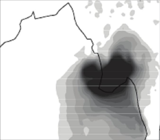
7 The Scientific World Journal 7 25 Latitude (deg.) 15 1 MSLP (hpa) Longitude (deg.) K+NC+N+F B+NC+N+F S+NC+N+F K+NC+N+F B+NC+N+F S+NC+N+F K+Y+N+F B+Y+N+F Maximum wind (kts) K+Y+N+F B+Y+N+F 2 2 K+Y+N+F K+NC+N+F B+Y+N+F B+NC+N+F S+NC+N+F Figure 3: Track, MSLP (hpa), and (c) maximum wind (kts) of the cyclone NARGIS with three best cumulus convections, 2 different PBL, NMM land surface, and Ferrier microphysics option. (c) provided by IMD than the F scheme. However, the intensity predictions with W5, W6, and T schemes are very poorly represented. The minimum MSLP as predicted by S + Y + N + F is 973 hpa, whereas it is 985 hpa, 984 hpa, and 99 hpa withs+y+n+w5,s+y+n+w6,ands+y+ N + T schemes, respectively. Again, the minimum MSLP as predictedbys+y+no+fis976hpa,whereasitis985hpa, 984hPa,and989hPawithS+Y+NO+W5,S+Y+NO+ W6, and S + Y + NO + T schemes, respectively. Hence, it maybeconcludedthatthecombinationsof and S + Y + NO + F are producing better result than any other combination. However, it may be noted that the N land surface scheme is giving slightly better result than the NO scheme in terms of movement and intensity of the storm Precipitation. The results as obtained from the previous subsections clearly show that, the S convection scheme, Y PBL scheme, N and NO land surface schemes, and F microphysics scheme are producing better result than any other combinations. Figure 6 shows 24hrs accumulated precipitation as obtained from Tropical Rainfall Measuring Mission (TRMM 3B42) datasets, which is a merger of TMI, other microwave radiometers (SSMI, AQUA), and IR radiometers calibrated using rain gauges and TRMM s
8 8 The Scientific World Journal 25 Latitude (deg.) Longitude (deg.) B+Y+N+F B+Y+T+F S+Y+T+F B+Y+NO+F S+Y+NO+F B+Y+R+F S+Y+R+F MSLP (hpa) Maximum wind (kts) B+Y+N+F B+Y+T+F S+Y+T+F B+Y+NO+F S+Y+NO+F B+Y+R+F S+Y+R+F B+Y+N+F B+Y+T+F S+Y+T+F B+Y+NO+F S+Y+NO+F B+Y+R+F S+Y+R+F (c) Figure 4: Track, MSLP (hpa), and (c) maximum wind (kts) of the cyclone NARGIS with two best cumulus convections, best PBL, 4 different land surface schemes, and Ferrier microphysics option. precipitation radar and carried out by National Aeronautics and Space Administration (NASA) and model simulations. The precipitation data are obtained from the NASA web site ( The left panel is from TRMM observed precipitation, middle panel is for model simulation with S + Y + N + F combination, and right panel is for S + Y + NO + F combination. The spatial distribution of precipitation is found to be nearly same with both N and NO land surface schemes. However, N scheme is able to produce peak precipitation in terms of both amount and time of occurrence and comparable with observed precipitation than the NO scheme, which has been clearly demonstrated in subsequent section Evaluation of Performance of the Model with Different Initial Conditions. As discussed above (Section 4), the model performance is evaluated with the best two combinations after a detailed investigation of different combinations of convection, PBL, land surface, and microphysics schemes.
9 The Scientific World Journal 9 25 Latitude (deg.) Longitude (deg.) S+Y+N+W5 S+Y+N+W6 S+Y+N+T S+Y+NO+F S+Y+NO+W5 S+Y+NO+W6 S+Y+NO+T MSLP (hpa) Maximum wind (kts) S+Y+N+W5 S+Y+N+W6 S+Y+N+T S+Y+NO+F S+Y+NO+W5 S+Y+NO+W6 S+Y+NO+T S+Y+N+W5 S+Y+N+W6 S+Y+N+T S+Y+NO+F S+Y+NO+W5 S+Y+NO+W6 S+Y+NO+T (c) Figure 5: Track, MSLP (hpa), and (c) maximum wind (kts) of the cyclone NARGIS with best cumulus convections, best PBL, 2 best land surface schemes, and 4 different microphysics options. For this purpose, starting from UTC 28 April 8 and in every 12 hour interval, the model is integrated up to UTC 3 May 8 for each simulation. Thus, another ten experiments (five experiments for each combination) are carried out from the initial condition of 1 UTC 28 April 8, UTC 29 April 8, 1 UTC 29 April 8, UTC 3 April 8, and 1 UTC 3 April Simulation of Track and Intensity. The model simulated track positions, MSLP, and maximum wind along with the IMD observations are presented in Figure 7. Figures 7, 7, and 7(c) are the results as obtained with S convection, Y PBL, F microphysics, and N land surface which shows that the track and intensity is well simulated by the model. Figures 7(d), 7(e), and 7(f) are the results as obtained with S convection, Y PBL, F microphysics, and NO land surface processes. The track simulations with S + Y + N + F and S + Y + NO + F combinations are providing similar types of results. But, a lot of difference is found in intensity prediction. The S + Y + NO + F combination


 3 UTC 3 May 8 3 UTC 3 May")
 3 UTC 1 May 8 3 UTC 3")

 86E 88E 9E 92E 94E 96E 98E E (o)")
, NMM land surface (middle panel),")

10 1 The Scientific World Journal N N N 86E 88E 9E 92E 94E 96E 98E E 86E 88E 9E 92E 94E 96E 98E E N N N 3 UTC 3 April 8 86E 88E 9E 92E 94E 96E 98E E 86E 88E 9E 92E 94E 96E 98E E (d) (e) N N N 86E 88E 9E 92E 94E 96E 98E E 3 UTC 1 May 8 3 UTC 1 May 8 (g) 86E 88E 9E 92E 94E 96E 98E E 86E 88E 9E 92E 94E 96E 98E E (h) (i) N N N 86E 88E 9E 92E 94E 96E 98E E 3 UTC 2 May 8 3 UTC 2 May 8 (j) 86E 88E 9E 92E 94E 96E 98E E 86E 88E 9E 92E 94E 96E 98E E (k) (l) N N N 86E 88E 9E 92E 94E 96E 98E E (m) 3 UTC 3 May 8 3 UTC 3 May 8 86E 88E 9E 92E 94E 96E 98E E (f) 86E 88E 9E 92E 94E 96E 98E E (c) 3 UTC 1 May 8 3 UTC 3 April 8 3 UTC 3 April 8 3 UTC 2 May 8 3 UTC 29 April 8 3 UTC 3 May 8 NOAH NMM 3 UTC 29 April 8 3 UTC 29 April 8 TRMM 86E 88E 9E 92E 94E 96E 98E E (n) 86E 88E 9E 92E 94E 96E 98E E (o) Figure 6: 24 hrs accumulated rainfall from TRMM (left panel), NMM land surface (middle panel), and NOAH land surface (right panel) valid at corresponding time.
11 The Scientific World Journal Latitude (deg.) 15 Latitude (deg.) MSLP (hpa) Maximum wind (kts) Longitude (deg.) 2 IC- IC IC- IC-2 2 IC- IC-2 IC- IC- IC- IC- IC- IC- IC- IC- IC- (c) MSLP (hpa) Maximum wind (kts) Longitude (deg.) IC- IC-2 IC- IC- IC- IC-2 IC- (e) 2 (d) IC- IC- IC- IC- IC- IC- IC-2 IC- (f) Figure 7: Track, MSLP (hpa), and (c) maximum wind (kts) of the cyclone NARGIS with S cumulus convections, Y PBL, NMM land surface scheme, and Ferrier microphysics option at different initial conditions; (d), (e), and (f) are same as,, and (c) but with NOAH land surface scheme.
12 12 The Scientific World Journal UTC 28 April 8 12 UTC 28 April 8 UTC 29 April 8 12 UTC 29 April 8 UTC 3 April 8 12 UTC 3 April 8 TRMM UTC 28 April 8 12 UTC 28 April 8 UTC 29 April 8 UTC 1 May 8 12 UTC 1 May 8 UTC 2 May 8 12 UTC 2 May 8 UTC 3 May 8 12 UTC 3 May 8 UTC 4 May 8 12 UTC 29 April 8 UTC 3 April 8 12 UTC 3 April 8 UTC 28 April 8 12 UTC 28 April 8 UTC 29 April 8 12 UTC 29 April 8 UTC 3 April 8 12 UTC 3 April 8 TRMM UTC 28 April 8 12 UTC 28 April 8 UTC 29 April 8 UTC 1 May 8 12 UTC 1 May 8 UTC 2 May 8 12 UTC 2 May 8 UTC 3 May 8 12 UTC 3 May 8 UTC 4 May 8 12 UTC 29 April 8 UTC 3 April 8 12 UTC 3 April 8 Figure 8: Time-series of area-averaged rainfall (cm hr 1 ) from TRMM and model simulation at different initial conditions. Comparison among TRMM and model simulation with NMM land surface scheme and same as but with NOAH land surface scheme. Table 2: Mean absolute track errors (km) with two optimum physics combinations with different initial conditions. Initial conditions Land surface hr 12 hrs 24 hrs 36 hrs 48 hrs 6 hr 72 hrs 84 hrs 96 hrs 1 UTC 28 Apr UTC 29 Apr UTC 29 Apr 8 NMM UTC 3 Apr UTC 3 Apr Mean error UTC 28 Apr UTC 29 Apr UTC 29 Apr 8 NOAH UTC 3 Apr UTC 3 Apr Mean error % of improvement produces the less intensity prediction and also results in 3 hrs delay in time. Themeanabsolutetrackerror(MATE)(km)withthe two optimum physics combinations with different initial conditions are evaluated up to 96 hrs of simulation. The mean MATEs are also calculated for the same period. The 24 hrs result shows that there is an improvement of 3.6% withcombinationthans+y+no+f options. Similarly, 48, 72, and 96 hrs results clearly show an improvement of 13.5%, 49%, and 3%, respectively, with the S + Y + N + F combination than S + Y + NO + F options. The detailes of the MATEs are presented in Table 2. The landfall point errors (LEs) and landfall time errors are also calculated with the two optimum physics combinations with different initial conditions. Results show that S + Y + N + F combination is giving less landfall point error than the S + Y + NO + F combination, though the landfall time error is same in both the schemes. The detailes of the LEs are presented in Table Simulation of Precipitation Pattern. Figures 8 and 8 demonstrated the time series of area averaged precipitation simulation with S + Y + N + F and S + Y + NO + F
13 The Scientific World Journal UTC 28 April 8 12 UTC 28 April 8 UTC 29 April 8 12 UTC 29 April 8 UTC 3 April 8 12 UTC 3 April 8 UTC 1 May 8 12 UTC 1 May 8 UTC 2 May 8 12 UTC 2 May 8 UTC 3 May 8 12 UTC 3 May 8 UTC 4 May 8 UTC 28 April 8 12 UTC 28 April 8 UTC 29 April 8 12 UTC 29 April 8 UTC 3 April 8 12 UTC 3 April 8 UTC 1 May 8 12 UTC 1 May 8 UTC 2 May 8 12 UTC 2 May 8 UTC 3 May 8 12 UTC 3 May 8 UTC 4 May 8 UTC 28 April 8 12 UTC 28 April 8 UTC 29 April 8 12 UTC 29 April 8 UTC 3 April 8 12 UTC 3 April 8 UTC 28 April 8 12 UTC 28 April 8 UTC 29 April 8 12 UTC 29 April 8 UTC 3 April 8 12 UTC 3 April 8 UTC 28 April 8 12 UTC 28 April 8 UTC 29 April 8 12 UTC 29 April 8 UTC 3 April 8 12 UTC 3 April 8 UTC 28 April 8 12 UTC 28 April 8 UTC 29 April 8 (c) UTC 1 May 8 12 UTC 1 May 8 UTC 2 May 8 12 UTC 2 May 8 UTC 3 May 8 12 UTC 3 May 8 12 UTC 29 April 8 UTC 3 April 8 12 UTC 3 April 8 UTC 4 May 8 Figure 9: Time series of model-simulated ground heat flux (Wm 2 ), latent heat flux (Wm 2 ), and (c) sensible heat flux (Wm 2 )at different initial conditions with NMM land surface scheme. Table 3: Landfall point errors (km) and landfall time errors (hrs) with two optimum physics combination at different initial conditions. Landfall point error (km) with different land surface Landfall time error (hrs) with different land surface Initial conditions NMM NOAH NMM NOAH UTC 28 Apr UTC 28 Apr UTC 29 Apr UTC 29 Apr UTC 3 Apr UTC 3 Apr
14 14 The Scientific World Journal UTC 28 April 8 12 UTC 28 April 8 UTC 29 April 8 12 UTC 29 April 8 UTC 3 April 8 12 UTC 3 April 8 UTC 1 May 8 12 UTC 1 May 8 UTC 2 May 8 12 UTC 2 May 8 UTC 3 May 8 12 UTC 3 May 8 UTC 4 May 8 UTC 28 April 8 12 UTC 28 April 8 UTC 29 April 8 12 UTC 29 April 8 UTC 3 April 8 12 UTC 3 April 8 UTC 1 May 8 12 UTC 1 May 8 UTC 2 May 8 12 UTC 2 May 8 UTC 3 May 8 12 UTC 3 May 8 UTC 4 May 8 UTC 28 April 8 12 UTC 28 April 8 UTC 29 April 8 12 UTC 29 April 8 UTC 3 April 8 12 UTC 3 April 8 UTC 28 April 8 12 UTC 28 April 8 UTC 29 April 8 12 UTC 29 April 8 UTC 3 April 8 12 UTC 3 April 8 UTC 28 April 8 12 UTC 28 April 8 UTC 29 April 8 12 UTC 29 April 8 UTC 3 April 8 12 UTC 3 April 8 UTC 1 May 8 12 UTC 1 May 8 UTC 2 May 8 12 UTC 2 May 8 UTC 3 May 8 12 UTC 3 May 8 UTC 4 May 8 UTC 28 April 8 12 UTC 28 April 8 UTC 29 April 8 12 UTC 29 April 8 UTC 3 April 8 12 UTC 3 April 8 (c) Figure 1: Time series of model simulated ground heat flux (Wm 2 ), latent heat flux (Wm 2 ) and (c) sensible heat flux (Wm 2 )at different initial conditions with NOAH land surface scheme. combinations, respectively. For the both combinations, the model is integrated at different initial conditions as described above. Also, the time series of area-averaged TRMM precipitation is considered for better comparison. A lot of improvement is seen with N scheme than the NO scheme. Two peak intensities are found from TRMM precipitation at UTC 1 May 8 and UTC 2 May 8. The model with N scheme is able to simulate the peak precipitation than the NO scheme. At UTC 1 May 8, TRMM produced the averaged precipitation of 4.6 mm and model could simulate the precipitation of 3.7 mm and 2.4 mm with N and NO schemes, respectively. Similarly, at UTC 2 May 8, TRMM produced averaged precipitation of 4.1 mm and model could simulate the precipitation of 3.9 mm and 2.9 mm with N and NO schemes, respectively. Hence, it may be concluded that the N scheme well-simulates the precipitation than the NO scheme Some Characteristic Features of Nargis. It has been attempted to study the structure of Nargis in terms of simulation of heat fluxes, vertical velocity, and absolute vorticity
 UTC 3 April 8 12 UTC 28 April 8 (d) 12 UTC 29 April 8 2 1.5.5 1.")
 12 UTC 3 April 8 Figure 11: Model-simulated vertical velocity (ms")

, latent heat fluxes (LHF-), and sensible heat fluxes (SHF-) with N")
 represent the model-simulated ground heat fluxes,")

15 The Scientific World Journal 15 UTC 28 April 8 (c) UTC 29 April (e) UTC 3 April 8 12 UTC 28 April 8 (d) 12 UTC 29 April (f) 12 UTC 3 April 8 Figure 11: Model-simulated vertical velocity (ms 1 ) at the peak intense time with different initial conditions with NMM land surface scheme. at different initial conditions. Figures 9, 9, and 9(c) represent the model-simulated ground heat fluxes (GHF-), latent heat fluxes (LHF-), and sensible heat fluxes (SHF-) with N scheme and with different initial conditions. Figures 1, 1, and 1(c) represent the model-simulated ground heat fluxes, latent heat fluxes, and sensible heat fluxes with NO scheme and with different initial conditions. The latent heat flux is one of the dominant components of the air-sea energy exchange processes associated with tropical cyclones. The model simulation with N scheme produced the
 UTC 29 April 8 12 UTC 28 April 8 93E 93.5E 94E 94.")
 12 UTC 29 April 8 4 6 8 1 14 (e) UTC 3 April 8 4 6 8 1 14 (f) 12")


16 16 The Scientific World Journal UTC 28 April 8 93E 93.5E 94E 94.5E 95E 95.5E 96E 96.5E 97E (c) UTC 29 April 8 12 UTC 28 April 8 93E 93.5E 94E 94.5E 95E 95.5E 96E 96.5E 97E (d) 12 UTC 29 April (e) UTC 3 April (f) 12 UTC 3 April 8 Figure 12: Model-simulated absolute vorticity ( 1 5 s 1 ) at the peak intense time with different initial conditions with NMM land surface scheme. LHF of 1 Wm 2, whereas the simulation with NO scheme produced the LHF of Wm 2. Furthermore, the vertical structure of the storm has been demonstrated with the optimum combination, that is, with S convection, Y planetary boundary layer, N land surface, and F microphysics scheme. Figure 11 represents the modelsimulated vertical velocity at the peak intense time of the system with different initial conditions. The strong updraft and downdraft are noticed from model simulation. The maximum value of 5 ms 1 is seen in the middle level and
17 The Scientific World Journal 17 updraft is extended up to 15hPa.Figure 12 represents the model-simulated absolute vorticity at the peak intense time with different initial conditions. The positive vorticity of order of S 1 is extended up to hpa. Also, strong positive vorticity is found up to hpa. All the above results and discussions clearly demonstrate that the S + Y + N + F combination is the optimum combination among all the other combinations in terms of predicting track, intensity, precipitation, and structure of the storm. 6. Conclusions From the present study on the impact of parameterization schemes for simulation of tropical cyclone, the following broad conclusions are drawn. The model is sensitive to cumulus convection, planetary boundary layer, and microphysics parameterization schemes. The results from sensitivity experiments with different schemes for cumulus convection indicate that the movement of the cyclone is quite sensitive to the convection processes. The Simplified Arakawa Schubert convection scheme gives better track positions with minimum vector displacement and landfall errors. The result has been clearly demonstrated from the simulation of inner core structure of the storm through temperature anomaly and horizontal wind pattern. The results from sensitivity experiments with different PBL schemes indicate that the PBL plays an important role in the intensification of the storm. The NCEP GFS scheme gives early intensification of the storm. However, YSU scheme well-simulated the intensification of the storm which is more comparable with the observed value and intense period of the storm. Also, track is well simulated with YSU scheme. The results from different experiments with land surface physics schemes show that the NMM and NOAH land surface schemes are producing similar type of results and performing well than any other schemes. However, the NMM scheme is giving better result in terms of track and intensity prediction of the storm than the NOAH scheme. Similarly, the results from sensitivity experiments with different microphysics schemes show that the Ferrier scheme is providing better result in terms of track and intensity prediction than other schemes considered in this study. Further, the results on optimum suitable combination of physical processes in WRF-NMM system are confirmed with additional five different initial values as illustrated in this study. The mean vector displacement error at 24, 48, 72, and 96 hrs are improved by 3%, 13%, 49%, and 3%, respectively, with the optimum combination. The time of occurrence of maximum rainfalls is well captured. Also, the structure of the storm is well predicted with the optimum combination. The results indicate that the combination of Simplified Arakawa Schubert for cumulus convection, Yonsei University planetary boundary layer, NMM land surface, and Ferrier microphysics schemes are providing better result in terms of simulation of track, intensity, and structure of the cyclone than other combinations considered in this study. Acknowledgments The Indian National Center for Ocean Information Services (INCOIS) is acknowledged for affording financially under INDOMOD project for this research. The authors gratefully acknowledge the NCEP for providing the NMM model and real-time large-scale analysis as well as forecasts of Global Forecast System (GFS). The authors acknowledge the India Meteorological Department (IMD) for providing observational datasets for intensity and best-fit track data of the storm. References [1] D. V. Bhaskar Rao, C. V. Naidu, and B. R. Srinivasa Rao, Trends and fluctuations of the cyclonic systems over North Indian Ocean, Mausam, vol. 52, pp , 1. [2] D. De Angelis, World of tropical cyclones North Indian Ocean, Marines Weather Log, vol., pp , [3] R.A.Anthes,Tropical Cyclones: Their Evolution, Structure and Effects, Meteorological Monographs, American Meteorological Society, Boston, Mass, USA, 41 edition, [4] W. M. Frank, The cumulus parameterization problem, Monthly Weather Review, vol. 111, pp , [5] J. Molinari and M. Dudek, Parameterization of convective precipitation in mesoscale numerical models: a critical review, Monthly Weather Review, vol. 1, no. 2, pp , [6] R. A. Anthes, A cumulus parameterization scheme utilizing a one-dimensional cloud model, Monthly Weather Review, vol. 15, no. 3, pp , [7] M. Mandal, U. C. Mohanty, and S. Raman, A study on the parameterization of physical processes on prediction of tropical cyclones over the Bay of Bengal with NCAR/PSU mesoscale model, Natural Hazards, vol. 31, no. 2, pp , 4. [8] D. V. Bhaskar Rao and D. Hari Prasad, Sensitivity of tropical cyclone intensification to boundary layer and convective processes, Natural Hazards, vol. 41, no. 3, pp , 7. [9] S. A. Braun and W.-K. Tao, Sensitivity of high resolution simulation of hurricane Bob (1991) to planetary boundary layer parameterizations, Monthly Weather Review, vol. 128, no. 12, pp ,. [1] Krishna K. Osuri, U. C. Mohanty, A. Routray, M. A. Kulkarni, and M. Mohapatra, Customization of WRF-ARW model with physical parameterization schemes for the simulation of tropical cyclones over North Indian Ocean, Natural Hazard. In press. [11] Z. I. Janjic, Nonsingular Implementation of the Mellor- Yamada level 2.5 scheme in the NCEP mesoscale model, National Centers for Environmental Prediction Office Note, vol. 437, p. 61, 1. [12] Z. I. Janjic, A Non-hydrostatic model based on a new approach, Meteorology and Atmospheric Physics, vol. 82, no. 1 4, pp , 3. [13] Z. I. Janjic, The NCEP WRF core and further development of its physical package, in Proceedings of the 5th International SRNWP Workshop on Non-Hydrostatic Modeling, BadOrb, Germany, October, 3. [14] Z. I. Janjic, Non-linear advection schemes and energy cascade on semi-staggered grids, Monthly Weather Review, vol., no. 6, pp , 1984.
18 18 The Scientific World Journal [15] S.-Y. Hong and H.-L. Pan, Non-local boundary layer vertical diffusion in a medium range forecast model, Monthly Weather Review, vol. 124, no. 1, pp , [16] I. Troen and L. Mahrt, A simple model of the atmospheric boundary layer: sensitivity to surface evaporation, Boundary Layer Meteorology, vol. 37, no. 1-2, pp , [17] A. Arakawa and W. H. Schubert, Interaction of a cumulus cloud ensemble with the large scale environment, Journal of Atmospheric Science, vol. 31, no. 3, pp , [18] G. A. Grell, Prognostic evaluation of assumption used by cumulus parameterization, Monthly Weather Review, vol. 121, no. 3, pp , [19] H.-L. Pan and W.-S. Wu, Implementing a mass flux convection parameterization package for the NMC medium-range forecast model, NMC Office Note 49, National Centers For Environmental Prediction, Environmental Modeling Center, Washington, DC, USA, [] J. S. Kain, The Kain-Fritsch convective parameterization: an update, Journal of Applied Meteorology, vol. 43, no. 1, pp , 4. [21] J. S. Kain and J. M. Fritsch, Convective parameterization for mesoscale models: the Kain-Fritsch scheme, in The Representation of Cumulus Convection in Numerical Models, K. A. Emanuel and D. J. Raymond, Eds., p. 246, American Meteorological Society, [22] A. K. Betts and M. J. Miller, A new convective adjustment scheme. Part II: single column tests using GATE wave, BOMEX, ATEX, and Arctic air-mass data sets, Quarterly Journal of Royal Meteorological Society, vol., no. 473, pp , [23] Z. I. Janjic, The step-mountain eta coordinate model: further developments of the convection, viscous sub-layer and turbulence closure schemes, Monthly Weather Review, vol. 122, no. 5, pp , [24] J. S. Kain and J. M. Fritsch, A one-dimensional Entraining/Detraining plume model and its application in convective parameterization, Journal of Atmospheric Science, vol. 47, no. 23, pp , 199. [25] Z. I. Janjic, Comments on development and evaluation of a convection scheme for use in climate models, Journal of Atmospheric Science, vol. 57, no. 21, pp ,. [26] G. A. Grell and D. Dévényi, A generalized approach to parameterizing convection combining ensemble and data assimilation techniques, Geophysical Research Letter, vol. 29, no. 14, pp , 2. [27] W. C. Skamaraock, J. B. Klemp, J. Dudhia et al., A description of the Advanced Research WRF Version 2, NCAR Technical Note, 5. [28] M. B. Ek, K. E. Mitchell, Y. Lin et al., Implementation of NOAH land surface model advances in the NCEP operational mesoscale Eta model, Journal of Geophysical Research, vol. 18, no. D22, p. 8851, 3. [29] F. Chen and J. Dudhia, Coupling an advanced land-surface/ hydrology model with the Penn State/NCAR MM5 modeling system. Part I: model description and implementation, Monthly Weather Review, vol. 129, no. 4, pp , 1. [3]T.G.Smirnova,J.M.Brown,S.G.Benjaminetal., Performance of different soil model configurations in simulating ground surface temperature and surface fluxes, Monthly Weather Review, vol. 125, no. 8, pp , [31]T.G.Smirnova,J.M.Brown,S.G.Benjamin,andD.Kim, Parameterization of cold season processes in the MAPS landsurface scheme, Journal of Geophysical Research, vol. 15, no. D3, pp ,. [32] B. S. Ferrier, Y. Lin, T. Black, E. Rogers, and G. DiMego, Implementation of a new grid-scale cloud and precipitation scheme in the NCEP Eta model, in Proceedings of the 15th Conference on Numerical Weather Prediction, pp , American Meteorological Society, San Antonio, Tex, USA, 2. [33] S.-Y. Hong, H.-M. H. Juang, and Q. Zhao, Implementation of prognostic cloud scheme for a regional spectral model, Monthly Weather Review, vol. 126, no. 1, pp , [34] S.-Y. Hong, J. Dudhia, and S.-H. Chen, A Revised approach to ice microphysical processes for the bulk parameterization of clouds and precipitation, Monthly Weather Review, vol. 132, no. 1, pp. 13 1, 4. [35] Y.-L. Lin, R. D. Farley, and H. D. Orville, Bulk parameterization of the snow field in a cloud model, Journal of Climate and Applied Meteorology, vol. 22, no. 6, pp , [36] J. Dudhia, Numerical study of convection observed during the winter monsoon experiment using a mesoscale twodimensional model, Journal of Atmospheric Science, vol. 46, no., pp , [37] G. Thompson, R. M. Rasmussen, and K. Manning, Explicit forecasts of winter precipitation using an improved bulk microphysics scheme, Part I: description and sensitivity analysis, Monthly Weather Review, vol. 132, no. 2, pp , 4.


19 Journal of International Journal of Ecology Journal of Geochemistry Mining The Scientific World Journal Scientifica Journal of Earthquakes Paleontology Journal Journal of Petroleum Engineering Submit your manuscripts at Geophysics International Journal of Advances in Journal of Mineralogy Geological Research Advances in Geology Climatology International Journal of Advances in Journal of Meteorology International Journal of Atmospheric Sciences International Journal of Oceanography Oceanography Applied & Environmental Soil Science Journal of Computational Environmental Sciences
A comparative study on performance of MM5 and WRF models in simulation of tropical cyclones over Indian seas
 A comparative study on performance of MM5 and WRF models in simulation of tropical cyclones over Indian seas Sujata Pattanayak and U. C. Mohanty* Centre for Atmospheric Sciences, Indian Institute of Technology
NUMERICAL SIMULATION OF A BAY OF BENGAL TROPICAL CYCLONE: A COMPARISON OF THE RESULTS FROM EXPERIMENTS WITH JRA-25 AND NCEP REANALYSIS FIELDS
 NUMERICAL SIMULATION OF A BAY OF BENGAL TROPICAL CYCLONE: A COMPARISON OF THE RESULTS FROM EXPERIMENTS WITH JRA-25 AND NCEP REANALYSIS FIELDS Dodla Venkata Bhaskar Rao Desamsetti Srinivas and Dasari Hari
The Fifth-Generation NCAR / Penn State Mesoscale Model (MM5) Mark Decker Feiqin Xie ATMO 595E November 23, 2004 Department of Atmospheric Science
 Mark Decker Feiqin Xie ATMO 595E November 23, 2004 Department of Atmospheric Science") The Fifth-Generation NCAR / Penn State Mesoscale Model (MM5) Mark Decker Feiqin Xie ATMO 595E November 23, 2004 Department of Atmospheric Science Outline Basic Dynamical Equations Numerical Methods Initialization
The Fifth-Generation NCAR / Penn State Mesoscale Model (MM5) Mark Decker Feiqin Xie ATMO 595E November 23, 2004 Department of Atmospheric Science Outline Basic Dynamical Equations Numerical Methods Initialization
A Study of Convective Initiation Failure on 22 Oct 2004
 A Study of Convective Initiation Failure on 22 Oct 2004 Jennifer M. Laflin Philip N. Schumacher NWS Sioux Falls, SD August 6 th, 2011 Introduction Forecasting challenge: strong forcing for ascent and large
Weather Research and Forecasting Model. Melissa Goering Glen Sampson ATMO 595E November 18, 2004
 Weather Research and Forecasting Model Melissa Goering Glen Sampson ATMO 595E November 18, 2004 Outline What does WRF model do? WRF Standard Initialization WRF Dynamics Conservation Equations Grid staggering
Sensitivity of tropical cyclone Jal simulations to physics parameterizations
 Sensitivity of tropical cyclone Jal simulations to physics parameterizations R Chandrasekar and C Balaji Department of Mechanical Engineering, Indian Institute of Technology, Madras, Chennai 6 36, India.
Impact of different cumulus parameterizations on the numerical simulation of rain over southern China
 Impact of different cumulus parameterizations on the numerical simulation of rain over southern China P.W. Chan * Hong Kong Observatory, Hong Kong, China 1. INTRODUCTION Convective rain occurs over southern
MESOSCALE DATA ASSIMILATION FOR SIMULATION OF HEAVY RAINFALL EVENTS ASSOCIATED WITH SOUTH-WEST MONSOON
 MESOSCALE DATA ASSIMILATION FOR SIMULATION OF HEAVY RAINFALL EVENTS ASSOCIATED WITH SOUTH-WEST MONSOON ASHISH ROUTRAY CENTRE FOR ATMOSPHERIC SCIENCES INDIAN INSTITUTE OF TECHNOLOGY, DELHI HAUZ KHAS, NEW
Department of Meteorology, University of Utah, Salt Lake City, UT. Second revision. Submitted to Monthly Weather Review.
 Sensitivity of Numerical Simulation of Early Rapid Intensification of Hurricane Emily (2005) to Cloud Microphysical and Planetary Boundary Layer Parameterizations XUANLI LI and ZHAOXIA PU * Department
Research Article Numerical Simulations and Analysis of June 16, 2010 Heavy Rainfall Event over Singapore Using the WRFV3 Model
 International Atmospheric Sciences Volume 2013, Article ID 825395, 8 pages http://dx.doi.org/.1155/2013/825395 Research Article Numerical Simulations and Analysis of June 16, 20 Heavy Rainfall Event over
608 SENSITIVITY OF TYPHOON PARMA TO VARIOUS WRF MODEL CONFIGURATIONS
 608 SENSITIVITY OF TYPHOON PARMA TO VARIOUS WRF MODEL CONFIGURATIONS Phillip L. Spencer * and Brent L. Shaw Weather Decision Technologies, Norman, OK, USA Bonifacio G. Pajuelas Philippine Atmospheric,
Sensitivity of precipitation forecasts to cumulus parameterizations in Catalonia (NE Spain)
") Sensitivity of precipitation forecasts to cumulus parameterizations in Catalonia (NE Spain) Jordi Mercader (1), Bernat Codina (1), Abdelmalik Sairouni (2), Jordi Cunillera (2) (1) Dept. of Astronomy and
Sensitivity of precipitation forecasts to cumulus parameterizations in Catalonia (NE Spain) Jordi Mercader (1), Bernat Codina (1), Abdelmalik Sairouni (2), Jordi Cunillera (2) (1) Dept. of Astronomy and
Atmospheric Motion Vectors (AMVs) and their forecasting significance
 and their forecasting significance") Atmospheric Motion Vectors (AMVs) and their forecasting significance Vijay Garg M.M. College, Modi Nagar, Ghaziabad, Uttar Pradesh R.K. Giri Meteorological Center India Meteorological Department, Patna-14
Atmospheric Motion Vectors (AMVs) and their forecasting significance Vijay Garg M.M. College, Modi Nagar, Ghaziabad, Uttar Pradesh R.K. Giri Meteorological Center India Meteorological Department, Patna-14
Analysis on MM5 predictions at Sriharikota during northeast monsoon 2008
 Analysis on MM5 predictions at Sriharikota during northeast monsoon 8 D Gayatri Vani, S Rambabu, M Rajasekhar, GVRama, B V Apparao and A K Ghosh MET-Facility, Satish Dhawan Space Centre, SHAR, ISRO, Sriharikota
MEA 716 Exercise, BMJ CP Scheme With acknowledgements to B. Rozumalski, M. Baldwin, and J. Kain Optional Review Assignment, distributed Th 2/18/2016
 MEA 716 Exercise, BMJ CP Scheme With acknowledgements to B. Rozumalski, M. Baldwin, and J. Kain Optional Review Assignment, distributed Th 2/18/2016 We have reviewed the reasons why NWP models need to
P Hurricane Danielle Tropical Cyclogenesis Forecasting Study Using the NCAR Advanced Research WRF Model
 P1.2 2004 Hurricane Danielle Tropical Cyclogenesis Forecasting Study Using the NCAR Advanced Research WRF Model Nelsie A. Ramos* and Gregory Jenkins Howard University, Washington, DC 1. INTRODUCTION Presently,
SIMULATION OF ATMOSPHERIC STATES FOR THE CASE OF YEONG-GWANG STORM SURGE ON 31 MARCH 2007 : MODEL COMPARISON BETWEEN MM5, WRF AND COAMPS
 SIMULATION OF ATMOSPHERIC STATES FOR THE CASE OF YEONG-GWANG STORM SURGE ON 31 MARCH 2007 : MODEL COMPARISON BETWEEN MM5, WRF AND COAMPS JEONG-WOOK LEE 1 ; KYUNG-JA HA 1* ; KI-YOUNG HEO 1 ; KWANG-SOON
American International Journal of Research in Science, Technology, Engineering & Mathematics
 Amican Intnational Journal of Research in Science, Technology, Engineing & Mathematics Available online at http://www.iasir.net ISSN (Print): 2328-3491, ISSN (Online): 2328-3580, ISSN (CD-ROM): 2328-3629
Precipitation Structure and Processes of Typhoon Nari (2001): A Modeling Propsective
: A Modeling Propsective") Precipitation Structure and Processes of Typhoon Nari (2001): A Modeling Propsective Ming-Jen Yang Institute of Hydrological Sciences, National Central University 1. Introduction Typhoon Nari (2001) struck
Precipitation Structure and Processes of Typhoon Nari (2001): A Modeling Propsective Ming-Jen Yang Institute of Hydrological Sciences, National Central University 1. Introduction Typhoon Nari (2001) struck
THE INFLUENCE OF HIGHLY RESOLVED SEA SURFACE TEMPERATURES ON METEOROLOGICAL SIMULATIONS OFF THE SOUTHEAST US COAST
 THE INFLUENCE OF HIGHLY RESOLVED SEA SURFACE TEMPERATURES ON METEOROLOGICAL SIMULATIONS OFF THE SOUTHEAST US COAST Peter Childs, Sethu Raman, and Ryan Boyles State Climate Office of North Carolina and
Impact of cloud parameterization schemes on the simulation of cyclone Vardah using the WRF model
 Impact of cloud parameterization schemes on the simulation of cyclone Vardah using the WRF model C. P. R. Sandeep, C. Krishnamoorthy and C. Balaji* Department of Mechanical Engineering, Indian Institute
Regional Scale Modeling and Numerical Weather Prediction
 Regional Scale Modeling and Numerical Weather Prediction Jimy Dudhia NCAR/MMM Mesoscale & Microscale Meteorological Division / NCAR Overview of talk WRF Modeling System Overview WRF Model Dynamics Physics
Kelly Mahoney NOAA ESRL Physical Sciences Division
 The role of gray zone convective model physics in highresolution simulations of the 2013 Colorado Front Range Flood WRF model simulated precipitation over terrain in CO Front Range Kelly Mahoney NOAA ESRL
Improved rainfall and cloud-radiation interaction with Betts-Miller-Janjic cumulus scheme in the tropics
 Improved rainfall and cloud-radiation interaction with Betts-Miller-Janjic cumulus scheme in the tropics Tieh-Yong KOH 1 and Ricardo M. FONSECA 2 1 Singapore University of Social Sciences, Singapore 2
UNIVERSITY OF CALIFORNIA
 UNIVERSITY OF CALIFORNIA Methods of Improving Methane Emission Estimates in California Using Mesoscale and Particle Dispersion Modeling Alex Turner GCEP SURE Fellow Marc L. Fischer Lawrence Berkeley National
Available online at ScienceDirect. Procedia Engineering 116 (2015 )
") Available online at www.sciencedirect.com ScienceDirect Procedia Engineering 116 (2015 ) 655 662 8th International Conference on Asian and Pacific Coasts (APAC 2015) Department of Ocean Engineering, IIT
Available online at www.sciencedirect.com ScienceDirect Procedia Engineering 116 (2015 ) 655 662 8th International Conference on Asian and Pacific Coasts (APAC 2015) Department of Ocean Engineering, IIT
A New Ocean Mixed-Layer Model Coupled into WRF
 ATMOSPHERIC AND OCEANIC SCIENCE LETTERS, 2012, VOL. 5, NO. 3, 170 175 A New Ocean Mixed-Layer Model Coupled into WRF WANG Zi-Qian 1,2 and DUAN An-Min 1 1 The State Key Laboratory of Numerical Modeling
Tropical cyclone predictions over the Bay of Bengal using the high-resolution Advanced Research Weather Research and Forecasting (ARW) model
 model") Quarterly Journal of the Royal Meteorological Society Q. J. R. Meteorol. Soc. 139: 1810 1825, October 2013 A Tropical cyclone predictions over the Bay of Bengal using the high-resolution Advanced Research
Quarterly Journal of the Royal Meteorological Society Q. J. R. Meteorol. Soc. 139: 1810 1825, October 2013 A Tropical cyclone predictions over the Bay of Bengal using the high-resolution Advanced Research
Simulating roll clouds associated with low-level convergence in WRF
 Simulating roll clouds associated with low-level convergence in WRF Abhnil Prasad1,3, Steven Sherwood1,3 and Hélène Brogniez2 1 Climate Change Research Centre, University of New South Wales, Sydney, NSW,
Evaluation of High-Resolution WRF Model Simulations of Surface Wind over the West Coast of India
 ATMOSPHERIC AND OCEANIC SCIENCE LETTERS, 2014, VOL. 7, NO. 5, 458 463 Evaluation of High-Resolution WRF Model Simulations of Surface Wind over the West Coast of India S. VISHNU and P. A. FRANCIS Indian
QUANTITATIVE VERIFICATION STATISTICS OF WRF PREDICTIONS OVER THE MEDITERRANEAN REGION
 QUANTITATIVE VERIFICATION STATISTICS OF WRF PREDICTIONS OVER THE MEDITERRANEAN REGION Katsafados P. 1, Papadopoulos A. 2, Mavromatidis E. 1 and Gikas N. 1 1 Department of Geography, Harokopio University
CORDEX Simulations for South Asia
 WCRP CORDEX South Asia Planning Meeting 25-26 February 2012 Indian Institute of Tropical Meteorology (IITM) Pune, India CORDEX Simulations for South Asia J. Sanjay Centre for Climate Change Research (CCCR)
Convective scheme and resolution impacts on seasonal precipitation forecasts
 GEOPHYSICAL RESEARCH LETTERS, VOL. 30, NO. 20, 2078, doi:10.1029/2003gl018297, 2003 Convective scheme and resolution impacts on seasonal precipitation forecasts D. W. Shin, T. E. LaRow, and S. Cocke Center
P1.2 SENSITIVITY OF WRF MODEL FORECASTS TO DIFFERENT PHYSICAL PARAMETERIZATIONS IN THE BEAUFORT SEA REGION
 P1.2 SENSITIVITY OF WRF MODEL FORECASTS TO DIFFERENT PHYSICAL PARAMETERIZATIONS IN THE BEAUFORT SEA REGION Jeremy R. Krieger *, Jing Zhang Arctic Region Supercomputing Center, University of Alaska Fairbanks
The sensitivity to the microphysical schemes on the skill of forecasting the track and intensity of tropical cyclones using WRF-ARW model
 J. Earth Syst. Sci. (2017) 126:57 c Indian Academy of Sciences DOI 10.1007/s12040-017-0830-2 The sensitivity to the microphysical schemes on the skill of forecasting the track and intensity of tropical
Variable-Resoluiton Global Atmospheric Modeling Spanning Convective to Planetary Scales
 Variable-Resoluiton Global Atmospheric Modeling Spanning Convective to Planetary Scales Bill Skamarock, NCAR/MMM MPAS consists of geophysical fluid-flow solvers based on unstructured centroidal Voronoi
WRF Model Simulated Proxy Datasets Used for GOES-R Research Activities
 WRF Model Simulated Proxy Datasets Used for GOES-R Research Activities Jason Otkin Cooperative Institute for Meteorological Satellite Studies Space Science and Engineering Center University of Wisconsin
Xuanli LI and Zhaoxia PU. Department of Atmospheric Sciences, University of Utah, Salt Lake City, Utah, USA
 Journal of the Meteorological Society of Japan, Vol. 87, No. 3, pp. 403--421, 2009. 403 DOI:10.2151/jmsj.87.403 Sensitivity of Numerical Simulations of the Early Rapid Intensification of Hurricane Emily
Impact of GPS RO Data on the Prediction of Tropical Cyclones
 Impact of GPS RO Data on the Prediction of Tropical Cyclones Ying-Hwa Kuo, Hui Liu, UCAR Ching-Yuang Huang, Shu-Ya Chen, NCU Ling-Feng Hsiao, Ming-En Shieh, Yu-Chun Chen, TTFRI Outline Tropical cyclone
Meteorological Modeling using Penn State/NCAR 5 th Generation Mesoscale Model (MM5)
") TSD-1a Meteorological Modeling using Penn State/NCAR 5 th Generation Mesoscale Model (MM5) Bureau of Air Quality Analysis and Research Division of Air Resources New York State Department of Environmental
TSD-1a Meteorological Modeling using Penn State/NCAR 5 th Generation Mesoscale Model (MM5) Bureau of Air Quality Analysis and Research Division of Air Resources New York State Department of Environmental
Comparison of Convection-permitting and Convection-parameterizing Ensembles
 Comparison of Convection-permitting and Convection-parameterizing Ensembles Adam J. Clark NOAA/NSSL 18 August 2010 DTC Ensemble Testbed (DET) Workshop Introduction/Motivation CAMs could lead to big improvements
Incorporation of 3D Shortwave Radiative Effects within the Weather Research and Forecasting Model
 Incorporation of 3D Shortwave Radiative Effects within the Weather Research and Forecasting Model W. O Hirok and P. Ricchiazzi Institute for Computational Earth System Science University of California
School of Atmospheric Sciences, Sun Yat-sen University, Guangzhou , China 2
 1 2 3 4 5 6 7 8 9 10 Article Sensitivity of Different Parameterizations on Simulation of Tropical Cyclone Durian over the South China Sea using Weather Research and Forecasting (WRF) model Worachat Wannawong
A comparative study on the genesis of North Indian Ocean cyclone Madi (2013) and Atlantic Ocean cyclone Florence (2006)
 and Atlantic Ocean cyclone Florence (2006)") A comparative study on the genesis of North Indian Ocean cyclone Madi (2013) and Atlantic Ocean cyclone Florence (2006) VPM Rajasree 1, Amit P Kesarkar 1, Jyoti N Bhate 1, U Umakanth 1 Vikas Singh 1 and
A comparative study on the genesis of North Indian Ocean cyclone Madi (2013) and Atlantic Ocean cyclone Florence (2006) VPM Rajasree 1, Amit P Kesarkar 1, Jyoti N Bhate 1, U Umakanth 1 Vikas Singh 1 and
Lightning Data Assimilation using an Ensemble Kalman Filter
 Lightning Data Assimilation using an Ensemble Kalman Filter G.J. Hakim, P. Regulski, Clifford Mass and R. Torn University of Washington, Department of Atmospheric Sciences Seattle, United States 1. INTRODUCTION
P1M.4 COUPLED ATMOSPHERE, LAND-SURFACE, HYDROLOGY, OCEAN-WAVE, AND OCEAN-CURRENT MODELS FOR MESOSCALE WATER AND ENERGY CIRCULATIONS
 P1M.4 COUPLED ATMOSPHERE, LAND-SURFACE, HYDROLOGY, OCEAN-WAVE, AND OCEAN-CURRENT MODELS FOR MESOSCALE WATER AND ENERGY CIRCULATIONS Haruyasu NAGAI *, Takuya KOBAYASHI, Katsunori TSUDUKI, and Kyeongok KIM
HWRF sensitivity to cumulus schemes
 HWRF sensitivity to cumulus schemes Mrinal K Biswas and Ligia R Bernardet HFIP Telecon, 01 February 2012 Motivation HFIP Regional Model Team Physics Workshop (Aug 11): Foci: Scientific issues on PBL and
SIMULATION OF ARCTIC STORMS 7B.3. Zhenxia Long 1, Will Perrie 1, 2 and Lujun Zhang 2
 7B.3 SIMULATION OF ARCTIC STORMS Zhenxia Long 1, Will Perrie 1, 2 and Lujun Zhang 2 1 Fisheries & Oceans Canada, Bedford Institute of Oceanography, Dartmouth NS, Canada 2 Department of Engineering Math,
A New Vertical Diffusion Package with an Explicit Treatment of Entrainment Processes
 2318 M O N T H L Y W E A T H E R R E V I E W VOLUME 134 A New Vertical Diffusion Package with an Explicit Treatment of Entrainment Processes SONG-YOU HONG AND YIGN NOH Department of Atmospheric Sciences,
The Developmental Testbed Center (DTC) Steve Koch, NOAA/FSL
 Steve Koch, NOAA/FSL") The Developmental Testbed Center (DTC) Steve Koch, NOAA/FSL A facility where the NWP research and operational communities interact to accelerate testing and evaluation of new models and techniques for
The Developmental Testbed Center (DTC) Steve Koch, NOAA/FSL A facility where the NWP research and operational communities interact to accelerate testing and evaluation of new models and techniques for
Development of a High-Resolution Coupled Atmosphere-Ocean-Land General Circulation Model for Climate System Studies
 Chapter 1 Earth Science Development of a High-Resolution Coupled Atmosphere-Ocean-Land General Circulation Model for Climate System Studies Project Representative Tatsushi Tokioka Frontier Research Center
Saiful Islam Anisul Haque
 Workshop on Disaster Prevention/Mitigation Measures against Floods and Storm Surges in Bangladesh on 17-21 November, 2012, in Kyoto University, Japan Component 2: Flood disaster risk assessment and mitigation
Real-time prediction of a severe cyclone Jal over Bay of Bengal using a high-resolution mesoscale model WRF (ARW)
") Nat Hazards (2013) 65:331 357 DOI 10.1007/s11069-012-0364-5 ORIGINAL PAPER Real-time prediction of a severe cyclone Jal over Bay of Bengal using a high-resolution mesoscale model WRF (ARW) C. V. Srinivas
Nat Hazards (2013) 65:331 357 DOI 10.1007/s11069-012-0364-5 ORIGINAL PAPER Real-time prediction of a severe cyclone Jal over Bay of Bengal using a high-resolution mesoscale model WRF (ARW) C. V. Srinivas
The Influence of Atmosphere-Ocean Interaction on MJO Development and Propagation
 DISTRIBUTION STATEMENT A. Approved for public release; distribution is unlimited. The Influence of Atmosphere-Ocean Interaction on MJO Development and Propagation PI: Sue Chen Naval Research Laboratory
Simulation of Orissa Super Cyclone (1999) using PSU/NCAR Mesoscale Model
 using PSU/NCAR Mesoscale Model") Natural Hazards 31: 373 390, 2004. 2004 Kluwer Academic Publishers. Printed in the Netherlands. 373 Simulation of Orissa Super Cyclone (1999) using PSU/NCAR Mesoscale Model U. C. MOHANTY 1, M. MANDAL 1
Natural Hazards 31: 373 390, 2004. 2004 Kluwer Academic Publishers. Printed in the Netherlands. 373 Simulation of Orissa Super Cyclone (1999) using PSU/NCAR Mesoscale Model U. C. MOHANTY 1, M. MANDAL 1
Track sensitivity to microphysics and radiation
 Track sensitivity to microphysics and radiation Robert Fovell and Yizhe Peggy Bu, UCLA AOS Brad Ferrier, NCEP/EMC Kristen Corbosiero, U. Albany 11 April 2012 rfovell@ucla.edu 1 Background WRF-ARW, including
The WRF NMM Core. Zavisa Janjic Talk modified and presented by Matthew Pyle
 The WRF NMM Core Zavisa Janjic (Zavisa.Janjic@noaa.gov) Talk modified and presented by Matthew Pyle (Matthew.Pyle@noaa.gov) NMM Dynamic Solver Basic Principles Equations / Variables Model Integration Horizontal
Advanced Hurricane WRF (AHW) Physics
 Physics") Advanced Hurricane WRF (AHW) Physics Jimy Dudhia MMM Division, NCAR 1D Ocean Mixed-Layer Model 1d model based on Pollard, Rhines and Thompson (1973) was added for hurricane forecasts Purpose is to represent
Advanced Hurricane WRF (AHW) Physics Jimy Dudhia MMM Division, NCAR 1D Ocean Mixed-Layer Model 1d model based on Pollard, Rhines and Thompson (1973) was added for hurricane forecasts Purpose is to represent
INVESTIGATION FOR A POSSIBLE INFLUENCE OF IOANNINA AND METSOVO LAKES (EPIRUS, NW GREECE), ON PRECIPITATION, DURING THE WARM PERIOD OF THE YEAR
, ON PRECIPITATION, DURING THE WARM PERIOD OF THE YEAR") Proceedings of the 13 th International Conference of Environmental Science and Technology Athens, Greece, 5-7 September 2013 INVESTIGATION FOR A POSSIBLE INFLUENCE OF IOANNINA AND METSOVO LAKES (EPIRUS,
Proceedings of the 13 th International Conference of Environmental Science and Technology Athens, Greece, 5-7 September 2013 INVESTIGATION FOR A POSSIBLE INFLUENCE OF IOANNINA AND METSOVO LAKES (EPIRUS,
ABSTRACT 2 DATA 1 INTRODUCTION
 16B.7 MODEL STUDY OF INTERMEDIATE-SCALE TROPICAL INERTIA GRAVITY WAVES AND COMPARISON TO TWP-ICE CAM- PAIGN OBSERVATIONS. S. Evan 1, M. J. Alexander 2 and J. Dudhia 3. 1 University of Colorado, Boulder,
Key Laboratory of Mesoscale Severe Weather, Ministry of Education, School of Atmospheric Sciences, Nanjing University
 Modeling Rapid Intensification of Typhoon Saomai (2006) with the Weather Research and Forecasting Model and Sensitivity to Cloud Microphysical Parameterizations Jie Ming and Yuan Wang Key Laboratory of
An improvement of the SBU-YLIN microphysics scheme in squall line simulation
 1 An improvement of the SBU-YLIN microphysics scheme in squall line simulation Qifeng QIAN* 1, and Yanluan Lin 1 ABSTRACT The default SBU-YLIN scheme in Weather Research and Forecasting Model (WRF) is
Post Processing of Hurricane Model Forecasts
 Post Processing of Hurricane Model Forecasts T. N. Krishnamurti Florida State University Tallahassee, FL Collaborators: Anu Simon, Mrinal Biswas, Andrew Martin, Christopher Davis, Aarolyn Hayes, Naomi
Toshi Matsui, Taka Iguchi, and Wei-Kuo Tao NASA GSFC Code 612 ESSIC UMD
 Precipitation Variability and Diurnal Cycle of Convection- Permitting Deterministic Simulations versus Mesoscale Multi-Physics Ensemble Simulations: A Preliminary Result from the NASA Downscaling Project
Precipitation in climate modeling for the Mediterranean region
 Precipitation in climate modeling for the Mediterranean region Simon Krichak Dept. of Geophysics Atmospheric and Planetary Sciences, Tel Aviv University, Israel Concepts for Convective Parameterizations
The Weather Research and
 The Weather Research and Forecasting (WRF) Model Y.V. Rama Rao India Meteorological Department New Delhi Preamble Weather Prediction an Initial value problem Hence, Earth Observing System (EOS) involving
Testing and Improving Pacific NW PBL forecasts
 Testing and Improving Pacific NW PBL forecasts Chris Bretherton and Matt Wyant University of Washington Eric Grimit 3Tier NASA MODIS Image Testing and Improving Pacific NW PBL forecasts PBL-related forecast
Di Wu, Xiquan Dong, Baike Xi, Zhe Feng, Aaron Kennedy, and Gretchen Mullendore. University of North Dakota
 Di Wu, Xiquan Dong, Baike Xi, Zhe Feng, Aaron Kennedy, and Gretchen Mullendore University of North Dakota Objectives 3 case studies to evaluate WRF and NAM performance in Oklahoma (OK) during summer 2007,
Mélicie Desflots* RSMAS, University of Miami, Miami, Florida
 15B.6 RAPID INTENSITY CHANGE IN HURRICANE LILI (2002) Mélicie Desflots* RSMAS, University of Miami, Miami, Florida 1. INTRODUCTION Rapid intensity change in tropical cyclones is one of the most difficult
Tue 3/1/2016. Arakawa-Schubert, Grell, Tiedtke, Zhang-McFarlane Explicit convection Review for MT exam
 Tue 3/1/2016 Convective parameterization: Arakawa-Schubert, Grell, Tiedtke, Zhang-McFarlane Explicit convection Review for MT exam Reminders/announcements: - Midterm Thu 3/3 (2014 exam posted on www page)
Inner core dynamics: Eyewall Replacement and hot towers
 Inner core dynamics: Eyewall Replacement and hot towers FIU Undergraduate Hurricane Internship Lecture 4 8/13/2012 Why inner core dynamics is important? Current TC intensity and structure forecasts contain
An analysis of Wintertime Cold-Air Pool in Armenia Using Climatological Observations and WRF Model Data
 An analysis of Wintertime Cold-Air Pool in Armenia Using Climatological Observations and WRF Model Data Hamlet Melkonyan 1,2, Artur Gevorgyan 1,2, Sona Sargsyan 1, Vladimir Sahakyan 2, Zarmandukht Petrosyan
Study of the impacts of grid spacing and physical parameterizations on WRF simulations of convective system rainfall and morphology
 Study of the impacts of grid spacing and physical parameterizations on WRF simulations of convective system rainfall and morphology Introduction Report on WRF-DTC Visit of W. Gallus, I. Jankov and E. Aligo
Dynamic Ensemble Model Evaluation of Elevated Thunderstorms sampled by PRECIP
 Dynamic Ensemble Model Evaluation of Elevated Thunderstorms sampled by PRECIP Joshua S. Kastman, Patrick S. Market, and Neil Fox, University of Missouri, Columbia, MO Session 8B - Numerical Weather Prediction
The Properties of Convective Clouds Over the Western Pacific and Their Relationship to the Environment of Tropical Cyclones
 The Properties of Convective Clouds Over the Western Pacific and Their Relationship to the Environment of Tropical Cyclones Principal Investigator: Dr. Zhaoxia Pu Department of Meteorology, University
Motivation & Goal. We investigate a way to generate PDFs from a single deterministic run
 Motivation & Goal Numerical weather prediction is limited by errors in initial conditions, model imperfections, and nonlinearity. Ensembles of an NWP model provide forecast probability density functions
Evidence for Weakening of Indian Summer Monsoon and SA CORDEX Results from RegCM
 Evidence for Weakening of Indian Summer Monsoon and SA CORDEX Results from RegCM S K Dash Centre for Atmospheric Sciences Indian Institute of Technology Delhi Based on a paper entitled Projected Seasonal
Impact of ATOVS data in a mesoscale assimilationforecast system over the Indian region
 Impact of ATOVS data in a mesoscale assimilationforecast system over the Indian region John P. George and Munmun Das Gupta National Centre for Medium Range Weather Forecasting, Department of Science &
The Impacts of GPSRO Data Assimilation and Four Ices Microphysics Scheme on Simulation of heavy rainfall Events over Taiwan during June 2012
 The Impacts of GPSRO Data Assimilation and Four Ices Microphysics Scheme on Simulation of heavy rainfall Events over Taiwan during 10-12 June 2012 Pay-Liam LIN, Y.-J. Chen, B.-Y. Lu, C.-K. WANG, C.-S.
Ensemble Trajectories and Moisture Quantification for the Hurricane Joaquin (2015) Event
 Event") Ensemble Trajectories and Moisture Quantification for the Hurricane Joaquin (2015) Event Chasity Henson and Patrick Market Atmospheric Sciences, School of Natural Resources University of Missouri 19 September
Ensemble Trajectories and Moisture Quantification for the Hurricane Joaquin (2015) Event Chasity Henson and Patrick Market Atmospheric Sciences, School of Natural Resources University of Missouri 19 September
WRF Modeling System Overview
 WRF Modeling System Overview Jimy Dudhia What is WRF? WRF: Weather Research and Forecasting Model Used for both research and operational forecasting It is a supported community model, i.e. a free and shared
Operational weather Prediction(SEECOP)
") South-East European Consortium for Operational weather Prediction(SEECOP) S. Nickovic Republic Hydrometeorological Service of Serbia (RHMSS), Belgrade, Serbia 37 th EWGLAM and 22 th SRNWP Meeting, 5-8
South-East European Consortium for Operational weather Prediction(SEECOP) S. Nickovic Republic Hydrometeorological Service of Serbia (RHMSS), Belgrade, Serbia 37 th EWGLAM and 22 th SRNWP Meeting, 5-8
NOTES AND CORRESPONDENCE. Applying the Betts Miller Janjic Scheme of Convection in Prediction of the Indian Monsoon
 JUNE 2000 NOTES AND CORRESPONDENCE 349 NOTES AND CORRESPONDENCE Applying the Betts Miller Janjic Scheme of Convection in Prediction of the Indian Monsoon S. S. VAIDYA AND S. S. SINGH Indian Institute of
Numerical Simulation of a Severe Thunderstorm over Delhi Using WRF Model
 International Journal of Scientific and Research Publications, Volume 5, Issue 6, June 2015 1 Numerical Simulation of a Severe Thunderstorm over Delhi Using WRF Model Jaya Singh 1, Ajay Gairola 1, Someshwar
A New Method for Representing Mixed-phase Particle Fall Speeds in Bulk Microphysics Parameterizations
 November Journal of the 2008 Meteorological Society of Japan, Vol. J. 86A, DUDHIA pp. 33 44, et al. 2008 33 A New Method for Representing Mixed-phase Particle Fall Speeds in Bulk Microphysics Parameterizations
The Effect of Sea Spray on Tropical Cyclone Intensity
 The Effect of Sea Spray on Tropical Cyclone Intensity Jeffrey S. Gall, Young Kwon, and William Frank The Pennsylvania State University University Park, Pennsylvania 16802 1. Introduction Under high-wind
Typhoon Relocation in CWB WRF
 Typhoon Relocation in CWB WRF L.-F. Hsiao 1, C.-S. Liou 2, Y.-R. Guo 3, D.-S. Chen 1, T.-C. Yeh 1, K.-N. Huang 1, and C. -T. Terng 1 1 Central Weather Bureau, Taiwan 2 Naval Research Laboratory, Monterey,
1. Introduction. In following sections, a more detailed description of the methodology is provided, along with an overview of initial results.
 7B.2 MODEL SIMULATED CHANGES IN TC INTENSITY DUE TO GLOBAL WARMING Kevin A. Hill*, Gary M. Lackmann, and A. Aiyyer North Carolina State University, Raleigh, North Carolina 1. Introduction The impact of
A Modeling Study of PBL heights
 A Modeling Study of PBL heights JEFFREY D. DUDA Dept. of Geological and Atmospheric Sciences, Iowa State University, Ames, Iowa I. Introduction The planetary boundary layer (PBL) is the layer in the lower
P1.89 COMPARISON OF IMPACTS OF WRF DYNAMIC CORE, PHYSICS PACKAGE, AND INITIAL CONDITIONS ON WARM SEASON RAINFALL FORECASTS
 P1.89 COMPARISON OF IMPACTS OF WRF DYNAMIC CORE, PHYSICS PACKAGE, AND INITIAL CONDITIONS ON WARM SEASON RAINFALL FORECASTS William A. Gallus, Jr. Iowa State University, Ames, Iowa 1. INTRODUCTION A series
WRF Modeling System Overview
 WRF Modeling System Overview Louisa Nance National Center for Atmospheric Research (NCAR) Developmental Testbed Center (DTC) 27 February 2007 1 Outline What is WRF? WRF Modeling System WRF Software Design
Modeling rainfall diurnal variation of the North American monsoon core using different spatial resolutions
 Modeling rainfall diurnal variation of the North American monsoon core using different spatial resolutions Jialun Li, X. Gao, K.-L. Hsu, B. Imam, and S. Sorooshian Department of Civil and Environmental
Mesoscale Simulation of a Very Heavy Rainfall Event over Mumbai, Using the Weather Research and Forecasting (WRF) Model
 Model") Chiang Mai J. Sci. 2010; 37(3) 429 Chiang Mai J. Sci. 2010; 37(3) : 429-442 www.science.cmu.ac.th/journal-science/josci.html Contributed Paper Mesoscale Simulation of a Very Heavy Rainfall Event over Mumbai,
Chiang Mai J. Sci. 2010; 37(3) 429 Chiang Mai J. Sci. 2010; 37(3) : 429-442 www.science.cmu.ac.th/journal-science/josci.html Contributed Paper Mesoscale Simulation of a Very Heavy Rainfall Event over Mumbai,
International Journal of Integrated Sciences & Technology 2 (2016) 55-61
 55-61") International Journal of Integrated Sciences & Technology 2 (2016) 55-61 Changes in Latent Heat Energy and Moist Static Energy Contents of the Atmosphere over Bangladesh and Neighbourhood during the Formation
International Journal of Integrated Sciences & Technology 2 (2016) 55-61 Changes in Latent Heat Energy and Moist Static Energy Contents of the Atmosphere over Bangladesh and Neighbourhood during the Formation
The model simulation of the architectural micro-physical outdoors environment
 The model simulation of the architectural micro-physical outdoors environment sb08 Chiag Che-Ming, De-En Lin, Po-Cheng Chou and Yen-Yi Li Archilife research foundation, Taipei, Taiwa, archilif@ms35.hinet.net
8.3 A STUDY OF AIR-SEA INTERACTIONS AND ASSOCIATED TROPICAL HURRICANE ACTIVITY OVER GULF OF MEXICO USING SATELLITE DATA AND NUMERICAL MODELING
 8.3 A STUDY OF AIR-SEA INTERACTIONS AND ASSOCIATED TROPICAL HURRICANE ACTIVITY OVER GULF OF MEXICO USING SATELLITE DATA AND NUMERICAL MODELING R. Suseela Reddy*, Alexander Schwartz, Praveena Remata, Jamese
Mesoscale predictability under various synoptic regimes
 Nonlinear Processes in Geophysics (2001) 8: 429 438 Nonlinear Processes in Geophysics c European Geophysical Society 2001 Mesoscale predictability under various synoptic regimes W. A. Nuss and D. K. Miller
WaVaCS summerschool Autumn 2009 Cargese, Corsica
 Introduction Part I WaVaCS summerschool Autumn 2009 Cargese, Corsica Holger Tost Max Planck Institute for Chemistry, Mainz, Germany Introduction Overview What is a parameterisation and why using it? Fundamentals
Numerical Weather Prediction: Data assimilation. Steven Cavallo
 Numerical Weather Prediction: Data assimilation Steven Cavallo Data assimilation (DA) is the process estimating the true state of a system given observations of the system and a background estimate. Observations
MODEL TYPE (Adapted from COMET online NWP modules) 1. Introduction
 1. Introduction") MODEL TYPE (Adapted from COMET online NWP modules) 1. Introduction Grid point and spectral models are based on the same set of primitive equations. However, each type formulates and solves the equations
MODEL TYPE (Adapted from COMET online NWP modules) 1. Introduction Grid point and spectral models are based on the same set of primitive equations. However, each type formulates and solves the equations