July 13, 2017 Session #1 In Lieu of the Surface Observation Including EWINS Authority, RTMA, Web Cams, and Remote Observation Systems
|
|
|
- Jayson Bryan
- 5 years ago
- Views:
Transcription
 July 12-13, 2017 NTSB offices,")
1 July 13, 2017 Session #1 In Lieu of the Surface Observation Including EWINS Authority, RTMA, Web Cams, and Remote Observation Systems Part 121 Operator Perspective: Equivalent Level of Safety Using Remote Observations Presenters: Tom Fahey & Chris Schwartz, Delta Air Lines Friends/Partners Aviation Weather (FPAW) July 12-13, 2017 NTSB offices, Washington DC

 Longer Process Solution NWS AOMC or FAA Ops Center Operational")
2 Missing METAR Problems Current Status Cause #1: Distribution Communications Outage Immediate Fix (any airport worldwide) Search other sources & enter into airline system if found Sources: Other databases, ATC Tower or local Wx ofc. Longer Process Solution NWS Telecommunications Ops Center (TOC) &/or IATA Cause #2: Automated Obs Equipment Outage Immediate Fix (US airports) FAA Contract Wx Observer: Human augmentation FAA Tower (If towered & if have backup Wx instruments) Longer Process Solution NWS AOMC or FAA Ops Center Operational Impact: Can not land, nor depart from, nor use as an alternate, until data available.
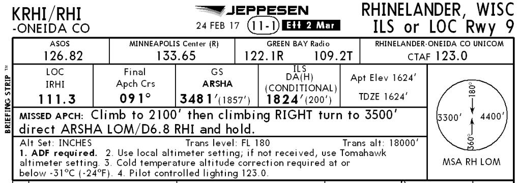
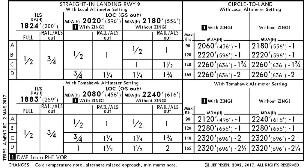
3 Is Missing METAR Data a significant issue? Answer: It Depends Not Significant: IF Data is missing for destination airport & the METAR data can be obtained prior to arrival. or IF Local FAA Principal Operating Inspector (POI) Office approves alternative procedures & they are included in the airline s Operational Specifications (Ops Specs) document. Significant for Many Operators: AAL, DAL, FedEx, UAL, etc. DAL examples: o 221 Missing METAR cases in last 1 year o Recent Significant Impact at Rhinelander: EXAMPLE RHI MISSING VIS Missing Date 20 & 21 May 2017 Missing Time Updated report filed 16z 21 May Missing Items Visibility Contacted ASOS & GRB NWS FOR UPDATE Operational Impact MISSING SINCE 20/1953Z. 1 FLIGHT STUCK IN RHI CANNOT DEPART. 2 FLTS TODAY THAT CANNOT TAKE OFF INBOUND TO RHI. LAST FLT TODAY IS OVERNIGHT AND WILL AFFECT FIRST FLT IN AM SO 4 FLTS SO FAR ARE AFFECTED. CONTACTED GRB NWS. TECHNICIAN CANNOT FIX..PARTS ON BACK ORDER. NO ESTIMATE OF REPAIR.
 Example METARs KRHI 221953Z AUTO 24010G17KT 10SM FEW042 FEW049 OVC060 13/06 A2980 RMK AO2 RAB28E51 SLP095 P0000 T01280061 TSNO= KRHI 221853Z AUTO 25011G18KT FEW039 BKN049 OVC075")
4 Can the Flying Public be Better Served? Rhinelander, WI (RHI) Example METARs KRHI Z AUTO 24010G17KT 10SM FEW042 FEW049 OVC060 13/06 A2980 RMK AO2 RAB28E51 SLP095 P0000 T TSNO= KRHI Z AUTO 25011G18KT FEW039 BKN049 OVC075 13/05 A2979 RMK AO2 PK WND 24027/1822 SLP093 T TSNO $= It was not clear skies & a million miles Visibility. But, visibility was more Visibility missing for a total of 48 hours KRHI Z AUTO 08011KT -RA SCT050 BKN080 OVC090 09/05 A3005 RMK AO2 SLP189 P T TSNO= KRHI Z AUTO 10015KT -RA OVC055 12/03 A3009 RMK AO2 RAB44 SLP200 P0000 T TSNO $= KRHI Z AUTO 10019G25KT 10SM FEW055 OVC090 13/M01 A3009 RMK AO2 PK WND 08031/1800 SLP199 T TSNO= than adequate for safe operations during the entire outage at RHI over those 2 days!
5 Rhinelander Dispatch Perspective
 Example Unable to depart RHI for 2 days because ASOS visibility was not in")
6 Can the Flying Public be Better Served? Rhinelander, WI (RHI) Example Unable to depart RHI for 2 days because ASOS visibility was not in METAR Could not fly into RHI either. Customers were the losers
 / Minimum Decision Altitude (MDA) Temperature (If RTMA not available) - Use Nearby Stns Temperatures & Enhanced Wx Info System (EWINS) approved")
 Product For Missing Variables in addition to Temperature NWS in Coordination with FAA plans to perform an analysis")
7 Missing METARs Proposed Short & Long Term Solutions Any Airport in the World: SHORT TERM Implementation Use EWINS Authority For Missing Altimeter or Temperature Altimeter - Use Nearby Stn s Altimeter & Adjust DH (Decision Height) / Minimum Decision Altitude (MDA) Temperature (If RTMA not available) - Use Nearby Stns Temperatures & Enhanced Wx Info System (EWINS) approved Met will finalize value For Wind, Visibility, Present Wx &/or Sky Condition EWINS approved Met & Operator s FAA Liaison to contact FAA CMO on case-by-case basis for formal OK. LONGER TERM Implementation Use NWS Real Time Mesoscale Analysis (RTMA) Product For Missing Variables in addition to Temperature NWS in Coordination with FAA plans to perform an analysis of RTMA accuracy
8 Can the Flying Public be Better Served? Use EWINS Authority-Short Term Delta facilitated discussions in May & June with Industry, NWS & FAA. Delta has completed analysis of use of nearby altimeter values 1.28M Hours sampled for 10 hub airports each with 6 remote altimeter ready stations (each station at least 2 years of data) o 70 hrs of the 1.28M hrs missed the altimeter set based on the round up to the next 100 ft procedure. o Approx 60% missed high - which would increase the safety margin between aircraft & obstacles. o approx 60% were also during conditions that would eliminate the use of the procedure due to pressure failing rapidly (tstrm in vcnty, etc) o That leaves less than 20hrs that miss low without an explanation of the 1.28M hours. Answer: It Depends Use of RTMA - Longer Term A4A Member Airlines; FAA; & NWS coordinated in late 2014 & 2015 Use of RTMA for Temperature was approved eff 01 June A4A Member Airlines have requested expanded use of RTMA to other missing METAR variables. NWS is in process of getting funding to perform an analysis Est analysis completion date Sep 2018
9 Missing METAR Data Can Ops be Safely Conducted w/ EWINS Authority? Data Analysis of Proposed Procedures Status Missing Altimeter: Procedure is the furthest along & appears sound o Uses adjustment to landing minimums based on remote airport distance & elevation change Similar to one used by FAA when constructing approach procedures o Considers factors at the proposed remote location such as PRESRR/PRESFR, fronts, strong pressure gradients, & 1st METARS after a period of no reporting o Final procedure will be mindful of impact of pressure on takeoff performance o Airport & aircraft capabilities will be factored into decision-making Missing Temperature: Concept is mostly developed & needs further analysis o Single remote station has not proven accurate in early analysis o Consideration for effect of temperature on a/c performance will be key in final procedure Missing Visibility, Wind, & Present Weather: Procedures are in their infancy. o Airport & aircraft capabilities will be factored into decision-making Ceiling: Rarely required by regulations, o But might be significant in operational decision-making where METAR data are missing.
10 Missing METAR Data Apply SMS & EWINS Authority Use of Safety Management System (SMS) Development of procedures for operating when METARS or portions of METARS are missing is based on SMS principals ensuring risk is reduced to an acceptable level. Weather Conditions & Physical Environment How far away is/are remote source(s)? What is observed on satellite imagery? What is being observed on radar? Are there frontal systems in the area? Are there other weather systems in the area that might invalidate a remote station? Are there terrain considerations which might invalidate a remote source? Aircraft & Flight Crew Capabilities Is pilot in command low time? Navigation capabilities of aircraft? Is aircraft equipped with a radar altimeter? Is aircraft equipped w/ EGPWS? What is the performance impact for an imperfect estimation? (headwind/tailwind, pressure, temperature) Airport Equipment & Airport Capabilities ATC tower on the airport? ATC offer radar coverage of the area? Precision instrument approach available? Runway have visual glideslope guidance? What is the MSA? What are circling minimums?
11 Missing METAR Data Summary & Goals Summary Work is underway on both Short and Longer Term Implementation Efforts to Address missing METAR data & to Better Serve the Flying Public while Maintaining a Comparable Level of Safety. Goals: Short Term - EWINS Authority procedures for Altimeter & Temperature Complete coordination with FAA & NWS - Target Date: 01August 2017 Longer Term - RTMA use for missing variables other than Temperature Complete analysis by NWS of RTMA accuracy - Target Date: 30 Sept 2018
METEOROLOGY PANEL (METP) WORKING GROUP- METEOROLOGICAL OPERATION GROUP (MOG) FIRST MEETING
 WORKING GROUP- METEOROLOGICAL OPERATION GROUP (MOG) FIRST MEETING") 8 28/7/15 METEOROLOGY PANEL (METP) WORKING GROUP- METEOROLOGICAL OPERATION GROUP (MOG) FIRST MEETING Gatwick, United Kingdom, 08 to 11 September 2015 Agenda Item 3: Matters relating to SADIS 3.3: Operations
8 28/7/15 METEOROLOGY PANEL (METP) WORKING GROUP- METEOROLOGICAL OPERATION GROUP (MOG) FIRST MEETING Gatwick, United Kingdom, 08 to 11 September 2015 Agenda Item 3: Matters relating to SADIS 3.3: Operations
NBAA Friends and partners of Aviation Weather Orlando, Flordia October 23, Presented By: Rex Alexander, National EMS Pilots Association
 NBAA Friends and partners of Aviation Weather Orlando, Flordia October 23, 2014 Presented By: Rex Alexander, National EMS Pilots Association HEMS Accidents 1983-2013 References from NTSB Database Total
AERODROME METEOROLOGICAL OBSERVATION AND FORECAST STUDY GROUP (AMOFSG)
") 24/4/13 AERODROME METEOROLOGICAL OBSERVATION AND FORECAST STUDY GROUP (AMOFSG) TENTH MEETING Montréal, 17 to 19 June 2013 Agenda Item 6: Forecasting at the aerodrome and in the terminal area and ATIS requirements
24/4/13 AERODROME METEOROLOGICAL OBSERVATION AND FORECAST STUDY GROUP (AMOFSG) TENTH MEETING Montréal, 17 to 19 June 2013 Agenda Item 6: Forecasting at the aerodrome and in the terminal area and ATIS requirements
Sources of Hourly Surface Data and Weather Maps for the U.S.
 Sources of Hourly Surface Data and Weather Maps for the U.S. Weather Underground Weather Underground http://www.wunderground.com/history/ maintains a deep archive of hourly reports for around the world.
Advanced Weather Technology
 Advanced Weather Technology Tuesday, October 16, 2018, 1:00 PM 2:00 PM PRESENTED BY: Gary Pokodner, FAA WTIC Program Manager Agenda Overview Augmented reality mobile application Crowd Sourcing Visibility
KEY TO DECODING THE U.S. METAR OBSERVATION REPORT
 KEY TO DECODING THE U.S. METAR OBSERVATION REPORT Example METAR Report METAR KABC 121755Z AUTO 21016G24KT 180V240 1SM R11/P6000FT -RA BR BKN015 0VC025 06/04 A2990 RMK A02 PK WND 20032/25 WSHFT 1715 VIS
National Transportation Safety Board Office of Aviation Safety Washington, D.C December 10, 2012 WEATHER STUDY DCA13RA025
 A. ACCIDENT National Transportation Safety Board Office of Aviation Safety Washington, D.C. 20594-2000 December 10, 2012 WEATHER STUDY DCA13RA025 Location: Monterrey, Mexico Date: December 9, 2012 Time:
Atmospheric Pressure. Pressure Altimeter. Pressure Altimeter
 Atmospheric Pressure The : An instrument to measure altitude based on an aneroid barometer. It can be adjusted for changes in atmospheric pressure 1 2 Altimeter Setting Is not SLP, but close to it. If
Metar And Taf Decoding
 Metar And Taf Decoding 1 / 6 2 / 6 3 / 6 Metar And Taf Decoding examples: kmem 230853z auto 18014g18kt 10sm clr 16/m02 a3008 rmk ao2 slp117 t01561022 tsno $ klax 161550z cor 11004kt 2 1/2sm hz bkn011 bkn015
AVIATION INVESTIGATION REPORT A04A0057 WING SCRAPE DURING A REJECTED LANDING
 AVIATION INVESTIGATION REPORT A04A0057 WING SCRAPE DURING A REJECTED LANDING CARGOJET AIRWAYS LIMITED BOEING 727-225 C-GCJB GREATER MONCTON INTERNATIONAL AIRPORT MONCTON, NEW BRUNSWICK 28 MAY 2004 The
Sources of Hourly Surface Data and Weather Maps for the U.S.
 Sources of Hourly Surface Data and Weather Maps for the U.S. Weather Underground Weather Underground http://www.wunderground.com/history/ maintains a deep archive of hourly reports for around the world.
Section 7: Hazard Avoidance
 7.1 In-Flight Hazard Awareness Section 7: Hazard Avoidance As technology improves, pilots have more and more real-time information within reach in all phases of flight. Terrain proximity, real-time weather
Weather Technology in the Cockpit (WTIC) Shortfall Analysis of Weather Information in Remote Airspace Friends and Partners of Aviation Weather Summer
 Shortfall Analysis of Weather Information in Remote Airspace Friends and Partners of Aviation Weather Summer") Weather Technology in the Cockpit (WTIC) Shortfall Analysis of Weather Information in Remote Airspace Friends and Partners of Aviation Weather Summer Meeting Tim Myers Metron Aviation August 26, 2015 2
Weather Technology in the Cockpit (WTIC) Shortfall Analysis of Weather Information in Remote Airspace Friends and Partners of Aviation Weather Summer Meeting Tim Myers Metron Aviation August 26, 2015 2
Progress in Aviation Weather Forecasting for ATM Decision Making FPAW 2010
 Progress in Aviation Weather Forecasting for ATM Decision Making FPAW 2010 Jim Evans Marilyn Wolfson 21 October 2010-1 Overview (1) Integration with storm avoidance models and ATC route usage models (2)
Recap of the NTSB PIREP Forum: Optimizing Safety Benefits for Pilots, ATC, and Meteorologists. Paul Suffern NTSB Meteorologist
 Recap of the NTSB PIREP Forum: Optimizing Safety Benefits for Pilots, ATC, and Meteorologists Paul Suffern NTSB Meteorologist 1 2 Wx Accident Trend 3 Preflight Planning TAF KRDU 162340Z 1700/1724 28003KT
TAIWIN: Operational Concept Review
 TAIWIN: Operational Concept Review S.D. Green November 19, 2015 Overview Changes to FAR Parts 25 and 33 including FAR 25.1420 and Appendix O, will allow limited icing certification for transport category
Decoding Observations and Terminal Aerodrome Forecasts. Weather Observer/Forecaster O-LD 18 th Weather Squadron Ft Polk, LA
 Decoding Observations and Terminal Aerodrome Forecasts Weather Observer/Forecaster O-LD 18 th Weather Squadron Ft Polk, LA Part I. Decoding Observations What types of data goes into a weather observation?
Complementary Use of Airborne Wx Radar & Datalink Graphical Wx
 Complementary Use of Airborne Wx Radar & Datalink Graphical Wx What if to What next? Cheri Haynes XCELAR Friends/Partners in Aviation Weather Forum October 31, 2012 What if to What next? Today there are
ERTH 465 Fall Laboratory Exercise 5. Surface Weather Observations (METARS) and Frontal Analysis (300 pts)
 and Frontal Analysis (300 pts)") ERTH 465 Fall 2017 Laboratory Exercise 5 Surface Weather Observations (METARS) and Frontal Analysis (300 pts) Insert in ringed-three hole binder. Point deductions for sloppy or late work. Due date: Tuesday
ERTH 465 Fall 2017 Laboratory Exercise 5 Surface Weather Observations (METARS) and Frontal Analysis (300 pts) Insert in ringed-three hole binder. Point deductions for sloppy or late work. Due date: Tuesday
The Ice Crystal Icing Hazard & Risk Mitigation: Delta Air Lines Perspective
 The Ice Crystal Icing Hazard & Risk Mitigation: Delta Air Lines Perspective Bob Culver, Chief Line Check Pilot & Tom Fahey, Mgr. Meteorology Friends/Partners Aviation Weather (FPAW) 19 November 2015 Las
Traffic and Weather. Soaring Safety Foundation. Tom Johnson CFIG
 Traffic and Weather Soaring Safety Foundation Tom Johnson CFIG Weather Contents Weather Gathering Sources Weather Acquisition Enroute Weather Analysis Weather Hazards Weather in the Landing Pattern Basic
Friends & Partners in Aviation Weather: Part 135
 Friends & Partners in Aviation Weather: Part 135 Thursday, October 12, 2017 Jason E. Herman, CAM Chairman, NBAA Part 135 Subcommittee Part 135 On-Demand Operations A mix of many different operational environments
The Informed Scheduler
 The Informed Scheduler Thursday, January 21, 2016 1:00 p.m. 2:30 p.m. PRESENTED BY: Vinton Brown, Flight Safety International James M. Kohler, Chief Pilot, DuPont Andrew M. Bourland, CAM, Chief Pilot,
Precision Approaches
 Precision Approaches The purpose of an IFR approach Precision approaches Non-Precision Approaches An approach where you have means of measuring deviation of the desired vertical profile, is a precision
Federal Aviation Administration
 High Ice Water Content Research International Collaboration and Field Campaign Presented to: FPAW By: Tom Bond Date: Statement of Need Over the past 10+ years, it has been recognized that jet engine powerloss
AWOS Level Descriptions
 AWOS Level Descriptions AWOS System Configurations. The AWOS is a modular system utilizing a central processor which may receive input from several sensors. Eight standard groups of sensors are defined
AERODROME METEOROLOGICAL OBSERVATION AND FORECAST STUDY GROUP (AMOFSG)
") AMOFSG/10-IP/4 21/5/13 AERODROME METEOROLOGICAL OBSERVATION AND FORECAST STUDY GROUP (AMOFSG) TENTH MEETING Montréal, 17 to 19 June 2013 Agenda Item 5: Aerodrome observations AUTOMATED CLOUD INFORMATION
AMOFSG/10-IP/4 21/5/13 AERODROME METEOROLOGICAL OBSERVATION AND FORECAST STUDY GROUP (AMOFSG) TENTH MEETING Montréal, 17 to 19 June 2013 Agenda Item 5: Aerodrome observations AUTOMATED CLOUD INFORMATION
System Wide Information Management. Peder Blomqvist (LFV) Xavier Jourdain (Thales)
 Xavier Jourdain (Thales)") System Wide Information Management Peder Blomqvist (LFV) Xavier Jourdain (Thales) Information management challenges Incompatible operations Fragmentation Low levels of interoperability Limited adaptability
System Wide Information Management Peder Blomqvist (LFV) Xavier Jourdain (Thales) Information management challenges Incompatible operations Fragmentation Low levels of interoperability Limited adaptability
The current status, functions, challenges and needs of South Sudan Meteorological Department (SSMD)
") The current status, functions, challenges and needs of South Sudan Meteorological Department (SSMD) Presented: by Mojwok Ogawi Modo, South Sudan Meteorological Department. Background The present SSMD was
The current status, functions, challenges and needs of South Sudan Meteorological Department (SSMD) Presented: by Mojwok Ogawi Modo, South Sudan Meteorological Department. Background The present SSMD was
NJ SURVEYORS CONFERENCE
 NJ SURVEYORS CONFERENCE PART 107 Ground School TODAY S AGENDA Regulations National Airspace System Operations Weather Loading and Performance 1 REGULATIONS Remote Pilot Certifications and Privileges When
Weather Evaluation Team (WET)
") Weather Evaluation Team (WET) Presented to: Friends and Partners in Aviation Weather Kevin Johnston ATCSCC Tom Fahey Delta Air Lines 1 WET Membership FAA Denver ARTCC Atlanta ARTCC ATCSCC Minneapolis TRACON
Weather Evaluation Team (WET) Presented to: Friends and Partners in Aviation Weather Kevin Johnston ATCSCC Tom Fahey Delta Air Lines 1 WET Membership FAA Denver ARTCC Atlanta ARTCC ATCSCC Minneapolis TRACON
ERTH 465 Fall Laboratory Exercise 5. Surface Weather Observations (METARS) and Frontal Analysis (300 pts)
 and Frontal Analysis (300 pts)") ERTH 465 Fall 2017 Laboratory Exercise 5 Surface Weather Observations (METARS) and Frontal Analysis (300 pts) Insert in ringed-three hole binder. Point deductions for sloppy or late work. Due date: Tuesday
ERTH 465 Fall 2017 Laboratory Exercise 5 Surface Weather Observations (METARS) and Frontal Analysis (300 pts) Insert in ringed-three hole binder. Point deductions for sloppy or late work. Due date: Tuesday
Volcanic Ash. Risk Management. GE Aviation Perspective on Operations in a Volcanic Ash Environment. Roger Dinius Jan. 20, 2011
 Volcanic Ash Risk Management Perspective on Operations in a Volcanic Ash Environment Roger Dinius Jan. 20, 2011 Volcano Eruption Impacts Air Travel & Commerce April 15 th eruption closed a large part of
Pilot briefing ENTC - Tromsø airport, Langnes
 Pilot briefing ENTC - Tromsø airport, Langnes NOTE: The content in this briefing will not be updated as frequently as AIP Norway. Make sure you always check relevant information in the latest edition of
Earth and Atmospheric Sciences. Sky condition. Prof. J. Haase EAS535 EAS535
 Sky condition Prof. J. Haase Federal Meteorological Handbook http://www.ofcm.gov/fmh-1/fmh1.htm Estimating cloud height Report cloud levels to nearest 100 feet below 5000 feet (in practice, human observers
Weather Technology in the Cockpit (WTIC) Program Program Update. Friends/Partners of Aviation Weather (FPAW) November 2, 2016
 Program Program Update. Friends/Partners of Aviation Weather (FPAW) November 2, 2016") Weather Technology in the Cockpit (WTIC) Program Program Update Friends/Partners of Aviation Weather (FPAW) November 2, 2016 Presented by Gary Pokodner, WTIC Program Manager Phone: 202.267.2786 Email:
Weather Technology in the Cockpit (WTIC) Program Program Update Friends/Partners of Aviation Weather (FPAW) November 2, 2016 Presented by Gary Pokodner, WTIC Program Manager Phone: 202.267.2786 Email:
Weather Considerations for UAS Integration
 Weather Considerations for UAS Integration Scot Campbell 8 December 2016 Sponsor: Steve Abelman, ANG-C6 DISTRIBUTION STATEMENT A. Approved for public release: distribution unlimited. Legal Notices This
AOPA. Mitigating Turbulence Impacts in Aviation Operations. General Aviation Perspective
 AOPA Mitigating Turbulence Impacts in Aviation Operations General Aviation Perspective Rune Duke Senior Director, Airspace & Air Traffic Services Aircraft Owners & Pilots Association AOPA Air Safety Institute
P1.1 THE NATIONAL AVIATION WEATHER PROGRAM: AN UPDATE ON IMPLEMENTATION
 P1.1 THE NATIONAL AVIATION WEATHER PROGRAM: AN UPDATE ON IMPLEMENTATION Thomas S. Fraim* 1, Mary M. Cairns 1, and Anthony R. Ramirez 2 1 NOAA/OFCM, Silver Spring, MD 2 Science and Technology Corporation,
Additional capacity with Machine Learning. ART meeting Bretigny Bob Graham & Floris Herrema
 Additional capacity with Machine Learning ART meeting Bretigny Bob Graham & Floris Herrema Runway Throughput Challenge 16 to 28 congested airports 1.5+ million flights not catered for 160+ million people
Network Severe Weather Programme
 Network Severe Weather Programme David White Network Severe Weather programme Severe Weather is an EVENT with associated Uncertainty which requires Managing to protect the ATC environment & the integrity
The WMO Aviation Research & Demonstration Project (AvRDP) at Paris-CDG airport. Pauline Jaunet Météo-France
 at Paris-CDG airport. Pauline Jaunet Météo-France") The WMO Aviation Research & Demonstration Project (AvRDP) at Paris-CDG airport Pauline Jaunet Météo-France AvRDP focus points Aviation Research Demonstration Project Joint effort between CAS/WWRP and CaeM
The WMO Aviation Research & Demonstration Project (AvRDP) at Paris-CDG airport Pauline Jaunet Météo-France AvRDP focus points Aviation Research Demonstration Project Joint effort between CAS/WWRP and CaeM
Advances in Weather Technology
 Advances in Weather Technology Dr. G. Brant Foote National Center for Atmospheric Research 16 May 2001 NCAR Research Results in Aviation Weather Built on the foundation of the nation s long-standing investment
An Isentropic Perspective on Two Cases of Elevated Convection. Patrick S. Market Dept. of Soil, Env. & Atmospheric Sciences University of Missouri
 An Isentropic Perspective on Two Cases of Elevated Convection Patrick S. Market Dept. of Soil, Env. & Atmospheric Sciences University of Missouri Elevated Convection INTRODUCTION Colman (1990a,b) Initiated
2012 National SAFECON SCAN Test
 Today is Friday, November 18, 2011. Your school's flight team has recently qualified for the National SAFECON. You have a couple days off from school and decide to return to your hometown of Rhinelander,
Building a 4-D Weather Data Cube for the NextGen Initial Operating Capability (IOC)
") Building a 4-D Weather Data Cube for the NextGen Initial Operating Capability (IOC) Friends/Partners in Aviation Weather Vision Forum July 15, 2008 Bruce Lambert - DoD Tom Ryan FAA Jason Tuell NWS 1 Overview
Building a 4-D Weather Data Cube for the NextGen Initial Operating Capability (IOC) Friends/Partners in Aviation Weather Vision Forum July 15, 2008 Bruce Lambert - DoD Tom Ryan FAA Jason Tuell NWS 1 Overview
Industry Taskforce Presentations
 Industry Taskforce Presentations December 18, 2013 Washington, D.C. Facilitators: Rex Alexander, National EMS Pilots Association Tom Judge, International Helicopter Safety Team Presentations HEMS Part
Strengthening the CDM triad: A view from the cockpit
 Strengthening the CDM triad: A view from the cockpit Captain Rocky Stone Chief Technical Pilot United Airlines Friends and Partners in Aviation Weather July 21, 2010 NextGen Weather Concept Current NextGen
Volcanic Ash Operator Experience
 Volcanic Ash Operator Experience Eyjafjallajokull Eme Tillema Dep VP ATM KLM Flight Operations Cologne 9 Sept 2010 1 Facts Eyjafjallajokull Eruption on the 14 th of April 2010 European Airspace Closure
MxVision WeatherSentry Web Services Content Guide
 MxVision WeatherSentry Web Services Content Guide July 2014 DTN 11400 Rupp Drive Minneapolis, MN 55337 00.1.952.890.0609 This document and the software it describes are copyrighted with all rights reserved.
Technical Description for Aventus NowCast & AIR Service Line
 Technical Description for Aventus NowCast & AIR Service Line This document has been assembled as a question and answer sheet for the technical aspects of the Aventus NowCast Service. It is designed to
NextGen Update. Cecilia Miner May, 2017
 NextGen Update Cecilia Miner May, 2017 Agenda What s changed? NextGen Background FAA NextGen Weather Architecture NextGen Weather Processor Aviation Weather Display Common Support Services - Weather NWS
FAA AIRFIELD LIGHTING STANDARDS UPDATE
 FAA AIRFIELD LIGHTING STANDARDS UPDATE Present to: IES ALC GOVERNMENT LIGHTING COMMITTEE WASHINGTON, DC May 7, 2015 Tom Mai FAA Airport Engineering Division (AAS-100) Agenda FAA Airfield Lighting Equipment
The Role of Meteorological Forecast Verification in Aviation. Günter Mahringer, November 2012
 The Role of Meteorological Forecast Verification in Aviation Günter Mahringer, November 2012 Introduction Aviation Meteorology is internationally regulated. Services are standardized and harmonized by
Strengthening the CDM triad: A view from the cockpit
 Strengthening the CDM triad: A view from the cockpit Captain Rocky Stone Chief Technical Pilot United Airlines Friends and Partners in Aviation Weather October 21, 2010 NextGen weather concept Current
Quantifying Wx Benefits
 Quantifying Wx Benefits Refresher on how weather was justified. Lessons learned. Incorporating airline industry needs and benchmarks to validate business cases? Nicholas Stoer, Consultant, Retired FAA
LANDMARK TM. Class B TAWS
 LANDMARK TM Class B TAWS WAAS-GPS Accurate - 320 Mile Range - Easily Integrated Introducing the LandMark Model 8100 LandMark is the first stand-alone Class B TAWS to offer an optional WAAS-GPS sensor.
WEATHER SOURCES FSS WXBRIEF
 FSS 1-800-WXBRIEF WEATHER SOURCES ASOS / METARS KSNT, KMYL, KLLJ, KSMN AOPA/NOAA Satellite, Radar, Surface, Winds, etc. NIFC TFR s Noaa Automated Surface:METAR/ RAWS (Remote Automated WX Station) BLM/USFS
Meteorology METARs. References: FTGU pages AWWS:
 Meteorology 5.09 METARs References: FTGU pages 160-163 AWWS: www.flightplanning.navcanada.ca 5.09 METARs MTPs: Weather Observing Stations METARs Weather Observing Stations Weather observation are taken
Analysis Capabilities Developed in Support of WTIC Research
 Analysis Capabilities Developed in Support of WTIC Research Tom Reynolds Air Traffic Control Systems Group Friends & Partners of Aviation Weather (FPAW) Meeting Washington, DC, August 3, 2016 Distribution
Regional Hazardous Weather Advisory Centres (RHWACs)
") Regional Hazardous Weather Advisory Centres (RHWACs) The following outlines the criteria for the selection of RHWACs based on operational and functional requirements 1. Basic Principles The RHWAC must:
Regional Hazardous Weather Advisory Centres (RHWACs) The following outlines the criteria for the selection of RHWACs based on operational and functional requirements 1. Basic Principles The RHWAC must:
Meteorology METARs Weather Observing Stations. MTPs: 5.09 METARs References: FTGU pages AWWS:
 Meteorology 5.09 References: FTGU pages 160-163 AWWS: www.flightplanning.navcanada.ca MTPs: Weather Observing Stations 5.09 Weather Observing Stations Weather observation are taken every hour at selected
FAA Weather Research Plans
 FAA Weather Research Plans Presented to: Friends /Partners in Aviation Weather Vision Forum By: Ray Moy FAA Aviation Weather Office Date: Aviation Weather Research Program (AWRP) Purpose: Applied Research
A Mission View of Aviation Wx Requirements. Mark Zettlemoyer, NWS/JPDO James Tauss, SENSIS FPAW, July
 A Mission View of Aviation Wx Requirements Mark Zettlemoyer, NWS/JPDO James Tauss, SENSIS FPAW, July 24 2013 1 A Mission View of Aviation Weather Requirements Ketchup & Mustard but with the entire burger
Example of Aircraft Climb and Maneuvering Performance. Dr. Antonio A. Trani Professor
 Example of Aircraft Climb and Maneuvering Performance CEE 5614 Analysis of Air Transportation Systems Dr. Antonio A. Trani Professor Example - Aircraft Climb Performance Aircraft maneuvering performance
Aviation Weather Reports
 Aviation Weather Reports Aviation Weather Reports METAR: hourly weather report (issued on the hour every hour) SPECI: special weather observations issued at times other than on the hour, as a result of
NINTH MEETING DISPLAY IN ATS UNITS. (Presented SUMMARY
 AMOFSG/9-SN No. 26 12/8/11 AERODROME METEOROLOGICAL OBSERVATION AND FORECAST STUDY GROUP (AMOFSG) NINTH MEETING Montréal, 26 to 30 September 2011 Agenda Item 6: MET informationn to support ATM UPDATING
Gridded Localized Aviation MOS Program (LAMP) Guidance for Aviation Forecasting
 Guidance for Aviation Forecasting") Gridded Localized Aviation MOS Program (LAMP) Guidance for Aviation Forecasting Judy E. Ghirardelli and Bob Glahn National Weather Service Meteorological Development Laboratory August 2, 2011 15th Conference
Gridded Localized Aviation MOS Program (LAMP) Guidance for Aviation Forecasting Judy E. Ghirardelli and Bob Glahn National Weather Service Meteorological Development Laboratory August 2, 2011 15th Conference
Gleim Private Pilot FAA Knowledge Test 2015 Edition, 1st Printing Updates July 2015
 Page 1 of 6 Gleim Private Pilot FAA Knowledge Test 2015 Edition, 1st Printing Updates July 2015 NOTE: Deleted text is displayed with a line through it. New text is shown with a blue background. If you
1.1 ATM-WEATHER INTEGRATION AND TRANSLATION MODEL. Steve Bradford, David J. Pace Federal Aviation Administration, Washington, DC
 1.1 ATM-WEATHER INTEGRATION AND TRANSLATION MODEL Steve Bradford, David J. Pace Federal Aviation Administration, Washington, DC Matt Fronzak *, Mark Huberdeau, Claudia McKnight, Gene Wilhelm The MITRE
Acquisition of Multi-Function Equipment at DIA: Conditions, Factors, Considerations & Integration. Presented by Mike Carlson September 20, 2012
 Acquisition of Multi-Function Equipment at DIA: Conditions, Factors, Considerations & Integration Presented by Mike Carlson September 20, 2012 1 Denver International Airport 5 Runways 12,000 /. (3,658m)
4.3 AVIATION APPLICATIONS OF TAMDAR AIRCRAFT DATA REPORTS
 4.3 AVIATION APPLICATIONS OF TAMDAR AIRCRAFT DATA REPORTS Richard D. Mamrosh NWS Green Bay, WI Taumi S. Daniels NASA Langley, Hampton, VA William R. Moninger Earth System Research Laboratory, Boulder,
Doppler Weather Radars and Weather Decision Support for DP Vessels
 Author s Name Name of the Paper Session DYNAMIC POSITIONING CONFERENCE October 14-15, 2014 RISK SESSION Doppler Weather Radars and By Michael D. Eilts and Mike Arellano Weather Decision Technologies, Inc.
University of Maryland. Monday, November 7, 11
 AARON SCHULMAN NEIL SPRING University of Maryland Residential links may fail Links are not redundant Equipment updates are rare Equipment operates in an uncontrolled environment photo credit: Ode Street
Evaluation of Collaborative Rationing of En Route Resources. Josh Marron, Antonio Abad Bill Hall, Francis Carr, Steve Kolitz 25 Sept 2003
 Evaluation of Collaborative Rationing of En Route Resources Josh Marron, Antonio Abad Bill Hall, Francis Carr, Steve Kolitz 25 Sept 2003 Outline The need for collaborative en route rationing Proposed routing
Sky Cover: Shining Light on a Gloomy Problem
 Sky Cover: Shining Light on a Gloomy Problem Jordan Gerth Cooperative Institute for Meteorological Satellite Studies, Space Science and Engineering Center University of Wisconsin Madison 23 July 2013 1
The enduring fog and low cloud episode of 5-10 December 2015: Big Bubble Fog Trouble
 1. Overview The enduring fog and low cloud episode of 5-10 December 2015: Big Bubble Fog Trouble By Richard H. Grumm National Weather Service State College, PA An enduring low cloud and fog episode affected
Safety in Numbers SKYWATCH 497. The affordable original.
 SKYWATCH 497 Safety in Numbers The affordable original. For over 10 years, pilots have trusted SkyWatch Collision Avoidance Systems to help them fly safely. SkyWatch was the first Active Collision Avoidance
CAP 437 Offshore Meteorological Observer Training
 CAP 437 Offshore Meteorological Observer Training Training for Meteorological Observers in support of Offshore Helicopter Operations CAP 437 Offshore Meteorological Observer Training Page 1 Meteorological
CMO Terminal Aerodrome Forecast (TAF) Verification Programme (CMOTafV)
 Verification Programme (CMOTafV)") CMO Terminal Aerodrome Forecast (TAF) Verification Programme (CMOTafV) Kathy-Ann Caesar Meteorologist Caribbean Meteorological Council - 47 St. Vincent, 2007 CMOTafV TAF Verification Programme Project:
CMO Terminal Aerodrome Forecast (TAF) Verification Programme (CMOTafV) Kathy-Ann Caesar Meteorologist Caribbean Meteorological Council - 47 St. Vincent, 2007 CMOTafV TAF Verification Programme Project:
MetConsole AWOS. (Automated Weather Observation System) Make the most of your energy SM
 Make the most of your energy SM") MetConsole AWOS (Automated Weather Observation System) Meets your aviation weather needs with inherent flexibility, proven reliability Make the most of your energy SM Automated Weather Observation System
MetConsole AWOS (Automated Weather Observation System) Meets your aviation weather needs with inherent flexibility, proven reliability Make the most of your energy SM Automated Weather Observation System
National Transportation Safety Board Aviation Accident Final Report
 National Transportation Safety Board Aviation Accident Final Report Location: Elk City, OK Accident Number: Date & Time: 02/03/2014, 2300 CST Registration: N61YP Aircraft: CESSNA 525 Aircraft Damage: Substantial
Multi-Function Display Pilot s Guide Addendum
 Multi-Function Display Pilot s Guide Addendum Software Release 4.2 or Later 600-00344-000 Rev: 01-1- EX500/EX600 Document Revision History Date Revision Description February 21, 2018 00 Initial Release
Symbology Modification for Climate Studies. Rich Baldwin (NCDC/NOAA) Glen Reid (IMSG)
 Glen Reid (IMSG)") Symbology Modification for Climate Studies Rich Baldwin (NCDC/NOAA) Glen Reid (IMSG) June 3, 2005 Abstract The National Climatic Data Center archives worldwide weather data from the present date back to
Symbology Modification for Climate Studies Rich Baldwin (NCDC/NOAA) Glen Reid (IMSG) June 3, 2005 Abstract The National Climatic Data Center archives worldwide weather data from the present date back to
Montréal, 7 to 18 July 2014
 INTERNATIONAL CIVIL AVIATION ORGANIZATION WORLD METEOROLOGICAL ORGANIZATION MET/14-WP/34 28/5/14 Meteorology (MET) Divisional Meeting (2014) Commission for Aeronautical Meteorology Fifteenth Session Montréal,
Emerging Aviation Weather Research at MIT Lincoln Laboratory*
 Emerging Aviation Weather Research at MIT Lincoln Laboratory* Haig 19 November 2015 *This work was sponsored by the Federal Aviation Administration under Air Force Contract No. FA8721-05-C-0002. Opinions,
Weather Needs for UAS Operations
 Minneapolis - Denver - Washington, D.C. Weather Needs for UAS Operations Brian Haynes - President November 2016 1 Sensurion Background: 10-year company history UAS Weather Needs Sensurion Perspective Extensive
Unmanned Aircraft System Well Clear
 Unmanned Aircraft System Well Clear Dr. Roland Weibel 18 November 2014 Sponsors: Neal Suchy, FAA TCAS Program Manager, Surveillance Services, AJM-233 Jim Williams, FAA Unmanned Aircraft Systems Integration
University of Maryland. Tuesday, February 7, 12
 AARON SCHULMAN NEIL SPRING University of Maryland Measuring weather-related failures Identify residential IPs that will be subject to weather Ping before, during, and after a weather event Analyze the
University of Maryland. Friday, February 10, 12
 AARON SCHULMAN NEIL SPRING University of Maryland Residential links may fail Links are not redundant Equipment updates are rare Equipment operates in an uncontrolled environment photo credit: Patrick Shoemaker,
DAVE LEVIN AARON SCHULMAN
 YOUNDO LEE DAVE LEVIN NEIL SPRING RAMAKRISHNA PADMANABHAN University of Maryland AARON SCHULMAN Stanford Weather causes residential link failures Lightning destroys equipment and causes interference Water
Real-Time defenses. FlightOPS
 Real-Time defenses By Wayne Rosenkrans Integrating data from terminal Doppler weather radar and anemometer-based wind shear alerting systems during the past years has further reduced, but not eliminated,
Murphy hops a ride or can I (you) fly the PC-12 without some of our goodies.
 fly the PC-12 without some of our goodies.") Murphy hops a ride or can I (you) fly the PC-12 without some of our goodies. By John Morris On a late November flight out of Central Florida to the heart of Texas I discover that the RDR 2000 has decided
Murphy hops a ride or can I (you) fly the PC-12 without some of our goodies. By John Morris On a late November flight out of Central Florida to the heart of Texas I discover that the RDR 2000 has decided
10.2 WEATHER INTEGRATION CONCEPT OF OPERATIONS FOR TRANSFORMING THE NATIONAL AIRSPACE SYSTEM
 10.2 WEATHER INTEGRATION CONCEPT OF OPERATIONS FOR TRANSFORMING THE NATIONAL AIRSPACE SYSTEM Cheryl G. Souders FAA Air Traffic Organization, Operations Planning Systems Engineering, Washington, DC Starr
Cross-cutting Issues Impacting Operational ATM and Cockpit Usability of Aviation Weather Technology. John McCarthy Sherrie Callon Nick Stoer
 Cross-cutting Issues Impacting Operational ATM and Cockpit Usability of Aviation Weather Technology John McCarthy Sherrie Callon Nick Stoer Introduction Air Traffic Management Coordinators are supposed
Aviation Weather Routing Tool: A Decision Aid for Manned/Unmanned Aircraft Routing
 Aviation Weather Routing Tool: A Decision Aid for Manned/Unmanned Aircraft Routing Dr. Richard Shirkey Mr. Terry Jameson Battlefield Environment Division Army Research Laboratory, WSMR rshirkeyn@arl.army.mil
Preflight Weather Analysis Lesson 4 Part 4 of 4
 Preflight Weather Analysis Lesson 4 Part 4 of 4 Presented by Find-it Fast Books Unlimited FREE Downloads of this course available at www.finditfastbooks.org 1 The slide sequence for Lesson 4 is a little
WSI Pilotbrief Optima - for ipad
 WSI Pilotbrief Optima - for ipad Anticipate, Visualize & Avoid Hazardous Weather In A Whole New Way The Weather Company, an IBM Business, delivers an ipad-based version of WSI Pilotbrief Optima. This ipad
Preventing Runway Excursions. Landing on wet / Contaminated Runways
 Preventing Runway Excursions Landing on wet / Contaminated Runways Overview Introduction Definition Runway Condition Runway Condition Reporting Pilot Operational Aspects Landing Performance Airport Operational
Preventing Runway Excursions. Landing on wet / Contaminated Runways
 Preventing Runway Excursions Landing on wet / Contaminated Runways Overview Introduction Definition Runway Condition Runway Condition Reporting Pilot Operational Aspects Landing Performance Airport Operational