Primary results from ground-based lunar observations in China
|
|
|
- Melvin Lewis
- 5 years ago
- Views:
Transcription


")


1 Primary results from ground-based lunar observations in China Presented by Lin Chen Xiuqing(Scott) Hu, Ronghua Wu,Yang Wang, Lu Zhang, Wei Wang National Satellite Meteorological Center(NSMC), CMA August 30,
2 Outline pground-based Lunar observation Implementation plunar observation location and Atmospheric observations pprimary Lunar Observation Results plessons from the experiments
3 Ground-based Lunar observation Implementation Lunar observation concept and Instrument development Lunar Imaging spectrometer Hyspectral lunar-photometer Ancillary measurement for lunar observation data processing Aerosol: Lidar or photometer Atmosphere sounding profile on-site Instrument checking and calibration Observation site selection High altitude (>2km) Clean and arid atmosphere More clear sky Observation plan design Data processing Data calibration and quality control Atmosphere correction Lunar phase and angle calculation Model validation and improvement
 Latitude:2100m")

4 Lunar observation location selection Lingshan First instrument testing Near from Beijing (122Km) Latitude:2100m No air pollution Lijiang Formal experiment Location: E, N Latitude : 3193m Near from Astronomy station

 Formal ground-based")
 Lijiang, Yunnan Lingshang, Beijing")
5 Lunar Instruments Testing experiments First Instrument Testing experiment in Lingshan, Beijing (June 24--July 3, 2015) Dunhuang, Gansu Second Instrument Testing in Dunhuang, Gansu Province (August 20--Sep 3, 2015) Formal ground-based Lunar Observation for three months in Lijiang, Yunnan (Dec 17, March 1, 2016) Lijiang, Yunnan Lingshang, Beijing
6 Ground-based Lunar instruments Lunar instruments Instruments Vendor Spectral Location Remarks Lunar imaging spectrometer AOTF imaging spectrometer Shortwave Infared imaging HSFTS Changchun SITP Xi an nm Resolution: 2~10nm 450nm~1000nm, 2~8nm 900nm~2500nm, 60 bands Lingshan, Dunhuang, Lijiang Lingshan, Dunhuang Lijiang Lunar imaging Autom tracking Manual tracking Manual tracking and imagomg Hyspectral lunarphotometer Changchun nm 1~5nm Lingshan, Dunhuang, Lijiang Lunar irradiance Autom tracking CE318U-lunarphotometer CIMEL 10 bands Dunhuang, Lijiang Lunar irradiance Autom tracking Ancillary instruments Lidar 704 Institute 532nm; 1064nm Lijiang Aerosol at night CE318 sun-photometer CIMEL 9 bands Lijiang Aerosol at daytime Reference instrument Atmosphere sounding VISALA Lijiang Atmosphere profile ASD FieldSpec 3 ASD nm Lingshan, Dunhuang, Lijiang Calibration and stability monitoring


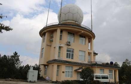
7 Lunar Observation in Lijiang, Yunnan Hyperspectral Lunar-photometer Lunar Imaging Spectrometer AOTF Imaging Spectrometer HSFTS CE318U Lunar-photometer Yulong Snow Mountain Lijiang Weather Radar station


8


9 Valid Experiments Data Weather Records This figure shows the experiments days in Lijiang. According to the weather records, we selected 10d valid experiment data for analysis
 工控机 (Industrial")

10 Atmospheric observation 望远镜 (Telescope) 显示器 (LCD) 激光器控制箱 (Laser Controller) Lidar and CE-318- Lunar for day-night aerosols optical depth 激光器 (Laser) 工控机 (Industrial Computer) 1064nm 控制机箱 (1064nm transient recorder) 鼠标 键盘 (Mouse and Keyboard) vertical profile of extinction efficiency Comparision between Lidar and CE


11 Atmospheric Profiles Temperature Profile Humity Profile VISALA TPW Watervapor /26 01/28 01/29 02/ CE318 Day AOD CE318 Night AOD Lidar Night AOD AOD Date AOD /20 12/21 12/22 12/23 12/24 12/25 12/26 12/27 01/17 01/18 01/19 01/26 01/29 02/17 02/18 02/19 Date
12 Atmospheric Correction Reference: AOD=0.06; Watervapor=0.6g/cm2 Control Case: AOD=0.08; Watervapor=0.8g/cm2 Affect in No-obsorption bands:<0.5% Affect in Week-absorption bands:1%~3%

13 Ground-based Lunar Imaging Spectrometer Imaging Spectrometer Specification Spectral range nm Spectral channels >260 Spectral sampling width 2-10nm Field of view 0.7 degree Instantaneous Field of view degree Pixels across track 253 Imaging Monitor Specification CCD pixel Field of view Equatorial Mount Specification Tracking accuracy ±7'' Equatorial Mount
 Spectral calibration : laser+")


14 Instrument calibration activity (1) Spectral calibration : laser+ Integrating sphere(sircus) (2) radiometric calibration: Lamp + Reference plate Reference detector+ Integrating sphere(lamp/leds) (3) stray light measurement LEDs integrating sphere(tunable)


15 Primary Observation Results
16 Comparison between Lunar Imaging Spectrometer and CE318-lunar (1) wavelength (2) time Normalization Imager data and CE318 Lunar data Lunar Imaging Spectrometer and CE318 lunar Cross-Comparison : (1) : 440,500,677,870nm (2)500nm: , , , Consistent trendency stability of the imaging spectrometer
 Fig 1 The lunar irradiance of 2016/01/26T18:45(Blue line is")
17 Comparison between ground-based lunar observation and Lunar Models(ROLO & MT2009) During the experiment period, 2098 hyper-spectral of lunar irradiance samples had been obtained. But only 145 irradiance meet the requirements of Quality Control(including Lunar zenith angle, Solar zenith angle, atmospheric fluctuation) Fig 1 The lunar irradiance of 2016/01/26T18:45(Blue line is MT2009 model,red line is Earth based observation,black line is ROLO model) The lunar irradiance obtained by Li Jiang observation is less than the ROLO and MT2009 Models. The difference between Li Jiang observational lunar irradiance and ROLO is 5.86% in this case( except some strong absorption bands)


 The image of the scene is scrolled on the")
 Registration the sequences of the image; (4) Do inverse")
18 High étendue static Fourier transform spectral imager Sensor: HSFTS Imaging Spctral range Pushbroom 0.9μm~2.5μm Spectral resolution 118 cm -1 IFOV 41.7μrad FOV 1.2degree Frame rate Up to 180fps Detector HgCdTe, pixels Digtization 14bit Mass 36kg HSFTS Experiment (1) Manually aim the sensor at the Moon; (2) The image of the scene is scrolled on the detector by the natural movement of the Moon. (3) Registration the sequences of the image; (4) Do inverse Fourier transform on image February 24( )
19 Comparison with Lunar model ROLO u Disk Irradiance Irradiance(W/m 2 /nm) 1.8 x 平均偏差为 18.1% The irradiance of lunar (XIOPM) The irradiance of lunar Irradiance(W/m 2 /nm) 2 x 平均偏差为 10.7% The irradiance of lunar (XIOPM) The irradiance of lunar Wavelength(nm) Wavelength(nm) Before atmosphere correction Irradiance Mean Bias=18.1% 2 月 24 日 ( ) After atmosphere correction Using MODTRAN Irradiance Mean Bias=10.7% 2 月 24 日 ( ) 中国科学院光谱成像技术重点实验室 KEY LABORATORY OF SPECTRAL IMAGING TECHNOLOGY CAS 19
20 Summary Experiences and Lessons: Lijiang is a good location for Lunar observation Instrument improvement and accuracy calibration More validation between observations and model Finding on the difference form ROLO and MT2009 model Next steps: Instrument improvement based on previous experience. Long term observation need automatic control by remote Accurate calibration and Data quality control Data processing for model validation and improvement International cooperation is welcome
21 Thanks
Preliminary results from ground-based lunar observations in China
 Preliminary results from ground-based lunar observations in China Presented by Xiuqing(Scott) Hu Lin Chen, Ronghua Wu,Yang Wang, Lu Zhang, Wei Wang, Peng Zhang National Satellite Meteorological Center(NSMC),
Lunar model validation using groundbased Hyper-spectral measurement
 Lunar model validation using groundbased Hyper-spectral measurement Yang Wang, Xiuqing Hu,Ling Chen,Yu Huang,Lu Zhang Ronghua Wu,Zhanfeng Li and Shurong Wang Changchun Institute of Optics, Fine Mehcanics
Progress Towards an Absolute Calibration of Lunar Irradiance at Reflected Solar Wavelengths
 Progress Towards an Absolute Calibration of Lunar Irradiance at Reflected Solar Wavelengths Claire Cramer, Steve Brown, Keith Lykke, John Woodward (NIST) Tom Stone (USGS) Motivation for using the Moon
Report from CMA 17th GSICS Executive Panel, Biot, 2-3 June 2016
 Report from CMA 17th GSICS Executive Panel, Biot, 2-3 June 2016 Peng Zhang Xiuqing (Scott) HU (National Satellite Meteorological Center, CMA ) GSICS-EP-17, Biot, 2-3 June 2016 1 Overall agency update from
Investigating the Efficiency of the Beijing Faint Object Spectrograph and Camera (BFOSC) of the Xinglong 2.16-m Reflector
 of the Xinglong 2.16-m Reflector") Research in Astron. Astrophys. Vol. (xx) No., http://www.raa-journal.org http://www.iop.org/journals/raa Research in Astronomy and Astrophysics Investigating the Efficiency of the Beijing Faint Object
Research in Astron. Astrophys. Vol. (xx) No., http://www.raa-journal.org http://www.iop.org/journals/raa Research in Astronomy and Astrophysics Investigating the Efficiency of the Beijing Faint Object
What are Aerosols? Suspension of very small solid particles or liquid droplets Radii typically in the range of 10nm to
 What are Aerosols? Suspension of very small solid particles or liquid droplets Radii typically in the range of 10nm to 10µm Concentrations decrease exponentially with height N(z) = N(0)exp(-z/H) Long-lived
Study of Physical Characteristics of High Apogee Space Debris
 Study of Physical Characteristics of High Apogee Space Debris Yongna Mao, Jianfeng Wang, Xiaomeng Lu, Liang Ge, Xiaojun Jiang (National Astronomical Observatories, Beijing, 100012, China) Abstract Date
FUNDAMENTALS OF REMOTE SENSING FOR RISKS ASSESSMENT. 1. Introduction
 FUNDAMENTALS OF REMOTE SENSING FOR RISKS ASSESSMENT FRANÇOIS BECKER International Space University and University Louis Pasteur, Strasbourg, France; E-mail: becker@isu.isunet.edu Abstract. Remote sensing
Aerosol impact and correction on temperature profile retrieval from MODIS
 GEOPHYSICAL RESEARCH LETTERS, VOL. 35, L13818, doi:10.1029/2008gl034419, 2008 Aerosol impact and correction on temperature profile retrieval from MODIS Jie Zhang 1,2 and Qiang Zhang 1,2 Received 24 April
Yi Liu TanSat Science Team
 12th International Workshop on Greenhouse Gas Measurements from Space The Pre Launch Status of TanSat Mission Yi Liu TanSat Science Team Institute of Atmospheric Physics, Chinese Academy of Sciences 9
ABB Remote Sensing Atmospheric Emitted Radiance Interferometer AERI system overview. Applications
 The ABB Atmospheric Emitted Radiance Interferometer AERI provides thermodynamic profiling, trace gas detection, atmospheric cloud aerosol study, air quality monitoring, and more. AERI high level overview
A Method Suitable for In-flight Calibration of a UAV Hyperspectral Remote Sensor
 A Method Suitable for In-flight Calibration of a UAV Hyperspectral Remote Sensor Haiwei Li, Hao Zhang, Zhengchao Chen Institute of Remote Sensing and Digital Earth (RADI), Chinese Academy of Sciences (CAS)
Hyperspectral Atmospheric Correction
 Hyperspectral Atmospheric Correction Bo-Cai Gao June 2015 Remote Sensing Division Naval Research Laboratory, Washington, DC USA BACKGROUND The concept of imaging spectroscopy, or hyperspectral imaging,
Interactive comment on A new method for nocturnal aerosol measurements with a lunar photometer prototype by A. Barreto et al.
 Atmos. Meas. Tech. Discuss., 5, C2450 C2459, 2012 www.atmos-meas-tech-discuss.net/5/c2450/2012/ Author(s) 2012. This work is distributed under the Creative Commons Attribute 3.0 License. Atmospheric Measurement
HICO Science Mission Overview
 HICO Science Mission Overview Michael R. Corson* and Curtiss O. Davis** * Naval Research Laboratory Washington, DC corson@nrl.navy.mil ** College of Oceanic and Atmospheric Sciences Oregon State University
TOTAL COLUMN OZONE AND SOLAR UV-B ERYTHEMAL IRRADIANCE OVER KISHINEV, MOLDOVA
 Global NEST Journal, Vol 8, No 3, pp 204-209, 2006 Copyright 2006 Global NEST Printed in Greece. All rights reserved TOTAL COLUMN OZONE AND SOLAR UV-B ERYTHEMAL IRRADIANCE OVER KISHINEV, MOLDOVA A.A. ACULININ
A new perspective on aerosol direct radiative effects in South Atlantic and Southern Africa
 A new perspective on aerosol direct radiative effects in South Atlantic and Southern Africa Ian Chang and Sundar A. Christopher Department of Atmospheric Science University of Alabama in Huntsville, U.S.A.
THE RESEARCH ON THE SPECTRAL CHARACTERISTICS OF SEA FOG BASED ON CALIOP AND MODIS DATA
 THE RESEARCH ON THE SPECTRAL CHARACTERISTICS OF SEA FOG BASED ON CALIOP AND MODIS DATA Wan Jianhua 1, *,Su Jing 1,Liu Shanwei 1,Sheng Hui 1 1 School of Geosciences, China University of Petroleum (East
Large FOV Mobile E-O Telescope for Searching and Tracking Low-earth Orbit Micro-satellites and Space Debris
 Large FOV Mobile E-O Telescope for Searching and Tracking Low-earth Orbit Micro-satellites and Space Debris WANG Jian-li, ZHAO Jin-yu, ZHANG Shi-xue Changchun Institute of Optics, Fine Mechanics and Physics,
Simulated Radiances for OMI
 Simulated Radiances for OMI document: KNMI-OMI-2000-004 version: 1.0 date: 11 February 2000 author: J.P. Veefkind approved: G.H.J. van den Oord checked: J. de Haan Index 0. Abstract 1. Introduction 2.
Tracking On-orbit Radiometric Accuracy and Stability of Suomi NPP VIIRS using Extended Low Latitude SNOs
 Tracking On-orbit Radiometric Accuracy and Stability of Suomi NPP VIIRS using Extended Low Latitude SNOs Sirish Uprety a Changyong Cao b Slawomir Blonski c Xi Shao c Frank Padula d a CIRA, Colorado State
Seasonal Aerosol Vertical Distribution and Optical Properties over North China Xing-xing GAO, Yan CHEN, Lei ZHANG * and Wu ZHANG
 2017 International Conference on Energy, Environment and Sustainable Development (EESD 2017) ISBN: 978-1-60595-452-3 Seasonal Aerosol Vertical Distribution and Optical Properties over North China Xing-xing
Overview of The CALIPSO Mission
 Overview of The CALIPSO Mission Dave Winker NASA-LaRC LaRC,, PI Jacques Pelon IPSL/CNRS, co-pi Research Themes Improved understanding of the Earth s climate system is a primary goal of the Scientific Community
Steve Ackerman, R. Holz, R Frey, S. Platnick, A. Heidinger, and a bunch of others.
 Steve Ackerman, R. Holz, R Frey, S. Platnick, A. Heidinger, and a bunch of others. Outline Using CALIOP to Validate MODIS Cloud Detection, Cloud Height Assignment, Optical Properties Clouds and Surface
Advanced characterization of aerosol properties through the combination of active/ passive ground-based remote sensing (and in situ measurements)
") Advanced characterization of aerosol properties through the combination of active/ passive ground-based remote sensing (and in situ measurements) Test of new approaches to retrieve aerosol properties from
Advanced characterization of aerosol properties through the combination of active/ passive ground-based remote sensing (and in situ measurements) Test of new approaches to retrieve aerosol properties from
First Lunar Results from the Moon & Earth Radiation Budget Experiment (MERBE)
") First Lunar Results from the Moon & Earth Radiation Budget Experiment (MERBE) Grant Matthews Accelerating certainty in climate change prediction GSICS Lunar cal meeting 6 th Dec 2016 Overview "The single
First Lunar Results from the Moon & Earth Radiation Budget Experiment (MERBE) Grant Matthews Accelerating certainty in climate change prediction GSICS Lunar cal meeting 6 th Dec 2016 Overview "The single
GCOM-C SGLI calibration and characterization. Hiroshi Murakami JAXA/EORC Satellite instrument pre- and post-launch calibration
 GCOM-C SGLI calibration and characterization Hiroshi Murakami JAXA/EORC Satellite instrument pre- and post-launch calibration 1 1. SGLI sensor system and onboard calibration system Target: Improvement
RadCalNet Quick Start Guide. RadCalNet Quick Start Guide
 RadCalNet Quick Start Guide RadCalNet Quick Start Guide 1. Scope of the document... 2 2. How to access the RadCalNet data?... 2 3. RadCalNet: which data for which purpose?... 2 4. How to use the data?...
Thermal And Near infrared Sensor for carbon Observation (TANSO) On board the Greenhouse gases Observing SATellite (GOSAT) Research Announcement
 On board the Greenhouse gases Observing SATellite (GOSAT) Research Announcement") Thermal And Near infrared Sensor for carbon Observation (TANSO) On board the Greenhouse gases Observing SATellite (GOSAT) Research Announcement Appendix A Outlines of GOSAT and TANSO Sensor GOSAT (Greenhouse
Thermal And Near infrared Sensor for carbon Observation (TANSO) On board the Greenhouse gases Observing SATellite (GOSAT) Research Announcement Appendix A Outlines of GOSAT and TANSO Sensor GOSAT (Greenhouse
RADIOMETER-BASED ESTIMATION OF THE ATMOSPHERIC OPTICAL THICKNESS
 RADIOMETER-BASED ESTIMATION OF THE ATMOSPHERIC OPTICAL THICKNESS Vassilia Karathanassi (), Demetrius Rokos (),Vassilios Andronis (), Alex Papayannis () () Laboratory of Remote Sensing, School of Rural
Remote Sensing Systems Overview
 Remote Sensing Systems Overview Remote Sensing = Measuring without touching Class objectives: Learn principles for system-level understanding and analysis of electro-magnetic remote sensing instruments
Eight Years MOS-IRS Summary of Calibration Activities
 Eight Years MOS-IRS Summary of Calibration Activities Workshop on Inter-Comparison of Large Scale Optical and Infrared Sensors 12 14 October 2004, ESA / ESTEC Noordwijk, The Netherlands Horst Schwarzer,
The current status of FY-3D
 The current status of FY-3D Xiang Fang National Satellite Meteorological Center, China Meteorological Administration (NSMC/CMA) OUTLINE Overview Key instruments onboard FY-3D Products and data service
IRFS-2 instrument onboard Meteor-M N2 satellite: measurements analysis
 IRFS-2 instrument onboard Meteor-M N2 satellite: measurements analysis Polyakov A.V., Virolainen Ya.A., Timofeyev Yu.M. SPbSU, Saint-Petersburg, Russia Uspensky A.B., A.N. Rublev, SRC Planeta, Moscow,
*C. Pan 1, F. Weng 2, T. Beck 2 and S. Ding 3
 S NPP Ozone Mapping Profiler Suite Nadir Instrument Radiometric Calibration *C. Pan 1, F. Weng 2, T. Beck 2 and S. Ding 3 Curtsey of Ball Aerospace and Technologies Corp. * 1 ESSIC, University of Maryland,
Traceability to the GIRO and ROLO
 EOS Traceability to the GIRO and ROLO Jack Xiong (NASA) In collaboration with Tom Stone (USGS) Sébastien Wagner, Tim Hewison (EUMETSAT) Sophie Lachérade, Bertrand Fougnie (CNES) GSICS Lunar Calibration
Remote sensing of haze aerosol over eastern China
 ISALSaRS'17, USTC, 21-June-2017 China University of Mining and Technology Remote sensing of haze aerosol over eastern China Qin Kai( 秦凯 ), CUMT ( 中国矿业大学 ) Wu Lixin, CSU( 中南大学 ) Wong Mansing, Hong Kong
Status report on the current and future satellite systems by CMA. Presented to CGMS46-CMA-WP-01, Plenary session, agenda item D.1
 Status report on the current and future satellite systems by CMA Presented to CGMS46-CMA-WP-01, Plenary session, agenda item D.1 Overview - Planning of CMA satellite systems FengYun Meteorological Satellites
Preliminary Scientific Results of Chang E-1 Lunar Orbiter:BasedonPayloadsDetectionData in the First Phase
 0254-6124/2008/28(5)-361 09 Chin. J. Space Sci. Ouyang Ziyuan, Jiang Jingshan, Li Chunlai, Sun Huixian, Zou Yongliao, Liu Jianzhong, Liu Jianjun, Zhao Baochang, Ren Xin, Yang Jianfeng, Zhang Wenxi, Wang
TWO APPLICATIONS OF IMPROVEMENTS FOR AMVS OF NSMC/CMA
 TWO APPLICATIONS OF IMPROVEMENTS FOR AMVS OF NSMC/CMA RE-NAVIGATION BASED ON FULL EARTH DISC IMAGE & CALCULATION OF RADIATION TRANSFER USING NWP DATA Zhang Xiaohu, Xu Jianmin National Satellite Meteorological
Remote Sensing ISSN
 Remote Sens. 2010, 2, 2127-2135; doi:10.3390/rs2092127 Communication OPEN ACCESS Remote Sensing ISSN 2072-4292 www.mdpi.com/journal/remotesensing Determination of Backscatter-Extinction Coefficient Ratio
Chapter 4 Nadir looking UV measurement. Part-I: Theory and algorithm
 Chapter 4 Nadir looking UV measurement. Part-I: Theory and algorithm -Aerosol and tropospheric ozone retrieval method using continuous UV spectra- Atmospheric composition measurements from satellites are
5.6. Barrow, Alaska, USA
 SECTION 5: QUALITY CONTROL SUMMARY 5.6. Barrow, Alaska, USA The Barrow installation is located on Alaska s North Slope at the edge of the Arctic Ocean in the city of Barrow. The instrument is located in
Upgraded Photometric System of The 85-cm Telescope at Xinglong Station
 Research in Astron. Astrophys. 217 Vol. X No. XX, http://www.raa-journal.org http://www.iop.org/journals/raa Research in Astronomy and Astrophysics Upgraded Photometric System of The 85-cm Telescope at
GSICS UV Sub-Group Activities
 GSICS UV Sub-Group Activities Rosemary Munro with contributions from NOAA, NASA and GRWG UV Subgroup Participants, in particular L. Flynn 1 CEOS Atmospheric Composition Virtual Constellation Meeting (AC-VC)
Preparation for FY-4A. (Submitted by Xiang Fang, CMA)
") WORLD METEOROLOGICAL ORGANIZATION COMMISSION FOR BASIC SYSTEMS OPEN PROGRAMME AREA GROUP ON INTEGRATED OBSERVING SYSTEMS EXPERT TEAM ON SATELLITE UTILIZATION AND PRODUCTS ET-SUP-8/Doc. 10.3 (2.IV.2014)
WORLD METEOROLOGICAL ORGANIZATION COMMISSION FOR BASIC SYSTEMS OPEN PROGRAMME AREA GROUP ON INTEGRATED OBSERVING SYSTEMS EXPERT TEAM ON SATELLITE UTILIZATION AND PRODUCTS ET-SUP-8/Doc. 10.3 (2.IV.2014)
PoS(ICRC2015)641. Cloud Monitoring using Nitrogen Laser for LHAASO Experiment. Z.D. Sun 1,Y. Zhang 2,F.R. Zhu 1 for the LHAASO Collaboration
641. Cloud Monitoring using Nitrogen Laser for LHAASO Experiment. Z.D. Sun 1,Y. Zhang 2,F.R. Zhu 1 for the LHAASO Collaboration") Cloud Monitoring using Nitrogen Laser for LHAASO Experiment Z.D. Sun 1,Y. Zhang 2,F.R. Zhu 1 for the LHAASO Collaboration [1]School of Physical Science and Technology, Southwest Jiaotong University, Chengdu
Cloud Monitoring using Nitrogen Laser for LHAASO Experiment Z.D. Sun 1,Y. Zhang 2,F.R. Zhu 1 for the LHAASO Collaboration [1]School of Physical Science and Technology, Southwest Jiaotong University, Chengdu
Progress and Plan of China Xilinhot GRUAN works. Zhao Peitao Meteorological Observation Center (MOC) of CMA
 of CMA") Progress and Plan of China Xilinhot GRUAN works Zhao Peitao Email: peitaozhao@163.com Meteorological Observation Center (MOC) of CMA 2017-6-14 1 Strategic work plan 2 Operation level progress 3 Technical
Progress and Plan of China Xilinhot GRUAN works Zhao Peitao Email: peitaozhao@163.com Meteorological Observation Center (MOC) of CMA 2017-6-14 1 Strategic work plan 2 Operation level progress 3 Technical
CLOUD NOWCASTING: MOTION ANALYSIS OF ALL-SKY IMAGES USING VELOCITY FIELDS
 CLOUD NOWCASTING: MOTION ANALYSIS OF ALL-SKY IMAGES USING VELOCITY FIELDS Yézer González 1, César López 1, Emilio Cuevas 2 1 Sieltec Canarias S.L. (Santa Cruz de Tenerife, Canary Islands, Spain. Tel. +34-922356013,
CALIBRATION INFRASTRUCTURE AND TYPICAL APPLICATIONS OF CHINA LAND OBSERVATION SATELLITES. Li Liu. Executive summary (corresponding to ca ½ a page)
") Prepared by CNSA Agenda Item: WG.3 CALIBRATION INFRASTRUCTURE AND TYPICAL APPLICATIONS OF CHINA LAND OBSERVATION SATELLITES Li Liu Executive summary (corresponding to ca ½ a page) This report introduces
Prepared by CNSA Agenda Item: WG.3 CALIBRATION INFRASTRUCTURE AND TYPICAL APPLICATIONS OF CHINA LAND OBSERVATION SATELLITES Li Liu Executive summary (corresponding to ca ½ a page) This report introduces
Photographing the Moon and the ISS. By Thierry Legault
 Photographing the Moon and the ISS By Thierry Legault Photographing the whole Moon: basics Needs a DSLR at prime focus of the telescope The field of view depends on the telescope FL and the size S of the
SAFNWC/MSG SEVIRI CLOUD PRODUCTS
 SAFNWC/MSG SEVIRI CLOUD PRODUCTS M. Derrien and H. Le Gléau Météo-France / DP / Centre de Météorologie Spatiale BP 147 22302 Lannion. France ABSTRACT Within the SAF in support to Nowcasting and Very Short
Remote Sensing I: Basics
 Remote Sensing I: Basics Kelly M. Brunt Earth System Science Interdisciplinary Center, University of Maryland Cryospheric Science Laboratory, Goddard Space Flight Center kelly.m.brunt@nasa.gov (Based on
Report from CMA 16th GSICS Executive Panel, Boulder, May 2015
 Report from CMA 16th GSICS Executive Panel, Boulder, 15-16 May 215 Peng Zhang CMA/NSMC CMA Agency update in 214 Overall satellite planning FY-3C commissioning finished in March, 214 and operational running
The VENμS mission: Earth Observation with High Spatial and Temporal Resolution Capabilities
 Ben Gurion University The VENμS mission: Earth Observation with High Spatial and Temporal Resolution Capabilities G. Dedieu 1, O. Hagolle 2, A. Karnieli 3, S. Cherchali 2 P. Ferrier 2 and Y. Yaniv 4 1
Updates on CMA FENGYUN Meteorological Satellite Programs
 Updates on CMA FENGYUN Meteorological Satellite Programs Peng ZHANG National Satellite Meteorological Center, China Meteorological Administration (NSMC/CMA) 29 Nov. - 5 Dec. 2017, Darmstadt, Germany 1.
Venus 2012 transit: spectroscopy and high resolution observations proposals
 IAP workshop France/Japan - March, 6th 2012 Venus 2012 transit: spectroscopy and high resolution observations proposals by Cyril Bazin, Serge Koutchmy et al. Institut d Astrophysique de Paris UMR 7095
Radiation Fluxes During ZCAREX-99: Measurements and Calculations
 Radiation Fluxes During ZCAREX-99: Measurements and Calculations G. S. Golitsyn, P. P. Anikin, E. M. Feigelson, I. A. Gorchakova, I. I. Mokhov, E. V. Romashova, M. A. Sviridenkov, and T. A. Tarasova Oboukhov
Calibration of Ocean Colour Sensors
 Dr. A. Neumann German Aerospace Centre DLR Remote Sensing Technology Institute Marine Remote Sensing What is Calibration, why do we need it? Sensor Components Definition of Terms Calibration Standards
Cross-calibration of Geostationary Satellite Visible-channel Imagers Using the Moon as a Common Reference
 Cross-calibration of Geostationary Satellite Visible-channel Imagers Using the Moon as a Common Reference Thomas C. Stone U.S. Geological Survey, Flagstaff AZ, USA 27 30 August, 2012 Motivation The archives
Windcube TM Pulsed lidar wind profiler Overview of more than 2 years of field experience J.P.Cariou, R. Parmentier, M. Boquet, L.
 Windcube TM Pulsed lidar wind profiler Overview of more than 2 years of field experience J.P.Cariou, R. Parmentier, M. Boquet, L.Sauvage 15 th Coherent Laser Radar Conference Toulouse, France 25/06/2009
Retrieval Algorithm Using Super channels
 Retrieval Algorithm Using Super channels Xu Liu NASA Langley Research Center, Hampton VA 23662 D. K. Zhou, A. M. Larar (NASA LaRC) W. L. Smith (HU and UW) P. Schluessel (EUMETSAT) Hank Revercomb (UW) Jonathan
Lunar Eclipse of June, 15, 2011: Three-color umbra surface photometry
 Lunar Eclipse of June, 15, 2011: Three-color umbra surface photometry Oleg S. Ugolnikov 1, Igor A. Maslov 1,2, Stanislav A. Korotkiy 3 1 Space Research Institute, Russian Academy of Sciences, Russia 2
Thermal And Near infrared Sensor for carbon Observation (TANSO) onboard the Greenhouse gases Observing SATellite (GOSAT) Research Announcement
 onboard the Greenhouse gases Observing SATellite (GOSAT) Research Announcement") Thermal And Near infrared Sensor for carbon Observation (TANSO) onboard the Greenhouse gases Observing SATellite (GOSAT) Research Announcement Appendix C Operation Policies of GOSAT and Basic Observation
Thermal And Near infrared Sensor for carbon Observation (TANSO) onboard the Greenhouse gases Observing SATellite (GOSAT) Research Announcement Appendix C Operation Policies of GOSAT and Basic Observation
Progress of Space Technology Application for Disaster Management in China
 Progress of Space Technology Application for Disaster Management in China LI Qun Department of Disaster Relief Ministry of Civil Affairs of P.R.China Background drought 1 2 flood earthquake typhoon Progress
The first telescopes at the lunar outpost will be observing the Sun. Ed DeLuca CfA Heliophysics Subcommittee
 The first telescopes at the lunar outpost will be observing the Sun Ed DeLuca CfA Heliophysics Subcommittee Overview The need for an operational solar telescope In situ space weather forecasting / nowcasting
AN UPDATE OF MICROCARB PROJECT PROGRESS AND PERSPECTIVE.
 AN UPDATE OF MICROCARB PROJECT PROGRESS AND PERSPECTIVE. PROJECT STATUS Francois BUISSON CNES Francois-Marie BREON - LSCE June 8th, 2017 1 13th IWGGMS Helsinki June 6-8, 2017 PROJECT IMPLEMENTATION STATUS
Status of VIIRS Reflective Solar Bands On-orbit Calibration and Performance
 EOS Status of VIIRS Reflective Solar Bands On-orbit Calibration and Performance X. Xiong 1, J. Fulbright 2, N. Lei 2, J. Sun 2, Z. Wang 2, and J. McIntire 2 1. NASA/GSFC, Greenbelt, MD 20771, USA 2. Sigma
HICO Calibration and Atmospheric Correction
 HICO Calibration and Atmospheric Correction Curtiss O. Davis College of Earth Ocean and Atmospheric Sciences Oregon State University, Corvallis, OR, USA 97331 cdavis@coas.oregonstate.edu Oregon State Introduction
RADIOMETRIC INTERCALIBRATION OF MOMS AND SPOT BY VICARIOUS METHOD
 RADIOMETRIC INTERCALIBRATION OF MOMS AND SPOT BY VICARIOUS METHOD M. Schroeder, R. Müller, P. Reinartz German Aerospace Center, DLR Remote Sensing Technology Institute, Image Science P.O. Box 11 16 82234
Progress in Field Spectroscopy
 Progress in Field Spectroscopy Ted Milton School of Geography University of Southampton NASA JPL Reflectomobile 1976... 1976... Progress in Instrument Design Challenges in Instrument Design SNR in SWIR
Atmospheric Lidar The Atmospheric Lidar (ATLID) is a high-spectral resolution lidar and will be the first of its type to be flown in space.
 is a high-spectral resolution lidar and will be the first of its type to be flown in space.") www.esa.int EarthCARE mission instruments ESA s EarthCARE satellite payload comprises four instruments: the Atmospheric Lidar, the Cloud Profiling Radar, the Multi-Spectral Imager and the Broad-Band Radiometer.
www.esa.int EarthCARE mission instruments ESA s EarthCARE satellite payload comprises four instruments: the Atmospheric Lidar, the Cloud Profiling Radar, the Multi-Spectral Imager and the Broad-Band Radiometer.
The Status Report of FY-2F
 Seventh Session of the Expert Team on Satellite Utilization and Products The Status Report of FY-2F Presented by Xiang Fang National Satellite Meteorological Center (NSMC) China Meteorological Administration
A AVHRR NDVI dataset for Svalbard. Stian Solbø, Inge Lauknes, Cecilie Sneberg Grøtteland, Stine Skrunes, Hannah Vickers, Kjell Arild Høgda
 A 1986-2014 AVHRR NDVI dataset for Svalbard Stian Solbø, Inge Lauknes, Cecilie Sneberg Grøtteland, Stine Skrunes, Hannah Vickers, Kjell Arild Høgda AVHRR series of satellites/instruments Satellite name
Lunar Surface Material Composition Mapping
 Introduction: Lunar Surface Material Composition Mapping Japan, India, China, and the United States have recently sent spacecraft orbiters to study the lunar surface. The main focus of these missions has
V = V o e m τ (1) P4.35 AN AEROSOL OPTICAL DEPTH PRODUCT FOR NOAA'S SURFRAD NETWORK
 P4.35 AN AEROSOL OPTICAL DEPTH PRODUCT FOR NOAA'S SURFRAD NETWORK") P4.35 AN AEROSOL OPTICAL DEPTH PRODUCT FOR NOAA'S SURFRAD NETWORK John A. Augustine*, Joseph J. Michalsky, and Gary B. Hodges NOAA Earth System Research Laboratory Global Monitoring Division Boulder, Colorado
P4.35 AN AEROSOL OPTICAL DEPTH PRODUCT FOR NOAA'S SURFRAD NETWORK John A. Augustine*, Joseph J. Michalsky, and Gary B. Hodges NOAA Earth System Research Laboratory Global Monitoring Division Boulder, Colorado
Examining effect of Asian dusts on the AIRS-measured radiances from radiative transfer simulations
 Examining effect of Asian dusts on the AIRS-measured radiances from radiative transfer simulations Hyo-Jin Han 1, B.J. Sohn 1 Allen Huang 2, Elisabeth Weisz 2 1 School of Earth and Environmental Sciences
Measured Ozone Depletion
 Measured Ozone Depletion Global Ozone After carefully accounting for all of the known natural variations, a net decrease of about 3% per decade for the period 1978-1991 was found. This is a global average
Aerosol Optical Depth investigated with satellite remote sensing observations in China
 IOP Conference Series: Earth and Environmental Science OPEN ACCESS Aerosol Optical Depth investigated with satellite remote sensing observations in China To cite this article: Hu Die et al 2014 IOP Conf.
The Ozone Mapping and Profiler Suite (OMPS): From SNPP to JPSS-1
: From SNPP to JPSS-1") The Ozone Mapping and Profiler Suite (OMPS): From SNPP to JPSS-1 *C. Pan 1 and F. Weng 2 Curtsey of BATC Aerosol Index * 1 ESSIC, University of Maryland, College Park, MD 20740; 2 NOAA NESDIS/STAR, College
The Ozone Mapping and Profiler Suite (OMPS): From SNPP to JPSS-1 *C. Pan 1 and F. Weng 2 Curtsey of BATC Aerosol Index * 1 ESSIC, University of Maryland, College Park, MD 20740; 2 NOAA NESDIS/STAR, College
Calibration demonstration system for an imaging spectrometer to provide climatequality
 Calibration demonstration system for an imaging spectrometer to provide climatequality reflectance K. Thome, J. McCorkel, J. Hair, B. McAndrew, A. Daw, D. Jennings, D. Rabin NASA/GSFC 1 Calibration Demonstration
The Telescopes and Activities on Exoplanet Detection in China. ZHOU Xu National Astronomical Observatories
 The Telescopes and Activities on Exoplanet Detection in China ZHOU Xu National Astronomical Observatories Cloudage Xinglong Station of National Astronomical Observatories Altitude:~900M; Weather:220 clear
Sumi-NPP OMPS Calibration and Characterization from Early Orbit Images
 Sumi-NPP OMPS Calibration and Characterization from Early Orbit Images *C. Pan 1, F. Weng 2, X. Wu 2, L. Flynn 2, G. Jaross 3 and S. Janz 4 * 1 ESSIC, University of Maryland, College Park, MD 20740 2 NOAA
Status of CNES Cal/Val Activities
 GSICS Executive Panel Meeting 16-17th May 2014, Guangzhou, China Status of CNES Cal/Val Activities Patrice Henry CNES 1 Summary Overview of CNES Cal/Val Activities Summary Re-Calibration Activities POLDER(s)/PARASOL
Data Assimilation of Satellite Lidar Aerosol Observations
 Data Assimilation of Satellite Lidar Aerosol Observations Thomas Sekiyama Meteorological Research Institute Japan Meteorological Agency (MRI/JMA) AICS Data Assimilation Workshop, 27 February 2013, Kobe,
BOWSER Balloon Observatory for Wavelength and Spectral Emission Readings
 COSGC Space Research Symposium 2009 BOWSER Balloon Observatory for Wavelength and Spectral Emission Readings BOWSER 1 Mission Premise 4.3 km above sea level 402.3km above sea level BOWSER 2 Information
Project APSOS (Atmospheric Profiling Synthetic Observation System) Progress & Plans
 Progress & Plans") Project APSOS (Atmospheric Profiling Synthetic Observation System) Progress & Plans Daren Lyu, Weilin Pan, Yuejian Xuan, Yinan Wang (Ins6tute of Atmospheric Physics, Chinese Academy of Sciences) Shunsheng
Project APSOS (Atmospheric Profiling Synthetic Observation System) Progress & Plans Daren Lyu, Weilin Pan, Yuejian Xuan, Yinan Wang (Ins6tute of Atmospheric Physics, Chinese Academy of Sciences) Shunsheng
Electro-Optical System. Analysis and Design. A Radiometry Perspective. Cornelius J. Willers SPIE PRESS. Bellingham, Washington USA
 Electro-Optical System Analysis and Design A Radiometry Perspective Cornelius J Willers SPIE PRESS Bellingham, Washington USA Nomenclature xvii Preface xxiii 1 Electro-Optical System Design 1 11 Introduction
Stratospheric and Upper Tropospheric Aerosols over 22 Years at 45 South
 Stratospheric and Upper Tropospheric Aerosols over 22 Years at 45 South J Ben Liley National Institute of Water & Atmospheric Research, Lauder, NZ Tomohiro Nagai, Tetsu Sakai Meteorological Research Institute,
Desert dust remote sensing with the new zenith looking narrow band radiometer
 Desert dust remote sensing with the new zenith looking narrow band radiometer based system (ZEN) A. F. Almansa 1,2,5, E. Cuevas 1, B. Torres 3, A. Barreto 1,2, R. D. García 1,4, V. E. Cachorro 5, C. Guirado
GROUND SPECTRORADIOMETRIC MEASUREMENTS IN SUPPORT OF THE VALIDATION OF THE CALIBRATION OF DIGITAL AIRBORNE IMAGING SPECTROMETER (DAIS 7915) DATA *
 DATA *") GROUND SPECTRORADIOMETRIC MEASUREMENTS IN SUPPORT OF THE VALIDATION OF THE CALIBRATION OF DIGITAL AIRBORNE IMAGING SPECTROMETER (DAIS 7915) DATA * M. Schaepman, D. Schläpfer e mail: schaep@geo.unizh.ch
GROUND SPECTRORADIOMETRIC MEASUREMENTS IN SUPPORT OF THE VALIDATION OF THE CALIBRATION OF DIGITAL AIRBORNE IMAGING SPECTROMETER (DAIS 7915) DATA * M. Schaepman, D. Schläpfer e mail: schaep@geo.unizh.ch
Overview of Hyperion On-Orbit Instrument Performance, Stability, and Artifacts
 Overview of Hyperion On-Orbit Instrument Performance, Stability, and Artifacts EO-1 Science Validation Team Meeting November 21, 2002 Debbie Beiso TRW Space and Electronics Redondo Beach, CA San Francisco
INTERCOMPARISON OF SOLAR RADIOMETER AND RADIO SOUNDING WATER VAPOR COLUMNS FOR ATMOSPHERIC PROCESSING OF IMAGING SPECTROSCOPY DATA
 INTERCOMPARISON OF SOLAR RADIOMETER AND RADIO SOUNDING WATER VAPOR COLUMNS FOR ATMOSPHERIC PROCESSING OF IMAGING SPECTROSCOPY DATA Johannes Keller, Paul Scherrer Institute (PSI), CH-5232 Villigen PSI,
China s Chang E Program
 China s Chang E Program --- Missions Objectives, Plans, Status, and Opportunity for Astronomy Maohai Huang Science and Application Research Center for Lunar and Deepspace Explorations National Astronomical
A new lidar for water vapor and temperature measurements in the Atmospheric Boundary Layer
 A new lidar for water vapor and temperature measurements in the Atmospheric Boundary Layer M. Froidevaux 1, I. Serikov 2, S. Burgos 3, P. Ristori 1, V. Simeonov 1, H. Van den Bergh 1, and M.B. Parlange
Absolute Radiometric Calibration Using a Solar Reflector in Near-Geosynchronous Orbit
 Absolute Radiometric Calibration Using a Solar Reflector in Near-Geosynchronous Orbit Richard J. Rudy, Ray W. Russell, Dan J. Mabry, Andrea M. Gilbert, Paul V. Anderson, David J. Gutierrez (The Aerospace
arxiv: v2 [astro-ph.he] 13 Sep 2017
![arxiv: v2 [astro-ph.he] 13 Sep 2017](/thumbs/89/98517075.jpg "arxiv: v2 [astro-ph.he] 13 Sep 2017") Sun/Moon photometer for the Cherenkov Telescope Array - first results arxiv:1708.07484v2 [astro-ph.he] 13 Sep 2017 1 and Michael Prouza 1 for the CTA Consortium 1 Institute of Physics, The Czech Academy
Sun/Moon photometer for the Cherenkov Telescope Array - first results arxiv:1708.07484v2 [astro-ph.he] 13 Sep 2017 1 and Michael Prouza 1 for the CTA Consortium 1 Institute of Physics, The Czech Academy
GCOM-C/SGLI and its Lunar Calibration
 GCOM-C/SGLI and its Lunar Calibration Lunar Calibration Workshop December 1-4, 2014 JAXA/GCOM Proj. Yoshihiko Okamura (okamura.yoshihiko@jaxa.jp) 1. Overview of GCOM-C satellite and SGLI (1) Global Change
McIDAS support of Suomi-NPP /JPSS and GOES-R L2
 McIDAS support of Suomi-NPP /JPSS and GOES-R L2 William Straka III 1 Tommy Jasmin 1, Bob Carp 1 1 Cooperative Institute for Meteorological Satellite Studies, Space Science and Engineering Center, University
arxiv: v2 [astro-ph.sr] 16 May 2013
![arxiv: v2 [astro-ph.sr] 16 May 2013](/thumbs/90/102828842.jpg "arxiv: v2 [astro-ph.sr] 16 May 2013") Pulsation Analysis of the High Amplitude δ Scuti Star CW Serpentis J. S. Niu arxiv:1304.3770v2 [astro-ph.sr] 16 May 2013 Astronomy Department, Beijing Normal University, Beijing 100875, China J. N. Fu
Pulsation Analysis of the High Amplitude δ Scuti Star CW Serpentis J. S. Niu arxiv:1304.3770v2 [astro-ph.sr] 16 May 2013 Astronomy Department, Beijing Normal University, Beijing 100875, China J. N. Fu