TABLE I SUMMARY STATISTICS a
|
|
|
- Rafe Booker
- 5 years ago
- Views:
Transcription
1 TABLE I SUMMARY STATISTICS a Sample Falls Within <100 km of Mita Boundary <75 km of Mita Boundary <50 km of Mita Boundary <25 km of Mita Boundary Inside Outside s.e. Inside Outside s.e. Inside Outside s.e. Inside Outside s.e. GIS Measures Elevation [188 77] [166 92] [169 45] [146 16] (85 54) (82 75) (89 61) (115 15) Slope [0 88]* [0 86] [0 95] [0 90] (0 49)*** (0 52)** (0 58)* (0 79)* Observations % Indigenous [11 19] [8 04] [8 42] [10 87] (9 76) (8 14) (8 43) (10 52) Observations Log 1572 tribute rate [0 04] [0 04] [0 05] [0 02]* (0 03) (0 03) (0 04) (0 03) (Continues)
2 TABLE I Continued Sample Falls Within <100 km of Mita Boundary <75 km of Mita Boundary <50 km of Mita Boundary <25 km of Mita Boundary Inside Outside s.e. Inside Outside s.e. Inside Outside s.e. Inside Outside s.e. % 1572 tribute to Spanish Nobility [1 39]*** [1 56]** [1 12] [1 58] (1 36)*** (1 53)** (1 34) (2 21) Spanish Priests [0 90]** [1 02]** [0 76] [1 01] (0 94)** (1 02)** (0 92) (1 33) Spanish Justices [0 53] [0 65] [0 43] [0 56] (0 48)* (0 60) (0 55) (0 79) Indigenous Mayors [0 78] [0 26] [0 34] [0 29] (0 85) (0 29) (0 33) (0 39) Observations a Theunitofobservationis20 20 km grid cells for the geospatial measures, the household for % indigenous, and the district for the 1572 tribute data. Conley standard errors for the difference in means between mita and non-mita observations are in brackets. Robust standard errors for the difference in means are in parentheses. For % indigenous, the robust standard errors are corrected for clustering at the district level. The geospatial measures are calculated using elevation data at 30 arc second (1 km) resolution (SRTM (2000)). The unit of measure for elevation is 1000 meters and for slope is degrees. A household is indigenous if its members primarily speak an indigenous language in the home (ENAHO (2001)). The tribute data are taken from Miranda (1583). In the first three columns, the sample includes only observations located less than 100 km from the mita boundary, and this threshold is reduced to 75, 50, and finally 25 km in the succeeding columns. Coefficients that are significantly different from zero are denoted by the following system: *10%, **5%, and ***1%.

3 FIGURE 2. Plots of various outcomes against longitude and latitude. See the text for a detailed description.
4 TABLE III SPECIFICATION TESTS a Dependent Variable Log Equiv. Hausehold Consumption (2001) Stunted Growth, Children 6 9 (2005) Sample Within: <100 km <75 km <50 km <100 km <75 km <50 km Border of Bound. of Bound. of Bound. of Bound. of Bound. of Bound. District (1) (2) (3) (4) (5) (6) (7) Alternative Functional Forms for RD Polynomial: Baseline I Linear polynomial in latitude and longitude Mita 0 294*** *** 0 054** 0 062** 0 068** (0 092) (0 126) (0 128) (0 021) (0 022) (0 026) (0 031) Quadratic polynomial in latitude and longitude Mita * 0 091** 0 106** 0 087** (0 189) (0 209) (0 216) (0 040) (0 043) (0 047) (0 041) Quartic polynomial in latitude and longitude Mita 0 392* ** (0 225) (0 231) (0 260) (0 056) (0 050) (0 048) (0 042) Alternative Functional Forms for RD Polynomial: Baseline II Linear polynomial in distance to Potosí Mita 0 297*** 0 273*** 0 220** 0 050** 0 048** 0 049** 0 071** (0 079) (0 093) (0 092) (0 022) (0 022) (0 024) (0 031) Quadratic polynomial in distance to Potosí Mita 0 345*** 0 262*** 0 309*** 0 072*** 0 064*** 0 072*** 0 060* (0 086) (0 095) (0 100) (0 023) (0 022) (0 023) (0 032) Quartic polynomial in distance to Potosí Mita 0 331*** 0 310*** 0 330*** 0 078*** 0 075*** 0 071*** 0 053* (0 086) (0 100) (0 097) (0 021) (0 020) (0 021) (0 031) Interacted linear polynomial in distance to Potosí Mita 0 307*** 0 280*** 0 227** 0 051** 0 048** 0 043* 0 076*** (0 092) (0 094) (0 095) (0 022) (0 021) (0 022) (0 029) Interacted quadratic polynomial in distance to Potosí Mita 0 264*** 0 177* 0 285** * (0 087) (0 096) (0 111) (0 024) (0 023) (0 023) (0 024) (Continues)
5 TABLE III Continued Dependent Variable Log Equiv. Hausehold Consumption (2001) Stunted Growth, Children 6 9 (2005) Sample Within: <100 km <75 km <50 km <100 km <75 km <50 km Border of Bound. of Bound. of Bound. of Bound. of Bound. of Bound. District (1) (2) (3) (4) (5) (6) (7) Alternative Functional Forms for RD Polynomial: Baseline III Linear polynomial in distance to mita boundary Mita 0 299*** 0 227** 0 223** 0 072*** 0 060*** 0 058** 0 056* (0 082) (0 089) (0 091) (0 024) (0 022) (0 023) (0 032) Quadratic polynomial in distance to mita boundary Mita 0 277*** 0 227** 0 224** 0 072*** 0 060*** 0 061*** 0 056* (0 078) (0 089) (0 092) (0 023) (0 022) (0 023) (0 030) Quartic polynomial in distance to mita boundary Mita 0 251*** 0 229** 0 246*** 0 073*** 0 064*** 0 063*** 0 055* (0 078) (0 089) (0 088) (0 023) (0 022) (0 023) (0 030) Interacted linear polynomial in distance to mita boundary Mita 0 301* * ** (0 174) (0 190) (0 210) (0 054) (0 055) (0 065) (0 053) Interacted quadratic polynomial in distance to mita boundary Mita * * (0 260) (0 319) (0 366) (0 082) (0 084) (0 086) (0 064) Ordinary Least Squares Mita 0 294*** 0 288*** 0 227** 0 057** 0 048* 0 049* 0 055* (0 083) (0 089) (0 090) (0 025) (0 024) (0 026) (0 031) Geo. controls yes yes yes yes yes yes yes Boundary F.E.s yes yes yes yes yes yes yes Clusters Observations , , ,446 37,421 a Robust standard errors, adjusted for clustering by district, are in parentheses. All regressions include geographic controls and boundary segment fixed effects (F.E.s). Columns 1 3 include demographic controls for the number of infants, children, and adults in the household. Coefficients significantly different from zero are denoted by the following system: *10%, **5%, and ***1%.
6 TABLE II LIVING STANDARDS a Dependent Variable Log Equiv. Hausehold Consumption (2001) Stunted Growth, Children 6 9 (2005) Sample Within: <100 km <75 km <50 km <100 km <75 km <50 km Border of Bound. of Bound. of Bound. of Bound. of Bound. of Bound. District (1) (2) (3) (4) (5) (6) (7) Panel A. Cubic Polynomial in Latitude and Longitude Mita * 0 087* 0 114** (0 198) (0 207) (0 219) (0 043) (0 046) (0 048) (0 049) R Panel B. Cubic Polynomial in Distance to Potosí Mita 0 337*** 0 307*** 0 329*** 0 080*** 0 078*** 0 078*** 0 063* (0 087) (0 101) (0 096) (0 021) (0 022) (0 024) (0 032) R Panel C. Cubic Polynomial in Distance to Mita Boundary Mita 0 277*** 0 230** 0 224** 0 073*** 0 061*** 0 064*** 0 055* (0 078) (0 089) (0 092) (0 023) (0 022) (0 023) (0 030) R Geo. controls yes yes yes yes yes yes yes Boundary F.E.s yes yes yes yes yes yes yes Clusters Observations , , ,446 37,421 a The unit of observation is the household in columns 1 3 and the individual in columns 4 7. Robust standard errors, adjusted for clustering by district, are in parentheses. The dependent variable is log equivalent household consumption (ENAHO (2001)) in columns 1 3, and a dummy equal to 1 if the child has stunted growth and equal to 0 otherwise in columns 4 7 (Ministro de Educación (2005a)). Mita is an indicator equal to 1 if the household s district contributed to the mita and equal to 0 otherwise (Saignes (1984), Amat y Juniet (1947, pp. 249, 284)). Panel A includes a cubic polynomial in the latitude and longitude of the observation s district capital, panel B includes a cubic polynomial in Euclidean distance from the observation s district capital to Potosí, and panel C includes a cubic polynomial in Euclidean distance to the nearest point on the mita boundary. All regressions include controls for elevation and slope, as well as boundary segment fixed effects (F.E.s). Columns 1 3 include demographic controls for the number of infants, children, and adults in the household. In columns 1 and 4, the sample includes observations whose district capitals are located within 100 km of the mita boundary, and this threshold is reduced to 75 and 50 km in the succeeding columns. Column 7 includes only observations whose districts border the mita boundary. 78% of the observations are in mita districts in column 1, 71% in column 2, 68% in column 3, 78% in column 4, 71% in column 5, 68% in column 6, and 58% in column 7. Coefficients that are significantly different from zero are denoted by the following system: *10%, **5%, and ***1%.
7
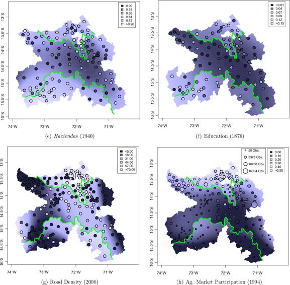
8 TABLE VI LAND TENURE AND LABOR SYSTEMS a Dependent Variable Percent of Haciendas per Rural Tributary Percent of Rural 1000 District Population in Population in Haciendas per Residents Haciendas Haciendas Land Gini District in 1689 in 1689 in ca in 1940 in 1994 (1) (2) (3) (4) (5) Panel A. Cubic Polynomial in Latitude and Longitude Mita *** 6 453** 0 127* (3 221) (2 490) (0 067) (0 086) (0 053) R Panel B. Cubic Polynomial in Distance to Potosí Mita *** 7 570*** 0 204** 0 143*** 0 107*** (2 057) (1 478) (0 082) (0 051) (0 036) R Panel C. Cubic Polynomial in Distance to Mita Boundary Mita *** 8 516*** 0 212*** 0 120*** 0 124*** (2 074) (1 665) (0 060) (0 045) (0 033) R Geo. controls yes yes yes yes yes Boundary F.E.s yes yes yes yes yes Mean dep. var Observations a The unit of observation is the district. Robust standard errors are in parentheses. The dependent variable in column 1 is haciendas per district in 1689 and in column 2 is haciendas per 1000 district residents in 1689 (Villanueva Urteaga (1982)). In column 3 it is the percentage of the district s tributary population residing in haciendas ca (Peralta Ruiz (1991)), in column 4 it is the percentage of the district s rural population residing in haciendas in 1940 (Dirección de Estadística del Perú (1944)), and in column 5 it is the district land gini (INEI (1994)). Panel A includes a cubic polynomial in the latitude and longitude of the observation s district capital, panel B includes a cubic polynomial in Euclidean distance from the observation s district capital to Potosí, and panel C includes a cubic polynomial in Euclidean distance to the nearest point on the mita boundary. All regressions include geographic controls and boundary segment fixed effects. The samples include districts whose capitals are less than 50 km from the mita boundary. Column 3 is weighted by the square root of the district s rural tributary population and column 4 is weighted by the square root of the district s rural population. 58% of the observations are in mita districts in columns 1 and 2, 59% in column 3, 62% in column 4, and 66% in column 5. Coefficients that are significantly different from zero are denoted by the following system: *10%, **5%, and ***1%.
9 TABLE VII EDUCATION a Dependent Variable Mean Years Mean Years Literacy of Schooling of Schooling (1) (2) (3) Panel A. Cubic Polynomial in Latitude and Longitude Mita * (0 012) (0 177) (0 872) R Panel B. Cubic Polynomial in Distance to Potosí Mita 0 020*** 0 181** (0 007) (0 078) (0 451) R Panel C. Cubic Polynomial in Distance to Mita Boundary Mita 0 022*** 0 209*** (0 006) (0 076) (0 429) R Geo. controls yes yes yes Boundary F.E.s yes yes yes Mean dep. var Clusters Observations a The unit of observation is the district in columns 1 and 2 and the individual in column 3. Robust standard errors, adjusted for clustering by district, are in parentheses. The dependent variable is mean literacy in 1876 in column 1 (Dirección de Estadística del Perú (1878)), mean years of schooling in 1940 in column 2 (Dirección de Estadística del Perú (1944)), and individual years of schooling in 2001 in column 3 (ENAHO (2001)). Panel A includes a cubic polynomial in the latitude and longitude of the observation s district capital, panel B includes a cubic polynomial in Euclidean distance from the observation s district capital to Potosí, and panel C includes a cubic polynomial in Euclidean distance to the nearest point on the mita boundary. All regressions include geographic controls and boundary segment fixed effects. The samples include districts whose capitals are less than 50 km from the mita boundary. Columns 1 and 2 are weighted by the square root of the district s population. 64% of the observations are in mita districts in column 1, 63% in column 2, and 67% in column 3. Coefficients that are significantly different from zero are denoted by the following system: *10%, **5%, and ***1%.
10 (A) (B) FIGURE 1. (A) Ethnic boundaries. (B) Ethnic pre-colonial institutions.
11 (A) (B) FIGURE 3. (A) Luminosity at the ethnic homeland. (B) Pixel-level luminosity.
12 TABLE I SUMMARY STATISTICS a Variable Obs. Mean St. Dev. p25 Median p75 Min Max Panel A: All Observations Light Density ln( Light Density) Pixel-Level Light Density 66, Lit Pixel 66, Panel B: Stateless Ethnicities Light Density ln( Light Density) Pixel-Level Light Density 13, Lit Pixel 13, Panel C: Petty Chiefdoms Light Density ln( Light Density) Pixel-Level Light Density 20, Lit Pixel 20, Panel D: Paramount Chiefdoms Light Density ln( Light Density) Pixel-Level Light Density 20, Lit Pixel 20, Panel E: Pre-Colonial States Light Density ln( Light Density) Pixel-Level Light Density 12, Lit Pixel 12, a The table reports descriptive statistics for the luminosity data that we use to proxy economic development at the country-ethnic homeland level and at the pixel level. Panel A gives summary statistics for the full sample. Panel B reports summary statistics for ethnicities that lacked any form of political organization beyond the local level at the time of colonization. Panel C reports summary statistics for ethnicities organized in petty chiefdoms. Panel D reports summary statistics for ethnicities organized in large paramount chiefdoms. Panel E reports summary statistics for ethnicities organized in large centralized states. The classification follows Murdock (1967). The Data Appendix in the Supplemental Material (Michalopoulos and Papaioannou (2013)) gives detailed variable definitions and data sources.
13 TABLE II PRE-COLONIAL ETHNIC INSTITUTIONS AND REGIONAL DEVELOPMENT CROSS-SECTIONAL ESTIMATES a (1) (2) (3) (4) (5) (6) Jurisdictional Hierarchy *** ** *** *** *** *** Double-clustered s.e. (0.1246) (0.1397) (0.1026) (0.0676) (0.0605) (0.0539) Conley s s.e. [0.1294] [0.1288] [0.1014] [0.0646] [0.0599] [0.0545] Rule of Law (in 2007) ** Double-clustered s.e. (0.2213) Conley s s.e. [0.1747] Log GDP p.c. (in 2007) *** Double-clustered s.e. (0.1232) Conley s s.e. [0.1021] Adjusted R-squared Population Density No Yes Yes Yes Yes Yes Location Controls No No Yes Yes Yes Yes Geographic Controls No No No Yes Yes Yes Observations a Table II reports OLS estimates associating regional development with pre-colonial ethnic institutions, as reflected in Murdock s (1967) index of jurisdictional hierarchy beyond the local community. The dependent variable is log( light density at night from satellite) at the ethnicity country level. In column (5) we control for national institutions, augmenting the specification with the rule of law index (in 2007). In column (6) we control for the overall level of economic development, augmenting the specification with the log of per capita GDP (in 2007). In columns (2) (6) we control for log( population density). In columns (3) (6) we control for location, augmenting the specification with distance of the centroid of each ethnicity country area from the respective capital city, distance from the closest sea coast, and distance from the national border. The set of geographic controls in columns (4) (6) includes log(1 + area under water(lakes, rivers, and other streams)), log(surface area), land suitability for agriculture, elevation, a malaria stability index, a diamond mine indicator, and an oil field indicator. The Data Appendix in the Supplemental Material gives detailed variable definitions and data sources. Below the estimates, we report in parentheses double-clustered standard errors at the country and ethnolinguistic family dimensions. We also report in brackets Conley s (1999) standard errors that account for two-dimensional spatial autocorrelation. ***, **, and * indicate statistical significance, with the most conservative standard errors at the 1%, 5%, and 10% level, respectively.
14 TABLE III PRE-COLONIAL ETHNIC INSTITUTIONS AND REGIONAL DEVELOPMENT WITHIN AFRICAN COUNTRIES a (1) (2) (3) (4) (5) (6) (7) (8) (9) (10) (11) (12) Panel A: Pre-Colonial Ethnic Institutions and Regional Development Within African Countries All Observations Jurisdictional *** *** *** *** Hierarchy (0.0851) (0.0852) (0.0553) (0.0501) Binary Political *** *** *** *** Centralization (0.1489) (0.1573) (0.0896) (0.0972) Petty Chiefdoms (0.2105) (0.1736) (0.1540) (0.1216) Paramount Chiefdoms * * ** ** (0.2428) (0.2537) (0.1625) (0.1610) Pre-Colonial States *** *** *** *** (0.2757) (0.2441) (0.1638) (0.1484) Adjusted R-squared Observations Country Fixed Effects Yes Yes Yes Yes Yes Yes Yes Yes Yes Yes Yes Yes Location Controls No Yes No Yes No Yes No Yes No Yes No Yes Geographic Controls No Yes No Yes No Yes No Yes No Yes No Yes Population Density No No Yes Yes No No Yes Yes No No Yes Yes (Continues)
15 TABLE III Continued (1) (2) (3) (4) (5) (6) (7) (8) (9) (10) (11) (12) Panel B: Pre-Colonial Ethnic Institutions and Regional Development Within African Countries Focusing on the Intensive Margin of Luminosity Jurisdictional *** *** ** ** Hierarchy (0.1238) (0.1118) (0.0703) (0.0728) Binary Political ** *** ** ** Centralization (0.2381) (0.2085) (0.1232) (0.1391) Petty Chiefdoms (0.2789) (0.2358) (0.1787) (0.1725) Paramount Chiefdoms * (0.3683) (0.3367) (0.2258) (0.2388) Pre-Colonial States *** *** *** ** (0.3382) (0.3209) (0.2207) (0.2198) Adjusted R-squared Observations Country Fixed Effects Yes Yes Yes Yes Yes Yes Yes Yes Yes Yes Yes Yes Location Controls No Yes No Yes No Yes No Yes No Yes No Yes Geographic Controls No Yes No Yes No Yes No Yes No Yes No Yes Population Density No No Yes Yes No No Yes Yes No No Yes Yes a Table III reports within-country OLS estimates associating regional development with pre-colonial ethnic institutions. In Panel A the dependent variable is thelog( light density at night from satellite) at the ethnicity-country level. In Panel B the dependent variable is the log(light density at night from satellite) at the ethnicity-country level; as such we exclude areas with zero luminosity. In columns (1) (4) we measure pre-colonial ethnic institutions using Murdock s (1967) jurisdictional hierarchy beyond the local community index. In columns (5) (8) we use a binary political centralization index that is based on Murdock s (1967) jurisdictional hierarchy beyond the local community variable. Following Gennaioli and Rainer (2007), this index takes on the value of zero for stateless societies and ethnic groups that were part of petty chiefdoms and 1 otherwise (for ethnicities that were organized as paramount chiefdoms and ethnicities that were part of large states). In columns (9) (12) we augment the specification with three dummy variables that identify petty chiefdoms, paramount chiefdoms, and large states. The omitted category consists of stateless ethnic groups before colonization. All specifications include a set of country fixed effects (constants not reported). In even-numbered columns we control for location and geography. The set of control variables includes the distance of the centroid of each ethnicity-country area from the respective capital city, the distance from the sea coast, the distance from the national border, log(1 + area under water (lakes, rivers, and other streams)), log(surface area), land suitability for agriculture, elevation, a malaria stability index, a diamond mine indicator, and an oil field indicator. The Data Appendix in the Supplemental Material gives detailed variable definitions and data sources. Below the estimates, we report in parentheses double-clustered standard errors at the country and the ethnolinguistic family dimensions. ***, **, and * indicate statistical significance at the 1%, 5%, and 10% level, respectively.
16 TABLE IV EXAMINING THE ROLE OF OTHER PRE-COLONIAL ETHNIC FEATURES a Specification A Specification B Additional Variable Obs. Additional Variable Jurisdictional Hierarchy Obs. (1) (2) (3) (4) (5) Gathering *** 682 (0.1892) (0.1842) (0.0550) Hunting *** 682 (0.1316) (0.1236) (0.0562) Fishing * * *** 682 (0.1271) (0.1267) (0.0551) Animal Husbandry *** 682 (0.0407) (0.0432) (0.0617) Milking *** 680 (0.1463) (0.1443) (0.0581) Agriculture Dependence ** ** *** 682 (0.0468) (0.0454) (0.0558) Agriculture Type *** 680 (0.1043) (0.1021) (0.0549) Polygyny *** 677 (0.1253) (0.1288) (0.0561) Polygyny Alternative *** 682 (0.1560) (0.1479) (0.0543) Clan Communities *** 567 (0.1439) (0.1401) (0.0536) Settlement Pattern *** 679 (0.0361) (0.0377) (0.0571) Complex Settlements *** 679 (0.1604) (0.1606) (0.0553) Hierarchy of Local *** 680 Community (0.0822) (0.0867) (0.0565) Patrilineal Descent *** 671 (0.1329) (0.1307) (0.0499) Class Stratification ** ** 570 (0.0526) (0.0580) (0.0696) Class Stratification Indicator ** ** 570 (0.1863) (0.1896) (0.0562) Elections *** 500 (0.2682) (0.2577) (0.0581) (Continues)
17 TABLE IV Continued Specification A Specification B Additional Variable Obs. Additional Variable Jurisdictional Hierarchy Obs. (1) (2) (3) (4) (5) Slavery *** 610 (0.1487) (0.1580) (0.0617) Inheritance Rules for *** 529 Property Rights (0.2127) (0.2283) (0.0690) a Table IV reports within-country OLS estimates associating regional development with pre-colonial ethnic features as reflected in Murdock s (1967) Ethnographic Atlas. The dependent variable is the log( light density at night from satellite) at the ethnicity-country level. All specifications include a set of country fixed effects (constants not reported). In all specifications we control for log( population density at the ethnicity-country level). In specification A (in columns (1) (2)) we regress log( light density) on various ethnic traits from Murdock (1967). In specification B (columns (3) (5)) we regress log( light density) on each of Murdock s additional variables and the jurisdictional hierarchy beyond the local community index. The Data Appendix in the Supplemental Material gives detailed variable definitions and data sources. Below the estimates, we report in parentheses double-clustered standard errors at the country and the ethnolinguistic family dimensions. ***, **, and * indicate statistical significance at the 1%, 5%, and 10% level, respectively.
18 TABLE V PRE-COLONIAL ETHNIC INSTITUTIONS AND REGIONAL DEVELOPMENT: PIXEL-LEVEL ANALYSIS a Lit/Unlit Pixels ln( Luminosity) (1) (2) (3) (4) (5) (6) (7) (8) (9) (10) Panel A: Jurisdictional Hierarchy Beyond the Local Community Level Jurisdictional Hierarchy ** ** *** *** *** ** ** *** *** *** Double-clustered s.e. (0.0314) (0.0176) (0.0081) (0.0074) (0.0071) (0.1837) (0.1035) (0.0542) (0.0506) (0.0483) Adjusted R-squared Panel B: Pre-Colonial Institutional Arrangements Petty Chiefdoms Double-clustered s.e. (0.0255) (0.0339) (0.0220) (0.0175) (0.0141) (0.1192) (0.1832) (0.1271) (0.0976) (0.0837) Paramount Chiefdoms ** * ** *** ** ** *** Double-clustered s.e. (0.0334) (0.0489) (0.0295) (0.0266) (0.0178) (0.1560) (0.2472) (0.1498) (0.1347) (0.0964) Pre-Colonial States ** ** *** *** *** ** ** *** *** *** Double-clustered s.e. (0.0956) (0.0519) (0.0240) (0.0216) (0.0235) (0.5488) (0.2881) (0.1432) (0.1430) (0.1493) Adjusted R-squared Country Fixed Effects No Yes Yes Yes Yes No Yes Yes Yes Yes Population Density No No Yes Yes Yes No No Yes Yes Yes Controls at the Pixel Level No No No Yes Yes No No No Yes Yes Controls at the No No No No Yes No No No No Yes Ethnic-Country Level Observations 66,570 66,570 66,570 66,173 66,173 66,570 66,570 66,570 66,173 66,173
19 TABLE VII PRE-COLONIAL ETHNIC INSTITUTIONS AND REGIONAL DEVELOPMENT WITHIN CONTIGUOUS ETHNIC HOMELANDS IN THE SAME COUNTRY a Difference in Jurisdictional Hierarchy One Ethnic Group was Part of a All Observations Index > 1 Pre-Colonial State (1) (2) (3) (4) (5) (6) (7) (8) (9) Jurisdictional Hierarchy * ** ** * ** ** ** ** *** Double-clustered s.e. (0.0134) (0.0073) (0.0065) (0.0159) (0.0079) (0.0072) (0.0213) (0.0096) (0.0069) Adjusted R-squared Observations 78,139 78,139 77,833 34,180 34,180 34,030 16,570 16,570 16,474 Adjacent-Ethnic-Groups Fixed Effects Yes Yes Yes Yes Yes Yes Yes Yes Yes Population Density No Yes Yes No Yes Yes No Yes Yes Controls at the Pixel Level No No Yes No No Yes No No Yes a Table VII reports adjacent-ethnicity (ethnic-pair-country) fixed effects OLS estimates associating regional development, as reflected in satellite light density at night with pre-colonial ethnic institutions, as reflected in Murdock s (1967) jurisdictional hierarchy beyond the local community index within pairs of adjacent ethnicities with a different degree of political centralization in the same country. The unit of analysis is a pixel of decimal degrees (around kilometers). Every pixel falls into the historical homeland of ethnicity i in country c that is adjacent to the homeland of another ethnicity j in country c, where the two ethnicities differ in the degree of political centralization. The dependent variable is a dummy variable that takes on the value of 1 if the pixel is lit and zero otherwise. In columns (4) (6) we restrict estimation to adjacent ethnic groups with large differences in the 0 4 jurisdictional hierarchy beyond the local level index (greater than one point). In columns (7) (9) we restrict estimation to adjacent ethnic groups in the same country where one of the two ethnicities was part of a large state before colonization (in this case the jurisdictional hierarchy beyond the local level index equals 3 or 4). In columns (2), (3), (5), (6), (8), and (9) we control for ln(pixel population density). In columns (3), (6), and (9) we control for a set of geographic and location variables at the pixel level. The set of controls includes the distance of the centroid of each pixel from the respective capital, its distance from the sea coast, its distance from the national border, an indicator for pixels that have water (lakes, rivers, and other streams), an indicator for pixels with diamond mines, an indicator for pixels with oil fields, the pixel s land suitability for agriculture, pixel s mean elevation, pixel s average value of a malaria stability index, and the log of the pixel s area. Below the estimates, we report in parentheses double-clustered standard errors at the country and the ethnolinguistic family dimensions. ***, **, and * indicate statistical significance at the 1%, 5%, and 10% level, respectively.
20 (A) (B) FIGURE 5. (A) Border thickness: 0 km. (B) Border thickness: 25 km.
21 TABLE VIII PRE-COLONIAL ETHNIC INSTITUTIONS AND REGIONAL DEVELOPMENT WITHIN ADJACENT ETHNIC HOMELANDS IN THE SAME COUNTRY: CLOSE TO THE ETHNIC BORDER a All Observations Difference in Jurisdictional Hierarchy One Ethnic Group Was Part of a Adjacent Ethnicities in the Same Country Index > 1 Pre-Colonial State < 100 km of < 150 km of < 200 km of < 100 km of < 150 km of < 200 km of < 100 km of < 150 km of < 200 km of ethnic border ethnic border ethnic border ethnic border ethnic border ethnic border ethnic border ethnic border ethnic border (1) (2) (3) (4) (5) (6) (7) (8) (9) Panel A: Pre-Colonial Ethnic Institutions and Regional Development Within Contiguous Ethnic Homelands in the Same Country Pixel-Level Analysis in Areas Close to the Ethnic Border Panel 1: Border Thickness Total 50 km (25 km from each side of the ethnic boundary) Jurisdictional Hierarchy * ** ** *** *** *** *** *** *** Double-clustered s.e. (0.0102) (0.0106) (0.0102) (0.0092) (0.0088) (0.0084) (0.0090) (0.0067) (0.0069) Adjusted R-squared Observations ,451 13, Panel 2: Border Thickness Total 100 km (50 km from each side of the ethnic boundary) Jurisdictional Hierarchy ** ** ** *** *** *** *** *** *** Double-clustered s.e. (0.0114) (0.0117) (0.0108) (0.0094) (0.0083) (0.0076) (0.0092) (0.0057) (0.0068) Adjusted R-squared Observations , (Continues) PRE-COLONIAL INSTITUTIONS AND AFRICAN DEVELOPMENT 145
22 TABLE VI PRE-COLONIAL ETHNIC INSTITUTIONS AND GEOGRAPHIC CHARACTERISTICS WITHIN CONTIGUOUSETHNIC HOMELANDS IN THE SAME COUNTRY a Dependent variable is: Diamond Water Distance to Distance to Distance to Malaria Land Mean Indicator Oil Indicator Indicator the Capital the Sea the Border Stability Suitability Elevation (1) (2) (3) (4) (5) (6) (7) (8) (9) Jurisdictional Hierarchy Double-clustered s.e. (0.0008) (0.0051) (0.0077) ( ) (6.3349) ( ) (0.0181) (0.0060) ( ) Adjusted R-squared Mean of Dependent Variable Observations 78,139 78,139 78,139 78,139 78,139 78,139 77,985 77,983 78,139 Adjacent-Ethnic-Groups Fixed Effects Yes Yes Yes Yes Yes Yes Yes Yes Yes a Table VI reports OLS estimates associating various geographical, ecological, and other characteristics with pre-colonial ethnic institutions within pairs of adjacent ethnicities. The unit of analysis is a pixel of decimal degrees (around kilometers). Every pixel falls into the historical homeland of ethnicity i in country c that is adjacent to the homeland of another ethnicity j in country c, where the two ethnicities differ in the degree of political centralization. The dependent variable in column (1) is a binary index that takes on the value of 1 if there is a diamond mine in the pixel; in column (2) a binary index that takes on the value of 1 if an oil/petroleum field is in the pixel; in column (3) a binary index that takes on the value of 1 if a water body falls in the pixel. In columns (4) (6) the dependent variable is the distance of each pixel from the capital city, the sea coast, and the national border, respectively. In column (7) the dependent variable is the average value of a malaria stability index; in column (8) the dependent variable is land s suitability for agriculture; in column (9) the dependent variable is elevation. The Data Appendix in the Supplemental Material gives detailed variable definitions and data sources. Below the estimates, we report in parentheses double-clustered standard errors at the country and the ethnolinguistic family dimensions. ***, **, and * indicate statistical significance at the 1%, 5%, and 10% level, respectively. PRE-COLONIAL INSTITUTIONS AND AFRICAN DEVELOPMENT 141
Productivity Differences Within and Between Countries
 Productivity Differences Within and Between Countries Melissa Dell MIT OECD Lagging Regions Meeting, June 2010 Dell (MIT) Productivity Differences OECD Lagging Regions 1 / 21 Motivation Introduction and
Appendix - Legal Origins and Female HIV
 Appendix - Legal Origins and Female HIV Siwan Anderson Vancouver School of Economics and CIFAR December 2017 A1. Figures Figure A1 Population Density (people/square km) by Ethnic Group 1 A2. Data Sources
Roots of Autocracy. November 26, 2016
 Roots of Autocracy Oded Galor Marc Klemp November 26, 2016 Abstract This research explores the origins of the variation in the prevalence and nature of political institutions across globe. It advances
Notes On: Do Television and Radio Destroy Social Capital? Evidence from Indonesian Village (Olken 2009)
") Notes On: Do Television and Radio Destroy Social Capital? Evidence from Indonesian Village (Olken 2009) Increasing interest in phenomenon social capital variety of social interactions, networks, and groups
Notes On: Do Television and Radio Destroy Social Capital? Evidence from Indonesian Village (Olken 2009) Increasing interest in phenomenon social capital variety of social interactions, networks, and groups
Questionable Inference on the Power of Pre-Colonial Institutions in Africa
 Questionable Inference on the Power of Pre-Colonial Institutions in Africa Denis Cogneau, Yannick Dupraz To cite this version: Denis Cogneau, Yannick Dupraz. Questionable Inference on the Power of Pre-Colonial
Online Appendix Income Opportunities and Sea Piracy in Indonesia
 Online Appendix Income Opportunities and Sea Piracy in Indonesia Sebastian Axbard List of Tables 1 Labor Market Effects by Lights at Night........... 2 2 Validating Measure of (Additional Specifications)............................
Web Appendix. Dynamics and Stagnation in the Malthusian Epoch
 Web Appendix Dynamics and Stagnation in the Malthusian Epoch Quamrul Ashraf and Oded Galor A Variable Definitions and Sources Population Density in 1 CE, 1000 CE, and 1500 CE: Population density in a given
In contrast to early economics, much of modern economic analysis. today largely ignores geography. Human populations cluster mainly on
 When you can measure what you are speaking about, and express it in numbers, you know something about it; when you cannot measure it, when you cannot express it in numbers, your knowledge is of a meager
Apéndice 1: Figuras y Tablas del Marco Teórico
 Apéndice 1: Figuras y Tablas del Marco Teórico FIGURA A.1.1 Manufacture poles and manufacture regions Poles: Share of employment in manufacture at least 12% and population of 250,000 or more. Regions:
Web Appendix: Temperature Shocks and Economic Growth
 Web Appendix: Temperature Shocks and Economic Growth Appendix I: Climate Data Melissa Dell, Benjamin F. Jones, Benjamin A. Olken Our primary source for climate data is the Terrestrial Air Temperature and
About places and/or important events Landmarks Maps How the land is, hills or flat or mountain range Connected to maps World Different countries
 What do you think you know about geography? About places and/or important events Landmarks Maps How the land is, hills or flat or mountain range Connected to maps World Different countries What do you
Advanced Placement Human Geography
 Advanced Placement Human Geography Introduction to AP Human Geography The Advanced Placement course in Human Geography is designed to introduce students to the systematic study of the processes that have
APPENDIX TABLE 1 Expansion of the National Malaria Control Program Population protected. # Units established (cumulative)
") Appendix A.1. The National Malaria Control Program APPENDIX TABLE 1 Expansion of the National Malaria Control Program Population protected # Units established # Units established (cumulative) (cumulative,
Appendix A.1. The National Malaria Control Program APPENDIX TABLE 1 Expansion of the National Malaria Control Program Population protected # Units established # Units established (cumulative) (cumulative,
LOUISIANA STUDENT STANDARDS FOR SOCIAL STUDIES THAT CORRELATE WITH A FIELD TRIP TO DESTREHAN PLANTATION KINDERGARTEN
 LOUISIANA STUDENT STANDARDS FOR SOCIAL STUDIES THAT CORRELATE WITH A FIELD TRIP TO DESTREHAN PLANTATION KINDERGARTEN Standard 2 Historical Thinking Skills Students distinguish between events, people, and
SUPPLEMENT TO DEMOCRACY, REDISTRIBUTION, AND POLITICAL PARTICIPATION: EVIDENCE FROM SWEDEN (Econometrica, Vol. 82, No. 3, May 2014, )
") Econometrica Supplementary Material SUPPLEMENT TO DEMOCRACY, REDISTRIBUTION, AND POLITICAL PARTICIPATION: EVIDENCE FROM SWEDEN 1919 1938 (Econometrica, Vol. 82, No. 3, May 2014, 961 993) BY BJÖRNTYREFORSHINNERICH
Econometrica Supplementary Material SUPPLEMENT TO DEMOCRACY, REDISTRIBUTION, AND POLITICAL PARTICIPATION: EVIDENCE FROM SWEDEN 1919 1938 (Econometrica, Vol. 82, No. 3, May 2014, 961 993) BY BJÖRNTYREFORSHINNERICH
Politician Family Networks and Electoral Outcomes: Evidence from the Philippines. Online Appendix. Cesi Cruz, Julien Labonne, and Pablo Querubin
 Politician Family Networks and Electoral Outcomes: Evidence from the Philippines Online Appendix Cesi Cruz, Julien Labonne, and Pablo Querubin 1 A.1 Additional Figures 8 4 6 2 Vote Share (residuals) 4
The Origins of Ethnolinguistic Diversity. Stelios Michalopoulos. Web Appendix
 The Origins of Ethnolinguistic Diversity Stelios Michalopoulos Web Appendix Table 1a: Summary Statistics for the Real Country Analysis _stats in in Land Land from East Africa Ln # of Precip. Temp. Sea
Supporting Information
 Supporting Information Das and Vincent 10.1073/pnas.0810440106 Table S1. Definitions and data sources for variables Variable Description Source Human deaths Number of deaths per village during the cyclone
Cities in Bad Shape: Urban Geometry in India
 Cities in Bad Shape: Urban Geometry in India Mariaflavia Harari MIT IGC Cities Research Group Conference 21 May 2015 Introduction Why Study City Shape A wide range of factors determine intra-urban commuting
Globally Estimating the Population Characteristics of Small Geographic Areas. Tom Fitzwater
 Globally Estimating the Population Characteristics of Small Geographic Areas Tom Fitzwater U.S. Census Bureau Population Division What we know 2 Where do people live? Difficult to measure and quantify.
MARS AREA SCHOOL DISTRICT CURRICULUM GRADE: Grade 4
 MARS AREA SCHOOL DISTRICT CURRICULUM GRADE: Grade 4 Course Title: Social Studies Brief Description Overview: Students will explore the history, geography, government, and economy of the United States with
Temperature and Income: Online Appendices
 Temperature and Income: Online Appendices Melissa Dell Massachusetts Institute of Technology Benjamin F. Jones Northwestern University and NBER Benjamin A. Olken Massachusetts Institute of Technology and
Dublin City Schools Social Studies Graded Course of Study Grade 5 K-12 Social Studies Vision
 K-12 Social Studies Vision The Dublin City Schools K-12 Social Studies Education will provide many learning opportunities that will help students to: develop thinking as educated citizens who seek to understand
INDIANA ACADEMIC STANDARDS FOR SOCIAL STUDIES, WORLD GEOGRAPHY. PAGE(S) WHERE TAUGHT (If submission is not a book, cite appropriate location(s))
 WHERE TAUGHT (If submission is not a book, cite appropriate location(s))") Prentice Hall: The Cultural Landscape, An Introduction to Human Geography 2002 Indiana Academic Standards for Social Studies, World Geography (Grades 9-12) STANDARD 1: THE WORLD IN SPATIAL TERMS Students
Prentice Hall: The Cultural Landscape, An Introduction to Human Geography 2002 Indiana Academic Standards for Social Studies, World Geography (Grades 9-12) STANDARD 1: THE WORLD IN SPATIAL TERMS Students
APPENDIX A - Complementary Tables and Additional Results
 APPENDIX A - Complementary Tables and Additional Results Table A1. Summary statistics cities 10,000 inhabitants variable overall (2,597 obs.) Christian (1,940 obs.) Muslim (657 obs.) mean st.dev mean st.dev
Subunit 4.1: 2.5 hours. Subunit 4.2: 2.75 hours. Subunit 4.3: 1.5 hours. Subunit 4.4: 3.5 hours. Subunit 4.5: 1.5 hours Unit 4 Learning Outcomes close
 Unit 4: North America The realm of North America extends from the polar regions of the Arctic in northern Canada and Alaska, all the way south through Mexico and the countries of Central America. Geographers
(1) (2) (3) Baseline (replicated)
 (2) (3) Baseline (replicated)") Table A1: Regressions with nonlinear term and fixed effects (based on baseline specification of Table IV, column 4) (refers to footnotes 42 and 45 in the published paper) (1) (2) (3) Baseline (replicated)
Table A1: Regressions with nonlinear term and fixed effects (based on baseline specification of Table IV, column 4) (refers to footnotes 42 and 45 in the published paper) (1) (2) (3) Baseline (replicated)
Key Issue 1: Where Are Services Distributed? INTRODUCING SERVICES AND SETTLEMENTS LEARNING OUTCOME DESCRIBE THE THREE TYPES OF SERVICES
 Revised 2017 NAME: PERIOD: Rubenstein: The Cultural Landscape (12 th edition) Chapter Twelve Services and Settlements (pages 430 thru 457) This is the primary means by which you will be taking notes this
Minnesota K-12 Academic Standards in Social Studies. Grade 4: Geography of North America
 Minnesota K-12 Academic s in Social Studies Grade 4: Geography of North America 4 Describe how people take 1. Democratic government action to influence a depends on informed and decision on a specific
Table B1. Full Sample Results OLS/Probit
 Table B1. Full Sample Results OLS/Probit School Propensity Score Fixed Effects Matching (1) (2) (3) (4) I. BMI: Levels School 0.351* 0.196* 0.180* 0.392* Breakfast (0.088) (0.054) (0.060) (0.119) School
Building the next generation of global citizens! Curriculum. International Sports Exchange
 Building the next generation of global citizens! Curriculum International Sports Exchange CURRICULUM Unit TItle: SOUTHERN AFRICA Unit Length: Weeks Guiding Questions: Can students locate the region of
Variables and Variable De nitions
 APPENDIX A Variables and Variable De nitions All demographic county-level variables have been drawn directly from the 1970, 1980, and 1990 U.S. Censuses of Population, published by the U.S. Department
D ESK A TLAS.COM MAPS N YSTROM NYSTROM. Name
 MAPS A TLAS.COM Exploring NystromDeskAtlas.com The resources in NystromDeskAtlas.com will help you learn more about our world. The site s maps, graphs, photos, and links offer a wealth of information about
Eastern Hemisphere Geography 7th Grade *Chapters 1-10 covered in 6 th Grade
 Quarter 1 Geography Tools and Concepts Chapters 1-5 Intro to Geography = 2 day review Goal Objective Task Analysis Vocabulary Text Location Goal 2.1: Analyze the 6-9.GEH.2.1.1 Explain and use the Identify
 CSAE WPS/2008-06 1998-2001 panel Mitch panel Mitch panel Mitch panel 1998-2001 panel 1998 1999 2001 Poverty 68.7% 74.1% 73.1% 70.6% 63.6% Extreme Poverty 28.6% 32.0% 34.5% 25.9% 25.4%
AP HUG REVIEW WELCOME TO 2 ND SEMESTER! Annette Parkhurst, M.Ed. January, 2015
 AP HUG REVIEW WELCOME TO 2 ND SEMESTER! Annette Parkhurst, M.Ed. January, 2015 Movement Globalization Latitude & Elevation Levels of Economic Activities CONNECTIONS Human Geography Human is the geography
Sharing the wealth across the urban hierarchy in Sub-Saharan African countries: Resource rents and politics
 Sharing the wealth across the urban hierarchy in Sub-Saharan African countries: Resource rents and politics July 12, 2015 Vernon Henderson (LSE), Adam Storeygard (Tufts) and Jamila Nigmatulina (LSE) Motivation:
AP Human Geography Free Response Questions Categorized
 AP Human Geography Free Response Questions Categorized 2002-2010 2. Population (13-17%) 3. Over the past 150 years, Europe has changed from a source to a destination region for international migration.
GEOGRAPHY POLICY STATEMENT. The study of geography helps our pupils to make sense of the world around them.
 GEOGRAPHY POLICY STATEMENT We believe that the study of geography is concerned with people, place, space and the environment and explores the relationships between the earth and its peoples. The study
Use Eaton Kortum model to look at very cool data
 Railroads of the Raj Dave Donaldson, MIT Impact of transportation on: Prices Welfare Use Eaton Kortum model to look at very cool data Background about RR in India 1860 1870 1880 1890 1900 1910 1920 1930
TYPES OF GOVERNMENTS
 While the terms country, state, and nation are often used interchangeably, there is a difference. A State (note the capital "S") is a self-governing political entity. The term State can be used interchangeably
Operational Definitions of Urban, Rural and Urban Agglomeration for Monitoring Human Settlements
 Operational Definitions of Urban, Rural and Urban Agglomeration for Monitoring Human Settlements By Markandey Rai United Nations Human Settlements Programme PO Box-30030 Nairobi, Kenya Abstract The United
Assessing the Regional Vulnerability of Large Scale Mining in Ghana: An Application of Multi Criteria Analysis
 Assessing the Regional Vulnerability of Large Scale Mining in Ghana: An Application of Multi Criteria Analysis Mukesh Subedee, GISDE 14 Arun Poojary, ES&P 13 Clark University April 29, 2013 Ghana: A case
 Table 1. Answers to income and consumption adequacy questions Percentage of responses: less than adequate more than adequate adequate Total income 68.7% 30.6% 0.7% Food consumption 46.6% 51.4% 2.0% Clothing
Peoples, Places and Cultures in Africa, Asia and the Southwest Pacific
 GRADE 7 Peoples, Places and Cultures in Africa, Asia and the Southwest Pacific Course 0470-07 Students in seventh grade explore the history, geography, government, economic systems, current issues, and
GROWING APART: THE CHANGING FIRM-SIZE WAGE PREMIUM AND ITS INEQUALITY CONSEQUENCES ONLINE APPENDIX
 GROWING APART: THE CHANGING FIRM-SIZE WAGE PREMIUM AND ITS INEQUALITY CONSEQUENCES ONLINE APPENDIX The following document is the online appendix for the paper, Growing Apart: The Changing Firm-Size Wage
The Colonial Origins of French Trade Patterns
 The Colonial Origins of French Trade Patterns Tania Kallab Advisor: Cristina Terra 24 October, 2013 that I. Sommaire Research Question and Motivation Colonialism and Economic Performance (AJR 2001, Alam
SOCIAL STUDIES GRADE 5. I Can Checklist Office of Teaching and Learning Curriculum Division REGIONS AND PEOPLE OF THE WESTERN HEMISPHERE
 SOCIAL STUDIES REGIONS AND PEOPLE OF THE WESTERN HEMISPHERE GRADE 5 I Can Checklist 2015-2016 Aligned with Ohio s Learning Standards for Social Studies Office of Teaching and Learning Curriculum Division
Terrain Analysis through Maps.
 Terrain Analysis through Maps Need for Maps Theodolite Every Inch on Earth is Measured Maps are Prepared based on these Measurements Classification of Maps Function Scale Physical (Natural Features)
Summary Article: Poverty from Encyclopedia of Geography
 Topic Page: Poverty Definition: poverty from Dictionary of Energy Social Issues. the fact of being poor; the absence of wealth. A term with a wide range of interpretations depending on which markers of
Topic 4: Changing cities
 Topic 4: Changing cities Overview of urban patterns and processes 4.1 Urbanisation is a global process a. Contrasting trends in urbanisation over the last 50 years in different parts of the world (developed,
Ninth ARTNeT Capacity Building Workshop for Trade Research "Trade Flows and Trade Policy Analysis"
 Ninth ARTNeT Capacity Building Workshop for Trade Research "Trade Flows and Trade Policy Analysis" June 2013 Bangkok, Thailand Cosimo Beverelli and Rainer Lanz (World Trade Organization) 1 Selected econometric
World Geography. WG.1.1 Explain Earth s grid system and be able to locate places using degrees of latitude and longitude.
 Standard 1: The World in Spatial Terms Students will use maps, globes, atlases, and grid-referenced technologies, such as remote sensing, Geographic Information Systems (GIS), and Global Positioning Systems
DATA DISAGGREGATION BY GEOGRAPHIC
 PROGRAM CYCLE ADS 201 Additional Help DATA DISAGGREGATION BY GEOGRAPHIC LOCATION Introduction This document provides supplemental guidance to ADS 201.3.5.7.G Indicator Disaggregation, and discusses concepts
Mapping Diversity in Old and New Netherland
 Your web browser (Safari 7) is out of date. For more security, comfort and Activityengage the best experience on this site: Update your browser Ignore Mapping Diversity in Old and New Netherland How did
We are learning to describe how geography affected the growth of Mesopotamia.
 Name Team/Rotation Middle East, Past and Present Learning Targets and Success Criteria We are learning to describe how geography affected the growth of Mesopotamia. We are looking for the reasons why rivers
Mutah university faculty of Social Sciences The Study plan of the department of Geography 2006/2007
 Mutah university faculty of Social Sciences The Study plan of the department of Geography 2006/2007 Requirements university compulsory 22 Credit hours Course No Credit hours Prerequisite Requirements Faculty
Spotlight on Population Resources for Geography Teachers. Pat Beeson, Education Services, Australian Bureau of Statistics
 Spotlight on Population Resources for Geography Teachers Pat Beeson, Education Services, Australian Bureau of Statistics Population Population size Distribution Age Structure Ethnic composition Gender
Department of Geography: Vivekananda College for Women. Barisha, Kolkata-8. Syllabus of Post graduate Course in Geography
 India: Regional Problems and Resource management Module 11 (Full Marks 50) Unit I: Region and Regionalisation 1.1 Various bases of regionalisation of India; problems of identification and delineation.
MULTIPLE CHOICE. Choose the one alternative that best completes the statement or answers the question.
 Practice Chapter 1 Exam Name MULTIPLE CHOICE. Choose the one alternative that best completes the statement or answers the question. 1) The historic diffusion of HIV/AIDS in the United States is an example
K- 5 Academic Standards in. Social Studies. June 2013
 K- 5 Academic s in Social Studies June 2013 Word Tables of s ONLY This Word version of the 2.17.12 social studies standards (DRAFT for Rulemaking 2.17.12) document contains the standards ONLY; no explanatory
Year 34 B2 Geography - Continents and Oceans 2018 Key Skills to be covered: Taken from Level 3 Taken from Level 4
 Key Skills to be covered: Taken from Level 3 Taken from Level 4 Geographical Enquiry: I ask, Which PHYSICAL features does this place have? I ask, Which HUMAN features does this place have? I give reasons
AP Human Geography. Nogales High School Class Website: bogoaphuman.weebly.com. Course Description. Unit IV: Political Geography
 1 2 Mrs. Bogosian AP Human Geography Nogales High School 2017-2018 Class Website: bogoaphuman.weebly.com Course Description AP Human Geography is a yearlong course that focuses on the distribution, processes,
3. What is the etymology (how the word came to be) of geography. 4. How does the study of physical geography differ from that of human geography?
 of geography. 4. How does the study of physical geography differ from that of human geography?") AP Human Geography Unit 1: Basic Concepts and Development Guided Reading Mr. Stepek Directions: Follow the common directions distributed to you for guided reading assignments. Rubenstein p 2 5 (Introduction)
AP Human Geography Unit 1: Basic Concepts and Development Guided Reading Mr. Stepek Directions: Follow the common directions distributed to you for guided reading assignments. Rubenstein p 2 5 (Introduction)
Unit 1 Basic Geographical Concepts and Themes of Geography
 Unit 1 Basic Geographical Concepts and Themes of Geography Physical: Mount Everest Political: Nepalese Sherpa What is Geography? -Geography, simply put, is the study of the Earth s surface. This includes
GEORGIA CITIES IN EUROPE AND CENTRAL ASIA METHODOLOGY. Public Disclosure Authorized. Public Disclosure Authorized. Public Disclosure Authorized
 Public Disclosure Authorized Public Disclosure Authorized Public Disclosure Authorized Public Disclosure Authorized CITIES IN EUROPE AND CENTRAL ASIA GEORGIA METHODOLOGY This Country Snapshot was produced
Texas Geography. Understanding the physical and human characteristics of our state
 Texas Geography Understanding the physical and human characteristics of our state To understand Texas you must first learn about its Geography. Geography- The study of the world, its people, and the interaction
Environmental Analysis, Chapter 4 Consequences, and Mitigation
 Environmental Analysis, Chapter 4 4.17 Environmental Justice This section summarizes the potential impacts described in Chapter 3, Transportation Impacts and Mitigation, and other sections of Chapter 4,
NATIONAL SENIOR CERTIFICATE GRADE 12
 NATIONAL SENIOR CERTIFICATE GRADE 12 GEOGRAPHY P1 FEBRUARY/MARCH 2015 MARKS: 225 TIME: 3 hours This question paper consists of 12 pages and an annexure of 12 pages. *GEOGE1* Geography/P1 2 INSTRUCTIONS
Online Robustness Appendix to Endogenous Gentrification and Housing Price Dynamics
 Online Robustness Appendix to Endogenous Gentrification and Housing Price Dynamics Robustness Appendix to Endogenous Gentrification and Housing Price Dynamics This robustness appendix provides a variety
Wednesday, May 23, 2018
 Wednesday, May 23, 2018 Physical Geography of West Africa Objective: Summarize the main geographic aspects of each country in West Africa. Understand each country s development pattern and their current
Announcements. J. Parman (UC-Davis) Analysis of Economic Data, Winter 2011 February 8, / 45
 Analysis of Economic Data, Winter 2011 February 8, / 45") Announcements Solutions to Problem Set 3 are posted Problem Set 4 is posted, It will be graded and is due a week from Friday You already know everything you need to work on Problem Set 4 Professor Miller
Announcements Solutions to Problem Set 3 are posted Problem Set 4 is posted, It will be graded and is due a week from Friday You already know everything you need to work on Problem Set 4 Professor Miller
Spatial patterns of non-agricultural employment growth in rural Mexico during the 90s
 Spatial patterns of non-agricultural employment growth in rural Mexico during the 90s Caridad Araujo, Alain de Janvry and Elisabeth Sadoulet Department of Agricultural and Resource Economics University
GIS in Locating and Explaining Conflict Hotspots in Nepal
 GIS in Locating and Explaining Conflict Hotspots in Nepal Lila Kumar Khatiwada Notre Dame Initiative for Global Development 1 Outline Brief background Use of GIS in conflict study Data source Findings
Grade 4-Social Studies Sparta Area School District
 1 Grade 4-Social Studies Sparta Area School District A.4.1 Use reference points, latitude and longitude, direction, size, shape, and scale to locate positions on various representations of the Earth s
A Meta-Analysis of the Urban Wage Premium
 A Meta-Analysis of the Urban Wage Premium Ayoung Kim Dept. of Agricultural Economics, Purdue University kim1426@purdue.edu November 21, 2014 SHaPE seminar 2014 November 21, 2014 1 / 16 Urban Wage Premium
Grade 4 Benchmarks. Benchmark Concepts Skills Essential Question(s)
") **Be aware of the use of and & or in the benchmark language related to Canada and Mexico; sometimes students may look at the US and one of our neighboring countries and other times students need to study
**Be aware of the use of and & or in the benchmark language related to Canada and Mexico; sometimes students may look at the US and one of our neighboring countries and other times students need to study
Entrepôts and Economic Geography
 Entrepôts and Economic Geography Hugh Montag & Heyu Xiong 6/2/17 Motivation What explains the uneven distribution of economic activities across space? A large empirical literature has emphasized the significance
Spatial Analysis 1. Introduction
 Spatial Analysis 1 Introduction Geo-referenced Data (not any data) x, y coordinates (e.g., lat., long.) ------------------------------------------------------ - Table of Data: Obs. # x y Variables -------------------------------------
Measuring Poverty. Introduction
 Measuring Poverty Introduction To measure something, we need to provide answers to the following basic questions: 1. What are we going to measure? Poverty? So, what is poverty? 2. Who wants to measure
Academic Standards for Geography
 Academic Standards for June 1, 2009 FINAL Elementary Standards Grades 3-8 Pennsylvania Department of Education These standards are offered as a voluntary resource for Pennsylvania s schools and await action
Warmup. geography compass rose culture longitude
 Warmup geography compass rose culture longitude ecosystem latitude 1. study of the special physical and human characteristics of a place or region 2. learned system of shared beliefs, traits, and values
A.P. Human Geography
 A.P. Human Geography 2012-2013 Instructor: Chris Vitt Brief Description of Course AP Human Geography is designed to provide students with a learning experience equivalent to that obtained in most college
Learning Target : Describe the purposes and uses of different types of maps.
 Learning Target : Describe the purposes and uses of different types of maps. Directions: 1. Below, place a where you think you are located. 2. In which continent are you located? 3. In which country are
Pre-Reformation Roots of the Protestant Ethic: Supplementary Material
 Pre-Reformation Roots of the Protestant Ethic: Supplementary Material Thomas Barnebeck Andersen University of Southern Denmark Jeanet Bentzen University of Copenhagen Carl-Johan Dalgaard University of
AP Human Geography Syllabus
 AP Human Geography Syllabus Textbook The Cultural Landscape: An Introduction to Human Geography. Rubenstein, James M. 10 th Edition. Upper Saddle River, N.J.: Prentice Hall 2010 Course Objectives This
Module 10 Summative Assessment
 Module 10 Summative Assessment Activity In this activity you will use the three dimensions of vulnerability that you learned about in this module exposure, sensitivity, and adaptive capacity to assess
CBSE Question Paper 2010 GEOGRAPHY Class XII
 CBSE Question Paper 200 GEOGRAPHY Class XII Time allowed: 3 hours Maximum Marks: 70. Name any two areas of high latitudes in the world, where gathering economic activity is practiced. 2. Name the type
Chapter 6. Fundamentals of GIS-Based Data Analysis for Decision Support. Table 6.1. Spatial Data Transformations by Geospatial Data Types
 Chapter 6 Fundamentals of GIS-Based Data Analysis for Decision Support FROM: Points Lines Polygons Fields Table 6.1. Spatial Data Transformations by Geospatial Data Types TO: Points Lines Polygons Fields
OBESITY AND LOCATION IN MARION COUNTY, INDIANA MIDWEST STUDENT SUMMIT, APRIL Samantha Snyder, Purdue University
 OBESITY AND LOCATION IN MARION COUNTY, INDIANA MIDWEST STUDENT SUMMIT, APRIL 2008 Samantha Snyder, Purdue University Organization Introduction Literature and Motivation Data Geographic Distributions ib
Kuby, Michael, John Harner, and Patricia Gober. Human Geography in Action. 6 th Edition. New York: John Wiley, 2012
 2016-2017 Syllabus AP Human Geography Course Description: AP Human Geography is a yearlong course which focuses on the distribution, processes and effects of human populations on the planet. Units of study
Supplemental Information
 Supplemental Information Rewards for Ratification: Payoffs for Participating in the International Human Rights Regime? Richard Nielsen Assistant Professor, Department of Political Science Massachusetts
Spatial Analyst. By Sumita Rai
 ArcGIS Extentions Spatial Analyst By Sumita Rai Overview What does GIS do? How does GIS work data models Extension to GIS Spatial Analyst Spatial Analyst Tasks & Tools Surface Analysis Surface Creation
The OLS Estimation of a basic gravity model. Dr. Selim Raihan Executive Director, SANEM Professor, Department of Economics, University of Dhaka
 The OLS Estimation of a basic gravity model Dr. Selim Raihan Executive Director, SANEM Professor, Department of Economics, University of Dhaka Contents I. Regression Analysis II. Ordinary Least Square
APPENDIX 1: CONSTRUCTING GINI COEFFICIENTS
 APPENDIX 1: CONSTRUCTING GINI COEFFICIENTS A. Non-parametric estimation of bounds We follow the technique described in Murray (1978) for finding the upper and lower bounds of the Gini from grouped data
Chapter 23. Equatorial Africa
 Chapter 23 Equatorial Africa Section 1 - Physical Geography of Equatorial Africa Landforms Equatorial Africa, or the Heart of Africa, is a tropical subregion located on and near the Equator in Central
History and Social Science: Advanced Placement Human Geography
 History and Social Science: Advanced Placement Human Geography A.P. Human Geography Curriculum for Loudoun County Public Schools Ashburn, Virginia 2016 This curriculum document for Advanced Placement Human
Centerville Jr. High School Curriculum Mapping (7 th Grade Geography) (Mike Day)
 (Mike Day)") Centerville Jr. High School Curriculum Mapping (7 th Grade Geography) (Mike Day) Standard 1 History Students examine the major movements, events and figures that contributed to the development of Africa,
Centerville Jr. High School Curriculum Mapping (7 th Grade Geography) (Mike Day) Standard 1 History Students examine the major movements, events and figures that contributed to the development of Africa,
New National Curriculum Geography Skills Planning KS1
 New National Curriculum Geography Skills Planning KS1 Enquiry Question Objective-essential knowledge skills or understanding Locational Knowledge Standards /Success Criteria Lesson progression over half
Observational Data Standard - List of Entities and Attributes
 OBSERVATION An observation characterizes the occurrence, or documents the lack of occurrence, of an organism or set of organisms through a data collection event at a location. Individual observations are