Application of 2D Electrical Resistivity Imaging Technique for Engineering Site Investigation
|
|
|
- Naomi Goodwin
- 5 years ago
- Views:
Transcription
1 Application of 2D Electrical Resistivity Imaging Technique for Engineering Site Investigation Asem A. Hassan 2 Munther D. AL-Awsi 1 Mutadhid M. Al-Obaidi 3 1 College of Science, Diyala University, Baqubah, Diyala, Iraq, asem.ahmed@sciences.uodiyal.edu.iq 2 College of Science, Diyala University, Baqubah, Diyala, Iraq, munther_hnt@sciences.uodiyala.edu.iq 3 College of Science, Diyala University, Baqubah, Diyala, Iraq, mutadhid@sciences.uodiyal.edu.iq Abstract Engineering site investigation is crucial to characterize the subsurface soil of proposed construction sites. Application of 2D Electrical Resistivity Imaging ERI technique pro- vides useful information about the subsurface geology and the condition along profiles. In this paper, numerical and field studies using 2D ERI technique were adopted for engineer- ing site investigation purposes. The Wenner-Schlumberger array was implemented along three parallel profiles at the construction site of Diyala University, northeast of Baghdad city, to detect buried utilities (pipes) left over in the area. A synthetic resistivity model of a buried pipe was designed to discuss and validate the field results. The 2D ERI sections of the model resolve clearly the buried structure, even with 5% noise level. Interpretation of the field data showed that 2D ERI technique was effective in delineating the buried pipes. The vertical and horizontal sensitivity of the Wenner-Schlumberger array for sub- surface resistivity variations made it possible to determine the position and geometry of the buried structures. The current work demonstrates the usefulness of the ERI technique as a complementary tool for engineering site investigation. Keywords: Electrical Resistivity Imaging, Engineering Site Investigation 74
2 1 -Introduction Engineering site investigation provides a critical geotechnical and geoenvironmental as- sessment of the proposed construction sites. It includes detailed surface and subsurface studies to evaluate the suitability of the site for particular infrastructures. Application of ERI survey for geotechnical site characterization is useful to determine the subsurface geology and the condition of the proposed site [1]. Recently, ERI technique has increasingly been integrated with geotechnical site investigations [2] [3] [4]. It offers non-invasive and cost effective information to identify the subsurface condition and to determine the appropriate location of test borings needed for site investigation [5]. Presence of natural (e.g. Cavities and sinkholes) and man- made (e.g. Pipes and channels) structures in the engineering construction sites brings significant geotechnical and geoenvironmental problems. The determination of these structures is important to facilitate the proposed construction site with respect to the shallow and deep foundations. Traditional ground-truth test borings are commonly implemented for geotechnical site investigations. However, these methods are expensive and limited to a point [3]. In comparison, 2D ERI surveys are less expensive and can be conducted along profiles to obtain 2D resistivity sections [6]. Several authors have adopted 2D ERI technique for engineering site investigation to detect subsurface structures such as cavities and sinkholes [7] [8] [9] [10] [11] [12], fractures [13] [14], faults [15], buried utilities [16], walls [17], cracks [18] and tunnels [19]. Recently, an extensive campaign of building of new facilities has taken place in Diyala University northeast of Baghdad city. Delineation of buried utilities and construction materials left over in the area is vital to facilitate the site for future engineering projects [20]. Thus, in this study, numerical and field studies are adopted to detect buried utilities (pipes) 75
3 in the construction site of Diyala University. The resistivity measurements are collected using Wenner-Schlumberger array along three parallel profiles. A synthetic resistivity model is designed to discuss and validate the interpretation of the field data. 2-2D Electrical Resistivity Imaging Technique 2D Electrical Resistivity Imaging ERI technique is based on using a larger num- ber of electrodes arranged along a profile and connected to the electrical resistiv- ity system via a multi core cable [21]. The apparent resistivity measurements of Wenner- Schlumberger array, adopted in the current study, are acquired using cur- rent (C1 and C2) and voltage (P1 and P2) electrodes for different electrode spacing (a) and acquisition levels (n) Figure (1). The Wenner-Schlumberger array is a hy- brid combination between Wenner and Schlumberger arrays. It was chosen as it has good signal strength and sensitivity to resolve horizontal and vertical resistivity variations [22].The subsurface resistivity values acquired are arranged in apparent resistivity pseudo-sections which give a qualitative approximations of the subsurface resistivity distribution. An inversion procedure, therefore, is required to obtain a true 2D resistivity section from the field data. 3 -Field Work 2D ERI survey using a Wenner-Schlumberger array was conducted along three parallel profiles, 1m apart, located in Diyala University, northeast of Baghdad city Figure (2). According to the geotechnical soil borings drilled in the area [3] the surface soil consists 76

. Geotechnical site investigation is necessary to explore the subsurface condition and to locate buried")
4 of light to dark brown low plasticity clay (CL) layer up to 13m Figure (3). The study area has recently witnessed an extensive expansion campaign of building new teaching facilities. Presence of buried structures such as pipes and construction materials left over in the area are expected Figure (4). Geotechnical site investigation is necessary to explore the subsurface condition and to locate buried structures for future engineering projects. 77

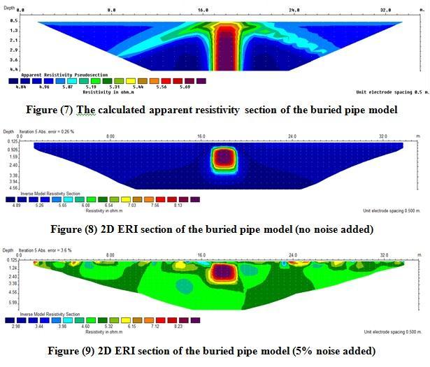
5 2D ERI profiles were centered over an existing buried pipe to investigate the suitability of the Wenner-Schlumberger array for delineating shallow buried (pipes) structures. For each profile, twenty electrodes with a minimum electrode spacing of 0.5m was connected to ABEM SAS 4000 resistivity system to collect the apparent resistivity data. RES2DINV software ver [23] was used to generate 2D ERI sections from the apparent resistivity data. RES2DINV uses finite difference method based on the regularized least squares optimization procedure [24] [23] to produce a true 2D model of the subsurface resistivity distribution from the apparent resistivity data. The software iteratively determines the model blocks resistivity that will closely produce the measured apparent resistivity data. The software offers L1 norm (Blocky) and L2 norm (smooth) optimization methods. In the current study, the L1 norm optimization method was adopted as it is more suitable in areas of sharp resistivity boundaries [25], such as buried pipes investigated. 4 -Numerical Modelling Numerical modelling using synthetic resistivity model was used to simulate the buried pipes in the study area. ERI numerical modelling is useful to examine the method adopted and to validate the interpretation of the field data. The procedure consists of two steps [26] : (1) a synthetic resistivity model is designed based on the user prior information using forward modelling software from which the apparent resistivity section is calculated; (2) the model is then inverted to reconstruct the subsurface true resistivity distribution Figure (5). To simulate the buried pipes in the study area, a synthetic resistivity model of a buried pipe in clay soil Figure (6) was designed and discretized using RES2DMOD software ver [27]. An air filled pipe of high resistivity (10000 Ohm.m), buried in a wet clay soil of low resistivity (5.0 Ohm.m) was examined. The resistivity values of the model components were chosen within the range of the materials reported in the literature [28]. The apparent resistivity section for Wenner-Schlumberger array with smallest electrode spacing of 0.5m was first calculated using RES2DMOD software. To simulate real situations, 78

6 a scattered 5% noise value was added to the model. Once the apparent resistivity sections are calculated, RES2DINV ver software was used to produce the inverse 2D ERI sections of the model from the apparent resistivity data. 5 -Discussion and Discussion Figure (7) shows the calculated apparent resistivity section of the synthetic resistivity model. Although the resistivity signature of the buried pipe is indicated, the apparent resistivity section gives a qualitative interpretation of subsurface resistivity variations. Figure (8) presents the 2D ERI section calculated from the apparent resistivity data with no noise added. It can be seen that the buried pipe is clearly reflected in the section at the center of the profile. The high resistivity contrast between the modelled pipe and the sur- rounding medium made it easy to resolve the sharp resistivity variations. To simulate real situations, a scattered 5% noise value was added to the model. Figure (9) depicts the 2D ERI section of model with 5% noise level. The modelled object can still be resolved. The 79

7 Interpretation of the synthetic resistivity model demonstrates the effectiveness of 2D ERI methods using Wenner-Schlumberger array to detect the buried pipes in clay soil. In the literature, recent studies have reported the efficiency of the Wenner- Schlumberger array for resolving buried structures such as fractures and cavities [9] [11] ; buried utilities [16] and buried walls [17]. Field resistivity measurements were conducted along three profiles using the same array. For each profile, a minimum electrode spacing of 0.5m was used and the resistivity readings were collected for 7 (n) acquisition levels. Figure (10) shows the arrangement of model blocks and apparent resistivity data points of the field data. High data quality was achieved as shown in Figure (11). Therefore, there is no need to exterminate bad data points. The 2D ERI sections were calculated from apparent resistivity using L1 norm (blocky) optimization method. Figures (12), (13), and (14) present the 2D ERI sections of the field data along L1, L2, and L3 profiles, respectively. A low (Abs.) error ( %) was achieved after five iterations which indicates a good data quality. It can be seen that the buried pipe at the center of the resistivity profile was resolved reasonably well in all the 2D ERI sections. The geometry and position of the buried pipe were reflected in these sections. 2D ERI sections of the field data confirmed the previous findings of the synthetic 80
8 81

9 Resistivity model. The Wenner-Schlumberger array of the three profiles was succeeded in detecting the buried pipe. The high performance of the Wenner- Schlumberger array can be attributed to its characteristic features and sensitivity for detecting subsurface resistivity variations. It has good signal strength and moderate features that compromise between the ability to resolve horizontal and vertical resistivity variations [22]. 82

10 6 - Conclusions 2D ERI survey was carried out using a Wenner-Schlumberger array along three parallel profiles to detect buried pipes at Diyala University site northeast of Baghdad city. The results of field data were validated using a synthetic resistivity model. Both numerical and field data interpretations indicated that the 2D ERI technique was effective in re- solving the buried structure. Geometry and position of the buried pipe were reasonably reflected in the 2D ERI sections. The results showed that the Wenner- Schlumberger array was sensitive enough to the horizontal and lateral resistivity changes in the subsurface soil resulted due to presence of the buried structure. The current study demonstrated the benefits of numerical modelling using 2D ERI technique for planning of resistivity field surveys. The results also indicated that 2D ERI method can be useful if integrated with other geotechnical site investigation tools to detect buried pipes commonly found in the engineering construction sites. References [1] H. H. Karim, M. A. Al-Neami, and W. M. Y. Mohammad, Soil Site Investigations Using 2D Resistivity Imaging Technique, Eng, [2] E. Elawadi, G. El-Qady, A. Nigm, F. Shaaban, and K. Ushijima, Integrated geophysical survey for site investigation at a new dwelling area, egypt, Jour. Env. & Eng. Geophy, vol. 11, no. 4, pp , [3] Al-Ebdaa, Soil investigation report for the new buildings of diyala university part, p. 210, [4] K. Sudha, M. Israil, S. Mittal, and J. Rai, Soil characterization using electrical resistivity tomography and geotechnical investigations, Journal of Applied Geophysics, Elsevier, vol. 67, pp , [5] A. M. Youssef, H. El-Kaliouby, and Y. A. Zabramawi, Sinkhole detection using electrical resistivity tomography in saudi arabia, Journal of Geophysics and Engineering, vol. 9, no. 6, p. 663,
11 [6] M. H. Loke, J. E. Chambers, D. F. Rucker, O. Kuras, and P. B. Wilkinson, Recent developments in the direct-current geoelectrical imaging method, Journal of Applied Geophysics, 95, vol. pp:, pp , [7] M. V. Schoor, Detection of sinkholes using 2d electrical resistivity imaging.journal, of Applied Geophysics, vol. 50, no. 4, pp , [8] W. Zhou, B. F. Beck, and A. L. Adams, Effective electrode array in mapping karst hazards in electrical resistivity tomography, Environmental geology, vol. 42, no. 8, pp , [9] M. A. Metwaly and F., Application of 2-d geoelectrical resistivity tomography for subsurface cavity detection in the eastern part of saudi arabia, Geoscience Frontiers, vol. 4, no. 4, pp , [10] T. J.M. and A. M. Abed, Detection of subsurface cavities by using pole- dipole array (bristow s method)/hit area-western iraq, Iraqi Journal of Science, vol. 55, no. 2, pp , [11] J. M. Thabit and A. S. Al-Zubedi, Evaluation of three important electrode arrays in defining the vertical and horizontal structures in 2d imaging surveys, Iraqi Journal of Science, vol. 2015, no. 56, pp , [12] A. A. Amini and H. Ramazi, Crsp, numerical results for an electrical resistivity array to detect underground cavities, Open Geosci, vol. 9, pp , [13] S. W.J. and B. T.J, Evaluation of two-dimensional resistivity methods in a fractured crystalline rock terrane, Journal of Applied Geophysics, vol. 51, pp , [14] R. E. Chávez, C.-N. G., A. Tejero, J. E. Hernández-Quintero, and D. Vargas, Special 3D electric resistivity tomography (ERT) array applied to detect buried fractures on urban areas, San, [15] F. Nguyen, S. Garambois, D. Jongmans, E. Pirard, and M. H. Loke, Image processing of 2d resistivity data for imaging faults, J Appl. Geophys. 57, vol. pp:, pp , [16] H. H. Karim, K. H. Ibrahim, and A. H. Al-Rubaye, Detection of buried utilities using electrical resistivity imaging (eri) technique, eng, &Tech. Journal, vol. 33, 2015, part (A), No.3. [17] A. S. Al-Zubedi, Evaluation of five electrode arrays in imaging subsurface shallow targets: A case study, iraqi bulletin of geology and, [18] A. A. Hassan and M. D. Nsaif, Application of 2d electrical resistivity imaging technique for detecting soil cracks: Laboratory study, Iraqi Journal of Science, vol. 2016, no. 57, pp ,
12 [19] M. Ebrahimi, A. A. Taleshi, A. Arab-Amiri, and M. Abbasinia, Two and Three- Dimonsional ERT Modelling for a Buried Tunnnel, 2016, vol. 7, no. 3. [20] Al-Ebdaa, Soil investigation report for the new buildings of diyala university part, p. 210, [21] M. H. Loke, J. E. Chambers, and O. Kuras, Instrumentation, electrical resistivity, solid earth geophysics encyclopedia (2nd, pp , [22] A. Samouëlian, I. Cousin, A. Tabbagh, A. Bruand, and G. Richard, Electrical resistivity survey in soil science: A review, soil tillage, [23] M. H. Loke, Res2dinv ver. 3.71: Rapid 2-d resistivity & ip inversion using the least-squares method. geotomo software, [24] Y. Sasaki, Two-dimensional joint inversion of magnetotelluric and dipole-dipole resistivity data, Geophysics, vol. 54, pp , [25] M. H. Loke, I. Acworth, and D. T., A comparison of smooth and blocky inversion methods in 2d electrical imaging surveys, Exploration Geophysics, vol. 34, pp , [26] P. Giao, Q. N. Cuong, and M. H. Loke, Monitoring the chemical grouting in sandy soil by electrical resistivity tomography (ERT), Berichte Geol, B.-A, [27] M. H. Loke, Res2dmod ver. 3.01: Rapid 2d resistivity forward modeling using the finite-difference and finite-element methods, geotomo software, [28], Tutorial: 2-d and 3-d electrical imaging surveys, geotomo software,
Hamed Aber 1 : Islamic Azad University, Science and Research branch, Tehran, Iran. Mir Sattar Meshin chi asl 2 :
 Present a Proper Pattern for Choose Best Electrode Array Based on Geological Structure Investigating in Geoelectrical Tomography, in order to Get the Highest Resolution Image of the Subsurface Hamed Aber
CHARACTERIZATION OF SOIL PROFILE OF DHAKA CITY USING ELECTRICAL RESISTIVITY TOMOGRAPHY (ERT)
") CHARACTERIZATION OF SOIL PROFILE OF DHAKA CITY USING ELECTRICAL RESISTIVITY TOMOGRAPHY (ERT) Mehedi Ahmed ANSARY 1, B.S. Pushpendue BISWAS 2 and Abul KHAIR 3 1 Professor, Department of Civil Engineering
CHARACTERIZATION OF SOIL PROFILE OF DHAKA CITY USING ELECTRICAL RESISTIVITY TOMOGRAPHY (ERT) Mehedi Ahmed ANSARY 1, B.S. Pushpendue BISWAS 2 and Abul KHAIR 3 1 Professor, Department of Civil Engineering
A Case Study of High-Resolution Gravity and Wenner-Schlumberger Resistivity for Geotechnical Engineering: An Example from North Jordan
 Research Journal of Applied Sciences, Engineering and Technology 5(4): 1377-1382-, 2013 ISSN: 2040-7459; e-issn: 2040-7467 Maxwell Scientific Organization, 2013 Submitted: July 09, 2012 Accepted: August
ACCURATE SUBSURFACE CHARACTERIZATION FOR HIGHWAY APPLICATIONS USING RESISTIVITY INVERSION METHODS
 ACCURATE SUBSURFACE CHARACTERIZATION FOR HIGHWAY APPLICATIONS USING RESISTIVITY INVERSION METHODS Ioannis F. Louis 1, Filippos I. Louis 2 and Melanie Bastou 3 1 Geophysics & Geothermic Division, Geology
KARST MAPPING WITH GEOPHYSICS AT MYSTERY CAVE STATE PARK, MINNESOTA
 KARST MAPPING WITH GEOPHYSICS AT MYSTERY CAVE STATE PARK, MINNESOTA By Todd A. Petersen and James A. Berg Geophysics Program Ground Water and Climatology Section DNR Waters June 2001 1.0 Summary A new
2-D Resistivity Study: The Horizontal Resolution Improvement by Introducing the Enhancing Horizontal Resolution (EHR) Technique
 Technique") Open Journal of Geology, 213, 3, 1-6 doi:1.4236/ojg.213.32b1 Published Online April 213 (http://www.scirp.org/journal/ojg) 2-D Resistivity Study: The Horizontal Resolution Improvement by Introducing the
Open Journal of Geology, 213, 3, 1-6 doi:1.4236/ojg.213.32b1 Published Online April 213 (http://www.scirp.org/journal/ojg) 2-D Resistivity Study: The Horizontal Resolution Improvement by Introducing the
Two and Three-Dimonsional ERT Modelling for a Buried Tunnnel
 Journal of Emerging Trends in Engineering and Applied Sciences (JETEAS) 7(3): 118-127 Scholarlink Research Institute Journals, 2016 (ISSN: 2141-7016) jeteas.scholarlinkresearch.com Journal of Emerging
2-D Resistivity Imaging in Taiping, Perak, Malaysia
 2-D Resistivity Imaging in Taiping, Perak, Malaysia A. I. Rosli *,1, M. A. Mohamed Zawawi 1, H. Juahir 2, N. Z. Karim 3 and N. F. Yusof 1 1 Department of Biological and Agricultural Engineering, Faculty
GPR profiling and electrical resistivity tomography for buried cavity detection: a test site at the Abbaye de l'ouye (France)
") GPR profiling and electrical resistivity tomography for buried cavity detection: a test site at the Abbaye de l'ouye (France) Nerouz BOUBAKI, Albane SAINTENOY, Piotr TUCHOLKA IDES - UMR 8148 CNRS, Université
GPR profiling and electrical resistivity tomography for buried cavity detection: a test site at the Abbaye de l'ouye (France) Nerouz BOUBAKI, Albane SAINTENOY, Piotr TUCHOLKA IDES - UMR 8148 CNRS, Université
1. Resistivity of rocks
 RESISTIVITY 1) Resistivity of rocks 2) General principles of resistivity surveying 3) Field procedures, interpretation and examples 4) Summary and conclusions INDUCED POLARIZATION 1) General principles
High Resolution Time-domain Induced Polarization Tomography with Merging Data Levels by Two Different Optimized Arrays for Slope Monitoring Study
 High Resolution Time-domain Induced Polarization Tomography with Merging Data Levels by Two Different Optimized Arrays for Slope Monitoring Study Andy A. Bery Geophysics Section, School of Physics, Universiti
The three-year mapping and monitoring of underground cavity expansion with 2D resistivity survey: What has revealed?
 The three-year mapping and monitoring of underground cavity expansion with 2D resistivity survey: What has revealed? Peangta Satarugsa 1, Winit Youngmee 1 and Suvijuk Meesawat 1 1. Department of Geotechnology,
IMAGING OF DEEP SINKHOLES USING THE MULTI-ELECTRODE RESISTIVITY IMPLANT TECHNIQUE (MERIT) CASE STUDIES IN FLORIDA
 CASE STUDIES IN FLORIDA") IMAGING OF DEEP SINKHOLES USING THE MULTI-ELECTRODE RESISTIVITY IMPLANT TECHNIQUE (MERIT) CASE STUDIES IN FLORIDA David Harro The G3 Group, 2509 Success Drive, Suite 1, Odessa, FL 33556, david.harro@geo3group.com
IMAGING OF DEEP SINKHOLES USING THE MULTI-ELECTRODE RESISTIVITY IMPLANT TECHNIQUE (MERIT) CASE STUDIES IN FLORIDA David Harro The G3 Group, 2509 Success Drive, Suite 1, Odessa, FL 33556, david.harro@geo3group.com
NGU Report Resistivity Modelling of Fracture Zones and Horizontal Layers in Bedrock.
 NGU Report 2009.070 Resistivity Modelling of Fracture Zones and Horizontal Layers in Bedrock. Geological Survey of Norway NO-7491 Trondheim, Norway Tel.: 47 73 90 40 00 Telefax 47 73 92 16 20 REPORT Report
CONTENTS 1. INTRODUCTION. 2. THE D.C. RESISTIVITY METHOD 2.1 Equipment 2.2 Survey Procedure 2.3 Data Reduction
 (i) CONTENTS 1. INTRODUCTION page 1 2. THE D.C. RESISTIVITY METHOD 2.1 Equipment 2.2 Survey Procedure 2.3 Data Reduction 3 3 3 3 3. GEOPHYSICAL RESULTS 3.1 General 3.2 Discussion 4 4 4 4. LIMITATIONS 5
Integrated site investigation of shallow bedrock sites for seismic site response study
 Southern Cross University epublications@scu 23rd Australasian Conference on the Mechanics of Structures and Materials 2014 Integrated site investigation of shallow bedrock sites for seismic site response
Anomaly effects of arrays for 3d geoelectrical resistivity imaging using orthogonal or parallel 2d profiles
 African Journal of Environmental Science and Technology Vol. 4(7), pp. 446-454, July 2010 Available online at http://www.academicjournals.org/ajest ISSN 1991-637X 2010 Academic Journals Full Length Research
Geoelectrical characterization for liquefaction at coastal zone in South Aceh
 Geoelectrical characterization for liquefaction at coastal zone in South Aceh Muhammad Syukri Laboratory of Geophysics, Department of Physics, Faculty of Mathematic and Sciences, Syiah Kuala University.
Investigation of shallow leakage zones in a small embankment dam using repeated resistivity measurements
 Investigation of shallow leakage zones in a small embankment dam using repeated resistivity measurements Pontus Sjödahl 1, Sam Johansson 2, Torleif Dahlin 3 Resistivity measurements were carried out in
The Efficacy of Enhancing Horizontal Resolution (EHR) Technique in Shallow Subsurface Study Using 2D Resistivity Method at Bukit Bunuh
 Technique in Shallow Subsurface Study Using 2D Resistivity Method at Bukit Bunuh") 212 International Conference on Geological and Environmental Sciences IPCBEE vol.3 6(212) (212)IACSIT Press, Singapoore The Efficacy of Enhancing Horizontal Resolution (EHR) Technique in Shallow Subsurface
212 International Conference on Geological and Environmental Sciences IPCBEE vol.3 6(212) (212)IACSIT Press, Singapoore The Efficacy of Enhancing Horizontal Resolution (EHR) Technique in Shallow Subsurface
APPLICATION OF RESISTIVITY SURVEY TO INVESTIGATE SINKHOLE AND KARST FEATURES IN SOUTHERN THAILAND : A CASE STUDY OF PAKJAM AREA
 GEOTHAI 07 International Conference on Geology of Thailand: Towards Sustainable Development and Sufficiency Economy APPLICATION OF RESISTIVITY SURVEY TO INVESTIGATE SINKHOLE AND KARST FEATURES IN SOUTHERN
Two-dimensional imaging properties of DC geoelectric arrays using numerical and analogue modelling
 PhD Thesis Summary Two-dimensional imaging properties of DC geoelectric arrays using numerical and analogue modelling Szokoli Kitti Sopron 2016 Kitaibel Pál PhD School in Environmental Science Programme
LIST OF FIGURES APPENDICES
 RESISTIVITY / INDUCED POLARIZATION SURVEY EL PORVENIR PROJECT MUNICIPALITY OF REMEDIOS, ANTIOQUIA, COLOMBIA LOGISTICS REPORT M-17427 APRIL 2017 TABLE OF CONTENTS Abstract... 1 1. The Mandate... 2 2. El
SOIL PROFILE IDENTIFICATION AROUND NECATIBEY SUBWAY STATION (ANKARA, TURKEY), USING ELECTRICAL RESISTIVITY IMAGING (ERI)
, USING ELECTRICAL RESISTIVITY IMAGING (ERI)") International Journal of Engineering & Applied Sciences (IJEAS) Vol.4, Issue 4(2012)1-14 SOIL PROFILE IDENTIFICATION AROUND NECATIBEY SUBWAY STATION (ANKARA, TURKEY), USING ELECTRICAL RESISTIVITY IMAGING
International Journal of Engineering & Applied Sciences (IJEAS) Vol.4, Issue 4(2012)1-14 SOIL PROFILE IDENTIFICATION AROUND NECATIBEY SUBWAY STATION (ANKARA, TURKEY), USING ELECTRICAL RESISTIVITY IMAGING
Sensors & Transducers 2015 by IFSA Publishing, S. L.
 Sensors & Transducers, Vol. 87, Issue 4, April 05, pp. 39-43 Sensors & Transducers 05 by IFSA Publishing, S. L. http://www.sensorsportal.com Characteriations of Soil Profiles through Electric Resistivity
Geophysics for Environmental and Geotechnical Applications
 Geophysics for Environmental and Geotechnical Applications Dr. Katherine Grote University of Wisconsin Eau Claire Why Use Geophysics? Improve the quality of site characterization (higher resolution and
Scholars Research Library
 Available online at www.scholarsresearchlibrary.com Scholars Research Library Archives of Physics Research, 2010, 1 (2):37-45 (http://scholarsresearchlibrary.com/archive.html) ISSN 0976-0970 2-D Resistivity
Application of 2D Electrical Resistivity Imaging Technique for Detecting Soil Cracks: Laboratory Study
 Application of 2D Electrical Resistivity Imaging Technique for Detecting Soil Cracks: Laboratory Study Asem Ahmed Hassan*, Mundher Dhahir Nsaif Department of Petroleum and Minerals Geology, College of
Integration of Seismic Refraction and 2D Electrical Resistivity in Locating Geological Contact
 Open Journal of Geology, 2013, 3, 7-12 doi:10.4236/ojg.2013.32b002 Published Online April 2013 (http://www.scirp.org/journal/ojg) Integration of Seismic Refraction and 2D Electrical Resistivity in Locating
Characterization of the geology and subsurface crystalline limestone mining using 2D ERI at Puthur Mines, Tirunelveli, Tamilnadu
 Available online at www.scholarsresearchlibrary.com Archives of Applied Science Research, 2012, 4 (3):1261-1265 (http://scholarsresearchlibrary.com/archive.html) ISSN 0975-508X CODEN (USA) AASRC9 Characterization
Geophysical investigation for shallow subsurface geotechnical problems for eastern part of 15P City, Cairo, Egypt.
 P May IJISET - International Journal of Innovative Science, Engineering & Technology, Vol. 3 Issue 7, July 2016 Geophysical investigation for shallow subsurface th geotechnical problems for eastern part
Mo P 14 Resistivity Modeling of Sinkholes Effects Caused by Karst and Suffosion
 Mo P 14 Resistivity Modeling of Sinkholes Effects Caused by Karst and Suffosion P. Cuevas Castellanos (Universidad Autónoma de Nuevo León Facultad de Cie), V.A. Shevnin* (Moscow State University), K.V.
APPLICATION OF ELECTRICAL RESISTIVITY TOMOGRAPHY FOR SAND UNDERWATER EXTRACTION
 International Scientific Conference GEOBALCANICA 2018 APPLICATION OF ELECTRICAL RESISTIVITY TOMOGRAPHY FOR SAND UNDERWATER EXTRACTION Maya Grigorova Ivaylo Koprev University of Mining and Geology St. Ivan
Soil Mechanics and Foundation Engineering, Vol. 53, No. 1, March, 2016 (Russian Original No. 1, January-February, 2016)
") Soil Mechanics and Foundation Engineering, Vol. 53, No. 1, March, 2016 (Russian Original No. 1, January-February, 2016) SLOPE MONITORING STUDY USING SOIL MECHANICS PROPERTIES AND 4-D ELECTRICAL RESISTIVITY
Soil Mechanics and Foundation Engineering, Vol. 53, No. 1, March, 2016 (Russian Original No. 1, January-February, 2016) SLOPE MONITORING STUDY USING SOIL MECHANICS PROPERTIES AND 4-D ELECTRICAL RESISTIVITY
Case Study: Shallow Subsurface Geology Mapping Using 2-D Resistivity Imaging with EHR Technique
 Available online at www.sciencedirect.com APCBEE Procedia 5 (213 ) 134 14 ICESD 213: January 19-2, Dubai, UAE Case Study: Shallow Subsurface Geology Mapping Using 2-D Resistivity Imaging with EHR Technique
An Assessment of Electrical Resistivity Soundings Data by Different Interpretation Techniques
 International Journal of Biological, Ecological and Environmental Sciences (IJBEES) Vol. 1, No. 3, 212 ISSN 2277 4394 An Assessment of Electrical Resistivity Soundings Data by Different Interpretation
Geophysical Investigation of Foundation Condition of A Site in Ikere- Ekiti, Ekiti State, South-Western Nigeria
 Australian Journal of Basic and Applied Sciences, 5(9): 1852-1857, 2011 ISSN 1991-8178 Geophysical Investigation of Foundation Condition of A Site in Ikere- Ekiti, Ekiti State, South-Western Nigeria 1
M. Cushing 1, A. Revil 2,3, C.. Gélis 1, D. Jougnot 3, F. Lemeille 1, J. Cabrera 1, A. De Hoyos 1, M. Rocher 1. Introduction
 RESISTIVITY SURVEY AIMING AT IDENTIFYING HYDROGEOLOGICALLY ACTIVE ZONES IN LIMESTONE AND CLAY FORMATIONS: APPLICATION TO THE TOURNEMIRE EXPERIMENTAL STATION (AVEYRON, FRANCE). M. Cushing 1, A. Revil 2,3,
A case study of crystalline limestone intrusion and fault zone identication using 2d eri technique in Ramco cements, pandalgudi mines, Tamilnadu
 International Research Journal of Geology and Mining (IRJGM) (2276-6618) Vol. 2 (1) pp. 011-015, January 2012 Available online http://www.interesjournals.org/irjgm Copyright 2012 International Research
Electrical imaging techniques for hydrological and risk assessment studies
 Séminaire IPG le 9 mars 2006 Strasbourg Institute of Geophysics ETH Hoenggerberg CH-8093 Zurich Electrical imaging techniques for hydrological and risk assessment studies Laurent Marescot laurent@aug.ig.erdw.ethz.ch
Engineering Site Characterisation Using 2-D and 3-D Electrical Resistivity Tomography
 Earth Science Research; Vol. 2, No. 1; 2013 ISSN 1927-0542 E-ISSN 1927-0550 Published by Canadian Center of Science and Education Engineering Site Characterisation Using 2-D and 3-D Electrical Resistivity
3D Electrical Resistivity Tomography (ERT) Survey of a Typical Basement Complex Terrain
 Survey of a Typical Basement Complex Terrain") Journal of Emerging Trends in Engineering and Applied Sciences (JETEAS) 2 (4): 680-686 Scholarlink Research Institute Journals, 2011 (ISSN: 2141-7016) jeteas.scholarlinkresearch.org Journal of Emerging
Journal of Emerging Trends in Engineering and Applied Sciences (JETEAS) 2 (4): 680-686 Scholarlink Research Institute Journals, 2011 (ISSN: 2141-7016) jeteas.scholarlinkresearch.org Journal of Emerging
Geophysical techniques for investigating shallow and deep landslides: results in the framework of PREVIEW project (FP6 UE)
") Geophysical techniques for investigating shallow and deep landslides: results in the framework of PREVIEW project (FP6 UE) Perrone, A; Piscitelli, S; Lampenna, V; Lamporte, A; Giocolli, A; Dahlin, Torleif
Geophysical techniques for investigating shallow and deep landslides: results in the framework of PREVIEW project (FP6 UE) Perrone, A; Piscitelli, S; Lampenna, V; Lamporte, A; Giocolli, A; Dahlin, Torleif
FINAL REPORT GEOPHYSICAL INVESTIGATION VILLAGE ALHAMBRA RETENTION POND SITE THE VILLAGES, FLORIDA
 FINAL REPORT GEOPHYSICAL INVESTIGATION VILLAGE ALHAMBRA RETENTION POND SITE THE VILLAGES, FLORIDA Prepared for Andreyev Engineering, Inc. Oxford, FL Prepared by GeoView, Inc. St. Petersburg, FL August
Resolution of 3-D Electrical Resistivity Images from Inversions of 2-D Orthogonal Lines
 339 Resolution of 3-D Electrical Resistivity Images from Inversions of 2-D Orthogonal Lines Dr. Mehran Gharibi* 1 and Dr. Laurence R. Bentley 2 1 Researcher, Department of Geology & Geophysics, University
Subsurface Characterization using Electrical Resistivity(Dipole-Dipole) method at Lagos State University (LASU) Foundation School, Badagry
 method at Lagos State University (LASU) Foundation School, Badagry") Available online at www.pelagiaresearchlibrary.com Advances in Applied Science Research, 2010, 1 (1): 174-181 Subsurface Characterization using Electrical Resistivity(Dipole-Dipole) method at Lagos State
Available online at www.pelagiaresearchlibrary.com Advances in Applied Science Research, 2010, 1 (1): 174-181 Subsurface Characterization using Electrical Resistivity(Dipole-Dipole) method at Lagos State
ΟΡΥΚΤΟΣ ΠΛΟΥΤΟΣ/MINERAL WEALTH
 Geophysics FAULT PRESENCE UNDER A FAILING BUILDING COMPLEX MAPPED BY ELECTRICAL RESISTIVITY TOMOGRAPHY A.F. FOLORUNSO 1 * E.A. AYOLABI 2 S.O. ARIYO 3 I.O. OYEBANJO 3 Abstract An electrical resistivity
Relevance of 2D Electrical Imaging in Subsurface Mapping: Case Study of National Animal Production Research Institute (NAPRI), Zaria.
, Zaria.") Relevance of 2D Electrical Imaging in Subsurface Mapping: Case Study of National Animal Production Research Institute (NAPRI), Zaria. S.I. Fadele, Ph.D. (in view) 1* ; J. Adamu, M.Sc. 2 ; N.O. Patrick,
Relevance of 2D Electrical Imaging in Subsurface Mapping: Case Study of National Animal Production Research Institute (NAPRI), Zaria. S.I. Fadele, Ph.D. (in view) 1* ; J. Adamu, M.Sc. 2 ; N.O. Patrick,
Comparison of an optimized resistivity array with dipole-dipole soundings in karst terrain
 GEOPHYSICS, VOL. 7, NO. JULY-AUGUST 7 ; P. F19 F1, 8 FIGS. 1.119/1.799 Comparison of an optimized resistivity array with dipole-dipole soundings in karst terrain Jonathan E. Nyquist 1, John S. Peake, and
Electrical prospecting involves detection of surface effects produced by electrical current flow in the ground.
 Electrical Surveys in Geophysics Electrical prospecting involves detection of surface effects produced by electrical current flow in the ground. Electrical resistivity method Induced polarization (IP)
GEOPHYSICAL SITE CHARACTERIZATION IN SUPPORT OF HIGHWAY EXPANSION PROJECT
 GEOPHYSICAL SITE CHARACTERIZATION IN SUPPORT OF HIGHWAY EXPANSION PROJECT * Shane Hickman, * Todd Lippincott, * Steve Cardimona, * Neil Anderson, and + Tim Newton * The University of Missouri-Rolla Department
Geoelectrical and IP Imaging Used for Pre-investigation at a Tunnel Project. Danielsen, Berit Ensted; Arver, Henrik; Karlsson, T; Dahlin, Torleif
 Geoelectrical and IP Imaging Used for Pre-investigation at a Tunnel Project Danielsen, Berit Ensted; Arver, Henrik; Karlsson, T; Dahlin, Torleif 2008 Link to publication Citation for published version
Azimuthal Resistivity to Characterize Fractures in a Glacial Till. Mark Boris, University of Saskatchewan Jim Merriam, University of Saskatchewan
 Azimuthal Resistivity to Characterize Fractures in a Glacial Till Mark Boris, University of Saskatchewan Jim Merriam, University of Saskatchewan Abstract Azimuthal resistivity was used to characterize
Groundwater Sustainability at Wadi Al Bih Dam, Ras El Khaimah, United Arab Emirates (UAE) using Geophysical methods
 using Geophysical methods") Groundwater Sustainability at Wadi Al Bih Dam, Ras El Khaimah, United Arab Emirates (UAE) using Geophysical methods Ahmed Murad, Amir Gabr, Saber Mahmoud, Hasan Arman & Abdulla Al Dhuhoori Geology Department
Groundwater Sustainability at Wadi Al Bih Dam, Ras El Khaimah, United Arab Emirates (UAE) using Geophysical methods Ahmed Murad, Amir Gabr, Saber Mahmoud, Hasan Arman & Abdulla Al Dhuhoori Geology Department
Combination of ID laterally constrained inversion and smooth inversion of resistivity data with a priori data from boreholes
 Combination of ID laterally constrained inversion and smooth inversion of resistivity data with a priori data from boreholes Wisén, Roger; Auken, E; Dahlin, Torleif Published in: Near Surface Geophysics
Geophysical Investigation of the Old Gaborone Dumpsite, Botswana SHEMANG, E M; MOLWALEFHE, L; CHAOKA, TR; MOSWEU E; NONDO, M
 JASEM ISSN 1119-8362 All rights reserved Full-text Available Online at www.bioline.org.br/ja J. Appl. Sci. Environ. Mgt. September, 2006 Vol. 10 (3) 87-92 Geophysical Investigation of the Old Gaborone
2-D GEOELECTRICAL SURVEY FOR THE PRELIMINARY ROUTE OF THE NATURAL GAS PIPELINE INSTALLATION AT ALISTRATI CAVES, N. GREECE 1 INTRODUCTION
 ελτίο της Ελληνικής Γεωλογικής Εταιρίας τοµ. XXXVI, 24 Πρακτικά 1 ου ιεθνούς Συνεδρίου, Θεσ/νίκη Απρίλιος 24 Bulletin of the Geological Society of Greece vol. XXXVI, 24 Proceedings of the 1 th International
CORRELATION ANALYSIS BETWEEN FIELD ELECTRICAL RESISTIVITY VALUE (ERV) AND BASIC GEOTECHNICAL PROPERTIES (BGP)
 AND BASIC GEOTECHNICAL PROPERTIES (BGP)") Soil Mechanics and Foundation Engineering, Vol. 5, No. 3, July, 0 (Russian Original No. 3, May-June, 0) CORRELATION ANALYSIS BETWEEN FIELD ELECTRICAL RESISTIVITY VALUE (ERV) AND BASIC GEOTECHNICAL PROPERTIES
Soil Mechanics and Foundation Engineering, Vol. 5, No. 3, July, 0 (Russian Original No. 3, May-June, 0) CORRELATION ANALYSIS BETWEEN FIELD ELECTRICAL RESISTIVITY VALUE (ERV) AND BASIC GEOTECHNICAL PROPERTIES
We 21 C15 Geophysical Investigation for an Assessment of Sinkhole Risk in Schleswig-Holstein/Northern Germany
 We 21 C15 Geophysical Investigation for an Assessment of Sinkhole Risk in Schleswig-Holstein/Northern Germany R. Kirsch* (LLUR-SH), H. Wiederhold (LIAG), W. Rabbel (CAU), E. Erkul (CAU), C. Thomsen (LLUR-SH),
Use of 2D Multi Electrodes Resistivity Imagining for Sinkholes Hazard Assessment along the Eastern Part of the Dead Sea, Jordan
 American Journal of Environmental Sciences 3 (4): 230-234, 2007 ISSN 1553-345X 2007 Science Publications Use of 2D Multi Electrodes Resistivity Imagining for Sinkholes Hazard Assessment along the Eastern
Resistivity survey at Stora Uppåkra, Sweden
 Resistivity survey at Stora Uppåkra, Sweden Dahlin, Torleif Published in: Uppåkra - Centrum i analys och rapport 2001 Link to publication Citation for published version (APA): Dahlin, T. (2001). Resistivity
ELECTRICAL RESISTIVITY SURVEYS AT THE ANDERSON RESIDENCE SITE, PORT CLYDE, ME. For: St.Germain-Collins
 ELECTRICAL RESISTIVITY SURVEYS AT THE ANDERSON RESIDENCE SITE, PORT CLYDE, ME For: St.Germain-Collins 4 Union Street, Suite 3 Bangor, Maine 441 July, 218 ELECTRICAL RESISTIVITY SURVEYS AT THE ANDERSON
GEOELECTRICAL STUDY FOR DELINEATING UNDERGROUND CAVITIES IN KARST AREAS
 GEOELECTRICAL STUDY FOR DELINEATING UNDERGROUND CAVITIES IN KARST AREAS Vl a d Rădulescu (1), Fl o r i a n Rădulescu (2), Co n s t a nt i n Diacopolos (3), Ma r i a n Popescu (3) (1) National Institute
DESICCATION CRACKING DETECTION USING 2-D AND 3-D ELECTRICAL RESISTIVITY TOMOGRAPHY: VALIDATION ON A FLOOD EMBANKMENT.
 DESICCATION CRACKING DETECTION USING 2-D AND 3-D ELECTRICAL RESISTIVITY TOMOGRAPHY: VALIDATION ON A FLOOD EMBANKMENT. Gareth Jones a, Philippe Sentenac a, Marcin Zielinski a,b AFFILIATIONS: a Department
PROCEEDING, SEMINAR NASIONAL KEBUMIAN KE-8 Academia-Industry Linkage OKTOBER 2015; GRHA SABHA PRAMANA
 INCORPORATION OF ELECTRICAL RESISTIVITY TOMOGRAPHY (ERT) DATA IN GEOLOGICAL MODELLING AS METHOD TO INCREASE MODEL ACCURACY IN UNSERPENTINISED ULTRAMAFIC HOSTED NICKEL LATERITE DEPOSIT Budhi Kumarawarman
Imaging subsurface fracture characteristics using 2D electrical resistivity tomography
 International Research Journal of Engineering Science, Technology and Innovation (IRJESTI) Vol. 1(4) pp. 103-110, July 2012 Available online http://www.interesjournals.org/irjesti Copyright 2012 International
APPLICATION OF ELECTRICAL RESISTIVITY IMAGING TECHNIQUE IN THE STUDY OF SLOPE STABILITY IN BANDING ISLAND, PERAK
 313 APPLICATION OF ELECTRICAL RESISTIVITY IMAGING TECHNIQUE IN THE STUDY OF SLOPE STABILITY IN BANDING ISLAND, PERAK Siti Aishah Ismail*, Shaharin Ibrahim M.Sc (GS20247) 4 th Semester Introduction Landslides
Available online Journal of Scientific and Engineering Research, 2018, 5(10): Research Article
: Research Article") Available online www.jsaer.com, 2018, 5(10):179-184 Research Article ISSN: 2394-2630 CODEN(USA): JSERBR The Investigation of the Connection between the Historical Excavation Site and the Historical Fountain
Available online www.jsaer.com, 2018, 5(10):179-184 Research Article ISSN: 2394-2630 CODEN(USA): JSERBR The Investigation of the Connection between the Historical Excavation Site and the Historical Fountain
Applied Geophysics for Environmental Site Characterization and Remediation
 Applied Geophysics for Environmental Site Characterization and Remediation MSECA Webinar September 24, 2015 John Mundell, P.E., L.P.G. Ryan Brumbaugh, L.P.G. MUNDELL & ASSOCIATES, INC. Webinar Objective
Standard, random, and optimum array conversions from two-pole resistance data.
 1 2 3 4 5 6 7 8 9 10 11 12 13 14 15 16 17 18 19 20 21 22 23 24 25 26 27 28 29 30 31 32 33 34 35 36 37 38 39 40 41 Standard, random, and optimum array conversions from two-pole resistance data 1 Dale F.
Elijah Adebowale Ayolabi, Ph.D. 1, Adetayo Femi Folorunso, M.Sc. 2*, Ayodele Franklin Eleyinmi, B.Sc. 1, and Esther O. Anuyah, B.Sc.
 Applications of 1D and 2D Electrical Resistivity Methods to Map Aquifers in a Complex Geologic Terrain of Foursquare Camp, Ajebo, Southwestern Nigeria. Elijah Adebowale Ayolabi, Ph.D. 1, Adetayo Femi Folorunso,
Geophysical Investigation: A Case Study of Basement Complex, Nigeria
 Geophysical Investigation: A Case Study of Basement Complex, Nigeria Adiela U.P 1, Ayodele Moses Oyewole 2 and Omoirabor Omoleomo 3 1 Department of Petroleum Engineering, Nigerian Agip Oil Company, Port
2-D RESISTIVITY IMAGING SURVEY FOR WATER-SUPPLY TUBE WELLS IN A BASEMENT COMPLEX: A CASE STUDY OF OOU CAMPUS, AGO-IWOYE SW NIGERIA
 2-D RESISTIVITY IMAGING SURVEY FOR WATER-SUPPLY TUBE WELLS IN A BASEMENT COMPLEX: A CASE STUDY OF OOU CAMPUS, AGO-IWOYE SW NIGERIA 1 AYOLABI, Elijah Adebowale. 2 FOLORUNSO, Adetayo Femi. and 3 ARIYO, Stephen
ISSN Detection of surface water leakage through limestone cracks, using near surface geophysical techniques. Tharwat H.
 Detection of surface water leakage through limestone cracks, using near surface geophysical techniques. Abstract Tharwat H. Abdelhafeez Geology Department, Al-Azhar University, Cairo, Egypt. Tharwat_geophysics@yahoo.com
MOUNT POLLEY MINING CORPORATION TECHNICAL REPORT ON MULTI-ELECTRODE RESISTIVITY AND SEISMIC REFRACTION SURVEYS MOUNT POLLEY TAILINGS DAM PROJECT
 MOUNT PLEY MINING CORPORATION TECHNICAL REPORT ON MULTI-ELECTRODE RESISTIVITY AND SEISMIC REFRACTION SURVEYS MOUNT PLEY TAILINGS DAM PROJECT LIKELY, B.C. by Claudia Krumbiegel, M.Sc. Cliff Candy, P.Geo.
C18 Hydrogeophysical Monitoring of Landslide Processes Using Automated Time-Lapse Electrical Resistivity Tomography (ALERT)
") C18 Hydrogeophysical Monitoring of Landslide Processes Using Automated Time-Lapse Electrical Resistivity Tomography (ALERT) J.E. Chambers* (British Geological Survey), P.I. Meldrum (British Geological
C18 Hydrogeophysical Monitoring of Landslide Processes Using Automated Time-Lapse Electrical Resistivity Tomography (ALERT) J.E. Chambers* (British Geological Survey), P.I. Meldrum (British Geological
Geophysical Assessment of Subsurface Soil Conditions Using Capacitively Coupled Resistivity
 University of Arkansas, Fayetteville ScholarWorks@UARK Theses and Dissertations 8-2018 Geophysical Assessment of Subsurface Soil Conditions Using Capacitively Coupled Resistivity Folaseye Coker University
SEISMIC RADAR AND ELECTRICAL TECHNIQUES FOR WASTE DISPOSAL ASSESSMENT. M. Pipan, G. Dal Moro, E. Forte & M. Sugan
 SEISMIC RADAR AND ELECTRICAL TECHNIQUES FOR WASTE DISPOSAL ASSESSMENT M. Pipan, G. Dal Moro, E. Forte & M. Sugan Department of Geological, Environmental and Marine Sciences, University of Trieste Via Weiss,
Lima Project: Seismic Refraction and Resistivity Survey. Alten du Plessis Global Geophysical
 Lima Project: Seismic Refraction and Resistivity Survey Alten du Plessis Global Geophysical Report no 0706/2006 18 December 2006 Lima Project: Seismic Refraction and Resistivity Survey by Alten du Plessis
18577 Repeated Electrical Resistivity Tomographies in a CALM Site in Livingston Island, Maritime Antarctica
 18577 Repeated Electrical Resistivity Tomographies in a CALM Site in Livingston Island, Maritime Antarctica A.M. Correia* (Evora University), J. Rocha (Evora University) & G. Vieira (University of Lisbon)
Coal Layer Identification using Electrical Resistivity Imaging Method in Sinjai Area South Sulawesi
 Journal of Physics: Conference Series PAPER OPEN ACCESS Coal Layer Identification using Electrical Resistivity Imaging Method in Sinjai Area South Sulawesi To cite this article: Andi Ilham Samanlangi 2018
Groundwater Exploration In Parts Of Mangu- Halle North-Central Nigeria.
 International Journal of Scientific and Research Publications, Volume 7, Issue 10, October 2017 440 Groundwater Exploration In Parts Of Mangu- Halle North-Central Nigeria. I. Mamuda *, P.M. Akushai **
Abdul Rahim Samsudin, Bahaa-eldin Elwali A.Rahim, Wan Zuhairi Wan Yaacob & Umar Hamzah
 Journal of Spatial Hydrology Vol.6, No.2 Fall 2006 Mapping of contamination plumes at municipal solid waste disposal sites using geoelectric imaging technique: Case studies in Malaysia Abdul Rahim Samsudin,
First Technical Report Geophysical experiments near Kajiado town
 First Technical Report Geophysical experiments near Kajiado town Synthesis Report of First case study within the ISGEAG VIA Water project By: Michel Groen *), Harry Rolf **), and Ammon Muiti ***) *) Acacia
Development of geophysical investigation for verifying treatment efficiency of underground cavities
 Development of geophysical investigation for verifying treatment efficiency of underground cavities Hasan A. Kamal* Kuwait Institute for Scientific Research, Infrastructure Risk and Reliability Program,
2D Resistivity Imaging Investigation of Solid Waste Landfill Sites in Ikhueniro Municipality, Ikpoba Okha Local Government Area,Edo State, Nigeria.
 2D Resistivity Imaging Investigation of Solid Waste Landfill Sites in Ikhueniro Municipality, Ikpoba Okha Local Government Area,Edo State, Nigeria. Iyoha. A, Akhirevbulu O.E, Amadasun C.V.O and Evboumwan
Groundwater Level Monitoring of the Quaternary Aquifer at Al Ain City, United Arab Emirates (UAE) using Geophysical Methods
 using Geophysical Methods") Groundwater Level Monitoring of the Quaternary Aquifer at Al Ain City, United Arab Emirates (UAE) using Geophysical Methods Ahmed Murad & Amir Gabr Geology Department UAE University Outlines Introduction
Groundwater Level Monitoring of the Quaternary Aquifer at Al Ain City, United Arab Emirates (UAE) using Geophysical Methods Ahmed Murad & Amir Gabr Geology Department UAE University Outlines Introduction
B7 Applications of DC resistivity exploration
 B7 Applications of DC resistivity exploration Modern DC resistivity surveys collect data for generating a 2-D or 3-D geoelectric model of the Earth. A simple 1-D analysis does not often yield results that
Electrical Resistivity Survey for Delineating Seawater Intrusion in a Coastal Aquifer
 Electrical Resistivity Survey for Delineating Seawater Intrusion in a Coastal Aquifer Sung-Ho Song*, Gyu-Sang Lee*, Jin-Sung Kim*, Baekuk Seong*, Young-gyu Kim*, Myung-Ha Woo* and Namsik Park** Abstract
Geophysics Course Introduction to DC Resistivity
 NORAD supported project in MRRD covering Capacity Building and Institutional Cooperation in the field of Hydrogeology for Faryab Province Afghanistan Geophysics Course Introduction to DC Resistivity By
RESISTIVITY IMAGING AND BOREHOLE INVESTIGATION OF THE BANTING AREA AQUIFER, SELANGOR, MALAYSIA. A.N. Ibrahim Z.Z.T. Harith M.N.M.
 JOURNAL OF ENVIRONMENTAL HYDROLOGY The Electronic Journal of the International Association for Environmental Hydrology On the World Wide Web at http://www.hydroweb.com VOLUME 11 2003 RESISTIVITY IMAGING
Palaeoscars and landslide prediction using 2D ERI techniques in Ooty area, Nilgiri district, Tamilnadu
 Available online at www.scholarsresearchlibrary.com Archives of Applied Science Research, 2012, 4 (1):262-268 (http://scholarsresearchlibrary.com/archive.html) ISSN 0975-508X CODEN (USA) AASRC9 Palaeoscars
Correlation of Resistivity Value with Geotechnical N-Value of Sedimentary Area in Nusajaya, Johor, Malaysia
 Journal of Physics: Conference Series PAPER OPEN ACCESS Correlation of Resistivity Value with Geotechnical N-Value of Sedimentary Area in Nusajaya, Johor, Malaysia To cite this article: S N Mohd Akip Tan
TWO DIMENSIONAL ELECTRICAL IMAGING OF THE SUBSURFACE STRUCTURE OF BOMO DAM ZARIA, KADUNA STATE NORTH CENTRAL NIGERIA
 TWO DIMENSIONAL ELECTRICAL IMAGING OF THE SUBSURFACE STRUCTURE OF BOMO DAM ZARIA, KADUNA STATE NORTH CENTRAL NIGERIA Felix O. Ojo, Department of Geology, Ekiti State University, Ado-Ekiti, Nigeria. Oladimeji
We N Geophysical Near-surface Characterization for Static Corrections: Multi-physics Survey in Reggane Field, Algeria
 We N114 01 Geophysical Near-surface Characterization for Static Corrections: Multi-physics Survey in Reggane Field, Algeria A. Pineda* (Repsol), S. Gallo (CGG) & H. Harkas (GRN Sonatrach) SUMMARY We are
High Resolution Time-lapse Resistivity Tomography with Merging Data Levels by Two Different Optimized Resistivity Arrays for Slope Monitoring Study
 High Resolution Time-lapse Resistivity Tomography with Merging Data Levels by Two Different Optimized Resistivity Arrays for Slope Monitoring Study Andy A. Bery* Geophysics Section, School of Physics,
USE OF GEOPHYSICAL SURVEYS FOR FILL CHARACTERIZATION AND QUANTITY ESTIMATION AT BROWNFIELD SITES A CASE HISTORY. Abstract
 USE OF GEOPHYSICAL SURVEYS FOR FILL CHARACTERIZATION AND QUANTITY ESTIMATION AT BROWNFIELD SITES A CASE HISTORY John A. Mundell, Mundell & Associates, Inc., Indianapolis, IN Gregory B. Byer, Mundell &
Geophysics Course Interpreting DC Resistivity Data
 NORAD supported project in MRRD covering Capacity Building and Institutional Cooperation in the field of Hydrogeology for Faryab Province Afghanistan Geophysics Course Interpreting DC Resistivity Data
JJEES Jordan Journal of Earth and Environmental Sciences
 JJEES Jordan Journal of Earth and Environmental Sciences Volume 8, (Number 1), Sept, 2017 ISSN 1995-6681 Pages 27-34 Electrical Resistivity Tomography Modeling of Vertical Lithological Contact using Different
The Effect of 2-D Resistivity on Magnetic Field
 The Effect of 2-D Resistivity on Magnetic Field M.M. Nordiana 1, Umi Maslinda 2, Hazrul Hisham 2, M.K.A. Nuramalina 2 1 Geophysics Lecturer, Geophysics Section, School of Physics, 11800 Universiti Sains