Dewatering Effects of Underground Mining
|
|
|
- Christopher Griffith
- 5 years ago
- Views:
Transcription

1 Dewatering Effects of Underground Mining 1
2 Important Factors to be Considered Type of mining: First mining (room and pillar) High extrac>on (e.g., 2 nd, retreat, and longwalling) Overburden thickness Shallow (< 300 feet) Deep (> 300 feet) Overburden lithology Sandstone- rich strata Clay- rich strata Fractures and Faults main avenue of groundwater flow 2
3 Room and Pillar Mining Rule- of- thumb is if 50% or less of the coal is removed, subsidence will not occur in the foreseeable future (Peng, 2006). If subsidence does not occur, the impacts to overlying aquifers and/or streams is generally an>cipated to negligible. There are known excep>ons to this rule Overburden is very thin (<150 to 200 feet). Highly fractured and faulted sandstones. In- mine condi>ons: pillar failure, roof falls, etc. 3

4 Room and Pillar Mining 4

5 Rela7vely thin overburden of predominantly fractured sandstone can dewater overlying units as well as effect stream dewatering, even with 1 st mining only and less than a 50% extrac7on rate. 5

6 Pillar Failure Floor crack (parallel to the rib) caused by floor heaving created by pillar punching. 6

7 Roof falls beneath streams are not unexpected. 7
8 Thin Overburden With less than 150 to 200 feet of overburden, the stress- relief fracture system strongly comes into play (Ferguson, 1967; 1974). There can be a direct hydrologic connec>on of the mine to the shallow aquifers and ul>mately overlying surface water systems. A large amount of sandstone vs. shale and other clay- rich strata will facilitate this hydrologic interac>on. Other in- mine reac>ons can also come into play. And other fracture types that can extend to greater depths (Phillipson and Tyrna, 2002). 8

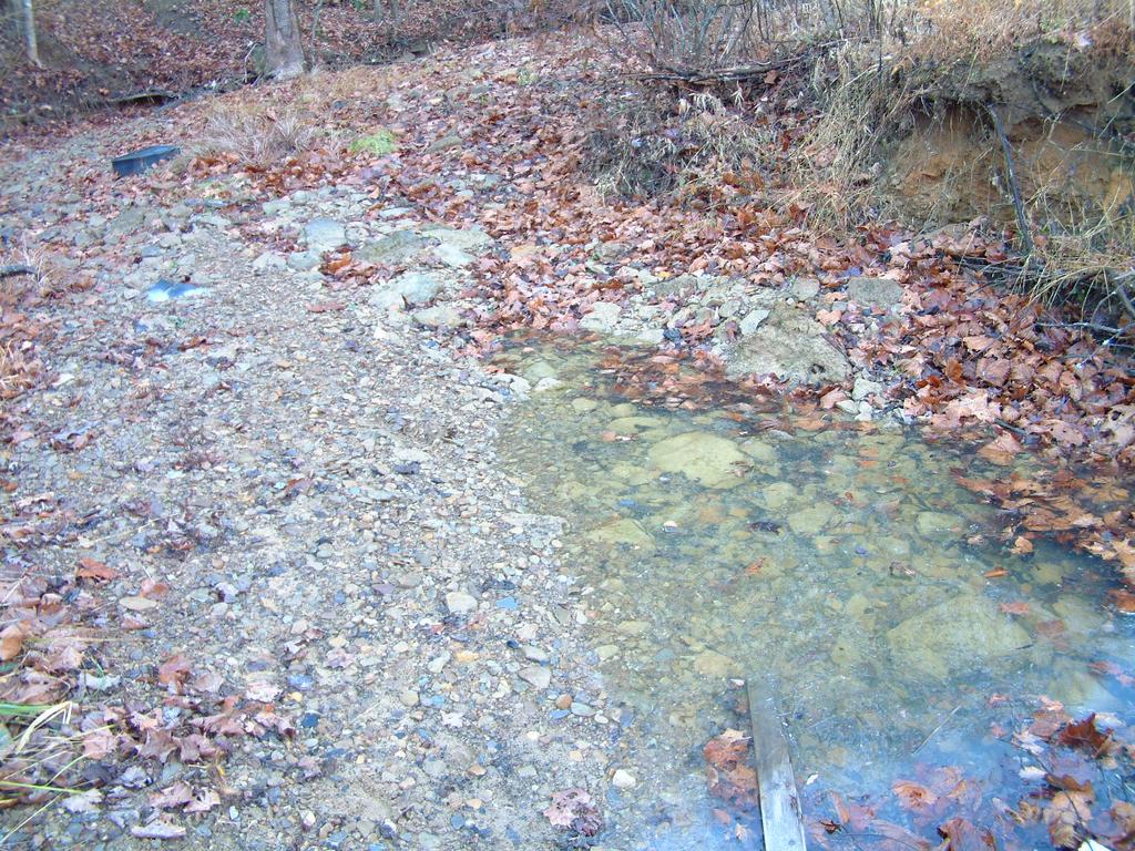
9 Example of Stream Loss Over A Shallow Cover Underground Mine 9

10 Fracture Flow of Ground Water Fracture Flow of Groundwater 10 After Ferguson (1974)
11 Stress- Relief Fractures Fractures are more frequent in the near surface and decrease with increasing depth. Fracture apertures tend to be more open at shallow depths and >ghter the deeper you go. Shales tend to have higher frequency of fracturing than sandstones. But, the fractures in shales tend to be >ghter than those found in sandstones. Literature: Wyrick and Borchers, Wright, Harlow and LeCain, etc. 11
12 General Example Lithologic Impacts Mines in southern West Virginia tend to have mostly sandstone overburden and even at considerable depths (>300 ) they see substan>al inflow from shallow aquifers and overlying streams. Avg. > 0.5 gpm/ac. Whereas, mines in southwestern Pennsylvania tend to have substan>al amounts of clay- rich rocks (shales, siltstones, and claystones) and at considerable depths (>300 ) they make substan>ally less water and any stream dewatering is a near- surface issue. Avg. inflow < 0.1 gpm/ac., one sec>on receives < 0.01 gpm/ac. 12
")
13 Large Land ( Mountain ) Crack 13
14 High- Extrac>on Mining Hydrologic impacts can occur at much greater depths. Mining- induced fracturing from subsidence extends upward toward the surface can intersect the stress- relief fractures. Overburden lithology s>ll influences the degree and scope of impacts. The impacts of the subsidence may be visible at the surface. 14
15 Subsurface and Surface Hydrologic Impacts Impacts to deeper and regional aquifers. Dewatering of shallow aquifers and/or lowering of the water level in these units. Interac>on of shallow aquifers and surface water bodies. Stream dewatering visually obvious or not. Impacts to stream morphology crea>on of pools and troughs. 15
16 Surface Disturbance Zone Impacts Impacts from from Longwall Longwall Mining Mining Constrained and Unaffected Zone >60x void height to 50 below the surface Dilated Zone 30 to 60x void height Aquifers Fractured Zone 24 to 30x void height Caved Zone - 6 to 10x void height Groundwater Flow Paths Modified from Kendorski (1993) 16

17 Accentuated Stress- Relief Fracturing Courtesy of Tom Galya 17

18 Fractures Formed from Subsidence 18

19 Fracturing Related to Mine Subsidence 19

20 Fracturing and Buckling from Compressional Stresses Courtesy of the PADEP 20
21 Angle of Dewatering Angle of Draw Angle of Dewatering Pre- mining Water Table ~72 Degrees Post- Mining Water Table Mined Area Solid Coal 21
22 Impacts to Shallow Aquifers Confining units that support perched aquifers are ojen compromised by fracturing. Thus perched aquifers frequently will be lost. The groundwater tends to accumulate at lower units closer to local base level. So you may lose hilltop aquifers and cropline (contact) springs, but the water may emanate nearer to the stream. In the larger CHIA picture may not be a problem surface water wise, if within the same CIA or watershed. 22
23 Prior to Mining Cropline Cropling Springs Perched Aquifer 23
24 Post- Mining 24

25 Dewatered Developed Spring 25
26 Impacts to Shallow Aquifers As fractures are opened up, groundwater can flow through them much faster. It is a cube root func>on, so doubling the fracture aperture, will increase the poten>al flow rate much more than twice as much. A K value of 2 cm/s may increase to 8 cm/s. So if groundwater can flow through the rocks faster, the water level will be lowered - Darcy s Law. Shallow aquifers are ojen not dewatered to the mine itself the water flows laterally faster and the groundwater level drops. 26
27 Groundwater Flow Response to Fracture Accentua>on Darcy s Law shows that if K increases and all other parameters remain unchanged, the water level will be lowered. Q = K * A * ( h A h B / L) 27
28 For streams and creeks, we commonly see the water disappear into the subsurface above the mine, but then reappear downgradient beyond the impacts of the mine. Especially true for streams directly underlain by a thicker sandstone units. The accentuated fractures are able to accept the water and allow it to flow in the subsurface un>l non- dilated fractures are encountered then the water is forced back to the surface. 28
29 Stream Flow Coal 29
30 Stream Flow Stream Flow No Stream Flow Mine Mine 30

31 31
32 N

33 Impacts to Stream Morphology 33
34 Interbasin Transfer of Water Surface and groundwater lost in one watershed will reappear in a separate watershed via an underground mine. May not a major problem if the watersheds rela>vely small and both are within the CIA above the >pping point for the CHIA. If not, obviously there will be an impact within the CIA for the watershed losing water and the one gaining. Interbasin movement of water needs to be clearly accounted for in the CHIA. 34

35 New Plant Duman Colver Treatment 35
36 You May Not Have to Reinvent the Wheel What has happened in the past when mining occurred will likely happen again? Under similar geologic, hydrologic, topographic, and other condi>ons, what happened when mining similar to what is proposed was conducted? If all of the factors are similar, one can logically expect similar impacts. This is not only logical, it is scien7fically defensible. 36

37 N
38 38
39 Defensible CHIAs Document, document, document Reference the published literature, preferably peer reviewed papers, but conference proceedings etc. are much berer than nothing. Be very specific and detailed in how you came to the answer as to the an>cipated hydrologic impacts of the proposed opera>on in conjunc>on with previous, exis>ng and future mining opera>ons. Show your data and calcula>ons to bolster your predic>ons of the hydrologic impacts. 39

40 That s All Folks!
Engineering Geophysical Application to Mine Subsidence Risk Assessment
 Engineering Geophysical Application to Mine Subsidence Risk Assessment By: Kanaan Hanna, Sr. Mining Engineer Steve Hodges, Sr. Geophysicist Jim Pfeiffer, Sr. Geophysicist Dr. Keith Heasley, Professor West
Predictions for Aquifer Dewatering over Underground Mines in the Pittsburgh, Sewickley, and Upper Freeport Coals of Northern West Virginia
 Predictions for Aquifer Dewatering over Underground Mines in the Pittsburgh, Sewickley, and Upper Freeport Coals of Northern West Virginia ABSTRACT by Henry W. Rauch 1 William N. O'Steen 2 Gerald Ahnell
25th International Conference on Ground Control in Mining
 ANALYTICAL INVESTIGATION OF SHAFT DAMAGES AT WEST ELK MINE Tim Ross, Senior Associate Agapito Associates, Inc. Golden, CO, USA Bo Yu, Senior Engineer Agapito Associates, Inc. Grand Junction, CO, USA Chris
Geotechnical modelling based on geophysical logging data
 University of Wollongong Research Online Coal Operators' Conference Faculty of Engineering and Information Sciences 2013 Geotechnical modelling based on geophysical logging data Peter Hatherly Coalbed
Lecture 15: Subsidence
 Lecture 15: Subsidence Key Questions 1. How does removal of groundwater cause subsidence on a regional scale? 2. Under what conditions does a building sink into sediment? 3. Why do clays consolidate more
Sediment and sedimentary rocks Sediment
 Sediment and sedimentary rocks Sediment From sediments to sedimentary rocks (transportation, deposition, preservation and lithification) Types of sedimentary rocks (clastic, chemical and organic) Sedimentary
Essentials of Geology, 11e
 Essentials of Geology, 11e Groundwater Chapter 10 Instructor Jennifer Barson Spokane Falls Community College Geology 101 Stanley Hatfield Southwestern Illinois Co Jennifer Cole Northeastern University
ASSESSMENT OF POTENTIAL IMPACTS TO SUBSURFACE BODIES OF WATER DUE TO UNDERGROUND COAL MINING
 University of Kentucky UKnowledge Theses and Dissertations--Mining Engineering Mining Engineering 2017 ASSESSMENT OF POTENTIAL IMPACTS TO SUBSURFACE BODIES OF WATER DUE TO UNDERGROUND COAL MINING Gabriel
RECOVERY OF GROUNDWATER LEVELS AFTER LONGWALL MINING
 MINE, WATER & ENVIRONMENT. 1999 IMWA Congress. Sevilla, Spain RECOVERY OF GROUNDWATER LEVELS AFTER LONGWALL MINING Colin J. Booth Northern Illinois University, Department of Geology & Environmental Geosciences
SECTION 4 TABLES. 1 Summary of Hydrogeologic Parameters for Various Stratigraphic Units FIGURES
 SECTION 4 4.0 OVERVIEW OF GEOLOGY AND HYDROGEOLOGY... 13 4.1 Comparison of East and West Sides of Study Area... 15 4.2 Bedrock Sequence... 17 4.3 Mancos Shale (Upper Cretaceous)... 18 4.4 Mesaverde Formation
Prof. Stephen A. Nelson EENS 111. Groundwater
 Page 1 of 8 Prof. Stephen A. Nelson EENS 111 Tulane University Physical Geology This page last updated on 20-Oct-2003 is water that exists in the pore spaces and fractures in rock and sediment beneath
Numerical modelling for estimation of first weighting distance in longwall coal mining - A case study
 University of Wollongong Research Online Coal Operators' Conference Faculty of Engineering and Information Sciences 2012 Numerical modelling for estimation of first weighting distance in longwall coal
Mining-Caused Activation of Fault
 Discrete Dynamics in Nature and Society, 2002 VoL. 7 (3), pp. 151-155 Taylor & Francis Taylor & Francis Group Numerical Simulation of Fractal Interface Effect of Mining-Caused Activation of Fault YU GUANGMINGa
The Niagara Escarpment extends from western New York, through the GTA all the way up to Manitoulin Island and into Michigan and Wisconsin.
 is southern Ontario s most prominent topographic feature, extending more than 500 kilometres from western New York, through Niagara Falls and the western part of the Greater Toronto Area (GTA), and north
 12 10 8 6 4 2 0 40-50 50-60 60-70 70-80 80-90 90-100 Fresh Water What we will cover The Hydrologic Cycle River systems Floods Groundwater Caves and Karst Topography Hot springs Distribution of water in
Mine-Water Flow between Contiguous Flooded Underground Coal Mines with Hydraulically Compromised Barriers
 Mine-Water Flow between Contiguous Flooded Underground Coal Mines with Hydraulically Compromised Barriers DAVID D. M. LIGHT 1 JOSEPH J. DONOVAN 1 Department of Geology & Geography, West Virginia University,
Lab 9: Petroleum and groundwater
 Geology 101 Name(s): Lab 9: Petroleum and groundwater Petroleum (oil) is a multi-component liquid refined to generate different hydrocarbons, such as heptane (a component of gasoline) and waxes. For the
Galilee Basin Mining and Groundwater
 Galilee Basin Mining and Groundwater Impact on the Great Artesian Basin John Hillier Acknowledgements Some diagrams used in this presentation have been obtained from: EIS for proposed mining ventures A
Groundwater. (x 1000 km 3 /y) Reservoirs. Oceans Cover >70% of Surface. Groundwater and the. Hydrologic Cycle
 Reservoirs. Oceans Cover >70% of Surface. Groundwater and the. Hydrologic Cycle") Chapter 13 Oceans Cover >70% of Surface Groundwater and the Hydrologic Cycle Oceans are only 0.025% of Mass Groundwater Groundwater is liquid water that lies in the subsurface in fractures in rocks and
Chapter 13 Oceans Cover >70% of Surface Groundwater and the Hydrologic Cycle Oceans are only 0.025% of Mass Groundwater Groundwater is liquid water that lies in the subsurface in fractures in rocks and
A BOOKLET ON. T Rangasamy, A R Leach and A P Cook. Facilitating safety and health research in the South African mining industry
 A BOOKLET ON THE HYDRAULIC DESIGN OF COAL BARRIER PILLARS T Rangasamy, A R Leach and A P Cook Facilitating safety and health research in the South African mining industry A BOOKLET ON THE HYDRAULIC DESIGN
Chapter 14. Groundwater
 Chapter 14 Groundwater Importance of groundwater! Groundwater is water found in the pores of soil and sediment, plus narrow fractures in bedrock! Groundwater is the largest reservoir of fresh water that
GEOLOGY OF TODMORDEN MOOR 2 BACKGROUND
 GEOLOGY OF TODMORDEN MOOR 2 BACKGROUND 1) THE CARBONIFEROUS SERIES OF ROCKS The rocks of the Todmorden district are of the Carboniferous Series and were first laid down in an ancient sea, which covered
Reservoir Geomechanics and Faults
 Reservoir Geomechanics and Faults Dr David McNamara National University of Ireland, Galway david.d.mcnamara@nuigalway.ie @mcnamadd What is a Geological Structure? Geological structures include fractures
Numerical Analysis of the Influence of Seepage on the Displacement Law of Different Overburden Strata
 2nd International Forum on lectrical ngineering and Automation (IFA 2015) Numerical Analysis of the Influence of Seepage on the Displacement Law of Different Overburden Strata WANG Yun-ping1, a, ZHAO De-shen2,
the Quarrying Industry Dewatering and the Quarrying Industry the Quarrying Industry
 Dewatering and the Quarrying Industry Dewatering and Dewatering and the Quarrying Industry the Quarrying Industry Les Brown Eugene P. Daly John Kelly Objectives 1) To present a summary of water management
Water Inflow Issues above Longwall Panels
 University of Wollongong Research Online Coal Operators' Conference Faculty of Engineering and Information Sciences 2006 Water Inflow Issues above Longwall Panels W. Gale SCT Operations, Australia Publication
Prediction of subsoil subsidence caused by opencast mining
 Land Subsidence (Proceedings of the Fifth International Symposium on Land Subsidence, The Hague, October 1995). IAHS Publ. no. 234, 1995. 167 Prediction of subsoil subsidence caused by opencast mining
An Introduction to Field Explorations for Foundations
 An Introduction to Field Explorations for Foundations J. Paul Guyer, P.E., R.A. Paul Guyer is a registered mechanical engineer, civil engineer, fire protection engineer and architect with over 35 years
GY 111 Lecture Notes Intro to Metamorphism
 GY 111 Lecture Notes D. Haywick (2008-09) 1 Lecture Goals: A) Agents of Metamorphism B) Types of metamorphism C) Hydrothermal fluids GY 111 Lecture Notes Intro to Metamorphism Reference: Press et al.,
Mechanics of Rib Deformation at Moranbah North Mine - A Case Study
 University of Wollongong Research Online Coal Operators' Conference Faculty of Engineering and Information Sciences 2018 Mechanics of Rib Deformation at Moranbah North Mine - A Case Study Yvette Heritage
Chapter 13. Groundwater
 Chapter 13 Groundwater Introduction Groundwater is all subsurface water that completely fills the pores and other open spaces in rocks, sediments, and soil. Groundwater is responsible for forming beautiful
Longwall Caving in Potash Mining Geomechanical Assessment of Damage and Barrier Integrity
 Longwall Caving in Potash Mining Geomechanical Assessment of Damage and Barrier Integrity Wolfgang Minkley, Christoph Lüdeling Institut für Gebirgsmechanik, Leipzig 50th ARMA Symposium, Houston 29 June
Slope Stability Evaluation Ground Anchor Construction Area White Point Landslide San Pedro District Los Angeles, California.
 Slope Stability Evaluation Ground Anchor Construction Area White Point Landslide San Pedro District Los Angeles, California Submitted To: Mr. Gene Edwards City of Los Angeles Department of Public Works
Aachen, Germany Mine Water Managing the Challenges. Morne Burger¹, P. D. Vermeulen²
 Aachen, Germany Mine Water Managing the Challenges The groundwater interaction of a deeper lying gold mine and a shallower lying coal mine through the presence of naturally occurring as well as induced
Ground-Water Exploration in the Worthington Area of Nobles County: Summary of Seismic Data and Recent Test Drilling Results
 Ground-Water Exploration in the Worthington Area of Nobles County: Summary of Seismic Data and Recent Test Drilling Results Jim Berg and Todd Petersen Geophysicists, DNR Waters January 2000 Table of Contents
Module 10: Resources and Virginia Geology Topic 4 Content: Virginia Geology Notes
 Virginia is composed of a very diverse landscape that extends from the beaches and barrier islands all of the way to the highly elevated Appalachian Plateau. Geologists have discovered ancient shallow
SECTION III: Underground Bituminous Coal Mining During the 3 rd Assessment Period
 SECTION III: Underground Bituminous Coal Mining During the 3 rd Assessment Period III_1 III.A - Overview The determination of impacts began by ascertaining what lands were undermined by bituminous coal
Siva Bharatha Murthy. T Page 4.31
 Importance of Geological Structures: The physical properties of rocks, mineral and other materials of civil engineering, like textures, grain size are very important for a civil engineer. Similarly the
Demonstration of the Advanced Radio Imaging Method (RIM): Ground Truth Results for Three-Dimensional Imaging of Coal Seams
: Ground Truth Results for Three-Dimensional Imaging of Coal Seams") Demonstration of the Advanced Radio Imaging Method (RIM): Ground Truth Results for Three-Dimensional Imaging of Coal Seams Joseph Duncan, RIM Geophysicist Larry G. Stolarczyk, President Stolar Horizon,
Demonstration of the Advanced Radio Imaging Method (RIM): Ground Truth Results for Three-Dimensional Imaging of Coal Seams Joseph Duncan, RIM Geophysicist Larry G. Stolarczyk, President Stolar Horizon,
Further Research into Methods of Analysing the October 2000 Stability of Deep Open Pit Mines EXECUTIVE SUMMARY
 EXECUTIVE SUMMARY This report presents the results of a program of further research into the use of a combined approach of numerical and centrifuge modeling in assessing the stability of deep open pit
Subsidence Movements and Structural Damage Related to an Abandoned Coal Mine
 Scholars' Mine International Conference on Case Histories in Geotechnical Engineering (1988) - Second International Conference on Case Histories in Geotechnical Engineering Jun 1st Subsidence Movements
FROST HEAVE. GROUND FREEZING and FROST HEAVE
 FROST HEAVE The temperature of soils near the ground surface reflects the recent air temperatures. Thus, when the air temperature falls below 0 C (32 F) for extended periods, the soil temperature drops
Delineation of Zones at Risk from Groundwater Inflows at an Underground Platinum Mine in South Africa
 Delineation of Zones at Risk from Groundwater Inflows at an Underground Platinum Mine in South Africa Mr Andreas Stoll andreas.stoll@erm.com Environmental Resources Management Swiss GmbH (ERM), Switzerland
Wind Mountain Project Summary Memo Feeder Program
 A Manex Resource Group Company Wind Mountain Project Summary Memo Feeder Program J.A. Kizis, Jr., February 07, 2018 Assays have been received for both holes drilled at Wind Mountain during late 2017 and
Progressive Sinkhole Occurrence Induced By Dewatering Activities in a Large Lignite Mine (SE Turkey)
") Progressive Sinkhole Occurrence Induced By Dewatering Activities in a Large Lignite Mine (SE Turkey) Mehmet Ekmekci 1, Hasan Yazıcıgil 2 1 International Research Center For Karst Water Resources, Hacettepe
Progressive Sinkhole Occurrence Induced By Dewatering Activities in a Large Lignite Mine (SE Turkey) Mehmet Ekmekci 1, Hasan Yazıcıgil 2 1 International Research Center For Karst Water Resources, Hacettepe
CHAPTER III STUDY AREA DESCRIPTION
 CHAPTER III STUDY AREA DESCRIPTION The study area originally assigned to this project was the West Branch watershed above Cherry Tree, Pennsylvania which involves a drainage area of 43 square miles. The
Understanding the Causes of Roof Control Problems on A Longwall Face from Shield Monitoring Data - a Case Study
 University of Wollongong Research Online Coal Operators' Conference Faculty of Engineering and Information Sciences 2011 Understanding the Causes of Roof Control Problems on A Longwall Face from Shield
CHAPTER 8 SUMMARY, CONCLUSIONS AND RECOMMENDATIONS
 CHAPTER 8 SUMMARY, CONCLUSIONS AND RECOMMENDATIONS 8.1 SUMMARY This thesis aimed to investigate the mechanisms behind valley closure and upsidence over unmined coal and old longwall panels using UDEC.
Background. Valley fills Sites in the Area. Construction over Mine Spoil Fills
 Construction over Mine Spoil Fills Wayne A. Karem, PhD, PE, PG, D.GE 2014 KSPE Annual Conference Background Strip mining; mountaintop and contour mining Creates huge quantities of mine spoil The mine spoil
Groundwater. (x 1000 km 3 /y) Oceans Cover >70% of Surface. Groundwater and the. Hydrologic Cycle
 Oceans Cover >70% of Surface. Groundwater and the. Hydrologic Cycle") Chapter 17 Oceans Cover >70% of Surface Groundwater and the Hydrologic Cycle Vasey s Paradise, GCNP Oceans are only 0.025% of Mass Groundwater Groundwater is liquid water that lies in the subsurface in
Chapter 17 Oceans Cover >70% of Surface Groundwater and the Hydrologic Cycle Vasey s Paradise, GCNP Oceans are only 0.025% of Mass Groundwater Groundwater is liquid water that lies in the subsurface in
Successful Use of a Stress Relief Roadway at Appin Colliery
 University of Wollongong Research Online Coal Operators' Conference Faculty of Engineering and Information Sciences 2004 Successful Use of a Stress Relief Roadway at Appin Colliery R. Doyle BHP Billiton
PROCEEDINGS, INDONESIAN PETROLEUM ASSOCIATION Thirty-Ninth Annual Convention and Exhibition, May 2015
 IPA15-SG-089 PROCEEDINGS, INDONESIAN PETROLEUM ASSOCIATION Thirty-Ninth Annual Convention and Exhibition, May 2015 STRUCTURAL INTERPRETATION OF TECTONICALLY ASSOCIATED NORMAL AND REVERSE FAULTS OF BUKIT
1.72, Groundwater Hydrology Prof. Charles Harvey Lecture Packet #5: Groundwater Flow Patterns. Local Flow System. Intermediate Flow System
 1.72, Groundwater Hydrology Prof. Charles Harvey Lecture Packet #5: Groundwater Flow Patterns c Local Flow System 10,000 feet Intermediate Flow System Regional Flow System 20,000 feet Hydrologic section
Seismic tests at Southern Ute Nation coal fire site
 Seismic tests at Southern Ute Nation coal fire site Sjoerd de Ridder and Seth S. Haines ABSTRACT We conducted a near surface seismic test at the Southern Ute Nation coal fire site near Durango, CO. The
Why Study Groundwater?
 Groundwater Water filling open spaces in rock, sediment, and soil beneath the surface is called groundwater. This natural resource is as important to human endeavors as surface water. Groundwater is an
Summary. Introduction. Observations and Interpretations
 Lower McMurray Formation sinkholes and their fill fabrics: effects of salt dissolution collapse-subsidence across the northern Athabasca oil sands deposit Paul L. Broughton, Chevron Canada Resources, Calgary,
Subsidence is the sinking or collapse of a portion of the land surface. The movement involved in subsidence is essentially vertical; little or no
 1 Subsidence is the sinking or collapse of a portion of the land surface. The movement involved in subsidence is essentially vertical; little or no horizontal motion is involved. It may take the form of
HYDROGEOLOGICAL PROPERTIES OF THE UG2 PYROXENITE AQUIFERS OF THE BUSHVELD COMPLEX
 R. Gebrekristos, P.Cheshire HYDROGEOLOGICAL PROPERTIES OF THE UG2 PYROXENITE AQUIFERS OF THE BUSHVELD COMPLEX R. Gebrekristos Digby Wells Environmental P. Cheshire Groundwater Monitoring Services Abstract
Topic 5: The Dynamic Crust (workbook p ) Evidence that Earth s crust has shifted and changed in both the past and the present is shown by:
 Evidence that Earth s crust has shifted and changed in both the past and the present is shown by:") Topic 5: The Dynamic Crust (workbook p. 65-85) Evidence that Earth s crust has shifted and changed in both the past and the present is shown by: --sedimentary horizontal rock layers (strata) are found
Topic 5: The Dynamic Crust (workbook p. 65-85) Evidence that Earth s crust has shifted and changed in both the past and the present is shown by: --sedimentary horizontal rock layers (strata) are found
THE MINISTRY OF ENERGY AND ENERGY INDUSTRIES MINERALS DIVISION MINE DESIGN TEMPLATE OPERATOR NAME: OPERATOR ADDRESS: PHONE NUMBER: FACSIMILE:
 THE MINISTRY OF ENERGY AND ENERGY INDUSTRIES MINERALS DIVISION MINE DESIGN TEMPLATE 1.0 GENERAL INFORMATION OPERATOR NAME: OPERATOR ADDRESS: PHONE NUMBER: FACSIMILE: NAME OF CONTACT: CELLULAR PHONE: EMAIL
Hydraulic Impacts of Limestone Quarries and Gravel Pits. Jeff Green Minnesota DNR-Division of Ecological & Water Resources
 Hydraulic Impacts of Limestone Quarries and Gravel Pits Jeff Green Minnesota DNR-Division of Ecological & Water Resources The Hydraulic Impacts of Limestone Quarries and Gravel Pits Study was funded by
School of Mines, China University of Mining and Technology, Xuzhou , China; (H.W.); (X.W.
; (X.W.") Article Visual Exploration of the Spatiotemporal Evolution Law of Overburden Failure and Mining-Induced Fractures: A Case Study of the Wangjialing Coal Mine in China Hongzhi Wang 1, Dongsheng Zhang 2,
Article Visual Exploration of the Spatiotemporal Evolution Law of Overburden Failure and Mining-Induced Fractures: A Case Study of the Wangjialing Coal Mine in China Hongzhi Wang 1, Dongsheng Zhang 2,
Coal Mining Methods. Underground Mining. Longwall & Room and Pillar Mining. Fig. 1: Longwall Mining
 Coal Mining Methods Underground Mining Longwall & Room and Pillar Mining Longwall mining and room-and-pillar mining are the two basic methods of mining coal underground, with room-and-pillar being the
11/22/2010. Groundwater in Unconsolidated Deposits. Alluvial (fluvial) deposits. - consist of gravel, sand, silt and clay
 deposits. - consist of gravel, sand, silt and clay") Groundwater in Unconsolidated Deposits Alluvial (fluvial) deposits - consist of gravel, sand, silt and clay - laid down by physical processes in rivers and flood plains - major sources for water supplies
Groundwater in Unconsolidated Deposits Alluvial (fluvial) deposits - consist of gravel, sand, silt and clay - laid down by physical processes in rivers and flood plains - major sources for water supplies
Numerical Study on Effect of Longwall Mining on Stability of Main Roadway under Weak Ground Conditions in Indonesia
 Journal of Geological Resource and Engineering 3 (2017) 93-104 doi:10.17265/2328-2193/2017.03.001 D DAVID PUBLISHING Numerical Study on Effect of Longwall Mining on Stability of Main Roadway under Weak
Assessment Schedule 2015 Earth and Space Science: Demonstrate understanding of the causes of extreme Earth events in New Zealand (91191)
") NCEA Level 2 Earth and Space Science (91191) 2015 page 1 of 6 Assessment Schedule 2015 Earth and Space Science: Demonstrate understanding of the causes of extreme Earth events in New Zealand (91191) Evidence
NCEA Level 2 Earth and Space Science (91191) 2015 page 1 of 6 Assessment Schedule 2015 Earth and Space Science: Demonstrate understanding of the causes of extreme Earth events in New Zealand (91191) Evidence
Integration of Hydrogeologic and Geophysical Techniques for Identification of AMD Seepage and Remedial Design
 INTRODUCTION Integration of Hydrogeologic and Geophysical Techniques for Identification of AMD Seepage and Remedial Design Prepared by: Ronald H. Mullennex, C.P.G., C.G.W.P. Marshall Miller & Associates
Explain how rock composition affects the rate of weathering. Discuss how surface area affects the rate at which rock weathers.
 Objectives Explain how rock composition affects the rate of weathering. Discuss how surface area affects the rate at which rock weathers. Describe the effects of climate and topography on the rate of weathering.
Strong Weighting Events in Shallow Multi-seam Longwall Mining
 University of Wollongong Research Online Coal Operators' Conference Faculty of Engineering and Information Sciences 2018 Strong Weighting Events in Shallow Multi-seam Longwall Mining Weibing Zhu China
Seismic Reflection Imaging across the Johnson Ranch, Valley County, Idaho
 Seismic Reflection Imaging across the Johnson Ranch, Valley County, Idaho Report Prepared for the Skyline Corporation Lee M. Liberty Center for Geophysical Investigation of the Shallow Subsurface (CGISS)
The Impacts of Mine Subsidence on Creeks, River Valleys and Gorges Due to Underground Coal Mining Operations
 University of Wollongong Research Online Coal Operators' Conference Faculty of Engineering and Information Sciences 23 The Impacts of Mine Subsidence on Creeks, River Valleys and Gorges Due to Underground
Lines-of-Evidence Approach to the Evaluation of Stray Gas Incidents
 Lines-of-Evidence Approach to the Evaluation of Stray Gas Incidents Lisa Molofsky, Ann Smith, John Connor, Shahla Farhat GSI Environmental Inc. Tom Wagner, Albert Wylie Cabot Oil and Gas Corporation GSI
MUG Presentation. Quantifying Habitat Disturbance by Marcellus Shale Drilling Activities in Pennsylvania. Introduction. Previous Work.
 Quantifying Habitat Disturbance by Marcellus Shale Drilling Activities in Pennsylvania Dr. Chad Freed Elisabeth Powell Widener University MUG Presentation and Problem Statement GIS Data Acquisition and
RIVERS, GROUNDWATER, AND GLACIERS
 RIVERS, GROUNDWATER, AND GLACIERS Delta A fan-shaped deposit that forms when a river flows into a quiet or large body of water, such as a lake, an ocean, or an inland sea. Alluvial Fan A sloping triangle
Land Subsidence. Land subsidence is defined as the lowering of the land surface.
 Land Subsidence Land subsidence is defined as the lowering of the land surface. Many different factors can cause the land surface to subside. Subsidence can occur rapidly due to: a sinkhole or under ground
LWB4 to LWB7 Coal Resource Recovery Plan. September 2017
 LWB4 to LWB7 Coal Resource Recovery Plan September 2017 DOCUMENT CONTROL DOCUMENT DETAILS Title LWB4 LWB7 Coal Resource Recovery Plan Reference Document Status Austar Coal Mine Longwalls B4 B7 Extraction
STATE-0F-THE-ART MINE SUBSIDENCE EVALUATIONS
 STATE-0F-THE-ART MINE SUBSIDENCE EVALUATIONS Authored By: Kanaan Hanna, Jim Pfeiffer, Steve Hodges, and Fred Tolen Zapata Incorporated, Blackhawk Division, Golden, CO. Tel: 303-278-8700 khanna@zapeng.com
Geology 103 Planet Earth (QR II), Laboratory Exercises 1. Groundwater
, Laboratory Exercises 1. Groundwater") Geology 103 Planet Earth (QR II), Laboratory Exercises 1 Student Name: Section: Karst Landform: Groundwater Anyone who has viewed Chinese landscape scroll paintings will recognize that the mountains are
Geology 103 Planet Earth (QR II), Laboratory Exercises 1 Student Name: Section: Karst Landform: Groundwater Anyone who has viewed Chinese landscape scroll paintings will recognize that the mountains are
Investigation into strata behaviour and fractured zone height in a high-seam longwall coal mine
 http://dx.doi.org/10.17159/2411-9717/2015/v115n8a16 Investigation into strata behaviour and fractured zone height in a high-seam longwall coal mine by G. Song* and S. Yang* Synopsis The development of
How to Identify and Properly Classify Drill Cuttings
 How to Identify and Properly Classify Drill Cuttings (Creating Useful Borehole Logs) Dave Larson Hydrogeology and Geophysics Section Accurate information about the borehole location and a careful description
Time-lapse geophysical technology-based study on overburden strata changes induced by modern coal mining
 Int J Coal Sci Technol (2014) 1(2):184 191 DOI 10.1007/s40789-014-0028-z Time-lapse geophysical technology-based study on overburden strata changes induced by modern coal mining Wenfeng Du Suping Peng
Syd S. Peng Department of Mining Engineering College of Engineering and Mineral Resources West Virginia University Morgantown, WV USA
 Syd S. Peng Department of Mining Engineering College of Engineering and Mineral Resources West Virginia University Morgantown, WV 26506 USA Copyright 2007 by Syd S. Peng Department of Mining Engineering
FRACTURE TRACES AND PRODUCTIVITY OF MUNICIPAL WELLS IN THE MADISON LIMESTONE, RAPID CITY, SOUTH DAKOTA
 Proceedings of the South Dakota Academy of Science, Vol. 87 (2008) 261 FRACTURE TRACES AND PRODUCTIVITY OF MUNICIPAL WELLS IN THE MADISON LIMESTONE, RAPID CITY, SOUTH DAKOTA Perry H. Rahn Department of
16. Mining-induced surface subsidence
 16. Mining-induced surface subsidence 16.1 Types and effects of mining-induced subsidence Subsidence - Lowering of the ground surface following underground extraction of an orebody. - Types: continuous
URBAN HYDROLOGY: WATER IN THE CITY OF TSHWANE Plant Sciences Auditorium, University of Pretoria January 2014 URBAN HYDROGEOLOGY
 URBAN HYDROLOGY: WATER IN THE CITY OF TSHWANE Plant Sciences Auditorium, University of Pretoria 23 24 January 2014 URBAN HYDROGEOLOGY MATTHYS A. DIPPENAAR DEPARTMENT GEOLOGY, UNIVERSITY OF PRETORIA HYDROGEOLOGY
Answers: Internal Processes and Structures (Isostasy)
") Answers: Internal Processes and Structures (Isostasy) 1. Analyse the adjustment of the crust to changes in loads associated with volcanism, mountain building, erosion, and glaciation by using the concept
Answers: Internal Processes and Structures (Isostasy) 1. Analyse the adjustment of the crust to changes in loads associated with volcanism, mountain building, erosion, and glaciation by using the concept
Subsurface Geology and Resource Exploration
 LAB 11. Subsurface Geology and Resource Exploration Locating earth resources such as aluminum, copper, gold and gemstones has been an important job for geologists for a long time. This lab deals with the
EDIMENTARY BASINS. What is a Sedimentary Basin? by Prof. Dr. Abbas Mansour
 EDIMENTARY BASINS What is a Sedimentary Basin? by Prof. Dr. Abbas Mansour WHAT IS A SEDIMENTARY BASIN? A low area on the Earth s surface relative to surroundings e.g. deep ocean basin (5-10 km deep) e.g.
Academic Editor: Saiied Aminossadati Received: 9 November 2016; Accepted: 22 February 2017; Published: 2 March 2017
 minerals Article Visual Exploration Spatiotemporal Evolution Law Overburden Failure Mining-Induced Fractures: A Case Study Wangjialing Coal Mine in China Hongzhi Wang 1, Dongsheng Zhang 2, *, Xufeng Wang
Causes of Subsidence In and Around the Baropukuria Coal Mining Area, Dinajpur, Bangladesh: Insight from Direct Field Investigation
 SUST Journal of Science and Technology, Vol. 16, No.2, 2012; P:1-8 Causes of Subsidence In and Around the Baropukuria Coal Mining Area, Dinajpur, Bangladesh: Insight from Direct Field Investigation (Submitted:
3/15/17. #22 - Subsidence - Rapid Sinkhole at Winter Park, FL in Rapid Subsidence Defined and Illustrated
 Web Exercise #3 (Volcanoes) Late- closing at 1:00 today Web Exercise #4 (Landslides) DUE WEDNESDAY Use Hazard City to answer matching question in Part II #22 - Subsidence - Rapid Sinkhole at Winter Park,
FINAL TECHNICAL REPORT September 1, 2007, through February 28, 2009
 FINAL TECHNICAL REPORT September 1, 2007, through February 28, 2009 Project Title: DEVELOPMENT OF IMPROVED ROOF SUPPORT SYSTEMS FOR ILLINOIS UNDERGROUND MINES ICCI Project Number: Principal Investigator:
What is a water table? What is an aquifer? What is the difference between a spring and a well?
 CHAPTER 11 3 Water Underground SECTION The Flow of Fresh Water BEFORE YOU READ After you read this section, you should be able to answer these questions: What is a water table? What is an aquifer? What
Forecasting the water disaster for coal mining under sea area in the Beizao Coalmine, Shandong Province, China
 Forecasting the water disaster for coal mining under sea area in the Beizao Coalmine, Shandong Province, China Zhimin Xu, Yajun Sun School of Resources and Geosciences, China University of Mining and Technology,
Study of borehole stability of Marcellus shale wells in longwall mining areas
 J Petrol Explor Prod Technol (2014) 4:59 71 DOI 10.1007/s13202-013-0083-9 ORIGINAL PAPER - PRODUCTION ENGINEERING Study of borehole stability of Marcellus shale wells in longwall mining areas Yi Wang Robert
Effects of load distribution exerting on coal pillars on the stress and energy distribution of the floor strata
 Acta Montanistica Slovaca Volume 21(216), number 2, 12-112 Effects of load distribution exerting on coal pillars on the stress and energy distribution of the floor strata Jing-Xuan Yang 1, Chang You Liu
Conceptual models for karstic aquifers
 Speleogenesis and Evolution of Karst Aquifers The Virtual Scientific Journal www.speleogenesis.info Conceptual models for karstic aquifers William B. White Department of Geosciences and Materials Research
KANSAS GEOLOGICAL SURVEY Open File Report LAND SUBSIDENCE KIOWA COUNTY, KANSAS. May 2, 2007
 KANSAS GEOLOGICAL SURVEY Open File Report 2007-22 LAND SUBSIDENCE KIOWA COUNTY, KANSAS Prepared by Michael T. Dealy L.G., Manager, Wichita Operations SITE LOCATION The site was approximately four miles
High-resolution 2D surface seismic reflection survey to detect abandoned old coal mine works to improve mine safety
 High-resolution 2D surface seismic reflection survey to detect abandoned old coal mine works to improve mine safety LAWRENCE M. GOCHIOCO, GeoNano Technology Corporation, Katy, Texas, USA TIM MILLER, Sterling
Analysis of the Factors Causing Roof Water Inrush in Coal Seam Mining with Thin Bedrock
 679 A publication of CHEMICAL ENGINEERING TRANSACTIONS VOL. 46, 2015 Guest Editors: Peiyu Ren, Yancang Li, Huiping Song Copyright 2015, AIDIC Servizi S.r.l., ISBN 978-88-95608-37-2; ISSN 2283-9216 The