Identification of priority areas for conservation in the Llanos de Moxos, Bolivia Hydrological and fish distribution modelling
|
|
|
- Kristian Grant
- 5 years ago
- Views:
Transcription


1 Identification of priority areas for conservation in the Llanos de Moxos, Bolivia Hydrological and fish distribution modelling Pouilly Marc, Martinez Jean Michel & Daniel Larrea IRD, UMR BOREA MNHN Paris, France IRD, UMR GET Toulouse, France FAN StaCruz, Bolivia Grant GSS,

 Convention of Biological Diversity identification of priority sites for")
2 Llanura del Beni Moxos floodplain Ecosystems ecotone wet tropical forest Beni sub Andean savannah Mamoré Tropical Andes > biodiversity hotspots for conservation priorities (Myers et al. 2000) Bolivia > megadiverse country (Mittermeier et al. 1997, PNUD 2008) Convention of Biological Diversity identification of priority sites for biodiversity (gap spatial analysis) Major rivers


, conservation")
3 Llanura del Beni Moxos floodplain Cerrado beniano, dryed savannah /Low flood influence. high biodiversity. high potential threat. subrepresentation in the protected area national system. low level of information (necessity of species distribution modelling) B A Inundable savannah and forest gallery/high flood influence FAN project Hydrology Species diversity mapping (plants, bats, birds, fish, reptils, amphibians), conservation priorities identification social issues (stakeholder s vision of conservation)
4 Objectives In the floodplain ecosystems, the hydrological dynamic of the river is a major factor controlling the habitat diversity and the species distribution Hydrology Map the flooded areas in the Beni department Map the extreme events of 2007 & 2008 Assess the inter annual variability Ichthyology Model the actual fish distribution Map fish diversity


5 Optical MODIS Provide global and daily coverage Low spatial resolution : 500 meters Poor ability to detect flood beneath vegetation cover Dark pixels > submerged areas Green pixels > forests or savannas. Radar PALSAR Not affected by cloud coverage image archive restricted image in relation to satellite orbit L Band frequency Dark pixels > submerged areas Grey pixels > forests or savannas.
6 Automatic Classification Mapping. 3 flood class: dry/saturated/submerged. 3 land cover types : savanna, forest, open water. 5 class : open water, flooded forest, dry forest, saturated savanna Remote sensing ability for flood mapping

7 2003 Results
8 2006 Results
9 2007
10 2008
11 River discharge Flooded areas relationships and Flooded areas vs Cumulated Rainfall Passy et al. 2010
 Geology, climat. Habitat types Savannah, river corridor River, lakes, swamp Productivity, Connectivity, flood influence.")
12 Fish distribution Community composition and species distribution are under influence of a set of physical and biological factors that actuate hierarchically at different temporal and spatial scales Regional processes Basin Water type (white, clear, black) Geology, climat. Habitat types Savannah, river corridor River, lakes, swamp Productivity, Connectivity, flood influence... Local processes Locality Transparency, water depth, velocity, ph, oxygen, competition, predation Factors to primary introduce for fish modelling at regional scale 1 Water type : white vs. clear and black or mixted water 2 Habitat types: : savannah vs. fluvial corridor ; lentic (lakes) vs. lotic (river) 3 Landscape position: connectivity, flood influence

 White water Clear water")


13 Aquatic habitat classification Hydrological and flooding studies Vegetation map ( links with hydrology) White water Clear water Black water Mixted water Low frequency flooding High frequency flooding Regular drainage Good drainage Used factors for the MaxEnt modelling: Habitat classification 1 water type, 2 savannah vs. fluvial corridor, 3 Flood influence/ drainage quality + 19 climatic and landscape factors: T, precipitation, altitude, eco region
 public 728 AMNH The American")


,")
14 Georeferenced database of fish observations Scientific publicacions public 671 BIOCAB Proyecto IRD/UMSA IE/UAB CIRA restricted 728 CIRA Proyecto IRD/UMSA IE/UAB CIRA restricted 1207 EMAA Proyecto IRD/UMSS ULRA restricted 2325 WCS Proyecto CIPTA / WCS Bolivia restricted 998 RAP Rapid Assessment Program Biodiversity Survey Database (Conservation International) public 728 AMNH The American Museum of Natural History of New York, USA public 699 ANSP Philadelphia Academy of Natural Sciences, USA public 63 AUM Auburn University,Department of Zoology Entomology,Museum, USA public 130 BMNH British Museum of Natural History, London, Ingleterra public 19 CAS California Academy of Sciences, San Fransisco, USA public 202 CBF Colección Boliviana de Fauna, Museo Nacional de Historia Natural, La Paz, Bolivia restricted 2982 CU Cornell s University Museum of Vertebrates, Ithaca, USA public 10 FLMNH Florida Museum of Natural History, Gainsvillen USA public 569 FMNH The Field Museum of Natural History, Chicago, USA public 1145 INPA Instituto Nacional de Pesquisas da Amazônia, Manaus, Brazil public 28 KU University of Kansas, Natural History Museum, Lawrence, USA public 1 MCNC Museo de Ciencias Natural de Caracas, Venezuela public 35 MCP Museu de Ciencias, Porto Alegre, Brazil public 5 MNHN Museum National d Histoire Naturelle, Paris, France public 333 MNRJ Museu Nacional, Universidade Federal do Rio de Janeiro, Brazil public 1 MZUSPMuseo de zoologia da Universidade de Sao Paulo, Brazil public 13 NRM Naturhistoriska Riksmuseet (Swedish Museum of Natural History), Stockholm, Suecia public 73 ROM Royal Ontario Museum, Ontario, Canada public 6 SMF Forschungsinstitut und Naturmuseum Frankfurt am Main, Frankfurt, Alemania public 2 UMMZ University of Michigan Museum of Zoology, USA public 890 UMSS Universidad de San Simón Cochabamba, Bolivia restricted 1530 USNM Smithsonian Institution, National Museum of Natural History, Washington, USA public 407 ZMA Universiteit van Amsterdam,Zoologisch Museum, Amsterdam, Holanda public 6 NEODAT Neotropical Biodiversity Database public GBIF Global Biodiversity Information Facility public records


15 Spatial repartition of records 574 locality Mamoré 246 Iténez 140 Madre de Dios 92 Beni 71 Grande 23 Abuna 2
16 Fish Diversity in the Bolivian Amazon Madre de Dios Beni Mamoré Iténez Total Lauzanne et al Sarmiento & Barrera 2004 Jégu et al Carvajal & Zeballos IRD FAN project genus, 45 families y 11 order. 777 species with a completed identification 216 (22%) reported at the genus level in the museum


17 MaxEnt modeling results Pterodoras granulosus Markiana nigripinnis Laemolyta taeniata Model valid a the regional scale Modeled distribution respected observed distribution clearly influenced by regional contrast and basin limits Model not valid at the local scale > Over estimation on the savannah > Under estimation on the river


18 Fish diversity map Modeling of 165 fish species on the 993 existing > results coherent in the Mamoré basin (more data) > Higher diversity on the fluvial corridors > BUT higher threats and less data in the savannah

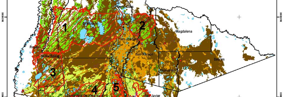

19 Proposed conservation sites


20 Impact of climate changes on flooding, biodiversity and anthropogenic activities in a large Amazonian floodplain system.
Understanding the hydrology of the large wetlands of the Bolivian Amazon using remote sensing and hydrological modeling
 Understanding the hydrology of the large wetlands of the Bolivian Amazon using remote sensing and hydrological modeling Preliminary results 6 th SO HYBAM Scientific Meeting Cusco, Octubre 2015 Alex Ovando
A NEW GIS-BASED RIVER BASIN FRAMEWORK
 A NEW GIS-BASED RIVER BASIN FRAMEWORK FOR AQUATIC ECOSYSTEM CONSERVATION IN THE AMAZON www.amazonwaters.org info@amazonwaters.org 2 3 Introduction The Amazon Waters Initiative is a call to action to conceptualize
Tropical Rainforests in the Pleistocene
 Tropical Rainforests in the Pleistocene tropics stable during Pleistocene? 1 C temperature drop based on 1976 CLIMAP study of warm vs. cold loving forams (vs. 10 C in North Atlantic) Paleothermometers
Tropical Rainforests in the Pleistocene
 Tropical Rainforests in the Pleistocene tropics stable during Pleistocene? 1 C temperature drop based on 1976 CLIMAP study of warm vs. cold loving forams (vs. 10 C in North Atlantic) Pollen analysis of
Comparison of inundation patterns among major South American floodplains
 JOURNAL OF GEOPHYSICAL RESEARCH, VOL. 107, NO. D20, 8038, 10.1029/2000JD000306, 2002 Comparison of inundation patterns among major South American floodplains Stephen K. Hamilton, 1 Suzanne J. Sippel, 1,2
ecotones during the late Holocene in lowland South America
 Reply to Silva: Dynamic humanvegetation climate interactions at forest ecotones during the late Holocene in lowland South America Article Accepted Version Carson, J., Whitney, B., Mayle, F., Iriarte, J.,
Ecosystems Chapter 4. What is an Ecosystem? Section 4-1
 Ecosystems Chapter 4 What is an Ecosystem? Section 4-1 Ecosystems Key Idea: An ecosystem includes a community of organisms and their physical environment. A community is a group of various species that
Biosphere Biome Ecosystem Community Population Organism
 Ecology ecology - The study of living things and how they relate to their environment Levels of Organization in Ecology organism lowest level one living thing population collection of organisms of the
* : corresponding author :
 Maurice-Bourgoin L., Fraizy P., Alanoca L., Seyler P., and Guyot J.L., 200. Hydrological control on the temporal variability of mercury in surface waters of the Upper Madeira basin, Bolivia. In: 2fh Int.
GLOBWETLAND AFRICA TOOLBOX
 The GlobWetland Africa Toolbox is an open source and free-of-charge software toolbox for inventorying, mapping, monitoring and assessing wetlands. The toolbox comes with end-to-end processing workflows
Kyoto and Carbon Initiative - the Ramsar / Wetlands International perspective
 Kyoto and Carbon Initiative - the Ramsar / Wetlands International perspective (the thoughts of Max Finlayson, as interpreted by John Lowry) Broad Requirements Guideline(s) for delineating wetlands (specifically,
CHAPTER 6 & 7 VOCABULARY
 CHAPTER 6 & 7 VOCABULARY 1. Biome 2. Climate 3. Latitude 4. Altitude 5. Emergent layer 6. Epiphyte 7. Understory 8. Permafrost 9. Wetland 10.Plankton 11.Nekton 12.Benthos 13.Littoral zone 14.Benthic zone
Geography Class XI Fundamentals of Physical Geography Section A Total Periods : 140 Total Marks : 70. Periods Topic Subject Matter Geographical Skills
 Geography Class XI Fundamentals of Physical Geography Section A Total Periods : 140 Total Marks : 70 Sr. No. 01 Periods Topic Subject Matter Geographical Skills Nature and Scope Definition, nature, i)
APPENDIX PHASE 1 GREEN INFRASTRUCTURE FRAMEWORK
 APPENDIX PHASE 1 GREEN INFRASTRUCTURE FRAMEWORK KANSAS MISSOURI CONTENTS A DATA WISHLIST 4 B PRECEDENTS 7 C WORKSHOP MATERIALS 13 D ANALYSIS PROCESS 124 E ATLAS & PLAYBOOK DETAILS 156 F POLICY ANALYSIS
Coupling a basin erosion and river sediment transport model into a large scale hydrological model
 Hydrology and Geodynamics of the basins of South America 4 th scientific meeting of ORE HYBAM www.ore-hybam.org Lima, 6-9 September 2011 Coupling a basin erosion and river sediment transport model into
BIODIVERSITY PROSPECTING
 BIODIVERSITY PROSPECTING LECTURE OUTLINE The topic Biodiversity Prospecting will be divided in three lectures with the following approaches: Biodiversity Prospecting Definitions and Concepts Biodiversity
Technical Note: Hydrology of the Lake Chilwa wetland, Malawi
 Technical Note: Hydrology of the Lake Chilwa wetland, Malawi Matthew McCartney June 27 Description Lake Chilwa is located in the Southern region of Malawi on the country s eastern boarder with Mozambique
Assessing state-wide biodiversity in the Florida Gap analysis project
 University of Nebraska - Lincoln DigitalCommons@University of Nebraska - Lincoln Nebraska Cooperative Fish & Wildlife Research Unit -- Staff Publications Nebraska Cooperative Fish & Wildlife Research Unit
Chapter 7 Part III: Biomes
 Chapter 7 Part III: Biomes Biomes Biome: the major types of terrestrial ecosystems determined primarily by climate 2 main factors: Temperature and precipitation Depends on latitude or altitude; proximity
Introduction. Ecology is the scientific study of the interactions between organisms and their environment.
 Introduction Ecology is the scientific study of the interactions between organisms and their environment. 1. The interactions between organisms and their environments determine the distribution and abundance
What is the future of Amazon
 What is the future of Amazon forests under climate change? -Increase in temperatures of ~3C -20% reduction in precipitation over 21 st cent. Two kinds of philosophy in predicting Amazon future Similar
Biodiversität und Fernerkundung im Skalierungskontext des BrahmaTWinn-Projektes
 Biodiversität und Fernerkundung im Skalierungskontext des BrahmaTWinn-Projektes Norbert Exler - Iris Wagner - Georg Janauer 6th EU Framework Programme Priority: Global Change and Ecosystems Contract: No.
NASA Flood Monitoring and Mapping Tools
 National Aeronautics and Space Administration ARSET Applied Remote Sensing Training http://arset.gsfc.nasa.gov @NASAARSET NASA Flood Monitoring and Mapping Tools www.nasa.gov Outline Overview of Flood
GIS Solutions in Natural Resource Management: Balancing the Technical- Political Equation
 GIS Solutions in Natural Resource Management: Balancing the Technical- Political Equation Stan Morain, Editor SUB Gdttlngen 7 208 520 309 98 A14447 0NW0RD PRESS V? % \
Biodiversity-Hotspots
 GE 2211 Environmental Science and Engineering Unit II Biodiversity-Hotspots M. Subramanian Assistant Professor Department of Chemical Engineering Sri Sivasubramaniya Nadar College of Engineering Kalavakkam
The effects of errors in measuring drainage basin area on regionalized estimates of mean annual flood: a simulation study
 Predictions in Ungauged Basins: PUB Kick-off (Proceedings of the PUB Kick-off meeting held in Brasilia, 20 22 November 2002). IAHS Publ. 309, 2007. 243 The effects of errors in measuring drainage basin
Assessing Michigan s Biological diversity. Michigan Natural Features Inventory MSU Extension
 Assessing Michigan s Biological diversity John Paskus,, Amy Derosier,, Edward Schools, and Helen Enander Michigan Natural Features Inventory MSU Extension Goal Provide scientifically based information
Biodiversity: Facts and figures (tables from the report)
") Vascular plant * Country Number Australia 15,638 Brazil 56,215 China 8,200 Colombia 32,200 Congo, Democratic Republic 11,007 Costa Rica 12,119 Ecuador 19,362 India 18,664 Indonesia 29,375 Madagascar 9,505
Vascular plant * Country Number Australia 15,638 Brazil 56,215 China 8,200 Colombia 32,200 Congo, Democratic Republic 11,007 Costa Rica 12,119 Ecuador 19,362 India 18,664 Indonesia 29,375 Madagascar 9,505
Canada s Policy for the Conservation of Wild Pacific Salmon: conservation planning for an uncertain future.
 Canada s Policy for the Conservation of Wild Pacific Salmon: conservation planning for an uncertain future. Brian Riddell and Blair Holtby, Dept. Fisheries & Oceans, Science Branch, Pacific Biological
Ecosystem Indicators. Age Poom. Environmental Management Master Course CAU Ecology Centre SS 2006
 Ecosystem Indicators Age Poom Environmental Management Master Course CAU Ecology Centre SS 2006 Indicator definitions Purpose of development and use of indicators Characteristics and requirements of indicators
Resolution XIII.23. Wetlands in the Arctic and sub-arctic
 13th Meeting of the Conference of the Contracting Parties to the Ramsar Convention on Wetlands Wetlands for a Sustainable Urban Future Dubai, United Arab Emirates, 21-29 October 2018 Resolution XIII.23
Earth s Major Terrerstrial Biomes. *Wetlands (found all over Earth)
") Biomes Biome: the major types of terrestrial ecosystems determined primarily by climate 2 main factors: Depends on ; proximity to ocean; and air and ocean circulation patterns Similar traits of plants
Biomes Biome: the major types of terrestrial ecosystems determined primarily by climate 2 main factors: Depends on ; proximity to ocean; and air and ocean circulation patterns Similar traits of plants
Seasonal and interannual relations between precipitation, soil moisture and vegetation in the North American monsoon region
 Seasonal and interannual relations between precipitation, soil moisture and vegetation in the North American monsoon region Luis A. Mendez-Barroso 1, Enrique R. Vivoni 1, Christopher J. Watts 2 and Julio
A global and long-term inundation extent dataset from multiple-satellite observations: towards high spatial resolution
 A global and long-term inundation extent dataset from multiple-satellite observations: towards high spatial resolution Filipe Aires, Estellus, France Catherine Prigent, LERMA, Observatoire de Paris, France
BASIS FOR RIVER RESTORATION PROJECT
 The FLUVIO FCT-Doctoral Program Hydromorphological and Habitat Restoration Course Diego García de Jalón and Marta González del Tánago, UPM Madrid BASIS FOR RIVER RESTORATION PROJECT Throughout the course,
Name Hour. Section 4-1 The Role of Climate (pages 87-89) What Is Climate? (page 87) 1. How is weather different from climate?
 What Is Climate? (page 87) 1. How is weather different from climate?") Name Hour Section 4-1 The Role of Climate (pages 87-89) What Is Climate? (page 87) 1. How is weather different from climate? 2. What factors cause climate? The Greenhouse Effect (page 87) 3. Circle the
Name Hour Section 4-1 The Role of Climate (pages 87-89) What Is Climate? (page 87) 1. How is weather different from climate? 2. What factors cause climate? The Greenhouse Effect (page 87) 3. Circle the
The following statements will be changed into TRUE/FALSE Questions. STUDY! (Hi-light important info)
") BIOME STUDY GUIDE!!!! ~There will be a map on your Biome Exam! ~ You will also need to know and understand the zones of the marine and freshwater biomes. ~FYI- I will collect your Biome Suitcases on WEDNESDAY
BIOME STUDY GUIDE!!!! ~There will be a map on your Biome Exam! ~ You will also need to know and understand the zones of the marine and freshwater biomes. ~FYI- I will collect your Biome Suitcases on WEDNESDAY
By: Meghan Grill, Jessica Schad, Libby Stofko
 By: Meghan Grill, Jessica Schad, Libby Stofko Forging through the dense jungles, you must learn to live off nothing more than the invaluable tools found in the nature. In the rainforest the contestants
Chapter 52: An Introduction to Ecology and the Biosphere
 AP Biology Guided Reading Name Chapter 52: An Introduction to Ecology and the Biosphere Overview 1. What is ecology? 2. Study Figure 52.2. It shows the different levels of the biological hierarchy studied
Hydrologic Analysis for Ecosystem Restoration
 Hydrologic Analysis for Ecosystem Restoration Davis, California Objectives: To provide participants with: 1) an understanding of the issues in restoration studies; 2) an overview of Corps policies and
Chapter 52 An Introduction to Ecology and the Biosphere
 Chapter 52 An Introduction to Ecology and the Biosphere Ecology The study of the interactions between organisms and their environment. Ecology Integrates all areas of biological research and informs environmental
Land cover research, applications and development needs in Slovakia
 Land cover research, applications and development needs in Slovakia Andrej Halabuk Institute of Landscape Ecology Slovak Academy of Sciences (ILE SAS) Štefánikova 3, 814 99 Bratislava, Slovakia Institute
HISTORICAL DELTA LANDSCAPES Conceptual models for building a diverse and resilient future
 HISTORICAL DELTA LANDSCAPES ITEM REMOVED DUE TO COPYRIGHT STATUS Conceptual models for building a diverse and resilient future Robin Grossinger and Alison Whipple San Francisco Estuary Institute/Aquatic
A Small Migrating Herd. Mapping Wildlife Distribution 1. Mapping Wildlife Distribution 2. Conservation & Reserve Management
 A Basic Introduction to Wildlife Mapping & Modeling ~~~~~~~~~~ Rev. Ronald J. Wasowski, C.S.C. Associate Professor of Environmental Science University of Portland Portland, Oregon 8 December 2015 Introduction
Measuring ecosystems and biodiversity and related goods and services
 Measuring ecosystems and biodiversity and related goods and services World Bank, WAVES Partnership Meeting Michael Bordt, EASD Statistics Canada March 30, 2011 Outline What exists already in Canada and
How the TRMM 3b42 v7 product reproduces the seasonal cycles of precipitation in the different regions of the Amazon Basin?
 How the TRMM 3b42 v7 product reproduces the seasonal cycles of precipitation in the different regions of the Amazon Basin? J.Ronchail LOCEAN UMR7617 CNRS PARIS 7 FRANCE Véronique MICHOT V.Dubreuil, B.Funatsu,
United States Department of the Interior NATIONAL PARK SERVICE Northeast Region
 United States Department of the Interior NATIONAL PARK SERVICE Northeast Region June 17, 2017 REQUEST FOR STATEMENTS OF INTEREST and QUALIFICATIONS Project Title: ASSESSMENT OF NATURAL RESOURCE CONDITION
EU BON Building the European Biodiversity Observation Network
 EU BON Building the European Biodiversity Observation Network Christoph L. Häuser christoph.haeuser@mfn-berlin.de Museum für Naturkunde - Leibniz Institute for Research on Evolution and Biodiversity Berlin,
The role of flood plains in the hydrology and sediment dynamics of the Amazon River, Brazil.
 Sediment Budgets I (Proceedings of symposium S1 held during the Seventh IAHS Scientific Assembly at Foz do Iguaçu, Brazil, April 2005). IAHS Publ. 291, 2005. 310 The role of flood plains in the hydrology
Capabilities and Limitations of Land Cover and Satellite Data for Biomass Estimation in African Ecosystems Valerio Avitabile
 Capabilities and Limitations of Land Cover and Satellite Data for Biomass Estimation in African Ecosystems Valerio Avitabile Kaniyo Pabidi - Budongo Forest Reserve November 13th, 2008 Outline of the presentation
DEVELOP National Program
 DEVELOP National Program GLSLCI 2015 Annual Meeting and Conference Sarnia, Ontario 19 June 2015 DEVELOP National Program NASA GLSLCI 2015 June 2015 NASA Earth observations NASA Earth observations include
Using Information and Geospatial Technologies to Support Biodiversity Conservation Policy Options in Latin America
 Using Information and Geospatial Technologies to Support Biodiversity Conservation Policy Options in Latin America Cover map credit: Javier Alfonso Racero-Casarrubia Using Information and Geospatial Technologies
Courtesy of Tomi Petr
 Lake Dal, rich in submerged aquatic plants, is threatened by pollution, Kashmir, India Lakes, reservoirs, rivers and streams are important habitats for inland fisheries, but they are threatened by human
Euscorpius. Occasional Publications in Scorpiology
 Euscorpius Occasional Publications in Scorpiology A New Locality of Mesobuthus eupeus thersites (C. L. Koch, 1839) (Scorpiones: Buthidae) in East Kazakhstan Alexander A. Fomichev December 2011 No. 136
Bright blue marble floating in space. Biomes & Ecology
 Bright blue marble floating in space Biomes & Ecology Chapter 50 Spheres of life Molecules Cells (Tissues Organ Organ systems) Organisms Populations Community all the organisms of all the species that
CLIMATE RESILIENT ALTITUDINAL GRADIENTS (CRAGs)
") CLIMATE RESILIENT ALTITUDINAL GRADIENTS (CRAGs) BUILDING CLIMATE CHANGE RESILIENCE IN THE KIVU- RUSIZI WATERSHEDS Great Lake Conference Entebbe 2017 Chris Magero WHAT ARE CRAGs? Climate-Resilient Altitudinal
CLIMATE RESILIENT ALTITUDINAL GRADIENTS (CRAGs) BUILDING CLIMATE CHANGE RESILIENCE IN THE KIVU- RUSIZI WATERSHEDS Great Lake Conference Entebbe 2017 Chris Magero WHAT ARE CRAGs? Climate-Resilient Altitudinal
Pee Dee Explorer. Science Standards
 Science Standards About Pee Dee Explorer What does it mean when someone says they are from the "Pee Dee" of South Carolina? A place is bigger than its physical geography. A "sense of place" weaves together
Krešimir Žganec, doc. dr. sc. University of Zadar
 Krešimir Žganec, doc. dr. sc. University of Zadar Project aim: highlight the most outstanding freshwater/river ecosystems in Serbia Expected results: A map showing the most outstanding freshwater ecosystems
THE TRANSECTS. Oldenburger,F.H.F. & Norde,R.* Online publication 2009 Correspondence author.
 THE TRANSECTS By Oldenburger,F.H.F. & Norde,R.* Online publication 2009 Correspondence author. Email r.norde@kpnplanet.nl Apart from the floristic inventarisation, the syn-ecological and syn-systematic
International Symposium CLIMATE-ES March 2015 Tortosa, Tarragona, Spain
 1 2 3 4 1 (1) Museo Nacional de Ciencias Naturales, CSIC, 28006 Madrid (2) Dpt. of Geography and Earth Sciences, Aberystwyth University, UK (3) Institute of Geography, Leipzig University, 04103 Leipzig,
Catalonia is a small region, managed by an autonomous government (depending from Spain), and placed in NE. Spain, next to Mediterranean sea.
, and placed in NE. Spain, next to Mediterranean sea.") Characterization of the river basin according to the WFD The Catalan Basins, a case of small Mediterranean water district Planning Department c/ Provença, 204-208 08036-Barcelona Introduction to Catalonia
Characterization of the river basin according to the WFD The Catalan Basins, a case of small Mediterranean water district Planning Department c/ Provença, 204-208 08036-Barcelona Introduction to Catalonia
Mesoscale and High Impact Weather in the South American Monsoon Leila M. V. Carvalho 1 and Maria A. F. Silva Dias 2 1
 Mesoscale and High Impact Weather in the South American Monsoon Leila M. V. Carvalho 1 and Maria A. F. Silva Dias 2 1 University of California, Santa Barbara 2 University of Sao Paulo, Brazil Objectives
Director: Soroosh Sorooshian
 Director: Soroosh Sorooshian X. Gao B. Imam K. Hsu S. O Rourke D. Hohnbaum J. Li G.H. Park D. Braithwaite E. Pritchard B. Khakbaz W. Chu A. Behrangi Alex R. Sutlana Joey A. Zahraei Developing state-of-the-art
Spheres of Life. Ecology. Chapter 52. Impact of Ecology as a Science. Ecology. Biotic Factors Competitors Predators / Parasites Food sources
 "Look again at that dot... That's here. That's home. That's us. On it everyone you love, everyone you know, everyone you ever heard of, every human being who ever was, lived out their lives. Ecology Chapter
Watershed concepts for community environmental planning
 Purpose and Objectives Watershed concepts for community environmental planning Dale Bruns, Wilkes University USDA Rural GIS Consortium May 2007 Provide background on basic concepts in watershed, stream,
ECOLOGICALLY SENSITIVE AREAS IN WESTERN GHATS
 ECOLOGICALLY SENSITIVE AREAS IN WESTERN GHATS Introduction The Western Ghats was declared as an ecological hotspot in 1988. A large number of plants, amphibians, birds, reptiles, mammals are endemic to
Land Accounts - The Canadian Experience
 Land Accounts - The Canadian Experience Development of a Geospatial database to measure the effect of human activity on the environment Who is doing Land Accounts Statistics Canada (national) Component
The River Restoration Centre therrc.co.uk. Understanding Fluvial Processes: supporting River Restoration. Dr Jenny Mant
 The River Restoration Centre therrc.co.uk Understanding Fluvial Processes: supporting River Restoration Dr Jenny Mant Jenny@therrc.co.uk Understanding your catchment Hydrology Energy associated with the
HYDROLOGIC RESPONSE OF HILLSLOPE SEEPS AND HEADWATER STREAMS OF THE FORT WORTH PRAIRIE
 HYDROLOGIC RESPONSE OF HILLSLOPE SEEPS AND HEADWATER STREAMS OF THE FORT WORTH PRAIRIE Shannon Jones M. S. Environmental Science TCU School of Geology, Energy and the Environment November 2, 2013 HEADWATERS
What two factors have the most important effect on a region's climate?
 Chapter 4 - Kinds of Ecosystems 4.1 Forests biome - climate - weather conditions - What two factors have the most important effect on a region's climate? Types of Forests Tropical Rain Forests location
Overview. How many species are there? Major patterns of diversity Causes of these patterns Conserving biodiversity
 Overview How many species are there? Major patterns of diversity Causes of these patterns Conserving biodiversity Biodiversity The variability among living organisms from all sources, including, inter
HYDRO-ECOREGIONS OF THE BOLIVIAN AMAZON: A GEOGRAPHICAL FRAMEWORK FOR THE FUNCTIONING OF RIVER ECOSYSTEMS
 The Ecohydrology of South American Rivers and Wetlands. IAHS Special Publication no. 6, 2002. 69 CHAPTER 5 HYDRO-ECOREGIONS OF THE BOLIVIAN AMAZON: A GEOGRAPHICAL FRAMEWORK FOR THE FUNCTIONING OF RIVER
This table connects the content provided by Education Perfect to the NSW Syllabus.
 Education Perfect Geography provides teachers with a wide range of quality, engaging and innovative content to drive positive student learning outcomes. Designed by teachers and written by our in-house
CHAPTER 1 INTRODUCTION
 CONTENTS Page No. CHAPTER 1 INTRODUCTION 1.1 LOCATION OF THE PROJECT 1-1 1.2 BACKGROUND 1-1 1.2.1 Previous Studies 1-2 1.2.2 NHPC Proposal 1-2 1.2.3 Work after Submission of PFR 1-3 1.3 PROJECT AREA 1-3
Global reviews of wetland inventory, classification and delineation
 Max Finlayson Institute for Land, Water & Society Charles Sturt University Albury, Australia Global reviews of wetland inventory, classification and delineation Initiatives/meetings over two decades have
Hydrological modelling in Amazonia use of the MGB-IPH model and alternative databases
 246 Predictions in Ungauged Basins: Promise and Progress (Proceedings of symposium S7 held during the Seventh IAHS Scientific Assembly at Foz do Iguaçu, Brazil, April 2005). IAHS Publ. 303, 2006. Hydrological
Cambridge International Examinations Cambridge International General Certificate of Secondary Education
 Cambridge International Examinations Cambridge International General Certificate of Secondary Education *1869999605* GEOGRAPHY 0460/11 Paper 1 October/November 2017 Candidates answer on the Question Paper.
Texas Alliance of Groundwater Districts Annual Summit
 Texas Alliance of Groundwater Districts Annual Summit Using Remote-Sensed Data to Improve Recharge Estimates August 28, 2018 by Ronald T. Green1, Ph.D., P.G. and Stu Stothoff2, Ph.D., P.G. Earth Science
Module 3. Basic Ecological Principles
 Module 3. Basic Ecological Principles Ecosystem Components Abiotic Biotic Species & Habitat The Biomes of North America Communities Energy & Matter Cycles in Ecosystems Primary Productivity Simple Ecosystem
Birch Creek Geomorphic Assessment and Action Plan
 Birch Creek Geomorphic Assessment and Action Plan Jim Webster Tim Hanrahan, PhD, CFM Jesse Schwartz, PhD Zach Hill January 22, 2015 White Eagle Grange This Project is a First Step in Strategy Planning
Background. Points of Discussion. Hydrographic Models
 Airborne Laser Remote Sensing Technology: Providing Essential Hydrologic Information in the 21 st Century Warwick Hadley, Optech Incorporated Presented by: Warwick Hadley Sales Manager, Middle East and
How Do Human Impacts and Geomorphological Responses Vary with Spatial Scale in the Streams and Rivers of the Illinois Basin?
 How Do Human Impacts and Geomorphological Responses Vary with Spatial Scale in the Streams and Rivers of the Illinois Basin? Bruce Rhoads Department of Geography University of Illinois at Urbana-Champaign
Terrestrial Flora and Fauna
 Terrestrial Flora & Fauna Part I In short, the animal and vegetable lines, diverging widely above, join below in a loop. 1 Asa Gray Terrestrial Flora and Fauna Ecosystems and Biomes Terrestrial Flora Terrestrial
Using MODIS imagery to validate the spatial representation of snow cover extent obtained from SWAT in a data-scarce Chilean Andean watershed
 Using MODIS imagery to validate the spatial representation of snow cover extent obtained from SWAT in a data-scarce Chilean Andean watershed Alejandra Stehr 1, Oscar Link 2, Mauricio Aguayo 1 1 Centro
Human Activity in the Amazon
 Name Date Human Activity in the Amazon The Amazon rain forest is rich in resources that are in high demand around the world. These resources often lie deep in the forest. This makes it difficult to transport
Positional accuracy of the drainage networks extracted from ASTER and SRTM for the Gorongosa National Park region - Comparative analysis
 Positional accuracy of the drainage networks extracted from ASTER and SRTM for the Gorongosa National Park region - Comparative analysis Tiago CARMO 1, Cidália C. FONTE 1,2 1 Departamento de Matemática,
Monitoring of Tropical Deforestation and Land Cover Changes in Protected Areas: JRC Perspective
 Monitoring of Tropical Deforestation and Land Cover Changes in Protected Areas: JRC Perspective Z. Szantoi, A. Brink, P. Mayaux, F. Achard Monitoring Of Natural resources for DEvelopment (MONDE) Joint
Spatial representation of evapotranspiration in the Mara basin: results derived from the SWAT model and remote sensing products
 Spatial representation of evapotranspiration in the Mara basin: results derived from the SWAT model and remote sensing products Alemayehu, T 1., van Griensven, A. 1,2, Kilonzo, F. 1,2, and Bauwens, W.
Data Quality and Uncertainty
 Data Quality and Uncertainty The power of GIS analysis is based on the assembly of layers of data, but as data layers increase, errors multiply - quality decreases. Garbage in, garbage out. High quality
CadasterENV Sweden Time series in support of a multi-purpose land cover mapping system at national scale
 CadasterENV Sweden Time series in support of a multi-purpose land cover mapping system at national scale Mats Rosengren, Camilla Jönsson ; Metria AB Marc Paganini ; ESA ESRIN Background CadasterENV Sweden
Space for Sustainable Development. Disasters
 Rio+20 - United Nations Conference on Sustainable Development, June 2012 Rio de Janeiro, Brazil Space for Sustainable Development Disasters Carlos AfonsoNobre Carlos FredericoAngelis Why natural disasters
FLOOD ANALYSIS USING SATELLITE DATA AND GEOMORPHOLOGICAL SURVEY MAP SHOWING CLASSIFICATION OF FLOOD-INUNDATED AREAS
 FLOOD ANALYSIS USING SATELLITE DATA AND GEOMORPHOLOGICAL SURVEY MAP SHOWING CLASSIFICATION OF FLOOD-INUNDATED AREAS Yasuharu YAMADA* *Japan International Research Center for Agricultural Sciences (JIRCAS),
How does the greenhouse effect maintain the biosphere s temperature range? What are Earth s three main climate zones?
 Section 4 1 The Role of Climate (pages 87 89) Key Concepts How does the greenhouse effect maintain the biosphere s temperature range? What are Earth s three main climate zones? What Is Climate? (page 87)
Wonders of the Rainforest Resource Book
 E-BOOK CODE: REAU5021 Special School Photocopy Master Edition Wonders of the Rainforest Resource Book IMSI by Jane Bourke Wonders of the Rainforest Contents Contents... 3 Learning About Rainforests...
Rising Sea Levels: Time for Proactive Action in Florida and the Caribbean?
 Rising Sea Levels: Time for Proactive Action in Florida and the Caribbean? Dr. Alan Fyall and Dr. Thomas Wahl National Center for Integrated Coastal Research, University of Central Florida Dr. Roberta
Taxonomy and Systematics: a broader classification system that also shows evolutionary relationships
 Taxonomy: a system for naming living creatures Carrolus Linnaeus (1707-1778) The binomial system: Genus and species e.g., Macrocystis pyrifera (Giant kelp); Medialuna californiensis (halfmoon) Taxonomy
Phenology, Networks and Climatic Change
 unesp Phenology, Networks and Climatic Change Patrícia Morellato Laboratório de Fenologia Phenology Laboratory Departamento de Botânica UNESP Univ Estadual Paulista, Rio Claro, São Paulo Brazil PHENOLOGY
Pattern to Process: Research and Applications for Understanding Multiple Interactions and Feedbacks on Land Cover Change (NAG ).
.") Pattern to Process: Research and Applications for Understanding Multiple Interactions and Feedbacks on Land Cover Change (NAG 5 9232). Robert Walker, Principle Investigator Department of Geography 315
Pattern to Process: Research and Applications for Understanding Multiple Interactions and Feedbacks on Land Cover Change (NAG 5 9232). Robert Walker, Principle Investigator Department of Geography 315
Sediment yields and erosion rates in the Napo River basin: an Ecuadorian Andean Amazon tributary
 220 Sediment Transfer through the Fluvial System (Proceedings of a symposium held in Moscow, August 2004). IAHS Publ. 288, 2004 Sediment yields and erosion rates in the Napo River basin: an Ecuadorian
Development of Riparian Maps for Sonoma County Long Term Riparian Corridor Conservation. Mark Tukman & Dylan Loudon Tukman Geospatial
 L A N D F O R Development of Riparian Maps for Sonoma County Long Term Riparian Corridor Conservation Mark Tukman & Dylan Loudon Tukman Geospatial L I F E Mark Background on functional riparian mapping