Biogeographic remarks and spatial scales
|
|
|
- Justin Geoffrey Dalton
- 5 years ago
- Views:
Transcription
1 WORKSHOP ON THE DESIGN OF IMPACT REFERENCE ZONES AND PRESERVATION REFERENCE ZONES IN DSM CONTRACT AREAS Biogeographic remarks and spatial scales Andrey Gebruk P.P. Shirshov Institute of Oceanology, RAS, Moscow The Hilton Berlin, September 2017
, Co-rich Fe-Mn crusts (C)")


2 Locations of global exploration contracts for manganese nodules (N), Co-rich Fe-Mn crusts (C) and seafloor massive sulfides (S for contracts within the Area, orange for contracts within EEZs) Abyssal plains m Seamounts m Ocean ridges m [After Petersen et al. (2016)]
3 Main biogeographic concepts Species ( Biotic ) Approaches Based on distribution of: Communities ( Biocenosis ) Criteria of boundaries Environmental parameters ( Landscape ) Crowding of species range limits Analysis of species ranges (Areographic analysis) Differences between local biotas Methods Cluster analysis Sharp gradients of environmental parameters Analysis of gradients of environmental parameters Mironov (2013)

4 Proposed biogeography of the deep ocean floor (Watling et al., 2013) Proposed Abyssal Provinces

5 Zoogeographic zonation of abyssal and hadal zones Vinogradova (1959; 1997)
 Mironov (1987; 2013) Mironov et al.")
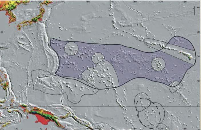
6 Biogeographic regionalization of the abyssal Pacific Ocean WP North-East Pacific region EP Indo-West Pacific region Antarctic region Provinces: NP North Pacific EP East Pacific WP West Pacific CP Central Pacific In red after Vinogradova (1959; 1997) Mironov (1987; 2013) Mironov et al. (2015)

7 A proposed biogeography of the deep ocean floor (Watling et al., 2013) Proposed Lower Bathyal Provinces

8 Large-scale faunistic regions in the bathyal of the world ocean 1 faunistic boundaries between sub-continental and oceanic regions; 2 oceanic exotic regions; 3 - zone of occurrence of exotic regions; 4 winter surface isotherms 10 o and 20 o C. From: Mironov (1994)

9 Biogeographic relationships among deep-sea hydrothermal vent faunas at global scale (Bachraty et al., 2009)
![Global Vent Biogeography [after Rogers et al. (2012) in PLoS] Results of geographically constrained clustering using multivariate regression trees.](/docs-images/82/84773382/images/10-0.jpg "An 11-province model based on the combined dataset was the most frequent optimal model when using multiple cross-validations.")
10 Global Vent Biogeography [after Rogers et al. (2012) in PLoS] Results of geographically constrained clustering using multivariate regression trees. An 11-province model based on the combined dataset was the most frequent optimal model when using multiple cross-validations. Vent provinces are resolved comprising the Mid-Atlantic Ridge, the ESR, the northern, central, and southern East Pacific Rise, a further province located south of the Easter Microplate, four provinces in the western Pacific, and a further Indian Ocean province. doi: /journal.pbio g006

11 Western Pacific vent biogeography Rowden et al. (in prep)
 in PLoS] Global network of hydrothermal vent fauna diversity, built on the basis of Jaccard s distance among fields and")

12 Global Vent Biogeography [after Moalic et al. (2012) in PLoS] Global network of hydrothermal vent fauna diversity, built on the basis of Jaccard s distance among fields and represented here at the effective percolation threshold (Dpe = See SOM). Circle size represents the betweenness centrality values of the corresponding field. Five provinces are highlighted by this network analysis: Mid-Atlantic Ridge (brown), Indian Ocean (red), Western-Pacific (yellow), Northeast-Pacific (green) and East-Pacific Rise (blue).
13 Main centres of re-distribution and distributional pathways of shelf/slope fauna in Cenozoic Tethys (Paleogen/Neogen boundary), 2- Indo-Malayan (Neogen), 3 - North Pacific, 4 - West Atlantic, 5 - Centres of re-distribution. Mironov (2006)

 Tittensor et al. (2010).")
14 Normalized richness Global ocean species richness distribution Major centres of shelf/slope fauna re-distribution in Cenozoic Mironov (2006) Tittensor et al. (2010). Nature 466:

15 Claim-Scale Spatial management Impact and Preservation Reference Zones ISBA/19/C/17, Reg.31 ISBA/16/A12/Rev.1 ISBAQ/18/A11, Reg. 33 Impact reference zones are areas to be used for assessing the effect of each contractor s activities in the Area on the marine environment and which are representative of the environmental characteristics of the Area. Preservation reference zones means areas in which no mining shall occur to ensure representative and stable biota of the seabed in order to assess any changes in the flora and fauna of the marine environment. (D. Jones, NOCS)
16 Locations of global exploration contracts for manganese nodules (N), Co-rich Fe-Mn crusts (C) and seafloor massive sulfides (S for licenses within the Area, orange for licenses within EEZs) Expl. Area 550x550 km; 150 km 2 (х5=cluster) km 2 Extent: 1 st km 100 km (per seamount) km km 2 Extent: 1000s km km km 2 Extent: 1 st 100s m 1 st km [ After Petersen et al. (2016)]

17 Courtesy Andy Dale SAMS, UK Settled sediment thickness Plume modeling 1 cm 50 km Area of seabed mined in one year = 12 km x 12 km box 1 mm ~ 0.1 mm ~ 1 mm > 1 cm 0.1 mm

18 Azores case study Plume modeling (Morato et al., unpublished)


19 Spatial limits for plume impact monitoring Some impact km??? Significant impact Plume Plume extent? km?

20 < 250 km > Manganese nodules < 300 km > km 2
 Patches of nodules on 0.")
. License Area 50 km PRZ: Size =?mined + impacted by plume PRZ: To include all types of habitats/ecosystems (incl.")
21 Manganese nodules Exploration Area - Apply for up to km 2-50% becomes License Area, other part is Reserved Area Reserved Area Relinquishment in 8 years Reduce size 3 yrs 20% 5 yrs 10% 8 yrs 20% < ~275 km > PRZ Mined Result: area of km 2 (not necessarily contiguous) Patches of nodules on km scale An area of about 8500 km 2 is estimated to be sufficient to support about 20 years of polymetallic nodule mining (Madureira et al., 2016; Jones et al., 2017). License Area 50 km PRZ: Size =?mined + impacted by plume PRZ: To include all types of habitats/ecosystems (incl. impacted by plume)


22 Cobalt crusts


23 Cobalt crusts Model mine site at seamount? PRZ >?10-50 km Large composite seamount Crust 2-3 cm thick, Area above 2.5 km ~ 2900 km 2 Area mined per year ~25 km 2 - in 20 yrs. ~500 km km can accommodate a single 20-years mining site Hein et al. (2009) Expl. Area 550x550 km; 150 km 2 (х5=cluster) km 2

.")
24 ? Depth range m 13 areas; 5 active + 3?active 1 per ~70 km in 9 1 field per area; in fields Σ 21 field; 7 active + 4?active One SMS deposit per 150 km (Cherkashev et al., 2010). Many more inactive sites than active sites (Hannington et al., 2011). [After Cherkashov et al.; Beltenev et al.]


.")
25 ? Puy des Folles Yubileinoe Zenit-Victoria Irinovskoe m Semenov m Maximum field size 1600 х 2700 m (= ~4.3 km 2 ) at Semenov 4. Modern activity at Semenov 2 Minimum field size: 50 x 150 m (Ashadze-1). [After Cherkashov et al.; Beltenev et al.]


26 < 10 km > Irinovskoe N W Semenov 13 30N < 10 km > 4.3 km km 2 = 25 x 10x10 km 2
 1 000")
27 km 2 < 275 km > PRZ Mn nodules Plume? km PRZ design/location PRZ??? SMS: 10x10 km km 2 PRZ Cobalt km 2 (х5=cluster) km 2
28 How many? How big? Preservation Reference Zone To include all types of habitats/ecosystems (incl. impacted by plume) found in mined area Mn nodules at least one comparable in size to mined block/unit + area impacted by plume Co Crusts at least one one block 4x5 km SMS at least one one block 10x10 km. Important! Comparable in size deposit/inactive field, depth, topography/location on the rift valley profile

")
29 Spatial limits for plume impact monitoring IRZ km?? 50 Plume 10 SMS: 10x10 km 2 Cobalt crusts: ~4x5 km (х5=cluster) Plume extent? km?
Impacts of Deep Sea Mining. Phil Weaver Seascape Consultants Romsey, UK
 Impacts of Deep Sea Mining Phil Weaver Seascape Consultants Romsey, UK phil.weaver@seascapeconsultants.co.uk MIN_GUIDE annual mee?ng, Brussels, 13-14 December, 2017 Three types of Deep Sea Mineral Mn-Nodules
Managing Impacts of Deep-seA resource exploitation - the MIDAS project. Phil Weaver Seascape Consultants Romsey, UK
 Managing Impacts of Deep-seA resource exploitation - the MIDAS project Phil Weaver Seascape Consultants Romsey, UK Seas at Risk workshop, Brussels 5 th November 2014 Total number of ISA Contractors Number
The Future of Deep-Sea Mining
 Linking Global & Regional levels in the Management of Marine Areas Beyond National Jurisdiction FAO, Rome, 18-20 February 2015 The Future of Deep-Sea Mining David Johnson Seascape Consultants Ltd EU FP7
Prospects and Status of Exploration for Polymetallic Sulphides. Georgy Cherkashov VNIIOkeangeologia St.Petersburg, RUSSIA
 Prospects and Status of Exploration for Polymetallic Sulphides Georgy Cherkashov VNIIOkeangeologia St.Petersburg, RUSSIA Introduction Outline Hydrothermal processes and seafloor massive sulfides (SMS):
Is sustainable Blue Growth possible? Prof. Alan Deidun FRSB Department of Geosciences, University of Malta Director, IOI Malta Training Centre
 Is sustainable Blue Growth possible? Prof. Alan Deidun FRSB Department of Geosciences, University of Malta Director, IOI Malta Training Centre Alan.de The Blue Growth context Potential of blue
Deep Sea Minerals in the Pacific Islands Region: Occurrence, Potential and Case Studies`
 Deep Sea Minerals in the Pacific Islands Region: Occurrence, Potential and Case Studies` 1st DSM Project Regional Workshop 6th 8th June 2011 Tanoa International Hotel Nadi, Fiji Akuila Tawake SPC/SOPAC
14.2 Ocean Floor Features Mapping the Ocean Floor
 14.2 Ocean Floor Features Mapping the Ocean Floor The ocean floor regions are the continental margins, the ocean basin floor, and the mid-ocean ridge. 14.2 Ocean Floor Features Continental Margins A continental
Non-living Resources of the OCS. Harald Brekke NPD
 Non-living Resources of the OCS Harald Brekke NPD The Continental Shelf and the Area http://www.grida.no/publications/shelf-last-zone/ Outer Continental Shelf Example http://www.grida.no/publications/shelf-last-zone/
Ocean Floor. Continental Margins. Divided into 3 major regions. Continental Margins. Ocean Basins. Mid-Ocean Ridges. Include:
 Ocean Floor Divided into 3 major regions Continental Margins Ocean Basins Mid-Ocean Ridges Continental Margins Include: Continental Shelves Continental Slopes Continental Rise 1 Continental Shelves Part
Small area of the ocean that is partially surrounded by land. The Ocean Basins. Three Major Oceans. Three Major Oceans. What is a SEA?
 The Ocean Basins How Deep is the Ocean? 1 2 Three Major Oceans Three Major Oceans Pacific Atlantic the shallowest ocean (3.3km average depth) Indian second shallowest ocean (3.8km average depth) Pacific
Earth / Environmental Science. Ch. 14 THE OCEAN FLOOR
 Earth / Environmental Science Ch. 14 THE OCEAN FLOOR The Blue Planet Nearly 70% of the Earth s surface is covered by the global ocean It was not until the 1800s that the ocean became an important focus
The Ocean Floor Chapter 14. Essentials of Geology, 8e. Stan Hatfield and Ken Pinzke Southwestern Illinois College
 The Ocean Floor Chapter 14 Essentials of Geology, 8e Stan Hatfield and Ken Pinzke Southwestern Illinois College The vast world ocean Earth is often referred to as the water planet 71% of Earth s surface
The Sea Floor. Chapter 2
 The Sea Floor Chapter 2 Geography of the Ocean Basins World ocean is the predominant feature on the Earth in total area Northern Hemisphere = 61% of the total area is ocean. Southern Hemisphere = about
Physiography Ocean Provinces p. 1 Dimensions p. 1 Physiographic Provinces p. 2 Continental Margin Province p. 2 Deep-Ocean Basin Province p.
 Physiography Ocean Provinces p. 1 Dimensions p. 1 Physiographic Provinces p. 2 Continental Margin Province p. 2 Deep-Ocean Basin Province p. 2 Mid-Ocean Ridge Province p. 3 Benthic and Pelagic Provinces
Map shows 3 main features of ocean floor
 Map shows 3 main features of ocean floor 2017 Pearson Education, Inc. Chapter 3 Marine Provinces 2017 Pearson Education, Inc. 1 Chapter 3 Overview The study of bathymetry determines ocean depths and ocean
Chapter 9 Lecture Outline. Oceans: The Last Frontier
 Chapter 9 Lecture Outline Oceans: The Last Frontier The Vast World Ocean Earth is referred to as the blue planet 71% of Earth s surface is oceans and marginal seas Continents and islands comprise the remaining
Lecture Outlines PowerPoint. Chapter 13 Earth Science 11e Tarbuck/Lutgens
 Lecture Outlines PowerPoint Chapter 13 Earth Science 11e Tarbuck/Lutgens 2006 Pearson Prentice Hall This work is protected by United States copyright laws and is provided solely for the use of instructors
Foundations of Earth Science, 6e Lutgens, Tarbuck, & Tasa
 Foundations of Earth Science, 6e Lutgens, Tarbuck, & Tasa Oceans: The Last Frontier Foundations, 6e - Chapter 9 Stan Hatfield Southwestern Illinois College The vast world ocean Earth is often referred
OCN 201 Mantle plumes and hot spots
 OCN 201 Mantle plumes and hot spots Question Long-term (>50 million years) changes in sea level are caused by: A. Changes in the volume of water in the ocean B. Changes in the volume of the ocean basins
Geography IIN. Exploration of Polymetallic Nodules
 Geography IIN Exploration of Polymetallic Nodules Cabinet approves extension of contract between India and The International Seabed Authority for the exploration of Polymetallic Nodules Background The
DeepSea Minerals Research in Indonesia : Status and Challenges
 KEMENTERIAN MINISTRY OF ENERGY ENERGI AND DAN MINERAL SUMBER RESOURCES DAYA MINERAL REPUBLIK REPUBLIC OF INDONESIA DeepSea Minerals Research in Indonesia : Status and Challenges Noor C.D Aryanto and Ediar
Chapter Overview. Bathymetry. Measuring Bathymetry. Measuring Bathymetry
 CHAPTER 3 Marine Provinces Chapter Overview The study of bathymetry determines ocean depths and ocean floor topography. Echo sounding and satellites are efficient bathymetric tools. Most ocean floor features
Earth s Continents and Seafloors. GEOL100 Physical Geology Ray Rector - Instructor
 Earth s Continents and Seafloors GEOL100 Physical Geology Ray Rector - Instructor OCEAN BASINS and CONTINENTAL PLATFORMS Key Concepts I. Earth s rocky surface covered by of two types of crust Dense, thin,
The Ocean Floor Earth Science, 13e Chapter 13
 The Ocean Floor Earth Science, 13e Chapter 13 Stanley C. Hatfield Southwestern Illinois College The vast world ocean Earth is often referred to as the blue planet Seventy-one percent of Earth s surface
Lecture Marine Provinces
 Lecture Marine Provinces Measuring bathymetry Ocean depths and topography of ocean floor Sounding Rope/wire with heavy weight Known as lead lining Echo sounding Reflection of sound signals 1925 German
Deep-sea Mining: The Basics. Overview. A fact sheet from June 2018
 A fact sheet from June 2018 Deep-sea Mining: The Basics NOAA Office of Ocean Exploration and Research Overview The deepest parts of the world s ocean feature ecosystems found nowhere else on Earth. They
Chapter 02 The Sea Floor
 Chapter 02 The Sea Floor Multiple Choice Questions 1. One of the following is not one of the world's major ocean basins: A. Atlantic Ocean B. Arctic Ocean C. Indian Ocean D. Antarctic Ocean E. Pacific
1. Name at least one place that the mid-atlantic Ridge is exposed above sea level.
 Interpreting Tectonic and Bathymetric Maps. The purpose of this lab is to provide experience interpreting the bathymetry of the seafloor in terms of tectonic and geologic settings and processes. Use the
Metalliferous Sediments of the World Ocean. Metalliferous Sediments of the World Ocean
 Gurvich Evgeny Gurvich evgeny gurvich was born in 1947 in Moscow. He received his Ph.D. and D.Sc. degrees from the P. P. Shirshov Institute of Oceanology in Moscow where he remained for more than 25 years.
24. Ocean Basins p
 24. Ocean Basins p. 350-372 Background The majority of the planet is covered by ocean- about %. So the majority of the Earth s crust is. This crust is hidden from view beneath the water so it is not as
Ocean Sciences 101 The Marine Environment OCEA 101 THE MARINE ENVIRONMENT MID-TERM EXAM
 OCEA 101 THE MARINE ENVIRONMENT MID-TERM EXAM Part I. Multiple Choice Questions. Choose the one best answer from the list, and write the letter legibly in the blank to the left of the question. 2 points
Geography of the world s oceans and major current systems. Lecture 2
 Geography of the world s oceans and major current systems Lecture 2 WHY is the GEOMORPHOLOGY OF THE OCEAN FLOOR important? (in the context of Oceanography) WHY is the GEOMORPHOLOGY OF THE OCEAN FLOOR important?
Bathymetry Measures the vertical distance from the ocean surface to mountains, valleys, plains, and other sea floor features
 1 2 3 4 5 6 7 8 9 10 11 CHAPTER 3 Marine Provinces Chapter Overview The study of bathymetry determines ocean depths and ocean floor topography. Echo sounding and satellites are efficient bathymetric tools.
Plate Tectonics: A Unifying Theory
 Plate Tectonics: A Unifying Theory What is Plate Tectonics? - 7 large tectonic plates and many smaller ones that break up the lithosphere - Plates are brittle and float on asthenosphere and glide past
Are seafloor hydrothermal sulphides deposits valuable mineral resources? Bramley J Murton
 Are seafloor hydrothermal sulphides deposits valuable mineral resources? Bramley J Murton Outline Why do we need new sources of metals? What are seafloor mineral deposits Where do they occur and why: Why
Marine Science and Oceanography
 Marine Science and Oceanography Marine geology- study of the ocean floor Physical oceanography- study of waves, currents, and tides Marine biology study of nature and distribution of marine organisms Chemical
Oceanography is the scientific study of oceans Oceans make up over 70% of the Earth s surface
 Oceanography Oceanography is the scientific study of oceans Oceans make up over 70% of the Earth s surface An ocean must be large and have features which set it apart from other oceans (currents, water
Deep-Sea and Sub-Seafloor Resources: A Polymetallic Sulphide and Co-Mn Crust Perspective. Stephen Roberts
 Deep-Sea and Sub-Seafloor Resources: A Polymetallic Sulphide and Co-Mn Crust Perspective by Stephen Roberts The LRET Research Collegium Southampton, 16 July 7 September 2012 1 Deep-Sea and Sub-Seafloor
Shape of the seafloor. Shape of the seafloor. Shape of the seafloor. Shape of the seafloor. Shape of the seafloor. Shape of the seafloor
 Multibeam echo sounders - Research vessel Scripps Institution of Oceanography R/V Roger Revelle depth Source: Scripps Institution of Oceanography http://woodshole.er.usgs.gov/project-pages/caribbean/movie1.html
Workshop background and objectives
 Cobalt crusts and the diversity and distribution patterns of seamount faunas Workshop background and objectives Tony Koslow March 2006 CSIRO Marine and Atmospheric Research Perth, Australia www.csiro.au
Chapter Two. Figure 02_02. Geography of the Ocean Basins. The Sea Floor
 Chapter Two The Sea Floor Geography of the Ocean Basins Figure 02_02 The world ocean is the predominant feature on the Earth in total area. In the Northern Hemisphere, 61% of the total area is ocean. In
UNCLOS Article 76- Formulae and constraint lines
 UNCLOS Article 76- Formulae and constraint lines Dr Lindsay Parson (UNCLOS Group, National Oceanography Centre, UK) ABLOS TUTORIAL SESSION - Article 76 of UNCLOS 10th October 2005 IHO/IAG/IOC Advisory
ARE YOU READY TO THINK? Look at the first slide THINK PAIR SHARE!
 ARE YOU READY TO THINK? Look at the first slide THINK PAIR SHARE! WHAT PROMINENT FEATURE CAN YOU IDENTIFY IN THIS PICTURE? What do you think the different colors represent? Who might find such a picture
Crustal Activity. Plate Tectonics - Plates - Lithosphere - Asthenosphere - Earth s surface consists of a major plates and some minor ones
 Name: Date: Period: Tectonics The Physical Setting: Earth Science CLASS NOTES Tectonics - s - Lithosphere - Asthenosphere - Earth s surface consists of a major plates and some minor ones The plates are
Seafloor Spreading and Paleomagnetism Activity
 Name: PART A: Ocean Bottom Profile Background: Seafloor spreading is the hypothesis that the sea floor moves sideways away from the crest of the mid- ocean ridge. It is estimated that 20 volcanic eruptions
Announcements. Manganese nodule distribution
 Announcements Lithospheric plates not as brittle as previously thought ESCI 322 Meet in Env. Studies Bldg Rm 60 at 1 PM on Tuesday One week (Thursday): Quiz on Booth 1994 and discussion. (Lots of odd terms
is a unifying theme in modern geology that integrates the earlier ideas of
 The concept of Global Plate Tectonics is a unifying theme in modern geology that integrates the earlier ideas of continental drift, sea-floor spread, and mountain building To explain why the present ocean
Oceanography, An Invitation to Marine Science 9e Tom Garrison. Ocean Basins Cengage Learning. All Rights Reserved.
 Oceanography, An Invitation to Marine Science 9e Tom Garrison 4 Ocean Basins Key Concepts Tectonic forces shape the seabed The ocean floor is divided into continental margins and deep ocean basins The
USU 1360 TECTONICS / PROCESSES
 USU 1360 TECTONICS / PROCESSES Observe the world map and each enlargement Pacific Northwest Tibet South America Japan 03.00.a1 South Atlantic Arabian Peninsula Observe features near the Pacific Northwest
SPC-EU EDF10 Deep Sea Minerals (DSM) Project WORKSHOP PROGRAMME
 Project WORKSHOP PROGRAMME") SPC-EU EDF10 Deep Sea Minerals (DSM) Project Pacific ACP States Regional Training Workshop on Geological, Technological, Biological and Environmental Aspects of Deep Sea Minerals WORKSHOP PROGRAMME Time
SPC-EU EDF10 Deep Sea Minerals (DSM) Project Pacific ACP States Regional Training Workshop on Geological, Technological, Biological and Environmental Aspects of Deep Sea Minerals WORKSHOP PROGRAMME Time
The Puzzling Plates Part I. Follow the steps below while taking notes in your science notebook.
 Procedure Follow the steps below while taking notes in your science notebook. 1. On the table is a pile of cardboard puzzle pieces. Work with your team to assemble the puzzle. The edges of the completed
Proposed draft marine bioregions
 Proposed draft marine bioregions 1. PROPOSED PELAGIC BIOREGIONS Map 1. Proposed draft pelagic bioregions List of proposed pelagic bioregions: 1. Agulhas Current 2. Antarctic 3. Antarctic Polar Front 4.
Chapter 2. The Planet Oceanus
 Chapter 2 The Planet Oceanus Composition of the Earth The Earth consists of a series of concentric layers or spheres which differ in chemistry and physical properties. There are two different ways to describe
"New challenges for the Azorean deep-sea ecosystems"- Potential mining impacts- Case study during MIDAS project
 "New challenges for the Azorean deep-sea ecosystems"- Potential mining impacts- Case study during MIDAS project MIN-GUIDE Policy Laboratory - Innovations and Supporting Policies for Mineral Exploration
OCEANOGRAPHY MEASURING THE DEPTHS OF THE OCEANS
 Water 2 page 1 OCEANOGRAPHY Name If all the water was drained from the ocean basins, what kind of surface would be revealed? It would not be the quiet, subdued topography as was once thought, but a surface
Practice Questions: Plate Tectonics
 Practice Questions: Plate Tectonics 1. Base your answer to the following question on The block diagram below shows the boundary between two tectonic plates. Which type of plate boundary is shown? A) divergent
Actual bathymetry (with vertical exaggeration) Geometry of the ocean 1/17/2018. Patterns and observations? Patterns and observations?
 Geometry of the ocean 1/17/2018. Patterns and observations? Patterns and observations?") Patterns and observations? Patterns and observations? Observations? Patterns? Observations? Patterns? Geometry of the ocean Actual bathymetry (with vertical exaggeration) Continental Continental Basin
Patterns and observations? Patterns and observations? Observations? Patterns? Observations? Patterns? Geometry of the ocean Actual bathymetry (with vertical exaggeration) Continental Continental Basin
column Shelby A. Jones Fall 2014 Lynne Talley SIO 210: Introduction to Physical Oceanography
 Volcanic 3 He Outgassing along the East Pacific Rise, as evidenced by 3 He in the water column Shelby A. Jones Fall 2014 Lynne Talley SIO 210: Introduction to Physical Oceanography University of California,
Seas. A sea is a part of an ocean that is nearly surrounded by water. The Mediterranean, Arctic and Black Sea are really part of the Atlantic Ocean.
 Exploring the Ocean Since ancient times people have studied the ocean such as waters and ocean floor It provides food and services, and serves as a route for trade and travel The World s Oceans 71% of
Chapter 14: The Ocean Floor
 Chapter 14: The Ocean Floor Section 1: The Vast World Ocean I. The Blue Planet Group # II. Geography of the Oceans Group # III. Mapping the Ocean Floor Group # A. Sonar Group # B. Satellites Group # C.
Cobalt-rich ferromanganese crusts: global evaluation and exploration in the Atlantic Ocean and Southwest Indian Ocean
 Cobalt-rich ferromanganese crusts: global evaluation and exploration in the Atlantic Ocean and Southwest Indian Ocean Prof. Dr. Georgy Cherkashov, VNIIOkeangeologia, University St. Petersburg, Russia,
What type of land feature is located at Point A? A Cliff B Delta C Mountain D Valley
 1 What type of land feature is located at Point A? A Cliff B Delta C Mountain D Valley Alfred Wegener s theory of continental drift was 2 not accepted by scientists when the theory was first proposed.
MARINE GEOLOGY & GEOGRAPHY
 MARINE GEOLOGY & GEOGRAPHY Bathymetry BATHYMETRY BATHYMETRY THE UNDERWATER EQUIVALENT TO TOPOGRAPHY THE STUDY OF WATER DEPTH A BATHYMETRIC MAP SHOWS FLOOR RELIEF OR TERRAIN AS CONTOUR LINES Bathymetry
COMRA activity about Polymetalic sulfide Areas in Mid-ocean Ridge of Indian Ocean and Atlantic Ocean
 COMRA activity about Polymetalic sulfide Areas in Mid-ocean Ridge of Indian Ocean and Atlantic Ocean Dr. Chengbin Song China Ocean Mineral Resource Research & Development Association (COMRA) Beijing, China
Objectives: Describe the structure of the ocean floor. Describe light intensity and temperature characteristics at different ocean depths.
 Ocean Structure Virtual Lab What are some characteristics of the ocean and the ocean floor? Earths highest mountains, deepest valleys, and flattest plains are found not on land but under the ocean. Beyond
MAR110 Lecture #3 Ocean Bathymetry / Plate Tectonics
 1 MAR110 Lecture #3 Ocean Bathymetry / Plate Tectonics Ocean Basin Geographic Zones The geographic zones of the North Atlantic are identified in the bird s eye view of the sea floor above. Below is shown
Ocean Basins, Bathymetry and Sea Levels
 Ocean Basins, Bathymetry and Sea Levels Chapter 4 Please read chapter 5: sediments for next class and start chapter 6 on seawater for Thursday Basic concepts in Chapter 4 Bathymetry the measurement of
1. I can describe evidence for continental drift theory (e.g., fossil evidence, mountain belts, paleoglaciation)
") Science 10 Review Earth Science Vocabulary asthenosphere continental drift theory converging plates diverging plates earthquakes epicentre fault hot spot inner core lithosphere mantle mantle convection
Science 10 Review Earth Science Vocabulary asthenosphere continental drift theory converging plates diverging plates earthquakes epicentre fault hot spot inner core lithosphere mantle mantle convection
Plate Tectonics AGS 371
 Name(s) Date Period Instructions Plate Tectonics AGS 371 This lab utilizes the CD The Theory of Plate Tectonics (Advanced). The lab consists of a number of questions and diagrams regarding the development
Essential Question: How are the geological features that exist on land similar to the geological features on the ocean floor?
 Essential Question: How are the geological features that exist on land similar to the geological features on the ocean floor? Geography of the Oceans The world ocean can be divided into four main ocean
In 1990, 50% of the U.S. population lived within 75 km of a coast. By 2010, 75% of the U.S. population will live within 75 km of a coast.
 In 1990, 50% of the U.S. population lived within 75 km of a coast. By 2010, 75% of the U.S. population will live within 75 km of a coast. High Tech Methods for Surveying the Deep Sea Floor Fig. 20.18 1
Chapter 2: Plate Tectonics: A Unifying Theory
 Chapter 2: Plate Tectonics: A Unifying Theory Chapter Outline 2.1 Introduction 2.2 Early Ideas About Continental Drift 2.3 What Is the Evidence for Continental Drift? 2.4 Features of the Seafloor 2.5 Earth
Crustal Boundaries. As they move across the asthenosphere and form plate boundaries they interact in various ways. Convergent Transform Divergent
 Name: Date: Period: Plate Tectonics The Physical Setting: Earth Science CLASS NOTES Tectonic plates are constantly moving and interacting As they move across the asthenosphere and form plate boundaries
The surface of the ocean floor is as varied as the land. The five major oceans, from largest to smallest, are
 11.1 Ocean Basins The surface of the ocean floor is as varied as the land. The five major oceans, from largest to smallest, are w the Pacific w the Atlantic w the Indian w the Southern w the Arctic The
MARINE GEOLOGY & GEOGRAPHY
 MARINE GEOLOGY MARINE GEOLOGY & GEOGRAPHY Marine Geology 4 LAYERS OF THE EARTH CRUST THICKNESS: VARIES BETWEEN OCEAN & CONTINENTS 5-40 KM STATE: SOLID ELEMENTS: SILICON, ALUMINUM, CALCIUM, SODIUM, POTASSIUM
MiningImpact. Environmental Impacts of Deep-Sea Mining. ~17 Mio (funding: ~11 Mio, incl. ship time)
") MiningImpact Environmental Impacts of Deep-Sea Mining Phase 1 Jan 2015 Dec 2017 (25 partners / 11 countries) ~14.5 Mio (funding: ~11.2 Mio, incl. ship time) Phase 2 Aug 2018 Feb 2022 (32 partners / 9 countries
MiningImpact Environmental Impacts of Deep-Sea Mining Phase 1 Jan 2015 Dec 2017 (25 partners / 11 countries) ~14.5 Mio (funding: ~11.2 Mio, incl. ship time) Phase 2 Aug 2018 Feb 2022 (32 partners / 9 countries
Directed Reading. Section: The Water Planet. surface is called the a. Earth s ocean. b. Pacific Ocean. c. salt-water ocean. d. global ocean.
 Skills Worksheet Directed Reading Section: The Water Planet 1. The body of salt water covering nearly three-quarters of the Earth s surface is called the a. Earth s ocean. b. Pacific Ocean. c. salt-water
OCN 201: Deep-Sea Sediments
 OCN 201: Deep-Sea Sediments Eric Heinen De Carlo, F2011 Where is the Sediment? Continental Margins: 87% (covers ~21% of ocean area) Deep-ocean floor: 13% ~21% ~87% Sediment Deposition Rates (time to deposit
An Introduction to the Seafloor and Plate Tectonics 1
 An Introduction to the Seafloor and Plate Tectonics 1 Objectives 1) Investigate the components of the lithosphere and lithospheric plates. 2) Identify the associations among various seafloor features,
Deep Sea Minerals in the Pacific Islands region: Status, Challenges and Opportunities
 Deep Sea Minerals in the Pacific Islands region: Status, Challenges and Opportunities Pacific Mining Symposium Noumea, New Caledonia 21 st 25 th November 2011 Akuila Tawake SOPAC Division Secretariat of
Chapter 2 Plate Tectonics and the Ocean Floor
 Chapter 2 Plate Tectonics and the Ocean Floor Matching. Match the term or person with the appropriate phrase. You may use each answer once, more than once or not at all. 1. hydrothermal vents A. convergent
A) B) C) D) 4. Which diagram below best represents the pattern of magnetic orientation in the seafloor on the west (left) side of the ocean ridge?
 B) C) D) 4. Which diagram below best represents the pattern of magnetic orientation in the seafloor on the west (left) side of the ocean ridge?") 1. Crustal formation, which may cause the widening of an ocean, is most likely occurring at the boundary between the A) African Plate and the Eurasian Plate B) Pacific Plate and the Philippine Plate C)
1. Crustal formation, which may cause the widening of an ocean, is most likely occurring at the boundary between the A) African Plate and the Eurasian Plate B) Pacific Plate and the Philippine Plate C)
ESS Spring Final Exam Review
 Name Period Date ESS Spring Final Exam Review Geology Vocabulary 1. The study of prehistoric life. 2. The geological theory that great effects require great causes. 3. Earth s history split up into different
OS 1 The Oceans Fall 2007
 Name: Plate Tectonics (you must turn Activities 1-2 in during Section) Activity 1: Plate Boundaries A plate boundary simply describes where two plates (either oceanic or continental material) meet. There
OCN 201 Physiography of the Seafloor
 OCN 201 Physiography of the Seafloor Hypsometric Curve for Earth s solid surface Note histogram Hypsometric curve of Earth shows two modes. Hypsometric curve of Venus shows only one! Why? Ocean Depth vs.
Earth Science Lesson Plan Quarter 2, Week 10, Day 1
 Earth Science Lesson Plan Quarter 2, Week 10, Day 1 Outcomes for Today Standard Focus: PREPARE 1. Background knowledge necessary for today s reading. Beaches are created by the actions of waves, tides,
Marine Geosciences / Oceanography Fields and disciplines
 Marine Geosciences / Oceanography Fields and disciplines Marine Geosciences; Oceanography Chemical Oceanography Marine chemistry; marine geochemistry Biological Oceanography Marine biology; marine biogeochemistry
Plate Tectonic Vocabulary Chapter 10 Pages
 Name: Period: Plate Tectonic Vocabulary Chapter 10 Pages 239-260 Vocabulary Word What is this? What are some examples? What does it look like? (draw a picture or diagram) Continental drift Mid-ocean ridge
OCN 201 Physiography of the Seafloor
 OCN 201 Physiography of the Seafloor 1 Ocean Depth versus Continental Height Why do we have dry land? Solid surface of Earth is dominated by two levels: Land with a mean elevation of +840 m (29% of Earth
The Marine Environment
 The Marine Environment SECTION 16.1 Shoreline Features In your textbook, read about erosional landforms, beaches, estuaries, longshore currents, and rip currents. For each statement below, write or. 1.
FOOT OF THE CONTINENTAL SLOPE IN ARTICLE 76
 FOOT OF THE CONTINENTAL SLOPE IN ARTICLE 76 Vaughan Stagpoole, Institute of Geological & Nuclear Sciences, Lower Hutt, New Zealand, v.stagpoole@gns.cri.nz Ray Wood, Institute of Geological & Nuclear Sciences,
Map Elements & The 5 Oceans
 Map Elements & The 5 Oceans Latitude and Longitude Longitude lines run north and south. Latitude lines run east and west. The lines measure distances in degrees. Latitude Longitude Where is 0 degrees?
Module 7: Plate Tectonics and Earth's Structure Topic 2 Content: Plates of the World Presentation Notes
 There are several large plates and several smaller plates that comprise the Earth s crust. How do these plates interact with the bordering plates? Review each of the world s plates and the landforms that
Ocean Scavenger Hunt. Materials: pencil study notes timer. Directions:
 Ocean Scavenger Hunt Materials: pencil study notes timer Directions: 1. Each student receives a copy of the scavenger hunt, placed upside down on their desk. 2. Explain to students that they will scavenge
Marine ecosystem mapping at the Prince Edward Islands
 Marine ecosystem mapping at the Prince Edward Islands Biodiversity Planning Forum NBA special session June 2018 R Adams, C von der Meden, A Dayaram, K Sink, A Lombard, A Bosman, M Dopolo, F Fourie, L Harris,
FINMARINET: Inventories and Planning for the Marine Natura 2000 Network in Finland. A.2 Geological inventories of the seafloor Final Report
 LIFE07 NAT/FIN/000151 FINMARINET: Inventories and Planning for the Marine Natura 2000 Network in Finland A.2 Geological inventories of the seafloor Final Report Geological Survey of Finland, GTK 1. Introduction
Plates & Boundaries The earth's continents are constantly moving due to the motions of the tectonic plates.
 Plates & Boundaries The earth's continents are constantly moving due to the motions of the tectonic plates. As you can see, some of the plates contain continents and others are mostly under the ocean.
Technology developments in the exploration and evaluation of deep-sea mineral resources
 Technology developments in the exploration and evaluation of deep-sea mineral resources By Sven PETERSEN Mark HANNINGTON and Anne KRÄTSCHELL GEOMAR, Helmholtz Centre for Ocean Research Kiel (Germany) Manganese
Composition of the crust. Ore deposits. Ore distribution. Resources: Mineral resources. Reading: Today: Ch 12 (to p306)
") Composition of the crust Resources: Mineral resources Reading: Today: Ch 12 (to p306) QUESTION Ore deposits A rock containing a useful metal in a useable concentration Ore distribution by definition ore
Composition of the crust Resources: Mineral resources Reading: Today: Ch 12 (to p306) QUESTION Ore deposits A rock containing a useful metal in a useable concentration Ore distribution by definition ore
Mineral resources. Composition of the crust. Resources: Reading: Today: Ch 12 (to p306) QUESTION Environmental Geology Mineral resources
 QUESTION Environmental Geology Mineral resources") Resources: Mineral resources Reading: Today: Ch 12 (to p306) QUESTION Composition of the crust 1 Ore deposits A rock containing a useful metal in a useable concentration Concentration factor = concentration
Resources: Mineral resources Reading: Today: Ch 12 (to p306) QUESTION Composition of the crust 1 Ore deposits A rock containing a useful metal in a useable concentration Concentration factor = concentration