Geological hazards of SW Natib Volcano, site of the Bataan Nuclear Power Plant, the Philippines
|
|
|
- Lizbeth Franklin
- 5 years ago
- Views:
Transcription

1 Geological hazards of SW Natib Volcano, site of the Bataan Nuclear Power Plant, the Philippines A.M.F. Lagmay*, R. Rodolfo, H. Cabria, J. Soria, P. Zamora, C. Abon, C. Lit, M.R.T. Lapus, E. Paguican, M.G. Bato, E. Obille, G. Tiu, N.E. Pellejera, P. Francisco, R.N. Eco and J. Aviso

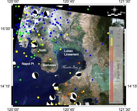
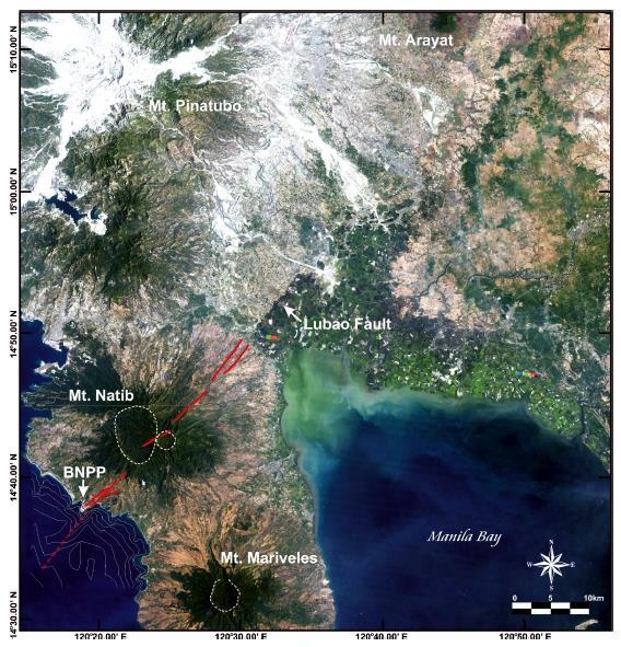
2 ~33 km Natib Volcano BNPP ~25 km Mariveles Volcano
3 Knowledge Much of scientific understanding of volcanism was learned only in the past 35 years. Eruption columns Pyroclastic Density currents

4 St. Pierre after the 8 May 1902 disaster

5

6

7
8 Released in October 2016
9
 4,060 years Mariveles Volcano (Siebert and Simkin, 2007) Geothermal activity 13 hot springs Indication of an active hydrothermal system in sampled")
10 27,000 yrs. based on carbon age dating (Newhall, personal communication from Volentik, 2009 ) 11,300 yrs 18,000 yrs (Cabato et. al) 4,060 years Mariveles Volcano (Siebert and Simkin, 2007) Geothermal activity 13 hot springs Indication of an active hydrothermal system in sampled hot springs (Ruaya, 1991)
11 A capable volcano or volcanic field is one that: (i) has a credible likelihood of experiencing future activity during the lifetime of the installation (ii) has the potential to produce phenomena that may affect the site of the installation. The designation of a volcano as capable is not dependent only on the time elapsed since the most recent eruption of the volcano, but rather is dependent on the credibility of the occurrence IAEA, 2012
12 What probability constitutes serious radiological consequences In some States a value for the annual probability of 10-7 is used in the hazard assessment for external events as a reasonable basis to evaluate whether a volcano in the region could produce any type of activity in the future that could lead to serious radiological consequences(iaea 2012).
13 Capable volcano
14 Potential sources of future volcanic activity Evidence of current volcanic activity includes historical volcanic eruptions, ongoing volcanic unrest, an active hydrothermal system (e.g. the presence of fumaroles) and related phenomena. Evidence of an eruption in the past 2 Ma generally indicates that future volcanic activity remains possible IAEA, 2012

15 Potentially active
16 Natib Volcano 27,000 years (Newhall) 11,000 years (Cabato et al.) Active Hydrothermal activity Dearth of information on eruptive activity but enough information to consider to proceed to stage 3
17 Mariveles Volcano 5000 years (Siebert and Simke, 2002)
18 Modern Pinatubo eruptions ~33,000 BC ~15,000 BC (Sacobia Eruptive Period) ~7000 BC (Pasbul Eruptive Period). Its eruptions were as energetic, if not as voluminous as the Inararo eruptions. ~ BC (Crow Valley Eruptive Period). This and the Maraunot period's eruptions were smaller than the Inararo eruption but about 2 to 3 times as big as that of 1991 based on the pyroclastic flow runout distances and depths of valley filling. ~ BC (Maraunot Eruptive Period) ~AD 1500 (Buag Eruptive Period). Its eruptions were roughly the same size as those of eruption Newhall and Punongbayan, 1996
19 Capable volcano

20 BNPP Previously available hazard map

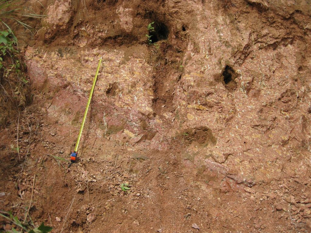
21 Updated Geological Map of Southwest Mount Natib Napot Point

22 Volcanic deposits

23

24

25
26

27

28
29 Nuee ardente advancing down the flank of Mt. Pelee. From Heilprin, 1908, The eruption of Mt. Pelee: Philadelphia Geographic Society, 72 p.

30

31

32 Surge

33 2.5X vertical exaggeration

34

35
36
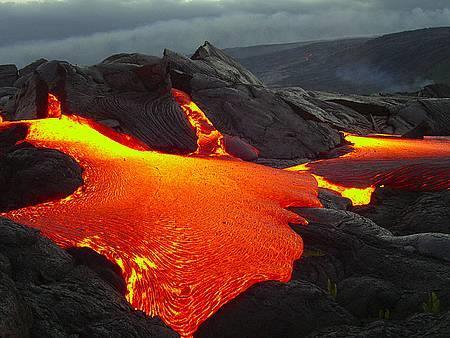
37 Hazards Lava flows Pyroclastic flows at least 5 pyroclastic flow deposits Pyroclastic surge Lahars
38 The probability of a future Natib eruption was calculated by Ebasco (1977) at 3 x 10 5 year- 1 and to be an order of magnitude greater by Volentik et al. (2009) at 1 x x 10-4 year -1, with a confidence level of 95%. These probabilities, together with Natib s active volcanic hydrothermal system (Ruaya & Panem 1991), means that Natib has credible potential for future eruption. Volentik et al. (2009) estimated an even higher probability for a VEI (Volcanic Explosivity Index) 6 7 eruption of Mariveles Volcano: 3.5 x x10-4 year -1, with a 95% confidence level.
39
40 IAEA, 2012

41 Pyroclastic Density Currents Considered as an exclusion condition at site selection stage? YES Can effects be mitigated by measures for design and operation? NO

42 Lava Flows Considered as an exclusion condition at site selection stage? YES Can effects be mitigated by measures for design and operation? NO
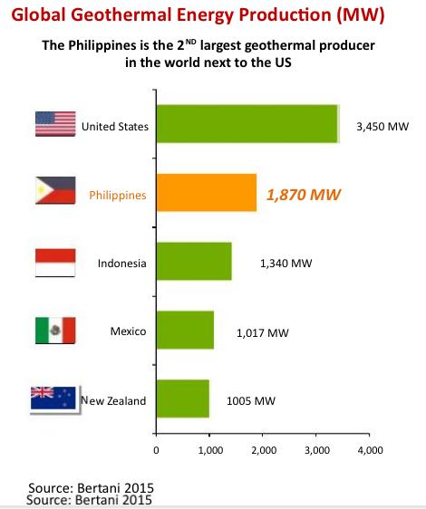
43
44 Lubao fault Soria (2009) formally named it the Lubao Lineament after the municipality where it is best expressed and argued that despite high sedimentation due to the Holocene eruptions of Mt Pinatubo, the wetland dryland boundary has been maintained because it is an active fault. Soria (2009) estimated that vertical components of motion at the lineament have dropped the southeastern block by as much as 3.5 m over the past 1.5 ka, based on palaeosea-level reconstructions from a peat layer taken in Lubao.
45

46

47

48

49

50

51 Geothermal Energy Source: Youtube
52 Renewable Energy Renewable Energy Act (2008) Accelerate the exploration and development of renewable energy resources such as, but not limited to, biomass, solar, wind, hydro, geothermal and ocean energy sources, including hybrid systems, to achieve energy self-reliance
53 Renewable Energy Climate Change Act (2009) It shall also be the policy of the State to incorporate a gender-sensitive, pro-children and pro-poor perspective in all climate change and renewable energy efforts
54

55

56 80 MW

57 MW

58 MW

59 MW

60
61 Advantages of Geothermal Energy to support industrialization We have the expertise in Geothermal We are rich in geothermal resources Disaster risk is very low Clean and renewable energy Energy source from all parts of the Philippines (Luzon, Visayas, Mindanao) Potential of up to MW Base load
62 Thank you for listening

63 Twenty-one time-series images from 19 March 2003 to 8 March 2006

64 Faults Natib Area of next slide

65
66
67
68 Radon Marikina Fault

69

70

71

72

73

74

75
76 Capable volcano: (1) may experience volcanic activity during the performance period of the nuclear installation; (2) such an event has the potential to produce phenomena that may affect the site of the nuclear installation (IAEA 2009).
77 Capability Age dates 27,000 yrs. based on carbon age dating (Newhall, personal communication from Volentik, 2009 ) 11,000 yrs - 4,060 years Mariveles Volcano (Siebert and Simkin, 2007) Geothermal activity 13 hot springs Indication of an active hydrothermal in sampled hot springs (Volentik citing Ruaya, 1991)
78 Annual probabilities of an eruption of Natib Ebasco (1977) at 3 X10⁻⁵ year -1 Volentik et al. (2009) at 1 X X 10-4 year -1, with a confidence level of 95% + Active hydrothermal system means it has credible potential for a future eruption
79 What probability constitutes serious radiological consequences In some States a value for the annual probability of 10-7 is used in the hazard assessment for external events as a reasonable basis to evaluate whether a volcano in the region could produce any type of activity in the future that could lead to serious radiological consequences(iaea 2009).
80 Capable volcano
81 Screening distance values the maximum distance from the source to the site at which each phenomenon could be a hazard Pyroclastic flow hazard within SDV Pyroclastic surge hazard within SDV Lahar hazard within SDV Lava flow hazard within SDV (nearest eruptive center 5 km away from the Nuclear reactor)
82

83


84 1982/12/29 Mw=5.5 Depth= 91.7 km
85 Capable faults are structures that are most relevant when evaluating the geological features of the site. They are faults that have a significant potential for relative displacement at or near the ground surface. Criteria 1.Shows evidence of past movement of a recurring nature within a period that it is reasonable to conclude that further movements at or near the surface may occur. In tectonically active areas, where both earthquake data and geological data consistently reveal short earthquake recurrence intervals, periods of the order of tens of thousands of years may be appropriate.
86 Capable faults are structures that are most relevant when evaluating the geological features of the site. They are faults that have a significant potential for relative displacement at or near the ground surface. Criteria: 2.A structural relationship with another known capable fault has been demonstrated, such that movement at one may cause movement of the other at or near the surface.
87
88 Conclusions site not suitable Pyroclastic flow hazard within SDV Pyroclastic surge hazard within SDV Lahar hazard within SDV Lava flow hazard within SDV (nearest eruptive center 5 km away from the Nuclear reactor) Seismic hazard seismically active area with the nearest identified fault 400 m away from the Nuclear reactor
Volcanic Hazards in Site Evaluation for Nuclear Installations
 DS405 Rev. 11 Date: 2011-05-27 IAEA SAFETY STANDARDS for protecting people and the environment Status: STEP 13 Establishing as an IAEA Safety Standards by the Publication Committee. Volcanic Hazards in
VOLCANO MONITORING PRACTICAL. Hazard alert levels established for communication at Mt. Pinatubo
 VOLCANO MONITORING PRACTICAL Predicting volcanic eruptions is a hazardous and stressful business. If an eruption has occurred and was not predicted then the volcanologists get the blame for not giving
Overview of Seismic and Volcanic Hazard Evaluation Methods for Nuclear Power Plants. Aybars Gürpinar, IAEA Consultant
 Overview of Seismic and Volcanic Hazard Evaluation Methods for Nuclear Power Plants REGIONAL WORKSHOP HANOI, VIETNAM, 7 11 JUNE 2010 Aybars Gürpinar, IAEA Consultant Background Information The following
Mount Pinatubo and the Ring of Fire
 Mount Pinatubo and the Ring of Fire Mount Pinatubo and the Ring of Fire On July 16, 1990, a large earthquake struck Luzon, an island in the Philippines. The earthquake devastated cities for hundreds of
FINAL EXAM December 20 th, here at 1:00 3:00 pm
 FINAL EXAM December 20 th, here at 1:00 3:00 pm REVIEW SESSION December 11 th at 6:00-7:30 pm Morrill I Auditorium (Room N375) Same as last time Don t forget your online course evaluations! Major Volcanic
Tectonic Processes and Hazards Enquiry Question 1: Why are some locations more at risk from tectonic hazards?
 Tectonic Processes and Hazards Enquiry Question 1: Why are some locations more at risk from tectonic hazards? Key words Basalt Andesite Rhyolite Benioff Zone Subduction zone Crustal fracturing Definition
Chapter Introduction Lesson 1 Earthquakes Lesson 2 Volcanoes Chapter Wrap-Up
 Chapter Introduction Lesson 1 Earthquakes Lesson 2 Volcanoes Chapter Wrap-Up What causes earthquakes and volcanic eruptions? What do you think? Before you begin, decide if you agree or disagree with each
Orting Community College Proposal
 Orting Community College Proposal Cedric, Celina, Francine, Sarah, Samuel GEO CORP Located in Washington, 42 miles south of Seattle. Situated between two rivers on fertile plains. Built on lahar deposits.
Debris Avalanches. Debris avalanche deposits on a volcano in Chile. All of the area in the foreground is buried by a thick debris avalanche.
 Debris Avalanches Volcanoes are not very stable structures. From time to time, they collapse producing large rock and ash avalanches that travel at high speeds down valleys. Collapse maybe caused by an
East Penn School District Curriculum and Instruction
 East Penn School District Curriculum and Instruction Curriculum for: Geology of National Parks Course(s): Geology of the National Parks Grades: 10-12 Department: Science Length of Period (average minutes):
SIO15 Midterm 1, Monday Oct. 29, 2018
 SIO15 Midterm 1, Monday Oct. 29, 2018 TEST VARIATION: B 1) Over the last 20 years, which of these natural disasters killed the most people in the U.S.? a) lightning strikes b) floods c) cold waves d) heat
New A-Level Physical Geography
 Half Term 1 3.1 Physical Geography: 3.1.5 Hazards: Plate Tectonics This optional section of our specification focuses on the lithosphere and the atmosphere, which intermittently but regularly present natural
Mt St Helens was know to have entered into active periods that lasted from years once every years over the last 500 years, (Figure 5).
.") Lecture #8 notes; Geology 3950, Spring 2006; CR Stern May 1980 eruption of Mt St Helens volcano (text pages 183-192 in the 4 th edition and 206-222 in the 5 th edition) Mt St Helens in southwest Washington
Lecture #8 notes; Geology 3950, Spring 2006; CR Stern May 1980 eruption of Mt St Helens volcano (text pages 183-192 in the 4 th edition and 206-222 in the 5 th edition) Mt St Helens in southwest Washington
( ) USGS (United States Geological Survey) Watch Green. Normal. alert level 1 Normal
 USGS (United States Geological Survey) Watch Green. Normal. alert level 1 Normal") (200610.1) USGS (United States Geological Survey) 1014 alert level 1 Normal Watch Green Normal USGS WARNING WATCH ADVISORY NORMAL SUMMARY OF VOLCANIC-ALERT LEVELS Highly hazardous eruption underway or
(200610.1) USGS (United States Geological Survey) 1014 alert level 1 Normal Watch Green Normal USGS WARNING WATCH ADVISORY NORMAL SUMMARY OF VOLCANIC-ALERT LEVELS Highly hazardous eruption underway or
Miami-Dade College. The student will demonstrate a basic knowledge of the origin and evolution of the Earth and its planetary environment.
 Miami-Dade College Common Course Number: GLY 3884 Course Title: Environmental Geology Catalog Course Description: This course focuses on the study of the application of geology to the interactions between
Jeopardy. Final Jeopardy $100 $100 $100 $100 $100 $200 $200 $200 $200 $200 $300 $300 $300 $300 $400 $400 $400 $500 $500 $500 $500 $500
 Jeopardy Earthquakes Volcanoes Tsunamis Wildfires Landslides/ Droughts $100 $100 $100 $100 $100 $200 $200 $200 $200 $200 $300 $300 $300 $300 $300 $400 $400 $400 $400 $400 $500 $500 $500 $500 $500 Final
Erupted and killed approximately 15,000 people 200 years ago
 1 2 3 4 5 6 7 8 Introduction to Environmental Geology, 5e Chapter 8 Volcanic Activity Volcanoes: summary in haiku form A volcano forms. Magma comes to the surface - explodes, if felsic. Case History: Mt.
On the Safety of the Bataan Nuclear Power Plant
 On the Safety of the Bataan Nuclear Power Plant Introduction Cutting to the chase: the Napot Point, Morong Bataan site has an unacceptably high risk of serious damage from earthquakes, volcanism, or both.
Hazard Resilience Index (HRI) Earthquakes, Tsunamis, and Volcanoes
 Earthquakes, Tsunamis, and Volcanoes") Hazard Index (HRI) Earthquakes, Tsunamis, and Volcanoes Earthquakes Tsunamis Volcano-Ash Falls, Projectiles and Lateral Blasts, Pyroclastic Flows and Lava Flows Earthquakes, Tsunamis and Volcanoes Please
Hazard Index (HRI) Earthquakes, Tsunamis, and Volcanoes Earthquakes Tsunamis Volcano-Ash Falls, Projectiles and Lateral Blasts, Pyroclastic Flows and Lava Flows Earthquakes, Tsunamis and Volcanoes Please
GLY July Ms. Nelda Breedt. Plates move slowly and eventually.
 GLY 162 Tectonic Processes: Volcanism Ms. Nelda Breedt GLY 162 Environmental Geology Plate Tectonics Plates move slowly and eventually. 2 Spread apart (divergent plates) Dive beneath one another (converging
Assessing the Volcanic Threat in Latin America. Jose L. Palma, University at Buffalo Bill Rose, Michigan Technological University
 Assessing the Volcanic Threat in Latin America Jose L. Palma, University at Buffalo Bill Rose, Michigan Technological University PASI Workshop, January 2011 Natural Disasters by Type, 1991-2005 90% 7%
Released Science Inquiry Task Encounter with an Active Volcano Grade 11
 Date: Your Name: Released Science Inquiry Task Encounter with an Active Volcano 2016 Grade 11 Directions: Science You will be reading a story and analyzing the data provided to answer a set of questions.
LECTURE #11: Volcanoes: Monitoring & Mitigation
 GEOL 0820 Ramsey Natural Disasters Spring, 2018 LECTURE #11: Volcanoes: Monitoring & Mitigation Date: 15 February 2018 I. What is volcanic monitoring? the continuous collection of one or more data sources
Volcanoes. 11/25/2013. Geology 15 Lecture 27 VOLCANO!
 Hazard Update Surprise POP Review Tsunami Activity 10 B Today s Material Volcanoes Volcanic Hazards Geology 15 Lecture 27 VOLCANO! http://motherboard.vice.com/blog/watch an erupting volcano create a newisland
Overview of Philippine Geohazards Programs
 Overview of Philippine Geohazards Programs 53 rd CCOP Annual Session CCOP-IUGS Task Group on Geohazards Joint Seminar Cebu City, PHILIPPINES October 18, 2017 Renato U. Solidum, Jr. Department of Science
Hazard assessment and risk mitigation for tourists at Hekla volcano, South Iceland. Jorge Montalvo Magnús Tumi Guðmundsson
 Hazard assessment and risk mitigation for tourists at Hekla volcano, South Iceland Jorge Montalvo Magnús Tumi Guðmundsson Volcandpark. Olot, Cataluña 25th of May 2012 1 Overview Introduction Classification
UGRC 144 Science and Technology in Our Lives/Geohazards
 UGRC 144 Science and Technology in Our Lives/Geohazards Session 6 Volcanic Hazards Lecturer: Dr. Patrick Asamoah Sakyi Department of Earth Science, UG Contact Information: pasakyi@ug.edu.gh College of
The Cascading Hazards from Cascadia s Earthquakes
 Tsunamis The Cascading Hazards from Cascadia s Earthquakes Earthquakes (Nisqually earthquake, Seattle, WA) Volcanoes (Mt St Helens eruption, WA) Joan Gomberg gomberg@usgs.gov Landslides (Oso landslide,
Name: Page 1. 2) What do increases and decreases in RSAM data indicate about magma movement inside the volcano?
 What do increases and decreases in RSAM data indicate about magma movement inside the volcano?") Name: Page 1 Living on the Edge Unit 5: SEISMOLOGISTS A report on the seismic activity must be prepared in order to assess and forecast future activity. Complete the following components of the seismology
Name: Page 1 Living on the Edge Unit 5: SEISMOLOGISTS A report on the seismic activity must be prepared in order to assess and forecast future activity. Complete the following components of the seismology
Progress Report: Sentinel Asia Success Story in the Philippines
 Progress Report: Sentinel Asia Success Story in the Philippines 3 rd Joint Project Team Meeting on the Sentinel Asia STEP-2 July 6-8, 2010 Hyatt Hotel, Manila, Philippines Renato U. Solidum Jr. Director
1) Which area has experienced the highest number of fatalities caused by natural disasters? a) North America b) Africa c) Europe d) Asia e) Australia
 Which area has experienced the highest number of fatalities caused by natural disasters? a) North America b) Africa c) Europe d) Asia e) Australia") SIO15 Midterm 1, Monday Oct. 29, 2018 TEST VARIATION: A 1) Which area has experienced the highest number of fatalities caused by natural disasters? a) North America b) Africa c) Europe d) Asia e) Australia
SIO15 Midterm 1, Monday Oct. 29, 2018 TEST VARIATION: A 1) Which area has experienced the highest number of fatalities caused by natural disasters? a) North America b) Africa c) Europe d) Asia e) Australia
GEOLOGY 285: INTRO. PETROLOGY
 Dr. Helen Lang Dept. of Geology & Geography West Virginia University SPRING 2015 GEOLOGY 285: INTRO. PETROLOGY The Cascade Volcanoes are a good example of the Circum- Pacific ring of fire of subductionrelated
Visualizing Earth Science. Chapter Overview. Volcanoes and Eruption Types. By Z. Merali and B. F. Skinner. Chapter 9 Volcanism and Other
 Visualizing Earth Science By Z. Merali and B. F. Skinner Chapter 9 Volcanism and Other Igneous Processes Volcanoes types and effects of eruption Chapter Overview Melting and cooling of rocks Geological
Volcanism (Chapter 5)
") GEOLOGY 306 Laboratory Instructor: TERRY J. BOROUGHS NAME: Volcanism (Chapter 5) For this assignment, you will require: a calculator, colored pencils, string, protractor, stereoscopes (provided). Objectives
GEOLOGY 306 Laboratory Instructor: TERRY J. BOROUGHS NAME: Volcanism (Chapter 5) For this assignment, you will require: a calculator, colored pencils, string, protractor, stereoscopes (provided). Objectives
NORTH VISTA SECONDARY SCHOOL HUMANITIES DEPARTMENT SECONDARY 3 EXPRESS HUMANITIES (GEOGRAPHY) 2272/02 CONTENT OUTLINE Term 1
 2272/02 CONTENT OUTLINE Term 1") NORTH VISTA SECONDARY SCHOOL HUMANITIES DEPARTMENT SECONDARY 3 EXPRESS HUMANITIES (GEOGRAPHY) 2272/02 CONTENT OUTLINE 2019 Term 1 Week Learning Outcomes Skills to be covered Assignment Test Project 1-2
NORTH VISTA SECONDARY SCHOOL HUMANITIES DEPARTMENT SECONDARY 3 EXPRESS HUMANITIES (GEOGRAPHY) 2272/02 CONTENT OUTLINE 2019 Term 1 Week Learning Outcomes Skills to be covered Assignment Test Project 1-2
19. Esan Continuously Monitored by JMA
 19. Esan Continuously Monitored by JMA Latitude: 41 48'17" N, Longitude: 141 09'58" E, Elevation: 618 m (Esan) (Triangulation Point) Overview of Esan, taken from east side on March 13, 2009 by the Japan
Benchmark A: Describe how the positions and motions of the objects in the universe cause predictable and cyclic events.
 Earth and Space Sciences Students demonstrate an understanding about how Earth systems and processes interact in the geosphere resulting in the habitability of Earth. This includes demonstrating an understanding
Name Class Date. Study Guide for 7 th Grade Final Exam (Semester One)
") Name Class Date Study Guide for 7 th Grade Final Exam (Semester One) 1. What are the steps of the scientific method? Define the problem or question Form a hypothesis (MUST BE TESTABLE) o (identify variables)
Name Class Date Study Guide for 7 th Grade Final Exam (Semester One) 1. What are the steps of the scientific method? Define the problem or question Form a hypothesis (MUST BE TESTABLE) o (identify variables)
From Punchbowl to Panum: Long Valley Volcanism and the Mono-Inyo Crater Chain
 From Punchbowl to Panum: Leslie Schaffer E105 2002 Final Paper Long Valley Volcanism and the Mono-Inyo Crater Chain Figure 1. After a sequence of earthquakes during the late 1970 s to the early 1980 s
FLANK COLLAPSE AND NEW RELATIVE INSTABILITY ANALYSIS TECHNIQUES APPLIED TO VOLCAN DE COLIMA AND MT ST. HELENS Lorenzo Borselli*, Damiano Sarocchi *
 FLANK COLLAPSE AND NEW RELATIVE INSTABILITY ANALYSIS TECHNIQUES APPLIED TO VOLCAN DE COLIMA AND MT ST. HELENS Lorenzo Borselli*, Damiano Sarocchi * *Instituto de Geología Universidad Autónoma de San Luis
All instruction should be three-dimensional. NGSS Example Bundles. Page 1 of 14
 Middle School Topic Model Course II Bundle 3 Geologic Changes to the Earth This is the third bundle of the Middle School Topics Model Course II. Each bundle has connections to the other bundles in the
Natural Hazards and Disaster
 Natural Hazards and Disaster Lab 7: Volcanoes and Land Slides (Question Set 5) Types of volcanoes Lahars Extreme eruptions Most common and deadly landslides Question Set 5: Volcanoes and Landslides 1 What
Volcanoes drive climate variability by
 Volcanoes drive climate variability by 1. emitting ozone weeks before eruptions, 2. forming lower stratospheric aerosols that cool Earth, 3. causing sustained ozone depletion, surface warming, and lower
GEOLOGY MEDIA SUITE Chapter 12
 UNDERSTANDING EARTH, SIXTH EDITION GROTZINGER JORDAN GEOLOGY MEDIA SUITE Chapter 12 Volcanoes 2010 W.H. Freeman and Company Plate tectonics explains the global pattern of volcanism. Key Figure 12.20 (page
Figure 8-21 Distribution of Lava Flow for the Model
 Figure 8-21 Distribution of Lava Flow for the Model 2) Pyroclastic Flow The energy cone model was used for the simulation. a. The angle of inclination of Energy Line, φ, from the summit was 5.3 degrees
2/25/2013. Volcanoes: summary in haiku form A volcano forms. Magma comes to the surface - explodes, if felsic.
 Introduction to Environmental Geology, 5e Edward A. Keller Chapter 8 Volcanic Activity Volcanoes: summary in haiku form A volcano forms. Magma comes to the surface - explodes, if felsic. Lecture Presentation
Science. Earth Science. New Jersey Quality Single Accountability Continuum (NJQSAC) Department: Course Title. Textbook(s): Focus on Earth Science
 Department: Course Title. Textbook(s): Focus on Earth Science") New Jersey Quality Single Accountability Continuum (NJQSAC) Textbook(s): Focus on Unit 1, September What is science? What is the Scientific Method? What is matter? How do atoms combine to form compounds?
New Jersey Quality Single Accountability Continuum (NJQSAC) Textbook(s): Focus on Unit 1, September What is science? What is the Scientific Method? What is matter? How do atoms combine to form compounds?
Latitude: 43 25'03" N, Longitude: '52" E, Elevation: 1,692 m (Maruyama) (Triangulation Point)
 (Triangulation Point)") 8.Maruyama Latitude: 43 25'03" N, Longitude: 143 01'52" E, Elevation: 1,692 m (Maruyama) (Triangulation Point) Overview of Maruyama taken from northwest side on July 2, 2007 by the Japan Meteorological
8.Maruyama Latitude: 43 25'03" N, Longitude: 143 01'52" E, Elevation: 1,692 m (Maruyama) (Triangulation Point) Overview of Maruyama taken from northwest side on July 2, 2007 by the Japan Meteorological
GEOLOGY 285: INTRO. PETROLOGY
 Dr. Helen Lang Dept. of Geology & Geography West Virginia University FALL 2005 GEOLOGY 285: INTRO. PETROLOGY Mount St. Helens 1980 Eruption Small earthquakes Small steam and ash eruptions in March and
3.2 Notes: Volcanoes Form as Molten Rock Erupts
 3.2 Notes: Volcanoes Form as Molten Rock Erupts Think about What happens when a volcano erupts? Volcanoes erupt many types of material Earth s thin outer layer is, but most of Earth is extremely hot rock
Land-use planning and volcanic hazards: Opportunities for New Zealand
 Land-use planning and volcanic hazards: Opportunities for New Zealand Julia Becker, Wendy Saunders, Graham Leonard, David Johnston, Lower Hutt Clare Robertson, Massey University, Palmerston North Presentation
Guidance for GEOGRAPHY End of Year Examination 2016
 Guidance for GEOGRAPHY End of Year Examination 2016 The End of Year Examination takes place in Week 4 of the Summer Term. The Geography Examination will last 50 minutes. The Examination will include questions
Correlation: California State Curriculum Standards of Science for Grade 6 Focus on Earth Science
 Correlation: California State Curriculum Standards of Science for Grade 6 Focus on Earth Science To Science Workshop Series Earth Science: Geology The Universe Oceans and Atmosphere Plate Tectonics and
They include earthquakes, volcanic eruptions, floods, landslides, and other processes and occurrences. They are included in the broader concept of.
 They include earthquakes, volcanic eruptions, floods, landslides, and other processes and occurrences. They are included in the broader concept of. In general, natural processes are labeled hazardous only
A New College in Orting?
 A New College in Orting? Risk Report and Recommendation by: Safe Schools Kause Everyone Deserves (SSKED) 2017 Geographic location and physical site of Orting The city of Orting is located in Pierce county,
L wave Lahar Lava Magma
 Very large collapsed volcanic crater, often containing a lake eg. Lake Taupo The process which provides the force to move the tectonic plates Innermost part of the Earth, made of a liquid outer core and
FIRST GRADE HAZARDS 1 WEEK LESSON PLANS AND ACTIVITIES
 FIRST GRADE HAZARDS 1 WEEK LESSON PLANS AND ACTIVITIES PLATE TECTONIC CYCLE OVERVIEW OF FIRST GRADE VOLCANOES WEEK 1. PRE: Learning the shapes of volcanoes. LAB: Experimenting with "lava." POST: Comparing
New Paltz Central School District
 Forces Shaping the Earth s Surface What are the structures of the Earth? What internal and external forces have shaped and continue to change the surface of the Earth? What are the impacts of these changes?
GEOTHERMAL ENERGY POTENTIAL FOR LONGONOT PROSPECT, KENYA. By Mariita N. O. Kenya Electricity Generating Company
 GEOTHERMAL ENERGY POTENTIAL FOR LONGONOT PROSPECT, KENYA By Mariita N. O. Kenya Electricity Generating Company PRESENTATION OUTLINE INTRODUCTION REGIONAL SETTING GEOLOGY GEOTHERMAL MANIFESTATIONS HYDROGEOLOGY
Introduction to Volcanic Seismology
 Introduction to Volcanic Seismology Second edition Vyacheslav M. Zobin Observatorio Vulcanolo'gico, Universidad de Colima, Colima, Col., Mexico ELSEVIER AMSTERDAM BOSTON HEIDELBERG LONDON * NEW YORK OXFORD
EARTH S SYSTEMS: PROCESSES THAT SHAPE THE EARTH
 9 Week Unit UNIT 2 EARTH S SYSTEMS: PROCESSES THAT SHAPE THE EARTH Fourth Grade Rogers Public Schools : Earth s Systems: Processes that Shape the Earth 9 weeks In this unit, students develop understandings
Science Colorado Sample Graduation Competencies and Evidence Outcomes
 Science Colorado Sample Graduation Competencies and Evidence Outcomes Science Graduation Competency 1 Physical Science Students know and understand common properties, forms, and changes in matter and energy.
Tectonic Hazard Evaluations for Korean Nuclear Sites
 Tectonic Hazard Evaluations for Korean Nuclear Sites June 13-17, 2011 Jakarta, INDONESIA Hyunwoo LEE (heanu@kins.re.kr) Korea Institute of Nuclear Safety 1 2 3 4 5 Introduction Tectonic Environment of
CAPE Unit 1 Module 2 & 3. Topic Specific Objectives Content Explain the main concepts, flows and processes associated with coastal environments
 # Week(s) Wks 1-3 CAPE Unit 1 Module 2 & 3 Topic Specific Objectives Content Explain the main concepts, flows and processes associated with coastal environments Wave formation, structure, types Textbook
WHAT YOU WILL LEARN. Key Concepts: TitleTitle Volcanoes and Global Warming. Carbon dioxide Sulfur dioxide Sulfate aerosols Greenhouse effect
 TitleTitle Volcanoes and Global Warming Key Concepts: Carbon dioxide Sulfur dioxide Sulfate aerosols Greenhouse effect WHAT YOU WILL LEARN 1. You will identify materials ejected by volcanic activity. 2.
SIO15 Midterm 1, Monday Oct. 30, 2017 TEST VARIATION: 2
 SIO15 Midterm 1, Monday Oct. 30, 2017 TEST VARIATION: 2 1) Over the last 20 years, which of these natural disasters killed the most people in the U.S.? a) heat waves b) hurricanes c) lightning strikes
Grades 9-12: Earth Sciences
 Grades 9-12: Earth Sciences Earth Sciences...1 Earth s Place in the Universe...1 Dynamic Earth Processes...2 Energy in the Earth System...2 Biogeochemical cycles...4 Structure and Composition of the Atmosphere...4
Chapter 5 9/10/2011. Introduction. Volcanoes and Volcanism. Volcanism. Introduction. Introduction. Introduction
 Introduction Chapter 5 Volcanism is the eruption of magma, and associated gases at the surface. Some magma erupts explosively as pyroclastic (fire-broken) rock and other erupts as lava flows. Volcanoes
Part A GEOLOGY 12 CHAPTER 4 WORKSHEET VOLCANOES. Name
 GEOLOGY 12 CHAPTER 4 WORKSHEET VOLCANOES Name Part A 1. The rough, jumbled blocky or jagged surface of a lava flow is called a. pahoehoe b. lahar c. aa d. phreatic 2. The Cascade volcanoes like Mt. St.
Volcanoes. volcanic hazards. Image courtesy of USGS.
 Volcanoes volcanic hazards Volcanic hazards Pyroclastic flows and surges Pyroclastic flows and surges PYROCLAST: all solid fragments ejected from volcanoes PYROCLASTIC FLOW: A flow of hot gas and volcanic
Climate forcing volcanic eruptions: future extreme event occurrence likelihoods
 Climate Change and Extreme Events: Managing Tail Risks Workshop 2 3 February 2010 Washington DC Climate forcing volcanic eruptions: future extreme event occurrence likelihoods Willy Aspinall with apologies
Chapter 2: Plate Tectonics: A Unifying Theory
 Chapter 2: Plate Tectonics: A Unifying Theory Chapter Outline 2.1 Introduction 2.2 Early Ideas About Continental Drift 2.3 What Is the Evidence for Continental Drift? 2.4 Features of the Seafloor 2.5 Earth
Volcano - A Volcano is an opening in the Earth s surface through which molten material or volcanic gases are erupted.
 What is a Volcano? Volcano - A Volcano is an opening in the Earth s surface through which molten material or volcanic gases are erupted. A volcano can either be a classic volcanic cone.. Mt. St. Helens,
Predicting the probability of Mount Merapi eruption using Bayesian Event Tree_Eruption Forecasting
 Predicting the probability of Mount Merapi eruption using Bayesian Event Tree_Eruption Forecasting Dyah Ika Rinawati *, Diana Puspita Sari, Naniek Utami Handayani, and Bramasta Raga Siwi Industrial Engineering
Geology and Earth Resources
 Geology and Earth Resources 1 A Layered Sphere Core dense, intensely hot metal! Mostly Fe and Ni! Inner and Outer Core Mantle - Hot, pliable layer, less dense! O 2, Si, Mg! Mesosphere (lower mantle)! Asthenosphere
Volcanoes. Introduction
 Volcanoes Introduction Display Slide V-0 Explain that a volcano is a vent through which molten rock escapes to the Earth s surface. Unlike other mountains, which are pushed up from below, volcanoes are
Use this checklist for revision. Combine with textbook, revision websites and revision guide.
 Paper 1: Tectonics Use this checklist for revision. Combine with textbook, revision websites and revision guide. Lesson Title Spec Point Keywords Case Studies/Key skills Practiced Exam Questions Revised?
SECONDARY EDUCATION CERTIFICATE LEVEL SAMPLE PAPER SEC 15
 MATRICULATION AND SECONDARY EDUCATION CERTIFICATE EXAMINATIONS BOARD UNIVERSITY OF MALTA SECONDARY EDUCATION CERTIFICATE LEVEL SAMPLE PAPER SEC 15 SUBJECT : PAPER NUMBER: DATE: TIME: GEOGRAPHY IIA Direction
Comprehensive Earth Science
 Comprehensive Earth Science COURSE DESCRIPTION: This course provides students with a comprehensive earth science curriculum, focusing on geology, oceanography, astronomy, weather, and climate. The program
Living on the Edge: Unit3: Convergent Plate Boundaries
 Living on the Edge: Unit3: Convergent Plate Boundaries Because of its eleva.on (4,392 m), relief, hydrothermal altera.on, ice cap, glacier- fed radial valleys, and proximity to suburbs of the SeaBle- Tacoma
2008 JC2 H2 GEOGRAPHY: PIONEER JUNIOR COLLEGE PRELIMINARY EXAMS. Figure 1 for Question 1
 PHYSICAL GEOGRAPHY Figure 1 for Question 1 Figure 2 for Question 2 Tropical air mass source regions Figure 3 for Question 3 Figure 4 for Question 4 Volcanic gases Figure 5 for Question 5 EITHER Photograph
CALIFORNIA CONTENT STANDARDS FOCUS ON EARTH SCIENCE, Grade 6. Correlated to AGS EARTH SCIENCE
 CALIFORNIA CONTENT STANDARDS FOCUS ON EARTH SCIENCE, Grade 6 Correlated to AGS EARTH SCIENCE PLATE TECTONICS AND EARTH S STRUCTURE 1. Plate tectonics accounts for important features of Earth s surface
INTRODUCTION TO VOLCANIC SEISMOLOGY
 INTRODUCTION TO VOLCANIC SEISMOLOGY V.M. Zobin Observatorio Vulcanologico, Colima, Mexico ELSEVIER Amsterdam - Boston - Heidelberg - London - New York - Oxford Paris - San Diego - San Francisco - Singapore
Physical Geography. Tectonics, Earthquakes, and Volcanism. Chapter 12 GEOGRAPHY Earthquakes and Volcanoes. What are Earthquakes?
 Physical Geography GEOGRAPHY 1710 DAVID R. SALLEE Tectonics, Earthquakes, and Chapter 12 Earthquakes and Volcanoes Earthquakes? The shaking or trembling caused by the sudden release of energy Usually associated
Topics: The Layers of the Earth and its Formation Sources of Heat Volcanos and Earthquakes Rock Cycle Rock Types Carbon Tax
 Topics: The Layers of the Earth and its Formation Sources of Heat Volcanos and Earthquakes Rock Cycle Rock Types Carbon Tax Essay Question on Carbon Tax 1. Drilling 2. Volcanic Activity 3. Laboratory experiments
General Oceanography Geology 105 Expedition 8 Plate Boundaries Beneath the Sea
 General Oceanography Geology 105 Expedition 8 Plate Boundaries Beneath the Sea Name Not attempting to answer questions on expeditions will result in point deductions on course workbook (two or more blank
Dynamic Planet PUT ALL YOUR ANSWERS ON THE ANSWER SHEET. c) low temperature d) high volatile content
 low temperature d) high volatile content") School Name: Team #: Students Names: Dynamic Planet 2016 Science Olympiad Invitational University of Texas at Austin PUT ALL YOUR ANSWERS ON THE ANSWER SHEET 1) Low viscosity magmas have: a) high silica
School Name: Team #: Students Names: Dynamic Planet 2016 Science Olympiad Invitational University of Texas at Austin PUT ALL YOUR ANSWERS ON THE ANSWER SHEET 1) Low viscosity magmas have: a) high silica
Images from: Boston.com
 Images from: Boston.com Ireland in the shadow of a volcano: Understanding the 2010 eruption at Eyjafjallajökull, Iceland. Chris Bean, School of Geological Sciences, UCD. World Quakes and Volcanoes 1960-2010
Also, when Cascade volcanoes do erupt, high-speed avalanches of pyroclastic flows
 INTRODUCTION A volcano is a vent through which molten rock escapes to the Earth s surface. Unlike other mountains, which are pushed up from below, volcanoes are built by surface accumulation of their eruptive
Geoscience 106 syllabus (fall offering)
") Geoscience 106 syllabus (fall offering) Environmental Geology Class meetings: Three 50-minute meetings per week, typically MWF 9:55-10:45 A.M. Classroom: AB20 Weeks Hall Textbook: Environmental Geology
Geoscience 106 syllabus (fall offering) Environmental Geology Class meetings: Three 50-minute meetings per week, typically MWF 9:55-10:45 A.M. Classroom: AB20 Weeks Hall Textbook: Environmental Geology
CATACLYSMIC ERUPTIONS
 CATACLYSMIC ERUPTIONS The really big ones! This figure compares the size of some recent, well-known eruptions. Note how small the eruptions of Mount St. Helens and even Vesuvius are compared to Katmai,
!!!!! STOP!!!!! What is environmental geology? Earth as a closed system implies nearly everything is cycled, recycled
 What is environmental geology?!!!!! STOP!!!!! Geology Study of rocks and minerals that comprise earth s surface and interior and the natural processes that shape the earth s surface and interior over all
!!!!! STOP!!!!! What is environmental geology?
 !!!!! STOP!!!!! What is environmental geology? Geology Study of rocks and minerals that comprise earth s surface and interior and the natural processes that shape the earth s surface and interior over
The Orting Community College of Vulcanology
 The Orting Community College of Vulcanology A Recommendation For His Honourable Mayor A. Young By DAG (Doom-and-Gloom), LLP (Michael, Chris, Bryan, Lauren, Dave) Agenda 1. 2. 3. 4. 5. 6. Description of
Dr. Yildirim Dilek Department of Earth Sciences Miami University, USA
 Dr. Yildirim Dilek Department of Earth Sciences Miami University, USA 40 years of successful, field-based, inter-disciplinary exploration of the Earth processes and training of the future generations of
Evidence for plate tectonics
 Evidence for plate tectonics See class powerpoint Printed tables 2x essay Qs markschemes Discuss/Evaluate the evidence for plate tectonics Discuss/evaluate the evidence for plate tectonics Essay: To what
EAS 116 Earthquakes and Volcanoes
 EAS 116 Earthquakes and Volcanoes J. Haase Forecasting Volcanic Eruptions Assessment of Volcanic Hazard Is that volcano active? Mount Lassen: 12000 BP and 1915 Santorini, IT: 180,000 BP, 70,000 BP, 21000
Volcanic Benefits & Forecasting
 Volcanic Benefits & Forecasting Review: https://www.youtube.com/watch?v=ydy28qtdyjy 1. Based on what we know about volcanoes, predict where you might you expect to see volcanoes in and around New Zealand?
Chapter 3 HAZARD ASSESSMENT AND PREDICTION. 3.1 General principles
 Chapter 3 HAZARD ASSESSMENT AND PREDICTION 3.1 General principles For long-term planning of human settlements and investment in volcanic areas, it is useful, and indeed essential, to have some knowledge
PLATE TECTONIC PROCESSES
 Lab 9 Name Sec PLATE TECTONIC PROCESSES 1. Fill in the blank spaces on the chart with the correct answers. Refer to figures 2.3, 2.4 p.33 (2.2 and 2.3 on p. 23) as needed. 2. With your knowledge of different