DEEP-SEATED SPREADING MODEL TESTED ON ETNA MOUNT WITH FEM
|
|
|
- Valentine Wilkerson
- 5 years ago
- Views:
Transcription

1 Presented at the COMSOL Conference 2008 Hannover DEEP-SEATED SPREADING MODEL TESTED ON ETNA MOUNT WITH FEM Pulvirenti F.* 1,2, Aloisi M. 1, Mattia M. 1 and Monaco C. 2 1 Istituto Nazionale di Geofisica e Vulcanologia, Catania, Italy 2 Dip. di Scienze Geologiche, Università di Catania, Catania, Italy * Corresponding author: INGV, Piazza Roma 2, 95123, Catania - Italy, fabiopulvirenti@yahoo.it
 1980 Eruption 450 m of the summit was removed by slope failure The common factor of these volcanoes is to lie on very active tectonic systems, regardless of the presence of a")
2 The sliding of volcano s flank is a phenomenon that occurs for different volcanoes in the word. Spectacular examples are: Socompa (Chile) Bandai-san and Ontake (Japan) Mount. St.Helens (Washington) 1980 Eruption 450 m of the summit was removed by slope failure The common factor of these volcanoes is to lie on very active tectonic systems, regardless of the presence of a magmatic complex inside. Among instable volcanoes, particular attention should be paid for Etna.


3 The Etna volcano: structural scenario Mount Etna is located in a particular tectonic position on the west side of the Ionian coast, where the Messina- Fiumefreddo system and the Malta escarpment intersect each other, and on the collision zone between the African plate and the Euro- Asiatic one. Its activity is moreover affected by the opening of the Siculo-Calabrian Rift in WNW-ESE direction.


4 The east flank of Etna is characterized by several active faults associated with middle-low sismic activity of low ipocentral depth and by the presence of a great volcano tectonic depression known as Valle del Bove. In the last 20 years several geodetic networks have been installed on Etna mount. The data acquired show that the eastern flank of Etna is unstable and is moving towards the sea. This behaviour is also confirmed by other techniques as SAR interferometry. Ground deformation velocity [After Puglisi et al.,2005]
5 Cinematics of the eastern Etna flank


6 EDM data GPS permanent network data >Horizontal slip rates of some cm/year (especially along the coast); >The displacement vectors along the coast are always directed towards east or southeast independently from inflation/deflation of the volcanic edifice; >Displacements cannot be attributed to tectonic processes only because these would imply slip rates of some mm/year.
7 Possible causes

![, 1992; Rust and Neri, 1996; Tibaldi and Groppelli, 2002; Neri et al., 2005; Rust et al., 2005] Tectonics block movements model [Monaco et al.](/docs-images/80/81562631/images/8-3.jpg ", 1995; 1997; 2005] After Tibaldi & Groppelli 2002 Other models: inflation/deflation processes, regional uplift with tilting or sea level rising with")
8 Several models have been proposed using geological and geophysical data Shallow sliding model [Labaume et al., 1990; Lo Giudice & Rasà, 1992; Rasà et al., 1996; Puglisi & Bonforte, 2004]. Deep-seated spreading model [Borgia et al., 1992; Rust and Neri, 1996; Tibaldi and Groppelli, 2002; Neri et al., 2005; Rust et al., 2005] Tectonics block movements model [Monaco et al., 1995; 1997; 2005] After Tibaldi & Groppelli 2002 Other models: inflation/deflation processes, regional uplift with tilting or sea level rising with erosion of the coast. [Labaume et al., 1990 Montalto et al, 1996; Firth et al., 1996)]
9 The deep-seated spreading model


10 The model, formulated originally by Borgia et al. 1992, is based on the study of the Hawaiian volcanoes (Poàs and Kilauea). According to the model Etna Mount is divided in five blocks on the base of the different slip rates observed. Different phases can be summarized: Magma uprising from the upper mantle to the crust on the west border of a PC; Pernicana Push of a dike complex (located 2-5 Km b.s.l.) over a thrust fault; Increasing of the Coulomb stress at the faults; Sequential movement of the blocks; Ragalna Trecast-Masc S.Venerina Extensional movements in the summit area and compressive one at the base of the east and south flanks are generated with formation of anticlinal folds near Misterbianco-Paternò and off-shore.
11 The deep seated spreading model tested with FEM

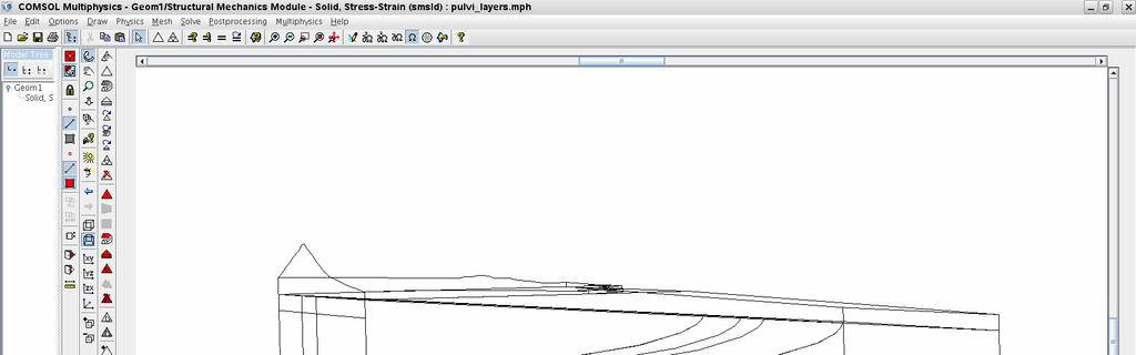
12 Step 1 : Creation of the geometry Using a specific script the Etna DEM is converted in ASCII STL format. The STL file is then imported. DEM resolution is 200 m Total domain dimension: 40x40 Km


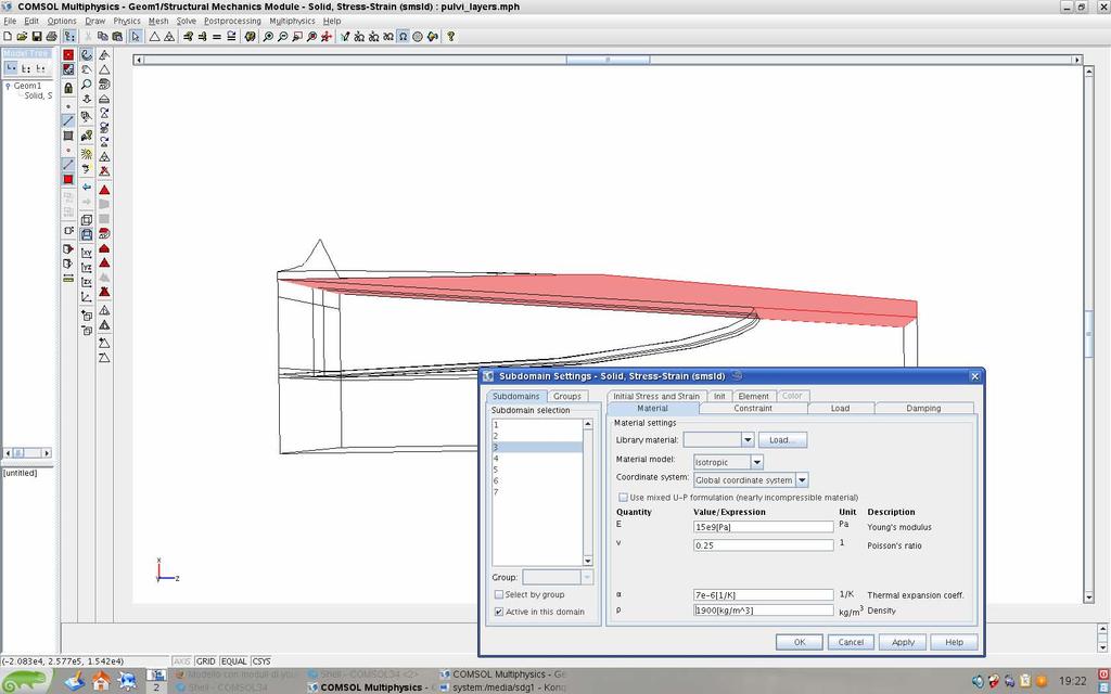
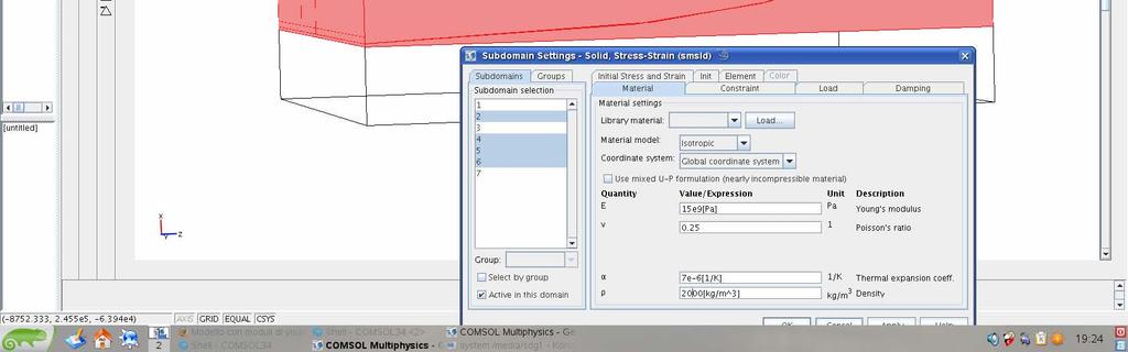

13 Step 2: The Subdomain Setting


14 Step 3: Boundary conditions and contact setting Contact For para > 1 a push of 100 cm is applied.

15 Step 4: Load parametrization Through the ampli2 function the load grows linearly when para is <=1 and is mantained at 100% when para is greater than 1

16 Step 5: Mesh generation Total degrees of freedom :80232 Swept tool used


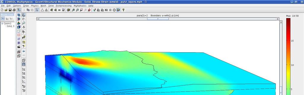
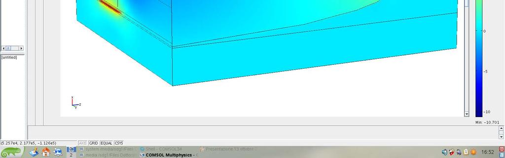
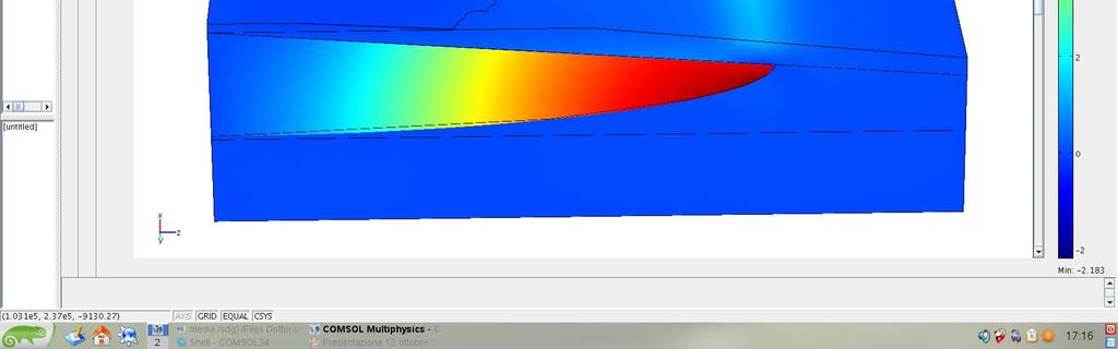
17 Step 6: Results and post processing Vertical Horizontal component
18 Discussion FEM Model results: The greatest displacements are observed in the Valle del Bove and in the final part of the ramp (anticlinal folds forming?); The uplift is one order greater than the horizontal components; Along the coast, an uplift of about 5 cm and an eastward movement of about 1 cm is observed; Observed GPS data: Valle del Bove is not covered by GPS network. Usually, during inflation periods, variations of some cm are recorded around it. The presence of anticlinal folds off-shore is still debated in literature; The horizontal component is one order greater than the vertical one; A downlift of about 2 cm and an eastward movement of about 3 cm is observed along the coast;
19 Conclusion Important differences are observed between FEM model results and recorded derformation pattern; The FEM model needs to be upgraded with structural and stratigraphical elements; Viscoelastic and elasto-plastic regimes could be tested; Complete Etna DEM; Work in progress Addition of the High Velocity Body (Plutonic Complex); Addition of the principal faults: Pernicana, S.Venerina, Trecastagni Mascalucia, Ragalna;
20 THE END Acknowledgments. We are very grateful to Gianluigi Zanotelli and Valerio Marra (COMSOL Italy) for the productive discussions and for all the hours dedicated to the model developing.
21 DEFORMATION THEORY AND STRAIN PARAMETERS By the Jacobian of the trasformation from the coordinate space (x,y) to the displacement space (u,v) we get (avoiding the rotational part) the strain tensor [Livieratos, 1980]: e ij = e ji exx = 1 Y e Y yy 2 e xx =ΔL/L (East strain) (>0 for extension) e yy =ΔL/L (North strain) (>0 for extension) γ 2 = e xy + e yx shear through each line parallel to the east axis (>0 for right lateral shear) γ 1 = exx e yy shear through each line parallel to NW-SE direction (>0 for right lateral shear) e xy= e yx shear through each line parallel to the east direction (>0 for right lateral shear) Δ = e xx + e yy Areal dilatation: area on area unit variation (>0 for area increasing). Considering a network with n baselines, the strain tensor parameters are calculated from the minimum squares solution of the system defined by n equations of the type:[livieratos,1980] e n = e xx sin ( α ) + Y sin(2α ) + e n 2 n yy cos 2 ( α ) n en is the strain of the n baseline with an azimuth (αn) respect to the north and obtained comparing the misures on two subsequent campaigns.
3D temporal evolution of displacements recorded on Mt. Etna from the 2007 to 2010 through the SISTEM method
 3D temporal evolution of displacements recorded on Mt. Etna from the 2007 to 2010 through the SISTEM method Bonforte A., Guglielmino F.,, Puglisi G. INGV Istituto Nazionale di Gofisica e vulcanologia Osservatorio
A finite element test of the Etna eruption
 Excerpt from the Proceedings of the COMSOL Conference 2009 Milan A finite element test of the 2002-2003 Etna eruption Pulvirenti F. *,1,2, Aloisi M. 1, De Guidi G. 2, Mattia M. 1 and Monaco C. 2 1 Istituto
Kinematics and strain analyses of the eastern segment of the Pernicana Fault (Mt. Etna, Italy) derived from geodetic techniques ( )
 derived from geodetic techniques ( )") ANNALS OF GEOPHYSICS, VOL. 49, N. 4/5, August/October 2006 Kinematics and strain analyses of the eastern segment of the Pernicana Fault (Mt. Etna, Italy) derived from geodetic techniques (1997-2005) Mimmo
ANNALS OF GEOPHYSICS, VOL. 49, N. 4/5, August/October 2006 Kinematics and strain analyses of the eastern segment of the Pernicana Fault (Mt. Etna, Italy) derived from geodetic techniques (1997-2005) Mimmo
Application of differential SAR interferometry for studying eruptive event of 22 July 1998 at Mt. Etna. Abstract
 Application of differential SAR interferometry for studying eruptive event of 22 July 1998 at Mt. Etna Coltelli M. 1, Puglisi G. 1, Guglielmino F. 1, Palano M. 2 1 Istituto Nazionale di Geofisica e Vulcanologia,
Feedback processes between magmatic events and flank movement at Mount Etna (Italy) during the eruption
 during the eruption") JOURNAL OF GEOPHYSICAL RESEARCH, VOL. 110,, doi:10.1029/2005jb003688, 2005 Feedback processes between magmatic events and flank movement at Mount Etna (Italy) during the 2002 2003 eruption Thomas R. Walter,
JOURNAL OF GEOPHYSICAL RESEARCH, VOL. 110,, doi:10.1029/2005jb003688, 2005 Feedback processes between magmatic events and flank movement at Mount Etna (Italy) during the 2002 2003 eruption Thomas R. Walter,
Mountains are then built by deforming crust: Deformation & Mountain Building. Mountains form where stresses are high!
 Deformation & Mountain Building Where are mountains located? Deformation and Folding Mountain building Mountains form where stresses are high! Mountains form at all three types of plate boundaries where
Unit 4 Lesson 7 Mountain Building
 Indiana Standards 7.2.4 Explain how convection currents in the mantle cause lithospheric plates to move causing fast changes like earthquakes and volcanic eruptions, and slow changes like creation of mountains
Answers: Internal Processes and Structures (Isostasy)
") Answers: Internal Processes and Structures (Isostasy) 1. Analyse the adjustment of the crust to changes in loads associated with volcanism, mountain building, erosion, and glaciation by using the concept
Answers: Internal Processes and Structures (Isostasy) 1. Analyse the adjustment of the crust to changes in loads associated with volcanism, mountain building, erosion, and glaciation by using the concept
What is the Relationship between Pressure & Volume Change in a Magma Chamber and Surface Deformation at Active Volcanoes?
 SSAC-pv2007.QE522.PL1.1 What is the Relationship between Pressure & Volume Change in a Magma Chamber and Surface Deformation at Active Volcanoes? What factors control the magnitude of surface deformation?
3. PLATE TECTONICS LAST NAME (ALL IN CAPS): FIRST NAME: PLATES
: FIRST NAME: PLATES") LAST NAME (ALL IN CAPS): FIRST NAME: PLATES 3. PLATE TECTONICS The outer layers of the Earth are divided into the lithosphere and asthenosphere. The division is based on differences in mechanical properties
LAST NAME (ALL IN CAPS): FIRST NAME: PLATES 3. PLATE TECTONICS The outer layers of the Earth are divided into the lithosphere and asthenosphere. The division is based on differences in mechanical properties
Chapter 16. Mountain Building. Mountain Building. Mountains and Plate Tectonics. what s the connection?
 Chapter 16 Mountains and Plate Tectonics what s the connection? Mountain Building Most crustal deformation occurs along plate margins. S.2 Active Margin Passive Margin Mountain Building Factors Affecting
Living in the shadow of Italy's volcanoes
 Living in the shadow of Italy's volcanoes Where is Mount Etna? Mount Etna is located on the east coast of Sicily roughly midway between Messina and Catania (Figure 1). It is the largest and tallest volcano
Dipartimento di Scienze Biologiche, Geologiche e Ambientali, Sezione di Scienze della Terra, Università di Catania, Italy 2
 Structural pattern and active deformation in the northern sector of the Aeolian-Tindari-Letojanni fault system in the geodynamic framework of the southern Calabrian Arc: an integrated analysis of field,
Chapter 4 Section 3, 4. Deforming the Earth s Crust
 Chapter 4 Section 3, 4 Deforming the Earth s Crust Deformation The process by which the shape of a rock changes because of stress Stress The amount of force per unit area on a given material Compression
ANOTHER MEXICAN EARTHQUAKE! Magnitude 7.1, Tuesday Sept. 19, 2017
 ANOTHER MEXICAN EARTHQUAKE! Magnitude 7.1, Tuesday Sept. 19, 2017 Why is there no oceanic crust older than 200 million years? SUBDUCTION If new oceanic crust is being continuously created along the earth
Stress and Strain. Stress is a force per unit area. Strain is a change in size or shape in response to stress
 Geologic Structures Geologic structures are dynamically-produced patterns or arrangements of rock or sediment that result from, and give information about, forces within the Earth Produced as rocks change
Interaction between magma intrusion and flank dynamics at Mt. Etna in 2008, imaged by integrated dense GPS and DInSAR data
 Article Volume 14, Number 8 6 August 2013 doi: ISSN: 1525-2027 Interaction between magma intrusion and flank dynamics at Mt. Etna in 2008, imaged by integrated dense GPS and DInSAR data Alessandro Bonforte,
Lecture 6 Folds, Faults and Deformation Dr. Shwan Omar
 Fold: A fold is a bend or wrinkle of rock layers or foliation; folds form as a sequence of ductile deformation. Folding is the processes by which crustal forces deform an area of crust so that layers of
4 Deforming the Earth s Crust
 CHAPTER 7 4 Deforming the Earth s Crust SECTION Plate Tectonics BEFORE YOU READ After you read this section, you should be able to answer these questions: What happens when rock is placed under stress?
Crustal Activity. Plate Tectonics - Plates - Lithosphere - Asthenosphere - Earth s surface consists of a major plates and some minor ones
 Name: Date: Period: Tectonics The Physical Setting: Earth Science CLASS NOTES Tectonics - s - Lithosphere - Asthenosphere - Earth s surface consists of a major plates and some minor ones The plates are
Flank instability on Mount Etna: radon, radar interferometry. and geodetic data from the south-western boundary. of the unstable sector
 Flank instability on Mount Etna: radon, radar interferometry and geodetic data from the south-western boundary of the unstable sector Marco Neri (1) *, Francesco Guglielmino (1) and Derek Rust (2) 1 Istituto
Plate Tectonics. Structure of the Earth
 Plate Tectonics Structure of the Earth The Earth can be considered as being made up of a series of concentric spheres, each made up of materials that differ in terms of composition and mechanical properties.
Deformation of the Crust
 Deformation of the Crust Review Choose the best response. Write the letter of that choice in the space provided. 1. The state of balance between the thickness of the crust and the depth at which it rides
How to Build a Mountain and other Geologic Structures. But first a short review
 How to Build a Mountain and other Geologic Structures But first a short review Where do we see deep earthquakes? What is happening there? What can happen at a plate boundary? 1. Plates can move apart
Earth Movement and Resultant Landforms
 Earth Movement and Resultant Landforms Structure of the Earth Lithosphere : earth s crust Asthenosphere : upper mantle zone where material is near its melting point & acts almost like liquid (appprox.
Directed Reading. Section: How Mountains Form MOUNTAIN RANGES AND SYSTEMS. Skills Worksheet
 Skills Worksheet Directed Reading Section: How Mountains Form 1. How high is Mount Everest? a. about 1980 km above sea level b. more than 8 km below sea level c. more than 8 km above sea level d. more
San Andreas Movie Can It Happen?
 San Andreas Movie Can It Happen? Learning Objectives (LO) Lecture 14: Faults and Quakes Read: Chapter 10 and 11 Homework #12 due Thursday 12pm What we ll learn today:! 1. Compare strike-slip to dip-slip
Mission to Mars! IS EARTH THE ONLY PLANET TO EXPERIENCE PLATE TECTONICS?
 Mission to Mars! IS EARTH THE ONLY PLANET TO EXPERIENCE PLATE TECTONICS? PLATE TECTONICS Earth s crust is split up into several tectonic plates which are constantly moving around (about the same speed
Section 2: How Mountains Form
 Section 2: How Mountains Form Preview Objectives Mountain Ranges and Systems Plate Tectonics and Mountains Types of Mountains Objectives Identify the types of plate collisions that form mountains. Identify
Deformation of Rocks. Orientation of Deformed Rocks
 Deformation of Rocks Folds and faults are geologic structures caused by deformation. Structural geology is the study of the deformation of rocks and its effects. Fig. 7.1 Orientation of Deformed Rocks
We are IntechOpen, the first native scientific publisher of Open Access books. International authors and editors. Our authors are among the TOP 1%
 We are IntechOpen, the first native scientific publisher of Open Access books 3,350 108,000 1.7 M Open access books available International authors and editors Downloads Our authors are among the 151 Countries
Movement of the Earth s Crust: Formation of: Mountain s Plateau's and Dome s
 Movement of the Earth s Crust: Formation of: Mountain s Plateau's and Dome s References Information taken from several places including Prentice Hall Earth Science: @ http://www.eram.k12.ny.us/education/components/docmgr/default.php?sectiondetaili
How mountains are made. We will talk about valleys (erosion and weathering later)
") How mountains are made We will talk about valleys (erosion and weathering later) http://www.ilike2learn.com/ilike2learn/mountainmaps/mountainranges.html Continent-continent plate convergence Less dense,
How mountains are made We will talk about valleys (erosion and weathering later) http://www.ilike2learn.com/ilike2learn/mountainmaps/mountainranges.html Continent-continent plate convergence Less dense,
Crustal Deformation. Earth Systems 3209
 Crustal Deformation Earth Systems 3209 Crustal Deformation pg. 415 Refers to all changes in the original form and/or size of a rock body. May also produce changes in the location and orientation of rocks.
1. occurs when the oceanic crust slides under the continental crust.
 1. occurs when the oceanic crust slides under the continental crust. 2. What type of stress is shown? 3. Where two plates slide past one another is called a boundary. 4. What type of stress is shown? 5.
Earth Dynamics. Landforms at Plate Boundaries
 Earth Dynamics CHAPTER 8 LESSON 2 Landforms at Boundaries What do you think? Read the two statements below and decide whether you agree or disagree with them. Place an A in the Before column if you agree
Chapter 10: Deformation and Mountain Building. Fig. 10.1
 Chapter 10: Deformation and Mountain Building Fig. 10.1 OBJECTIVES Describe the processes of rock deformation and compare and contrast ductile and brittle behavior in rocks. Explain how strike and dip
Earth Science Lesson Plan Quarter 3, Week 7, Day 1
 Earth Science Lesson Plan Quarter 3, Week 7, Day 1 Outcomes for Today Standard Focus: PREPARE 1. Background knowledge necessary for today s reading. Continental ice sheets increase the weight of the Earth
Plate Tectonics. entirely rock both and rock
 Plate Tectonics I. Tectonics A. Tectonic Forces are forces generated from within Earth causing rock to become. B. 1. The study of the origin and arrangement of Earth surface including mountain belts, continents,
GCSE Geology Plate Tectonics: Features and Processes
 GCSE Geology Plate Tectonics: Features and Processes A) DIVERGENT BOUNDARIES: 1. O-O Divergence, Example: The Mid-Atlantic Ridge, Iceland The North American and Eurasian Plates are moving away from each
Stress interaction between seismic and volcanic activity at Mt Etna
 Stress interaction between seismic and volcanic activity at Mt Etna Nathalie Feuillet, Massimo Cocco, Carla Musumeci, Concetta Nostro To cite this version: Nathalie Feuillet, Massimo Cocco, Carla Musumeci,
How to Build a Mountain and other Geologic Structures. But first, questions
 How to Build a Mountain and other Geologic Structures But first, questions Questions your students might ask How were Montana s mountains formed? How old are the mountains? What are the different ways
Geologic Structures. Changes in the shape and/or orientation of rocks in response to applied stress
 Geologic Structures Changes in the shape and/or orientation of rocks in response to applied stress Figure 15.19 Can be as big as a breadbox Or much bigger than a breadbox Three basic types Fractures >>>
Activity Pacific Northwest Tectonic Block Model
 Activity Pacific Northwest Tectonic Block Model The Cascadia tectonic margin is caught between several tectonic forces, during the relentless motions of the giant Pacific Plate, the smaller subducting
A) B) C) D) 4. Which diagram below best represents the pattern of magnetic orientation in the seafloor on the west (left) side of the ocean ridge?
 B) C) D) 4. Which diagram below best represents the pattern of magnetic orientation in the seafloor on the west (left) side of the ocean ridge?") 1. Crustal formation, which may cause the widening of an ocean, is most likely occurring at the boundary between the A) African Plate and the Eurasian Plate B) Pacific Plate and the Philippine Plate C)
1. Crustal formation, which may cause the widening of an ocean, is most likely occurring at the boundary between the A) African Plate and the Eurasian Plate B) Pacific Plate and the Philippine Plate C)
Convergent plate boundaries. Objective to be able to explain the formation and key features of these zones.
 Convergent plate boundaries Objective to be able to explain the formation and key features of these zones. Destructive plate margins When plates collide due to convection currents/slab pull in the asthenosphere
4 Deforming the Earth s Crust
 CHAPTER 7 4 Deforming the Earth s Crust SECTION Plate Tectonics BEFORE YOU READ After you read this section, you should be able to answer these questions: What happens when rock is placed under stress?
Geomechanical Modelling of the Mount Isa Copper Deposit
 Geomechanical Modelling of the Mount Isa Copper Deposit John G McLellan 1, 2, Rhonda O Sullivan 3, Brad Miller 4, Daniel Taylor 5 1. Principal Geoscience Consultant, GMEX, John@gmex.com.au. 2. Adjunct
Plate Tectonics and the cycling of Earth materials
 Plate Tectonics and the cycling of Earth materials Plate tectonics drives the rock cycle: the movement of rocks (and the minerals that comprise them, and the chemical elements that comprise them) from
11.1 Rock Deformation
 Tarbuck Lutgens Mountain Building 11.1 Rock Deformation Factors Affecting Deformation Factors that influence the strength of a rock and how it will deform include temperature, confining pressure, rock
Chapter 15 Structures
 Chapter 15 Structures Plummer/McGeary/Carlson (c) The McGraw-Hill Companies, Inc. TECTONIC FORCES AT WORK Stress & Strain Stress Strain Compressive stress Shortening strain Tensional stress stretching
Forces That Shape Earth. How do continents move? What forces can change rocks? How does plate motion affect the rock cycle?
 Forces That Shape Earth How do continents move? What forces can change rocks? How does plate motion affect the rock cycle? Plate Motion Mountain ranges are produced by plate tectonics. The theory of plate
Crustal Boundaries. As they move across the asthenosphere and form plate boundaries they interact in various ways. Convergent Transform Divergent
 Name: Date: Period: Plate Tectonics The Physical Setting: Earth Science CLASS NOTES Tectonic plates are constantly moving and interacting As they move across the asthenosphere and form plate boundaries
Shape Earth. Plate Boundaries. Building. Building
 Chapter Introduction Lesson 1 Lesson 2 Lesson 3 Lesson 4 Chapter Wrap-Up Forces That Shape Earth Landforms at Plate Boundaries Mountain Building Continent Building How is Earth s surface shaped by plate
Chapter 7 Plate Tectonics. Plate tectonics accounts for important features of Earth s surface and major geologic events.
 Chapter 7 Plate Tectonics Plate tectonics accounts for important features of Earth s surface and major geologic events. 7-2 Alfred Wegener s Hypothesis of Continental Drift (1915) He noticed that the continents
USU 1360 TECTONICS / PROCESSES
 USU 1360 TECTONICS / PROCESSES Observe the world map and each enlargement Pacific Northwest Tibet South America Japan 03.00.a1 South Atlantic Arabian Peninsula Observe features near the Pacific Northwest
Earthquake and Volcano Deformation
 Earthquake and Volcano Deformation Paul Segall Stanford University Draft Copy September, 2005 Last Updated Sept, 2008 COPYRIGHT NOTICE: To be published by Princeton University Press and copyrighted, c
Section 3 Deforming Earth s Crust
 Section 3 Deforming Earth s Crust Key Concept Tectonic plate motions deform Earth s crust. Deformation causes rock layers to bend and break and causes mountains to form. What You Will Learn Stress is placed
Mountains and Mountain Building: Chapter 11
 Mountains and Mountain Building: Chapter 11 Objectives: 1)Explain how some of Earth s major mountain belts formed 2) Compare and contrast active and passive continental margins 3) Explain how compression,
FORCES ON EARTH UNIT 3.2. An investigation into how Newton s Laws of Motion are applied to the tectonic activity on Earth.
 FORCES ON EARTH UNIT 3.2 An investigation into how Newton s Laws of Motion are applied to the tectonic activity on Earth. USE THESE NOTES: OUR HOME PLANET EARTH: What do you know about our planet? SO.HOW
Unit 4 Lesson 3 Mountain Building. Copyright Houghton Mifflin Harcourt Publishing Company
 Stressed Out How can tectonic plate motion cause deformation? The movement of tectonic plates causes stress on rock structures. Stress is the amount of force per unit area that is placed on an object.
Elastic Rebound Theory
 Earthquakes Elastic Rebound Theory Earthquakes occur when strain exceeds the strength of the rock and the rock fractures. The arrival of earthquakes waves is recorded by a seismograph. The amplitude of
Lecture Outline Friday March 2 thru Wednesday March 7, 2018
 Lecture Outline Friday March 2 thru Wednesday March 7, 2018 Questions? Lecture Exam Friday March 9, 2018 Same time, Same room Bring Pencils and WSU ID 50 question Multiple Choice, Computer Graded Interlude
December 21, Chapter 11 mountain building E.notebook. Feb 19 8:19 AM. Feb 19 9:28 AM
 Mountains form along convergent plate boundaries. Typically (usually) if you look at a mountain range, you know that it is at a plate boundary (active continental margin) or has been some time in the past
Lab 1: Plate Tectonics April 2, 2009
 Name: Lab 1: Plate Tectonics April 2, 2009 Objective: Students will be introduced to the theory of plate tectonics and different styles of plate margins and interactions. Introduction The planet can be
Learning Objectives (LO) What we ll learn today:!
 What we ll learn today:!") Learning Objectives (LO) Lecture 13: Mountain Building Read: Chapter 10 Homework #11 due Tuesday 12pm What we ll learn today:! 1. Define the types of stress that are present in the crust! 2. Define the
Learning Objectives (LO) Lecture 13: Mountain Building Read: Chapter 10 Homework #11 due Tuesday 12pm What we ll learn today:! 1. Define the types of stress that are present in the crust! 2. Define the
Lecture 9 faults, folds and mountain building
 Lecture 9 faults, folds and mountain building Rock deformation Deformation = all changes in size, shape, orientation, or position of a rock mass Structural geology is the study of rock deformation Deformation
Topics Laramide Orogeny: Late Cretaceous to Early Eocene Reading: GSA DNAG volume 3, Ch. 6
 Topics Laramide Orogeny: Late Cretaceous to Early Eocene Reading: GSA DNAG volume 3, Ch. 6 Late Cretaceous to early Eocene New patterns developed 5 main regions Tectonic interpretations Post-Laramide events
Layer Composition Thickness State of Matter
 Unit 4.2 Test Review Earth and Its Layers 1. Label the layers of the earth. oceanic crust continental crust lithosphere asthenosphere mantle outer core inner core 2. Complete the Following Table about
Plate Boundaries & Resulting Landforms
 Plate Boundaries & Resulting Landforms Divergent Plate Boundaries (plates being pulled apart) Type: oceanic plates Description: rising magma gently lifts the crust creating a ridge. The flow of convection
Plate Tectonics. Goal 2.1
 Plate Tectonics Goal 2.1 Lesson 1 Plate Tectonics: An Overview Think About It Look at the map below. Which two continents look like they d fit together? Focus Question How do Earth s tectonic plates cause
Chapter. Mountain Building
 Chapter Mountain Building 11.1 Rock Deformation Factors Affecting Deformation Factors that influence the strength of a rock and how it will deform include temperature, confining pressure, rock type, and
Ground displacement in a fault zone in the presence of asperities
 BOLLETTINO DI GEOFISICA TEORICA ED APPLICATA VOL. 40, N. 2, pp. 95-110; JUNE 2000 Ground displacement in a fault zone in the presence of asperities S. SANTINI (1),A.PIOMBO (2) and M. DRAGONI (2) (1) Istituto
Faults, folds and mountain building
 Faults, folds and mountain building Mountain belts Deformation Orogens (Oro = Greek all changes for mountain, in size, shape, genesis orientation, = Greek for or formation) position of a rock mass Structural
Earthquake and Volcano Clustering at Mono Basin (California)
") Excerpt from the Proceedings of the COMSOL Conference 2010 Paris Earthquake and Volcano Clustering at Mono Basin (California) D. La Marra *,1, A. Manconi 2,3 and M. Battaglia 1 1 Dept of Earth Sciences,
Excerpt from the Proceedings of the COMSOL Conference 2010 Paris Earthquake and Volcano Clustering at Mono Basin (California) D. La Marra *,1, A. Manconi 2,3 and M. Battaglia 1 1 Dept of Earth Sciences,
Plates Moving Apart Types of Boundaries
 Plates Moving Apart Types of Boundaries PLATE TECTONICS IS The theory that the Earth s crust is broken into slabs of rock that move around on top of the asthenosphere. How fast are plates moving? The Arctic
Chapter 1: Landforms Patterns & Processes. Pg
 Chapter 1: Landforms Patterns & Processes Pg. 10-21 Video Time Physical Geography (6:02) Introduction: Earth is dynamic it behaves as if it s a living organism. Some changes are rapid enough for us to
Crags, Cracks, and Crumples: Crustal Deformation and Mountain Building
 Crags, Cracks, and Crumples: Crustal Deformation and Mountain Building Updated by: Rick Oches, Professor of Geology & Environmental Sciences Bentley University Waltham, Massachusetts Based on slides prepared
Supporting the response to the 2018 lower East Rift Zone and summit collapse at Kīlauea Volcano, Hawaiʻi
 Hawaiʻi Supersite success story Supporting the response to the 2018 lower East Rift Zone and summit collapse at Kīlauea Volcano, Hawaiʻi Since 1983, Kīlauea Volcano, on the Island of Hawaiʻi, has actively
Captain s Tryouts 2017
 Captain s Tryouts 2017 Dynamic Planet Test Written by: Araneesh Pratap (Chattahoochee High School) Name: Date: Answer all questions on the answer sheet. Point values are given next to each question or
Lab 6: Plate tectonics, structural geology and geologic maps
 Geology 103 Name(s): Lab 6: Plate tectonics, structural geology and geologic maps Objective: To show the effects of plate tectonics on a large-scale set of rocks and to reconstruct the geological history
GEOL104: Exploring the Planets LAB 5: PLANETARY TECTONICS
 GEOL104: Exploring the Planets LAB 5: PLANETARY TECTONICS OBJECTIVES: I. Understand the three basic types of tectonic interactions that can occur II. Identify tectonic interactions on other planets MATERIALS:
1.4 Notes: Plates Converge or Scrape Past Each Other Think About Tectonic Plates Push Together at Convergent Boundaries
 1.4 Notes: Plates Converge or Scrape Past Each Other Think About If new crust is created at divergent boundaries, why does the total amount of crust on Earth stay the same? Tectonic Plates Push Together
Benjamin N. Cardozo Dynamic Planet Test
 Names: Score: /83 Benjamin N. Cardozo Dynamic Planet Test - Labeling Questions are worth 1 Point Each (1 point per labeled/identified item) - Multiple Choice Questions are worth 2 Points Each - Short Answer
Plate Tectonics Practice Test
 Plate Tectonics Practice Test 1. What is the main idea Alfred Wegner proposed in the Theory of Continental Drift that he published in 1915? a. The continents float on a liquid layer that allows them to
PEAT SEISMOLOGY Lecture 12: Earthquake source mechanisms and radiation patterns II
 PEAT8002 - SEISMOLOGY Lecture 12: Earthquake source mechanisms and radiation patterns II Nick Rawlinson Research School of Earth Sciences Australian National University Waveform modelling P-wave first-motions
12. The diagram below shows the collision of an oceanic plate and a continental plate.
 Review 1. Base your answer to the following question on the cross section below, which shows the boundary between two lithospheric plates. Point X is a location in the continental lithosphere. The depth
Mohorovicic discontinuity separates the crust and the upper mantle.
 Structure of the Earth Chapter 7 The Earth is divided into 3 Main Layers 1. Crust outermost layer 1% of the Earth s mass thickness varies: 5 100 km two types: oceanic denser continental Mohorovicic discontinuity
6. In the diagram below, letters A and B represent locations near the edge of a continent.
 1. Base your answer to the following question on the cross section below and on your knowledge of Earth science. The cross section represents the distance and age of ocean-floor bedrock found on both sides
Notepack # 9 AIM: Why are the continents drifting apart? Do Now: Watch the video clip and write down what you observe.
 Notepack # 9 AIM: Why are the continents drifting apart? Do Now: Watch the video clip and write down what you observe. http://www.youtube.com/watch?v=ci 5P5yy0xlg&feature=related What do we know as a class,
Plate Tectonics. I. The Discovery of Plate Tectonics II. A Mosaic of Plates III. Types of Plate Boundaries IV. How Plates Move
 Plate Tectonics I. The Discovery of Plate Tectonics II. A Mosaic of Plates III. Types of Plate Boundaries IV. How Plates Move I. The Discovery of Plate Tectonics A. Continental Drift (Alfred Wegener) Proposed
Earth Science, (Tarbuck/Lutgens) Chapter 10: Mountain Building
 Chapter 10: Mountain Building") Earth Science, (Tarbuck/Lutgens) Chapter 10: Mountain Building 1) A(n) fault has little or no vertical movements of the two blocks. A) stick slip B) oblique slip C) strike slip D) dip slip 2) In a(n) fault,
Earth Science, (Tarbuck/Lutgens) Chapter 10: Mountain Building 1) A(n) fault has little or no vertical movements of the two blocks. A) stick slip B) oblique slip C) strike slip D) dip slip 2) In a(n) fault,
Brittle Deformation. Earth Structure (2 nd Edition), 2004 W.W. Norton & Co, New York Slide show by Ben van der Pluijm
, 2004 W.W. Norton & Co, New York Slide show by Ben van der Pluijm") Lecture 6 Brittle Deformation Earth Structure (2 nd Edition), 2004 W.W. Norton & Co, New York Slide show by Ben van der Pluijm WW Norton, unless noted otherwise Brittle deformation EarthStructure (2 nd
Lecture 6 Brittle Deformation Earth Structure (2 nd Edition), 2004 W.W. Norton & Co, New York Slide show by Ben van der Pluijm WW Norton, unless noted otherwise Brittle deformation EarthStructure (2 nd
Chapter 2: Plate Tectonics: A Unifying Theory
 Chapter 2: Plate Tectonics: A Unifying Theory Chapter Outline 2.1 Introduction 2.2 Early Ideas About Continental Drift 2.3 What Is the Evidence for Continental Drift? 2.4 Features of the Seafloor 2.5 Earth
1. What is Wegener s theory of continental drift? 2. What were the 4 evidences supporting his theory? 3. Why wasn t Wegener s theory excepted?
 Notebook 7a and 7b Objective (left-side): Students will be able to explain the theory of plate tectonics and be able to make predictions about plate interactions. Mapping Reflection 1. What is Wegener
Chapter Review USING KEY TERMS. asthenosphere uplift continental drift. known as. tectonic plates move. object. UNDERSTANDING KEY IDEAS
 Skills Worksheet Chapter Review USING KEY TERMS 1. Use the following terms in the same sentence: crust, mantle, and core. Complete each of the following sentences by choosing the correct term from the
Lateral extrusion and tectonic escape in Ilan Plain of northeastern Taiwan
 Lateral extrusion and tectonic escape in Ilan Plain of northeastern Taiwan Angelier, J., Chang, T.Y., Hu, J.C., Chang, C.P., Siame, L., Lee, J.C., Deffontaines, B., Chu, H.T, Lu, C.Y., Does extrusion occur
NC Earth Science Essential Standards
 NC Earth Science Essential Standards EEn. 2.1 Explain how processes and forces affect the Lithosphere. EEn. 2.1.1 Explain how the rock cycle, plate tectonics, volcanoes, and earthquakes impact the Lithosphere.
Monitoring long-term ground movements and Deep Seated Gravitational
 Monitoring long-term ground movements and Deep Seated Gravitational Slope Deformations by InSAR time series: cases studies in Italy Salvatore Stramondo (1), M. Saroli (1, 2), M. Moro (1, 2), S. Atzori
Earth s Tectonic Plates
 MASTER 49 6.2 3.7 5.4 Philippine Pacific 5.4 North American Juan de Fuca Caribbean Cocos 10.0 9.2 2.3 2.5 2.3 1.8 3.0 Indian-Australian 10.5 7.1 17.2 16.8 6.0 Nazca South American 11.1 10.3 7.3 3.7 7.5