Geophysics Contribution for the Determination of Aquifers with a Case Study
|
|
|
- Briana Underwood
- 6 years ago
- Views:
Transcription
 Geophysics Contribution for the Determination of Aquifers with a Case Study Latifa Ouadif 1, Lahcen Bahi 1, Ahmed Akhssas 1, Khadija Baba 1, Med Menzhi 2 1 3GIE Laboratory,")
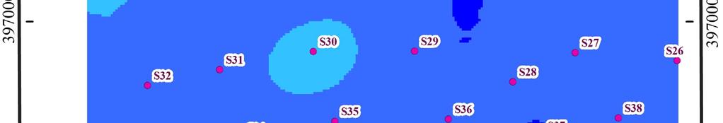
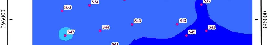
1 International Journal of Geosciences, 2012, 3, Published Online February 2012 ( Geophysics Contribution for the Determination of Aquifers with a Case Study Latifa Ouadif 1, Lahcen Bahi 1, Ahmed Akhssas 1, Khadija Baba 1, Med Menzhi 2 1 3GIE Laboratory, Mohammadia Engineering School, Mohammed V Agdal University, Rabat, Morocco 2 National Centre for Scientific and Technical Research, Mohammed V Souissi University, Rabat, Morocco ouadif@gmail.com Received September 24, 2011; revised November 23, 2011; accepted December 29, 2011 ABSTRACT The determination and monitoring of aquifer formations on the eastern border of Moroccan Gharb basin are very difficult because of their spatial and temporal variation. To delimit these formations, a geophysical survey of 52 geoelectric soundings was performed with a mesh of 500 m and electrodes distance between 1000 m and 3000 m. Geoelectric sections and resistivity maps show a horst and graben structure. The correlation of existing oil drillings shows that the Jurassic and Neogene formations are both affected by normal faults causing Jurassic deposits collapse with local thickening of the Miocene deposits, and reverse faults delimiting tectonic slices due to tension caused by prerifaine nappe advance. This fact confirms the generated structure by the resistivity method. The isobath map of resistant formations s roof show average depths extending from 400 to 800 m for calcareous sandstone that are potential aquifers while oil drillings indicate over 1000 m depths. Keywords: Aquifer; Prerifaine Nappe; Resistivity Method; Geophysical Survey; Gharb Basin 1. Introduction The Gharb Neogene basin is a collapse zone formed on the margins of the Rif s chain. The filling deposits of the basin are characterized by a vertical variation due to a regional geological context. The Gharb basin, which knew many subsidences during certain periods, with a paroxysm in the Pliocene, receives the prerifaine nappe which subdivides the Miocene in infra-nappe and supra-nappe Miocene [1-5]. The former works reflect the structural complexity of Gharb basin in general and particulary its eastern boundary. This makes the determination and monitoring of the formations, constituted by permeable deposits likely to correspond to aquiferous levels, very difficult [6-8]. The recognition of this limit is confronted with the difficulties posed by the lack of data and controversial interpretations about the structure of this limit [9,10]. Thus, it is necessary to conduct synthetic studies implying local geology, study of oil drillings and interpretation of all carried out geoelectric soundings. The realization of geoelectric sections and resistivity maps, combined with the correlations of stratigraphic drilling columns, allows elucidating the structure of the eastern boundary of the Gharb basin-prerifaine ridges which is affected by reverse faults due to prerifaine nappe advance in the basin and by the collapse normal faults. 2. Methodology The study purpose is to identify the major tectonic aspects of the eastern border of the Gharb basin with prerifaine ridges and find out the formations that may constitute potential aquifers levels. This approach required the interpretation of 52 geoelectric soundings with AB electrodes distance varying from 1000 to 3000 m, carried out in the Sidi Kacem region, and also to study the oil drills data in the same region that have provided a database on the petrographic facies of the Jurassic and Neogene deposits of the basin boundary with prérifaines ridges. North Eas- South West and North-South drillings correlations show lateral and vertical various formations evolution of this complex boundary. The electrical resistivity method is most used in engineering geology. It identifies and locates, from the earth surface, the structures which have resistivity contrasts [11,12]. It consists of conducting geoelectric sounding to determine, at several points, the vertical succession of layers of different resistivity. This method is based on the principle of Ohm s law: the injection in soil of a direct current at a very low frequency and then voltage measurement makes it possible to unveil the true resistivity of crossed formations. Several devices were used among which the most known is the Schlumberger one. In this device (Figure 1), we inject a current into two electrodes
2 118 L. OUADIF ET AL. A and B, and we measure the voltage at the receiving electrodes M and N. Apparent resistivity is given by: app L π l 2 2 2l V I or app V K I where K is the geometric factor that depends on electrodes spacing only. Our geophysical survey covers an area of 20 km 2 and includes 52 geoelectric soundings with a line AB length extending from 1000 to 3000 m (Figure 2). We interpreted these VES to determine the vertical succession of formations in place and have made geoelectric sections to Figure 1. Schlumberger array. show the lateral variation of facies. We have also made geological sections from oil drilling combined with geoelectric sections to correlate the different data and better approximate the limit structure between the prerifaines ridges and the Gharb Basin. 3. Results and Discussions 3.1. Geoelectric Soundings Interpretation Inverse modeling of the electrical resistivity data is done using the software IPI2WIN [13]. We distinguish four groups of geoelectric soundings that generally show respectively from top to bottom the following (Figure 3). Group 1 (Figure 3(a)): A thin clay layer; Sand with 60 m of average thickness; Thick layer of marl up to 400 m; Resistant layer formed by calcareous sandstone of the Miocene. Group 2 (Figure 3(b)): A thin clay layer; Figure 2. Location map of geoelectric soundings.
3 L. OUADIF ET AL. 119 (a) (b) (c) Figure 3. Interpretation of some geoelectric soundings. (d) A low resistance formation assigned to marly sands; A marly formation becomes a little stronger at depth; These geoelectric soundings have not reached the resistant sandstones of the Miocene. Group 3 Figure 3(c): A thin resistant cover made of conglomerates; Formations of sand little resistant; Marly formations that reach a depth of 150 m; A resistant formation formed by sandstone is reached at a shallow depth of about 200 m. Group 4 Figure 3(d): Thin clay formation; Sixty meters of sand and marl, which become stronger at depth. These geoelectric soundings have not reached the calcareous sandstone Geoelectric Cross Section The Neogene basin of the Gharb has become deformed at its borders what is due to tectonic movements of the Prerif and prerifaines ridges [14-17]. Geoelectric sections based on data from geoelectric soundings performed in two directions to identify the shape and structure of the border: A subparallel direction North East-South West to the ridge of Outita-Draa (Figure 4) and a North West-South East direction which is perpendicular to the ridge (Figure 5). The subparallel sections to the ridge show resistant formations with shape of horst and graben that sink deep leaving place for marly Neogene deposits. These marly deposits are very thick reaching 500 m in S4 in north of the study area. The perpendicular sections to the ridge also show the same structure of horst and graben. Approaching the ridge, the resistant complex is shallower; it is reached at 300 m Structural Analysis The structural analysis is based on the study of oil drillings. North East-South West correlations drillings show that the Jurassic and Neogene formations are affected by normal faults which cause a collapse of both sides of an upper area formed by Jurassic deposits (boreholes OT8 and KM5) with thickening of the Miocene, and reverse faults that delimit a tectonic slices. These reverse faults are mainly due to tension caused by the advance of the prerifaine nappe in the Neogene Gharb basin. However the geoelectric soundings show the heterogeneity of formations met in the south-east Jurassic ridge, which demonstrates the complexity of this area which is affected by normal and reverse faults delimiting horsts and grabens (Figure 6). The North-South correlations, also, show a thickening of the Miocene at the areas of collapse that is progressif from Outita link in South towards North in direction of center of Gharb basin. Reverse faults affecting the prerifaine nappe and Miocene deposits result from the deformation caused by the advance of the prerifaine nappe in Gharb basin (Figure 7) Map Resistivity The Resistivity maps for different lengths of lines AB also show the existence of faults and raising of Miocene marls which are conductives to the center of our area in a direction North West-South East (Figure 8). The resistivity map for AB = 200 m indicates that the surface formations are mainly marly except at the far North West where we are seeing more resistant formations that can be attributed to the sandy sandstone. The greater the length
![120 L. OUADIF ET AL. of line AB, where we reaches deeper formations [18,19], the most of Miocene marls appear in the middle of our zone in a North West-South East direction.](/docs-images/79/79067649/images/4-0.jpg "This confirms once again this tectonic as a horst and graben.")

. 4.")
4 120 L. OUADIF ET AL. of line AB, where we reaches deeper formations [18,19], the most of Miocene marls appear in the middle of our zone in a North West-South East direction. This confirms once again this tectonic as a horst and graben. The depth distribution map of the roof of the resistant complex which may constitute a potential aquifer shows that he is reached as lenses at shallow depths around 200 m in the central zone and the Far East. At South East, it is at great depths reaching 800 m, while in the rest of the area, it is reached at an average depth between 400 and 600 m (Figure 9). 4. Conclusion Gharb Basin has been the subject of several geological, geophysical and sedimentological studies; however, the eastern boundary of the basin remains unknown. The geoelectric survey has shown the geological complexity of this boundary. The geoelectric sections and resistivity maps show a structure in horst and graben. Oil drillings (a) (b) (c) Figure 4. North East-South West geoelectric sections, subparallel to Outita-Draa ridge.
 (b) (c) Figure 5.")


5 L. OUADIF ET AL. 121 (a) (b) (c) Figure 5. North Weast-South East geoelectric sections, perpendicular to Draa Outita ridge. Figure 6. North East-South West geological and geoelectric sections.


6 122 L. OUADIF ET AL. Figure 7. North South geological and geoelectric sections.


7 L. OUADIF ET AL. 123


8 124 L. OUADIF ET AL. Figure 8. Resistivity maps for AB = 200, 600, 1000 and Figure 9. Depth distribution map of resistant roof.
9 L. OUADIF ET AL. 125 correlations conducted in Sidi Kacem region show reverse faults affecting the Jurassic and the Neogene due to tension caused by the prerifaine nappe advance. This confirms the structure generated by the geoelectric survey. The originality of our work is the fact that the roof map of resistant layers gives average depths between 400 and 600 m for calcareous sandstone which could constitute potential aquifers as opposed to the oil drillings, which indicate depths over 1000 m. REFERENCES [1] P. Cirac, Le Bassin Sud-Rifain Occidental au Néogène Supérieur. Evolution de la Dynamique Sédimentaire et de la Pléogéographie au Cours d Une Phase de Comblement, Thèse d Etat, Université de Bordeaux I, 3 Tomes, [2] P. Cirac, Environnements Sédimentaires du Pliocène de la Bordure Pré-Rifaine du Gharb (Maroc Nord-Occidetal), Bulletin de la Société Géologique de France, Vol. 7, No. 3, 1978, pp [3] H. Feinberg, Les Séries Tertiaires des Zones Externes du Rif (Maroc), Notes et Mémoires du Service Géologique du Maroc, Vol. 315, 1986, p [4] W. Litto, Apport de la Sismique Réflexion et des Diagraphies à l Etude de l Evolution Géodynamique D un Bassin Néogène à Potentiel Pétrolier: Exemple de la Marge Nord du Bassin du Gharb (Avant Pays Rifain, Maroc), Thèse de Doctorat, Faculté des Sciences Rabat, Maroc, [5] Société Chérifienne des Pétroles (SCP), Carte Géologique du Gharb et Prérif Occidental, 1/200000, [6] A. Akhssas, Contribution à l Etude des Niveaux Sableux à Hydrocarbures du Miocène Post-Nappe du Bassin du Gharb (Maroc). Application de l Analyse Multidimensionnelle, Thèse d Etat, University Mohammed V-Agdal, [7] M. Boutakiout, Les Foraminifères Jurassiques des Rides sud Rifaines et des Régions Voisines (Maroc), Thèse d Etat, Université Lyon, [8] M. Kili, B. El Mansouri, J. Chao and A. Ait Fora, De Nouveaux Eléments Structuraux du Complexe Aquifère Profond du Bassin du Rharb (Maroc), Comptes Rendus Geoscience, Vol. 338, No. 16, 2006, pp doi: /j.crte [9] A. Tahayt, T. Mourabit, A. Rigo, K. L. Feigl, A. Fadil, S. McClusky, R. Reilinger, et al., Mouvements Actuels des Blocs Tectoniques dans l arc Bético-Rifain à Partir des Mesures GPS Entre 1999 et 2005, Comptes Rendus Geoscience, Vol. 340, No. 6, 2008, pp doi: /j.crte [10] N. Maad, P. Le Roy, et al., Seismic Stratigraphy of the NW Moroccan Atlantic Continental Shelf and Quaternary Deformation at the Offshore Termination of the Southern Rif Front, Comptes Rendus Geoscience, Vol. 342, No. 9, 2010, pp doi: /j.crte [11] T. Chouteau, Les Méthodes Electriques, Notes de Cours, Publications Ecole Polytechnique, Montréal, [12] W. M. Telford, L. P. Geldart, R. E. Sheriff and D. A. Keys, Prospection Géophysique, Tome 3, La Barbannerie, [13] GEOSCAN-M Ltd., IPI2Win v.2.1, IPI_Res2, IPI_Res3, User s Guide, [14] K. Bargach, P. Ruano, A. Chabli, J. Galindo-ZaldiVar, A. Chalouan, A. Jaboloy, M. Akil, M. Ahmamou, C. Sanz De Galdeano and M. Benmakhlouf, Recent Tectonic Deformations and Stresses in the Frontal Part of the Rif Cordillera and the Saıss Basin (Fes and Rabat Regions, Morocco, Pure and Applied Geophysics, Vol. 161, No. 3, 2004, pp doi: /s [15] J. C. Faugères, Les Rides Sud-Rifaines. Evolution Sédimentaire et Structurale d un Bassin Atlantico-Mésogéen de la Marge Africaine, Thèse de Doctorat d Etat, 2 Tomes, Université Bordeaux I, 1978 [16] W. Litto, B. Jaaidi El, M. Dakki and F. Et Medina, Evolution Sédimentologique et Structurale de la Marge Nord du Bassin du Gharb Durant le Néogène (Avant Pays Rifain, Maroc): Cas d une Inversion, XIth Congress of Regional Committee on Mediterranean Neogene Strati- graphy, September [17] M. Zizi, Triassic-Jurassic Extensional Systems and Their Neogene Reactivation in Northern Morocco (The Rides Prerifaines and Guercif Basin), Ph.D. Thesis, Rice University, Houston, [18] P. Kearey, M. Brooks and I. Hill, An Introduction to Geophysical Exploration, Blackwell Science Ltd, Malden, [19] C. Meyer de Stadelhofen, Applications de la Géophysique aux Recherches d Eau, Lavoisier, 1991.
Structural Style and Tectonic Evolution of the Nakhon Basin, Gulf of Thailand
 Structural Style and Tectonic Evolution of the Nakhon Basin, Gulf of Thailand Piyaphong Chenrai Petroleum Geoscience Program, Department of Geology, Faculty of Science, Chulalongkorn University, Bangkok
Application of Geophysics for the Detection of Derangement of Phosphate Layers in the Oulad Abdoun Basin in Morocco
 Application of Geophysics for the Detection of Derangement of Phosphate Layers in the Oulad Abdoun Basin in Morocco Zerouali, E., PhD Cherifien Phosphate Group Office Group A.S, Casablanca, Morocco Wafik,
DELINEATION OF FRESH-BRACKISH WATER AND BRACKISH-SALINE WATER INTERFACES USING VES SOUNDINGS IN SHANI, BORNO STATE, NIGERIA
 JOURNAL OF ENVIRONMENTAL HYDROLOGY The Electronic Journal of the International Association for Environmental Hydrology On the World Wide Web at http://www.hydroweb.com VOLUME 19 2011 DELINEATION OF FRESH-BRACKISH
Integrated well log and 3-D seismic data interpretation for the Kakinada area of KG PG offshore basin
 IOSR Journal of Applied Geology and Geophysics (IOSR-JAGG) e-issn: 2321 0990, p-issn: 2321 0982.Volume 5, Issue 4 Ver. II (Jul. Aug. 2017), PP 01-05 www.iosrjournals.org Integrated well log and 3-D seismic
Enhancing Geophysical Signals Through the Use of Savitzky-Golay filtering method
 Geofísica Internacional (2014) 53-4: 399-409 Original paper Enhancing Geophysical Signals Through the Use of Savitzky-Golay filtering method Khadija Baba *, Lahcen Bahi and Latifa Ouadif Received: March
chaouchi Characterization and Modeling of the Ordovician Tight Reservoir, Djebel Mouima South, Southern Tidikelt Region, Ahnet Basin, Algeria.
 chaouchi Characterization and Modeling of the Ordovician Tight Reservoir, Djebel Mouima South, Southern Tidikelt Region, Ahnet Basin, Algeria. Abstract The first gas discovery in the Algerian Sahara was
Hydrocarbon Volumetric Analysis Using Seismic and Borehole Data over Umoru Field, Niger Delta-Nigeria
 International Journal of Geosciences, 2011, 2, 179-183 doi:10.4236/ijg.2011.22019 Published Online May 2011 (http://www.scirp.org/journal/ijg) Hydrocarbon Volumetric Analysis Using Seismic and Borehole
The Nador dipole: one of the main magnetic anomalies of the NE Rif
 Trabajos de Geología, Universidad de Oviedo, 29 : 84-89 (2009) The Nador dipole: one of the main magnetic anomalies of the NE Rif F. ANAHNAH 1*, J. GALINDO-ZALDÍVAR 1, O. AZZOUZ 2, P. RUANO 1, A. CHALOUAN
J. Mater. Environ. Sci., 2018, Volume 9, Issue 2, Page
 Journal(of(Materials(and(( Environmental(Sciences( ISSN(:(2028;2508( CODEN(:(JMESCN( J. Mater. Environ. Sci., 2018, Volume 9, Issue 2, Page 336-343 http://www.jmaterenvironsci.com Copyright( (2018,(((((((((((((((((((((((((((((
GEOELECTRICAL INVESTIGATIONS OF MARINE INTRUSIONS ON THE ROMANIAN BLACK SEA SHORE
 GEOELECTRICAL INVESTIGATIONS OF MARINE INTRUSIONS ON THE ROMANIAN BLACK SEA SHORE P. GEORGESCU, D. IOANE, B.M. NICULESCU, F. CHITEA University of Bucharest, Department of Geophysics, 6 Traian Vuia Street,
1-D Electrical Resistivity Survey For Groundwater In Ketu-Adie Owe, Ogun State, Nigeria.
 IOSR Journal of Applied Geology and Geophysics (IOSR-JAGG) e-issn: 2321 0990, p-issn: 2321 0982.Volume 3, Issue 5 Ver. I (Sep. - Oct. 2015), PP 75-82 www.iosrjournals.org 1-D Electrical Resistivity Survey
ONSHORE / OFFSHORE & NEW SHALE POTENTIAL OF MOROCCO
 Kingdom of Morocco ONSHORE / OFFSHORE & NEW SHALE POTENTIAL OF MOROCCO Mr M. NAHIM Mrs N. ESSALLOUMI Key aspects of Morocco Political and economic stability; Economic policy of integration at regional
REGIONAL GEOLOGY IN KHMER BASIN
 CONTENTS 1-Khmere Basin 2-Regional Geology Khmer Basin 3-Regime Tectonic 4-Seismic Database -a/ Acquisition Data -b/ Prospect Angkor -C/ Cross Section Seismic 5-Play Type -a/ Play Schematic -b/ Structure
Meandering Miocene Deep Sea Channel Systems Offshore Congo, West Africa
 Meandering Miocene Deep Sea Channel Systems Offshore Congo, West Africa S. Baer* (PGS), J. E. Comstock (PGS), K. Vrålstad (PGS), R. Borsato (PGS), M. Martin (PGS), J.P. Saba (SNPC), B. Débi-Obambé (SNPC)
ASSESSMENT OF SAND DUNES MOVEMENTS RATE IN ATLANTIC SAHARA DESERT USING MULTI-TEMPORAL LANDSAT
 ASSESSMENT OF SAND DUNES MOVEMENTS RATE IN ATLANTIC SAHARA DESERT USING MULTI-TEMPORAL LANDSAT IMAGERY AND GIS TECHNIQUE Ali Aydda Department of Geology, Faculty of Sciences of the University of Cadi Ayyad.
The impact of geologic setting on the groundwater occurrence in the Eocene limestone of El Minia-East Nile-Egypt, using geoelectrical technique
 Available online at www.pelagiaresearchlibrary.com Advances in Applied Science Research, 2016, 7(4):257-273 ISSN: 0976-8610 CODEN (USA): AASRFC The impact of geologic setting on the groundwater occurrence
K. A. Murana, P. Sule, A.L. Ahmed, E.M. Abraham and E.G. Obande. 1. Introduction
 Subsurface stratigraphic mapping using geoelectric method and its impact on development in Federal College of Education (technical) Gusau, Zamfara State, Nigeria K. A. Murana, P. Sule, A.L. Ahmed, E.M.
J. Mater. Environ. Sci. 6 (12) (2015) Aalaoul et al. ISSN : CODEN: JMESCN
 (2015) Aalaoul et al. ISSN : CODEN: JMESCN") Bentonite s reserves Geometry of Trebia deposit in Nador region (North eastern Morocco); Contributions of geophysical surveys and core drilling campaign Mimoun Aalaoul 1, Ali Azdimousa 1, 2, Kamal El Hammouti
Bentonite s reserves Geometry of Trebia deposit in Nador region (North eastern Morocco); Contributions of geophysical surveys and core drilling campaign Mimoun Aalaoul 1, Ali Azdimousa 1, 2, Kamal El Hammouti
Petroleum geology framework, West Coast offshore region
 Petroleum geology framework, West Coast offshore region James W. Haggart* Geological Survey of Canada, Vancouver, BC jhaggart@nrcan.gc.ca James R. Dietrich Geological Survey of Canada, Calgary, AB and
Hydrocarbon Exploration in Morocco: Status & Perspectives
 Hydrocarbon Exploration in Morocco: Status & Perspectives Outline Conventional HC Exploration; Licensing Status; Exploration ancient objectives and New ones Perspectives; Objectives of the Remaining open
P62 TDEM and EM31 Methods for Detecting Sterile Bodies in the Phosphatic Bearing of Sidi Chennane (Morocco)
") P62 TDEM and EM31 Methods for Detecting Sterile Bodies in the Phosphatic Bearing of Sidi Chennane (Morocco) A KCHIKACH* (Cadi Ayyad University, Marrakech, Morocco), N. ELASSEL (Cadi Ayyad University, Marrakech,
P62 TDEM and EM31 Methods for Detecting Sterile Bodies in the Phosphatic Bearing of Sidi Chennane (Morocco) A KCHIKACH* (Cadi Ayyad University, Marrakech, Morocco), N. ELASSEL (Cadi Ayyad University, Marrakech,
Downloaded 09/15/16 to Redistribution subject to SEG license or copyright; see Terms of Use at
 A Full Field Static Model of the RG-oil Field, Central Sirte Basin, Libya Abdalla Abdelnabi*, Kelly H. Liu, and Stephen Gao Missouri University of Science and Technology Summary Cambrian-Ordovician and
BRGM. Geoscience for a sustainable Earth
 Geology Mineral resources Geothermal energy Geological storage of CO Water Post-mining Risks Polluted soils and waste Metrology Information systems 2 BRGM Geoscience for a sustainable Earth The BRGM is
Groundwater Assessment in Apapa Coast-Line Area of Lagos Using Electrical Resistivity Method
 Journal of Emerging Trends in Engineering and Applied Sciences (JETEAS) 2 (4): 673-679 Scholarlink Research Institute Journals, 2011 (ISSN: 2141-7016) jeteas.scholarlinkresearch.org Groundwater Assessment
Bulletin of Earth Sciences of Thailand. Evaluation of the Petroleum Systems in the Lanta-Similan Area, Northern Pattani Basin, Gulf of Thailand
 Evaluation of the Petroleum Systems in the Lanta-Similan Area, Northern Pattani Basin, Gulf of Thailand Sirajum Munira Petroleum Geoscience Program, Department of Geology, Faculty of Science, Chulalongkorn
Case Study of the Structural and Depositional-Evolution Interpretation from Seismic Data*
 Case Study of the Structural and Depositional-Evolution Interpretation from Seismic Data* Yun Ling 1, Xiangyu Guo 1, Jixiang Lin 1, and Desheng Sun 1 Search and Discovery Article #20143 (2012) Posted April
IRAQ. Target Exploration. Geodynamic Evolutions of The Sedimentary Basins of. This study is a major reference for Petroleum
 barr Target Exploration Target Exploration Geodynamic Evolutions of The Sedimentary Basins of IRAQ This study is a major reference for Petroleum Explorationists on the tectonics, stratigraphy, sedimentary
Figure 1: Location and bathymetry of the study area. Gulf of Guinea. Cameroon. Congo. Gabon. PGS/DGH Gabon MegaSurvey Coverage (35000Km 2 ) Eq.
 Eq.") Deepwater hydrocarbon prospectivity analysis of offshore North and South Gabon Muhammad S Tamannai (*), Thomas Hansen (1), Ron Borsato (1), Jennifer Greenhalgh (1) Martial-Rufin Moussavou (2) & Landry
Deepwater hydrocarbon prospectivity analysis of offshore North and South Gabon Muhammad S Tamannai (*), Thomas Hansen (1), Ron Borsato (1), Jennifer Greenhalgh (1) Martial-Rufin Moussavou (2) & Landry
Subsurface Characterization using Electrical Resistivity(Dipole-Dipole) method at Lagos State University (LASU) Foundation School, Badagry
 method at Lagos State University (LASU) Foundation School, Badagry") Available online at www.pelagiaresearchlibrary.com Advances in Applied Science Research, 2010, 1 (1): 174-181 Subsurface Characterization using Electrical Resistivity(Dipole-Dipole) method at Lagos State
Available online at www.pelagiaresearchlibrary.com Advances in Applied Science Research, 2010, 1 (1): 174-181 Subsurface Characterization using Electrical Resistivity(Dipole-Dipole) method at Lagos State
Vertical electrical sounding (VES) for subsurface geophysical investigation in Kanigiri area, Prakasam district, Andhra Pradesh, India
 for subsurface geophysical investigation in Kanigiri area, Prakasam district, Andhra Pradesh, India") Available online at www.pelagiaresearchlibrary.com Advances in Applied Science Research, 2014, 5(5):82-86 ISSN: 0976-8610 CODEN (USA): AASRFC Vertical electrical sounding (VES) for subsurface geophysical
Available online at www.pelagiaresearchlibrary.com Advances in Applied Science Research, 2014, 5(5):82-86 ISSN: 0976-8610 CODEN (USA): AASRFC Vertical electrical sounding (VES) for subsurface geophysical
A Preliminary Geophysical Reconnaissance Mapping of Emirau Ground Water Resource, Emirau Island, New Ireland Province, PNG
 A Preliminary Geophysical Reconnaissance Mapping of Emirau Ground Water Resource, Emirau Island, New Ireland Province, PNG Geological Survey Division of Mineral Resources Authority (MRA) Papua New Guinea
Geophysical techniques for investigating shallow and deep landslides: results in the framework of PREVIEW project (FP6 UE)
") Geophysical techniques for investigating shallow and deep landslides: results in the framework of PREVIEW project (FP6 UE) Perrone, A; Piscitelli, S; Lampenna, V; Lamporte, A; Giocolli, A; Dahlin, Torleif
Geophysical techniques for investigating shallow and deep landslides: results in the framework of PREVIEW project (FP6 UE) Perrone, A; Piscitelli, S; Lampenna, V; Lamporte, A; Giocolli, A; Dahlin, Torleif
A comparison of structural styles and prospectivity along the Atlantic margin from Senegal to Benin. Peter Conn*, Ian Deighton* & Dario Chisari*
 A comparison of structural styles and prospectivity along the Atlantic margin from Senegal to Benin Overview Peter Conn*, Ian Deighton* & Dario Chisari* * TGS, Millbank House, Surbiton, UK, KT6 6AP The
2-D Resistivity Study: The Horizontal Resolution Improvement by Introducing the Enhancing Horizontal Resolution (EHR) Technique
 Technique") Open Journal of Geology, 213, 3, 1-6 doi:1.4236/ojg.213.32b1 Published Online April 213 (http://www.scirp.org/journal/ojg) 2-D Resistivity Study: The Horizontal Resolution Improvement by Introducing the
Open Journal of Geology, 213, 3, 1-6 doi:1.4236/ojg.213.32b1 Published Online April 213 (http://www.scirp.org/journal/ojg) 2-D Resistivity Study: The Horizontal Resolution Improvement by Introducing the
Orphan Basin, Offshore Newfoundland: New seismic data and hydrocarbon plays for a dormant Frontier Basin
 Orphan Basin, Offshore Newfoundland: New seismic data and hydrocarbon plays for a dormant Frontier Basin Jerry Smee* G&G Exploration Consulting, 301 400-3rd Avenue SW, Calgary, AB, T2P 4H2 Sam Nader, Paul
Play fairway mapping in the Northeast Atlantic Margin Comparison between mature and immature basins. David Mudge, Joanne Cranswick
 Play fairway mapping in the Northeast Atlantic Margin Comparison between mature and immature basins David Mudge, Joanne Cranswick Contents Ternan North Sea Play fairway mapping Tertiary case study Northeast
Implications of the Rabat Deep 1 exploration well on the prospectivity of the surrounding area
 Transformational Growth Through Exploration Implications of the exploration well on the prospectivity of the surrounding area Morocco Brazil Namibia South Atlantic 100 Ma Reconstruction Growth through
DETERMINATION OF A SALT-WATER INTERFACE BY ELECTRIC RESISTIVITY DEPTH SOUNDINGS
 Hydrological SciencesBulletin des Sciences Hydrologiques, XXI, 4 2/976 DETERMINATION OF A SALTWATER INTERFACE BY ELECTRIC RESISTIVITY DEPTH SOUNDINGS A. GINZBURG Department of Environmental Sciences, Tel
The Preliminary Study of Meteorite Impact Crater at Bukit Bunuh, Lenggong
 2012 International Conference on Geological and Environmental Sciences IPCBEE vol.3 6(2012) (2012)IACSIT Press, Singapoore The Preliminary Study of Meteorite Impact Crater at Bukit Bunuh, Lenggong A. H.
2D cross-section restoration in the onshore Nile Delta, Egypt. Nico Hübner (DEA Deutsche Erdoel AG)
") 2D cross-section restoration in the onshore Nile Delta, Egypt Nico Hübner (DEA Deutsche Erdoel AG) Introduction A 2D cross-section restoration was carried out as part of a hydrocarbon play assessment
2D cross-section restoration in the onshore Nile Delta, Egypt Nico Hübner (DEA Deutsche Erdoel AG) Introduction A 2D cross-section restoration was carried out as part of a hydrocarbon play assessment
M. Cushing 1, A. Revil 2,3, C.. Gélis 1, D. Jougnot 3, F. Lemeille 1, J. Cabrera 1, A. De Hoyos 1, M. Rocher 1. Introduction
 RESISTIVITY SURVEY AIMING AT IDENTIFYING HYDROGEOLOGICALLY ACTIVE ZONES IN LIMESTONE AND CLAY FORMATIONS: APPLICATION TO THE TOURNEMIRE EXPERIMENTAL STATION (AVEYRON, FRANCE). M. Cushing 1, A. Revil 2,3,
Hydrocarbon Exploration in Morocco: Current Activities and Opportunities. H. Jabour
 Hydrocarbon Exploration in Morocco: Current Activities and Opportunities H. Jabour O N H Y M February 06, 2013 Outline Background Hydrocarbon potential of Morocco Non-Conventional Hydrocarbon Resources
Finite element fault rupture propagation modelling in the Corinth Canal Greece
 Coastal Engineering VII, WIT Press, Southampton, pp. 305-311 Finite element fault rupture propagation modelling in the Corinth Canal Greece F. Gkika, G-A. Tselentis & L. Danciu Seismological Laboratory,
MUHAMMAD S TAMANNAI, DOUGLAS WINSTONE, IAN DEIGHTON & PETER CONN, TGS Nopec Geological Products and Services, London, United Kingdom
 Geological and Geophysical Evaluation of Offshore Morondava Frontier Basin based on Satellite Gravity, Well and regional 2D Seismic Data Interpretation MUHAMMAD S TAMANNAI, DOUGLAS WINSTONE, IAN DEIGHTON
Geophysical Investigation of Ground Water Using Vertical Electrical Sounding and Seismic Refraction Methods
 International Journal of Petroleum and Petrochemical Engineering (IJPPE) Volume 2, Issue 1, 2016, PP 6-11 ISSN 2454-7980 (Online) www.arcjournals.org Geophysical Investigation of Ground Water Using Vertical
Reconstruction of Paleogeographic Setup of Tura Formation in Rudrasagar-Disangmukh-Panidihing Area of Upper Assam Shelf using 3-D Seismic techniques
 5th Conference & Exposition on Petroleum Geophysics, Hyderabad-2004, India PP 792-796 in Rudrasagar-Disangmukh-Panidihing Area of Upper Assam Shelf using 3-D Seismic techniques S.M.Ismail 1, R.N.Dwivedi
The three-year mapping and monitoring of underground cavity expansion with 2D resistivity survey: What has revealed?
 The three-year mapping and monitoring of underground cavity expansion with 2D resistivity survey: What has revealed? Peangta Satarugsa 1, Winit Youngmee 1 and Suvijuk Meesawat 1 1. Department of Geotechnology,
Tectonic wedge escape in the southwestern front of the Rif Cordillera (Morocco)
") Tectonic wedge escape in the southwestern front of the Rif Cordillera (Morocco) A. CHALOUAN 1, J. GALINDO-ZALDIVAR 2, M. AKIL l, C. MARIN 3, A. CHABLI 1, P. RUANO 4, K. BARGACH 1, C. SANZ DE GALDEANO 5,
Tectonic wedge escape in the southwestern front of the Rif Cordillera (Morocco) A. CHALOUAN 1, J. GALINDO-ZALDIVAR 2, M. AKIL l, C. MARIN 3, A. CHABLI 1, P. RUANO 4, K. BARGACH 1, C. SANZ DE GALDEANO 5,
EGAS. Ministry of Petroleum
 EGAS Ministry of Petroleum EGAS Ministry of Petroleum About The Block Location: N. El Arish offshore block is located in the extreme eastern part of the Egypt s economic water border and bounded from the
Geophysical Study of the Sedimentary Cover in Darb El-Arbeen, South Western Desert, Egypt
 Memoirs of the Faculty of Engineering, Kyushu University, Vol.68, No.1, March 2008 Geophysical Study of the Sedimentary Cover in Darb El-Arbeen, South Western Desert, Egypt by MOHAMED ABDEL ZAHER *, SULTAN
REGARDING SOME DYNAMIC CHARACTERISTICS OF THE SOILS AND THE LIQUIFACTION POTENTIAL OF SANDS IN SOFIA
 REGARDING SOME DYNAMIC CHARACTERISTICS OF THE SOILS AND THE LIQUIFACTION POTENTIAL OF SANDS IN SOFIA Chief Ass. Prof. Ivailo Ivanov University of Architecture, Civil Engineering and Geodesy Department
Seismic Stratigraphy of the Fang Basin, Chiang Mai, Thailand Rungsun Nuntajun
 Chiang Mai J. Sci. 2009; 36(1) 77 Chiang Mai J. Sci. 2009; 36(1) : 77-82 www.science.cmu.ac.th/journal-science/josci.html Contributed Paper Seismic Stratigraphy of the Fang Basin, Chiang Mai, Thailand
THE ANALYSIS OF SUBSIDENCE ON THE FOREDEEP AREA OF THE EAST CARPATHIANS FORELAND BASIN, SUPERADJACENT TO THE BÂRLAD DEPRESSION CIRIMPEI CLAUDIA
 ANALELE ŞTIINŢIFICE ALE UNIVERSITĂŢII AL. I. CUZA IAŞI Geologie. Tomul LII, 2006 THE ANALYSIS OF SUBSIDENCE ON THE FOREDEEP AREA OF THE EAST CARPATHIANS FORELAND BASIN, SUPERADJACENT TO THE BÂRLAD DEPRESSION
M. Mounji et al. / International Journal of Engineering and Technology (IJET) 4. approach
 4. approach") Probabilistic approach for the selection of the shallow foundation s safety factor M. Mounji #1, A. Lahmilii *2, L. Ouadif *3, K. Babaa *4, L. Bahi * # 3GIE Laboratory, Mohammadia Engineering School (E.M.I),
Probabilistic approach for the selection of the shallow foundation s safety factor M. Mounji #1, A. Lahmilii *2, L. Ouadif *3, K. Babaa *4, L. Bahi * # 3GIE Laboratory, Mohammadia Engineering School (E.M.I),
RELINQUISHMENT REPORT. License P1546 Block April 2009
 RELINQUISHMENT REPORT License P1546 Block 110-01 14 April 2009 Sherritt International Oil and Gas Limited 2000, 425-1 st street S.W., Calgary, Alberta Canada T2P 3L8 Telephone (403) 260-2900 Fax (403)
Aptian/Albian Reservoir Development in the Jeanne d Arc Basin, Offshore Eastern Canada
 Aptian/Albian Reservoir Development in the Jeanne d Arc Basin, Offshore Eastern Canada Jonathan Marshall, Statoil Canada Ltd. Calgary, Alberta, Canada. jomars@statoil.com Introduction: The Jeanne d Arc
CHARACTERIZATION OF SOIL PROFILE OF DHAKA CITY USING ELECTRICAL RESISTIVITY TOMOGRAPHY (ERT)
") CHARACTERIZATION OF SOIL PROFILE OF DHAKA CITY USING ELECTRICAL RESISTIVITY TOMOGRAPHY (ERT) Mehedi Ahmed ANSARY 1, B.S. Pushpendue BISWAS 2 and Abul KHAIR 3 1 Professor, Department of Civil Engineering
CHARACTERIZATION OF SOIL PROFILE OF DHAKA CITY USING ELECTRICAL RESISTIVITY TOMOGRAPHY (ERT) Mehedi Ahmed ANSARY 1, B.S. Pushpendue BISWAS 2 and Abul KHAIR 3 1 Professor, Department of Civil Engineering
INTEGRATED GEOPHYSICAL INVESTIGATION OF SEQUENCE OF DEPOSITION OF SEDIMENTARY STRATA IN ABAKALIKI, NIGERIA ABSTRACT
 INTEGRATED GEOPHYSICAL INVESTIGATION OF SEQUENCE OF DEPOSITION OF SEDIMENTARY STRATA IN ABAKALIKI, NIGERIA Agha S.O Dept. of Industrial Physics Ebonyi State University, Abakaliki, Nigeria & Arua A.I Dept.
EGAS. Ministry of Petroleum
 EGAS Ministry of Petroleum EGAS Ministry of Petroleum About The Block Location: N. Thekah offshore block is located at about 56 km to the north of the Mediterranean shore line, 85 km to the north west
Integrated Geophysical Interpretation On The Groundwater Aquifer (At The North Western Part of Sinai, Egypt)
") Integrated Geophysical Interpretation On The Groundwater Aquifer (At The North Western Part of Sinai, Egypt) Sultan Awad Sultan Araffa 1, Hassan S. Sabet 2, Ahmed M, Al Dabour 3 1 National Research Institute
Integrated Geophysical Interpretation On The Groundwater Aquifer (At The North Western Part of Sinai, Egypt) Sultan Awad Sultan Araffa 1, Hassan S. Sabet 2, Ahmed M, Al Dabour 3 1 National Research Institute
Physiographic Study of the Sidi Chahed Dam Watershed (Morocco)
") Physiographic Study of the Sidi Chahed Dam Watershed (Morocco) Ali DEHBI, Hind OMARI, Adil LAMMINI, Abdelaziz ABDALLAOUI Moulay Ismail University, Faculty of Sciences, Department of Chemistry, Analytical
Physiographic Study of the Sidi Chahed Dam Watershed (Morocco) Ali DEHBI, Hind OMARI, Adil LAMMINI, Abdelaziz ABDALLAOUI Moulay Ismail University, Faculty of Sciences, Department of Chemistry, Analytical
INTEGRATED INVESTIGATION TO LOCATE A WASTE DISPOSAL AREA
 INTEGRATED INVESTIGATION TO LOCATE A WASTE DISPOSAL AREA 1 FOR OIL DRILLING PRODUCTS G. APOSTOLOPOULOS 2, K. PAVLOPOULOS 3, C. ANTONIADES 4, I. LOUIS 5 and C. VLACHOU 4 Nestoros 1, 17564 P.Faliron, Athens,
Supplementary Material for Eighty million years of folding migration: new perspective on the Syrian Arc from Levant basin analysis
 GSA Data Repository 2018040 https://doi.org/10.1130/g39654.1 Supplementary Material for Eighty million years of folding migration: new perspective on the Syrian Arc from Levant basin analysis Sagy Yael,
Geologic influence on variations in oil and gas production from the Cardium Formation, Ferrier Oilfield, west-central Alberta, Canada
 Geologic influence on variations in oil and gas production from the Cardium Formation, Ferrier Oilfield, west-central Alberta, Canada Marco Venieri and Per Kent Pedersen Department of Geoscience, University
An Overview of the Tapia Canyon Field Static Geocellular Model and Simulation Study
 An Overview of the Tapia Canyon Field Static Geocellular Model and Simulation Study Prepared for Sefton Resources Inc. Jennifer Dunn, Chief Geologist Petrel Robertson Consulting Ltd. Outline Background
Structural Styles and Geotectonic Elements in Northwestern Mississippi: Interpreted from Gravity, Magnetic, and Proprietary 2D Seismic Data
 Structural Styles and Geotectonic Elements in Northwestern Mississippi: Interpreted from Gravity, Magnetic, and Proprietary 2D Seismic Data Nick Loundagin 1 and Gary L. Kinsland 2 1 6573 W. Euclid Pl.,
JMRS11 Jan Mayen Ridge Sampling Survey 2011
 JMRS11 Jan Mayen Ridge Sampling Survey 2011 JMRS11 Report Presentation VBPR/TGS, February 2012 Confidentiality Screen dumps and the underlying data in this document are confidential and proprietary to
Challenging the Paradigm. missing section = normal fault
 Challenging the Paradigm missing section = normal fault Implications for hydrocarbon exploration Jean-Yves Chatellier Talisman Energy Inc Introduction pozo mata sismica Meaning that data from a well has
Hydrogeological Studies and Mapping on West Milan Area
 Hydrogeological Studies and Mapping on West Milan Area R.Bergamo, W.Danieli, D.de Bartolo, A.P.Gatti ARPA Lombardia, Dipartimento di Milano 1, Area di Tutela Ambientale Via Spagliardi 19, 20015 Parabiago
Abstract. Introduction. Regional Setting. GCSSEPM to be published December 2003
 Shelf Margin Deltas and Associated Deepwater Deposits: Implications on Reservoir Distribution and Hydrocarbon Entrapment, Block VI-1, Ulleung Basin, East Sea, South Korea Sneider, John S. Sneider Exploration,
6162 Upper Rhine Graben: 3D Seismic - A New Approach to Geothermal Exploration in a Structurally Complex Tectonic Enviroment
 6162 Upper Rhine Graben: 3D Seismic - A New Approach to Geothermal Exploration in a Structurally Complex Tectonic Enviroment C. G. Eichkitz* (Joanneum Research), M.G. Schreilechner (Joanneum Research),
entered a rapid development phase. Annual increased proven reserves are above 500 billion cubic meters (bcm) from 2003, and annual natural gas product
 from 2003, and annual natural gas product") (), entered a rapid development phase. Annual increased proven reserves are above 500 billion cubic meters (bcm) from 2003, and annual natural gas production has increased from 50bcm in 2000 to nearly
(), entered a rapid development phase. Annual increased proven reserves are above 500 billion cubic meters (bcm) from 2003, and annual natural gas production has increased from 50bcm in 2000 to nearly
Description of faults
 GLG310 Structural Geology Description of faults Horizontal stretch Crustal thickness Regional elevation Regional character Issues Normal Thrust/reverse Strike-slip >1 1 in one direction and < 1 in
Trapping Mechanisms along North Similan and Lanta Trends, Pattani Basin, Gulf of Thailand
 Trapping Mechanisms along North Similan and Lanta Trends, Pattani Basin, Gulf of Thailand Piyaporn Aukkanit Petroleum Geoscience Program, Department of Geology, Faculty of Science, Chulalongkorn University,
P11 A Methodology to Rescale the Vertical Coordinate into Geological Time Using a Geostatistical Analysis of Log Data
 P A Methodology to Rescale the Vertical Coordinate into Geological Time Using a Geostatistical Analysis of Log Data M. Lefranc* (Andra / EMP), B. Beaudoin (Ecole des Mines de Paris), J.P. Chilès (Ecole
BALOCHISTAN FOLDBELT BASIN
 INTRODUCTION BALOCHISTAN FOLDBELT BASIN The Kharan-3 block is located in the Kharan Trough of Balochistan Basin. GEOLOGICAL SETTING The Balochistan Province is an Upper Cretaceous to Recent structurally
THE NORPHLET SANDSTONE AND OTHER PETROLEUM PLAYS ALONG AND OUTBOARD OF THE FLORIDA ESCARPMENT, EASTERN GULF OF MEXICO
 THE NORPHLET SANDSTONE AND OTHER PETROLEUM PLAYS ALONG AND OUTBOARD OF THE FLORIDA ESCARPMENT, EASTERN GULF OF MEXICO Glyn Roberts 1, Joe Erickson 2 1 Consultant, Bedford, UK; 2 Spectrum, Houston, TX.
IJISET - International Journal of Innovative Science, Engineering & Technology, Vol. 2 Issue 9, September 2015.
 Prediction of petrophysical parameters applying multi attribute analysis and probabilistic neural network techniques of seismic data for Komombo Basin, Upper Egypt. Othman, A. A. A. 1, Ewida, H. F. 2,
Ministry of Oil and Minerals Petroleum Exploration & Production Authority BLOCK 85 (Al Uqlah North)
") Ministry of Oil and Minerals Petroleum Exploration & Production Authority BLOCK 85 (Al Uqlah North) The Al Uqlah North Block (85) occupies an area of 597 km 2 in the Sabatayn Basin in the province of Shabwah
Ministry of Oil and Minerals Petroleum Exploration & Production Authority BLOCK 85 (Al Uqlah North) The Al Uqlah North Block (85) occupies an area of 597 km 2 in the Sabatayn Basin in the province of Shabwah
Applications of Borehole Imaging to Hydrocarbon Exploration and Production
 Applications of Borehole Imaging to Hydrocarbon Exploration and Production Instructor: Philippe MONTAGGION / NExT, Schlumberger Title: Petroleum Geology Consultant Specialty: Borehole Imaging, Petroleum
Airborne gravity gradiometer surveying of petroleum systems under Lake Tanganyika, Tanzania
 Airborne gravity gradiometer surveying of petroleum systems under Lake Tanganyika, Tanzania D. Roberts Beach Energy P. Roy Chowdhury CGG S. J. Lowe CGG A. N. Christensen CGG Outline Introduction Geology
Anomaly effects of arrays for 3d geoelectrical resistivity imaging using orthogonal or parallel 2d profiles
 African Journal of Environmental Science and Technology Vol. 4(7), pp. 446-454, July 2010 Available online at http://www.academicjournals.org/ajest ISSN 1991-637X 2010 Academic Journals Full Length Research
Interpretation of Subsurface Geological Structure of Massepe Geothermal Area Using Resistivity Data
 Proceedings World Geothermal Congress 2010 Bali, Indonesia, 25-29 April 2010 Interpretation of Subsurface Geological Structure of Massepe Geothermal Area Using Resistivity Data Ahmad Zarkasyi and Yuanno
Integration of Seismic Refraction and 2D Electrical Resistivity in Locating Geological Contact
 Open Journal of Geology, 2013, 3, 7-12 doi:10.4236/ojg.2013.32b002 Published Online April 2013 (http://www.scirp.org/journal/ojg) Integration of Seismic Refraction and 2D Electrical Resistivity in Locating
APPLICATION OF ELECTRICAL RESISTIVITY TOMOGRAPHY FOR SAND UNDERWATER EXTRACTION
 International Scientific Conference GEOBALCANICA 2018 APPLICATION OF ELECTRICAL RESISTIVITY TOMOGRAPHY FOR SAND UNDERWATER EXTRACTION Maya Grigorova Ivaylo Koprev University of Mining and Geology St. Ivan
Study of the structural continuity from hinterlands to continental shelf in Larache area (NW Morocco): Morphostructural approach.
: Morphostructural approach.") Study of the structural continuity from hinterlands to continental shelf in Larache area (NW Morocco): Morphostructural approach. N. El Mekadem*, B. El Moutchou Dpt. Geology, Faculty of Sciences, University
Study of the structural continuity from hinterlands to continental shelf in Larache area (NW Morocco): Morphostructural approach. N. El Mekadem*, B. El Moutchou Dpt. Geology, Faculty of Sciences, University
DOWN-HOLE SEISMIC SURVEY AND VERTICAL ELECTRIC SOUNDINGS RABASKA PROJECT, LÉVIS, QUÉBEC. Presented to :
 DOWN-HOLE SEISMIC SURVEY AND VERTICAL ELECTRIC SOUNDINGS RABASKA PROJECT, LÉVIS, QUÉBEC Presented to : TERRATECH 455, René-Lévesque Blvd. West Montreal, Québec HZ 1Z3 Presented by : GEOPHYSICS GPR INTERNATIONAL
Acoustic impedance inversion analysis: Croatia offshore and onshore case studies
 Acoustic impedance inversion analysis: Croatia offshore and onshore case studies Domagoj Vukadin, mag. ing. geol. Stipica Brnada, mag. geol. SPE Conference Hungarian Section Visegrád, November, 19. 2015
Saline water intrusion monitoring and control at Guves Prefecture - Crete
 Saline water intrusion monitoring and control at Guves Prefecture - Crete G-Akis Tselentis% George Kallergis*, Iraklis Bulukakis^, George Delis* and Paraskevas Paraskevopoulos* (1) University of Patras,
Terrigenous Sand Reservoirs in the Offshore of NW- Africa*
 PS Late Jurassic-Early Cretaceous Tectonics and Exhumation Onshore Morocco: Implications for Terrigenous Sand Reservoirs in the Offshore of NW- Africa* G. Bertotti 1,3, M. Gouiza 2,4, J. Foeken 2 and P.
The Late Tertiary Deep-Water Siliciclastic System of the Levant Margin - An Emerging Play Offshore Israel*
 The Late Tertiary Deep-Water Siliciclastic System of the Levant Margin - An Emerging Play Offshore Israel* Michael A. Gardosh 1, Yehezkel Druckman 2 and Binyamin Buchbinder 2 Search and Discovery Article
Coal Layer Identification using Electrical Resistivity Imaging Method in Sinjai Area South Sulawesi
 Journal of Physics: Conference Series PAPER OPEN ACCESS Coal Layer Identification using Electrical Resistivity Imaging Method in Sinjai Area South Sulawesi To cite this article: Andi Ilham Samanlangi 2018
Licence P1368: Relinquishment Report (end of 2 nd term) Hurricane Exploration PLC
 Hurricane Exploration PLC") Licence P1368: Relinquishment Report (end of 2 nd term) Hurricane Exploration PLC March 2012 1. Header Licence Number: P1368 Licence Round: 23 rd Licence Type: Frontier Block Numbers: 202/4, 202/5, 204/30,
Licence P1368: Relinquishment Report (end of 2 nd term) Hurricane Exploration PLC March 2012 1. Header Licence Number: P1368 Licence Round: 23 rd Licence Type: Frontier Block Numbers: 202/4, 202/5, 204/30,
Earth Science, (Tarbuck/Lutgens) Chapter 10: Mountain Building
 Chapter 10: Mountain Building") Earth Science, (Tarbuck/Lutgens) Chapter 10: Mountain Building 1) A(n) fault has little or no vertical movements of the two blocks. A) stick slip B) oblique slip C) strike slip D) dip slip 2) In a(n) fault,
Earth Science, (Tarbuck/Lutgens) Chapter 10: Mountain Building 1) A(n) fault has little or no vertical movements of the two blocks. A) stick slip B) oblique slip C) strike slip D) dip slip 2) In a(n) fault,
Mission au Maroc. There and Back Again. Ruža Ivanović & Rachel Flecker
 Mission au Maroc or There and Back Again Ruža Ivanović & Rachel Flecker SPAIN 4 0 36 36 Messâdit Loulja A Ain el Beida Oued Akrech Zobzit 4 MOROCCO 0 How to... Lab-field-lab Target samples on paper
Determination of Thickness of Aquifer with Vertical Electrical Sounding
 IOSR Journal of Mechanical and Civil Engineering (IOSR-JMCE) e-issn: 2278-1684,p-ISSN: 2320-334X, Volume 12, Issue 6 Ver. IV (Nov. - Dec. 2015), PP 52-56 www.iosrjournals.org Determination of Thickness
Geophysical Investigation of Foundation Condition of A Site in Ikere- Ekiti, Ekiti State, South-Western Nigeria
 Australian Journal of Basic and Applied Sciences, 5(9): 1852-1857, 2011 ISSN 1991-8178 Geophysical Investigation of Foundation Condition of A Site in Ikere- Ekiti, Ekiti State, South-Western Nigeria 1
Scholars Research Library
 Available online at www.scholarsresearchlibrary.com Scholars Research Library Archives of Physics Research, 2010, 1 (2):37-45 (http://scholarsresearchlibrary.com/archive.html) ISSN 0976-0970 2-D Resistivity
Ministry of Oil and Minerals Petroleum Exploration & Production Authority BLOCK 6 (Iryam)
") Ministry of Oil and Minerals Petroleum Exploration & Production Authority BLOCK 6 (Iryam) The Iryam Block (6) occupies an area of 3,911 km 2 in the Sabatayn Basin in the province of Shabwah in central
Ministry of Oil and Minerals Petroleum Exploration & Production Authority BLOCK 6 (Iryam) The Iryam Block (6) occupies an area of 3,911 km 2 in the Sabatayn Basin in the province of Shabwah in central
DK 1 Sunds WP 5. SUNDS - Groundwater flooding and 3D geological modelling
 SUNDS - Groundwater flooding and 3D geological modelling Sunds overview Timeline and activities 2017 2018 Workshop case at the TopSoil partner meeting i Brügge in september 2017 The Challenges + High groundwater