Influence of preexisting fault fabric on inversion related deformation: A case study of the inverted Fundy rift basin, southeastern Canada
|
|
|
- Mitchell Carter
- 6 years ago
- Views:
Transcription
1 TECTONICS, VOL. 29,, doi: /2010tc002744, 2010 Influence of preexisting fault fabric on inversion related deformation: A case study of the inverted Fundy rift basin, southeastern Canada Martha Oliver Withjack, 1 Mark S. Baum, 1,2 and Roy W. Schlische 1 Received 12 May 2010; revised 29 July 2010; accepted 11 August 2010; published 12 November [1] Preexisting zones of weakness significantly influenced the structural development of the Fundy basin during rifting and subsequent basin inversion. The preexisting fabric, consisting of NE striking faults with gentle dips and east striking faults with steeply dipping upper segments and gently dipping lower segments, formed during Paleozoic and older orogenic activity. During Mesozoic rifting, the preexisting fabric was reactivated, creating a border fault system composed of linked NE and east striking extensional fault zones with anomalous dips (gentle and steep) compared to those of newly formed normal faults. During inversion, the preexisting fabric was again reactivated as the hanging wall of the composite border fault system moved NNE relative to the footwall. Inversion was highly oblique on the NE striking fault zones, producing gentle faultparallel buttress folds and fault perpendicular detachment folds above the low angle fault zones. Inversion was moderately oblique on the east striking fault zone, producing relatively tight fault parallel buttress and detachment folds above the gently dipping lower fault segments and reactivating the steeply dipping upper fault segments as left lateral strike slip faults. Thus, inversion related deformation on the east striking fault zone was partitioned at shallow levels (i.e., partitioned updip). Our work shows that the geometry of preexisting extensional faults and their obliquity relative to the shortening direction profoundly affect deformation style during basin inversion. Namely, the type of inversionrelated faults, the type and shape of inversion related folds, and the distribution of deformation (e.g., updip partitioning) depend, in part, on the geometry of the preexisting extensional faults and the variations in these geometries with depth and along strike. Citation: Withjack, M. O., M. S. Baum, and R. W. Schlische (2010), Influence of preexisting fault fabric on inversion related deformation: A case study of the inverted Fundy rift basin, southeastern Canada, Tectonics, 29,, doi: /2010tc Department of Earth and Planetary Sciences, Rutgers State University of New Jersey, Piscataway, New Jersey, USA. 2 Now at Chevron North America Exploration and Production Company, Houston, Texas, USA. Copyright 2010 by the American Geophysical Union /10/2010TC Introduction [2] Basin inversion involves a reversal in deformation, specifically a rifting phase followed by a shortening phase [e.g., Cooper and Williams, 1989; Coward, 1994, 1996; Buchanan and Buchanan, 1995; Turner and Williams, 2004]. A variety of structures are associated with basin inversion including normal faults reactivated as reverse, oblique slip, or strike slip faults and newly formed reverse faults and folds [e.g., Cooper and Williams, 1989; Buchanan and McClay, 1991; Letouzey, 1990; Mitra and Islam, 1994; Buchanan and Buchanan, 1995; Eisenstadt and Withjack, 1995; Brun and Nalpas, 1996; Glen et al., 2005]. Because inversion structures are hybrid structures associated with episodes of both extension and shortening, the types of structures in an inverted rift basin depend on (1) the geometry of the riftrelated structures and (2) the direction of shortening (relative to the strike of the rift related fabric) during inversion. The direction of shortening during inversion can vary considerably, ranging from orthogonal to highly oblique to the riftrelated fabric [e.g., Lowell, 1995; Brun and Nalpas, 1996; Turner and Williams, 2004]. The geometry of rift related structures can also vary considerably [e.g., Harding, 1984; Schlische, 1995; Withjack et al., 2002]. For example, in some rift basins, most normal faults have moderate to steep dips ( 60 ) and strike perpendicular to the extension direction. In other rift basins, however, many extensional faults are reactivated preexisting structures with anomalously gentle or steep dips and strikes that are oblique to the extension direction. [3] Experimental (analog) modeling has shown that obliquity significantly affects the types of structures that develop during basin inversion [Brun and Nalpas, 1996; Dubois et al., 2002; Amilibia et al., 2005]. If obliquity is low (i.e., the displacement direction during the shortening phase is at a high angle (>45 ) to the rift trend), then newly formed thrust faults are likely to develop during basin inversion, and the reactivation of the preexisting normal faults is limited. If obliquity is high (i.e., the displacement direction during the shortening phase is at a low angle (<45 ) to the rift trend), then the formation of new faults and the reactivation of preexisting normal faults with reverse slip and strike slip are likely. A key question, however, remains unanswered by these modeling studies. In all of these studies, planar normal faults with moderate to steep dips ( 60 ) formed during the initial extensional phase. What types of structures would develop during basin inversion (orthogonal and oblique) if the preexisting extensional faults had anomalously gentle or steep dips compared to those of newly formed normal faults? 1of22
2 Figure 1. Major Paleozoic contractional structures, early Mesozoic rift basins, and key tectonic features of western North Atlantic Ocean [Klitgord et al., 1988; Olsen et al., 1989; Welsink et al., 1989; Rankin, 1994; Benson, 2003]. The exact slip on most faults and the exact geometry and location of most subsurface rift basins is unknown. Rectangular box shows location of maps in Figure 2. [4] To address this question, we have studied a natural example, the inverted Fundy rift basin of southeastern Canada (Figure 1). Here, Paleozoic and older orogenic activity created a profound fault fabric with two distinct trends (NE and east) that was reactivated during Mesozoic rifting [e.g., Plint and van de Poll, 1984; Olsen and Schlische, 1990; Withjack et al., 1995; Wade et al., 1996; Withjack et al., 2009] and again during basin inversion [Withjack et al., 1995]. In this study, we build upon the previous studies of the Fundy basin by (1) reinterpreting 2 D seismic reflection data from the Bay of Fundy (Figure 2a), including several key reprocessed seismic lines; (2) interpreting new 2 D seismic data from onshore Nova Scotia; (3) mapping, in detail, cliff and tidalflat outcrops from onshore Nova Scotia; and (4) incorporating recently available, high resolution DEM data and aeromagneticdata[king, 2005a, 2005b; Oneschuk and Dumont, 2005a, 2005b] from the Bay of Fundy region. These data sets are complementary; the seismic, DEM, and aeromagnetic data provide critical information about the geometries of the large scale surface and subsurface structures, whereas the field data provide detailed information about the small scale structural features. As discussed below, our work shows that the preexisting fault fabric, consisting of both low angle and high angle faults, significantly influenced the Mesozoic extensional deformation and the subsequent inversionrelated deformation in the Fundy basin. 2. Overview of the Fundy Rift Basin [5] The Fundy rift basin, part of the eastern North American Mesozoic rift system, formed during the fragmentation of Pangea [e.g., Olsen, 1997; Withjack et al., 2010] (Figure 1). Rifting began by the Middle Triassic or possibly earlier in the Permian [Olsen et al., 1989, 2000; Olsen and Et Touhami, 2008] and ceased in the Early to Middle Jurassic when continental breakup occurred and seafloor spreading began [Klitgord and Schouten, 1986; Klitgord et al., 1988; Tankard and Welsink, 1989; Withjack et al., 1998; Withjack and Schlische, 2005; Withjack et al., 2009, 2010]. Using geological and geophysical data from the adjacent Orpheus rift basin (Figure 1), Withjack et al. [1995] proposed that most of the inversion of the Fundy rift basin occurred before and/or during the Early Cretaceous. [6] During rifting, the Fundy rift basin subsided and filled with several kilometers of nonmarine sedimentary rocks and basalt flows associated with the Central Atlantic Magmatic Province (CAMP) [e.g., Kontak, 2008]. This synrift package unconformably overlies Precambrian and Paleozoic prerift 2of22
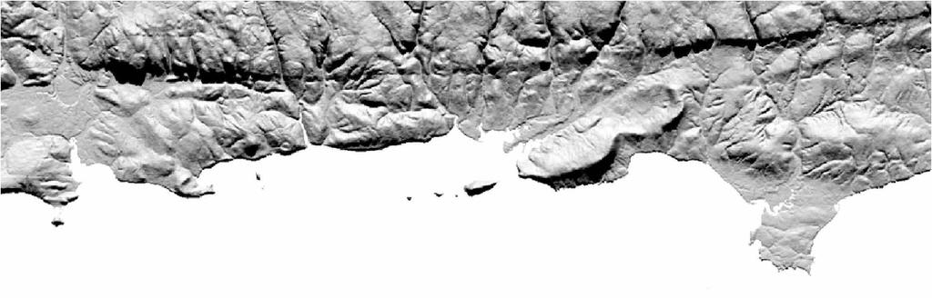
 Map of northern Fundy rift basin showing junction of three structural subbasins (Fundy, Minas, and Chignecto), geographic features, major faults, seismic coverage, and location of Cape Spencer")
 Geologic map of northern Fundy rift basin based on seismic, outcrop, and well data [Withjack et al., 1995; Wade et al.")
3 Figure 2. (a) Map of northern Fundy rift basin showing junction of three structural subbasins (Fundy, Minas, and Chignecto), geographic features, major faults, seismic coverage, and location of Cape Spencer well (P 79). Shaded relief map based on 1:50,000 digital elevation data from the Canadian Council on Geomatics (available at (b) Geologic map of northern Fundy rift basin based on seismic, outcrop, and well data [Withjack et al., 1995; Wade et al., 1996]; seafloor topography and subcrop information [Swift and Lyall, 1968]; and aeromagnetic data [King, 2005a, 2005b; Oneschuk and Dumont, 2005a, 2005b]. BI is Belleisle fault, and K is Kennebecasis fault of onshore New Brunswick. (c) Structure contour map of top of North Mountain Basalt. Contour interval is 0.1 s twoway travel time. rocks, which include siliciclastic strata, coals, carbonates, and evaporites [e.g., Waldron and Rygel, 2005]. The synrift section, based on the stratigraphic nomenclature of Olsen et al. [2000] and Olsen and Et Touhami [2008], consists of the following units from oldest to youngest: (1) the Honeycomb Point Formation, which is not well dated but possibly as old as Permian and composed predominantly of alluvial fan and eolian deposits; (2) the Middle to Upper Triassic Wolfville Formation, composed predominantly of fluvial deposits with minor eolian beds; (3) lacustrine, fluvial, and eolian rocks of 3of22
4 the Upper Triassic/Lower Jurassic Blomidon Formation; (4) the Lower Jurassic North Mountain Basalt, dated at 202 ± 2 Ma [Hodych and Dunning, 1992]; and (5) the Lower Jurassic fluviolacustrine McCoy Brook Formation, which also contains minor eolian and talus slope facies. [7] The Fundy rift basin has three major structural components: the Chignecto, Fundy, and Minas subbasins [Olsen and Schlische, 1990] (Figures 2a and 2b). The NE striking Chignecto and Fundy border fault zones bound the Chignecto and Fundy subbasins on the northwest, whereas the east striking Cobequid/Chedabucto border fault zone (also known as the Minas border fault zone) bounds the Fundy and Minas subbasins on the north. These border fault zones coincide with deep seated zones of weakness that developed during numerous Proterozoic and Paleozoic tectonic events that preceded rifting, including the late Paleozoic Alleghenian/Variscan orogeny [e.g., Plint and van de Poll, 1984; Olsen and Schlische, 1990; Withjack et al., 1995; Wade et al., 1996; Murphy et al., 1999]. Preexisting structures within the NE striking Chignecto and Fundy border fault zones include NE striking, SE dipping, lowangle Paleozoic thrust faults observed offshore [Withjack et al., 1995; Wade et al., 1996], and folds and NE striking, SE dipping thrust faults observed onshore in southern New Brunswick [e.g., Rast, 1983; Plint and van de Poll, 1984]. Steeply dipping, NE striking faults that had a significant strike slip component during Paleozoic deformation (e.g., the Belleisle and Kennebecasis faults) are also present onshore adjacent to the Chignecto and Fundy border fault systems (Figure 2b) [e.g., Rast, 1983; Currie, 1988; Murphy et al., 1999]. Preexisting structures within the east striking Cobequid/Chedabucto border fault zone include folds and numerous east to ENE striking, moderately to steeply dipping faults, many of which dip toward the south [e.g., Eisbacher, 1969; Keppie, 1982; Donohoe and Wallace, 1982; Rast, 1983; Mawer and White, 1987; Withjack et al., 1995; Wade et al., 1996; Macinnes and White, 2004]. These faults had a significant right lateral strike slip component during Paleozoic deformation. [8] NW SE extension resulted in the reactivation of many of these preexisting structures during Mesozoic rifting [Plint and van de Poll, 1984; Olsen and Schlische, 1990; Schlische and Ackermann, 1995; Schlische et al., 2002; Withjack et al., 2009]. Specifically, the reactivation of NE striking Paleozoic thrust faults produced low angle, SE dipping normal faults within the Chignecto and Fundy border fault zones. The reactivation of east striking Paleozoic strike slip faults produced high angle, south dipping, oblique slip faults with left lateral and normal components within the Cobequid/ Chedabucto border fault zone. Thus, many of the extensional faults within the border fault systems of the Fundy rift basin have anomalous dips, either gentle or steep, compared to those of newly formed normal faults. Also, the E W strike of many of the extensional faults within the Cobequid/Chedabucto border fault zone was oblique to the NW SE extension direction during rifting. 3. Seismic Reflection Data [9] More than 1200 km of seismic reflection profiles acquired by Chevron and Mobil from 1980 to 1982 cover the offshore portion of the study area (Figures 2a and 3) [Withjack et al., 1995]. A few key seismic profiles (e.g., Figures 4 and 5) were reprocessed in 1998, resulting in improved suppression of multiples and better imaging. Several seismic reflection profiles acquired by Consolidated Beacon Resources Ltd. in 2001 recently became publicly available (Figure 6). These profiles, which cover the onshore part of the study area in Nova Scotia, were instrumental in characterizing the geometry of the onshore Cobequid/ Chedabucto border fault zone at depth. Projections from onshore geology [Donohoe and Wallace, 1982; Withjack et al., 1995; Wade et al., 1996], offshore subcrops [Swift and Lyall, 1968], industry well data, and high resolution aeromagnetic data from the Fundy region [King, 2005a, 2005b; Oneschuk and Dumont, 2005a, 2005b] constrained our seismic interpretations (Figures 2 and 3). [10] Withjack et al. [1995] and Wade et al. [1996] recognized two main tectonostratigraphic packages in the offshore Fundy rift basin: a lower, prerift Precambrian and Paleozoic package; and an upper, synrift package of mostly Late Triassic to Early Jurassic age (Figures 3 7). Reflections in the prerift package are discontinuous and show considerable variability in dip direction. The synrift package is characterized by relatively continuous, subparallel reflections that (generally) dip and diverge toward their respective border faults, indicating that these faults were active during sedimentation from Middle Triassic to Early Jurassic time. Within the synrift package, the North Mountain Basalt creates a prominent group of closely spaced, high amplitude reflections, making its top surface relatively easy to map (e.g., Figure 4). An angular unconformity separates the prerift and synrift packages (e.g., Figure 7) Border Fault Zones of the Fundy Rift Basin [11] Our reinterpretation of the offshore seismic data, including the reprocessed lines, confirms the results of previous seismic studies by Withjack et al. [1995] and Wade Figure 3. Sections across the Fundy rift basin based on field, well, and seismic data (see Figure 2a for locations). A and S indicate anticlines and synclines discussed in text and shown in Figures 2b and 2c. Line drawings of seismic profiles are displayed at approximately 1:1 assuming an average velocity of 4.5 km/s. See discussion by Wade et al. [1996] for estimated seismic velocities for synrift, prerift, and basement rocks of the Fundy rift basin. Actual fault dips might be a few degrees gentler in the lower velocity sedimentary section and a few degrees steeper in the higher velocity prerift section and basement. (a) Seismic line 10 and offshore continuation. Contacts in center of basin are projected from Cape Blomidon (see Figure 2a for location). (b) Seismic line and onshore projection. (c) Northeastern portion of seismic line and onshore projection. (d) Seismic line and onshore projection. (e) Seismic line BF 51. (f) Seismic line and onshore projection. (g) Seismic line and onshore projection. (h) Seismic line of22

5 Figure 3 5of22
 exists in the hanging wall of one of the east striking faults within the Cobequid/Chedabucto border fault zone. Synrift strata thicken across the anticlinal crest toward the fault.")
![Thus, folding occurred after synrift deposition. Vertical exaggeration is 1:1 assuming a velocity 4.5 km/s. et al. [1996].](/docs-images/78/78456307/images/6-1.jpg "Namely, the Fundy and Chignecto border fault zones are NE striking and composed of numerous low angle faults that dip to the southeast (Figures 2 and 3).")
6 Figure 4. Part of line 81 47, (top) uninterpreted and (bottom) interpreted. The North Mountain Basalt produces a series of closely spaced, high amplitude reflections. An anticline (A3) exists in the hanging wall of one of the east striking faults within the Cobequid/Chedabucto border fault zone. Synrift strata thicken across the anticlinal crest toward the fault. Thus, folding occurred after synrift deposition. Vertical exaggeration is 1:1 assuming a velocity 4.5 km/s. et al. [1996]. Namely, the Fundy and Chignecto border fault zones are NE striking and composed of numerous low angle faults that dip to the southeast (Figures 2 and 3). The gently dipping fault surfaces create a series of high amplitude reflections that converge at midcrustal levels (Figure 3). The surface of the Chignecto fault, the easternmost fault of the Chignecto border fault zone, has several broad, SE plunging undulations that are well imaged on NE striking seismic lines (Figure 3e). The east striking Cobequid/Chedabucto borderfault zone is composed of a series of high angle faults whose dips progressively increase from west to east (Figure 3). The new onshore seismic data indicate that these high angle faults are relatively shallow features that merge with and/or overlie low angle, south dipping fault surfaces at depth (Figures 3 and 6). The low angle fault surfaces produce a series of high amplitude reflections similar to those associated with the Fundy and Chignecto border fault zones. The upward projection of the most prominent series of high amplitude reflections coincides with the surface location of the Cobequid fault (Figure 6) Postrift Deformation of the Fundy Rift Basin [12] The seismic data show that the postrift deformation in the northern Fundy subbasin and Minas subbasin has four, first order attributes (Figures 2b and 2c). [13] 1. Most major folds are subparallel to the adjacent border fault zone. Along the NE striking Fundy border fault zone, the major folds trend northeast, whereas along the east striking Cobequid/Chedabucto border fault zone, folds trend roughly east. The most prominent fold is a gentle, WSW plunging, basin scale syncline (S1) up to 50 km wide in the study area. The axial trace of this fold is subparallel to the Fundy and Cobequid/Chedabucto border fault zones, bending in concert with them. [14] 2. Folds are tighter along the east striking Cobequid/ Chedabucto border fault zone and along east striking segments of the Fundy border fault zone (Figure 2c). [15] 3. The arrangement of the hanging wall folds varies considerably between the Fundy and Cobequid/Chedabucto border fault zones. Commonly, an anticline is adjacent to the Fundy border fault zone (e.g., the western end of A3; 6of22

")


7 Figure 5. Part of line 82 28, (top) uninterpreted and (bottom) interpreted. A syncline (S3) is present in the hanging wall of one of the east striking faults within the Cobequid/Chedabucto border fault zone. Synrift strata thicken across the synclinal trough toward the fault. Thus, folding occurred after synrift deposition. Vertical exaggeration is 1:1 assuming a velocity 4.5 km/s. Multiples are better suppressed on the reprocessed NE end of the line. 7of22
.")
, whereas a train of folds is adjacent to the Cobequid/ Chedabucto border fault zone (e.g., S2, A3, S3, A4 in Figures 2 and 3).")
![[16] 4.](/docs-images/78/78456307/images/8-2.jpg "Synrift strata thicken toward the border fault zones across the anticlinal crests and the synclinal troughs, indicating that folding occurred postdepositionally as with all other inversion structures")
![here and throughout eastern North America [Withjack et al., 1995, 1998; Withjack and Schlische, 2005; Schlische et al., 2003].](/docs-images/78/78456307/images/8-3.jpg "[17] A prominent anticline/syncline pair is present within the Chignecto subbasin (A5/S4) (Figures 2b and 2c).")
8 Figure 6. Line drawing of seismic line 10 from onshore Nova Scotia, (top) uninterpreted and (bottom) interpreted. Seismic line is displayed approximately 1:1 assuming an average velocity of 4.5 km/s. Interpretation is based in part on work by Donohoe and Wallace [1982]. Contacts in center of basin are projected from Cape Blomidon (see Figure 2a for location). The faults within the Cobequid/Chedabucto border fault zone have gentle dips at depth, whereas the exposed fault splays have steep dips. Folds are present above the gently dipping segments of the Cobequid/Chedabucto border fault zone. Figure 4), whereas a train of folds is adjacent to the Cobequid/ Chedabucto border fault zone (e.g., S2, A3, S3, A4 in Figures 2 and 3). [16] 4. Synrift strata thicken toward the border fault zones across the anticlinal crests and the synclinal troughs, indicating that folding occurred postdepositionally as with all other inversion structures here and throughout eastern North America [Withjack et al., 1995, 1998; Withjack and Schlische, 2005; Schlische et al., 2003]. [17] A prominent anticline/syncline pair is present within the Chignecto subbasin (A5/S4) (Figures 2b and 2c). These folds plunge northwest and trend nearly perpendicular to the NE striking border fault zone, unlike the fault parallel folds in the Fundy and Minas subbasins. Anticline A5 occurs above a gentle structural high on the border fault surface (Figure 3e), is symmetric, and shows some subtle crestal thinning of synrift strata, indicating that folding occurred, at least partially, during synrift deposition [Withjack et al., 1995]. The fold is up to 10 km wide, and the amplitude of the fold decreases in magnitude away from the border fault zone. Syncline S4 is distinctly asymmetric, with the southwest limb dipping more steeply (>30 ) than the northeast limb (<10 ). This fold is at least 15 km wide. Its trough is concordant with a low on the border fault surface (Figure 3e), but 8of22


9 Figure 7. Part of seismic line BF 33, (top) uninterpreted and (bottom) interpreted, showing angular unconformity at synrift/prerift contact and Paleozoic thrust fault in the Chignecto subbasin. Vertical exaggeration is 1:1 assuming a velocity 4.5 km/s. the steep southwest limb does not parallel the fault surface. Synrift strata in syncline S4 thicken toward the southwest across the trough, indicating that the steepening of the southwest limb occurred postdepositionally. 4. Minas Subbasin Outcrop Data [18] The northern margin of the Minas subbasin contains cliff and tidal flat exposures that permit study of structures below the limits of seismic resolution. Withjack et al. [1995] first demonstrated that postrift shortening affected the eastern Minas subbasin, providing examples of faults with reverse separation, tight folds, and steeply dipping to overturned beds. They observed no growth strata associated with these structures, indicating that shortening occurred after the deposition of the Lower Jurassic McCoy Brook Formation, the youngest preserved synrift unit. In this section, we reexamine several of their field areas (locations in Figures 2a and 8) in greater detail, providing additional information about the geometry and kinematics of inversion structures in the Fundy rift basin. 9of22

10 Figure 8 10 of 22
11 4.1. Blue Sac [19] Blue Sac is located south of the ENE striking Portapique fault, one of the major faults within the Cobequid/ Chedabucto border fault zone, and on the northern limb of a major, NE trending syncline (Figures 8 and 9). All exposed strata at Blue Sac are part of the Lower Jurassic McCoy Brook Formation (Figure 9). Two facies are present: a basalt talus slope facies resulting from fault scarp erosion of the North Mountain Basalt and a coeval to younger fluvial lacustrine facies [Tanner and Hubert, 1991]. Withjack et al. [1995] described the main structure at Blue Sac as an east striking, south dipping fault (fault A) that crops out within the cliff face and exhibits reverse separation. They showed that the basalt talus slope deposits occur exclusively in its hanging wall, suggesting that the hanging wall was downthrown during deposition. [20] New exposures at Blue Sac have enabled additional mapping and data collection, yielding the following significant observations. [21] 1. Fault A has reverse separation, strikes due east, and dips 85 S (Figure 9). Slickenlines rake about 30 W, suggesting a significant component of strike slip movement during its final phase of activity. [22] 2. A minor, NW plunging syncline deforms the footwall strata. The fold is asymmetric, with the southwest limb dipping more steeply ( 60 NE) than the northeast limb ( 40 NW) (Figure 9a). Bedding shows increasing dips and counterclockwise rotation with increasing proximity to fault A. [23] 3. A minor, tight, SE plunging anticline deforms the hanging wall strata south of fault A. The northeast limb of this anticline is overturned (Figures 9b and 9c). [24] 4. Numerous minor, steeply dipping, east and ENE striking faults are present just south of fault A (Figures 9b and 9c). Slickenlines raking about 20 W, steps on slickensided surfaces, and left lateral offset of contacts indicate predominantly left lateral strike slip (with minor reverse slip) on these faults. [25] Structures at Blue Sac formed during and after rifting. Basalt talus slope deposits in the hanging wall of fault A suggest that this fault was active during synrift deposition [Tanner and Hubert, 1991; Withjack et al., 2009]. An absence of growth beds associated with the minor folding at Blue Sac suggests that the folds formed after synrift deposition. The minor faults at Blue Sac offset the folded beds. Thus, these faults developed after folding and, consequently, after synrift deposition. Fault A also offsets the folded beds, and the dips of the folded beds increase near fault A, suggesting that faulting influenced folding. Thus, fault A was active during and after folding and, consequently, after synrift deposition. In summary, fault A had two phases of activity: a synrift phase with unknown slip and a postrift phase with predominantly strike slip. If the minor NW trending folds at Blue Sac are secondary detachment (buckle) folds and if the slip on the minor faults at Blue Sac mirrors the slip on fault A, then fault A had predominantly left lateral strike slip (with minor reverse slip) after synrift deposition Wasson Bluff [26] An ENE plunging syncline between Wasson Bluff and Clarke Head (Figure 10a) forms the hook shaped ridge of North Mountain Basalt visible on the shaded relief map (Figure 8a). The syncline is bounded by ENE striking fault zones on both limbs. The largest faults within these fault zones juxtapose synrift strata with Carboniferous prerift strata. On the southern limb of the syncline near Clarke Head, a steep, ENE striking, SSE dipping fault with reverse separation (fault B) juxtaposes older, moderately dipping North Mountain Basalt over younger, steeply dipping and locally overturned McCoy Brook Formation (Figure 10b). The slip on fault B and most of the largest faults at Wasson Bluff is unknown. Numerous, minor east striking faults cut the folded synrift units at Wasson Bluff [Elder Brady, 2003]. One such fault (fault C; Figures 10a and 10b) has reverse separation, strikes due east, dips steeply to the north, and juxtaposes the North Mountain Basalt on the north with the McCoy Brook Formation (basalt talus slope facies and fluvial lacustrine facies) on the south. Beds in the North Mountain Basalt dip moderately to the south, whereas beds in the McCoy Brook Formation are steeply dipping to overturned (Figures 10a 10c). Slickenlines that rake 20 W and steps on the slickensided surface indicate that fault C had predominantly left lateral strike slip (with minor reverse slip) during its final phase of activity. [27] Structures at Wasson Bluff were active during and/or after rifting. Basalt talus slope deposits [Olsen et al., 1989; Tanner and Hubert, 1991] in the hanging wall of fault C indicate that it was active during synrift deposition [Withjack et al., 2009]. An absence of growth beds associated with folding indicates that folds formed after synrift deposition. Many of the faults, bounding and cutting the folded beds, were active during and/or after folding (i.e., after synrift deposition). Some faults (e.g., fault C) had two phases of activity: a synrift phase with unknown slip and a postrift phase with predominantly left lateral strike slip Five Islands Provincial Park [28] Recent field mapping indicates that considerable deformation in the Five Islands region occurred after rifting. Old Wife Point, composed predominantly of North Mountain Basalt, is bounded by very steeply dipping, NE striking faults (Figure 11). Numerous minor, steeply dipping, NE to NNE striking faults also cut the basalt within Old Wife Point. Exposed fault surfaces have predominantly subhorizontal slickenlines; some minor faults have subhorizontal Figure 8. (a) Shaded relief map of northern Minas subbasin based on shaded relief images from the Nova Scotia Department of Natural Resources (available at Location shown in Figure 2b. (b) Geologic map of northern Minas subbasin based on published geologic maps [Donohoe and Wallace, 1982; Olsen and Schlische, 1990; Schlische et al., 2003; Withjack et al., 2009] and high resolution aeromagnetic data [Oneschuk and Dumont, 2005a, 2005b]. Map shows location of three field sites (black boxes) and seismic line 10 (thick dashed line). 11 of 22


12 Figure 9. Geology of the Blue Sac area. (a) Simplified geologic map showing faults and distribution of facies in the McCoy Brook Formation. Bedding on north side of fault A steepens and rotates counterclockwise with increasing proximity to fault A. (b) Geologic cross section A A (location shown in Figure 9a), showing overturned anticline. (c) Detailed geologic map of boxed area in Figure 9a. Fault A strikes due east, dips steeply to the south, and has shallow SW raking slickenlines. Minor faults show left lateral separation and subhorizontal slickenlines. Anticline has overturned NE limb. (d) Photo of N S trending cliff face from pinnacle to north of fault A viewed toward the west; geologists for scale. 12 of 22
 Geologic cross section A A, showing fault bounded syncline. (c) Line drawing of exposures near fault C. Beds of the McCoy Brook Formation are steeply dipping to overturned southwest of fault C.")
![Modified from Olsen et al. [1989]. slickenlines overprinting dip slip slickenlines. Steps on slickensided surfaces indicate left lateral strike slip.](/docs-images/78/78456307/images/13-1.jpg "At the map scale, faults also exhibit left lateral separation (Figure 11a).")
 (cf. Stevens [1987], who has interpreted Old Wife Point as a dike).")
13 Figure 10. Geology of Wasson Bluff. (a) Simplified geologic map showing faults, distribution of formations, and location of cross section A A. (b) Geologic cross section A A, showing fault bounded syncline. (c) Line drawing of exposures near fault C. Beds of the McCoy Brook Formation are steeply dipping to overturned southwest of fault C. Modified from Olsen et al. [1989]. slickenlines overprinting dip slip slickenlines. Steps on slickensided surfaces indicate left lateral strike slip. At the map scale, faults also exhibit left lateral separation (Figure 11a). Bedding in the Blomidon and McCoy Brook formations and layering within the North Mountain Basalt (perpendicular to the cooling columns) steepen markedly toward the faults bounding Old Wife Point and become subvertical within the fault zone (Figure 11c) (cf. Stevens [1987], who has interpreted Old Wife Point as a dike). These monoclines have NE trending hinge lines, affect all exposed synrift units (i.e., the Blomidon to McCoy Brook formations), and lack growth beds. Thus, the NE trending folds and the NE striking, left lateral strike slip faults that bound and cut them developed after synrift deposition. [29] The NE striking faults of the Old Wife fault zone appear to link the major, east striking faults in the Five Islands region (Figures 8 and 11a). Many onshore faults (e.g., the Gerrish Mountain fault) are evident on the shaded relief map (Figure 8a). The inferred offshore faults bound the island chain on the south and north and merge in the west. Within this context, the Old Wife fault zone transfers displacement from the offshore faults to the onshore Gerrish Mountain fault. The offshore faults continue westward and ultimately link with the major east striking faults imaged seismically (Figure 2). This pattern of longer east striking faults linked by shorter NE striking faults is present along much of the Cobequid Chedabucto fault system [Olsen and Schlische, 1990] and is a fault pattern produced in experimental (analog) models of oblique extension (in this case, NW SE) acting on a preexisting fault system (in this case, the east striking Cobequid Chedabucto fault zone) [Schlische et al., 2002]. 5. Discussion 5.1. Seismic Data [30] The seismic data show that most major faults within the NE and east striking border fault zones have gentle dips. Many faults within the east striking border fault zone, however, have steep dips at shallow levels. As discussed previously, all of these faults with their anomalously gentle or steep dips (compared to those of newly formed normal faults) are likely reactivated preexisting structures that developed during the orogenic events that preceded rifting [e.g., Plint 13 of 22
 Geologic cross section. (c) Photograph of Old Wife Point bounded by fault D and fault E. Thick white lines highlight cooling columns in basalt; dashed lines are subparallel to cooling surfaces.")
14 Figure 11. Geology of Five Islands Provincial Park. (a) Simplified geologic map showing faults, distribution of formations, and location of geologic cross section shown in Figure 11b. (b) Geologic cross section. (c) Photograph of Old Wife Point bounded by fault D and fault E. Thick white lines highlight cooling columns in basalt; dashed lines are subparallel to cooling surfaces. Geologist for scale. and van de Poll, 1984; Olsen and Schlische, 1990; Withjack et al., 1995; Wade et al., 1996]. The seismic data also show that the NE and east striking border fault zones are linked along strike and at depth, forming the composite border fault system of the Fundy rift basin. [31] The seismic data show that folding occurred after rifting. The folds fall into two categories: (1) folds that are subparallel to the adjacent border fault zone and (2) folds that trend more or less orthogonally to the adjacent border fault zone. We propose that the fault parallel folds are, at least partially, buttress folds. Buttress folds commonly form in the hanging walls of normal faults during basin inversion [e.g., Dart et al., 1995; McClay, 1995; Baum et al., 2008]. Slip occurs more easily along the lower, more gently dipping fault segments; however, the upper, more steeply dipping fault segments act as a buttress, thereby inhibiting slip and causing 14 of 22
15 beneath the steep southern limb of S4 is not affected by this folding, indicating that a detachment level exists between the base of the synrift section and the surface of the borderfault zone. Considering the limited distance between the base of the synrift section and the surface of the border fault zone (Figure 3e), the most likely detachment level is the borderfault zone itself. Based on these observations, we believe that S4 is primarily a detachment fold that formed after rifting. Figure 12. Obliquity of inversion in map view. The angle between the trend of the rift border fault zone and the direction of the horizontal component of displacement of its hanging wall relative to its footwall is a s. Orthogonal inversion occurs when a s = 90, and oblique inversion occurs when 90 < a s < 0. the hanging wall strata to shorten and fold. Most geologic examples of buttress folds consist of a single hanging wall anticline whose axis parallels the adjacent fault [e.g., Dart et al., 1995]. A train of fault parallel folds (e.g., S2, A3, S3, A4 in Figure 2), however, exists within the hanging wall of the Cobequid/Chedabucto border fault zone (Figures 2b and 2c). The onshore seismic data show that these folds do not affect the gently dipping, lower segment of the borderfault zone (Figure 6), indicating that a detachment level exists between the folded synrift section and the border fault zone. Potential detachment levels include evaporitic units within the prerift section [e.g., Waldron and Rygel, 2005] and the Cobequid/Chedabucto border fault zone itself. Thus, many of the fault parallel folds in the hanging wall of the Cobequid/ Chedabucto border fault zone are likely a combination of buttress and detachment folds that formed during the reactivation of the border fault zone during basin inversion. [32] The fault perpendicular folds in the Chignecto subbasin developed during and after rifting (Figures 2b and 2c). Subtle crestal thinning of the synrift strata suggests that A5 developed, at least partially, during the deposition of the synrift strata. Similar folds exist in other rift basins and result from along strike variations in fault displacement during rifting [Wheeler, 1939; Schlische, 1995; Withjack et al., 2002]. Not all fault perpendicular folding in the Chignecto subbasin, however, occurred during rifting. Synrift strata consistently thicken toward the southwest across syncline S4, showing that its steep southern limb formed after synrift deposition (Figure 3e). The surface of the border fault zone 5.2. Field Sites [33] The three field sites provide information about the smaller scale postrift deformation within the east striking Cobequid/Chedabucto border fault zone of the Minas subbasin. [34] 1. At Blue Sac, the postrift deformation consists of an east striking, steeply dipping fault with predominantly strike slip and numerous, east to ENE striking, steeply dipping minor faults with predominantly left lateral strike slip (and minor reverse slip). Minor, NW trending folds also developed at Blue Sac before and/or during the strike slip faulting. [35] 2. At Wasson Bluff, the postrift deformation consists of east to ENE striking faults, some of which had predominantly left lateral strike slip (with minor reverse slip). The axial trace of the syncline at Wasson Bluff parallels these faults (i.e., it has an east to ENE trending axial trace) and developed before and/or during strike slip faulting. [36] 3. Postrift deformation at Old Wife Point consists of numerous NE striking, steeply dipping, left lateral strike slip faults. NE trending folds parallel these faults and developed before and/or during the strike slip faulting. [37] The magnitude and sense of slip on the larger east striking faults within the Cobequid/Chedabucto border fault zone during inversion is unknown. However, their sense of slip is likely similar to that on the east striking faults observed at the field sites (i.e., predominantly left lateral strike slip with minor reverse slip). We note that their map view separation may differ significantly from their actual slip. For example, the offset of the North Mountain Basalt in the Five Islands region indicates that the Gerrish Mountain fault has about 2 km of right lateral separation (Figure 8). Although 2 km of right lateral strike slip could produce this separation, it is equally possible (considering the gentle dip of the basalt) that combined left lateral strike slip and reverse slip (approximately 2 km and 1 km, respectively) could produce the observed separation Inversion of the Fundy Rift Basin [38] What do these observed deformation patterns imply about the kinematics of inversion in the Fundy rift basin? We define a s as the angle between the trend of a border fault zone and the direction of the horizontal component of displacement of its hanging wall relative to its footwall during shortening (Figure 12). Orthogonal inversion occurs if a s = 90, oblique inversion occurs if 0 < a s < 90, and strike slip deformation occurs if a s = 0. The composite border fault system of the Fundy rift basin has two trends (NE and east) (Figure 2). Thus, a regionally consistent displacement direction of the hanging wall of the composite border fault system 15 of 22
16 relative to its footwall would produce different inversion styles on the differently oriented border fault zones. [39] The axial traces of fault related folds (i.e., fault bend folds, fault propagation folds, and buttress folds) reflect the geometry of the adjacent faults, not the regional shortening direction [e.g., Apotria, 1995; Tindall and Davis, 1999; Yamada and McClay, 2004]. Thus, the presence of a buttress fold in the hanging wall of a fault simply implies that a component of the displacement was toward the fault during inversion. Therefore, the presence of buttress folds in the hanging wall of the NE striking Fundy border fault zone suggests that the direction of the horizontal component of displacement during inversion could range from northeast to southwest (Figure 13a, range of possible displacement directions i). The presence of buttress folds in the hanging wall of the east striking Chignecto/Chedabucto border fault zone suggests that the direction of the horizontal component of displacement during inversion could range from east to west (Figure 13a, range of possible displacement directions ii). Finally, the presence of east to ENE striking, left lateral strike slip faults (with minor reverse slip) within the east striking Chignecto/Chedabucto border fault zone suggests that the direction of the horizontal component of displacement during inversion could range from east to north (Figure 13a, range of possible displacement directions iii). Together, these data indicate that the hanging wall of the composite border fault system of the Fundy rift basin moved approximately north northeast relative to the footwall during inversion (Figure 13a, range of possible displacement directions iv). [40] With this NNE displacement direction, the east striking Cobequid/Chedabucto border fault zone had oblique slip (with reverse and left lateral components) and underwent moderately oblique inversion (a s > 45 ) (Figures 13b, 13c, and 14b). In response, fault parallel buttress and combination buttress/detachment folds and left lateral strike slip faults developed at shallow levels above the border fault zone (Figure 14a, line 10, and Figure 14b). The NE striking Fundy border fault zone had oblique slip (minor reverse and major left lateral components) and underwent highly oblique inversion (a s < 30 ) (Figures 13b, 13c, and 14b). In response, fault parallel buttress folds developed in the hanging wall of the Fundy border fault zone (Figure 14a, line 81 79, and Figure 14b). Generally, the buttress folding associated with the Fundy border fault zone is gentle (e.g., anticline A in the southwest corner of Figure 2c), reflecting the relatively minor reverse component of slip and the relatively planar geometry of the faults within the NE striking border fault zones. However, folding is tighter (i.e., anticline A1) at a rightstepping bend (Figures 2c and 14a, line 81 79). This is likely a restraining bend associated with NNE directed displacement of the hanging wall relative to the footwall. Faultperpendicular detachment folding occurred in the hanging wall of the NE striking Chignecto border fault zone, likely reflecting the northeast transport of its hanging wall over its irregular footwall (Figure 14a, line BF 51). It is unclear whether any of the steeply dipping, NE striking faults exposed onshore adjacent to the Fundy and Chignecto border fault zones (e.g., the Belleisle and Kennebecasis faults) (Figure 2b) were reactivated during inversion. Several authors [e.g., West et al., 1993; Doll et al., 1996; West and Roden Tice, 2003] have suggested that the Norumbega fault, a similar NE striking, steeply dipping fault in eastern Maine, was active during the Mesozoic after rifting had ceased in eastern North America. [41] Deformation in the Fundy rift basin, particularly along the east striking Cobequid/Chedabucto border fault zone, closely resembles the updip partitioning associated with the Clarence fault of New Zealand, a normal fault subsequently reactivated during oblique plate convergence [Nicol and Van Dissen, 2002]. As discussed by Nicol and Van Dissen [2002], the Clarence fault is an oblique slip fault with reverse and strike slip components at depth where it is gently dipping. Deformation is partitioned on its updip, more steeply dipping segment into strike slip on the Clarence fault itself and hanging wall uplift associated with distributed shortening (see Figure 9 of Nicol and Van Dissen [2002]) Comparison With Experimental (Analog) Models [42] As discussed previously, experimental (analog) modeling studies have shown that obliquity affects the types of structures that develop during basin inversion [Brun and Nalpas, 1996; Dubois et al., 2002; Amilibia et al., 2005]. In all of these modeling studies, planar normal faults dipping 60 formed during the initial extensional phase. Comparisons of the results from modeling studies with observations from the Fundy rift basin indicate that the geometries of the rift related faults, in addition to obliquity, profoundly affect the deformation produced during basin inversion (Figure 15). For example, the models of Brun and Nalpas [1996] show that if obliquity is relatively low (i.e., 90 > a s > 45 ), as it is for the Cobequid/Chedabucto border fault zone, then new thrust faults are likely to form during basin inversion, and the preexisting normal faults, if reactivated, have primarily strike slip (Figure 15a). For the Cobequid/Chedabucto border fault Figure 13. (a) Possible directions of horizontal component of displacement of hanging wall relative to footwall of composite border fault system of Fundy rift basin during inversion. Range of possible displacement directions i is based on presence of buttress folds in hanging wall of NE striking Fundy border fault zone. Range of possible displacement directions ii is based on presence of buttress/detachment folds in hanging wall of east striking Cobequid/Chedabucto border fault zone. Range of possible displacement directions iii is based on presence of east and NE striking, left lateral strike slip faults observed at field sites. Range of possible displacement directions iv is based on the combined information. (b) Regional and (c) local maps of northern Fundy rift basin. Large, hollow arrows show horizontal component of displacement direction of hanging wall relative to footwall of composite border fault system during inversion. The NE striking border fault zones underwent highly oblique inversion (a s < 30 ), whereas the east striking border fault zone underwent moderately oblique inversion (a s > 45 ). See text for discussion. 16 of 22


17 Figure of 22
 Schematic block diagram showing contrasting styles of inversion related deformation in the hanging wall of the composite border fault system of the Fundy")
 results of experimental (analog) models from Brun and Nalpas [1996] and (b) results of this study of")
18 Figure 14. (a) Simplified cross sections through Fundy rift basin showing slip during inversion. Locations given in Figure 13b. (b) Schematic block diagram showing contrasting styles of inversion related deformation in the hanging wall of the composite border fault system of the Fundy rift basin. BFZ is border fault zone. See text for discussion. Figure 15. Comparison of inversion related deformation based on (a) results of experimental (analog) models from Brun and Nalpas [1996] and (b) results of this study of the inverted Fundy rift basin. All map views are oriented so that the faults are parallel to the edge of the chart. 18 of 22
19 Figure of 22
20 zone, however, few new thrust faults formed during inversion (Figure 15b). Instead, the border fault zone, gently dipping at depth, was reactivated as an oblique slip fault with reverse and strike slip components. Partitioning occurred only at shallow levels. Fault parallel buttress folds and combination buttress/detachment folds formed in the hanging wall of the Cobequid/Chedabucto border fault zone, accommodating the reverse slip component at shallow levels. Steeply dipping segments of the border fault zone at shallow depth were reactivated as left lateral strike slip faults, accommodating the strike slip component. Thus, the presence of extensional faults with anomalously gentle and steep dips profoundly affected the type and distribution of the inversion related deformation. 6. Summary and Conclusions [43] We have defined the 3 D geometries of the extensional and inversion structures in the Mesozoic Fundy rift basin using seismic, field, aeromagnetic, and DEM data. Our work shows that the geometry of the extensional faults, as well as obliquity, profoundly affects the style of deformation produced during inversion. The type of inversion related faults, the type and shape of inversion related folds, and the distribution of this deformation depend on the geometry of the preexisting extensional faults and the variations of these geometries with depth and along strike. [44] 1. The composite border fault system of the Fundy rift basin is complex, consisting of linked NE and east striking border fault zones. All faults within the border fault zones have gentle dips at depth. The east striking border fault zone, however, consists of faults with very steep dips at shallow levels. Thus, many of the extensional faults within the composite border fault system of the Fundy rift basin have anomalous dips, either gentle or steep, compared to those of newly formed normal faults. These anomalous dips reflect the preexisting fault fabric created during orogenic activity before rifting. [45] 2. The Fundy rift basin underwent oblique, not orthogonal, inversion (i.e., the displacement direction during shortening was oblique to the border fault zones). Specifically, the hanging wall block of the composite border fault system moved NNE relative to the footwall block during inversion. In response, the NE striking border fault zones underwent highly oblique inversion (a s < 30 ), whereas the east striking border fault zone underwent moderately oblique inversion (a s > 45 ). [46] 3. During inversion, all border fault zones were reactivated with oblique slip at depth. The inversion related deformation at shallow levels varied, however, reflecting differences in the preexisting fault fabric and the obliquity of inversion. Gentle fault parallel buttress folds, faultperpendicular detachment folds related to fault surface undulations, and folds related to restraining bends formed in the hanging walls of the NE striking border fault zones where obliquity was high. Relatively tight, fault parallel buttress or combination buttress/detachment folds formed in the hanging wall of the east striking border fault zone where obliquity was low to moderate. Additionally, the east striking, steeply dipping fault segments were reactivated as left lateral strike slip faults. Deformation associated with the east striking border fault zone closely resembles the updip partitioning associated with the Clarence fault of New Zealand, a normal fault subsequently reactivated during oblique plate convergence [Nicol and Van Dissen, 2002]. [47] 4. The inversion related deformation in the Fundy rift basin differs significantly from that observed in experimental (analog) models of oblique inversion, particularly those with low to moderate obliquity in which normal faults (dipping 60 ) show limited reactivation and new thrust/reverse faults develop to accommodate the shortening. Our work indicates that low angle extensional faults, if present, are likely to be reactivated as oblique slip faults at depth during inversion, regardless of obliquity, negating the need for the formation of new deep seated thrust faults. Furthermore, the presence of low angle extensional faults at depth and high angle extensional faults at shallow levels is likely to promote updip partitioning of the inversion related deformation. [48] Acknowledgments. We thank Consolidated Beacon Resources for early access to the onshore seismic data, the Nova Scotia Petroleum Board for access to the onshore and offshore data, and Sam Ting (formerly of Mobil Corporation) for reprocessing some key seismic reflection profiles. We also thank David Brown, Jennifer Elder Brady, Michael Durcanin, Paul Olsen, and Iain Sinclair for valuable, thought provoking discussions. Grants from the Petroleum Research Fund of the American Chemical Society and the National Science Foundation partially supported this research. Finally, we thank the donors of the Steve Fox Fund, which partially supported the Rutgers Field Geology class, whose participants (especially Michael Durcanin, Amber Granger, Alissa Henza, Emily Poorvin, Pasquale Robustini, Douglas Oliver, Stephen Kearsey, and Paul Whipp) visited the field sites discussed here. References Amilibia, A., K. R. McClay, F. Sabat, J. A. Munoz, and E. Roca (2005), Analogue modeling of inverted oblique rift systems, Geol. Acta, 3, Apotria, T. G. (1995), Thrust sheet rotation and out ofplane strains associated with oblique ramps: An example from the Wyoming salient, U.S.A., J. Struct. Geol., 17, , doi: / (94)00087-g. Baum, M. S., M. O. Withjack, and R. W. Schlische (2008), The ins and outs of buttress folds: Examples from the Fundy rift basin, Nova Scotia and New Brunswick, Canada, in Central Atlantic Conjugate Margins, Program and Extended Abstracts, edited by D. E. Brown, pp , Dalhousie Univ., Halifax, N. S., Canada. Benson, R. N. (2003), Age estimates of the seawarddipping volcanic wedge, earliest oceanic crust, and earliest drift stage sediments along the North American Atlantic continental margin, in The Central Atlantic Magmatic Province: Insights From Fragments of Pangea, Geophys. Monogr. Ser., vol. 146, edited by W. Hames et al., pp , AGU, Washington, D. C. Brun, J. P., and T. Nalpas (1996), Graben inversion in nature and experiments, Tectonics, 15, , doi: /95tc Buchanan, J. G., and P. G. Buchanan (Eds.) (1995), Basin Inversion, Geol. Soc. Spec. Publ., 88, 596 pp. Buchanan, P. G., and K. R. McClay (1991), Sandbox experiments of inverted listric and planar fault systems, Tectonophysics, 188, , doi: / (91)90317-L. Cooper, M. A., and G. D. Williams (Eds.) (1989), Inversion Tectonics, Geol. Soc. Spec. Publ., 44, 382 pp. Coward, M. (1994), Inversion tectonics, in Continental Deformation, editedbyp.l.hancock,pp , Pergamon, New York. Coward, M. P. (1996), Balancing sections through inverted basins, in Modern Developments in Struc- 20 of 22
Influence of pre-existing fault fabric on inversion-related deformation: A case study of the inverted Fundy rift basin, southeastern Canada
 Reprinted from: TECTONICS, VOL. 29, TC6004, doi:10.1029/2010tc002744, 2010 Influence of pre-existing fault fabric on inversion-related deformation: A case study of the inverted Fundy rift basin, southeastern
Central Atlantic Conjugate Margins Conference Halifax
 Central tlantic Conjugate Margins Conference Halifax 8 Reprinted from Conjugate Margins Conference, Halifax, 8 The Ins and Outs of uttress Folds: Examples from the Inverted Fundy Rift asin, ova cotia and
Extensional development of the Fundy rift basin, southeastern Canada
 GEOLOGICAL JOURNAL Geol. J. 44: 631 651 (2009) Published online 30 October 2009 in Wiley InterScience (www.interscience.wiley.com).1186 Extensional development of the Fundy rift basin, southeastern Canada
Extensional development of the Fundy rift basin, southeastern Canada
 Published in Geological Journal, v. 44, 631-651 (2009), DOI: 10.1002/gj.1186 Extensional development of the Fundy rift basin, southeastern Canada MARTHA O. WITHJACK 1*, ROY W. SCHLISCHE 1, and MARK S.
Name. GEOL.5220 Structural Geology Faults, Folds, Outcrop Patterns and Geologic Maps. I. Properties of Earth Materials
 I. Properties of Earth Materials GEOL.5220 Structural Geology Faults, Folds, Outcrop Patterns and Geologic Maps Name When rocks are subjected to differential stress the resulting build-up in strain can
Study the architecture and processes responsible for deformation of Earth s crust. Folding and Faulting
 Crustal Deformation AKA Structural geology (adapted from Brunkel, 2012) Study the architecture and processes responsible for deformation of Earth s crust. Folding and Faulting How Rocks Deform: 4 Controls
Geologic Structures. Changes in the shape and/or orientation of rocks in response to applied stress
 Geologic Structures Changes in the shape and/or orientation of rocks in response to applied stress Figure 15.19 Can be as big as a breadbox Or much bigger than a breadbox Three basic types Fractures >>>
Chapter 15 Structures
 Chapter 15 Structures Plummer/McGeary/Carlson (c) The McGraw-Hill Companies, Inc. TECTONIC FORCES AT WORK Stress & Strain Stress Strain Compressive stress Shortening strain Tensional stress stretching
The chapters in part I provide new and valuable
 PART I TECTONICS AND STRUCTURE OF SUPERCONTINENT BREAKUP 2 Introduction Martha Oliver Withjack and Roy W. Schlische The chapters in part I provide new and valuable information about the tectonic and structural
Strike-Slip Faults. ! Fault motion is parallel to the strike of the fault.
 Strike-Slip Faults! Fault motion is parallel to the strike of the fault.! Usually vertical, no hanging-wall/footwall blocks.! Classified by the relative sense of motion. " Right lateral opposite block
Stress and Strain. Stress is a force per unit area. Strain is a change in size or shape in response to stress
 Geologic Structures Geologic structures are dynamically-produced patterns or arrangements of rock or sediment that result from, and give information about, forces within the Earth Produced as rocks change
Structural Style and Tectonic Evolution of the Nakhon Basin, Gulf of Thailand
 Structural Style and Tectonic Evolution of the Nakhon Basin, Gulf of Thailand Piyaphong Chenrai Petroleum Geoscience Program, Department of Geology, Faculty of Science, Chulalongkorn University, Bangkok
What Causes Rock to Deform?
 Crustal Deformation Earth, Chapter 10 Chapter 10 Crustal Deformation What Causes Rock to Deform? Deformation is a general term that refers to all changes in the shape or position of a rock body in response
CRUSTAL DEFORMATION. Chapter 10
 CRUSTAL DEFORMATION and dgeologic Structures t Chapter 10 Deformation Df Deformation involves: Stress the amount of force applied to a given area. Types of Stress: Confining Stress stress applied equally
Description of faults
 GLG310 Structural Geology Description of faults Horizontal stretch Crustal thickness Regional elevation Regional character Issues Normal Thrust/reverse Strike-slip >1 1 in one direction and < 1 in
Tectonics is a study of the major structural features of the Earth s crust or a broad structure of a region. Tecto- means building
 TECTONICS AND TECTONIC STRUCTURES Tectonics is a study of the major structural features of the Earth s crust or a broad structure of a region. Tecto- means building The plate theory Different stages are
Part I. PRELAB SECTION To be completed before labs starts:
 Student Name: Physical Geology 101 Laboratory #13 Structural Geology II Drawing and Analyzing Folds and Faults Grade: Introduction & Purpose: Structural geology is the study of how geologic rock units
Crustal Deformation Earth - Chapter Pearson Education, Inc.
 Crustal Deformation Earth - Chapter 10 Structural Geology Structural geologists study the architecture and processes responsible for deformation of Earth s crust. A working knowledge of rock structures
How mountains are made. We will talk about valleys (erosion and weathering later)
") How mountains are made We will talk about valleys (erosion and weathering later) http://www.ilike2learn.com/ilike2learn/mountainmaps/mountainranges.html Continent-continent plate convergence Less dense,
How mountains are made We will talk about valleys (erosion and weathering later) http://www.ilike2learn.com/ilike2learn/mountainmaps/mountainranges.html Continent-continent plate convergence Less dense,
Answers: Internal Processes and Structures (Isostasy)
") Answers: Internal Processes and Structures (Isostasy) 1. Analyse the adjustment of the crust to changes in loads associated with volcanism, mountain building, erosion, and glaciation by using the concept
Answers: Internal Processes and Structures (Isostasy) 1. Analyse the adjustment of the crust to changes in loads associated with volcanism, mountain building, erosion, and glaciation by using the concept
How to Build a Mountain and other Geologic Structures. But first a short review
 How to Build a Mountain and other Geologic Structures But first a short review Where do we see deep earthquakes? What is happening there? What can happen at a plate boundary? 1. Plates can move apart
Crustal Deformation. (Building Earth s Surface, Part 1) Science 330 Summer Mapping geologic structures
 Science 330 Summer Mapping geologic structures") Crustal Deformation (Building Earth s Surface, Part 1) Science 330 Summer 2005 Mapping geologic structures When conducting a study of a region, a geologist identifies and describes the dominant rock structures
Crustal Deformation (Building Earth s Surface, Part 1) Science 330 Summer 2005 Mapping geologic structures When conducting a study of a region, a geologist identifies and describes the dominant rock structures
Structural Geology Lab. The Objectives are to gain experience
 Geology 2 Structural Geology Lab The Objectives are to gain experience 1. Drawing cross sections from information given on geologic maps. 2. Recognizing folds and naming their parts on stereoscopic air
Lecture 6 Folds, Faults and Deformation Dr. Shwan Omar
 Fold: A fold is a bend or wrinkle of rock layers or foliation; folds form as a sequence of ductile deformation. Folding is the processes by which crustal forces deform an area of crust so that layers of
KEY CHAPTER 12 TAKE-HOME QUIZ INTERNAL STRUCTURES AND PROCESSES Score Part B = / 55 PART B
 GEOLOGY 12 KEY CHAPTER 12 TAKE-HOME QUIZ INTERNAL STRUCTURES AND PROCESSES Score Part B = / 55 PART B CHAPTER 12 Isostacy and Structural Geology 1. Using the terms below, label the following diagrams and
Orphan Basin, Offshore Newfoundland: New seismic data and hydrocarbon plays for a dormant Frontier Basin
 Orphan Basin, Offshore Newfoundland: New seismic data and hydrocarbon plays for a dormant Frontier Basin Jerry Smee* G&G Exploration Consulting, 301 400-3rd Avenue SW, Calgary, AB, T2P 4H2 Sam Nader, Paul
Structural Style in the Peel Region, NWT and Yukon
 Structural Style in the Peel Region, NWT and Yukon Adriana Taborda* Husky Energy and University of Calgary, Calgary, AB Adriana.Taborda@huskyenergy.ca and Deborah Spratt University of Calgary, Calgary,
Structural Modelling of Inversion Structures: A case study on South Cambay Basin
 10 th Biennial International Conference & Exposition P 065 Structural Modelling of Inversion Structures: A case study on South Cambay Basin Dr. Mayadhar Sahoo & S.K Chakrabarti Summary The inversion in
Continental Landscapes
 Continental Landscapes Landscape influenced by tectonics, climate & differential weathering Most landforms developed within the last 2 million years System moves toward an equilibrium Continental Landscapes
Structural Styles and Geotectonic Elements in Northwestern Mississippi: Interpreted from Gravity, Magnetic, and Proprietary 2D Seismic Data
 Structural Styles and Geotectonic Elements in Northwestern Mississippi: Interpreted from Gravity, Magnetic, and Proprietary 2D Seismic Data Nick Loundagin 1 and Gary L. Kinsland 2 1 6573 W. Euclid Pl.,
Earth Science, (Tarbuck/Lutgens) Chapter 10: Mountain Building
 Chapter 10: Mountain Building") Earth Science, (Tarbuck/Lutgens) Chapter 10: Mountain Building 1) A(n) fault has little or no vertical movements of the two blocks. A) stick slip B) oblique slip C) strike slip D) dip slip 2) In a(n) fault,
Earth Science, (Tarbuck/Lutgens) Chapter 10: Mountain Building 1) A(n) fault has little or no vertical movements of the two blocks. A) stick slip B) oblique slip C) strike slip D) dip slip 2) In a(n) fault,
Deformation of Rocks. Orientation of Deformed Rocks
 Deformation of Rocks Folds and faults are geologic structures caused by deformation. Structural geology is the study of the deformation of rocks and its effects. Fig. 7.1 Orientation of Deformed Rocks
Structural Geology of the Mountains
 Structural Geology of the Mountains Clinton R. Tippett Shell Canada Limited, Calgary, Alberta clinton.tippett@shell.ca INTRODUCTION The Southern Rocky Mountains of Canada (Figure 1) are made up of several
Lab 7: STRUCTURAL GEOLOGY FOLDS AND FAULTS
 Lab 7: STRUCTURAL GEOLOGY FOLDS AND FAULTS This set of labs will focus on the structures that result from deformation in earth s crust, namely folds and faults. By the end of these labs you should be able
GEOLOGIC MAPS PART II
 EARTH AND ENVIRONMENT THROUGH TIME LABORATORY - EES 1005 LABORATORY FIVE GEOLOGIC MAPS PART II Introduction Geologic maps of orogenic belts are much more complex than maps of the stable interior. Just
Lecture # 6. Geological Structures
 1 Lecture # 6 Geological Structures ( Folds, Faults and Joints) Instructor: Dr. Attaullah Shah Department of Civil Engineering Swedish College of Engineering and Technology-Wah Cantt. 2 The wavy undulations
GEOL 321 Structural Geology and Tectonics
 GEOL 321 Structural Geology and Tectonics Geology 321 Structure and Tectonics will be given in Spring 2017. The course provides a general coverage of the structures produced by brittle and ductile rock
Estimating inversion: results from clay models
 Estimating inversion: results from clay models G L O R I A E I S E N S T A D T & M A R T H A O L I V E R W I T H J A C K Mobil Research and Development Corporation, PO Box 650232, Dallas, T X 75265, USA
Section 3 Deforming Earth s Crust
 Section 3 Deforming Earth s Crust Key Concept Tectonic plate motions deform Earth s crust. Deformation causes rock layers to bend and break and causes mountains to form. What You Will Learn Stress is placed
In this lab, we will study and analyze geologic maps from a few regions, including the Grand Canyon, western Wyoming, and coastal California.
 Name: Lab Section: work in groups, but each person turns in his/her own GEOSCIENCE 001 LAB UNDERSTANDING GEOLOGIC MAPS Geologic maps are colorful and even beautiful, but they also contain an amazing amount
LAB 1: ORIENTATION OF LINES AND PLANES
 LAB 1: ORIENTATION OF LINES AND PLANES Read the introductory section, chapter 1, pages 1-3, of the manual by Rowland et al (2007) and make sure you understand the concepts of bearing, strike, dip, trend,
Geological Mapping at Parrsboro (Cape Sharp to McKay Head), Nova Scotia
, Nova Scotia") Report of Activities 2014 1 Geological Mapping at Parrsboro (Cape Sharp to McKay Head), Nova Scotia J. H. Calder, R. D. Naylor, J. W. F. Waldron 1, K. Adams 2, T. Fedak 2, E. George 3, P. S. Giles 4 and
Report of Activities 2014 1 Geological Mapping at Parrsboro (Cape Sharp to McKay Head), Nova Scotia J. H. Calder, R. D. Naylor, J. W. F. Waldron 1, K. Adams 2, T. Fedak 2, E. George 3, P. S. Giles 4 and
Course Title: Discipline: Geology Level: Basic-Intermediate Duration: 5 Days Instructor: Prof. Charles Kluth. About the course: Audience: Agenda:
 Course Title: Structural Geology Discipline: Geology Level: Basic-Intermediate Duration: 5 Days Instructor: Prof. Charles Kluth About the course: This course covers the basic ideas of structural geometry
Team Name. Name(s) SSSS Unome Geologic Mapping Test Packet p1
 SSSS Unome Geologic Mapping Test Packet p1") Scioly Summer Study Session 2018-2019 Geologic Mapping Test Packet Written by Unome Instructions 1) This test is based on the 2016 rules for Geologic Mapping. 2) This test is out of 115 points. Questions
Scioly Summer Study Session 2018-2019 Geologic Mapping Test Packet Written by Unome Instructions 1) This test is based on the 2016 rules for Geologic Mapping. 2) This test is out of 115 points. Questions
UNIT 10 MOUNTAIN BUILDING AND EVOLUTION OF CONTINENTS
 UNIT 10 MOUNTAIN BUILDING AND EVOLUTION OF CONTINENTS ROCK DEFORMATION Tectonic forces exert different types of stress on rocks in different geologic environments. STRESS The first, called confining stress
Plate Tectonics. entirely rock both and rock
 Plate Tectonics I. Tectonics A. Tectonic Forces are forces generated from within Earth causing rock to become. B. 1. The study of the origin and arrangement of Earth surface including mountain belts, continents,
1. classic definition = study of deformed rocks in the upper crust
 Structural Geology I. Introduction 1. classic definition = study of deformed rocks in the upper crust deformed includes translation, rotation, and strain (change of shape) All rocks are deformed in some
3.3. Tectonics of Rifting and Drifting: Pangea Breakup
 N.B., FOR BEST RESULTS, PRINT AT 85% Previous Next 3.3. Tectonics of Rifting and Drifting: Pangea Breakup 3.3.2. Extracting Tectonic Information from Cores in Rift Basins Roy W. Schlische Department of
Geomorphology Final Exam Study Guide
 Geomorphology Final Exam Study Guide Geologic Structures STRUCTURAL GEOLOGY concerned with shapes, arrangement, interrelationships of bedrock units & endogenic (within) forces that cause them. Tectonic
UNDERSTANDING GEOLOGIC M APS
 Name: Lab Section: work in groups, but each person turns in his/her own GEOSCIENCE 001 L AB UNDERSTANDING GEOLOGIC M APS Geologic maps are colorful and even beautiful, but they also contain an amazing
Structural Geology Lab. The Objectives are to gain experience
 Geology 2 Structural Geology Lab The Objectives are to gain experience 1. Drawing cross sections from information given on geologic maps. 2. Recognizing folds and naming their parts on stereoscopic air
How to Build a Mountain and other Geologic Structures. But first, questions
 How to Build a Mountain and other Geologic Structures But first, questions Questions your students might ask How were Montana s mountains formed? How old are the mountains? What are the different ways
Summary. Study Area. Data Acquisition
 Evidence for hyper-extended continental crust in the East Orphan Basin from seismic reflection data and potential field forward modelling and inversion J. Kim Welford 1, Deric Cameron 2, James Carter 2
Seismic stratigraphy, some examples from Indian Ocean, interpretation of reflection data in interactive mode
 Seismic stratigraphy, some examples from Indian Ocean, interpretation of reflection data in interactive mode K. S. Krishna National Institute of Oceanography, Dona Paula, Goa-403 004. krishna@nio.org Seismic
Copyright McGraw-Hill Education. All rights reserved. No reproduction or distribution without the prior written consent of McGraw-Hill Education
 Copyright McGraw-Hill Education. All rights reserved. No reproduction or distribution without the prior written consent of McGraw-Hill Education Tibetan Plateau and Himalaya -southern Asia 11.00.a VE 10X
You must take the exam in the lecture section for which you are registered. Any exceptions must be cleared with the instructor in advance.
 Geo 101, Fall 2000 Review Questions for Final Exam GEOLOGIC TIME AND FOLDING AND FAULTING THE FINAL EXAM FOR MWF CLASS WILL BE TUESDAY 1400 THE FINAL EXAM FOR TR CLASS WILL BE FRIDAY 930 These questions
Answer sheet for question 1 Answer question 1 as soon as the sample arrives at your desk.
 EAS 233 Geologic structures. Final test. April 2012. 3 hours. Answer question 1 and 2 and three other questions. If you start more than the required number of questions, clearly delete the answers you
11.1 Rock Deformation
 Tarbuck Lutgens Mountain Building 11.1 Rock Deformation Factors Affecting Deformation Factors that influence the strength of a rock and how it will deform include temperature, confining pressure, rock
Folds and Folding. Processes in Structural Geology & Tectonics. Ben van der Pluijm. WW Norton+Authors, unless noted otherwise 3/4/ :15
 Folds and Folding Processes in Structural Geology & Tectonics Ben van der Pluijm WW Norton+Authors, unless noted otherwise 3/4/2017 17:15 We Discuss Folds and Folding Fold Description Fold Classification
Chapter 16. Mountain Building. Mountain Building. Mountains and Plate Tectonics. what s the connection?
 Chapter 16 Mountains and Plate Tectonics what s the connection? Mountain Building Most crustal deformation occurs along plate margins. S.2 Active Margin Passive Margin Mountain Building Factors Affecting
A comparison of structural styles and prospectivity along the Atlantic margin from Senegal to Benin. Peter Conn*, Ian Deighton* & Dario Chisari*
 A comparison of structural styles and prospectivity along the Atlantic margin from Senegal to Benin Overview Peter Conn*, Ian Deighton* & Dario Chisari* * TGS, Millbank House, Surbiton, UK, KT6 6AP The
Lecture 9. Folds and Folding. Earth Structure (2 nd Edition), 2004 W.W. Norton & Co, New York Slide show by Ben van der Pluijm
, 2004 W.W. Norton & Co, New York Slide show by Ben van der Pluijm") Lecture 9 Folds and Folding Earth Structure (2 nd Edition), 2004 W.W. Norton & Co, New York Slide show by Ben van der Pluijm WW Norton; unless noted otherwise Fold Classification Maryland Appalachians
Lecture 9 Folds and Folding Earth Structure (2 nd Edition), 2004 W.W. Norton & Co, New York Slide show by Ben van der Pluijm WW Norton; unless noted otherwise Fold Classification Maryland Appalachians
Deepwater Niger Delta fold-and-thrust belt modeled as a critical-taper wedge: The influence of a weak detachment on styles of fault-related folds
 Deepwater Niger Delta fold-and-thrust belt modeled as a critical-taper wedge: The influence of a weak detachment on styles of fault-related folds Frank Bilotti 1, Chris Guzofski 1, John H. Shaw 2 1 Chevron
Convergent plate boundary.
 Crustal Deformation Convergent plate boundary http://my.execpc.com/~acmelasr/mountains/geogramsnf.html Plate Tectonic Settings and Magma Where plates CONVERGE, water is driven off the subducting plate,
MUHAMMAD S TAMANNAI, DOUGLAS WINSTONE, IAN DEIGHTON & PETER CONN, TGS Nopec Geological Products and Services, London, United Kingdom
 Geological and Geophysical Evaluation of Offshore Morondava Frontier Basin based on Satellite Gravity, Well and regional 2D Seismic Data Interpretation MUHAMMAD S TAMANNAI, DOUGLAS WINSTONE, IAN DEIGHTON
Lab 6: Plate tectonics, structural geology and geologic maps
 Geology 103 Name(s): Lab 6: Plate tectonics, structural geology and geologic maps Objective: To show the effects of plate tectonics on a large-scale set of rocks and to reconstruct the geological history
Lecture Outlines PowerPoint. Chapter 10 Earth Science, 12e Tarbuck/Lutgens
 Lecture Outlines PowerPoint Chapter 10 Earth Science, 12e Tarbuck/Lutgens 2009 Pearson Prentice Hall This work is protected by United States copyright laws and is provided solely for the use of instructors
Diachronous Rifting, Drifting, and Inversion on the Passive Margin of Central Eastern North America: An Analog for Other Passive Margins 1
 Diachronous Rifting, Drifting, and Inversion on the Passive Margin of Central Eastern North America: An Analog for Other Passive Margins 1 Martha Oliver Withjack, 2 Roy W. Schlische, 3 and Paul E. Olsen
8.0 SUMMARY AND CONCLUSIONS
 8.0 SUMMARY AND CONCLUSIONS In November 2008, Pacific Gas and Electric (PG&E) informed the U.S. Nuclear Regulatory Commission (NRC) that preliminary results from the Diablo Canyon Power Plant (DCPP) Long
Structure of the western Brooks Range fold and thrust belt, Arctic Alaska
 Trabajos de Geología, Universidad de Oviedo, 29 : 218-222 (2009) Structure of the western Brooks Range fold and thrust belt, Arctic Alaska J. DE VERA 1* AND K. MCCLAY 2 1Now at: Shell, Rijswijk, Netherlands.
surface uplift of fault-related folds rely primarily on their limbs and associated
 Finite and Quaternary shortening calculation Finite shortening Models commonly used to constrain the structural evolution, shortening, and surface uplift of fault-related folds rely primarily on their
Section 10.1 The Nature of Volcanic Eruptions This section discusses volcanic eruptions, types of volcanoes, and other volcanic landforms.
 Chapter 10 Section 10.1 The Nature of Volcanic Eruptions This section discusses volcanic eruptions, types of volcanoes, and other volcanic landforms. Reading Strategy Previewing Before you read the section,
Relative Timing of CAMP, Rifting, Continental Breakup, and Basin Inversion: Tectonic Significance
 Relative Timing of CAMP, Rifting, Continental Breakup, and Basin Inversion: Tectonic Significance Roy W. Schlische and Martha Oliver Withjack Department of Geological Sciences, Rutgers University, Piscataway,
Blocks Module Content Guide
 Blocks Module Content Guide This guide covers the basics of the content within the Interactive 3D Geologic Blocks Module. The content guide is intended to assist you, the teacher, in creating effective
Essentials of Geology, 11e
 Essentials of Geology, 11e Crustal Deformation and Mountain Building Chapter 17 Instructor Jennifer Barson Spokane Falls Community College Geology 101 Stanley Hatfield Southwestern Illinois College Jennifer
Chapter. Mountain Building
 Chapter Mountain Building 11.1 Rock Deformation Factors Affecting Deformation Factors that influence the strength of a rock and how it will deform include temperature, confining pressure, rock type, and
Chapter 10: Deformation and Mountain Building. Fig. 10.1
 Chapter 10: Deformation and Mountain Building Fig. 10.1 OBJECTIVES Describe the processes of rock deformation and compare and contrast ductile and brittle behavior in rocks. Explain how strike and dip
Before Plate Tectonics: Theory of Continental Drift
 Before Plate Tectonics: Theory of Continental Drift Predecessor to modern plate tectonics Shape and fit of the continents was the initial evidence Snider-Pelligrini (1858) Taylor (1908) Wegner (1915) Fig.
Earthquakes. Earthquakes are caused by a sudden release of energy
 Earthquakes Earthquakes are caused by a sudden release of energy The amount of energy released determines the magnitude of the earthquake Seismic waves carry the energy away from its origin Fig. 18.1 Origin
Dip-Sequence Analysis
 Chapter 9 Dip-Sequence Analysis 9.1 Introduction The three-dimensional geometry of a structure can be determined from the bedding attitudes measured in a single well bore or on a traverse through a structure.
APPENDIX C GEOLOGICAL CHANCE OF SUCCESS RYDER SCOTT COMPANY PETROLEUM CONSULTANTS
 APPENDIX C GEOLOGICAL CHANCE OF SUCCESS Page 2 The Geological Chance of Success is intended to evaluate the probability that a functioning petroleum system is in place for each prospective reservoir. The
Lecture Outline Friday March 2 thru Wednesday March 7, 2018
 Lecture Outline Friday March 2 thru Wednesday March 7, 2018 Questions? Lecture Exam Friday March 9, 2018 Same time, Same room Bring Pencils and WSU ID 50 question Multiple Choice, Computer Graded Interlude
Staple this part to part one of lab 6 and turn in. Lab 6, part two: Structural geology (analysis)
") Geology 101 Staple this part to part one of lab 6 and turn in Lab 6, part two: Structural geology (analysis) Recall that the objective of this lab is to describe the geologic structures of Cougar Mountain
Geology 101 Staple this part to part one of lab 6 and turn in Lab 6, part two: Structural geology (analysis) Recall that the objective of this lab is to describe the geologic structures of Cougar Mountain
(1) Identify 5 major principles of relative dating? For each principle, describe how you tell what is younger and what is older.
 Identify 5 major principles of relative dating? For each principle, describe how you tell what is younger and what is older.") Things to Know - Third GLG101Exam Page 1 Important Note: This is not everything you need to know or study. However, it provides you with a relatively comprehensive list of questions to help you study.
Things to Know - Third GLG101Exam Page 1 Important Note: This is not everything you need to know or study. However, it provides you with a relatively comprehensive list of questions to help you study.
!'f \, w. Alan Stewart Colorado Exploration Company, Golden STRUCTURE OF THE FOOTHILLS AREA WEST OF DENVER, COLORADO. Introduction
 STRUCTURE OF THE FOOTHLLS AREA WEST OF DENVER, COLORADO w. Alan Stewart Colorado Exploration Company, Golden ntroduction i ; The dominant structural features west of Denver and along the mountain front
RELINQUISHMENT REPORT. License P1546 Block April 2009
 RELINQUISHMENT REPORT License P1546 Block 110-01 14 April 2009 Sherritt International Oil and Gas Limited 2000, 425-1 st street S.W., Calgary, Alberta Canada T2P 3L8 Telephone (403) 260-2900 Fax (403)
3. The diagram below shows how scientists think some of Earth's continents were joined together in the geologic past.
 1. The map below shows the present-day locations of South America and Africa. Remains of Mesosaurus, an extinct freshwater reptile, have been found in similarly aged bedrock formed from lake sediments
USU 1360 TECTONICS / PROCESSES
 USU 1360 TECTONICS / PROCESSES Observe the world map and each enlargement Pacific Northwest Tibet South America Japan 03.00.a1 South Atlantic Arabian Peninsula Observe features near the Pacific Northwest
Chapter 3. Geology & Tectonics
 Chapter 3 Geology & Tectonics 3.1 Geology The general geological features of Indonesia are shown in Figure 3.1. The basement formation is metamorphic and it is intruded with plutonic formations. They are
Geologic Mapping Invitational Trial Event
 Geologic Mapping Invitational Trial Event A TEAM OF UP TO: 2 Team Name AVAILABLE TIME: 50 min Required Materials: Each team MUST have a protractor, ruler, non-programmable calculator, colored pencils,
Lecture 15. Fold-Thrust Belts, and the NJ Ridge and Valley Thrust System
 Lecture 15 Fold-Thrust Belts, and the NJ Ridge and Valley Thrust System Earth Structure (2 nd Edition), 2004 W.W. Norton & Co, New York Slide show by Ben van der Pluijm WW Norton; unless noted otherwise
Distortion Effects of Faults on Gravity Worm Strings Robin O Leary
 Distortion Effects of Faults on Gravity Worm Strings Robin O Leary Problem Can upward continued gravity anomaly worm strings be used as a tool to determine the dip direction of an offsetting structure
Mountains are then built by deforming crust: Deformation & Mountain Building. Mountains form where stresses are high!
 Deformation & Mountain Building Where are mountains located? Deformation and Folding Mountain building Mountains form where stresses are high! Mountains form at all three types of plate boundaries where
Salt tectonic styles in the spreading basin: Yucatan, Offshore Mexico Purnima Bhowmik*, Rodolfo Hernandez and Katarina Rothe, TGS
 1 Purnima Bhowmik*, Rodolfo Hernandez and Katarina Rothe, TGS Summary The TGS Gigante project is comprised of 188,497 km of 2D seismic data acquired in 2016 and primarily covering the offshore Mexican
GEOLOGY MEDIA SUITE Chapter 13
 UNDERSTANDING EARTH, SIXTH EDITION GROTZINGER JORDAN GEOLOGY MEDIA SUITE Chapter 13 Earthquakes 2010 W.H. Freeman and Company Three different types of seismic waves are recorded by seismographs Key Figure
Mountains and Mountain Building: Chapter 11
 Mountains and Mountain Building: Chapter 11 Objectives: 1)Explain how some of Earth s major mountain belts formed 2) Compare and contrast active and passive continental margins 3) Explain how compression,
L.K. Carr 1, R.J. Korsch 1, A.J. Mory 2, R.M. Hocking 2, S.K. Marshall 1, R.D. Costelloe 1, J. Holzschuh 1, J.L. Maher 1. Australia.
 STRUCTURAL AND STRATIGRAPHIC ARCHITECTURE OF WESTERN AUSTRALIA S FRONTIER ONSHORE SEDIMENTARY BASINS: THE WESTERN OFFICER AND SOUTHERN CARNARVON BASINS L.K. Carr 1, R.J. Korsch 1, A.J. Mory 2, R.M. Hocking
IV OTHER TYPES OF BASINS
 IV OTHER TYPES OF BASINS 1-Strike-slip basins 2-Cratonic basins 3 Late orogenic basins and more 1 Tectonic setting of strike-slip faulting Woodcock 1986 2 Seismic examples of stike-slip faults «!Flower
A) B) C) D) 4. Which diagram below best represents the pattern of magnetic orientation in the seafloor on the west (left) side of the ocean ridge?
 B) C) D) 4. Which diagram below best represents the pattern of magnetic orientation in the seafloor on the west (left) side of the ocean ridge?") 1. Crustal formation, which may cause the widening of an ocean, is most likely occurring at the boundary between the A) African Plate and the Eurasian Plate B) Pacific Plate and the Philippine Plate C)
1. Crustal formation, which may cause the widening of an ocean, is most likely occurring at the boundary between the A) African Plate and the Eurasian Plate B) Pacific Plate and the Philippine Plate C)
New Mexico Geological Society
 New Mexico Geological Society Downloaded from: http://nmgs.nmt.edu/publications/guidebooks/27 Structural framework of the southern Raton Basin, New Mexico Lee A. Woodward and D. O. Snyder, 1976, pp. 125-127