Great earthquakes and new insights into subduction seismogenesis
|
|
|
- Clarence Ward
- 6 years ago
- Views:
Transcription


1 Great earthquakes and new insights into subduction seismogenesis Heather R. DeShon Southern Methodist University GeoPRISMS DLP Georgia Southwestern State University Feb. 27th, 2013
2 The earth, the very emblem of solidity, has moved beneath our feet like a thick crust over a fluid. - Charles Darwin reflecting on experiencing the Feb great Concepción, Chile earthquake The Voyage of the Beagle, 1845

3 Zandt, 2002 Outline! Subduction megathrust faults and the seismogenic zone! Subduction cycles and deformation! Outstanding questions! Great earthquakes! Recent insights! Future concerns! New models


4 The Active Earth


5 Plates - rigid lithosphere riding on a convecting mantle

6 3 Types of Plate Boundaries Divergent Transform Convergent

7 Global distribution of convergent boundaries Convergent boundaries


8 End Member Models of Subduction Zones megathrust

9 Subduction is part of the mantle convection system Subduction and arc volcanism are great water recyclers Subduction and arc processes help build continental crust Stern, 2002


10 Subduction megathrust faults generate great earthquakes & tsunami 2011 Japan tsunami 1960 Chile tsunami 1964 Alaska tsunami 2010 Maule, Chile earthquake Hilo, Hawaii damage 2004 M 9.2 Sumatra 1960 Chile earthquake

11 The megathrust and tsunamis
 over a finite")
 by M O")
12 Rupture dimensions and displacement During an earthquake, slip spreads out from the initiation point (hypocenter) over a finite distance. Seismologists calculate seismic moment (a measure of energy) by M O = A * D *µ Moment = fault area * average displacement * rigidity
13 Subduction zones generate the largest earthquakes because megathrusts are long, dipping structures with big fault areas Magnitude Effects largest recorded eathquakes destruction over vast area massive loss of life great earthquake severe economic impact large loss of life major earthquake damage ($ billions) loss of life strong earthquake property damage moderate earthquake some property damage Earthquakes Chile (1960) Alaska (1964) Sumatra (2004) Japan (2011) Chile (2010) San Francisco, CA (1906) New Madrid, MO (1812) Charleston, SC (1886) Haiti (2010) Northridge (1994) Long Island, NY (1884) < ,500 Energy Equivalents Krakatoa Eruption Worldʼs Largest Nuclear Test (USSR) Mount St. Helens Eruption Hiroshima Atomic Bomb Average Tornado Energy Release (equivalent kilograms of TNT) 15,000,000,000, ,000,000,000 15,000,000, ,000,000 15,000, , light earthquake noticeable shaking minor earthquake often felt generally not felt 10, ,000 1,000,000 Large Lightning Bolt Oklahoma City Bombing Moderate Lightning Bolt 15, Number of Earthquakes per year (worldwide)

14 Great earthquakes M W!8 Source: USGS
15 Magnitude does NOT scale with fatalities Source: USGS
, and")

16 NSF GeoPRISMS Program GeoPRISMS investigates the coupled geodynamics, earth surface processes, and climate interactions that build and modify continental margins over a wide range of timescales (from s to My), and cross the shoreline, with applications to margin evolution & dynamics, construction of stratigraphic architecture, accumulation of economic resources, and associated geologic hazards and environmental management.


17 ! Two broadly integrated initiatives Subduction Cycles & Deformation Rift Initiation & Evolution! Research at Primary Sites & through Thematic Studies
18 A Relevant SCD Key Question What governs the size, location and frequency of great subduction zone earthquakes and how is this related to the spatial and temporal variation of slip behaviors observed along subduction faults? log[characteristic duration (s)] B year 1 month 1 day c M w 1 hour Gap a VLF b Slow earthquakes Silent EQ ETS SSE d Regular earthquakes e 1 LFE log[seismic moment (N m)] Ide et al. 2007
19
20 Unzipping the Sunda subduction zone

21 Focal Mechanisms Seismologists represent motion along a fault using lower hemisphere projections beachballs Reverse faults, like subduction megathrust faults, have the colored quadrant centered in the circle

22 Unzipping the Sunda subduction zone


23 Backprojection Models: Watching slip happen seconds Moment rate function Ishii et al., 2005 Alex Hutco

24 The 2004 tsunami! >250,000 fatalities! Run-up heights >4 m Banda Aceh! Tsunami last longer than earthquake shaking


25 2004 M W 9.2 megathrust earthquake, 2007 M W 8.4 megathrust earthquake & 2010 M W 7.8 tsunami earthquake

26 2005 M W 8.7 Nias earthquake & Afterslip Hsu et al., 2006


27 Largest intraplate earthquakes ever recorded! 2012-Magnitude 8.6 and 8.2 OFF W COAST NORTHERN SUMATRA Gut reaction: These intraplate earthquakes were caused by strike-slip faulting within Indian Plate oceanic lithosphere. N S oriented fracture zones project into the area of the earthquakes and are the likely faults offset during these events. Ninetyeast Ridge M 8.6 M 8.2 Investigator Ridge

28 Aftershocks and backprojection results soon tell a different story

29 2010 M W 8.8 Maule, Chile earthquake

30 ab 1943 M = S 32 SS 32 án Nazca plate M = M Santiago Santiago 32 S Fig Santiago 34 SS 34 Aftershock location er Ju a n F d n án 32 S ez r i dge 85% 75% 33 S Nazca Fig. 2 plate 1 34 S m yr 66 m 34 S m yr Volcano 38 SS S South America plate 1960 Sliver M = motion WW 38 S Crustal faulting Crustal faulting 40 S Arauco peninsula LiquiñeOfqui fault zone 40 S WW Longitude WW 75 W 42 S WW WW WW 38 S 39 S GPS station km km 42 SS S South America plate GPS station Sliver motion km km WW SS S 10 m 5m 1m 36 S 1m e Peru t re nch 38 S Postseismic relaxation Concepción 10 m 5m Concepción Arauco peninsula 36 SS m 15 m Postseismic relaxation Concepción nc 36 S tre 1835 M 8.5 and 2010 M = h 35 S Ch ile Per u Latitude 66 m bearly Latitude ern Ju a n F r i dge NATURE Vol September 2010 Fraction of plate convergence a M = z de 30 S 30 mm yr 1 Fraction of plate convergence 30 mm yr 1 34 S c bc 30 SS S Chil o Interseismic plate coupling predictive value? LETTERS LETTERS NATURE Vol September WW Longitude the 2010Methods). Maule earthquake 1 Tectonic the2010 study area,earthquake data, observations and see online-only Maule (for references ata,figure observations and setting ofthe 74 W 73 W 72 W Longitude 40 S 71 W km 5 N p Figure 3 Relationship between pre, co- and postseismic 75 W 73 W 71 W 69 slip distribution during thew2010 ( patterns. a, Coseismic USGS slip model26) and 1960 (green contours; from ref. 3 overlain onto pre-seismic locking pattern (red shading $0 early (during the first 48 h post-shock) M $ 5 aftershock lo (for references see online-only Methods). circle sizes scale with magnitude; GEOFON data29). b, His Moreno et al., 2010

31 2011 M W 9.0 Tohoku-oki, Japan, earthquake

32 Slip in the 2010 Chile and 2011 Japan events Maximum slip is ~50 m in the Japan earthquake! via backprojection Lay et al., 2012

33 Part of houses swallowed by tsunami burn in Sendai, Miyagi Prefecture (state) after Japan was struck by a strong earthquake off its northeastern coast Friday, March 11, New York Times The tsunami waves traveled far inland, the wave of debris racing across the farmland, carrying boats and houses with it.

34 The Future: Cascadia


35 History of earthquakes: the turbidite record A. Full or nearly full rupture, 19 events B. Mid-Southern rupture, 3-4 events. C. Rupture from central Oregon southward, events. D. S Oregon/N California events, minimum of 7-8 events. Chris Goldfinger, OR State
*'!+(%!,--.(/!")
36 Tremor recurrence varies along Cascadia!!!!!!!!!!!!!!!! "#$%&'()*'!+(%!,--.(/!0112!!


37 Tremor lies downdip of the seismogenic zone Hyndman et al., 1995; Wech and Creager, 2011

38 Summary Each new earthquake brings further insight into the seismogenic zone Fault complexity may be related to variable frictional stability conditions along the fault Fault behavior may vary from seismic cycle to seismic cycle Lay et al., 2012


39 Acknowledgements!! NSF GeoPRISMS and Margins program Collaborators: Susan Bilek, Susan Schwartz, Cliff Thurber, Bob Engdahl, Jeremy Pesicek, Haijiang Zhang, Sri Widiyantaro, Wolfgang Rabbel, Melissa Driskell, Shishay Bisrat 6 subduction megathrust earthquakes over the last 106 years account for over half of the energy released during that time.
Oklahoma Earthquakes: Trends and Underlying Causes. Jeremy Boak, Oklahoma Geological Survey October 21, 2016
 Oklahoma Earthquakes: Trends and Underlying Causes Jeremy Boak, Oklahoma Geological Survey jboak@ou.edu October 21, 2016 1 The Oklahoma Geological Survey is a state agency for research and public service
Tsunami waves swept away houses and cars in northern Japan and pushed ships aground.
 Japan was struck by a magnitude 8.9 earthquake off its northeastern coast Friday. This is one of the largest earthquakes that Japan has ever experienced. In downtown Tokyo, large buildings shook violently
Plotting Earthquake Epicenters*
 Plotting Earthquake Epicenters* Seismic discovery Note: This is not an activity from the CEETEP workshop, but is a good prerequisite to the triangulation activity that follows. x In this activity, students
Sendai Earthquake NE Japan March 11, Some explanatory slides Bob Stern, Dave Scholl, others updated March
 Sendai Earthquake NE Japan March 11, 2011 Some explanatory slides Bob Stern, Dave Scholl, others updated March 14 2011 Earth has 11 large plates and many more smaller ones. Plates are 100-200 km thick
Magnitude 7.5 PALU, INDONESIA
 A magnitude 7.5 earthquake occurred 80.8 km (50.2 mi) north of Palu, Indonesia at a depth of 10 km (6.2 miles). This earthquake triggered a tsunami with wave heights up to 2 m (6.6 ft) that an official
Dynamic Earth A B1. Which type of plate boundary is located at the Jordan Fault? (1) divergent (3) convergent (2) subduction (4) transform
 divergent (3) convergent (2) subduction (4) transform") Dynamic Earth A B1 1. The edges of most lithospheric plates are characterized by (1) reversed magnetic orientation (2) unusually rapid radioactive decay (3) frequent volcanic activity (4) low P-wave and
Dynamic Earth A B1 1. The edges of most lithospheric plates are characterized by (1) reversed magnetic orientation (2) unusually rapid radioactive decay (3) frequent volcanic activity (4) low P-wave and
Magnitude 7.1 NEAR THE EAST COAST OF HONSHU, JAPAN
 Japan was rattled by a strong aftershock and tsunami warning Thursday night nearly a month after a devastating earthquake and tsunami flattened the northeastern coast. This earthquake can be considered
The Mega-Earthquakes of Chile: Seismology and the Sounds of the Earth
 The Mega-Earthquakes of Chile: Seismology and the Sounds of the Earth Michael Wysession Department of Earth and Planetary Sciences Washington University, St. Louis, MO Puerto Montt, Chile, November 6,
Deformation cycles of great subduction earthquakes in a viscoelastic Earth
 Deformation cycles of great subduction earthquakes in a viscoelastic Earth Kelin Wang Pacific Geoscience Centre, Geological Survey of Canada School of Earth and Ocean Science, University of Victoria????
Chapter 15. Earthquakes and Plate Tectonics. what s the connection? At the boundaries friction causes plates to stick together.
 Chapter 15 Earthquakes and Plate Tectonics what s the connection? As with volcanoes, earthquakes are not randomly distributed over the globe At the boundaries friction causes plates to stick together.
Three Fs of earthquakes: forces, faults, and friction. Slow accumulation and rapid release of elastic energy.
 Earthquake Machine Stick-slip: Elastic Rebound Theory Jerky motions on faults produce EQs Three Fs of earthquakes: forces, faults, and friction. Slow accumulation and rapid release of elastic energy. Three
Magnitude 7.0 N of ANCHORAGE, ALASKA
 A magnitude 7.0 earthquake occurred just before 8:30 am local time 8 miles north of Anchorage at a depth of 40.9 km (25.4 miles). There are reports of major infrastructure damage and damage to many homes
Magnitude 7.9 SE of KODIAK, ALASKA
 A magnitude 7.9 earthquake occurred at 12:31 am local time 181 miles southeast of Kodiak at a depth of 25 km (15.5 miles). There are no immediate reports of damage or fatalities. Light shaking from this
Magnitude 7.1 PERU. There are early reports of homes and roads collapsed leaving one dead and several dozen injured.
 A magnitude 7.1 earthquake has occurred offshore Peru. The earthquake struck just after 4 a.m. local time and was centered near the coast of Peru, 40 km (25 miles) south-southwest of Acari, Peru at a depth
Dynamic Crust Practice
 1. Base your answer to the following question on the cross section below and on your knowledge of Earth science. The cross section represents the distance and age of ocean-floor bedrock found on both sides
A GLOBAL SURGE OF GREAT EARTHQUAKES FROM AND IMPLICATIONS FOR CASCADIA. Thorne Lay, University of California Santa Cruz
 A GLOBAL SURGE OF GREAT EARTHQUAKES FROM 2004-2014 AND IMPLICATIONS FOR CASCADIA Thorne Lay, University of California Santa Cruz Last 10 yrs - 18 great earthquakes: rate 1.8/yr; rate over preceding century
Earthquake Hazards. Tsunami
 Earthquake Hazards Tsunami Review: What is an earthquake? Earthquake is the vibration (shaking) and/or displacement of the ground produced by the sudden release of energy. The point inside the Earth where
Earthquake Hazards. Tsunami
 Earthquake Hazards Tsunami Measuring Earthquakes Two measurements that describe the power or strength of an earthquake are: Intensity a measure of the degree of earthquake shaking at a given locale based
Magnitude 7.0 PERU. This region of the Andes is a sparsely populated area, there were no immediate reports of injuries or damage.
 A magnitude 7.0 earthquake occurred in southeastern Peru on Friday about 27 kilometers northeast of the town of Azángaro, Peru, near the border with Bolivia. The earthquake occurred at a depth of 257.4
Study megathrust creep to understand megathrust earthquakes
 1 Study megathrust creep to understand megathrust earthquakes Kelin Wang Pacific Geoscience Centre, Geological Survey of Canada, kelin.wang@canada.ca Introduction Once upon a time, there was a belief that
Internal Layers of the Earth
 Lecture #4 notes Geology 3950, Spring 2006; CR Stern Seismic waves, earthquake magnitudes and location, and internal earth structure (pages 28-95 in the 4 th edition and 28-32 and 50-106 in the 5 th edition)
What is an Earthquake?
 Earthquakes What is an Earthquake? Earthquake - sometimes violent shaking of ground caused by movement of Earth s tectonic plates; creates seismic waves Often followed by smaller earthquakes (aftershocks);
MAR110 Lecture #5 Plate Tectonics-Earthquakes
 1 MAR110 Lecture #5 Plate Tectonics-Earthquakes Figure 5.0 Plate Formation & Subduction Destruction The formation of the ocean crust from magma that is upwelled into a pair of spreading centers. Pairs
Magnitude 7.2 OAXACA, MEXICO
 A magnitude 7.2 earthquake has occurred in Oaxaca, Mexico at a depth of 24.6 km (15 miles). It was felt as far away as Guatemala. There have been no reported deaths directly linked to the earthquake. Emergency
Earthquake Hazards. Tsunami
 Earthquake Hazards Tsunami Review: What is an earthquake? Earthquake is the vibration (shaking) and/or displacement of the ground produced by the sudden release of energy. The point inside the Earth where
Magnitude 6.5 OFFSHORE NORTHERN CALIFORNIA
 A powerful offshore earthquake that struck near the Northern California coast left a hodgepodge of debris for communities to sort through Sunday but spared residents any serious injury. After 25,000 people
Lab 1: Plate Tectonics April 2, 2009
 Name: Lab 1: Plate Tectonics April 2, 2009 Objective: Students will be introduced to the theory of plate tectonics and different styles of plate margins and interactions. Introduction The planet can be
Magnitude 8.2 NORTHWEST OF IQUIQUE, CHILE
 An 8.2-magnitude earthquake struck off the coast of northern Chile, generating a local tsunami. The USGS reported the earthquake was centered 95 km (59 miles) northwest of Iquique at a depth of 20.1km
Learning Objectives (LO)! Lecture 11: Plate Tectonics II! No Homework!! ** Chapter 3 **! What we ll learn today:!
! Lecture 11: Plate Tectonics II! No Homework!! ** Chapter 3 **! What we ll learn today:!") Learning Objectives (LO)! Lecture 11: Plate Tectonics II! No Homework!! ** Chapter 3 **! What we ll learn today:! 1. List the three types of tectonic plate boundaries! 2. Describe the processes occurring
Learning Objectives (LO)! Lecture 11: Plate Tectonics II! No Homework!! ** Chapter 3 **! What we ll learn today:! 1. List the three types of tectonic plate boundaries! 2. Describe the processes occurring
I. Locations of Earthquakes. Announcements. Earthquakes Ch. 5. video Northridge, California earthquake, lecture on Chapter 5 Earthquakes!
 51-100-21 Environmental Geology Summer 2006 Tuesday & Thursday 6-9:20 p.m. Dr. Beyer Earthquakes Ch. 5 I. Locations of Earthquakes II. Earthquake Processes III. Effects of Earthquakes IV. Earthquake Risk
The Earthquake Cycle Chapter :: n/a
 The Earthquake Cycle Chapter :: n/a A German seismogram of the 1906 SF EQ Image courtesy of San Francisco Public Library Stages of the Earthquake Cycle The Earthquake cycle is split into several distinct
overlie the seismogenic zone offshore Costa Rica, making the margin particularly well suited for combined land and ocean geophysical studies (Figure
 Chapter 1 Introduction Historically, highly destructive large magnitude (M w >7.0) underthrusting earthquakes nucleate along the shallow segment of subduction zone megathrust fault, and this region of
6. In the diagram below, letters A and B represent locations near the edge of a continent.
 1. Base your answer to the following question on the cross section below and on your knowledge of Earth science. The cross section represents the distance and age of ocean-floor bedrock found on both sides
Magnitude 7.6 & 7.6 PERU
 Two deep 7.6 magnitude earthquakes have shaken a sparsely populated jungle region near the Peru-Brazil border in southeast Peru. There were no immediate reports of injuries or damage. The second M 7.6
Magnitude 7.1 SOUTH SANDWICH ISLANDS
 A magnitude 7.1 earthquake occurred at a depth of 164.7 km (102 miles) in the South Sandwich Islands, an uninhabited British territory off the coast of Argentina in the southern Atlantic Ocean. Antarctica
Earthquakes.
 Earthquakes http://thismodernworld.com/comic-archive Elastic rebound http://projects.crustal.ucsb.edu/understanding/elastic/rebound.html Elastic rebound Rocks store energy elastically When stored stress
Magnitude 7.6 SOUTH OF IQUIQUE, CHILE
 A powerful aftershock struck off northern Chile prompting an evacuation of the coastal area and raising fears of a tsunami. This magnitude 7.6 earthquake is the largest of a series of aftershocks following
Magnitude 7.7 QUEEN CHARLOTTE ISLANDS REGION
 A major 7.7 magnitude earthquake struck at 8:04 PM local time in western British Columbia, Canada. The epicenter is located on Moresby Island, the southern large island in the Queen Charlotte Islands region.
Continental Drift to Plate Tectonics: From Hypothesis to Theory
 Continental Drift to Plate Tectonics: From Hypothesis to Theory 1 Key Understandings Internal structure of the earth/structure of the crust. Difference between continental drift & plate tectonics. Evidence
The Earthquake of Padang, Sumatra of 30 September 2009 scientific information and update
 The Earthquake of Padang, Sumatra of 30 September 2009 scientific information and update 01-October-2009 Christophe Vigny Directeur de recherches at CNRS Laboratoire de Géologie Geoscience Dept. Of ENS,
RR#8 - Free Response
 Base your answers to questions 1 through 4 on the passage and the map below and on your knowledge of Earth science. The map indicates the epicenter (*) of a major earthquake that occurred at 38 N 142 E.
Magnitude 8.3 SEA OF OKHOTSK
 A powerful earthquake in Russia's Far East was felt as far away as Moscow, about 7,000 kilometers (4,400 miles) west of the epicenter, but no casualties or damage were reported. The epicenter was in the
Lecture Outline Wednesday-Monday April 18 23, 2018
 Lecture Outline Wednesday-Monday April 18 23, 2018 Questions? Lecture Final Exam Lecture Section 1 Friday May 4, 8:00-10:00am Lecture Section 2 Friday May 4, 3:10-5:10 pm Final Exam is 70% new material
Earth s Geological Cycle
 Earth s Geological Cycle What Are the Earth s Major Geological Processes? Main Processes: 1. Plate Tectonics 2. Rock Cycle 3. Soil Formation LITHOSPHERE The Earth s Structure Earth s Interior Core (Nickel
12. The diagram below shows the collision of an oceanic plate and a continental plate.
 Review 1. Base your answer to the following question on the cross section below, which shows the boundary between two lithospheric plates. Point X is a location in the continental lithosphere. The depth
Physical Geology Lab. Teacher Check (show your screen to your teacher) Part ONE: Dynamic Earth. Continents Over Time.
 Part ONE: Dynamic Earth. Continents Over Time.") Physical Geology Lab Name Hour Part ONE: Dynamic Earth Earth s Structure Name the Layer: The only liquid layer Only a few miles thick (under oceans) Mostly solid iron and nickel Made of hot, semi-solid
Physical Geology Lab Name Hour Part ONE: Dynamic Earth Earth s Structure Name the Layer: The only liquid layer Only a few miles thick (under oceans) Mostly solid iron and nickel Made of hot, semi-solid
Part 2 - Engineering Characterization of Earthquakes and Seismic Hazard. Earthquake Environment
 Part 2 - Engineering Characterization of Earthquakes and Seismic Hazard Ultimately what we want is a seismic intensity measure that will allow us to quantify effect of an earthquake on a structure. S a
4 Deforming the Earth s Crust
 CHAPTER 7 4 Deforming the Earth s Crust SECTION Plate Tectonics BEFORE YOU READ After you read this section, you should be able to answer these questions: What happens when rock is placed under stress?
Plate Tectonics. Theory of Plate Tectonics. What is Plate Tectonics. Plate Tectonics Plate Boundaries Causes of Plate Tectonics
 Theory of Plate Tectonics Plate Tectonics Plate Boundaries Causes of Plate Tectonics Plate Tectonics What is Plate Tectonics The Earth s crust and upper mantle are broken into sections called plates Plates
Seismic Activity near the Sunda and Andaman Trenches in the Sumatra Subduction Zone
 IJMS 2017 vol. 4 (2): 49-54 International Journal of Multidisciplinary Studies (IJMS) Volume 4, Issue 2, 2017 DOI: http://doi.org/10.4038/ijms.v4i2.22 Seismic Activity near the Sunda and Andaman Trenches
Plates & Boundaries The earth's continents are constantly moving due to the motions of the tectonic plates.
 Plates & Boundaries The earth's continents are constantly moving due to the motions of the tectonic plates. As you can see, some of the plates contain continents and others are mostly under the ocean.
Plate Tectonics IDEA THAT EARTH S SURFACE IS BROKEN INTO PLATES THAT MOVE AROUND. Fault = fracture in the crust where the movement has occurred
 Warm-up #14 A mountain range found 100 meters above sea level is measured to be 1,000 meters high from its tallest peak. From the top, the first 500 meters are incredibly steep. After this point, the mountain
What scientists know and do not know about the big one at Cascadia
 What scientists know and do not know about the big one at Cascadia Kelin Wang Pacific Geoscience Centre, Geological Survey of Canada Natural Resources Canada The Cascadia Subduction Zone M 7.3, 1946 Rupture
Magnitude 6.9 GULF OF CALIFORNIA
 A pair of strong earthquakes struck off the coast of Mexico early Thursday only minutes apart. The magnitude 6.9 and 6.2 were centered about 85 miles northeast of Guerrero Negro in the Mexican state of
Dynamic Crust Regents Review
 Name Dynamic Crust Regents Review Base your answers to questions 1 through 3 on the table below, which lists the location of some earthquakes, their Richter magnitude, and their year of occurrence. Data
7.1 FIJI 1, :57:22 UTC
 A magnitude 7.1 earthquake struck 141 km (88 miles) northeast of Ndoi Island, Fiji, and 313 km (194 mi) west-northwest of Nuku alofa, Tonga according to the US Geological Survey, but there were no reports
A) B) C) D) 4. Which diagram below best represents the pattern of magnetic orientation in the seafloor on the west (left) side of the ocean ridge?
 B) C) D) 4. Which diagram below best represents the pattern of magnetic orientation in the seafloor on the west (left) side of the ocean ridge?") 1. Crustal formation, which may cause the widening of an ocean, is most likely occurring at the boundary between the A) African Plate and the Eurasian Plate B) Pacific Plate and the Philippine Plate C)
1. Crustal formation, which may cause the widening of an ocean, is most likely occurring at the boundary between the A) African Plate and the Eurasian Plate B) Pacific Plate and the Philippine Plate C)
FORCES ON EARTH. An investigation into how Newton s Laws of Motion are applied to the tectonic activity on Earth.
 FORCES ON EARTH An investigation into how Newton s Laws of Motion are applied to the tectonic activity on Earth. GEOLOGY Geologists scientists who study the forces that make and shape the Earth Geologists
JCR (2 ), JGR- (1 ) (4 ) 11, EPSL GRL BSSA
, JGR- (1 ) (4 ) 11, EPSL GRL BSSA") Dun Wang ( ) In collaboration with: Hitoshi Kawakatsu, Jim Mori, Kazuki Koketsu, Takuto Maeda, Hiroshi Tsuroka, Jiancang Zhunag, Lihua Fang, and Qiang Yao School of Geosciences, China University of Geosciences
Dun Wang ( ) In collaboration with: Hitoshi Kawakatsu, Jim Mori, Kazuki Koketsu, Takuto Maeda, Hiroshi Tsuroka, Jiancang Zhunag, Lihua Fang, and Qiang Yao School of Geosciences, China University of Geosciences
Earthquakes = shaking of Earth because of a rapid release of energy
 There are more than 30,000 earthquakes worldwide each year! Earthquakes = shaking of Earth because of a rapid release of energy usually because of movement of tectonic plates Most earthquakes last for
Plate Tectonics Tutoiral. Questions. Teacher: Mrs. Zimmerman. Plate Tectonics and Mountains Practice Test
 Teacher: Mrs. Zimmerman Print Close Plate Tectonics and Mountains Practice Test Plate Tectonics Tutoiral URL: http://www.hartrao.ac.za/geodesy/tectonics.html Questions 1. Fossils of organisms that lived
September 5, 2012 M 7.6 Costa Rica Earthquake
 September 5, 2012 M 7.6 Costa Rica Earthquake On September 5, 2012, a Magnitude 7.6 earthquake occurred in the Nicoya Peninsula of northwestern Costa Rica, along a locked segment of the subduction boundary
Plates Moving Apart Types of Boundaries
 Plates Moving Apart Types of Boundaries PLATE TECTONICS IS The theory that the Earth s crust is broken into slabs of rock that move around on top of the asthenosphere. How fast are plates moving? The Arctic
20.1 Earthquakes. Chapter 20 EARTHQUAKES AND VOLCANOES. Earthquakes and plate boundaries 500 UNIT 6 EARTH S STRUCTURE
 Chapter 20 EARTHQUAKES AND VOLCANOES 20.1 Earthquakes In Chapter 19, you read about the San Andreas Fault, which lies along the California coast (Figure 20.1). This fault passes right through San Francisco
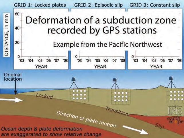
Lecture 20: Slow Slip Events and Stress Transfer. GEOS 655 Tectonic Geodesy Jeff Freymueller
 Lecture 20: Slow Slip Events and Stress Transfer GEOS 655 Tectonic Geodesy Jeff Freymueller Slow Slip Events From Kristine Larson What is a Slow Slip Event? Slip on a fault, like in an earthquake, BUT
Earthquakes & Volcanoes
 Earthquakes & Volcanoes Geology - the study of solid Earth, the rocks of which it is composed, and the processes by which they change geo = Earth; ology = study of Earth s Layers Plate Tectonics - the
83% 25 of 30 Correct. Dynamic Earth Assessment Test Results. Name: Marc Sto. Domingo Date: October 2, 2013
 Dynamic Earth Assessment Test Results Name: Marc Sto. Domingo Date: October 2, 2013 83% 25 of 30 Correct Review the questions and your answers below. The answer you selected is highlighted in red, the
Earth s Dynamic Surface
 Earth s Dynamic Surface Shaping Earth s Surface What do you think? Read the two statements below and decide whether you agree or disagree with them. Place an A in the Before column if you agree with the
Magnitude 7.0 NEW CALEDONIA
 A magnitude 7.0 earthquake has occurred 82km ENE of Maré Island, the secondlargest of the Loyalty Islands in the archipelago of New Caledonia. The initial report of the magnitude and shallow 10km depth
5. What is an earthquake 6. Indicate the approximate radius of the earth, inner core, and outer core.
 Tutorial Problems 1. Where Do Earthquakes Happen? 2. Where do over 90% of earthquakes occur? 3. Why Do Earthquakes Happen? 4. What are the formulae for P and S velocity 5. What is an earthquake 6. Indicate
Tsunami and earthquake in Chile Part 2
 EUROPEAN COMMISSION DIRECTORATE GENERAL JRC JOINT RESEARCH CENTRE Institute for the Protection and Security of the Citizen Global Security and Crisis Management Unit CriTech Sunday, 28 February 2010 Executive
Spatio-temporal variation in slip rate on the plate boundary off Sanriku, northeastern Japan, estimated from small repeating earthquakes
 Spatio-temporal variation in slip rate on the plate boundary off Sanriku, northeastern Japan, estimated from small repeating earthquakes T. Matsuzawa, N. Uchida, T. Igarashi *, N. Umino, and A. Hasegawa
Title. Author(s)Heki, Kosuke. CitationScience, 332(6036): Issue Date Doc URL. Type. File Information. A Tale of Two Earthquakes
Heki, Kosuke. CitationScience, 332(6036): Issue Date Doc URL. Type. File Information. A Tale of Two Earthquakes") Title A Tale of Two Earthquakes Author(s)Heki, Kosuke CitationScience, 332(6036): 1390-1391 Issue Date 2011-06-17 Doc URL http://hdl.handle.net/2115/48524 Type article (author version) File Information
Title A Tale of Two Earthquakes Author(s)Heki, Kosuke CitationScience, 332(6036): 1390-1391 Issue Date 2011-06-17 Doc URL http://hdl.handle.net/2115/48524 Type article (author version) File Information
Tectonic Processes and Hazards Enquiry Question 1: Why are some locations more at risk from tectonic hazards?
 Tectonic Processes and Hazards Enquiry Question 1: Why are some locations more at risk from tectonic hazards? Key words Basalt Andesite Rhyolite Benioff Zone Subduction zone Crustal fracturing Definition
LECTURE #5: Plate Tectonics: Boundaries & Earthquake Science
 GEOL 0820 Ramsey Natural Disasters Spring, 2018 LECTURE #5: Plate Tectonics: Boundaries & Earthquake Science Date: 23 January 2018 I. Reminder: Exam #1 is scheduled for Feb 1st one week from Thursday o
Earthquakes. Pt Reyes Station 1906
 Earthquakes Pt Reyes Station 1906 Earthquakes Ground shaking caused by the sudden release of accumulated strain by an abrupt shift of rock along a fracture in the earth. You Live in Earthquake Country
Measuring EQ, Tsunamis
 16 June 16 Summer Session 2016 Horst Rademacher HH Lect 6: Earth s Interior Measuring EQ, Tsunamis http://seismo.berkeley.edu/~horst/summer2016.html Recap from Midterm Questions 4: Question 8: Question
Megathrust Earthquakes
 Megathrust Earthquakes Susan Schwartz University of California Santa Cruz CIDER 2017 UC Berkeley July 5, 2017 The largest megathrust events are not uniformally distributed at all subduction zones. M>8
Crustal deformation by the Southeast-off Kii Peninsula Earthquake
 Crustal deformation by the Southeast-off Kii Peninsula Earthquake 51 Crustal deformation by the Southeast-off Kii Peninsula Earthquake Tetsuro IMAKIIRE, Shinzaburo OZAWA, Hiroshi YARAI, Takuya NISHIMURA
Earth Science Lesson 3 Dynamic Earth Processes (Grades 8-12 ) Instruction 3-3 Plate Boundaries
 Instruction 3-3 Plate Boundaries") As we told you in a recent Instruction, much of the Earth's lithosphere (its Crust and the top layer of its Outer Mantle) is made up of moving masses of rock called tectonic plates (tectonic means moving).
As we told you in a recent Instruction, much of the Earth's lithosphere (its Crust and the top layer of its Outer Mantle) is made up of moving masses of rock called tectonic plates (tectonic means moving).
General Oceanography Geology 105 Expedition 10 - Whole Lotta Shakin' Goin' On
 General Oceanography Geology 105 Expedition 10 - Whole Lotta Shakin' Goin' On Name Not attempting to answer questions on expeditions will result in point deductions on course workbook (two or more blank
9.3. Earthquakes. Earthquakes at Divergent Boundaries
 9.3 Earthquakes Preview the headings on these two pages. What can you say about where earthquakes occur? As the plates that make up Earth s crust move, the rough edges lock together. Over time, pressure
Earth Movement and Resultant Landforms
 Earth Movement and Resultant Landforms Structure of the Earth Lithosphere : earth s crust Asthenosphere : upper mantle zone where material is near its melting point & acts almost like liquid (appprox.
General Oceanography Geology 105 Expedition 8 Plate Boundaries Beneath the Sea
 General Oceanography Geology 105 Expedition 8 Plate Boundaries Beneath the Sea Name Not attempting to answer questions on expeditions will result in point deductions on course workbook (two or more blank
Tectonic Forces Simulation: Earthquakes Activity One
 Tectonic Forces Simulation: Earthquakes Activity One Introduction If you marked all the earthquakes from the past century on a world map, you'd notice that most tend to occur along certain lines around
Beneath our Feet: The 4 Layers of the Earty by Kelly Hashway
 Beneath our Feet: The 4 Layers of the Earty by Kelly Hashway The Earth is more than a giant ball made up of dirt, rocks, and minerals. The Earth may look like a giant ball from when looking at it from
Lecture Outline Friday January 12 Friday January 19, 2018
 Lecture Outline Friday January 12 Friday January 19, 2018 Questions?? Key Points for today The structure of the Earth Introduction to Plate Tectonic Theory and Convection Chapter 2 Development of the Plate
Crustal Boundaries. As they move across the asthenosphere and form plate boundaries they interact in various ways. Convergent Transform Divergent
 Name: Date: Period: Plate Tectonics The Physical Setting: Earth Science CLASS NOTES Tectonic plates are constantly moving and interacting As they move across the asthenosphere and form plate boundaries
San Andreas Movie Can It Happen?
 San Andreas Movie Can It Happen? Learning Objectives (LO) Lecture 14: Faults and Quakes Read: Chapter 10 and 11 Homework #12 due Thursday 12pm What we ll learn today:! 1. Compare strike-slip to dip-slip
General Oceanography Geology 105 Expedition 8 Plate Boundaries Beneath the Sea Complete by Thursday at 11:00 PM
 General Oceanography Geology 105 Expedition 8 Plate Boundaries Beneath the Sea Complete by Thursday at 11:00 PM Name Expedition Objectives Learn about the types of plate boundaries and their key characteristics
Dynamic Earth Quiz. 4. The accompanying diagram shows some features of Earth s crust and upper mantle.
 DO NOT WRITE ON THIS Dynamic Earth Quiz DO NOT WRITE ON THIS 1. Base your answer(s) to the following question(s) on the diagram below. The diagram shows a model of the relationship between Earth s surface
Earthquakes. Earthquake Magnitudes 10/1/2013. Environmental Geology Chapter 8 Earthquakes and Related Phenomena
 Environmental Geology Chapter 8 Earthquakes and Related Phenomena Fall 2013 Northridge 1994 Kobe 1995 Mexico City 1985 China 2008 Earthquakes Earthquake Magnitudes Earthquake Magnitudes Richter Magnitude
Lithospheric plates. Geology of the Batemans Bay region. Tectonic processes
 1 Lithospheric plates Enormous heat sources in the Earth s deep interior, acquired during the very early history of the planet billions of years ago continue to drive present-day geological at the surface.
Magnitude 7.6 HONDURAS
 A magnitude 7.6 earthquake has occurred in the Caribbean between Honduras and the Cayman Islands approximately 125 miles (202 km) north-northeast of Barra Patuca, Honduras, and 188 miles (303 km) southwest
Magnitude 7.1 PHILIPPINES
 A magnitude 7.1 earthquake struck in the southeastern Philippines just after 8 am local time Tuesday morning killing 82 people and reducing a 17 th century church to rubble. Offices and schools were closed
Date: / Page # Version A Page 1
 Name: Plate Tectonics Quiz 1. Which best describes a major characteristic of both volcanoes and earthquakes? (1) They are centered at the poles. (2) They are located in the same geographic areas. (3) They
INTRODUCTION TO EARTHQUAKES
 INTRODUCTION TO EARTHQUAKES Seismology = Study of earthquakes Seismologists = Scientists who study earthquakes Earthquake = Trembling or shaking of the earth s surface, usually as a result of the movement
Practice Questions: Plate Tectonics
 Practice Questions: Plate Tectonics 1. Base your answer to the following question on The block diagram below shows the boundary between two tectonic plates. Which type of plate boundary is shown? A) divergent
Magnitude 8.2 FIJI. A magnitude 8.2 earthquake occurred km (226.7 mi) E of Suva, Fiji at a depth of km (350 miles).
 E of Suva, Fiji at a depth of km (350 miles).") A magnitude 8.2 earthquake occurred 364.8 km (226.7 mi) E of Suva, Fiji at a depth of 563.4 km (350 miles). There is no risk of a tsunami from an earthquake at this depth. Images courtesy of Google The
A magnitude 8.2 earthquake occurred 364.8 km (226.7 mi) E of Suva, Fiji at a depth of 563.4 km (350 miles). There is no risk of a tsunami from an earthquake at this depth. Images courtesy of Google The
Ch12&13 Test. 3. Where does the first motion of an earthquake occur? a. fault c. epicenter b. focus d. locus
 Ch12&13 Test Multiple Choice Identify the choice that best completes the statement or answers the question. 1. What is the epicenter of an earthquake? a. the location along a fault where the first motion