Modification of karst depressions by urbanization in Pinellas County, Florida
|
|
|
- Darleen Ross
- 6 years ago
- Views:
Transcription


1 University of South Florida Scholar Commons Graduate Theses and Dissertations Graduate School 2004 Modification of karst depressions by urbanization in Pinellas County, Florida Kelly V. Wilson University of South Florida Follow this and additional works at: Part of the American Studies Commons Scholar Commons Citation Wilson, Kelly V., "Modification of karst depressions by urbanization in Pinellas County, Florida" (2004). Graduate Theses and Dissertations. This Thesis is brought to you for free and open access by the Graduate School at Scholar Commons. It has been accepted for inclusion in Graduate Theses and Dissertations by an authorized administrator of Scholar Commons. For more information, please contact
2 Modification of Karst Depressions by Urbanization in Pinellas County, Florida by Kelly V. Wilson A thesis submitted in partial fulfillment of the requirements for the degree of Master of Science Department of Environmental Science and Policy College of Arts and Sciences University of South Florida Major Professor: Robert Brinkmann, Ph.D. Philip van Beynen, Ph.D. H. Leonard Vacher, Ph.D. Date of Approval: October 25, 2004 Keywords: sinkhole, gis, karst, aerial photographs, florida Copyright 2004, Kelly V. Wilson
3 Acknowledgements I would first like to thank my parents, Wayne and Joanne Wilson. Without their constant love, support, and never letting me forget that I could do anything I set my mind to, none of this would have been possible. Thanks Mom and Dad, I love you. Next I would like to thank Dr. Robert Brinkman, who not only gave me this thesis project, but also gave unfailingly cheerful encouragement and advice, and never doubted that I really could do it. Thanks to Dr. H.L. Vacher for allowing me into your lab and always being ready with a quick smile and any geologic advice that I may have needed while circling thousands of sinkholes. An enormous thank you must go to Lee Florea. I would first like to thank him for his technical assistance, without which I would still be sitting in front of ArcGIS wondering how to identify sinkholes, and finally for being so incredibly patient with whatever I was asking of him. Thank you to Dr. Philip van Beynen for offering various viewpoints and helping to shape my final thesis. Thank you to the Department of Environmental Science and Policy for supporting me while pursuing my academic endeavors, and a special thank you to Karen Schrader for always making sure my paperwork was done and always having some candy for a mid-afternoon pick-me-up. I would also like to thank Pinellas County for funding this thesis project and for supplying the aerial photographs which it was based on. A special thanks to my fellow graduate students, especially Bob, Dave, and Lisa, for offering constant support, incredible friendships, and finally a good laugh when I needed it. I love you all. And finally, thank you to my husband Adam, my number one fan, you came late in the game, but kept me focused in the end when I got lazy, convincing me it was only a couple more months. I love you.
4 Table of Contents List of Tables List of Figures Abstract ii iii iv Chapter One Purpose and Introduction 1 Purpose 1 Introduction 1 Karst Landscape 2 Karst Formation 3 Karst Morphology 4 Florida Geology, Geomorphology, Hydrology 6 Florida Geology 6 Florida Geomorphology 7 Florida Hydrology 9 Florida Karst 10 Geomorphology of Sinkholes 11 Classification of Sinkholes 12 Sinkholes in Florida 13 Karst and Sinkholes in Pinellas County 15 Chapter Two Methodology 19 Methodology 19 Data Management 20 Sinkhole Delineation 21 Morphometric Analysis 23 Chapter Three Results Aerial Photos 26 Density, Total Features, Total Area, Percent Area Black and White Aerial Photo Descriptions 28 Northeastern Pinellas County 28 Central Pinellas County 32 Southern Pinellas County Aerial Photos 35 Density, Total Features, Total Area, Percent Area 35 i
5 2000 Color Aerial Photo Descriptions 37 Northeastern Pinellas County 41 Central Pinellas County 41 Southern Pinellas County 44 Chapter Four Discussion and 2000 Aerial Photo Comparison 46 Percent Loss 46 Retention Areas 52 Sinkhole Elevations 52 Chapter Five - Conclusions and Suggestions for Further Research 55 Conclusions 55 Suggestions for Further Research 56 References 58 ii
6 List of Tables Table 1 Karst Landscapes and Descriptions 5 Table Aerial Photo Data 28 Table Aerial Photo Data 37 Table 4 Percent of Sinkholes lost by iii
7 List of Figures Figure 1 Age of Geologic Units in Florida 8 Figure 2 Geologic Map of Pinellas County 17 Figure 3 Data Management Chart 20 Figure 4 Map of Florida Pinellas County Highlighted 27 Figure Sinkhole Map 29 Figure Areas of Exclusion 30 Figure Developed Areas 31 Figure Aerial Photo Northeastern Pinellas County 33 Figure Aerial Photo Central Pinellas County 34 Figure Aerial Photo Southern Pinellas County 36 Figure Sinkhole Map 38 Figure Storm Water Retention Areas 39 Figure Undeveloped Areas 40 Figure Aerial Photo Northeastern Pinellas County 42 Figure Aerial Photo Central Pinellas County 43 Figure Aerial Photo Southern Pinellas County 45 Figure 17 Possible Sinks Present on Both 2000 and 1926 Aerial Photos 47 Figure 18 Sinks Present on Both 2000 and 1926 Aerial Photos 48 Figure 19 Total Sinkholes Present in Both 1926 and 2000 w/ Intersecting Areas 49 iv
8 Figure 20 Intersecting Areas of Sinkholes Present in both 1926 and Figure 21 Sinkholes which formed after Figure Sinkholes Intersecting 2000 Storm Water Retention Ponds 53 Figure 23 Topographic Map with Sinkhole Locations 54 v
9 Modification of Karst Depression by Urbanization in Pinellas County, Florida Kelly V. Wilson ABSTRACT This thesis analyzes some of the effects of urbanization in Pinellas County, Florida on the karst landscape. Many sinkholes have been obscured and/or modified for storm water retention by urbanization in Pinellas County, with a few sinkholes still identifiable by characteristic zoning of vegetation, soil moisture, and circular shape. Using aerial photos from 1926 and 2000, karst features were identified by circularity, vegetation, and moisture conditions. Mapping karst surface features using historic aerial photos and maps is a useful exercise that will assist our scientific understanding of karstification in Florida and the nature and extent of karst processes that have acted in the pre-urbanized past. The final product of this research is a digital spatial database and metadata of karst features discernable on the 1926 and 2000 aerial photos; a description of the karst landscape mapped for each time period; and a morphometric description (including sinkhole area, density, and topography) of the karst landscape mapped for each time period. A total of 2,703 sinkholes were identified on the 1926 aerial photos. By 2000 only 900 sinkholes were still visible, a loss of 87.31%. Most of the loss of these sinkholes was due to the rapid urbanization that happened between 1926 and A total of 499 sinkholes that had been identified in 1926 have now been modified into storm water retention ponds. vi
10 CHAPTER 1 PURPOSE AND INTRODUCTION Purpose The purpose of this thesis is to analyze the effects of urbanization in Pinellas County, Florida, on the karst landscape and to map sinkholes modified through urbanization from 1926 to the present. I believe that the urbanization of Pinellas County has resulted in the filling or modification of sinkholes that were present in the 1926 aerial photos to be filled or modified. I think many of the sinkholes which were modified have become storm water retention ponds. This modification can allow untreated water to enter aquifer systems and thus affect not only Pinellas County, but the rest of Florida as well. The results of this research will be useful to land managers in addressing karst issues in the County and to karst scientists interested in predevelopment karst geomorphology. This introduction will review various aspects of Florida karst systems. Introduction Over 17,000 square miles of the United States has been directly affected by land subsidence with eighty percent of this subsidence being a direct result of development and exploitation of groundwater resources (Galloway and others, 1999). The increasing development of land and water resources threatens to aggravate existing land subsidence problems and initiate new ones. The development of karst terrains is riddled with both environmental and engineering hazards (Wilson and Beck, 1988). Extraction and drainage of ground water play a direct role in land subsidence by causing the compaction of vulnerable aquifer systems and the dewatering of organic soils (Galloway and others, 1
11 1999). In Florida more than 10 million people and countless agricultural interests rely on groundwater supply, thus increasing the possibility of land subsidence and sinkhole formation (Scott, 2002). The formation of sinkholes, one of the greatest karst hazards found in Florida, although fundamentally a natural process, can also be triggered by groundwater level declines caused by pumping, infiltration from reservoir impoundments, surface water diversions, or storm water runoff channels (Galloway and others, 1999). The economic losses due to karst hazards, such as sinkholes, are largely hidden because they are spread across an area the size of a state. The only way to completely avoid economic and environmental damage from human activity on karst terrain is to avoid building on karst, but the demands of economic growth are applying overwhelming pressure to develop these areas (Cobb and Currens, 2001). According to a report published by the Florida Sinkhole Research Institute (FSRI) Florida s rapid urban development dramatically increases the threat and the dangers of sinkhole collapse, particularly in the state s urban areas. Unprecedented growth, patterns of drought, and increased water well pumping increase the likelihood of extensive future sinkhole formation activity. Increased risks will accompany continued development. (FSRI, 1983) Karst Landscape The term karst (Slavic kras) means literally, a bleak waterless place (Sinclair and others, 1985). Karst is defined in the Glossary of Geology as a type of topography that is formed on limestone, gypsum and other rocks, primarily by dissolution, and that is 2
12 characterized by sinkholes, caves, and underground drainage (Bates and Jackson, p.337, 1980). Karst is terrain with distinctive hydrology and landforms arising from a combination of high rock solubility and well-developed secondary porosity. Karst is synonymous with limestone landscapes; however, other soluble rocks such as dolomite, gypsum, and salt show karstification in some regions (Bloom, 1998). A true karst area has predominately underground drainage with a poorly developed surface network of streams. Karst landscapes are common in humid, temperate climates where ample free water is available to circulate, but the greatest abundance and variety of karst landscapes are located in warm, tropical environments with lush vegetation and abundant rainfall, and are underlain by other soluble rock (Kochel and others, 1995). About 15 percent of the area of the conterminous United States has karst-prone rocks at or near the surface, and about 12 percent of the earth s land area has exposed carbonate rocks although not all of it shows karst landforms. The most notorious karst region in the United States for construction and groundwater problems is Florida and parts of Georgia, Alabama, and Kentucky. Other areas of the world facing karst problems include Turkey, Greece, Italy, France, Spain, the Middle East, and northern Africa (Kochel and others, 1995). Karst Formation Two things are necessary to create the karst terrain present in Florida: carbonate rocks and slightly acidic water to dissolve them (Lane, 1986). The solution of limestone in a karst terrain is essentially the solution of CaCO 3, by downward moving water which is accomplished through the CaCO 3 -CO 2 -H 2 O chemical reaction. This is an epigenic process that is driven by the hydrologic cycle. Limestone solution, and therefore karst, is 3
13 also affected by biologically generated CO 2 in decaying humus. Animals and plants can corrode limestone directly as well as create biochemical conditions that slow down solution or promote deposition of sediments (Bloom, 1998). The solution process can create and enlarge cavities within karst rocks. This leads to the progressive enlargement of voids beneath the surface allowing large amounts of water to be directed into an underground drainage system, possibly disrupting the pattern of surface flow. Creation of karst depends on how much water any rock can hold and how easily the water moves through the rock system; these two characteristics are known as porosity and permeability. Open textures and higher secondary porosity facilitate the solution process and the development of karst (Kochel and others, 1995). Karst Morphology Two important physical characteristics of karst are lithology and rock permeability. Most karst forms on limestone, which is an extremely diverse rock type. To be defined as a limestone, a rock should contain more than 80 percent calcium and magnesium carbonate, but many limestones contain sand, silt, and clay (Bloom, 1998). Limestones can have granular textures and considerable porosity and permeability (Lane, 1986). Karst limestones in general are quite pure. Karst landscapes can develop their own distinctive geomorphology. Table-1 lists several landscape types and their characteristics. An estimated 25 percent of the Earth s human population is supplied with most or all of their waters from karst aquifers (Galloway and others, 1999). Much of the water flows rapidly through conduits from point sources in the bottom of sinkholes, and discharges at springs or into rivers or the sea. The complex conduit system of karst 4
14 aquifers are not all interconnected as explained in the following paragraph (Bloom, 1998). Aquifers are subsurface zones of rocks or sediments that yield water in sufficient quantities to be economically useful for man s activities. Aquifers can be unconfined, semi-confined, or confined. Unconfined aquifers contain water that is in direct contact with the atmosphere. The zone of sediments or rocks saturated with water is the vadose zone, and is referred to as a surficial or water-table aquifer. The water table Most common and widely distributed landscape; are spotted Doline karst with sinkholes of varying size Typically found in sub-tropical and tropical climates; very Cockpit karst similar to doline karst but have low depression densities with high sinkhole area ratios Thick massive limestone and well-developed fracture system. Cone and Tower karst Isolated blocks surrounded by alluvial plains. Abnormal drainage, blind valleys. swallow holes, large springs, closed depressions, and caves. Larger rivers maintain Fluviokarst their surface courses and are often fed by underground tributaries. Areas of bare limestone, usually sculpted into karren of Pavement karst various types. Occur in alpine terrains where soils are thin or stripped by glaciation. Covers very large areas; Consists of poljes which are very Polje karst large closed depressions; requires a great thickness of carbonate rocks. Dominated by intersecting solution corridors and solution Labyrinth karst canyons. Regions where limestones and other soluble rocks crop out at the surface, there are caves and a well-developed underground Cave karst drainage, and little surface expression in the form of closed depressions or other karst landforms is found. Table 1. Karst landscapes and descriptions (White, 1988 p ). is the top of the zone of saturation. Semi-confined or confined aquifers are separated from direct contact with the atmosphere by impermeable material, such as clay beds or 5
15 consolidated rocks. Confinement may impose pressure on the contained water and create artesian conditions (Lane, 1986) Springs are expressions of flow from a water-table, semi-confined, or a confined aquifer. When downward percolation of water is impeded by a confining layer the water is forced to move laterally, downslope, and discharge where the permeable sand and less permeable clay intersect the land surface (Lane, 1986). These terms are important when discussing Florida karst systems. A review of Florida karst hydrology and geomorphology follows. Florida Geology, Geomorphology, Hydrology The following section discusses the geology, geomorphology, and hydrology in Florida. The Florida Platform is believed to have been part of the West African continental margin near Sengal and was rifted from that margin during a Triassic breakup. Geochemical and geochronologic data have provided support for the proposed correlations of Florida basement terrains with the West Africa and northeastern South America (Heatherington and Mueller, 1997). Florida Geology The entire Florida Platform is covered by a blanket of carbonate sediments ranging in age from Miocene to Holocene. Older sediments are exposed only along rivers and streams and in sinkholes that cut through younger sediments. Younger sediments were deposited under marine conditions (Scott, 1997). The Florida peninsula most likely emerged from a submarine environment during the Neogene (Smith and Lord, 1997). 6
16 The carbonate formations of Florida are generally dolomitic limestones, with varying amounts of interbedded evaporites; they represent peritidal and subtidal shelf environments of deposition, reflecting small and large scale sea-level fluctuation (Randazzo, 1997). Dolostones are the dominant carbonate sediments in the northern twothirds of the peninsula while limestone predominates in the southern peninsula and in the eastern panhandle area (Scott, 1992). Figure - 1 visually depicts the geology of the state of Florida. Florida Geomorphology Marine and coastal processes have been the dominant factors in shaping and modifying the Florida platform as well as the exposed peninsula (Scott, 1988). The western edge of the Florida platform lies over 160 kilometers west of Tampa. The eastern edge lies only 4 or 6 kilometers off the coast of Miami, dropping off steeply to abyssal depths of more than 3 kilometers, creating what is known as the Florida escarpment (Lane, 1994). The portion of the Platform that is above sea level, the peninsula, comprises the state of Florida. Sediments were eroded from the southeastern coastal plain and southern Appalachians as the siliciclastic coastal plain advanced southward toward the Gulf of Mexico. Sediments eventually filled the Gulf trough and spilled onto the carbonate platform. These sediments covered the limestone and formed the spine of clayey sands on the peninsula. Subsequent sea-level changes altered these deposits and modified the elongated system of upland ridges identified on Florida s present landscape (Schmidt, 1997). The following section describes the hydrology of the Florida peninsula. 7
17 Figure 1. Age of Geologic Units in Florida. (FGS website, taken on 9/9/2003). 8
18 Florida Hydrology Across most of the state, highly permeable soil or rock is present at or near the land surface. Drainage density is low, but surface-water features include extensive wetlands and more than 7,700 lakes. Many of the lakes that occur in central and western Florida occupy basins formed by sinkholes that are the result of dissolution of part of the limestone bedrock. Water levels in these lakes fluctuate directly with variations in aquifer levels. Water levels in many Florida streams also depend on aquifer levels. The rise and fall in the river stage is generally paralleled by rise and fall in aquifer water levels both of which change in response to precipitation (Miller, 1997). There are five principal aquifers or aquifer systems in Florida. Four of these crop out at the land surface or are covered by a thin layer of soil and/or weathered rock; the fifth, the intermediate aquifer system of southwestern Florida, is completely buried by shallower aquifers or confining units. The Floridan aquifer system extends in the subsurface throughout the state and is the most prolific aquifer system in the region (Miller, 1997). Miocene sediments compose the confining unit of the Floridan aquifer system, Miocene-Pliocene sediments form the intermediate aquifer system, and Pliocene- Pleistocene sediments make up the shallow aquifer system (Scott, 1997). Recharge to the aquifer system occurs over approximately 55 percent of the state as rainwater infiltrates the overlying sediments. Recharge rates vary from less than 2.5 cpy to more than 25 cpy depending on location (Scott, 1992). The geomorphology of the state, along with the geologic framework, controls the distribution of springs throughout the state. The springs occur where karst features are common and the surface elevations are low enough to allow groundwater to flow at the 9
19 surface (Scott & others, 2002). Florida has 300 known springs with a combined estimated discharge of about 12,600 cfs or eight billion gpd (Lane, 1986). Florida has 33 first-magnitude springs, more than any other state or country. First-magnitude springs discharge more than 64 million gallons of water per day or more than 100 cfs (Scott, 2002). All of Florida s major springs discharge from the Floridan Aquifer, which is estimated to hold more than 2.2 quadrillion gallons of fresh water. The water flowing out of these springs allows a window into the aquifer, thus assisting in determining the health of the aquifer (Scott, & others, 2002). The following section will summarize the many karst features found in Florida. Florida Karst Karst development in west-central Florida is controlled by lithology and water movement, dissolution by chemically aggressive water, aquifer material, and sea levels (Sinclair and others, 1985). Limestone dissolution in Florida has been intense because of the warm climate, heavy precipitation, low relief that encourages infiltration, and multiple Pleistocene sea-level changes of 100 meters or more (Bloom, 1998). Florida is almost entirely underlain by carbonate rocks, almost all of which are limestone or dolomite. The carbonate-evaporite sequences of Florida are extremely vulnerable to recrystallization, replacement, dissolution, and cementation. This diagenesis of Florida s carbonate rocks has produced significant changes in rock makeup and has facilitated the development of many types of pore spaces including moldic, vug, and interparticle pore. Areas with extensive dissolution can create caves and caverns, which are the underlying essentials of karst landscapes (Randazzo, 1997; Lane, 1986; Scott, 1992). 10
20 Karst drainage in Florida is characterized by sinkholes, springs, caves, disappearing streams, and underground drainage channels. Chemical weathering is the predominant erosive process that forms the karst terrains like the ones found in Florida. Limestones, by nature, tend to be fractured, jointed, laminated, and have units of differing texture, all characteristics which, from the standpoint of percolating ground water, are potential zones of weakness, which can be enlarged and extended by acidic rain water (Lane, 1994; Scott, 1992). Chemical weathering of limestone is the ultimate cause of land subsidence such as sinkhole development, but localized stress may also trigger overburden collapse into preexisting cavities. Most of Florida s more than 7,700 lakes are solution-based lakes created by groundwater solution of underlying limestone and subsequent lowering of local land surface. These lakes as a result, have physical characteristics of sinkholes such as relatively steep sloping sides, no surface streams into or out of them, and circular outlines (Lane, 1986). Geomorphology of Sinkholes The term doline (sinkhole) describes a particular landform produced by karst processes. Dolines are characterized by circular depressions and underground water drainage networks (Tihansky, 1999). Identically shaped closed depressions can form by subsidence, volcanism, wind deflation, glaciation or any other process that selectively displaces a mass of rock and permits the surrounding material to slump into the excavation. Some sinkholes have gently sloping sides, while others, especially those known as collapse sinks, have vertical or overhanging cliffs. Sinkholes are usually circular in plan 11
21 view and less commonly elongate or oval. Sinkholes range in size from shallow soil depressions a few meters in diameter and a meter deep to major landforms several kilometers in diameter and hundreds of meters in depth (Bloom, 1998). Factors that initiate and enlarge sinkholes include: groundwater recharge, secondary porosity, overburden thickness and sheer strength, and hydraulic gradient. The initiation and enlargement of primary sinkholes leads to the generation of secondary sinkholes. Mixed sinkhole populations, those with primary and secondary sinks, can exist within the same karst area (Kochel and others, 1995). Sinkholes not only have an impact on surface land features but also have an impact on hydrological systems such as lakes, streams, and wetlands by changing water chemistry and rates of recharge or runoff (Tihansky, 1999). Classification of Sinkholes Five major classes of sinkholes or dolines are recognized. The two most contrasting types are the funnel-shaped solution/subsidence doline and the steep or cliffed collapse doline. Subsidence dolines and collapse dolines are surface forms in nonsoluble rock, caused by solution of buried karst (Bloom, 1998). Most sinkholes are a combination of the solutional and collapse types. Solution sinkholes form as water infiltrating into joints and fissures enlarges the cracks by corrosion. A cone depression is produced in the perched water table as downward flow rates in the enlarged fractures exceed that of the surrounding area. Collapse sinkholes are depressions that are initiated by solution that occurs beneath the surface. The expansion of caverns, caused by corrosion and reduction of buoyant support 12
22 may lead to collapse by decreasing the support of the overlying rock material (Kochel and others, 1995). The following section discusses sinkhole formation in Florida. Sinkholes in Florida Sinkholes are a predominant landform in Florida; with west-central Florida being delineated as having the highest frequency of sinkhole activity. Sinkhole formation commonly damages buildings, roads, and utilities, diminishing the usefulness of the affected land. Millions of dollars are lost each year in Florida because of structural damage caused by sinkholes (Upchurch and Randazzo, 1997). The Florida Sinkhole Research Institute conservatively estimated that sinkholes cause approximately $10 million in damage each year in the state of Florida (Beck and Sayed, 1991). The occurrence of sinkholes has become more frequent with the increased development of ground water and land resources (Tihansky, 1999). Dissolution of limestone in Florida appears to occur preferentially in recharge areas, such as sinkholes and wetlands, and near the saltwater/freshwater coastal mixing zone. Recharge environments are the more important of these two environments for sinkhole development (Upchurch and Randazzo, 1997). Sinkholes are more common where the Floridan aquifer system is unconfined or thinly confined (Miller, 1997). The multiple stages of the development of karst in Florida have resulted in a number of different types of sinkholes present in the state. The most common are collapse and solution sinkholes. Collapse sinkholes form when limestone substrate has layers of clays and sands overlying it, and a cavern below. If the cover is cohesive and thick enough, it may be able to bridge a cavern in the absence of a limestone roof. When 13
23 the cover eventually collapses, a large funnel shaped depression results. Solution sinkholes form as a result of dissolution of rock. The geologic framework is similar to that of a collapse sinkhole, with the exception that a group of nearly vertical joints is present. If water passes vertically along the joints, they will become enlarged by dissolution. The removal of rock by dissolution allows settling of rock and washing of overburden into the cavern. Consequently slow subsidence occurs (Tihansky, 1999). Because there is a long history of karstification in Florida, sinkholes vary in age and degree of development. Many of the older sinkholes have been partially filled by marine and wetland sediments. These older, partly to completely filled sinkholes are called alluvial sinkholes (Upchurch and Randazzo 1997). Where the water table is shallow, they form lakes and cypress domes. Rejuvenated alluvial sinkholes are sometimes called raveling sinks. Alluvial sinkholes are reactivated by a number of different processes. Where heavy pumping is present, especially for agricultural freeze protection when the water table is low, many sinkholes become reactivated. Turbulent flow causes erosion and reduction of the hydraulic head in the limestone aquifer reducing buoyancy and support of the overburden. The erosion is initially accompanied by loss of cohesion and upward piping. Settling and cracking begins, the failure works upward until the cover can no longer be supported, and finally rapid subsidence begins (Tihansky, 1999). Sinkholes can operate as pathways of local or regional groundwater contamination. In the past, sinkholes were considered to be convenient, low-cost wastedisposal sites. Because karst areas typically have internal drainage, agricultural wastes, lawn fertilizers, and other sources of nutrients are unintentionally washed into the 14
24 sinkholes, and eventually into the aquifers below. These excess nutrients can cause enrichment of surface waters and groundwater (Upchurch and Randazzo, 1997). Karst and Sinkholes in Pinellas County Surficial evidence of a karst landscape in Pinellas County is limited to sinkholes, sinkhole associated features, and springs. These features provide distinct problems for planners and environmental scientists in the region. Land stability is perhaps the largest issue for citizens of Pinellas County; with contaminant transport through karst features, water quality, and hurricanes on the forefront as well (Schmidt, 1997). At least 500 homes have been damaged by sinkholes in Pinellas County, Florida between 1990 and 1994, according to the county property appraiser (Hutchinson, 1994), with more forming every year. Sinkholes can form from a variety of processes. Those found in Pinellas County are cover-collapse sinkholes that form when Pleistocene sands above limestone collapse into cavities in the bedrock (Schmidt, 1997). Pinellas County is a peninsula, consisting of a mainland and several barrier islands or keys, and is part of the Gulf Coastal Lowlands physiographic region as described by White (1970). This area consists of low-angle scarps and terraces formed during several Pleistocene sea-level stands as illustrated in Figure 2 (White, 1970). In Pinellas County the overburden materials are generally thicker, 9 60 meters thick, and less permeable than in other areas of this region. Greater cohesion of the clay in this area postpones failure, and ultimate collapse tends to occur more abruptly in the form of cover collapse sinkholes (Tihansky, 1999; Frank and Beck, 1991). The uppermost consolidated rock in Pinellas County is Tampa limestone, which is white to light yellow, soft, moderately sandy and clayey, finely granular, and locally fossiliferous, with high 15
25 porosity. Recharge to the aquifer in areas where this limestone is present is likely concentrated at sinkholes. The water table in the surficial aquifer in this area generally lies within a few meters of the land surface. Water in the Floridan aquifer in Pinellas County is under artesian pressure and will rise in tightly cased wells to a level above the clay confining layer. Movement of water from the surficial to the Floridan aquifer is greatly accelerated where the clay is absent or has been breached by sinkhole collapse or subsidence (Lane, 1986). Pinellas County has limited potable water supplies and depends on water delivered from the surrounding counties of Pasco and Hillsborough (Broska and Barnette, 1999). Recent occurrence of sinkholes has been related to abrupt water-level declines caused by pumping. Collapse and subsidence is caused, not by recent solution of limestone but by downward movement of the unconsolidated surficial material that overlies and fills existing cavities in the rock filling voids in which water has been removed (Sinclair, 1982). The surficial aquifer system in the area is recharged almost entirely from local precipitation. In much of west-central Florida water moves downward from the surficial aquifer system to recharge the Upper Floridan aquifer. The karst is mantled and less apparent at the land surface, except when the overburden collapses or subsides into a subsurface cavity. Many small sinkhole-like depressions occur in Pinellas County, but only a few are directly connected to the underlying limestone. The ones that are directly connected to the Floridan aquifer are near the coast and the Upper Floridan aquifer contains saline water in these areas. (Trommer, 1987) 16
26 Figure 2. Geologic Map of Pinellas County, Florida. Qbd beach ridge and dune; Qh Holocene sediments; Qu undifferentiated sediments; TQsu shelly sediments of Plio- Pleistocene age; Th Hawthorn Group; Arcadia Formation, Tampa Member. (Modified from the FDEP Geodata Library, taken on 09/09/03). 17
27 Because of its mild subtropical climate, Pinellas County has become the most densely populated county in the State of Florida, with a population that is currently more than 900,000. The following chapter describes the methodology used to perform the digitization of sinkholes and to determine the loss of sinkholes to urbanization in Pinellas County, Florida. 18
28 CHAPTER 2 METHODOLOGY Methodology Pinellas County, in west-central Florida, is located in one of the more active and least understood karst region of the world. Some of the more common karst features found in this area are dolines, also known as sinks and sinkholes. The topographic expression of these depressions is partially masked by Holocene sand deposits and recent urban development. Urbanization results in filled depression features and modifications for storm water retention. Mapping and analysis of pre-and post-development sinkholes have not been completed in order to assess the distribution of sinkholes and document changes in topography due to urbanization in Pinellas County. This is problematic in that Pinellas County, like much of the Tampa Bay region continues to urbanize rapidly and is likely to undertake significant construction projects that have the potential to directly impact the karst landscape. Without a clear understanding of where karst processes are still active, it is difficult to implement the appropriate land use and management decisions suitable for the geology and population of the region. As Pinellas County moves toward redevelopment of lands, it will be important to understand the former landscape that once existed in order to make appropriate land use decisions. It is clear from studies of sinkholes in undeveloped portions of Florida that they occur in particular clusters or sinkhole regions. Regions of past sinkhole formation are locations where modern doline formation may also occur. Certainly there are such regions that are hidden by the urbanized nature of areas such as Pinellas County. In this 19
29 study, karst features will be identified by circularity, vegetation and soil moisture variations. Mapping karst surface features using historic aerial photos and maps will be a useful exercise that will assist our scientific understanding of karstification in Florida and the nature and extent of karst processes that have acted in the pre-urbanized past. The methods for completing this research follow and are outlined in Figure 3. DATA Sources Management Collection Analysis 1926 Air Photo s 2000 Air Photo s ArcGIS Digitization Identification Criteria Loss to Urbanization Morphometric Figure 3. Data Management Chart. Data Management I have constructed a spatial database for this project. The database includes historic aerial photos from 1926 and more recent photos from The photos were acquired from the Pinellas County government. The digital topographic maps that are the framework for the GIS maps in the County were obtained from the Florida Geographic Data Library, University of Florida. The metadata for these base maps are the foundation on which GIS layers were created for this study. 20
30 The 1926 aerial photos required georeferencing within ARCGIS (ESRI) due to their age and lack of a geographic projection. The 1926 aerial photos are georeferenced first by being projected into the Albers coordinate system, using Datum D North American 1983 (NAD83). I then inserted them into the table provided by Pinellas County to their approximate locations. Next, I had to georeference each photo to either a geomorphic detail found on the topographic maps or anthropogenic markers, such as bridges and roads. The photos are then rectified to their actual geographic location. This was accomplished by stretching the photos within ArcGIS. Finally, I constructed GIS layers of karst features identifiable on the historic, black and white 1926 air photos. There are four layers in this map including features I have discerned as sinks and possible sinks, a layer for exclusions, or areas that were obscured or unclear in the photos and a layer for developed areas, these areas showed notable development such as clusters of roads and/or structures, with the smallest identifiable area being km 2. I then constructed GIS layers of karst features identifiable on the 2000 air photos, which are full-color high-resolution infrared images. Theses images were already georeferenced and thus required nothing more than simple insertion into a new ArcGIS map. This map contains four layers including the features I have identified as sinks, possible sinks, storm water/retention ponds, and undeveloped areas. These areas consisted of wetlands and forests, with the smallest identifiable area being 0.32 km 2. Sinkhole Delineation Specific karst features, such as sinkholes are often recognized by their signatures, or combination of image characteristics, which include tone, texture, shape, size, shadow, height, and spatial relationship. Many sinkholes have been obscured by urbanization in 21
31 Pinellas County, but numerous sinkholes should be definable by characteristic zoning of vegetation and soil moisture, which will still persist even after human alteration or infilling (Lyon and McCarthy, 1995). Surface properties such as mineralogy, textures, color, and moisture differences can be identified on aerial photos (Coker, 1969). Sinkhole indicators that I will be using include: vegetation changes/variation; water presence/absence; soil moisture; and shapes. The sinks layer on both the 1926 and 2000 aerial photo maps are features that I concluded were most likely sinkholes. The criteria used to identify these features were circular and/or combined circular shapes, forming uvalas or coalescing sinkholes. Where a depression contour enclosed two of more subsets of closed depressions, the entire feature is treated as a single sinkhole. The possible sinks layer on both the 1926 photos and 2000 photos are areas of possible sinkhole activity lacking an entirely circular shape, but showed other signs such as soil moisture variations, some circular form, presence of water and indicator vegetation. Lakes that appeared to be depressions on the aerial photographs were treated as karst features and according to their shape where categorized as either sinks or possible sinks. The sinks and possible sinks layers were each identified in layers of different colors. On the 2000 aerial photos I also created a retention pond layer, identifying areas that I considered man-made structures. The criteria I used to identify these areas were straight edges on at least one side of the depression, and the presence of water or soil moisture. The smallest identifiable retention pond feature identifiable on the 2000 aerial photos had an area of 260 m 2. 22
32 The 1926 aerial photos were taken during the dry season in Florida- March, April, and May - so it must be noted that many of the sinks which would normally contain water, and thus be more easily identified, were dry, so vegetation patterns and geomorphology were used to identify the circular patterns. It must also be noted that these criteria were difficult ones with which to work. The 1926 aerial photos are black and white and of very poor quality due to age, technology available and loss of resolution due to scanning of images (pixilation). Consequently many areas of these photos are completely blacked out and thus an exclusion layer was created to remove these areas when carrying out density estimates and other analyses about sinkholes in the County. Complete resolutions of some of the photos, both 1926 and 2000, is obscured on some frames by cloud cover and reflection from water bodies and thus were unreadable. Littlefield (1988) defined sinkholes as an area on topographic maps enclosed by closed depression contours, whether circular or irregular in shape. The minimal diameter at which a sinkhole could be recognized on the topographic maps used in his study was estimated to be kilometers. Small sinkholes were not identifiable due to small surface areas (Littlefield, 1988). The resolution of the 1926 aerial photos allowed sinks and possible sinks with a minimal area of approximately 89 m 2 to be identified. The high quality resolution of the 2000 aerial photos would seem to allow for greater recognition of sinkholes with a minimal area smaller than those in the 1926 aerial photos, but the smallest identifiable sinks and possible sinks were approximately 170 m 2 in area. Morphometric Analysis I calculated morphometric characteristics of the identified features using ArcGIS. ArcGIS automatically calculated the area within the attributes table. The sinkhole 23
33 density in Pinellas County is determined for 1926 and 2000 using numbers supplied by ArcGIS. US Census Bureau figures (2000) for the Pinellas County estimate the total area to be 1,574 km 2, with a land area of 725 km 2 (the figure I used to determine the density). ArcGIS automatically calculated the total area in square kilometers for each layer. I then used these numbers to calculate the density for each layer in 1926 and 2000, using the following calculation: D = density N = number of sinks T = total land area D= N/T I then determined the percent of land area that was covered by the sinks for each layer in 1926 and 2000, using the following calculation: P = K/T P = land area covered K = total square kilometers of each individual layer T = total land area To asses the effects that urbanization has had on the sinks of Pinellas County I then combined many of these calculations and maps to assess the modifications that have occurred. First I calculated the loss of the features that were identified. The calculation used: L=A/B L = loss of sinkholes A = 1926 identified sinkhole area B = 2000 identified sinkhole area 24
34 I then created a map with a layer consisting of the total sinks from 1926 and a layer of the total sinks from I then used the intersect function in ArcGIS, and the results were the sinks that are still present in I then used the map previously described and intersected it with the 1926 total sinkholes map. This map illustrated sinkholes that have formed since the 1926 aerial photos were taken. I also attempted to determine which sinkholes that were identified in 1926 have now been converted into storm water and/or retention pond areas in the 2000 aerial photos. To do this I created a new map which consisted of a layer of the total sinks identified in 1926 and the retention pond layer from 2000, and preformed an intersect function in ArcGIS. This intersected the areas from the 1926 total sinks layer and the 2000 retention pond layer that overlapped. Finally, I took the 1926 sinkhole map and the 2000 sinkhole map and combined them with a topography map. This illustrated the sinkholes and at what elevation they occurred. The final product of this research is a digital spatial database of karst features discernable on the 1926 and 2000 air photos; a description of the karst landscape mapped for each time period; and a morphometric description (including sinkhole area, density, and circularity) of the karst landscape mapped for each time period. With these data I hope to be able to characterize the karst landscape and determine a loss of karst landforms due to urbanization. 25
35 CHAPTER 3 RESULTS Pinellas County, in West Central Florida (Figure 4), is located in one of the more active and least understood karst region of the world. Surficial evidence of a karst landscape is limited to sinkholes, sinkhole associated features, and springs in this county. The topographic expression of these depressions is partially masked by Holocene sand deposits and recent urban development. Urbanization results in filled depression features and modifications to others for storm water retention. The following information is the result of the digitization of the 1926 and 2000 aerial photos of Pinellas County Aerial Photos The 1926 aerial photos acquired from Pinellas County are the foundation of the calculations, inferences, and results within this thesis. Density, Total Features, Total Area, Percent Land Area The number of sinks identified in the 1926 aerial photos is 1,570. They cover km 2. The density is 2.20 sinks per km % of Pinellas County is covered by sinks (Table 2, Figure 5). The number of possible sinks identified is 1,133. They cover km 2. The density is 1.59 possible sinks per km % of Pinellas County is covered by possible sinks (Table 2, Figure 5). Together, the identified sinks and possible sinks (collectively called sinkholes in this thesis) are 2,703 in number, 43.9 km 2 in area, and 3.79 km 2 in density. They cover 6.20% of the total land area of Pinellas County (Table 2). 26
36 Figure 4. Map of Florida Pinellas County highlighted. 27
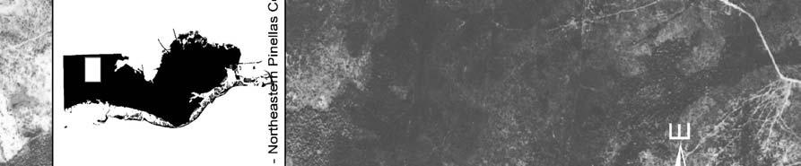
37 Areas of exclusion covered km 2 of Pinellas County, which accounted for 1.58% of the total land area of the county (Table 2, Figure 6). Total # of Features Total Area (km 2) Density (per/km 2 ) Percent Land Area (%) Sinks Possible Sinks Exclusions N/A N/A 1.58 Undeveloped N/A N/A Combined Sinkholes Table Aerial Photo Data. Total area, density, and percent land area of sinkholes, combined sinkholes, possible sinkholes, exclusion areas, and undeveloped land mapped using the 1926 air photos. As part of the analysis of the 1926 aerial photos, I examined the amount of land that was undeveloped in the county. The undeveloped areas of Pinellas County accounted for km 2. This accounts for 85.46% of the total land area in Pinellas County (Table 2, Figure 7) Black and White Aerial Photo Description A total of 36 black and white aerial photos were taken in The following photos and descriptions are a sample of 3 photos from the northeastern, central, and southern parts of Pinellas County. The barrier islands were excluded in this comparison due to the lack of karstic formations and sinkhole activity. Northeastern Pinellas County The photo in Figure 8 is located in the northeastern portion of Pinellas County. To the East is Hillsborough County, and to the North is Pasco County. In 1926 this portion of Pinellas County was completely undeveloped, except for one road which is 28
38 Figure sinkholes. 29
39 Figure Areas of Exclusion. 30
40 Figure Developed Areas. 31
41 is visible in the southwestern area of the photograph. Karstic formations are clearly visible in this aerial photo. The majority of this photo is covered by a highly karstified landscape. In the eastern portion of this aerial photo many sinkhole features are visible, most of which have formed into uvalas or coalescing sinkholes. The majority of this photo appears to be wetlands, although it is difficult to determine due to age and quality of the photo. These wetlands likely formed as a result of the karstic activity. Central Pinellas County Figure 9 is located in central Pinellas County. By 1926 development was rapidly spreading to this area, thus much of the karst landscape was being converted into urban areas as well as farmlands. This photo is very dark and thus some features are difficult to discern, but there are several sinkholes still visible in this area. Many roads have been cut into the landscape, as well as several homes. In the southeastern portion of this photo there are six sinkholes visible, with roads or possibly trails, connecting them. It is possible that they were used as a water supply for the human population or farming activities. In the central area of the photo it appears as though there are several karst features including sinkholes and uvalas. Five of these sinkholes are single sinks with the most northern being a coalescing sink. The individual sinks range from approximately 50 to 150 meters in diameter, with the coalescing sink being approximately 300 meters in diameter. In the south-central portion of this photo is a perfectly formed sinkhole, as well as another in the southwestern portion of the photo. Both of these sinks appear to be approximately 150 meters in diameter. In the southwestern portion of the photo there also appears to be a coalescing sinkhole approximately 5 meters from a road bed. This sinkhole is approximately 500 meters in diameter. 32


42 Figure Aerial Photo Northeastern Pinellas County photo. 33


43 Figure Aerial Photo Central Pinellas County. 34
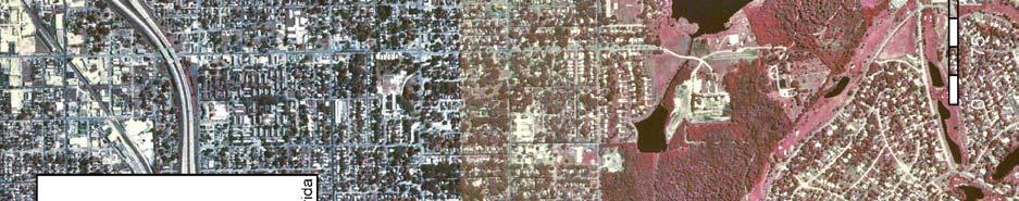
44 Southern Pinellas County Figure 10 is southern Pinellas County. This area was, and is now, known as St. Petersburg. This is the largest city in Pinellas County, and by 1926 was almost completely developed. As can be seen in the image, this area of Pinellas County was fully developed, thus many of the sinkholes that may have previously existed most likely have been filled or modified. There are still several sinkholes that appear in the photo. In the northeastern corner of the photo there is a sinkhole which has been named Mirror Lake. It appears to be a coalescing sink and is approximately 500 meters in diameter. In the west-central portion of this photo there appears to be several sinks within close proximity of each other. They range from approximately 50 to 300 meters in diameter Aerial Photos The 2000 aerial photos acquired from Pinellas County are the basis for the following calculations and maps. Density, Total Features, Total Area, Percent Land Area The number of sinks identified in the 2000 aerial photos is 261, covering 1.60 km 2, with a density of 0.36 sinks per km 2. This land area accounts for 0.22% of Pinellas County (Table 3, Figure 11). The number of possible sinks identified was 639, covering 3.97 km 2, with a density of 0.88 possible sinks per km 2. The possible sinks cover 0.55% of Pinellas County (Table 3, Figure 11). As noted previously, sinks and possible sinks are collectively going to be called sinkholes throughout the rest of this section. A combined total of 900 sinkholes were identified with a combined total area of 5.57 km 2, a combined density of 1.24 sinkholes per km 2. The sinkholes covered a combined 0.77% of the 35


45 Figure Aerial Photo - Southern Pinellas County. 36
46 total land area of Pinellas County (Table 3). The areas identified as retention ponds/storm water features are areas that had at least one straight edge and appeared to be manmade. There were 1,646 retention ponds identified, covering km 2 of Pinellas County with a density of 2.27 retention pond features per km 2. They accounted for 1.83% of the total land area of the county (Table 3, Figure 12). I also calculated the area of undeveloped land in the County. The undeveloped areas of Pinellas County accounted for km 2, which is 2.74% of the total land area in Pinellas County (Table 3, Figure 13). Total # of Total Area Density Features (km 2 ) (km 2 ) Percent Land Area Sinks Possible Sinks Retention Ponds Undeveloped N/A N/A 2.74 Combined 900 Sinkholes Table Aerial Photo Data. Total area, density, and percent land area of sinkholes, combined sinkholes, possible sinkholes, exclusion areas, and undeveloped land mapped using the 2000 air photos Color Aerial Photo Descriptions The following photos and descriptions are a sample of 3 of the 2000 aerial photos. They are located in the northeastern, central, and southern parts of Pinellas County. The barrier islands were excluded in this comparison due to the lack of karstic formations and sinkhole activity. 37
47 Figure Sinkholes. 38
48 Figure Storm Water Retention Areas. 39
49 Figure Undeveloped Areas. 40
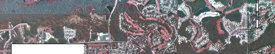
50 Northeastern Pinellas County Figure 14 is a 2000 aerial photo located in northeastern Pinellas County and corresponds to the 1926 photo that was previously described in Figure 8. As can be seen in this photo this portion of Pinellas County is still partially undeveloped. There are large areas in this photo that are still natural wetland areas. Due to the colorization of these photos the karstic features, including sinkholes can be identified by vegetation. As can be seen, there are several large storm water retention features in this photo. All of these retention features were former sinkholes as will be seen in the next chapter. The east-central region of this photo is scattered with various sinkholes identified by a greenish-gray color. The rest of the photo is covered by urbanization, including housing developments and golf courses. Central Pinellas County Figure 15 is a 2000 aerial photo located in Central Pinellas County and corresponds to the 1926 aerial photo that was previously described in Figure 9. This photo is a very good example of what has become of Pinellas County by the year This area of Pinellas County has undergone rapid urbanization as can be seen when compared with Figure 9. This area would most likely be considered a build out, with no areas left for development. As a result of the urbanization, most of the sinkholes in this area have been modified by being completely filled, or turned into storm water retention areas. Most of the water features visible in this photo are storm water retention areas. There are few sinkholes left unmodified in this area. One such sinkhole is located in the northeastern corner of this 41


51 Figure Aerial Photo Northeastern Pinellas County 42
52 Figure Aerial Photo Central Pinellas County. 43
53 photo, and is approximately 15 meters in diameter. It is possible that this sinkhole is also used for storm water retention but has retained a circular shape. There is another sinkhole that is visible in the southwestern portion of this photo. It is also surrounded by what appears to be a park. This sink seems to be a coalescing sink with a diameter of approximately 50 meters. It is possible that other smaller sinks exist in this photo but it is difficult to determine from an aerial photo. Southern Pinellas County Figure 16 is located in southern Pinellas County in the area that is known as St. Petersburg and corresponds to the 1926 aerial photo in Figure 10. As can be seen in this photo from 2000 the area continued to urbanize remaining land areas and is now a complete build out with no land left for any more development. Any other development activities in this area would be refurbishment or redevelopment of existing structures. In this photo there are very few water structures other than large inlets and marinas. In the south central portion of this photo there is a large tract of land that has been specified as non-development due to wetland regulations. In this area, which can be identified by the red coloration, two large sinkholes are visible by the vegetation patterns. The larger of the sinks has a diameter of approximately 200 meters and is in the northwestern part of this undeveloped area. The other sink, which is located in the southern portion of this area, is approximately 100 meters in diameter. Other than these two sinks, no others are clearly visible. This area also has a lack of storm water retention ponds due to the rapid urbanization in the early 1900 s when regulations for inclusion of such structures with development did not exist. Other smaller sinkholes are possible in this area but are once again difficult to discern due to small size or lack of vegetation indicator patterns. 44


54 Figure Aerial Photo Southern Pinellas County. 45
Karst found mostly in limestone (rock with at least 50% carbonate minerals), depends on 1) permeability & porosity
, depends on 1) permeability & porosity") KARST LANDFORMS produced by weathering & erosion in regions of carbonate rocks and evaporites processes called karstification mainly below ground surface predominantly underground drainage poorly-developed
KARST LANDFORMS produced by weathering & erosion in regions of carbonate rocks and evaporites processes called karstification mainly below ground surface predominantly underground drainage poorly-developed
Sinkhole distribution based on pre-development mapping in urbanized Pinellas County, Florida, USA
 Western Kentucky University TopSCHOLAR Geography/Geology Faculty Publications Geography & Geology January 2007 Sinkhole distribution based on pre-development mapping in urbanized Pinellas County, Florida,
TAMPA BAY TRIBUTARIES BASIN. Hydrogeological Setting
 TAMPA BAY TRIBUTARIES BASIN Hydrogeological Setting Aquifers within the Tampa Bay Tributaries Basins ground water flow system include the Floridan aquifer system, the intermediate aquifer system, and the
WATER ON AND UNDER GROUND. Objectives. The Hydrologic Cycle
 WATER ON AND UNDER GROUND Objectives Define and describe the hydrologic cycle. Identify the basic characteristics of streams. Define drainage basin. Describe how floods occur and what factors may make
Prof. Stephen A. Nelson EENS 111. Groundwater
 Page 1 of 8 Prof. Stephen A. Nelson EENS 111 Tulane University Physical Geology This page last updated on 20-Oct-2003 is water that exists in the pore spaces and fractures in rock and sediment beneath
Soils, Hydrogeology, and Aquifer Properties. Philip B. Bedient 2006 Rice University
 Soils, Hydrogeology, and Aquifer Properties Philip B. Bedient 2006 Rice University Charbeneau, 2000. Basin Hydrologic Cycle Global Water Supply Distribution 3% of earth s water is fresh - 97% oceans 1%
Florida s Karst Geology
 Florida s Karst Geology Orange Creek Basin Interagency Working Group Public Workshop, November 5 th, 2015 Harley Means, P.G. Assistant State Geologist Florida Geological Survey Karst Karst a type of topography
 12 10 8 6 4 2 0 40-50 50-60 60-70 70-80 80-90 90-100 Fresh Water What we will cover The Hydrologic Cycle River systems Floods Groundwater Caves and Karst Topography Hot springs Distribution of water in
Land Subsidence. Land subsidence is defined as the lowering of the land surface.
 Land Subsidence Land subsidence is defined as the lowering of the land surface. Many different factors can cause the land surface to subside. Subsidence can occur rapidly due to: a sinkhole or under ground
Chapter 13. Groundwater
 Chapter 13 Groundwater Introduction Groundwater is all subsurface water that completely fills the pores and other open spaces in rocks, sediments, and soil. Groundwater is responsible for forming beautiful
Surface Processes Focus on Mass Wasting (Chapter 10)
") Surface Processes Focus on Mass Wasting (Chapter 10) 1. What is the distinction between weathering, mass wasting, and erosion? 2. What is the controlling force in mass wasting? What force provides resistance?
Surface Processes Focus on Mass Wasting (Chapter 10) 1. What is the distinction between weathering, mass wasting, and erosion? 2. What is the controlling force in mass wasting? What force provides resistance?
Land subsidence due to groundwater withdrawal in Hanoi, Vietnam
 Land Subsidence (Proceedings of the Fifth International Symposium on Land Subsidence, The Hague, October 1995). 1AHS Publ. no. 234, 1995. 55 Land subsidence due to groundwater withdrawal in Hanoi, Vietnam
HID 362 MESLEKİ İNGİLİZCE 2
 HID 362 MESLEKİ İNGİLİZCE 2 Hafta 5 Prof. Dr. N. Nur ÖZYURT 2017-2018 Bahar Dönemi http://www.philippe-crochet.com/galerie/karst/details/18/lapiaz-et-sites-ruiniformes/236104/rr-14-0032-pic-saint-loupherault-figures-de-karstification-sur-la-crete-ouest
It usually refers to limestone terrain characteristically. possessing a patchy and thin soil cover, containing many enclosed depressions, and
 Karst Landform karst is terrain in which soluble rocks are altered above and below ground by the dissolving action of water and that bears distinctive characteristics of relief and drainage (Jennings 1971,)
RIVERS, GROUNDWATER, AND GLACIERS
 RIVERS, GROUNDWATER, AND GLACIERS Delta A fan-shaped deposit that forms when a river flows into a quiet or large body of water, such as a lake, an ocean, or an inland sea. Alluvial Fan A sloping triangle
STUDY GUIDE FOR CONTENT MASTERY. Surface Water Movement
 Surface Water SECTION 9.1 Surface Water Movement In your textbook, read about surface water and the way in which it moves sediment. Complete each statement. 1. An excessive amount of water flowing downslope
Subsidence is the sinking or collapse of a portion of the land surface. The movement involved in subsidence is essentially vertical; little or no
 1 Subsidence is the sinking or collapse of a portion of the land surface. The movement involved in subsidence is essentially vertical; little or no horizontal motion is involved. It may take the form of
Essentials of Geology, 11e
 Essentials of Geology, 11e Groundwater Chapter 10 Instructor Jennifer Barson Spokane Falls Community College Geology 101 Stanley Hatfield Southwestern Illinois Co Jennifer Cole Northeastern University
Hydrogeology of Karst NE Wisconsin. Dr. Maureen A. Muldoon UW-Oshkosh Geology Department
 Hydrogeology of Karst NE Wisconsin Dr. Maureen A. Muldoon UW-Oshkosh Geology Department WI Bedrock Outline Karst Landscapes Existing WQ Data Flow in Karst Aquifers Overview of Silurian Aquifer Water Level
STUDY GUIDE FOR CONTENT MASTERY. Movement and Storage of Groundwater
 Groundwater SECTION 10.1 Movement and Storage of Groundwater In your textbook, read about the hydrosphere, precipitation and groundwater, and groundwater storage. Use the following terms to complete the
Chapter 14: Groundwater. Fig 14.5b
 Chapter 14: Groundwater Fig 14.5b OBJECTIVES Recognize that groundwater is a vital source of accessible freshwater. Describe how groundwater forms below the water table. Explain the origin of aquifers,
Ecoregions Glossary. 7.8B: Changes To Texas Land Earth and Space
 Ecoregions Glossary Ecoregions The term ecoregions was developed by combining the terms ecology and region. Ecology is the study of the interrelationship of organisms and their environments. The term,
6.1 Water. The Water Cycle
 6.1 Water The Water Cycle Water constantly moves among the oceans, the atmosphere, the solid Earth, and the biosphere. This unending circulation of Earth s water supply is the water cycle. The Water Cycle
Econfina Creek Springs
 Econfina Creek Springs Kris Barrios, NWFWMD FDEP IWRM Q-Meeting October 11, 2005 There are two Econfinas Econfina Creek: in my humble opinion, the finer of the two Econfina River: rhymes with bean Definition
Geology and Soils. Technical Memorandum
 Geology and Soils Technical Memorandum TO: FDOT FROM: HDR, Inc. DATE: February 2013 PROJECT: St Johns River Crossing FPID No: 208225-3-21-01 Clay, Duval, and St. Johns Counties; Florida Geology and soils
UGRC 144 Science and Technology in Our Lives/Geohazards
 UGRC 144 Science and Technology in Our Lives/Geohazards Flood and Flood Hazards Dr. Patrick Asamoah Sakyi Department of Earth Science, UG, Legon College of Education School of Continuing and Distance Education
Which map shows the stream drainage pattern that most likely formed on the surface of this volcano? A) B)
 B)") 1. When snow cover on the land melts, the water will most likely become surface runoff if the land surface is A) frozen B) porous C) grass covered D) unconsolidated gravel Base your answers to questions
1. When snow cover on the land melts, the water will most likely become surface runoff if the land surface is A) frozen B) porous C) grass covered D) unconsolidated gravel Base your answers to questions
Chapter 2. Regional Landscapes and the Hydrologic Cycle
 Chapter 2. Regional Landscapes and the Hydrologic Cycle W. Lee Daniels Department of Crop and Soil Environmental Sciences, Virginia Tech Table of Contents Introduction... 23 Soils and landscapes of the
Prentice Hall EARTH SCIENCE
 Prentice Hall EARTH SCIENCE Tarbuck Lutgens Running Water and Groundwater Running Water The Water Cycle Water constantly moves among the oceans, the atmosphere, the solid Earth, and the biosphere. This
11/22/2010. Groundwater in Unconsolidated Deposits. Alluvial (fluvial) deposits. - consist of gravel, sand, silt and clay
 deposits. - consist of gravel, sand, silt and clay") Groundwater in Unconsolidated Deposits Alluvial (fluvial) deposits - consist of gravel, sand, silt and clay - laid down by physical processes in rivers and flood plains - major sources for water supplies
Groundwater in Unconsolidated Deposits Alluvial (fluvial) deposits - consist of gravel, sand, silt and clay - laid down by physical processes in rivers and flood plains - major sources for water supplies
Lecture Outlines PowerPoint. Chapter 5 Earth Science 11e Tarbuck/Lutgens
 Lecture Outlines PowerPoint Chapter 5 Earth Science 11e Tarbuck/Lutgens 2006 Pearson Prentice Hall This work is protected by United States copyright laws and is provided solely for the use of instructors
Biosphere. All living things, plants, animals, (even you!) are part of the zone of the earth called the biosphere.
 are part of the zone of the earth called the biosphere.") Unit 1 Study Guide Earth s Spheres Biosphere All living things, plants, animals, (even you!) are part of the zone of the earth called the biosphere. Hydrosphere Water covers ¾ of the earth, made up mostly
Unit 1 Study Guide Earth s Spheres Biosphere All living things, plants, animals, (even you!) are part of the zone of the earth called the biosphere. Hydrosphere Water covers ¾ of the earth, made up mostly
Terrain Units PALEOGEOGRAPHY: LANDFORM CREATION. Present Geology of NYS. Detailed Geologic Map of NYS
 NYS TOPOGRAPHY Why so? PALEOGEOGRAPHY: LANDFORM CREATION Prof. Anthony Grande AFG 014 Present Geology of NYS Detailed Geologic Map of NYS Generalized Geology Detailed Geology Hot links to the fold out
Changes to Land 5.7B. landforms: features on the surface of Earth such as mountains, hills, dunes, oceans and rivers
 All the landforms on Earth have changed over time and continue to change. Many of the changes were caused by wind, moving water, and moving ice. Mountains have grown and shrunk. Rivers have cut away land
EROSION AND DEPOSITION
 CHAPTER 8 EROSION AND DEPOSITION SECTION 8 1 Changing Earth s Surface (pages 252-255) This section explains how sediment is carried away and deposited elsewhere to wear down and build up Earth s surface.
10/27/2014. Surface Processes. Surface Processes. Surface Processes. Surface Processes. Surface Processes
 Hewitt/Lyons/Suchocki/Yeh Conceptual Integrated Science Chapter 25 Surface or surficial processes originate at Earth's surface and reshape its contours. Surface processes include: Weathering Erosion Deposition
Think about the landforms where you live. How do you think they have changed over time? How do you think they will change in the future?
 reflect All the landforms on Earth have changed over time and continue to change. Many of the changes were caused by wind, moving water, and moving ice. Mountains have grown and shrunk. Rivers have cut
3/15/17. #22 - Subsidence - Rapid Sinkhole at Winter Park, FL in Rapid Subsidence Defined and Illustrated
 Web Exercise #3 (Volcanoes) Late- closing at 1:00 today Web Exercise #4 (Landslides) DUE WEDNESDAY Use Hazard City to answer matching question in Part II #22 - Subsidence - Rapid Sinkhole at Winter Park,
Weathering, Mass Wasting and Karst
 Weathering, Mass Wasting and Karst Capable of wearing down anything that the internal processes can build. Gravity, water, wind and ice Denudation - the overall effect of disintegration, wearing away and
What is a water table? What is an aquifer? What is the difference between a spring and a well?
 CHAPTER 11 3 Water Underground SECTION The Flow of Fresh Water BEFORE YOU READ After you read this section, you should be able to answer these questions: What is a water table? What is an aquifer? What
Natural Disasters. in Florida. Severe Thunderstorms
 Natural Disasters in Florida SC.6.E.7.7 Investigate how natural disasters have affected human life in Florida. Severe Thunderstorms While the typical afternoon thunderstorm in Florida may not appear to
GEOL 1121 Earth Processes and Environments
 GEOL 1121 Earth Processes and Environments Wondwosen Seyoum Department of Geology University of Georgia e-mail: seyoum@uga.edu G/G Bldg., Rm. No. 122 Seyoum, 2015 Chapter 6 Streams and Flooding Seyoum,
KARST LANDSCAPES Geology & Hydrology. Dr. Gerald E. Weber
 KARST LANDSCAPES Geology & Hydrology Dr. Gerald E. Weber Aerial Oblique Photograph of the UCSC Campus looking northwest Karst A type of topography that is formed on limestone, gypsum, and other soluble
Mammoth Cave National Park, Kentucky
 Mammoth Cave National Park, Kentucky Objectives of Today s Lecture Refresher on Sedimentary Depositional Systems and Rock Classifications Transgressive and Regressive Marine Environments Carbonate Depositional
Weathering and Soil Formation. Chapter 10
 Weathering and Soil Formation Chapter 10 Old and New Mountains The Appalachian Mountains appear very different from the Sierra Mountains. The Appalachians are smaller, rounded, gently sloping, and covered
Karst Landforms. Caverns Sinkholes Disappearing Streams Springs Towers
 Karst Landforms Karst is a term used to describe landscapes that are formed by chemical weathering process controlled by groundwater activity. Karst landscapes are predominantly composed of limestone rock
What we will cover. The Hydrologic Cycle. River systems. Floods. Groundwater. Caves and Karst Topography. Hot springs
 Fresh Water What we will cover The Hydrologic Cycle River systems Floods Groundwater Caves and Karst Topography Hot springs On a piece of paper, put these reservoirs of water in to order from largest to
Lecture 15: Subsidence
 Lecture 15: Subsidence Key Questions 1. How does removal of groundwater cause subsidence on a regional scale? 2. Under what conditions does a building sink into sediment? 3. Why do clays consolidate more
Lab 7: Sedimentary Structures
 Name: Lab 7: Sedimentary Structures Sedimentary rocks account for a negligibly small fraction of Earth s mass, yet they are commonly encountered because the processes that form them are ubiquitous in the
' International Institute for Land Reclamation and Improvement. 2 Groundwater Investigations. N.A. de Ridder'? 2.1 Introduction. 2.
 2 Groundwater Investigations N.A. de Ridder'? 2.1 Introduction Successful drainage depends largely on a proper diagnosis of the causes of the excess water. For this diagnosis, one must consider: climate,
Foundations of Earth Science, 6e Lutgens, Tarbuck, & Tasa
 Foundations of Earth Science, 6e Lutgens, Tarbuck, & Tasa Oceans: The Last Frontier Foundations, 6e - Chapter 9 Stan Hatfield Southwestern Illinois College The vast world ocean Earth is often referred
UNIT 4 SEDIMENTARY ROCKS
 UNIT 4 SEDIMENTARY ROCKS WHAT ARE SEDIMENTS Sediments are loose Earth materials (unconsolidated materials) such as sand which are transported by the action of water, wind, glacial ice and gravity. These
Unit 7.2 W.E.D. & Topography Test
 Name: Score: Unit 7.2 W.E.D. & Topography Test 1. 2. 3. 4. 5. 6. 7. 8. 9. 10. 11. 12. 13. 14. 15. 16. 17. 18. 19. 20. 21. 22. 23. 24. 25. 1. The formation of mountains is due mainly to while the destruction
Why Study Groundwater?
 Groundwater Water filling open spaces in rock, sediment, and soil beneath the surface is called groundwater. This natural resource is as important to human endeavors as surface water. Groundwater is an
EARTH S CHANGING SURFACE
 EARTH S CHANGING SURFACE Weathering Together, weathering and erosion work continuously to wear down the material on Earth s surface. weathering process that breaks down rock and other substances of Earth
Geology 103 Planet Earth (QR II), Laboratory Exercises 1. Groundwater
, Laboratory Exercises 1. Groundwater") Geology 103 Planet Earth (QR II), Laboratory Exercises 1 Student Name: Section: Karst Landform: Groundwater Anyone who has viewed Chinese landscape scroll paintings will recognize that the mountains are
Geology 103 Planet Earth (QR II), Laboratory Exercises 1 Student Name: Section: Karst Landform: Groundwater Anyone who has viewed Chinese landscape scroll paintings will recognize that the mountains are
SLOPE PROCESSES, LANDSLIDES, AND SUBSIDENCE
 CHAPTER 9 SLOPE PROCESSES, LANDSLIDES, AND SUBSIDENCE La Conchita slide January 10, 2005 Triggered by heavy rainfall, reactivation along an older landslide surface (35,000 years ago, 6000 years ago, and
Mass Wasting. Revisit: Erosion, Transportation, and Deposition
 Mass Wasting Revisit: Erosion, Transportation, and Deposition While landslides are a normal part of erosion and surface processes, they can be very destructive to life and property! - Mass wasting: downslope
EMERGENCY INVESTIGATION OF EXTREMELY LARGE SINKHOLES, MAOHE, GUANGXI, CHINA
 EMERGENCY INVESTIGATION OF EXTREMELY LARGE SINKHOLES, MAOHE, GUANGXI, CHINA Mingtang Lei, Xiaozhen Jiang, Zhende Guan Institute of Karst Geology, CAGS, Guilin, China, mingtanglei@hotmail.com Yongli Gao
8UNIT. External dynamics of the Earth. What do you remember? Key language. Content objectives
 8UNIT External dynamics of the Earth What do you remember? Can you name the solids in the photograph? nd the liquid? Is the liquid moving? How does it move? What is the name of this formation of water?
Land and Water Study Guide
 Land and Water Study Guide Answer Key Part 1 States of Matter 1. What are the three states of matter for water? Give several examples for each. Solid Ice cube (non water examples = candy bar and a log).
Erosional Features. What processes shaped this landscape?
 Have you ever looked at the land around you and wondered what processes shaped what you see? Perhaps you see mountains, valleys, rivers, or canyons. Do you know how long these geologic features have been
9/13/2011 CHAPTER 9 AND SUBSIDENCE. Case History: La Conchita Landslide. Introduction
 CHAPTER 9 SLOPE PROCESSES, LANDSLIDES, AND SUBSIDENCE Case History: La Conchita Landslide La Conchita: small coastal community 80 km (50 mi) northwest of Los Angeles Landslide occurred on January 10, 2005
Mass Wasting. Requirements for Mass Wasting. Slope Stability. Geol 104: mass wasting
 Mass Wasting Movement of earth materials downslope, driven by Gravitational Forces. Landslides - general term for rock or soil movement. In U.S., on average, mass wasting causes 1 to 2 billion dollars
EROSIONAL FEATURES. reflect
 reflect Have you ever looked at the land around you and wondered what processes shaped what you see? Perhaps you see mountains, valleys, rivers, or canyons. Do you know how long these geologic features
Environmental Geology Lab 5 - Mass Wasting Hazards
 Environmental Geology Lab 5 - Mass Wasting Hazards page - 1 Many landslides, slope failures or sinkholes (collapse structures formed in terrain underlain by limestone rocks) occur during or immediately
Laboratory Exercise #4 Geologic Surface Processes in Dry Lands
 Page - 1 Laboratory Exercise #4 Geologic Surface Processes in Dry Lands Section A Overview of Lands with Dry Climates The definition of a dry climate is tied to an understanding of the hydrologic cycle
Mass Wasting: The Work of Gravity
 Chapter 15 Lecture Earth: An Introduction to Physical Geology Twelfth Edition Mass Wasting: The Work of Gravity Tarbuck and Lutgens Chapter 15 Mass Wasting The Importance of Mass Wasting Slopes are the
EARTH SCIENCE 11 CHAPTER 9 NOTES WATER MOVING UNDERGROUND
 EARTH SCIENCE 11 CHAPTER 9 NOTES WATER MOVING UNDERGROUND KEY A. ALL THE WORLD S WATER 1. The world has an estimated one and one third thousand million cubic kilometers of water. 2. The earth s water is
1 Water Beneath the Surface
 CHAPTER 16 1 Water Beneath the Surface SECTION Groundwater KEY IDEAS As you read this section, keep these questions in mind: What are two properties of aquifers? How is the water table related to the land
URBAN HYDROLOGY: WATER IN THE CITY OF TSHWANE Plant Sciences Auditorium, University of Pretoria January 2014 URBAN HYDROGEOLOGY
 URBAN HYDROLOGY: WATER IN THE CITY OF TSHWANE Plant Sciences Auditorium, University of Pretoria 23 24 January 2014 URBAN HYDROGEOLOGY MATTHYS A. DIPPENAAR DEPARTMENT GEOLOGY, UNIVERSITY OF PRETORIA HYDROGEOLOGY
The Favorability of Florida s Geology to Sinkhole Formation
 Florida Geological Survey The Favorability of Florida s Geology to Sinkhole Formation Clint Kromhout Alan Baker October 24, 2017 Subsidence Report Database Map of Subsidence Incident Reports taken from
Groundwater. (x 1000 km 3 /y) Reservoirs. Oceans Cover >70% of Surface. Groundwater and the. Hydrologic Cycle
 Reservoirs. Oceans Cover >70% of Surface. Groundwater and the. Hydrologic Cycle") Chapter 13 Oceans Cover >70% of Surface Groundwater and the Hydrologic Cycle Oceans are only 0.025% of Mass Groundwater Groundwater is liquid water that lies in the subsurface in fractures in rocks and
Chapter 13 Oceans Cover >70% of Surface Groundwater and the Hydrologic Cycle Oceans are only 0.025% of Mass Groundwater Groundwater is liquid water that lies in the subsurface in fractures in rocks and
Section I: Multiple Choice Select the best answer to each question. Mark your final answer on the answer sheet. (1 pt each)
") Sedimentary Rocks & Surface Processes Quest Name: Earth Science 2013 Block: Date: Section I: Multiple Choice Select the best answer to each question. Mark your final answer on the answer sheet. (1 pt each)
Sedimentary Rocks & Surface Processes Quest Name: Earth Science 2013 Block: Date: Section I: Multiple Choice Select the best answer to each question. Mark your final answer on the answer sheet. (1 pt each)
Earth: An Introduction to Physical Geology Weathering and Soil
 Chapter 6 Lecture Earth: An Introduction to Physical Geology Eleventh Edition Weathering and Soil Tarbuck and Lutgens Weathering Weathering involves the physical breakdown and chemical alteration of rock
Chapter 14. Groundwater
 Chapter 14 Groundwater Importance of groundwater! Groundwater is water found in the pores of soil and sediment, plus narrow fractures in bedrock! Groundwater is the largest reservoir of fresh water that
Lecture Outlines PowerPoint. Chapter 13 Earth Science 11e Tarbuck/Lutgens
 Lecture Outlines PowerPoint Chapter 13 Earth Science 11e Tarbuck/Lutgens 2006 Pearson Prentice Hall This work is protected by United States copyright laws and is provided solely for the use of instructors
Wisconsin s Hydrogeology: an overview
 2012 Soil and Water Conservation Society Conference Stevens Point, WI Feb 9, 2012 Wisconsin s Hydrogeology: an overview Ken Bradbury Wisconsin Geological and Natural History Survey University of Wisconsin-Extension
Chapter 8 Fetter, Applied Hydrology 4 th Edition, Geology of Groundwater Occurrence
 Chapter 8 Fetter, Applied Hydrology 4 th Edition, 2001 Geology of Groundwater Occurrence Figure 8.42. Alluvial Valleys ground-water region. Fetter, Applied Hydrology 4 th Edition, 2001 Fetter, Applied
9/23/2013. Introduction CHAPTER 7 SLOPE PROCESSES, LANDSLIDES, AND SUBSIDENCE. Case History: La Conchita Landslide
 Introduction CHAPTER 7 SLOPE PROCESSES, LANDSLIDES, AND SUBSIDENCE Landslide and other ground failures posting substantial damage and loss of life In U.S., average 25 50 deaths; damage more than $3.5 billion
Shallow Karst Aquifer System of the Lake Belt Study Area, Miami-Dade County, Florida, USA EXTENDED ABSTRACT
 Second International Conference on Saltwater Intrusion and Coastal Aquifers Monitoring, Modeling, and Management. Merida, Mexico, March 30 April 2, 2003 Shallow Karst Aquifer System of the Lake Belt Study
ES 105 Surface Processes I. Hydrologic cycle A. Distribution % in oceans 2. >3% surface water a. +99% surface water in glaciers b.
 ES 105 Surface Processes I. Hydrologic cycle A. Distribution 1. +97% in oceans 2. >3% surface water a. +99% surface water in glaciers b. >1/3% liquid, fresh water in streams and lakes~1/10,000 of water
Erosion and Deposition
 Erosion and Deposition Erosion Sediment natural forces move rock/soil from one place to another. gravity, water, wind, glaciers, waves are causes material moved by erosion Deposition when erosion lays
TOPOGRAPHIC RELIEF MAP of NYS. LANDFORMS of NYS. Landforms. Creation of NYS Landforms 9/22/2011
 TOPOGRAPHIC RELIEF MAP of NYS LANDFORMS of NYS Prof. Anthony Grande AFG 2011 Landforms The basis of present-day landforms (surface features) is the bedrock geology that has been worked on by the forces
Consists of cliff face (free-face) and talus slope or upper convex slope, a straight slope and a lower concave slope
 and talus slope or upper convex slope, a straight slope and a lower concave slope") 1 2 3 4 5 6 7 8 Introduction to Environmental Geology, 5e Chapter 10 Slope Processes, Landslides, and Subsidence Mass wasting: summary in haiku form Mass wasting: downhill quickly like an avalanche, or
1 2 3 4 5 6 7 8 Introduction to Environmental Geology, 5e Chapter 10 Slope Processes, Landslides, and Subsidence Mass wasting: summary in haiku form Mass wasting: downhill quickly like an avalanche, or
Essentials of Geology, 11e
 Essentials of Geology, 11e and s Chapter 5 Instructor Jennifer Barson Spokane Falls Community College Geology 101 Stanley Hatfield Southwestern Illinois College Jennifer Cole Northeastern University Earth
3/3/2013. The hydro cycle water returns from the sea. All "toilet to tap." Introduction to Environmental Geology, 5e
 Introduction to Environmental Geology, 5e Running Water: summary in haiku form Edward A. Keller Chapter 9 Rivers and Flooding Lecture Presentation prepared by X. Mara Chen, Salisbury University The hydro
Examining the Terrestrial Planets (Chapter 20)
") GEOLOGY 306 Laboratory Instructor: TERRY J. BOROUGHS NAME: Examining the Terrestrial Planets (Chapter 20) For this assignment you will require: a calculator, colored pencils, a metric ruler, and your geology
GEOLOGY 306 Laboratory Instructor: TERRY J. BOROUGHS NAME: Examining the Terrestrial Planets (Chapter 20) For this assignment you will require: a calculator, colored pencils, a metric ruler, and your geology
mountain rivers fixed channel boundaries (bedrock banks and bed) high transport capacity low storage input output
 high transport capacity low storage input output") mountain rivers fixed channel boundaries (bedrock banks and bed) high transport capacity low storage input output strong interaction between streams & hillslopes Sediment Budgets for Mountain Rivers Little
mountain rivers fixed channel boundaries (bedrock banks and bed) high transport capacity low storage input output strong interaction between streams & hillslopes Sediment Budgets for Mountain Rivers Little
Earth Science, 10e. Edward J. Tarbuck & Frederick K. Lutgens
 Earth Science, 10e Edward J. Tarbuck & Frederick K. Lutgens Weathering, Soil, and Mass Wasting Chapter 3 Earth Science, 10e Stan Hatfield and Ken Pinzke Southwestern Illinois College Earth's external processes
Earth processes are dynamic actions that occur both on
 29 Weathering, Erosion, and Deposition R EA D I N G Earth processes are dynamic actions that occur both on the earth s surface and inside the earth. Any process that breaks down earth material, such as
Earth systems the big idea guiding questions Chapter 1 & 2 Earth and Earth Systems review notes are in purple
 Earth systems the big idea guiding questions Chapter 1 & 2 Earth and Earth Systems review notes are in purple How can you describe Earth? What are the composition and the structure of the atmosphere? How
Surface Water and Stream Development
 Surface Water and Stream Development Surface Water The moment a raindrop falls to earth it begins its return to the sea. Once water reaches Earth s surface it may evaporate back into the atmosphere, soak
Extra Credit Assignment (Chapters 4, 5, 6, and 10)
") GEOLOGY 306 Laboratory Instructor: TERRY J. BOROUGHS NAME: Extra Credit Assignment (Chapters 4, 5, 6, and 10) For this assignment you will require: a calculator and metric ruler. Chapter 4 Objectives:
GEOLOGY 306 Laboratory Instructor: TERRY J. BOROUGHS NAME: Extra Credit Assignment (Chapters 4, 5, 6, and 10) For this assignment you will require: a calculator and metric ruler. Chapter 4 Objectives:
Water on the Earth. The distribution of all the water found on the earth's surface.
 Earth s Waters This is one of the water canals of the present-day system in Phoenix, Arizona. These canals were reconstructed from a system that was built by American Indians, then abandoned. Phoenix is
UNIT 4: Earth Science Chapter 21: Earth s Changing Surface (pages )
") CORNELL NOTES Directions: You must create a minimum of 5 questions in this column per page (average). Use these to study your notes and prepare for tests and quizzes. Notes will be turned in to your teacher
CORNELL NOTES Directions: You must create a minimum of 5 questions in this column per page (average). Use these to study your notes and prepare for tests and quizzes. Notes will be turned in to your teacher
What factors affect the angle of a slope?
 Climate Rock type and Structure What factors affect the angle of a slope? Aspect Fast mass movements Slides: Slides are movements along the SLIP PLANE, i.e. a line of weakness in the rock or soil structure.
Changes in Texas Ecoregions Copy the questions and answers
 Changes in Texas Ecoregions Copy the questions and answers 1. What are some kinds of damage that hurricanes cause? Roads and bridges might be washed away. Trees and power lines can be knocked down. Area
LANDFORMS of NYS. Landforms. Exercise 4 9/13/2012. TOPOGRAPHIC RELIEF MAP of NYS. Physiographic map of NYS and vicinity showing Surface Features
 TOPOGRAPHIC RELIEF MAP of NYS LANDFORMS of NYS Prof. Anthony Grande AFG 2012 Landforms REMINDER: The basis of present-day landforms (surface features) is the bedrock geology that has been worked on by
Prepared By: John Blair Sean Donahue Celeste Hoffman Kimberly Klinkers Megan Slater
 Prepared By: John Blair Sean Donahue Celeste Hoffman Kimberly Klinkers Megan Slater Green River Basin Location Green River Basin Stratigraphic Correlation Chart showing Study Map Units Sample of Existing