Preprint SME Annual Meeting Mar. 27-Mar.29, 2006, St. Louis, MO
|
|
|
- Christiana McCarthy
- 6 years ago
- Views:
Transcription
1 Preprint DIRECTIONS OF ORE FLUID FLOW IN THE SOUTHEAST MISSOURI LEAD-ZINC DISTRICT AS INFERRED FROM ASYMMETRICAL DISTRIBUTIONS OF OREBODIES AROUND PRECAMBRIAN KNOBS AND FROM MINERAL/METAL ZONING PATTERNS R. D. Hagni, Univ. of Missouri-Rolla, Rolla, MO Introduction The ore deposits of the Viburnum Trend in the Southeast Missouri Lead District constitute the world's largest lead producing district. Six or seven mines currently are in production in the Viburnum Trend. The principal minerals are few in number, simple in composition, and form simple superposition and replacement textures. The economically valuable minerals in the typical lead-zinc ores of the Viburnum Trend are the sulfides, galena, sphalerite, chalcopyrite, and siegenite. The most abundant gangue minerals are dolomite, marcasite, pyrite, calcite, quartz, and dickite. Four concentrates, lead, zinc, copper, and cobalt are produced from the ores, and they contain an interesting suite of trace elements, of which silver and cadmium are recovered at the smelter and refinery. 1 Emphasis is given here to the variations in directions of ore fluid flow based upon interpretations of the positions of orebodies due to the ore fluids being impeded by Precambrian basement relief and upon patterns of ore mineral/metal zoning. The Precambrian basement relief and Lamotte Formation pinchout has exerted an important control upon the specific locations of orebodies in the Southeast Missouri Lead District. The locations of some orebodies along one side of Precambrian knobs or ridges strongly suggests that they are positioned on the side from which the ore fluids flowed. Other orebodies are located in positions that suggest that they formed where the ore fluids passed around or between Precambrian knobs. Patterns of mineral and/or metal zoning have been used in many mineral districts to interpret the directions of ore fluid flow. The mineral/metal zoning pattern correlates closely with that of the mineral paragenesis. The earliest deposited minerals tend to be deposited nearest to the source, the later deposited minerals next closest to the source, and the latest deposited minerals furthest from the source. In the Southeast Missouri Lead District, it is interpreted here that the early-deposited copper-rich ores are closest to the source of the ore fluids, the subsequently-deposited zinc-rich ores are next closest to the source, and iron-rich ores are furthest from the source. PREVIOUS INTERPRETATIONS OF DIRECTIONS OF ORE FLUID MOVEMENT One of the most interesting and controversial aspects regarding the genesis of the ore deposits in the Southeast Missouri Lead District is that of the direction or directions in which the ore fluids moved into and through the district. An almost limitless variety of ore fluid movement directions have been proposed by various previous investigators. This section briefly reviews the principal interpretations of previous investigators and the geological features that were utilized to indicate directions of ore fluid flow. The following section provides interpretations of fluid flow directions for ten selected mine and exploration locations in the Southeast Missouri Lead District. The most prominent idea has been that the ore fluids were derived from the Arkoma Basin to the south in Arkansas and Oklahoma, that they were either squeezed out by compaction or driven out by local uplift, and flowed northward to the Southeast Missouri Lead district. 2,3,4 The strongest evidence in support of this interpretation has come from the fact that published data on fluid inclusion filling temperatures for sphalerite indicate a gradual decrease in average temperature from the Northern Arkansas district at the south through the Tri-State District and Viburnum Trend to the Central Missouri Barite District at the north. 2 However, consideration of all available data, published, semi-published, and unpublished, indicates no significant difference in average sphalerite fluid inclusion filling temperatures between the main three districts/subdistricts: Northern Arkansas, Tri- State, and Viburnum. 5 One approach to an understanding of directions of ore fluid movement has been through studies of mineral asymmetry. 6 Asymmetrical ore and gangue mineral coatings are common in the Viburnum Trend. Early octahedral galena, the main lead-deposing stage, has been coated by crystals of sparry dolomite, late chalcopyrite, marcasite, pyrite. Late-stage cubic galena has been coated by late quartz. The directions of those coatings typically indicate an apparent downward motion of the fluids ("snow-on-the-roof" texture), but locally close examination reveals lateral or horizontal asymmetry A study of about 300 specimens at 66 locations in six mines in the Viburnum Trend suggested that the main ore fluids entered the Trend in the vicinity of the Magmont and Buick mines and flowed both to the north and south from those mines. 7,8 There also appeared to be another contribution of fluid from the south at the Sweetwater mine at the south end of the trend. In support of the interpretations from mineral asymmetry, both the amounts and the ratios of cobalt and nickel have appeared to indicate similar directions of ore fluid flow in the Viburnum Trend. 9,10 The average amounts of cobalt and nickel are highest at the Magmont and Buick mines in the north-central portion of the Trend, and they decrease both to the north and to the south. Copper shows variations that are similar to those of cobalt and nickel. The ratio of nickel to cobalt also increases from the Magmont-Buick mines toward the north and south. The amounts of cobalt and nickel are even greater in the Fredericktown subdistrict located to the south of the Old Leadbelt subdistrict. Those metals are about ten time more abundant than in the Old Leadbelt and Viburnum subdistricts. This aspect has been interpreted to suggest that the source of the ore fluids lies to the south of the Old Leadbelt and Fredericktown subdistricts, that the cobalt and nickel were derived from mafic intrusions in the Reelfoot Rift, and that the flow of the ore fluids were structurally controlled by lineaments leading northwestward from the Reelfoot Rift to the lead district. 11 A study of trace element contents of dolomite in the Bonneterre Basal Dolomite at the base of the Bonneterre Formation revealed systematic variations within the Viburnum Trend that contrasted with those outside the trend. 12 The amounts of iron and manganese in dolomite decrease southward within the trend and, by contrast, they decrease northward outside the trend. Strontium variations were the opposite as those of iron and manganese. These variations were interpreted to indicate that although there was a system of northerly fluid movement throughout much of southern Missouri, ore fluid flow within the trend was southerly. Variations in crystal habit also have been used to interpret directions of ore fluid flow in the Southeast Missouri barite and lead districts. In the Washington County barite district, Wagner 13,14 outlined east-west trending fault-controlled ore runs by variations in the crystallinity of barite. Very coarsely crystalline barite occupied the centers of the runs adjacent to faults, coarse to medium crystalline barite formed intermediate positions, and finely crystalline barite occurred in the outer portions of the runs. Interestingly, in the Viburnum Trend, Morris 15 found the opposite relationship, that the finer sulfide crystals formed in the inner portions of ore runs and coarser 1 Copyright 2006 by SME
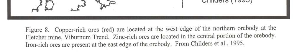
2 crystals defined the outer margins of the runs. In an effort to further use galena crystal habit as a means of defining ore fluid flow in the Viburnum Trend, Sun et al. 16 carefully measured the degree of cubic modification of 400 octahedral galena crystals from 103 locations in the Sweetwater mine. The galena crystals were classified into ten groups of varying octahedron:cube development. The locations of the ten types outlined linear northwest and northeast trends with increasingly greater cubic modification as the fluids flowed along the fracture channels and moved laterally from the source channels. DIRECTIONS OF ORE FLUID MOVEMENT INTERPRETED FROM OREBODY POSITIONS RELATIVE TO PRECAMBRIAN TOPOGRAPHY AND METAL ZONING PATTERNS For the purposes of the present study of possible directions of ore fluid movement, eight areas in the Southeast Missouri Lead District were considered with respect to the positions of orebodies with respect to Precambrian ridges and knobs and with respect to areal mineral/metal zoning patterns. Where the ore fluids had a considerable horizontal component and were impeded by structures in the paths of their movement, the ore fluids may be deflected around those impediments and provide a clue to the directions of their movements. In the Southeast Missouri Lead District this relationship is most readily observed where the ore fluids have been impeded and deflected around Precambrian knobs and ridges. Areal patterns of mineral and/or metal zoning can also reveal directions of movement of the ore fluids that deposited those minerals. Early deposited copper-rich ores were deposited closer to the source than the later deposited lead and zinc sulfides. Even later deposited sulfides typically were deposited further from the source. In the Southeast Missouri Lead District, copper-rich chalcopyrite ores mark the portion of the orebody toward the direction from which the ore fluids came, whereas iron-rich marcasite and pyrite ores mark the portion of the orebody furthest from the source. The application of these principles to eight selected areas provide some interesting insight into potential directions of ore fluid movements in the district. Viburnum 27 Mine, Viburnum Trend The relationship between ore deposit distribution and Precambrian ridges is especially well shown at the Viburnum 27 mine in the Viburnum Trend. 17 Two relatively high Precambrian ridges, which are about 2000 feet long and arranged crudely in an east-west direction, have served to constrain the southwestward flow of the ore fluids. The ore deposit was deposited on the north and west sides of the two ridges. The deposit also extends to southward where the ore fluids passed between the two ridges (Fig. 1). These spatial relationships indicates that the ore fluids at the Viburnum 27 mine were flowing in a south to southeast direction. Exploration in the Palmer Area, Northwest of the Viburnum Trend A second area in which spatial relationships between lead-zinc mineralization and a Precambrian ridge provide evidence for the direction of ore fluid movement is that of an area of exploration by the Doe Run Company in the Palmer area to the north-northwest of the Viburnum Trend. 18 Where a lead-zinc mineralized trend from the westnorthwest was impeded by a northeast-trending Precambrian ridge, the mineralization was deflected around each end of the Precambrian ridge (Fig. 2). It appears that east-southeast-flowing ore fluids were initially ponded against the ridge and then they flowed southeastward around each end of the ridge. Casteel mine, Viburnum Trend At the Casteel mine in the Viburnum Trend, part of the orebody extends westward from the main north-south trend of the Viburnum Trend. In order to closely compare the position of the orebody at Casteel with the Precambrian and structural relief, figures 2 and 3 from Dunn and Grundmann 19 have been changed to the same scale and superimposed (Fig. 3). The extension of the orebody to the west, as pointed out by Dunn and Grundmann, follows the crest of an underlying Precambrian ridge. Where the westward extension reached a high Precambrian knob, the ore fluids flow both to the north and to the west partially encircling the knob. These relationships appear to indicate that some of the ore fluids at the Casteel mine escaped from the main north-south trend and traveled westward along the ridge crest. Where the westward-traveling fluids were impeded by the high knob and forced to flow northward along the east side of the knob and westward along the south side of that knob. Indian Creek Subdistrict The Indian Creek subdistrict consisted of two mines that were operated in an area located to the northeast of the Viburnum Trend and northwest of the Old Lead Belt. The ore deposits occurred in close association with a northeast-trending Precambrian ridge. The ores were predominantly in the uppermost part of the Lamotte Formation, but they extended upward into the lowest Bonneterre Formation. Figure 4 is a modification of a block diagram from Kyle and Gutierrez, 20 but in which the orebodies have been projected back down upon the Precambrian topography and rotated to place north at the top. The main long orebody occurs along the west-northwest side of a Precambrian knob and the smaller orebody occurs at the northnortheast end of that ridge. These relationships appear to indicate that the ore fluids at Indian Creek have come from the west-northwest and ponded against the northwest side of the Precambrian ridge. With respect to ore mineral zoning, the long orebody is copperrich at each end of that orebody. This probably indicates that the ore fluids entered this orebody at each end and then spread through the orebody. The position of the copper-rich ores within the smaller orebody provide further support for the ore fluid movements from the west-northwest. Old Leadbelt Subdistrict Metal zoning was studied in the Old Lead Belt Subdistrict by Davis. 21 The main area of copper-rich ores occurred along the northeast side of the northwest-trending subdistrict, but a smaller area of copper-rich ores were present at the northwest end of that subdistrict (Fig. 5). The distributions of copper-rich ores in this subdistrict is interpreted here to indicate that ore fluids came from the northeast along the northeast side of the subdistrict, but that ore fluids also came from the northwest along the northwest end of the subdistrict. The fact that the ores were said to be concentrated on the northwest side of some of the sedimentary structures at the northwest end of the subdistrict, 22 lends support to this interpretation of the metal zoning pattern. Hayden Creek mine, Old Leadbelt Subdistrict Further support for ore fluid movement from the northwest in the northwest portion of the Old Leadbelt Subdistrict comes from the fact that the Lamotte conglomerate-hosted orebodies at the Hayden Creek mine were positioned along the northwest and west-northwest sides of two Precambrian granite knobs. 23 Short extensions of the ore to the south and southeast from the two knobs occurred where the fluids flowed around those two knobs (Fig. 6). Fletcher mine, South Orebody, Viburnum Trend The pattern of metal zoning in the southern orebody at the Fletcher mine has been mapped by Childers et al. 24 and is shown in Figure 7. Where copper-rich ores are present they occur along the western side of the orebody. Relatively zinc-rich ores overlap the copper ores on the west and are present in the center of the orebody. This areal distribution suggests that the fluid came from the west depositing early copper-rich ores, and subsequently depositing somewhat later zinc-rich ores. Fletcher mine, North Orebody, Viburnum Trend The pattern of metal zoning in the northern orebody at the Fletcher mine also has been mapped by Childers et al. 24 and is shown in Figure 8. The copper-rich ores are predominantly along the western edge of the orebody, but a smaller area of copper-rich ores also occurs locally on the east. Again, relatively zinc-rich ores overlap the copper ores on the west and are present in the center of the orebody. Ironrich ores occur along the eastern side throughout the length of the mapped orebody. It is interpreted that ore fluids moving from the west deposited copper-rich ores on the west, later zinc-rich ores in the middle, and late iron-rich ores on the east. 2 Copyright 2006 by SME
3 West Fork mine, Viburnum Trend The pattern of metal zoning at the West Fork mine is similar to that at the Fletcher mine and may represent the dominant pattern for most ore deposits in the Viburnum Trend. Figure 9 is from Childers et al. 24 and it is a simplification of a map from Mavrogenes et al. 25 The copper-rich ores are restricted to the west edge of the orebody, and this suggests that the ore fluids at West Fork (and Fletcher) came from the west. Support for this interpretation comes from the fact that the late iron-rich pyrite-marcasite ores are concentrated along the east edge of that orebody. Magmont-West mine, Viburnum Trend The Magmont-West mine is an unusual orebody that lies about two miles west of the main Viburnum Trend, occurs slightly higher stratigraphically than most orebodies in the trend, contains relatively zinc-rich ores, and is interpreted to be closely controlled by a northwest-trending fault or fracture zone. 26,27 The form of the orebody also is partly modified by control from two minor east-northeasttrending faults (Fig. 10). Copper-rich ores occur at the east-northeast edge of the orebody and indicate that at Magmont-West the ore fluids came from the east-northeast (from the main Viburnum Trend to the east). In contrast to the map by Fennel, however, Voss 28 noted that there were rich copper ores along the west edge of Magmont-West orebody during the final days of mining, a feature that would suggest a component of ore fluid movement also from the west. A small area of copper-nickel sulfide ores formed even earlier than the copper-rich ores, and their location was closely associated with the intersections of the main northwest-trending fault with one of the minor northeast-trending faults. SUMMARY AND CONCLUSIONS One of the most interesting and controversial aspects of the ore deposits of southeast Missouri is that of the directions of flow of the ore fluids. One would presume that for the 45 mile-long north-south Viburnum Trend the answer would be simple. Either the fluids entered the trend from the south and flowed north, or the fluids entered the trend from north and flowed south. Previous workers have usually ascribed to one or the other of these thoughts. The present study has utilized the ponding of ore fluids behind Precambrian ridges and knobs and the patterns of ore mineral zoning to interpret the patterns of ore fluid flow in the district. The interpretations of ore fluid flow for the above ten selected mines and exploration areas are shown by seven arrows on a map (Figure 11) of the Southeast Missouri Lead District modified after Guilbert and Park 29 after Kisvarsanyi. 30 Ore fluids that deposited the main orebodies in the Viburnum Trend came predominantly from the northwest. Toward the southern portion of the Viburnum Trend the fluids may have come from a more easterly direction. Ore fluids that deposited the orebodies in the Indian Creek subdistrict also came from the northwest. The ore fluids that mineralized the Old Leadbelt Subdistrict came from the northeast as well as from the northwest. Locally, the ore fluids flowed in other directions. In the Viburnum Trend, for example, the ore fluids flowed westward at the Casteel and Magmont-West mines. At those mines, it is interpreted that the ore fluids had escaped from the main Viburnum Trend and locally flowed westward. Arrows are not shown on Figure 11 for those local variations of ore fluid flow. ACKNOWLEDGEMENTS The writer wishes to acknowledge previous discussions of Southeast Missouri Lead District geology with many company geologists, and especially with Joe Wagner with respect to possible directions of ore fluid movement in the Viburnum Trend. REFERENCES 1. Hagni, Richard D. (2000), The Mineralogy of Minor and Trace Elements in the Co-Ni-Cu-Pb-Zn Ores of the Viburnum Trend, Southeast Missouri: Ag, Cd, Ge, Ga, Co, Ni, As, Sb, Bi Minerals, in Minor Elements 2000: Processing and Environmental Aspects of As, Sb, Se, Te, and Bi, C. Young, ed., Littleton, CO, Society for Mining, Metallurgy, and Exploration, p Leach, David L. and, E. Lanier Rowan (1986), Genetic Link between Ouachita Foldbelt Tectonism and Mississippi Valley-type Deposits of the Ozarks, Geology, v. 14, p Bethke, C. M., W. J. Harrison, C. Upson,, S. P. Altaner (1988) Supercomputer Analysis of Sedimentary Basins, Science, v. 239, p Garven, Grant and J. P. Raffensperger (1997) Hydrogeology and Geochemistry of Ore Genesis in Sedimentary Basins Chapter 4 in Geochemistry of Hydrothermal Ore Deposits, Hughes L. Barnes, ed., 3 rd ed, New York, NY, John Wiley & Sons, p Shelton, Kevin L., I. B. Burstein,, Jay M. Gregg, and Richard D. Hagni, (1993), The Absence of a Regional Thermal Gradient, Does the Viburnum Trend Fit into a Common Regional Hydrologic Flow Model with other Ozark Region MVT Deposits? in Geology and Geochemistry of Mississippi Valley-type Ore Deposits, Kevin L. Shelton and Richard D. Hagni, eds University of Missouri-Rolla, Rolla, MO, p Stoiber, Richard E. (1946) Movement of Mineralizing Solutions in the Picher Field, Oklahoma-Kansas, Econ. Geol., v. 41, p Fass, Fred W. R. (1980), Mineral Asymmetry and Direction of Flow of the Ore-forming Fluids in the Viburnum Trend, Southeast Missouri, Unpub. M.S. Thesis, Univ. Missouri-Rolla, Rolla, Missouri, 94 p. 8. Hagni, Richard D. (1983), Ore Microscopy, Paragenetic Sequence, Trace Element Content, and Fluid Inclusion Studies of the Copper- Lead-Zinc Deposits of the Southeast Missouri Lead District, in International Conference on Mississippi Valley Type Lead-Zinc Deposits, Proceedings Volume, Geza Kisvarsanyi, S. Kerry Grant, Waldemar P. Pratt, and John W. Koenig, eds., University of MO- Rolla, Rolla, MO, p Jessey, David R. (1981), Mineralogical and Compositional Variations of the Nickel-Cobalt Mineralization in the S.E. Missouri Mining District, in Process Mineralogy, Donald M. Hausen and Won C. Park, eds., AIME, New York, p Hagni, Richard D. (1983), Minor Elements in Mississippi Valleytype Ore Deposits," Chapter 7 in, Cameron Volume on Unconventional Mineral Deposits, Wayne C. Shanks, III, ed. SME- AIME, New York, p Horrall, Keneth B., Mark R. Farr, and Richard D. Hagni (1997), Evidence for Focusing of Mississippi Valley-type fluids along the Bloomfield Lineament Zone, southeast Missouri, in. Carbonate- Hosted Lead-Zinc Deposits, Donald F. Sangster, ed,75 th Anniversary Volume, Soc. Econ. Geol. Spec. Publ. No. 4, p Gregg, Jay M. and Kevin L. Shelton (1989), Minor- and Traceelement Distributions in the Bonneterre Dolomite (Cambrian), Southeast Missouri: Evidence for Possible Multiple-Basin Fluid Sources and Pathways during Lead-Zinc Mineralization, Geological Society of America Bulletin, v. 101, p Wagner, R. Joe (1973), Stratigraphic and Structural Controls and Genesis of Barite Deposits in Washington County, Missouri, Unpub. Ph.D. Dissertation, University of Michigan, Ann Arbor, Michigan, 265 p. 14. Wagner, R. Joe (1995), Stratigraphic and Structural Controls and Genesis of Barite Deposits in Washington County, Missouri, (abstract and 2 figures) in Carbonate-Hosted Lead-Zinc-Fluorite- Barite Deposits of North America, Kula C. Misra,, ed., Society of Economic Geologists, International Field Conference Guidebook, p Morris, Richard L. (1994), Sulfide Minerals and Galena Morphological Distributions in Selected Viburnum Trend Ore Deposits, Southeast Missouri, Unpub. M.S. Thesis, University of Missouri-Rolla, Rolla, Missouri, 133 p. 16. Sun, Yan, Richard D. Hagni, Wayne T. Walker, and R. Joe Wagner (1998), Classification and Areal Distributions of Galena Morphologies in a Mississippi Valley-type Deposit, Sweetwater mine, Viburnum Trend, Southeast Missouri, U.S.A., in Proceedings of the Ninth IAGOD Symposium, International Association on the Genesis of Ore Deposits, Beijing, China, Richard D. Hagni, ed., E. 3 Copyright 2006 by SME
4 Schweizerbart'sche Verlagsbuchhandlung, Stuttgart, Germany, p Grundmann, William H., Jr. (1977), Geology of the Viburnum No. 27 mine, Viburnum Trend, Southeast Missouri, Econ. Geol., v. 72, p Wagner, R. Joe (2002), pers. comm Dunn, Robert G., Jr. and William H. Grundmann, Jr., (1989), Geology of the Casteel Mine: Copper-rich Ore in a MVT Setting, in Mississippi Valley-type Mineralization of the Viburnum Trend, Missouri, Richard D. Hagni and Raymond M. Coveney, Jr., eds., Society of Economic Geologists Guidebook Series, v. 5, p Kyle, J. Richard and G. N. Gutierrez (1988), Origin of the Indian Creek Sandstone-hosted Lead Deposits, Southeast Missouri, USA, Proceedings of the 7 th Quadrennial IAGOD Symposium, Lulea, Sweden, p Davis, James H. (1960), Mineralization in the Southeast Missouri Lead district, Unpub. Ph.D. Dissertation, Univ. Wisconsin, 68 p. 22. Perry, Bobbie (1961), pers. comm Ohle, Ernest L. (1952), Geology of the Hayden Creek Lead Mine, Southeast Missouri, AIME Trans., v. 193, p Childers, G. Andrew, Norman L. Paarlberg, and Lanny L. Evans (1995), Geology of the Fletcher Mine, Viburnum Trend, Southeast Missouri, in Carbonate-Hosted Lead-Zinc-Fluorite-Barite Deposits of North America, Kula C. Misra,, ed., Society of Economic Geologists, International Field Conference Guidebook, p Mavrogenes, John A., Richard D. Hagni, and P. Richard Dingess (1992), Metal Sulfide Mineral Zoning at ASARCO's West Fork Mine, Viburnum Trend, Southeast Missouri, Econ. Geol, v. 87, p Bradley, Milton F. and Thomas E. Krolak (1989), Magmont-West Lead-Zinc-Copper Mine (Cominco American Incorporated-Dresser Minerals) Viburnum Trend, Southeast Missouri, in Mississippi Valley-type Mineralization of the Viburnum Trend, Missouri, Richard D. Hagni and Raymond M. Coveney, Jr., eds., Society of Economic Geologists Guidebook Series, v. 5, p Fennel, Mark J., Richard D. Hagni, and Milton F. Bradley (1997), Mineralogy, Paragenetic Sequence, and Mineral Zoning at the Magmont-West Mine, Viburnum Trend, Southeast Missouri Lead District, in Carbonate-Hosted Lead-Zinc Deposits, Donald F. Sangster, ed., 75th Anniversary Volume, Society of Economic Geologists, p Voss, Robert L. (2003), pers. comm Guilbert, John M. and Charles C. Park (1999), The Geology of Ore Deposits, New York, NY, W. H. Freeman, 7 th printing, 985 p. 30. Kisvarsanyi, Geza (1977), The Role of the Precambrian Igneous Basement in the Formation of the Stratabound Lead-Zinc-Copper Deposits in Southeast Missouri, Econ. Geol., v. 72, p Copyright 2006 by SME


5 5 Copyright 2006 by SME


6 6 Copyright 2006 by SME


7 7 Copyright 2006 by SME


8 8 Copyright 2006 by SME


9 9 Copyright 2006 by SME


10 10 Copyright 2006 by SME


11 11 Copyright 2006 by SME


12 12 Copyright 2006 by SME
13 13 Copyright 2006 by SME


14 14 Copyright 2006 by SME


15 15 Copyright 2006 by SME
Geology of the RC Westfork Cemetery Ridge Solution Collapse Breccia, Viburnum Trend, Southeast Missouri. By Thomas Schott
 Geology of the RC Westfork Cemetery Ridge Solution Collapse Breccia, Viburnum Trend, Southeast Missouri By Thomas Schott Introduction Viburnum Trend Pb-Zn mineralization is blind Historically poor results
A fluid inclusion study of the drusy quartz of the Potosi Dolostone, Southeast Missouri.
 Water-Rock Interactions, Ore Deposits, and Environmental Geochemistry: A Tribute to David A. Crerar The Geochemical Society, Special Publication No.7, 22 Editors: Roland Hellmann and Scott A. Wood A fluid
Reactive Flow Models of Ore Formation in the Southeast Missouri District
 Economic Geology Vol. 95, 0, pp. 1605 1626 Reactive Flow Models of Ore Formation in the Southeast Missouri District MARTIN S. APPOLD, * AND GRANT GARVEN Department of Earth and Planetary Sciences, Johns
Geol. 656 Isotope Geochemistry
 HYDROTHERMAL ACTIVITY, METAMORPHISM, AND ORE DEPOSITS II SULFUR ISOTOPE FRACTIONATION IN LOW-TEMPERATURE SYSTEMS 2 - At temperatures below about 400 C, sulfate (SO 4 ) species becomes the dominant form
AUTHIGENIC KAOLINITE AND DICKITE ASSOCIATED WITH METAL SULFIDES--PROBABLE INDICATORS OF A REGIONAL THERMAL EVENT
 Clays and Clay Minerals, Vol. 36, No. 2, 153-158, 1988. AUTHIGENIC KAOLINITE AND DICKITE ASSOCIATED WITH METAL SULFIDES--PROBABLE INDICATORS OF A REGIONAL THERMAL EVENT W. D. KELLER Geology Department,
Fracture, Fluid Flow and Diagenetic History of the Arbuckle Group
 Fracture, Fluid Flow and Diagenetic History of the Arbuckle Group Robert H. Goldstein, Evan K. Franseen, W. Lynn Watney, Bradley King STATUS: Focused-term near completion, year 3 of 3 TIMING: Began August
Mississippi Valley-Type Lead-Zinc Deposit Model
 Mississippi Valley-Type Lead-Zinc Deposit Model By David L. Leach and Ryan D. Taylor Open-File Report 2009 1213 U.S. Department of the Interior U.S. Geological Survey U.S. Department of the Interior KEN
USGS: USGS: NEIC NEIC
 Triggered Earthquakes in North-Central Arkansas and their Relationship to Class II UIC Wells Scott M. Ausbrooks, The Arkansas Geological Survey Steve Horton, Ph.D., CERI at University i of Memphis Contributors:
Geology 12 FINAL EXAM PREP. Possible Written Response Exam Questions
 Geology 12 FINAL EXAM PREP Possible Written Response Exam Questions Use this study guide to prepare for the written response portion of the final exam. Name FINAL EXAM - POSSIBLE WRITTEN RESPONSE QUESTIONS
GSA DATA REPOSITORY Appendix DR1: Sample Descriptions
 GSA DATA REPOSITORY 2015055 Appendix DR1: Sample Descriptions 8S08FW This sample of massive pyrite was collected by Jamie Wilkinson from the southern part of the Lisheen Main Zone orebody (Panel 8, Stope
POTENTIAL FOR SIGNIFICANT UNDISCOVERED METALLIC ORE DEPOSITS IN MAINE. John F. Slack U.S. Geological Survey (Emeritus), Farmington, ME 04938
, Farmington, ME 04938") POTENTIAL FOR SIGNIFICANT UNDISCOVERED METALLIC ORE DEPOSITS IN MAINE John F. Slack U.S. Geological Survey (Emeritus), Farmington, ME 098 Geological Society of Maine, Augusta, 7 November 207 Outline Important
POTENTIAL FOR SIGNIFICANT UNDISCOVERED METALLIC ORE DEPOSITS IN MAINE John F. Slack U.S. Geological Survey (Emeritus), Farmington, ME 098 Geological Society of Maine, Augusta, 7 November 207 Outline Important
CSA Mine Observations Applied to the Development of Regional Exploration Models
 CSA Mine Observations Applied to the Development of Regional Exploration Models 1 Introduction Recent work completed by the geology team has resulted in an improved understanding of the CSA mine system
SECOND DRILL HOLE IHAD2 INTERSECTS MINERALIZED TAPLEY HILL FORMATION AND MINERALIZED BASEMENT IRON FORMATION
 Suite 304, 22 St Kilda Road St Kilda Vic 3182 Ph: +61 3 9692 7222; Fax: +61 3 9529 8057 For Immediate Release 14 th September 2007 SECOND DRILL HOLE IHAD2 INTERSECTS MINERALIZED TAPLEY HILL FORMATION AND
Climax and Henderson Porphyry Molybdenum Deposits and The Leadville District, Colorado
 GUIDEBOOK SERIES Volume 43 Climax and Henderson Porphyry Molybdenum Deposits and The Leadville District, Colorado Prepared for the Society of Economic Geologists Field Trip September 25-27, 2014 Field
The Occurrences of Base Metal Mineralization in Cikadu-Cisungsang Area, Banten Province, Indonesia*)
") The Occurrences of Base Metal Mineralization in Cikadu-Cisungsang Area, Banten Province, Indonesia*) Rosana, M.F., Haryanto, A.D., Yuniardi, Y., Yuningsih, E.T. Department of Geology, Padjadjaran University
The Occurrences of Base Metal Mineralization in Cikadu-Cisungsang Area, Banten Province, Indonesia*) Rosana, M.F., Haryanto, A.D., Yuniardi, Y., Yuningsih, E.T. Department of Geology, Padjadjaran University
Minor elements in some rocks and minerals of the Rakha mines area, Singhbhum, India
 671 Minor elements in some rocks and minerals of the Rakha mines area, Singhbhum, India By S. B. BHATTACHERJEE, A. K. GHOSH, 1 Mrs. L. BHATTACHERJEE, 2 and SANTI BHATTACHERJEE Physics Department, University
Drill locations for the 2015 program are highlighted in the geology map below.
 2015 Exploration Program The exploration program plan at KSM for 2015 was designed to improve the understanding of block cave targets and support engineering/environmental aspects of development scenarios.
Web Supplement
 Web Supplement 19.4.6 Economic Deposits including Ores Some of the mounds of metalliferous sediment contain enough metals in high concentrations to be of economic interest. For example, the TAG (Trans-Atlantic
Structural Styles and Geotectonic Elements in Northwestern Mississippi: Interpreted from Gravity, Magnetic, and Proprietary 2D Seismic Data
 Structural Styles and Geotectonic Elements in Northwestern Mississippi: Interpreted from Gravity, Magnetic, and Proprietary 2D Seismic Data Nick Loundagin 1 and Gary L. Kinsland 2 1 6573 W. Euclid Pl.,
New Deep Inferred Resources at Tara Mine
 New Deep Inferred Resources at Tara Mine Summary Deep drilling, over the period 2012-2016, on a seismic exploration target south of the Tara Mine, has intersected a new zone of Zn-Pb mineralisation with
Wind Mountain Project Summary Memo Feeder Program
 A Manex Resource Group Company Wind Mountain Project Summary Memo Feeder Program J.A. Kizis, Jr., February 07, 2018 Assays have been received for both holes drilled at Wind Mountain during late 2017 and
General Geologic Setting and Seismicity of the FHWA Project Site in the New Madrid Seismic Zone
 General Geologic Setting and Seismicity of the FHWA Project Site in the New Madrid Seismic Zone David Hoffman University of Missouri Rolla Natural Hazards Mitigation Institute Civil, Architectural & Environmental
VECTORING VOLCANOGENIC MASSIVE SULPHIDE MINERALIZATION AT THE RAINDROP ZONE, SNOW LAKE (NTS 63K16), MANITOBA by G.H. Gale
, MANITOBA by G.H. Gale") GS-8 VECTORING VOLCANOGENIC MASSIVE SULPHIDE MINERALIZATION AT THE RAINDROP ZONE, SNOW LAKE (NTS 63K16), MANITOBA by G.H. Gale Gale, G.H. 2002: Vectoring volcanogenic massive sulphide mineralization at
GS-8 VECTORING VOLCANOGENIC MASSIVE SULPHIDE MINERALIZATION AT THE RAINDROP ZONE, SNOW LAKE (NTS 63K16), MANITOBA by G.H. Gale Gale, G.H. 2002: Vectoring volcanogenic massive sulphide mineralization at
PRIMARY NATIVE SILVER ORES AT BATOPILAS, MEXICO, AND BULLARD'S PEAK, NEW MEXICO
 PRIMARY NATIVE SILVER ORES AT BATOPILAS, MEXICO, AND BULLARD'S PEAK, NEW MEXICO PHILIP KRIEGER, Columbia University, New York City. INTRODUCTION Many of the silver deposits on which there is seemingly
12 tons of high-grade ore was mined from the No. 1 vein with an average grade of 13 g/t gold, 3,250 g/t silver and 23.3% lead.
 DUNWELL MINE GROUP The Dunwell Mine Group (Dunwell, Dunwell East, Bear River/MM and Silvershot properties), which includes the historic, past-producing Dunwell mine, is located 8 km northeast of Stewart
Trace and minor elements in. sphalerite: an assessment of. distributions in metamorphosed. deposits:
 Trace and minor elements in sphalerite: an assessment of distributions in metamorphosed deposits: Thesis submitted in accordance with the requirements of the University of Adelaide for an Honours Degree
Geochemical exploration on the Tareek Darreh Gold deposit, north of Torbat-e Jaam, east Iran
 Geochemical exploration on the Tareek Darreh Gold deposit, north of Torbat-e Jaam, east Iran Kourosh Shabani, M.Sc. Student of Economic Geology, Islamic Azad University, Science and Research Branch, Tehran,
POTENTIAL OF THE DONGWE COPPER GOLD PROJECT
 POTENTIAL OF THE DONGWE COPPER GOLD PROJECT By Nathan Sabao, P.Geo. September 2015 1 TABLE OF CONTENTS Page 1.0 EXECUTIVE SUMMARY 1 2.0 LOCATION 2 3.0 ACCESS 2 4.0 GEOLOGY 3 5.0 PREVIOUS DRILLING 5 6.0
Determining the Direction of Ice Advance Forming the Roanoke Point Moraine From a Survey of Hartford Basin Erratics
 Determining the Direction of Ice Advance Forming the Roanoke Point Moraine From a Survey of Hartford Basin Erratics J Bret Bennington 1 and Tim Young 2 1 Department of Geology, 114 Hofstra University,
The Geology of ORE DEPOSITS. John M. Guilbert. University of Arizona. Charles F. Park, Jr. W. H. Freeman and Company / New York
 The Geology of ORE DEPOSITS John M. Guilbert University of Arizona Charles F. Park, Jr. W. H. Freeman and Company / New York Contents Preface xii Introduction 1 Mineral Resource Problems 4 The Role of
* **
 MT. BULGA REVISITED Bob Whiteley* and Tak Ming Leung** * rjwhiteley@optusnet.com.au ** tak-ming_leung@rta.nsw.gov.au Mt Bulga is located near Orange, New South Wales some 260 km west of Sydney. The first
An investigation of lead and other metal contaminants in the sediments of Clearwater Lake, Missouri
 Scholars' Mine Doctoral Dissertations Student Theses and Dissertations Fall 2007 An investigation of lead and other metal contaminants in the sediments of Clearwater Lake, Missouri Gary W. Krizanich Follow
Figure 1: Location of principal shallow conductors at Alpala (anomalies C0-C10; 5 Ohm/m surfaces, red) and shallow zones of electrical chargeability
 and shallow zones of electrical chargeability") Figure 1: Location of principal shallow conductors at Alpala (anomalies C0-C10; 5 Ohm/m surfaces, red) and shallow zones of electrical chargeability (85 msecs, yellow-green) shown on iso-surfaces of MVI
Figure 1: Location of principal shallow conductors at Alpala (anomalies C0-C10; 5 Ohm/m surfaces, red) and shallow zones of electrical chargeability (85 msecs, yellow-green) shown on iso-surfaces of MVI
Calcite Cements in Middle Devonian Dunedin Formation:
 Geochemistry of the Fracture-Filling Dolomite and Calcite Cements in Middle Devonian Dunedin Formation: Implication for the Strata Dolomitization Model Sze-Shan Yip 1, Hairuo Qing 1 and Osman Salad Hersi
ORE MICROSCOPY AND ORE PETROGRAPHY
 >...- ORE MICROSCOPY AND ORE PETROGRAPHY Second Edition JAMES R. CRAIG Department of Geological Sciences Virginia Polytechnic Institute and State University Blacksburg, Virginia DAVID J. VAUGHAN Department
Groundwater Resources of Missouri. Cynthia Brookshire, R. G.
 Groundwater Resources of Missouri Cynthia Brookshire, R. G. GROUNDWATER... Water beneath the Earth s surface within a zone of saturation AQUIFER... A geologic formation or group of formations that are
Potential for Nickel- Copper Sulphide
 2 Potential for Nickel- Copper Sulphide mineralisation in the Giles Complex Thesis submitted in accordance with the requirements of the University of Adelaide for an Honours Degree in Geology Anna Victoria
The MAPLE BAY PROJECT Copper Silver - Gold
 The MAPLE BAY PROJECT Copper Silver - Gold Good grade and tonnage potential within close proximity to Tidewater The Maple Bay Copper Silver Gold Project covers highly favourable geological host rocks of
UNDERSTANDING MINERAL DEPOSITS
 UNDERSTANDING MINERAL DEPOSITS U nderstanding Mineral Deposits by Kula c. Misra Department of Geological Sciences, The University oftennessee, Knoxville, U.S.A. SPRINGER-SCIENCE+BUSINESS MEDIA, B.V. A
core samples and soil focusing on geochemistry and gold-sulphide paragenesis (Gunn et al.,
 CHAPTER 1 INTRODUCTION 1.0 Introduction Penjom Gold Mine (PGM) is the biggest gold mine in Malaysia and has produced more than 45 tonnes (1.4 Moz) of gold since 1997. As in 2014, Penjom still has resources
Petrology and Alteration of Lari Mountain in Arinem Area, West Java, Indonesia
 Petrology and Alteration of Lari Mountain in Arinem Area, West Java, Indonesia Fatoni Adyahya 1 *, Euis T. Yuningsih 1, Ildrem Syafrie 1, H. Matsueda 2, A. Hardiyono 1 1 Faculty of Geology, University
Central West Greenland. 2. Lead
 Locality/Name: Region: Longitude: Latitude: Commodities: Economic significance: Maarmorillik, Black Angel Central West Greenland 51 15'9.2''W 71 9'14.6''N 1. Zinc 2. Lead Mine, closed Geological setting:
LONG LAKE ZINC MINE. Selected References "Zinc and Lead Deposits of Canada'% Geol. Surv. Can., Econ. Geol. Series, No k 8, 1930, pp, H6-151.
 April,1952 31CI8NW8eie 63.3149 OLDEN 010 ^ LONG LAKE ZINC MINE Selected References Alcock, P.J., "Zinc and Lead Deposits of Canada'% Geol. Surv. Can., Econ. Geol. Series, No k 8, 1930, pp, H6-151. Harding,
Chapter 8 10/19/2012. Introduction. Metamorphism. and Metamorphic Rocks. Introduction. Introduction. The Agents of Metamorphism
 Chapter 8 Metamorphism Introduction Metamorphism - The transformation of rocks, usually beneath Earth's surface, as the result of heat, pressure, and/or fluid activity, produces metamorphic rocks During
EXISTING GEOLOGICAL INFORMATION
 CHAPER 3 EXISTING GEOLOGICAL INFORMATION 3-1 General Geology of the Surrounding Area (1) General geology and ore deposits in Mongolia Geographically, Mongolia is a country located between Russia to the
Petrological Studies by Terry Leach at the North Carlin Trend, Nevada. Keith Bettles October 17, 2008
 Petrological Studies by Terry Leach at the North Carlin Trend, Nevada Keith Bettles October 17, 2008 North Carlin Trend From 1999 to 2003 Terry Leach studied the Betze and Meikle ore bodies for Barrick
UNICORN MINERAL RESOURCES LIMITED
 UNICORN MINERAL RESOURCES LIMITED IRISH MIDLANDS OREFIELD COPPER / LEAD / ZINC and SILVER EXPLORATION PROJECTS WWW.UNICORNMINERALRESOURCES.COM 1 Forward Looking Statements Disclaimer Certain information
NOA ASSESSMENT HARRIS QUARRY MENDOCINO COUNTY, CALIFORNIA TABLE OF CONTENTS
 NOA ASSESSMENT HARRIS QUARRY MENDOCINO COUNTY, CALIFORNIA TABLE OF CONTENTS Introduction... 1 Scope of Services... 1 Project Location and Description... 1 Geologic Setting... 1 Regional Geology... 1 Site
A Geological Tour of Tumbledown Mountain, Maine
 Maine Geologic Facts and Localities April, 1998 A Geological Tour of Tumbledown Mountain, Maine 44 45 3.21 N, 70 32 50.24 W Text by Robert G. Marvinney, Department of Agriculture, Conservation & Forestry
ASX RELEASE. Punt Hill Project Update
 Exploration Office Unit 2, 81 Harrison Road Dudley Park SA 5008 ABN: 96 110 336 733 Tel: +61 8 8245 4900 Fax: +61 8 8245 4999 www.monaxmining.com.au For Immediate Release Monday 15 June, 2015 ASX RELEASE
The Aïn Kerma Gold Prospect (ONHYM) Tan Tan Province, Guelmin - Es Semara Region, Southern Morocco. Field Visit Report
 Tan Tan Province, Guelmin - Es Semara Region, Southern Morocco. Field Visit Report") The Aïn Kerma Gold Prospect (ONHYM) Tan Tan Province, Guelmin - Es Semara Region, Southern Morocco. Field Visit Report 1. Introduction The field visit took place on Wednesday, the 21 st July. It took place
The Aïn Kerma Gold Prospect (ONHYM) Tan Tan Province, Guelmin - Es Semara Region, Southern Morocco. Field Visit Report 1. Introduction The field visit took place on Wednesday, the 21 st July. It took place
FIRST YEAR ASSESSMENT REPORT PROSPECTING LICENCE 16512M MARYSTOWN AREA, BURIN PENINSULA NTS 1M/3
 FIRST YEAR ASSESSMENT REPORT OF PROSPECTING ON LICENCE 16512M MARYSTOWN AREA, BURIN PENINSULA NTS 1M/3 BY NATHANIEL NOEL MSc. FOR E. MICHELE NOEL MINERAL LICENCES: 16512 M WORK CONDUCTED: MID-SEPTEMBER
EXPLORATION LICENCE SURROUNDING THE HISTORIC FALUN COPPER MINE GRANTED
 ASX ANNOUNCEMENT 30 August 2007 EXPLORATION LICENCE SURROUNDING THE HISTORIC FALUN COPPER MINE GRANTED The Drake-Zinifex Alliance application for an exploration licence that covers the historic Falun copper
Geologic History of Texas: The Making of Texas Over 1.5 Billion Years
 # 4 Geologic History of Texas: The Making of Texas Over 1.5 Billion Years Dr. Richard Kyle March 24, 2000 Produced by and for Hot Science - Cool Talks by the Environmental Science Institute. We request
Maria SASS-GUSTKIEWICZ
 Bulletin de la Société géographique de Liège, 29, 1993, 87-92. Reconstruction of hydrothermal karst system in Zn-Pb sulphide deposits Upper Silesian region, Poland Maria SASS-GUSTKIEWICZ Abstract In the
About Earth Materials
 Grotzinger Jordan Understanding Earth Sixth Edition Chapter 3: EARTH MATERIALS Minerals and Rocks 2011 by W. H. Freeman and Company About Earth Materials All Earth materials are composed of atoms bound
6. In the diagram below, letters A and B represent locations near the edge of a continent.
 1. Base your answer to the following question on the cross section below and on your knowledge of Earth science. The cross section represents the distance and age of ocean-floor bedrock found on both sides
Aliabad-Morvarid iron-apatite deposit, a Kiruna type example in Iran
 Aliabad-Morvarid iron-apatite deposit, a Kiruna type example in Iran Maryam-Sadat Mazhari 1 *, Majid Ghaderi 1, Mohammad-Hassan Karimpour 2 1 Department of Geology, Tarbiat Modares University, Tehran,
For personal use only
 Suite 2501 Level 25 St Martins Tower 31 Market Street Sydney NSW 2000 Australia (PO Box Q638 QVB Market Street NSW 1230 Australia) Tel: +61 (02) 9283 3880 ASX RELEASE GMN 05 March 2018 BONANZA GRADE TYPE
Dynamic Crust Practice
 1. Base your answer to the following question on the cross section below and on your knowledge of Earth science. The cross section represents the distance and age of ocean-floor bedrock found on both sides
Geomechanical Modelling of the Mount Isa Copper Deposit
 Geomechanical Modelling of the Mount Isa Copper Deposit John G McLellan 1, 2, Rhonda O Sullivan 3, Brad Miller 4, Daniel Taylor 5 1. Principal Geoscience Consultant, GMEX, John@gmex.com.au. 2. Adjunct
IVANHOE MINES EXTENDS HUGO NORTH GEOPHYSICAL ANOMALY FOUR KILOMETRES NORTH ADDITIONAL GEOPHYSICAL TARGETS IDENTIFIED
 December 6, 2004 IVANHOE MINES EXTENDS HUGO NORTH GEOPHYSICAL ANOMALY FOUR KILOMETRES NORTH ADDITIONAL GEOPHYSICAL TARGETS IDENTIFIED ULAANBAATAR, MONGOLIA Ivanhoe Mines Chairman Robert Friedland, Deputy
Economic Ores. - Mostly metals
 Economic Ores - Mostly metals Intro points An ore is a naturally occurring solid material from which a metal or valuable mineral can be profitably extracted. Gangue is the commercially valueless material
UNICORN MINERAL RESOURCES LIMITED
 UNICORN MINERAL RESOURCES LIMITED IRISH MIDLANDS COPPER / LEAD / ZINC and SILVER EXPLORATION PROJECTS WWW.UNICORNMINERALRESOURCES.COM 1 Forward Looking Statements Disclaimer Certain information presented,
Page 1. Name:
 Name: 1) What is the approximate density of a mineral with a mass of 262.2 grams that displaces 46 cubic centimeters of water? A) 6.1 g/cm 3 C) 1.8 g/cm 3 B) 5.7 g/cm 3 D) 12.2 g/cm 3 2) In which two Earth
ROCKS & MINERALS UNIT. 8 th Grade Earth & Space Science
 ROCKS & MINERALS UNIT 8 th Grade Earth & Space Science Characteristics of Minerals 8 th Grade Earth & Space Science Class Notes Mineral Characteristics Naturally occurring formed by natural processes Inorganic
Chapter 7 Metamorphism, Metamorphic Rocks, and Hydrothermal Rocks
 Chapter 7 Metamorphism, Metamorphic Rocks, and Hydrothermal Rocks Copyright The McGraw-Hill Companies, Inc. Permission required for reproduction or display. Metamorphism What happens to rocks that are
GEOLOGY OF THE NICOLA GROUP BETWEEN MISSEZULA LAKE AND ALLISON LAKE
 GEOLOGY OF THE NICOLA GROUP BETWEEN MISSEZULA LAKE AND ALLISON LAKE (92H/15E. 10E1 By V. A. Preto INTRODUCTION Mapping was continued southward from the area covered in 1973 and an additional 55 square
'!lill[ flinii]i^,e. isfsv. 0G,c *'- SURVEY
!['!lill[ flinii]i^,e. isfsv. 0G,c *'- SURVEY](/thumbs/89/99050466.jpg "'!lill[ flinii]i^,e. isfsv. 0G,c *'- SURVEY") '!lill[ flinii]i^,e isfsv 0G,c *'- SURVEY 3 3051 00005 8770 ' ILLINOIS GEOLOGICAL SURVEY LIBRARY OCT 24 1357 r \ ILLINOIS STATE GEOLOGICAL SURVEY / i Urbana, Illinois John C. Frye, Chief \lllinois INDUSTRIAL
'!lill[ flinii]i^,e isfsv 0G,c *'- SURVEY 3 3051 00005 8770 ' ILLINOIS GEOLOGICAL SURVEY LIBRARY OCT 24 1357 r \ ILLINOIS STATE GEOLOGICAL SURVEY / i Urbana, Illinois John C. Frye, Chief \lllinois INDUSTRIAL
Sediment and sedimentary rocks Sediment
 Sediment and sedimentary rocks Sediment From sediments to sedimentary rocks (transportation, deposition, preservation and lithification) Types of sedimentary rocks (clastic, chemical and organic) Sedimentary
COAU PROPERTY LEMHI COUNTY, IDAHO
 COAU PROPERTY LEMHI COUNTY, IDAHO Utah Mineral Resources 447 N 300 W, Suite 3 Kaysville, UT 84037 (801) 544-3421 ojgatten@nae-xploration.com Prepared by: North American Mine Services, LLC. March 21, 2017
Some Geological Features at Smalls Falls, Maine
 Maine Geologic Facts and Localities July, 2005 Some Geological Features at Smalls Falls, Maine 44 51 30.47 N, 70 30 58.74 W Text by Robert Marvinney, Department of Agriculture, Conservation & Forestry
Magnus Copper Project exploration update
 ASX ANNOUNCEMENT 30 SEPTEMBER 2011 CODE: ALY BOARD OF DIRECTORS Mr Warwick Davies Non-Executive Chairman Mr Robert Brierley Managing Director Mr John Arbuckle Non-Executive Director Mr Jeffrey Moore Non-Executive
GPEX Mineral Property Portfolio. Coquihalla Gold Belt. ~ Ladner Suite ~
 GPEX Mineral Property Portfolio Coquihalla Gold Belt ~ Ladner Suite ~ GPEX s Ladner Suite consists of four properties, the Silver Salem, the Emancipation East, the Ladner Junction and West Hozameen claims.
Spatial Patterns of Mineral Deposits in the Broken Hill Region New South Wales, Australia
 Spatial Patterns of Mineral Deposits in the Broken Hill Region New South Wales, Australia PowerPoint 6-6 All images and text are Copyright 2005 by Larry Robinson Prepared as part of: The Spatial and Temporal
Figure 1.2. Growth of the world s population through history. Notice the sharp drop due to the Black Death that struck Europe in 1348, and the sharp
 Figure 1.2. Growth of the world s population through history. Notice the sharp drop due to the Black Death that struck Europe in 1348, and the sharp rise that occurred in the nineteenth and twentieth centuries.
ARGENTINE FRONTIER RESOURCES INC (AFRI) SALTA EXPLORACIONES SA (SESA)
 SALTA EXPLORACIONES SA (SESA)") ARGENTINE FRONTIER RESOURCES INC (AFRI) SALTA EXPLORACIONES SA (SESA) LA SARITA IOCG-Porphyry Copper-Gold August 2006 La Sarita Cateo 2 La Sarita - bleached center is Taca Taca Arriba. The hematite zone
ARGENTINE FRONTIER RESOURCES INC (AFRI) SALTA EXPLORACIONES SA (SESA) LA SARITA IOCG-Porphyry Copper-Gold August 2006 La Sarita Cateo 2 La Sarita - bleached center is Taca Taca Arriba. The hematite zone
454/01 GEOLOGY GL4 EXTENSION GEOLOGY. P.M. FRIDAY, 14 June (2 Hours)
") WELSH JOINT EDUCATION COMMITTEE General Certificate of Education Advanced CYD-BWYLLGOR ADDYSG CYMRU Tystysgrif Addysg Gyffredinol Uwch 454/01 GEOLOGY GL4 EXTENSION GEOLOGY P.M. FRIDAY, 14 June 2002 (2
WELSH JOINT EDUCATION COMMITTEE General Certificate of Education Advanced CYD-BWYLLGOR ADDYSG CYMRU Tystysgrif Addysg Gyffredinol Uwch 454/01 GEOLOGY GL4 EXTENSION GEOLOGY P.M. FRIDAY, 14 June 2002 (2
A) B) C) D) 4. Which diagram below best represents the pattern of magnetic orientation in the seafloor on the west (left) side of the ocean ridge?
 B) C) D) 4. Which diagram below best represents the pattern of magnetic orientation in the seafloor on the west (left) side of the ocean ridge?") 1. Crustal formation, which may cause the widening of an ocean, is most likely occurring at the boundary between the A) African Plate and the Eurasian Plate B) Pacific Plate and the Philippine Plate C)
1. Crustal formation, which may cause the widening of an ocean, is most likely occurring at the boundary between the A) African Plate and the Eurasian Plate B) Pacific Plate and the Philippine Plate C)
Report on the Ore Mineralogy of Concentrates from Footwall Zone, Ming Volcanogenic Massive Sulfide (VMS) Deposit, Baie Verte, Newfoundland
 Deposit, Baie Verte, Newfoundland") Report on the Ore Mineralogy of Concentrates from Footwall Zone, Ming Volcanogenic Massive Sulfide (VMS) Deposit, Baie Verte, Newfoundland Prepared For: Rambler Metals and Mining C/O Larry Pilgrim, BSc,
Report on the Ore Mineralogy of Concentrates from Footwall Zone, Ming Volcanogenic Massive Sulfide (VMS) Deposit, Baie Verte, Newfoundland Prepared For: Rambler Metals and Mining C/O Larry Pilgrim, BSc,
MAGMATIC-HYDROTHERMAL Cu-Au-(Mo-Pb-ZN-Ag) SYSTEMS IN THE SW-PART OF THE CARPATHO-BALKANIDES
 SYSTEMS IN THE SW-PART OF THE CARPATHO-BALKANIDES") MAGMATIC-HYDROTHERMAL Cu-Au-(Mo-Pb-ZN-Ag) SYSTEMS IN THE SW-PART OF THE CARPATHO-BALKANIDES R. JELENKOVIC 1 and T. SERAFIMOVSKI 2 1 Faculty of Mining and Geology, Djusina 7, 11000 Belgrade, FR. Yugoslavia
MAGMATIC-HYDROTHERMAL Cu-Au-(Mo-Pb-ZN-Ag) SYSTEMS IN THE SW-PART OF THE CARPATHO-BALKANIDES R. JELENKOVIC 1 and T. SERAFIMOVSKI 2 1 Faculty of Mining and Geology, Djusina 7, 11000 Belgrade, FR. Yugoslavia
Geology of Quesnel and Stikine terranes and associated porphyry deposits. Jim Logan Paul Schiarizza
 Geology of Quesnel and Stikine terranes and associated porphyry deposits Jim Logan Paul Schiarizza Quesnel and Stikine terranes Major cordilleran terranes characterized by similar Late Triassic Early Jurassic
For personal use only
 25 January 2017 HIGH GRADE ZINC, LEAD AND SILVER RESULTS UPDATE Korab Resources Ltd ( Korab, or Company ) () refers to the ASX report dated 23 November 2016 which discussed the review of historical RC
GY 111 Lecture Notes Intro to Metamorphism
 GY 111 Lecture Notes D. Haywick (2008-09) 1 Lecture Goals: A) Agents of Metamorphism B) Types of metamorphism C) Hydrothermal fluids GY 111 Lecture Notes Intro to Metamorphism Reference: Press et al.,
Update on Chillagoe Mining District Research: Dec 7, 2017
 Update on Chillagoe Mining District Research: Dec 7, 2017 Peter Illig 1, Zhaoshan Chang 1 1 EGRU James Cook University, Townsville QLD 4811, Australia Introduction to Chillagoe Deposits Regional introduction
Geochemical characteristics of gold-bearing ores of Boliden deposit, Skellefte district, Sweden
 Geochemical characteristics of gold-bearing ores of Boliden deposit, Skellefte district, Sweden Zhang, J. D. 1,2, Ishiyama, D. 1, Mizuta, T. 3, Allen, R. L. 4 and Sera, K. 5 1 Center for Geo-Environmental
Term 1 final review ES
 Name: Date: 1. t what approximate altitude in the atmosphere can stratospheric ozone be found?. 10 km. 30 km. 70 km D. 100 km 2. What percentage of Earth s history represents human existence?. less than
Native elements, sulfides, oxides, & hydroxides. JD Price
 Native elements, sulfides, oxides, & hydroxides JD Price Native Elements Gold Au Silver Ag Diamond C Graphite C Sulfur S Images from mineral.galleries.com Gold deposits Cyanide Leaching NaCN combines with
MAIN GEOCHEMICAL ASSOCIATION OF THE SULFIDES LEAD-ZINC MINERALIZATION IN TREPÇA MINERAL BELT- ARTANA MINE, KOSOVO
 MAIN GEOCHEMICAL ASSOCIATION OF THE SULFIDES LEAD-ZINC MINERALIZATION IN TREPÇA MINERAL BELT- ARTANA MINE, KOSOVO B. Durmishaj 1, S. Hyseni 1, A. Tashko 2, M. Kelmendi 1, M. Operta 3 and I.Tahiri 1 1 Faculty
A PETROGRAPHIC REPORT
 . 1 ~ A PETROGRAPHIC REPORT Prepared For: Dr. Eric Hoffman (}eneral~anager ACTIVATION LABORATORIES LTD. October 16, 2003 APR 29 2005 by: Eva S. Schandl Ph.D. GEOSC1ENCE ASSESSMENT OBJECTIVES The objectives
Mejdar Deposit Petrogenesis A Case Study of Copper Mineralization Belt in North West of Iran
 Mejdar Deposit Petrogenesis A Case Study of Copper Mineralization Belt in North West of Iran Y. Vasigh 1, R. Zamani 2 1 Corresponding author: Islamic Azad University-Ardabil branch, Basij Sq., Ardabil
Condor Blanco Mines Limited (Code: CDB) Company Presentation Devil s Creek Tenement E70/4529
 Company Presentation Devil s Creek Tenement E70/4529") Condor Blanco Mines Limited (Code: CDB) Company Presentation Devil s Creek Tenement E70/4529 Disclaimer This document is not a disclosure document nor does it constitute the provision of financial product
Condor Blanco Mines Limited (Code: CDB) Company Presentation Devil s Creek Tenement E70/4529 Disclaimer This document is not a disclosure document nor does it constitute the provision of financial product
What is a Porphyry Copper Deposit?
 What is a Porphyry Copper Deposit? by David F. Briggs Over the last several years, many of you have probably heard the term porphyry copper and wondered what everyone is talking about. Porphyry copper
Future Potential for metal Resources From Black Shales: Ni, Mo, Zn, Cu, U, V, Ag, Au, PGE
 Future Potential for metal Resources From Black Shales: Ni, Mo, Zn, Cu, U, V, Ag, Au, PGE CODES University of Tasmania Slide 9.2 Oxidized Vs Reduced Basins OXIDIZED Basins produce stratiform Cu-Co, Zn-Pb
GEOLOGIC MAPS PART II
 EARTH AND ENVIRONMENT THROUGH TIME LABORATORY - EES 1005 LABORATORY FIVE GEOLOGIC MAPS PART II Introduction Geologic maps of orogenic belts are much more complex than maps of the stable interior. Just
Mineral activities within Rich County, Utah
 Natural Resources and Environmental Issues Volume 14 Bear Lake Basin Article 10 1-1-2007 Mineral activities within Rich County, Utah Patsy Palacios SJ & Jessie E Quinney Natural Resources Research Library,
Gold Mineralization Potential in a Wabigoon Subprovince Granite-Greenstone Terrane, International Falls Area, Minnesota
 Gold Mineralization Potential in a Wabigoon Subprovince Granite-Greenstone Terrane, International Falls Area, Minnesota Manitoba Ontario Mn The State of Minnesota is located in the north-central portion
Beneath our Feet: The 4 Layers of the Earty by Kelly Hashway
 Beneath our Feet: The 4 Layers of the Earty by Kelly Hashway The Earth is more than a giant ball made up of dirt, rocks, and minerals. The Earth may look like a giant ball from when looking at it from
SQUARE POST PROJECT CHARTERS TOWERS NORTH QUEENSLAND AUSTRALIA
 SQUARE POST PROJECT CHARTERS TOWERS NORTH QUEENSLAND AUSTRALIA Square Post - Summary PROJECT DETAILS - SQUARE POST The Square Post exploration permit (EPM 18510) contains two styles of mineralisation:
OPOSURA PROJECT, MOCTEZUMA, SONORA, MÉXICO, A HIGH GRADE ZN-PB, AG (CU, MO), ADVANCED STAGE, SKARN DEPOSIT (34) Expositor Día Hora Sala
, ADVANCED STAGE, SKARN DEPOSIT (34) Expositor Día Hora Sala") OPOSURA PROJECT, MOCTEZUMA, SONORA, MÉXICO, A HIGH GRADE ZN-PB, AG (CU, MO), ADVANCED STAGE, SKARN DEPOSIT (34) Expositor Día Hora Sala Cruz Paez Viernes 26 12:30 13:00 Sala A Cruz Enrique Paez Minera
OPOSURA PROJECT, MOCTEZUMA, SONORA, MÉXICO, A HIGH GRADE ZN-PB, AG (CU, MO), ADVANCED STAGE, SKARN DEPOSIT (34) Expositor Día Hora Sala Cruz Paez Viernes 26 12:30 13:00 Sala A Cruz Enrique Paez Minera