THESE TERMS GOVERN YOUR USE OF THIS DOCUMENT
|
|
|
- Gervase Grant
- 6 years ago
- Views:
Transcription
1 THESE TERMS GOVERN YOUR USE OF THIS DOCUMENT Your use of this Ontario Geological Survey document (the Content ) is governed by the terms set out on this page ( Terms of Use ). By downloading this Content, you (the User ) have accepted, and have agreed to be bound by, the Terms of Use. Content: This Content is offered by the Province of Ontario s Ministry of Northern Development and Mines (MNDM) as a public service, on an as-is basis. Recommendations and statements of opinion expressed in the Content are those of the author or authors and are not to be construed as statement of government policy. You are solely responsible for your use of the Content. You should not rely on the Content for legal advice nor as authoritative in your particular circumstances. Users should verify the accuracy and applicability of any Content before acting on it. MNDM does not guarantee, or make any warranty express or implied, that the Content is current, accurate, complete or reliable. MNDM is not responsible for any damage however caused, which results, directly or indirectly, from your use of the Content. MNDM assumes no legal liability or responsibility for the Content whatsoever. Links to Other Web Sites: This Content may contain links, to Web sites that are not operated by MNDM. Linked Web sites may not be available in French. MNDM neither endorses nor assumes any responsibility for the safety, accuracy or availability of linked Web sites or the information contained on them. The linked Web sites, their operation and content are the responsibility of the person or entity for which they were created or maintained (the Owner ). Both your use of a linked Web site, and your right to use or reproduce information or materials from a linked Web site, are subject to the terms of use governing that particular Web site. Any comments or inquiries regarding a linked Web site must be directed to its Owner. Copyright: Canadian and international intellectual property laws protect the Content. Unless otherwise indicated, copyright is held by the Queen s Printer for Ontario. It is recommended that reference to the Content be made in the following form: <Author s last name>, <Initials> <year of publication>. <Content title>; Ontario Geological Survey, <Content publication series and number>, <total number of pages>p. Use and Reproduction of Content: The Content may be used and reproduced only in accordance with applicable intellectual property laws. Non-commercial use of unsubstantial excerpts of the Content is permitted provided that appropriate credit is given and Crown copyright is acknowledged. Any substantial reproduction of the Content or any commercial use of all or part of the Content is prohibited without the prior written permission of MNDM. Substantial reproduction includes the reproduction of any illustration or figure, such as, but not limited to graphs, charts and maps. Commercial use includes commercial distribution of the Content, the reproduction of multiple copies of the Content for any purpose whether or not commercial, use of the Content in commercial publications, and the creation of value-added products using the Content. Contact: FOR FURTHER INFORMATION ON The Reproduction of Content The Purchase of MNDM Publications PLEASE CONTACT: BY TELEPHONE: BY MNDM Publication Services MNDM Publication Sales Local: (705) Toll Free: , ext (inside Canada, United States) Local: (705) Toll Free: , ext (inside Canada, United States) Crown Copyright Queen s Printer Local: (416) Toll Free: (inside Canada, United States) Pubsales@ndm.gov.on.ca Pubsales@ndm.gov.on.ca Copyright@gov.on.ca
2 LES CONDITIONS CI-DESSOUS RÉGISSENT L'UTILISATION DU PRÉSENT DOCUMENT. Votre utilisation de ce document de la Commission géologique de l'ontario (le «contenu») est régie par les conditions décrites sur cette page («conditions d'utilisation»). En téléchargeant ce contenu, vous (l'«utilisateur») signifiez que vous avez accepté d'être lié par les présentes conditions d'utilisation. Contenu : Ce contenu est offert en l'état comme service public par le ministère du Développement du Nord et des Mines (MDNM) de la province de l'ontario. Les recommandations et les opinions exprimées dans le contenu sont celles de l'auteur ou des auteurs et ne doivent pas être interprétées comme des énoncés officiels de politique gouvernementale. Vous êtes entièrement responsable de l'utilisation que vous en faites. Le contenu ne constitue pas une source fiable de conseils juridiques et ne peut en aucun cas faire autorité dans votre situation particulière. Les utilisateurs sont tenus de vérifier l'exactitude et l'applicabilité de tout contenu avant de l'utiliser. Le MDNM n'offre aucune garantie expresse ou implicite relativement à la mise à jour, à l'exactitude, à l'intégralité ou à la fiabilité du contenu. Le MDNM ne peut être tenu responsable de tout dommage, quelle qu'en soit la cause, résultant directement ou indirectement de l'utilisation du contenu. Le MDNM n'assume aucune responsabilité légale de quelque nature que ce soit en ce qui a trait au contenu. Liens vers d'autres sites Web : Ce contenu peut comporter des liens vers des sites Web qui ne sont pas exploités par le MDNM. Certains de ces sites pourraient ne pas être offerts en français. Le MDNM se dégage de toute responsabilité quant à la sûreté, à l'exactitude ou à la disponibilité des sites Web ainsi reliés ou à l'information qu'ils contiennent. La responsabilité des sites Web ainsi reliés, de leur exploitation et de leur contenu incombe à la personne ou à l'entité pour lesquelles ils ont été créés ou sont entretenus (le «propriétaire»). Votre utilisation de ces sites Web ainsi que votre droit d'utiliser ou de reproduire leur contenu sont assujettis aux conditions d'utilisation propres à chacun de ces sites. Tout commentaire ou toute question concernant l'un de ces sites doivent être adressés au propriétaire du site. Droits d'auteur : Le contenu est protégé par les lois canadiennes et internationales sur la propriété intellectuelle. Sauf indication contraire, les droits d'auteurs appartiennent à l'imprimeur de la Reine pour l'ontario. Nous recommandons de faire paraître ainsi toute référence au contenu : nom de famille de l'auteur, initiales, année de publication, titre du document, Commission géologique de l'ontario, série et numéro de publication, nombre de pages. Utilisation et reproduction du contenu : Le contenu ne peut être utilisé et reproduit qu'en conformité avec les lois sur la propriété intellectuelle applicables. L'utilisation de courts extraits du contenu à des fins non commerciales est autorisé, à condition de faire une mention de source appropriée reconnaissant les droits d'auteurs de la Couronne. Toute reproduction importante du contenu ou toute utilisation, en tout ou en partie, du contenu à des fins commerciales est interdite sans l'autorisation écrite préalable du MDNM. Une reproduction jugée importante comprend la reproduction de toute illustration ou figure comme les graphiques, les diagrammes, les cartes, etc. L'utilisation commerciale comprend la distribution du contenu à des fins commerciales, la reproduction de copies multiples du contenu à des fins commerciales ou non, l'utilisation du contenu dans des publications commerciales et la création de produits à valeur ajoutée à l'aide du contenu. Renseignements : POUR PLUS DE RENSEIGNEMENTS SUR la reproduction du contenu l'achat des publications du MDNM les droits d'auteurs de la Couronne VEUILLEZ VOUS ADRESSER À : Services de publication du MDNM Vente de publications du MDNM Imprimeur de la Reine PAR TÉLÉPHONE : PAR COURRIEL : Local : (705) Numéro sans frais : , poste 5691 (au Canada et aux États-Unis) Local : (705) Numéro sans frais : , poste 5691 (au Canada et aux États-Unis) Local : Numéro sans frais : (au Canada et aux États-Unis) Pubsales@ndm.gov.on.ca Pubsales@ndm.gov.on.ca Copyright@gov.on.ca
3 Ontario Division of Mines HONOURABLE LEO BERNIER, Minister of Natural Resources DR. J. K. REYNOLDS, Deputy Minister of Natural Resources G. A. Jewett, Executive Director, Division of Mines E. G. Pye, Director, Geological Branch ANNUAL REPORT of the REGIONAL AND RESIDENT GEOLOGISTS Edited by C.R.Kustra MISCELLANEOUS PAPER MINISTRY OF NATURAL RESOURCES
4 ODM 1976 Publications of the Ontario Division of Mines and price list are obtainable through the Ontario Ministry of Natural Resources, Map Unit, Public Service Centre Queen's Park, Toronto, Ontario and The Ontario Government Bookstore, 880 Bay Street, Toronto, Ontario Orders for publications should be accompanied by cheque, or money order, payable to Treasurer of Ontario. Parts of this publication may be quoted if credit is given to the Ontario Division of Mines. It is recommended that reference to this report be made in the following form for each individual author: Innes, D.G. 1976: Report of the Sudbury Resident Geologist; p in Annual Report of the Regional and Resident Geologists,, edited by C.R. Kustra, Ontario Div. Mines, MP64, 146p U of T
5 PREFACE This report summarizes the activities of Regional and Resident Geol ogists for the year. It is also an account of mining and exploration activities in Ontario, and is prepared from geoscience information col lected and filed in. For the convenience of the reader, listings of new additions to the records, including reports of government survey and uni versity sponsored projects are provided. Regional and Resident Geologists are located in various centres of the Province to provide geoscience information and advice to the public on the geology and mineral deposits of Ontario. As part of the government resource management organization in the field, they provide geoscience input into strategic land use planning. Each Regional and Resident Geologist maintains a library of published and unpublished reports including publications of the Ontario Division of Mines and other government agencies, records of exploration activity sub mitted for assessment work credit, company prospectuses and reports from the files of the Ontario Securities Commission, reports of property visits made by the Regional or Resident Geologist and other staff geol ogists, and information received directly from companies and individuals. In addition, most offices contain microfiche copies of the Ontario Index of Geoscience Data, Duplicate copies of work submitted for assess ment credit may also be examined in the Assessment Files Research Office, Room 1606 of the Whitney Block, Parliament Buildings, Toronto. Regional and Resident Geologists and their records are available for con sultation without charge. Staff changes during are recorded in the introductory remarks of each section. At the time of publication of this report further staff changes have occurred. U.J. Vagners resigned in January, 1976 as Regional Geol ogist of the Central Region and W. W. Valliant resigned in February, 1976 as Acting Resident Geologist of the Red Lake office.

6 Regional Geologist's Office and Area Resident Geologist's Office and Area Boundary of Territorial District REGIONAL AND RESIDENT GEOLOGISTS' AREAS, GEOLOGICAL BRANCH ONTARIO DIVISION OF MINES Miles Revised REGIONAL GEOLOGISTS' OFFICES Northwestern Region North Central Region Northern Region Northeastern Region Algonquin Region Eastern Region Central Region Southwestern Region R.C, K.G, Dr. Dr. J.R, RESIDENT GEOLOGISTS' OFFICES Beard Fenwick W.O. Karvinen P.E. Giblin Trusler Dr. M.A. Klugman Dr. U.J. Vagners R.G. Bryant ADDRESS 808 Robertson St., Kenora, P9N 3X7 435 James St. S., Box 5000, Thunder Bay, P7B 3C1 60 Wilson Ave., Timmins, P4N 3W2 Box 1900, Sault Ste. Marie, P6A 5N9 Box 9000, Huntsville, POA 1KO South Boundary Road, Kemptville, KOG 1JO Yonge St., Richmond Hill, L4C 3C Deamess Drive, London, N6E 1N9 ODM4114A.MP 64 TELEPHONE (807) (807) (705) (705) (705) (613) (416) (519) Red Lake - W. Valliant(Acting) Ontario Govt. Bldg., Box 860, Red Lake, POV 2MO Sioux Lookout - P.A. Palonen Box 1089, Sioux Lookout, POV 2TO Kirkland Lake - H.L. Lovell 4 Government Rd. E., Kirkland Lake, P2N 1A2 Sudbury - D.G. Innes 1112 The Kingsway, Sudbury, P3B 2E5 (807) (807) (705) (705)
7 TABLE OF CONTENTS NORTHWESTERN REGION Report of Northwestern Regional Geologist and Kenora Resident Geologist l Report of Red Lake Resident Geologist Report of Sioux Lookout Resident Geologist NORTH CENTRAL REGION Report of North Central Regional Geologist NORTHERN REGION Report of Northern Regional Geologist and Timmins Resident Geologist Report of Kirkland Lake Resident Geologist NORTHEASTERN REGION Report of Northeastern Regional Geologist and Sault Ste. Marie Resident Geologist Report of Sudbury Resident Geologist ALGONQUIN REGION Report of Algonquin Regional Geologist EASTERN REGION Report of Eastern Regional Geologist CENTRAL REGION Report of Central Regional Geologist SOUTHWESTERN REGION Report of Southwestern Regional Geologist Page
8
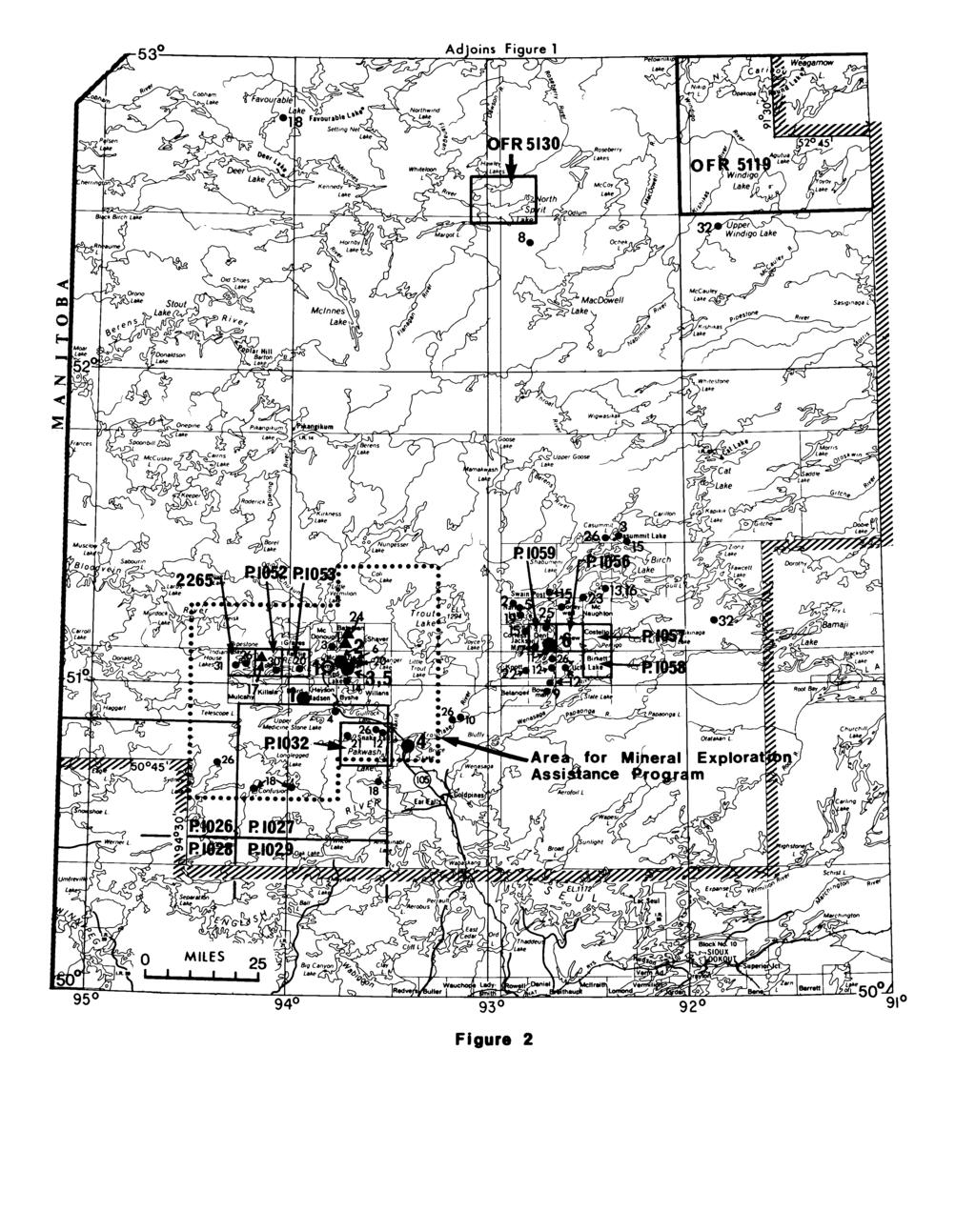
9 REPORT of the NORTHWESTERN REGIONAL GEOLOGIST and KENORA RESIDENT GEOLOGIST by R.C. Beard and W.R. Scott CONTENTS Introduction Regional Geologist's Activities Mining Activity Exploration Activity Base-Metal Exploration Uranium Exploration Gold Exploration Recommendations for Exploration Property Examinations L. Pidgeon (Gold Occurrence) Uranium Occurrences Belacoma Mines Limited Prospect Geological Reconnaissance Felsic Porphyry Bodies of Questionable Origin Mine Centre Area Sand and Gravel Access Roads Geological Branch Activities Research by Other Organizations ODM Maps and Reports Issued by the Geological Branch in Other Ontario Ministry of Natural Resources Publications Issued in Recent Publications and References Page TABLES 1 Exploration Activity in Assessment Work Received in FIGURE l Resident Geologist's District
 Ni.Cu EXPLANATION * Exploration Activity (Keyed to Table 1) Properties or Areas Described in Report (Keyed to Text of Report).")
10 Figure 1 KENORA RESIDENT GEOLOGIST'S DISTRICT Producing Mine 1. Maybrun Mines Ltd. Au,Cu (on standby in ) Operating Mill 1. Consolidated Canadian Faraday Ltd. (Ore from Dumbarton Mine in Manitoba) Ni.Cu EXPLANATION * Exploration Activity (Keyed to Table 1) Properties or Areas Described in Report (Keyed to Text of Report). New Maps and/or Reports (ODM) with number P - Preliminary Map Coloured Geological Map Boundary of Resident Geologist's District
11 REPORT of the NORTHWESTERN REGIONAL GEOLOGIST and KENORA RESIDENT GEOLOGIST by R.C. Beard 1 and W.R. Scott 2 INTRODUCTION The Regional Geologist's office for Northwestern Ontario, located in Kenora, is staffed by R.C. Beard (Regional Geologist), W.R. Scott (Geological Assistant), and B. Stockham (Secretary). During the summer months, two technicians were retained, one under the "Experience '75" program, to revise and index the assessment files. J.C. Davies, field geologist with the Pre cambrian Geology Section of the Ontario Division of Mines, worked out of the Kenora office for several months prior to his departure for Africa. REGIONAL GEOLOGIST'S ACTIVITIES During, several of the operating mines and mining properties under development in the Northwest ern Region were visited. These included the Griffith Mine near Ear Falls, the mill of Consolidated Canadian Faraday Limited at Werner Lake, Union Miniere Explor ations and Mining Corporation Limited's Thierry mine under development near Picket Lake, and the Maybrun mine (Maybrun Mines Limited) east of Sioux Narrows. In addition to these, seven past-producing gold and copper mines were visited as well as 21 other mineral properties, which are listed in a later section of this report. Mineral potential studies were prepared by the staff for Ministry land-use plans covering the Lake of the Woods planning area, the Rainy Lake planning area, the Tri-Municipal (Kenora Keewatin Jaffray Melick) plan ning area, and the Aulneau Peninsula, as well as several areas being considered for wilderness parks or park re- Regional Geologist, Ontario Ministry of Natural Resources, Provincial Building, 808 Robertson Street, Kenora, P9N 3X7. o Regional Geologist's Assistant. serves. The identification of areas of high mineral potential is especially critical for the latter, where large tracts of land could be withdrawn from exploration. In an endeavor to meet the public demand for cottage lots in the region, the Ministry is preparing development plans for a number of lakes which are being considered for both regular and remote cottaging devel opment. Although only small parcels of land are in volved and withdrawal of mining rights is not a problem, mineral potential evaluations were prepared for these plans to identify possible future conflicts between re creational and mining activities. An aggregate-potential study of the Lake of the Woods planning area was undertaken in the latter part of the year, as part of the planning process for the Ministry's Lake of the Woods Land Use Plan. A number of compilation studies were undertaken by the Kenora geological staff, including: i) a compila tion of all known uranium occurrences in the Kenora Mining Division, listing name, location, and short sum mary of geology and type and amount of work carried out on the property, accompanied by a location map, ii) a compilation outlining areas of known ultramafic rocks having potential for soapstone deposits, iii) a list ing of all known shafts and mine workings in the Tri- Municipal area, and iv) a listing of past-producing mines, with information on the amount and type of ore mined, in the Kenora Mining Division. Most of this compilation work was carried out by W.R. Scott, Geological Assis tant. Several of these compilations are to be placed on Open File in the near future. An updating and revision of the Kenora assessment files was commenced in. The Kenora area has had a colourful mining history dating back to the late 1800s, but much of the data contained in the files is old and was obtained from a number of sources. The pre sent filing system includes cross-indexing of data by location, company name, and commodity. Index map overlays, showing the geographic location of all data in the files are being prepared and are keyed to an accom panying list indicating the file number, company name, commodity, and year and type of work performed.
 to a number of Junior Ranger camps and other student groups during the spring and summer.")
12 NOR 111W K S TER N-KENORA Copies of these maps and lists will be available at the Kenora Regional Geologist's office, as they arc com pleted. Lectures and field trips on geology and mining were given by W.R. Scott (Geological Assistant) to a number of Junior Ranger camps and other student groups during the spring and summer. Some reconnaissance geological mapping was carried out by the authors in a number of areas, in order to up date the Kenora Fort Frances Sheet of the Geological Compilation Series (Davies and Pryslak 1967) and to outline favourable areas for mineral exploration. Short visits were made to five of the field parties of the Precambrian Geology Section mapping in the North western Region. MINING ACTIVITY No production was reported from the Kenora Min ing Division in. The Maybrun Mines Limited property, leased to Sheridan Geophysics Limited and located near Atikwa Lake east of Sioux Narrows, con tinued throughout the year on a standby basis only, awaiting improvements in metal prices. However, some exploratory surface drilling was carried out on pre viously known gold zones located to the north of the main pit area. The mill of Consolidated Canadian Faraday Limited at Werner Lake continued milling copper-nickel ore trucked in from the Dumbarton mine in Manitoba. EXPLORATION ACTIVITY Mineral exploration continued as a fair pace in the Kenora Mining Division in, although not at quite the same level as the previous year. Claims recorded in numbered 1677 compared with 2653 recorded in, a decrease of 37 percent. This decrease in claim staking is offset somewhat by the amount of assessment work filed, which increased slightly. In, 57,234 days of assessment credit was recorded, up 3 percent from the 55,732 days recorded in. Base-Metal Exploration Much of the total activity noted above was a result of the continuation of integrated base-metal programs initiated by major companies in previous years, although some new programs were started as well. Companies active in the area included Hudson Bay Exploration and Development Company Limited, Hudson Bay Oil and Gas Company Limited, Sherritt Gordon Mines Limited, The International Nickel Company of Canada Limited, Kerr Addison Mines Limited, Noranda Exploration Com pany Limited, Amoco Canada Petroleum Company Limited, The Hanna Mining Company Limited, and Newmont Mining Corporation of Canada Limited. The Shoal Lake Lake of the Woods Kakagi Lake metavolcanic belt continued to receive the most inten sive effort during the year, with a number of companies carrying out extensive programs, especially ground geo physics and diamond drilling. Results in this area have not been too encouraging to date, and only pyrite and graphite have been "discovered". Other areas which received attention were the Wabi goon area and the Boyer Lake area south of Dinorwic, the Raleigh Lake area west of Ignace, the Werner Lake, Bee Lake, and Oak Lake Separation Lake metavolcanic belts north of Kenora, the Otukamamoan area north west of Mine Centre, the Rowan Lake area east of Sioux Narrows, the Lawrence Lake area east of Rowan Lake, and the Mine Centre area. Uranium Exploration Uranium exploration accounted for part of the ex ploration activity in. Most of these programs are still in the early stages, largely consisting of reconnais sance surveys and examination and testing of previously known occurrences, although some airborne radiometric surveys and detailed ground surveys were undertaken. The northern metasedimentary section of the Eng lish River Subprovince and the Tustin Bridges metavol canic belt west of Vermilion Bay, received the most attention. Most of the previously known occurrences have now been restaked and a number of new occur rences discovered. Several new uranium discoveries were reported within the Wabigoon Subprovince. Gold Exploration Interest in gold exploration decreased somewhat, obviously a result of lower and unstable gold prices. Few of the major companies showed much interest in gold properties in the Kenora District. In fact, one major program, in the Dogpaw Lake area, was termin ated during the year. Old gold prospects continue to be restaked by individuals as they come open but only a few of the properties have been optioned, and then usually by smaller mining companies. RECOMMENDATIONS FOR EXPLORATION i) The Watten Halkirk Townships area east of Fort Frances is an area noted for its extensive base-metal mineralization. Significant occurrences of copper, copper-nickel, copper-zinc, and molybdenum have been discovered, and extensive work has been carried out on a number of the properties by both individuals and com panies. What is believed to be a magnetic, mafic tuff unit containing copper, nickel, and zinc, is currently being
13 tested on the properties of G. Armstrong (Pocket Pond prospect) and Belacoma Mines Limited, and is of special interest. There appear to be similarities between the geological environment here and the Trout Bay area west of Red Lake where Cochenour Willans Gold Mines Limited has outlined significant deposits of both copperzinc-silver and copper-nickel mineralization (Canadian Mines Handbook -, p.80). There is no record of any recent effort in the Fort Frances area to tie all the geology and mineralization together and to formulate a good working hypothesis on the origin of the mineralization, as a guide to future exploration. Therefore, a detailed geological-geochemical study of the area, with comparisons with similar environments elsewhere, would seem to be warranted. Exploration of the above-mentioned magnetic unit in Halkirk Township should be continued and an attempt made to identify similar lithologic units else where in the area. ii) There is evidence to suggest that the four felsic por phyry bodies described below are at least partially of extrusive origin and that the more rhyolitic and frag mental phases represent rhyolite domes developed at volcanic centres. The probability is good of finding exhalative, base-metal, sulphide deposits of the proximal type, as well as gold mineralization, in or adjacent to these and other similar porphyries. No work has been recorded on the Esox Lake porphyry and this area difinitely warrants further investigation. Numerous other small "porphyry plugs" surrounded by metavolcanics may be of similar origin and should also be con sidered. Several of the more obvious include those at Furlonge Lake west of Esox Lake; Robinson Lake in Phillips Township; near Finland in Potts Township; Mather Island, Lake of the Woods, south of Kenora; north of Boyer Lake south of Dinorwic; Wapus Lake south of Dogpaw Lake; and Western Peninsula of Lake of the Woods. Hi) On the assumption that the pegmatitic uranium occurrences within and along the boundaries of the Eng lish River Subprovince are a result of anatexis of uranium-rich metasediments, as postulated, a search for the source beds within the Subprovince should perhaps be considered. The joint Ontario Division of Mines- Geological Survey of Canada reconnaissance, airborne, gamma-ray spectrometer survey flown in late in the Ignace Sioux Lookout area, for release early in 1976, will hopefully indicate broad regional trends and might reveal specific metasedimentary units with anom alous radioactivity. Past Producing Mines Gold: Champion mine, Haycock Township Sultana mine, Sultana Island, Lake of the Woods Wendigo mine, Manross Township Kenricia mine, west of Kenora Olive mine, Mine Centre area Redeemer mine, south of Dryden Copper: Prospects and Occurrences Gold: Uranium: Base-Metals: Port Arthur mine, Mine Centre Area L. Pidgeon occurrence, Avery Township Roseman vein occurrence, Jaffray Haycock Townships Barber Lake occurrence, Mine Centre area Byberg occurrence, MacNicol Township F.O.B. Mining and Exploration Limited occurrence, Temple Township Tudale Exploration Limited occurrence, Umfreville Lake area Davidson occurrence, Umfreville Lake area Aerobus Lake occurrence, west of Per rault Falls Fairservice occurrence, Bridges Township Cochenour Willans Gold Mines Limited, Trout Bay prospect (Cu, Zn, Ni), west of Red Lake Belacoma Mines Limited prospect (Cu, Ni), east of Fort Frances K. McTavish occurrence (Cu, Ni), east of Fort Frances G. Armstrong's Pocket Pond prospect (Cu, Zn, Ni), east of Fort Frances L. Pidgeon (The Hanna Mining Company option) occurrence (Zn), Mine Centre area J. Harrison's Beaverpond occurrence (Cu, Ni), south of Dryden Alcock Green Bay prospect (Cu), High Lake area Evenlode prospect (Cu, Mo), High Lake area E. Allie (native Cu) occurrence, Lake of the Woods PROPERTY EXAMINATIONS Soapstone: Coste Island occurrence, Lake of the Woods A total of 28 properties or mineral deposits, includ ing several past-producing mines as well as two rock quarries, were examined during the year. These included the following: Rock Quarries Hawk Lake (crushed rock), east of Kenora Vermilion Bay (building stone)

14 NORT/IWKSTKRX KENORA L. Pidgeon (Gold Occurrence) This occurrence (property visit l on Figure 1), located approximately 10 km (6 miles) east of Dinorwic, was discovered by L. Pidgeon in late following log ging operations by Dryden Paper Company. Grab samples from a number of trenches put down on the showing and assayed by Kerr Addison Mines Limited, reportedly ran consistantly over 0.5 ounces gold per ton and one sample containing visible gold assayed around 2 ounces gold per ton. The property was optioned by Kerr Addison Mines Limited which in carried out geological mapping, a magnetometer survey, surface sampling, and put down four diamond-drill holes. Re sults from the diamond drilling reportedly failed to con firm the high gold assays obtained at surface (Kerr Addison Mines Limited, personal communication). The area is underlain by a sequence of mafic to intermediate flows and tuffs. Some conformable felsic porphyry units are also present. The gold mineralization is contained in a conformable quartz-carbonate zone which is highly distorted and brecciated, and contains conspicuous pyrite. The pyrite mineralization, in places, persists into the surrounding mafic rocks. The quartz is cherty looking and is vaguely but irregularly layered locally. Much of the carbonate is reddish-brown iron carbonate. Rather than representing a tectonically fractured quartz-carbonate "vein", as postulated by others, the author suggests that this sulphide-rich quartz-iron car bonate zone represents a volcanogenic chemical sedi ment, brecciated by slumping during deposition, and that the gold is syngenetic in origin. Uranium Occurrences Six radioactive occurrences, listed above, were ex amined (property visit 2 on Figure 1) in. All of these occurrences were notable for their similarity. All were of the "pegmatite" type, occurring in granitic rocks. Most of the radioactivity noted was associated with pegmatitic phases of the granitic rocks; most of the pegmatitic phases, and consequently the radioactive zones, were very irregular and erratic. With few excep tions, mineralized zones were either adjacent to or in proximity to layers or xenoliths of highly metamor phosed, partially assimilated, biotitic sedimentary rocks. The radioactive minerals, often accompanied by yellow uranophane staining, are suspected to be largely uran inite. Of special significance is the strong association of the radioactivity with partially assimilated metasediments. This suggests that the original concentration of radioactive minerals may have been a result of sedimen tary processes and that the uranium was then further concentrated and remobilized in the pegmatitic phases during anatexis of the metasediments. Grab samples, collected by the ODM staff from the various properties visited, assayed (by Mineral Research Branch, Ontario Division of Mines), as follows: Byberg occurrence: percent UoOg F.O.B. Mining Company occurrence: percent and percent UoOg Tudale Exploration Limited occurrence: per cent and percent UoOg Davidson occurrence: 0.05 percent, 0.03 percent, and percent UgOg Aerobus Lake occurrence: 0.03 percent and percent UoOg Fairservice occurrence: percent and percent UoO Belacoma Mines Limited Prospect This prospect (property visit 3 on Figure 1) is lo cated near Nickel Lake Station, Halkirk Township, east of Fort Frances. Copper-nickel mineralization has been investigated for a number of years, and previous work has included trenching, geophysical surveys, and dia mond drilling by a number of companies and individuals. Work by Belacoma Mines Limited since 1972 consisted of trenching and diamond drilling which has revealed additional zones of mineralization. Pyrrhotite and chalcopyrite mineralization occurs largely as small blebs, disseminated grains, and fracture fillings in a dark, very magnetic, mafic unit. This unit has been described as a mafic tuff by workers in the area. A thick sequence of metasediments lies to the west of the tuff unit, and mafic flows and coarse-grained mafic intrusions (?) lie to the east. The dark magnetic tuff unit is foliated but generally non-layered and is composed largely of hornblende and magnetite. The drilling has also intersected lighter coloured more siliceous, layered metasediments or felsic tuffs, in cluding some jasper, within the mafic tuff unit. Minor sphalerite and molybdenite were also observed in the drill core. Grab samples recently obtained from trenches at the south end of the claim group reportedly ran 0.89 percent copper and 0.50 percent nickel. The Belacoma Mines Limited property adjoins G. Armstrong's Pocket Pond prospect to the northwest. Diamond drilling on the Pocket Pond property in also reportedly intersected significant base-metal mineralization in what appears to be the same strati graphic unit (G. Armstrong, personal communication). GEOLOGICAL RECONNAISSANCE Felsic Porphyry Bodies of Questionable Origin Several small- to medium-sized felsic porphyry bodies, believed to be of volcanic or subvolcanic origin, were examined in an attempt to determine their eco nomic potential and to confirm their origin. The por phyry bodies visited were the Esox Lake body southwest
 was map ped by J.E. Thompson (1934) as quartz porphyry of Algoman age, with an implied intrusive origin.")
15 of Lower Manitou Lake, the Dash Lake body in the Pipestone Lake area, the Washeibemaga Lake body in the Upper Manitou-Stormy Lakes area, and the High Lake porphyry west of Kenora. The Esox Lake body (visit 4 on Figure 1) was map ped by J.E. Thompson (1934) as quartz porphyry of Algoman age, with an implied intrusive origin. The current reconnaissance confirmed the body to be quartz porphyry, consisting of small- to mediumsized quartz phenocrysts in a fine-grained matrix of pot ash feldspar and quartz. The rock rarely has a typical granitic texture; rather it has a distinct rhyolitic appear ance, often exhibiting what appears to be vague flow banding, and containing few mafic minerals. Some sec tions are, however, more intermediate in composition, have a distinct foliated to layered appearance resembling intermediate tuff, and in places contain conspicuous disseminated pyrite. One outcrop, opposite the small island near the centre of Esox Lake, contains stretched fragments of porphyry in a fine-grained, foliated and porphyritic matrix, probably representing a volcanic fragmental or agglomeratic unit. Also of special interest is a narrow horizon of volcanogenic chemical and clastic metasediments, located on the north side of the mouth of Mirror Bay. This narrow unit of metasediments is exposed for approximately 100 m (300 feet) along the shore of the peninsula and is situated well within the interior of the porphyritic body. Very prominent is a narrow, irregu larly layered very rusty horizon consisting of cherty quartz, feldspar, and sericite. This unit contains up to 10 percent pyrite. In contact with this volcanogenic chemical meta sediment to the south is an apparently narrow, brec ciated conglomerate unit, which has a fresh appearance. It is composed of sub-angular, poorly sorted clasts locally cemented by carbonate, ranging in composition from slaty metasediment to porphyry and in size up to 25 cm (6 inches). The porphyry body is in contact to the north with a sequence of mafic to intermediate pillowed flows, tuffs, and well-bedded argillaceous metasediments. At the east end of High Lake, west of Kenora, two mineral showings (visit 5 on Figure 1) in felsic porphyry were examined. The host rock at both these prospects is a very siliceous quartz porphyry consisting of small- to medium-sized phenocrysts of quartz in a fine-grained rhyolitic matrix. The porphyritic appearance varies from place to place. Some structures resemble flow layering. On the former Evenlode Mines Limited prospect at the east end of High Lake, pyrite, chalcopyrite, and molybdenite are finely disseminated in porphyry and heavily concentrated in a highly sheared sericitic zone within the porphyry. This mineralized sericite zone, which has been traced for about 500 m (1600 feet) by drilling and trenching, contains irregular masses and stringers of quartz, and the sulphides, especially pyrite, are more concentrated in these siliceous sections. On the old Alcock prospect, located about 450 m (1500 feet) north of the east end of High Lake, "por phyry-type" copper mineralization, carrying significant gold values, has been exposed by trenching over a large area. The sulphides are mostly disseminated in the por phyritic host rock but also are locally concentrated along narrow fractures. Mineralization was seldom associated with quartz veining in the outcrops examined although drill logs on file at the Kenora Regional Geol ogist's office indicate that such an association is not uncommon. In the area of the main showing, the por phyry is shown by Davies (1965) as being in contact with a large tongue of mafic metavolcanics to the south. The actual contact between the porphyry and the metavolcanic-metasedimentary sequence is exposed in one of the trenches where the porphyry is in contact with a band of magnetite-chert iron formation. Intrusive rela tionships were not evident. Some irregular rusty sul phide stringers or zones up to a metre in width, can be traced for lengths of over 6 m (20 feet) through the por phyry. These sulphide concentrations are subparallel to the porphyry-iron formation contact and appear to be syngenetic concentrations. Both the Dash Lake porphyry (visit 6 on Figure 1) and the Washeibemaga Lake porphyry (visit 7 on Fig ure 1) are rhyolitic in part, and both contain some very fragmental sections. Although parts of the above porphyry "plutons" may be true sub-volcanic intrusions, it is suggested that the porphyries may represent, in part, rhyolitic domes, made up of rhyolite flows, but including some associated felsic pyroclastics and proximal volcanogenic chemical sedimentary rocks. As such they offer excellent explor ation targets, both for stratabound, exhalative-type base-metal deposits and for porphyry-type copper and gold deposits. Mine Centre Area Geological reconnaissance and several prospect examinations in the Mine Centre area in early revealed the presence of copper-zinc mineralization associated with what is believed to be highly sheared fel sic pyroclastic rocks. This was in an area shown simply as mafic metavolcanics and metasediments on available geological maps (Davies and Pryslak 1967; Tanton 1936). On this basis, coupled with the fact that a min ing company had recently initiated a major exploration program in the area, a reconnaissance geological mapping program of the area between Mine Centre and Glenorchy (visit 8 on Figure 1) was undertaken by W.R. Scott. This mapping revealed several rather significant features. Firstly, felsic metavolcanics are much more ex tensive throughout the area than previously noted, and secondly, the presence of stratabound sulphides indi cates a geological environment favorable for stratabound volcanogenic bast-metal deposits. The south part of the map-area is underlain by the

16 NORTHWESTERN KENORA Seine Conglomerate, whereas the western and northern part of the area, between the Seine Conglomerate and the Turtle River, is underlain by a mixed sequence of felsic to mafic mctavolcanic tuffs, flows, and minor agglomerate, with one volcanic conglomerate section. The contact between the metavolcanics and granite to the north lies north of the Turtle River and was not lo cated in the current mapping. The Seine "Series" to the south is predominantly a polymictic conglomerate consisting of large, well rounded pebbles and boulders of volcanic, granitic, and argillaceous rocks set in a dark, fine-grained greywacke matrix. A narrow unit of conglomerate, interbedded or folded within the metavolcanics in the western part of the area, is distinctively different in character from the southern unit. It consists of clasts of quartz pebbles, and some clasts of jasper and argillite, set in a finely bedded, felsic matrix. Although there are some more mafic units, the metavolcanics of the area are predominantly felsic to intermediate in composition. They are highly variable, being light grey, massive, aphanitic rhyolite flows near the northwest corner of the area and near Glenorchy, whereas to the south they are white to pale green, highly foliated sericitic tuffs with conspicuous quartz eyes and carbonate content. In general, the metavolcanics are more felsic to the north. Some thicker massive to pillowed mafic flows out crop near the western margin of the area. However, the mafic rocks are more commonly dark green chloritic tuff which forms discontinuous beds from 5 cm up to 5 m (several inches to 10 or 20 feet) in width. Zinc, copper and iron sulphide mineralization, with occasional high silver values, is found in sheared sericitic felsic tuff at the L. Pidgeon occurrence (Kerr Addison Mines Limited option). This showing is located south of Highway 11 about 3 km (P/4 miles) east of the Mine Centre turnoff. The base-metal mineralization, which is discontinuous over 1800 m (6,000 feet) of strike length, was previously reported by King (1970). Recent trenching has revealed additional mineralization north of Highway 11, along strike. A grab sample from this zone assayed 19.0 percent zinc, 0.13 percent copper, and 0.06 percent lead (assay by Mineral Research Branch, Ontario Division of Mines). Geophysical surveys, geological map ping, and diamond drilling were carried out on the Pid geon property by Kerr Addison Mines Limited in Copper mineralization has also been noted in a quartz vein in very dense, cherty rhyolite approximately 0.8 km ('/2 mile) west of the Pidgeon occurrence. A grab sample of coarse chalcopyrite and pyrite disseminated throughout "bull" quartz assayed 0.43 percent copper and 0.01 ounces gold per ton (assay by Mineral Research Branch, Ontario Division of Mines). This mineralization occurs in a different stratigraphic horizon and in a dif ferent type of host rock than the Pidgeon occurrence. About 11 km (7 miles) to the west of the Pidgeon property is the old Port Arthur copper mine which pro duced over kg (431,000 pounds) of copper in 1916 (Regional Geologist's files: "Stratmat Limited", Ontario Ministry of Natural Resources, Kenora). The copper-zinc mineralization at this property is similar to that to the east, occurring in sericite and chlorite schists. Although some of the more mafic schists show remnant amygdaloidal structures, indicating an extrusive origin, well-bedded, pale felsic units have also been noted on the property and observed on the rock dumps. SAND AND GRAVEL A study of the sand and gravel potential of the Lake of the Woods planning area was carried out in. This study, which is not an inventory in that it lacks quantitive data, was largely restricted to areas accessible by road. Areas of probable sand and gravel deposits have been outlined on a series of basemaps at a scale of l inch to 2 miles (1:126,720), which are to be placed on Open File for public use in the Kenora Regional Geol ogist's office in the near future. ACCESS ROADS No work was carried out in on the southern part of the Manitou Access Road, under construction between the Fort Frances area and Dryden. This section is open to about mile 46 (74 km) near Eagle Rock Lake. Parts of the northern section were upgraded in. Near Mine Centre, the Turtle River Access Road has been extended to about 19 km (12 miles) north of Highway 11, to Otter Rapids. A paper company access road is under construction from the Manitou Access Road near Winkle Lake to Cedar Narrows of the Manitou River, providing access to Esox Lake. GEOLOGICAL BRANCH ACTIVITIES Geological mapping by the Precambrian Geology Section was carried out in three areas within the Kenora District during. G. Edwards continued mapping in the Kakagi Pipestone Lakes area east of Nestor Falls, completing the Pipestone Lake (South) map-area. In the Manitou Lakes area south of Dryden, C. Blackburn com pleted the Boyer Meggisi Lakes map-area. Operation Kenora Ear Falls, a helicopter-supported reconnaissance mapping project led by F. Breaks and W. Bond, was con tinued in the English River Subprovince in the area east of the Red Lake Road. A joint federal-provincial, reconnaissance, airborne, gamma-ray spectrometer survey, at a 5 km (3 mile) line spacing, covering NTS quadrangles 52G and 52J, was flown in the Ignace Sioux Lookout area. RESEARCH BY OTHER ORGANIZATIONS Geoscience research projects by The Centre for Pre- 8
17 cambrian Studies at the University of Manitoba were continued in the Kenora Mining Division in, as follows. 1. Seismic studies, including a common depth point reflection survey across the Sioux Narrows "green stone" belt to the east of the Aulneau Dome, were carried out, in an attempt to delimit the dip and depth extent of the near-vertical boundaries of the belt. 2. Gravity surveys of the Lake of the Woods area were extended to the west to include Shoal Lake. The survey now encompasses the area from the eastern margin of the Aulneau Dome, through the Western Peninsula to the Ontario Manitoba border. 3. Geological studies of the stratigraphy and geo chemical relations of the volcanic sequences in the Kakagi Lake, Manitou Stormy Lakes, and eastern Lake of the Woods areas were continued by M. Morrice. 4. Field mapping in the Eastern Peninsula and White fish Bay regions, Lake of the Woods, was carried out by B. Brown, to investigate the geometry and se quence of deformation of the volcanics and intrusives, with special emphasis on the role of pluton emplacement. 5. Geological studies in the Separation Lake metavolcanic belt were started by G. Beakhouse, to com pare it to other Archean volcanic piles and to attempt to determine its position within the "stan dard" Archean volcanic sequence. 6. Geological studies of the volcanic stratigraphy in the Wiley Bay, Lake of the Woods area were ini tiated by D. Carr. 7. Mineralization studies within the High Lake Stock were completed by J. Pedora. Geological studies were also carried out in the area by graduate students from McMaster University in, as follows. 1. C. Gower carried out detailed geological mapping of gneissic and intrusive rocks around Black Sturgeon Lake northeast of Kenora (Ph.D. thesis project). 2. C. Westerman took part in Operation Kenora Ear Falls of the Ontario Division of Mines, relating his reconnaissance mapping throughout the English River Subprovince to his thesis area around Cliff Lake and Cedar Lake, north of Vermilion Bay (Ph.D. thesis project). 3. F. Longstaff continued geological research, includ ing oxygen isotope work and geochronology, on a number of high level intrusion and English River gneissic bodies (Ph.D. thesis project). 4. D. Birk also continued research work, especially iso topic dating, on several high level intrusions includ ing the Esox Lake, Uphill Lake, Burditt Lake, and Flora Lake stocks (Ph.D. thesis project). 5. M. Wolff undertook a feasability study on isotopic dating of the ultramafic rocks at Kakagi Lake (M.Se. thesis project). ODM MAPS AND REPORTS ISSUED BY THE GEOLOGICAL BRANCH IN P.970 Uranium and Thorium Deposits of Ontario, West Central Sheet, Districts of Kenora (Patricia Portion), Thunder Bay, Algoma and Cochrane. Compilation by James A. Robertson 1973,. Scale l inch to 16 miles or 1:1,013,760. P Pipestone Lake Area (Northern Half), District of Kenora (52 F/4E). Geology by G.R. Edwards and assistants,. Scale l inch to V4 mile or 1:15,840. P Rowan Lake Area, District of Kenora (52 F/5E); Kenora Data Series. Compilation by R.C. Beard and G. Garratt,. Scale l inch to Vi mile or 1:15,840. P.1025 Pipestone Lake Area, District of Kenora (52 F/4E); Kenora Data Series. Compilation by R.C. Beard and G. Garratt,. Scale l inch to Vi mile or 1:15,840. P.1026 Operation Kenora Sydney Lake, Eagle- Sydney Lakes Sheet, District of Kenora (52 L/9W, 10, HE, 14E, 15, 16W). Geology by F.W. Breaks, W.D. Bond, G.H. Mcwilliams, C.F. Gower and Denver Stone, and other assistants,. Scale l inch to l mile or 1:63,360. P Operation Kenora Sydney Lake, Umfre ville Separation Lakes Sheet, District of Kenora (52 L/1W, 2, 3E, 6E, 7, 8W). Geol ogy by F.W. Breaks, W.D. Bond, C.F. Gower, D. Findlay and Denver Stone and other assistants,. Scale:! inch to l mile or 1:63,360. P.1029 Operation Kenora Sydney Lake, Oak- Indian Lakes Sheet, District of Kenora (52 K/4, 5; 52 L/1E, 8E). Geology by F.W. Breaks, W.D. Bond, G.H. Mcwilliams, C.F. Gower and D. Findlay and other assistants,. Scale l inch to l mile or 1:63,360.
18 NOR TIWESTERN KENORA P Operation Kenora Sydney Lake, Kenora Minaki Sheet, District of Kenora (52 E/16E; ; 52 K/4; 52 L/1E). Geology by F.W. Breaks, W.D. Bond, G.II. Mcwilliams, C.F. Gower and other assistants,. Scale l inch to l mile or 1:63,360. P.1031 Operation Kenora Sydney Lake, Gordon- Big Canyon Lakes Sheet, District of Kenora (52 L/14E, 15; 52 L/1W, 2, 3E). Geology by F.W. Breaks, W.D. Bond, G.II. Mcwilliams, C.F. Gower and other assistants,. Scale l inch to l mile or 1:63,360. P.1041 Iron Deposits of Ontario, West Central Sheet, Districts of Kenora (Patricia Portion), Thunder Bay, Algoma and Cochrane. Com pilation by FI.D. Meyn and James A. Robertson 1972, 1973,. Scale l inch to 16 miles or 1:1,013,760. P Nickel Deposits of Ontario, Wrest Central Sheet, Districts of Kenora (Patricia Portion), Thunder Bay, Algoma and Cochrane; Min eral Deposits Series. Compilation by M. Jost. Scale l inch to 16 miles or 1:1,013,760. Map 2302 MacNicol and Tustin Townships, Kenora District (52 E/16, 52 F/13). Geology by A.P. Pryslak and assistants, Scale l inch to Vz mile or 1:31,680. Map 2319 Cedartree Lake, District of Kenora (52 F/5). Geology by J.F. Davies, J.A. Morin and assis tants, Scale l inch to Vz mile or 1:31,680. OFR5126 Index to Exploration Reports Filed in (1) Assessment Work Reports (2) Reports Received Under Ontario's Mineral Explora tion Assistance Program (MEAP). Compiled by Geoscience Data Centre,. OFR5134 Clay and Shale Deposits of Ontario; by G.R. Guillet; approx. 265p., 28 tables, 39 figures, 2 maps. OFR5147 Mineral Exploration Assistance Program (MEAP), Fiscal Year -75, by S.A. Ferguson, F.G. Da Silva and S.C. Sun; 73p., 2 figures, 7 appendices. OFR5150 Preliminary Township and NTS Index to Ontario Geoscience Reports and Maps,, 1201p. (microfiche only). IMR33 Reprint A Guide to Site Development and Rehabili tation of Pits and Quarries by Anthony M. Bauer; 62p. including photographs and figures. Annual Report of the Regional and Resident Geologists,. Edited by E.G. Pye, Director, Geological Branch, 241p. Mineral Deposit Studies, Mineral Potential Evaluation and Regional Planning in Ont ario; by James A. Robertson, 42p. Summary of Field Work,, by the Geological Branch. Edited by V.G. Milne, D.F. Hewitt, K.D. Card and J.A. Robertson, 158p. OTHER ONTARIO MINISTRY OF NATURAL RESOURCES PUBLICATIONS ISSUED IN MPBP l Review The Impact of Taxation and Environmental Controls on the Ontario Mining Industry by G. Anders, W.P. Gram and S.C. Maurice; 197p. Published by the Mineral Resources Branch. Ontario Mineral Review, 124p. RECENT PUBLICATIONS AND REFERENCES Azis, A., Barry, G.S. and Haugh, I. 1972: The Undiscovered Mineral Endowment of the Canadian Shield in Manitoba, A Fed eral Provincial Co-operative Study; Min eral Bulletin MR 124, Mineral Resources Branch, Canada Department of Energy, Mines and Resources, 42p. Centre for Precambrian Studies : Annual Report; Centre for Precam brian Studies, University of Manitoba, Winnipeg, 253p. Coker, W.B. and Nichol, I. : The Relation of Lake Sediment Geochem istry to Mineralization in the Northwest Ontario Region of the Canadian Shield; Econ. Geol., Vol.70, p Davies, J.C. 1965: Ewart Forgie Area, Kenora District; Ont ario Dept. Mines, Map 2069, scale l inch to Vi mile. Geology Davies, J.C. and Pryslak, A.P. 1967: Kenora Fort Frances Sheet, Kenora, Rainy River Districts; Ontario Dept. Mines, Map 2115, Geol. Comp. Series, scale l inch to 4 miles. Compilation
19 Geological Survey of Canada : Uranium Exploration '75; Paper 75-26, presented to Prospectors and Developers 43rd Annual Convention, Toronto,, 71p. Goodman, R.J. and Johnson, R. : Canadian Iron Ore Industry Statistics, ; Canada Department of Energy, Mines and Resources, MR144, 39p. Hall, D.H. : Long-Wavelength Aeromagnetic Anomalies and Deep Crustal Magnetization in Mani toba and Northwestern Ontario, Canada; J. Geophys., Vol.40, p Hsu, Mao-Yang 1971: Analysis of Strain, Shape and Orientation of the Deformed Pebbles in the Seine River Area, Ontario; unpublished MSc. Thesis, McMaster University, Hamilton, Ontario, 179p. (Copy of Introduction, Geologic Setting and Conclusions in Regional Geol ogist's files, Ontario Ministry of Natural Resources, Kenora). King, H.L. 1970: Kenora District; p in Annual Report of Resident Geologists' Section, Geological Branch, 1969, Part l, Ontario Dept. Mines, MP33, 67p. Lang, A.H., Griffith, J.W. and Steacy, H.R. 1962: Canadian Deposits of Uranium and Thor ium; Geol. Surv. Canada, Econ. Geol. Ser. No. 16, 2nd ed. (published 1962). Approx. 320p. Manitoba Department of Mines, Resources and Envi ronmental Management : Summary of Geological Field Work ; Mineral Resources Division, Exploration and Geological Survey Branch, Geological Paper 2/75, 44p. McRitchie, W.D. and Weber, W. (ed.) 1971: Geology and Geophysics of the Rice Lake Region, Southeastern Manitoba (Project Pioneer); Maps and Figures to accompany Manitoba Department of Mines and Nat ural Resources Publication Mining Association of Canada : Mining. What It Means to Canada; Mining Assoc. Canada, booklet, 64p. : Facts and Figures; Mining Assoc. Canada, pamphlet, 48p. Ministry of the Environment of Ontario 1973: Effluent Guidelines and Receiving Water Quality Objectives for the Mining Industry in Ontario; Guideline summary, 7p. Moorbath, S. : Evolution of Precambrian Crust from Strontium Isotopic Evidence; Nature, Vol. 254, p Tanton, T.L. 1936: Mine Centre Area, Rainy River District, Ontario; Geol. Surv. Canada, Map 334A, scale l inch to Vz mile. Geology Thomson, J.E. 1934: Geology of Straw Manitou Lakes Area; Ontario Dept. Mines, Vol.43, pt.4, 32p. Accompanied by Map 43a, scale l inch to l mile. 11
20 Table l Exploration Activity in The following is a list of individuals and companies known to be engaged in exploration within the Kenora Mining Division in, and the type of work undertaken in each case. The numbers corres pond to the numbered areas on Figure 1. Individual or Company Type of Work Amoco Canada Petroleum Co, Ltd. 2. Belacoma Mines Ltd. 3. Border Cities Ready Mix Cement Ltd. 4. Canadian Nickel Co. Ltd. 5. Cone, R., Sr. 6. Consolidated Canadian Faraday Ltd. 7. Cousineau, L. 8. Doborzynski, Z. 9. Falconbridge Nickel Mines Ltd. 10. F.O.B. Mining S Explor ation Ltd. 11. Gambit Explorations Ltd. 12. Goldray Mines Ltd. 13. Hanna Mining Co., The 14. Harrison, J. 15. Hudson Bay Exploration S Development Co. Ltd. Ground follow-up of airborne geophysical surveys in the Raleigh Lake area. Geological mapping, ground geophysical surveys, and diamond drilling in Halkirk Twp. Trenching and diamond drilling in Halkirk S Watten Twps. Ground follow-up of airborne geophysical surveys in the Shoal Lake-Lake of the Woods and Vermilion Bay areas. Trenching in the Grassy Lake area. Ground geophysical survey in the Reynar Lake S Werner Lake areas. Stripping and trenching in Halkirk and Farrington Twps. Ground geophysical surveys in the Shoal Lake area. (Imperial Oil Option) Diamond drilling in the Dogpaw Lake area. Trenching in Temple Twp. Diamond drilling in the Rickaby Lake area. Diamond drilling in the Dogpaw Lake area. (Falconbridge Option) Geological mapping and ground geo physical surveys in the Grassy Lake, Little Turtle Lake, Reed Lake, and Wild Potato Lake areas. Diamond drilling in the Contact Bay area. Ground geophysical surveys in the Brooks Lake, Clearwater Bay, Dogpaw Lake, Godson Twp., Heronry Lake, Lobstick Bay, MacQuarrie Twp. S Code Twp., Rowan Lake, Turtlepond Lake, Whitefish Bay S Manross Twp., Aulneau Peninsula, Long Point Island, Wiley Bay, Willingdon Twp.; Turam EM surveys in the Butler Lake and Turtlepond Lake areas; and diamond drilling in the Echo Bay S Boys Twp., MacQuarrie Twp. S Code Twp., Monument Bay, Shoal Lake, Whitefish Bay s Manross Twp., and Wiley Bay areas.
21 Individual or Company Type of Work 16. Hudson Bay Oil fi Gas Co. Ltd. 17. Hupchuk, M. 18. Imperial Oil Ltd. 19. Kamlo Gold Mines Ltd. 20. Kerr Addison Mines Ltd, 21. Kuryliw, C. 22. Martin, F. 23. Martin, R. 24. McTavish, K. 25. Noranda Exploration Co, Ltd. 26. Pango Gold Mines Ltd. 27. Rosenblat, R. 28. Sherritt Gordon Mines Ltd. 29. Underwood McLellan S Associates Ltd. 30. Willow Lake Mines Ltd. 31. Yeoman Mining Exploration Ltd. Ground follow-up in Shoal Lake, Echo Bay fi Boys Twp., and Ewart Twp. S Indian Bay areas. Stripping and trenching in Halkirk Twp. Diamond drilling south of Kenora. Diamond drilling in the Buchan Bay area. Ground radiometric surveys, geol ogical mapping, and diamond drill ing in Macnicol and Langton Twps.; geological mapping, geophysical surveys, and diamond drilling in Avery Twp. and the Pipestone Peninsula area; reconnaissance and ground follow-up of airborne radio metric surveys between Vermilion Bay and Sioux Lookout. Ground geophysical survey in the Wiley Bay area. Diamond drilling in the Heronry Lake area. (Noranda Option) Diamond drilling in the Brooks Lake area. (Noranda Option) Trenching in Watten Twp. Ground geophysical surveys in the Heronry Lake, Brooks Lake, and Rowan Lake areas. Diamond drilling in the Dogpaw Lake area. Ground geophysical surveys in the Clearwater Bay area. (Aumac Option) Ground follow-up of airborne geo physical surveys in the Separation Lake-Oak Lake, Western Peninsula, Lawrence Lake, and Vermilion Bay areas. Ground geophysical surveys in the Kawashegamuk Lake, Tabor Lake, Boyer Lake, and Turtlepond Lake areas; diamond drilling in the Kawashegamuk Lake, Tabor Lake, and Boyer Lake areas. (Newmont Option) Geological surveys and sampling in Jaffray, Haycock, and Kirkup Twps. {Rosenblat Option) Ground geophysical surveys in the Reed Lake and Bennett Twp. areas. (International Chemalloy Inc. Option) 13
22 Table 2 Assessment Work Received in Air - Airborne Gee Assess - Assessment Work Gee - Geochemical Survey Au - Gold IP - Induced Polarization Survey BM - Basemetals Mag - Magnetometer Survey 5 DDK (620) - 5 Diamond drill holes totalling 620' MEAP - Mineral Expl. Assistance Program EM - Electromagnetic Survey Report Abb l Pros Rad Res SA Tr U - Prospectus Radiometric Survey - Resistivity Survey - Sampling - Trenching - Uranium Commodity Sought Type of Report Type of Work Performed Vear Toronto File No. Aulneau Peninsuli Hudson Bay Exploration K Development Co. Ltd. Balmoral Lake Geophysical Engineering Ltd. Geochem Beadle Lake 52C/13 NW Hudson Bay Exploration S Development Co. Ltd. l DDK (272) Bennett Twp. 52C/16 SW Yeoman Mining Explor ation Ltd. EM, Mag MEAP A-5 Boyer Lake 4 DDH (412) Underwood McLellan s, Associates Ltd. Assess Assess Assess EM, Mag l DDH (302) l DDH (292) Bridges Twp. 52F/13 SE Imperial Oil Ltd. Geol Brooks Lake 52F/4 NE Martin, R. 7 DDH (2016) Noranda Exploration Co. Ltd. EM, Mag Buchan Bay 52F/11 NE Kamlo Gold Mines Ltd. EM, Mag, IP 7 DDH (1063) Butler Lake 52F/10 NE Hudson Bay Exploration s, Development Co. Ltd. EM Surveys Clearwater Bay 52E/10 NE Aumac Explorations Ltd. EM, Mag Hudson Bay Exploration EM 7 DDH (2104) Rosenblat, R. EM, Mag Code s MacQuarrie Twps. 52E/9 NE Hudson Bay Exploration C Development Co. Ltd. 7 DDH (754) Contact Bay 52F/10 NW Nichro Mines Ltd. 2 DDH (304) Docker Twp. 52F/13 SE Imperial Oil Ltd. Geol Dogpaw Lake 52F/5 SW Falconbridge Nickel Mines Ltd. 3 DDH (1347) Goldray Nines Ltd. Assess 1 DDH (801) Martin, J. Assess Tr Pango Gold Mines Ltd. Assess 2 DDH (1000) Echo Bay s Boys Twp. 52E/10 NW Hudson Bay Exploration t Development Co. Ltd. Assess 2 DDH (674) Hudson Bay Oil t Gas Co. Ltd. Assess Air EM s Mag Ewart Twp. K Indian Bay S2E/11 NE Hudson Bay Exploration K Development Co. Ltd. 2 DDH (956) Hudson Bay Oil s Gas Co. Ltd. Air EM c Mag Godson Twp. 52F/4 NW Hudson Bay Exploration fi Development Co. Ltd. EM Gordon Lake s Smellie Twp. 52F/13 NE MacLeod, J. Grassy Lake 52C/10 NE Ciglen Investments Ltd. 4 DDH (2008) Cone, R., Sr. Halkirk Twp. 52C/11 NE Belacoma Mines Ltd. 5 DDH (430) Border Cities Ready Mix Cement Ltd. BM BM Assess Assess 3 DDH (1605) Hupchuk, M. 14
23 Location NTS File Name Commodity Sought Type of Report Type of Work Performed Year Toronto File No. Halkirk s Farrington Twps. 52C/11 NE Cousineau, L. BM Assess Tr Harper Lake 52F/7 NW Regan, F. Assess 2 DDH (205) Heronry Lake 52F/4 NW Hudson Bay Exploration S Development Co. Ltd. BM Assess EM Martin, F. Au Assess 1 DDH (332) Noranda Exploration Co. Ltd. Au Assess EM, Mag Jaffray, Haycock, s Kirkup Twp. 52E/9 NW Willow Lake Mines Ltd. Au Pros EM, Mag, SA Kawashegamuk Lake 5 2 F/ 8 NW Underwood McLellan S Assess EM, Mag 2 DDH (503) Little Turtle Lake 52C/15 SE Ciglen Investments Ltd. Au Assess 4 DDH (806) Lobstick Bay 52F/5 NW Hudson Bay Exploration s Development Co. Ltd. BM Assess EM Long Point Island 52E/8 NE Hudson Bay Exploration K Development Co. Ltd. BM Assess EM MacQuarrie Twp. 52E/9 SE Hudson Bay Exploration s Development Co. Ltd. BM Assess EM Surveys 7 DDH (754) Monument Bay 52E/7 NW Hudson Bay Exploration s Development Co. Ltd. BM Assess 7 DDH (2244) Napanee Lake 52F/3 NE Noranda Exploration Co. Ltd. BM Assess EM, Mag Reed Lake 52C/16 SW Yeoman Mining Explor ation Ltd. Au MEAP EM, Mag MEAP A-5 Rickaby Lake 52L/11 NE Gambit Explorations Ltd. BM Assess 8 DDH (1036) Rowan Lake 52F/5 SE Hudson Bay Exploration BM Assess EM Noranda Exploration Co. Ltd. BM Assess EM, Mag EM, Mag Regan, F. Assess 2 DDH (205) Shoal Lake 52E/10 SW Hudson Bay Exploration s Development Co. Ltd. BM Assess 9 DDH (3216) Hudson Bay Oil fi Ltd. Gas BM As sess Air EM, Mag Snook Lake 52L/2 NE Sherritt Gordon Mines Ltd. BM Assess 8 DDH (992) Snowshoe Bay 52E/11 SE Hudson Bay Oil s Gas Ltd. BM Assess Air EM, Mag Tabor Lake 52F/9 SW Underwood McLellan G BM Assess Assess EM, Mag 1 DDH (300) Turtlepond Lake 52F/10 SE Hudson Bay Exploration s Development Co. Ltd. BM Assess EM Surveys Underwood McLellan S Assess EM, Mag Turtlepond Lake S Satterly Twp. 52F/10 SE Underwood McLellan 6 Associates Ltd. BM Assess 1 DDH (349) Vista Lake 52F/3 SE Noranda Exploration Co. Ltd. BM Assess EM, Mag Watten Twp. 52C/11 NE Border Cities Ready Mix Cement Ltd. BM Assess Tr Duggan, S. BM Assess 2 DDR (640) McTavish, J. BM Assess EM, Mag, Geol Mctavish, K. BM Assess Tr 1972 Whitefish Bay s Man ro s s Twp. 52E/9 SW Hudson Bay Exploration s Development Co. Ltd. BM BM Assess Assess EM Surveys 3 DDH (611) Wiley Bay 52E/10 SE Hudson Bay Exploration BM BM Assess Assess EM 2 DDB (566)
24
25 REPORT of the RED LAKE RESIDENT GEOLOGIST by W. Valliant CONTENTS Introduction Resident Geologist's Activities Mining Activity Exploration Activity Mineral Exploration Assistance Program Geological Branch Activities Research by Other Agencies ODM Maps and Reports Issued by the Geological Branch in Other Ontario Ministry of Natural Resources Publications Issued in Recent Publications and References Page TABLES 1 Exploration Activity in Assessment Work and Other Information Received in FIGURES 1,2 Red Lake Resident Geologist's District ,19 17
26 Figure 1 RED LAKE RESIDENT GEOLOGIST'S DISTRICT Scale of Miles EXPLANATION Producing Mines 1. Bulora Corporation Ltd. Madsen Division 2. Campbell Red Lake Mines Ltd. 3. Dickenson Mines Ltd. 4. Griffith Mine, The 5. Robin Red Lake Mines Ltd. 6. Selco Mining Corporation Ltd. South Bay Mines Division Au,Ag Au,Ag Au.Ag Fe Au,Ag Cu,Zn,Ag O Mine Terminating Operations in 1. Cochenour Willans Gold Mines Ltd. Au,Ag 3 A Property Under Evaluation and/or Active Exploration in. (Keyed to Table 1). Exploration Activity in. (Keyed to Table 1) New Maps and/or Reports (ODM) (with number) P - Preliminary Map Coloured Geological Map OFR - Open File Report Boundary of Resident Geologist's District " Adjoins Figure 2
27
28 REPORT of the RED LAKE RESIDENT GEOLOGIST by W. Valliant INTRODUCTION MINING ACTIVITY Presently the Red Lake Resident Geologist's office is staffed by the author, as Acting Resident Geologist, and C.M. Uhrina as secretary. A.P. Pryslak (former Resi dent Geologist) resigned his position April 26. D. Georgiou, university student, was employed during the summer months under the "Students Working on Re sources Development" program. RESIDENT GEOLOGIST'S ACTIVITIES Consultation with prospectors, mining and explor ation personnel and the general public continues to be the most actively solicited service of the Red Lake office. The past two years have seen an increasing amount of consultation with other units of the Ministry. At the request of the Division of Lands, mineral po tential evaluations were prepared for five areas in the dis trict. Three similar reports were prepared for the Parks Division. The purpose of these reports is to insure a minimum of conflict between mineral development and development of other natural resources. Short visits were made to three producing mines in the district, to one mine terminating operations, to two properties under evaluation and to several active and in active properties. Field parties of the Precambrian Geology Section and the Geophysics/Geochemistry Section of the Ont ario Division of Mines, working in the Red Lake Dis trict, were visited. A short lecture and demonstration on introductory geology was given to one group of Junior Rangers at Pakwash Provincial Park. Two Data Series maps were published in. Eight additional Data Series maps of areas in the Birch Uchi Lake metavolcanic-metasedimentary belt have been prepared for future publication. Acting Resident Geologist, Ontario Ministry of Natural Resources, Government Building, Red Lake, POV 2MO. Bulora Corporation Limited continued mining operations at their Madsen Division property. Ore below the 25th level, previously classified as probable ore, is now classified as proven. The potential mill rate at the mine has been increased by greater than 25 percent. These two factors have increased the tonnage mined and milled while maintaining the average ore grade and re serves of developed ore (mine staff, personal commun ication). Campbell Red Lake Mines Limited continued pro duction at approximately 800 tons per day in, although the ore grade was slightly lower than in past years. Lower grade ore from the upper levels is being mined while gold prices remain relatively high. This will insure economic recovery in the event that precious metal prices drop (mine staff, personal communication). Figures are not yet available for production from Dickenson Mines Limited or Robin Red Lake Mines Limited; however, no significant changes are ex pected from figures released over the past few years. The Griffith Mine milled 5,188,000 tons of crude ore in from which 1,449,000 tons of pellets were produced. There is sufficient ore in the pit areas to main tain output at the mine at present plant capacity until 2005 (mine staff, personal communication). Selco Mining Corporation Limited continued oper ations at the South Bay Zn-Cu-Ag mine in Dent Town ship. Exploration is being carried out on the new No. 12 orebody located below the 900-foot level (275 m). Copper-silver concentrate produced at the mine is ship ped to the Noranda Mines Limited smelter in Quebec while zinc concentrate is shipped to Europe (mine staff, personal communication; Canadian Mines Handbook -76). Cochenour Willans Gold Mines Limited, after exten sive surface and underground diamond drilling, began mining and milling a 21,000-ton bulk sample from the Wrilmar Granodiorite Zone. The average grade of ounces Au and 0.14 ounces Ag per ton obtained from this mill test was too low to justify putting the zone into production. Mining continued on the higher grade East Breccia Zone until late in the year when sharply rising operating costs forced the mine to shut down (mine staff, personal communication). 20
29 EXPLORATION ACTIVITY Mineral exploration activity remained at approx imately the same level as in. A total of 1368 claims were recorded, compared with 1339 in. Assess ment work credits (in days) decreased by 22.5 percent from. However, several extensive projects were conducted on patented claims and would not be includ ed in assessment figures. In addition, a significant amount of reconnaissance work was performed which resulted in neither claim staking nor submission of assessment work. Because of relatively high prices of gold, several exploration programs were initiated or continued in. Sabina Industries Limited continued diamond drilling on the McFinleyMines Limited property in Bateman Township. Abino Gold Mines Limited initiated a diamond drilling program in Bateman Township. In Todd Township, Mount Jamie Mines (Quebec) Limited dewatered the shaft and sampled ore dumps and under ground workings of the New Dimension Resources Limited past-producer. Dome Exploration (Canada) Limited has examined properties in Balmer Township which have been idle for several years. Selco Mining Corporation Limited established an exploration office in Red Lake and initiated a multiyear program designed to assess the base-metal potential of the Red Lake area. At least four exploration programs were initiated in the Dixie Lake area south of Red Lake. Two of these were confined to reconnaissance mapping while only one company performed diamond drilling. Uranium exploration was limited and was restricted to reconnaissance mapping in two areas. Table l gives a brief summary of mineral explora tion activities known to have been carried out in the Red Lake Resident Geologist's District. Locations appear on Figures l and 2. MINERAL EXPLORATION ASSISTANCE PROGRAM Red Lake was designated as one of the areas eligible for the Provincial Government's Mineral Exploration Assistance Program (MEAP) in. Four contracts were approved under the -76 program, compared to nine in -75. A summary of -75 MEAP activities appears in OFR 5147 (see "ODM Maps and Re ports Issued by the Geological Branch in "). GEOLOGICAL BRANCH ACTIVITIES Staff from the Precambrian Geology Section carried out four projects in the Red Lake area. J. Wood carried out detailed mapping in the North Spirit Lake MacDowell Lake metavolcanic-metasedimentary belt, specifically in the Mattson MacDowell Lakes area. G.W. Johns and P.C. Thurston continued detailed mapping in the Birch Uchi Lakes metavolcanic-metasedimentary belt, covering Honeywell and McNaughton Townships. P.C. Thurston conducted preliminary reconnaissance mapping in the Birch Uchi Lakes metavolcanic-meta sedimentary belt as part of a synoptic project in the Confederation Lakes area. F.W. Breaks, W.D. Bond, N. Harris and C. Westerman continued the Kenora Ear Falls reconnaissance mapping program of the English River Subprovince, the north part of which lies in the Red Lake District. The Geophysics/Geochemistry Section conducted two projects in the area during. R.B. Barlow, V.K. Gupta and D.R. Wadge conducted a gravity survey covering approximately km (5,000 square miles) in the Birch Uchi Confederation Lakes area. L.G. Closs and A.C. Colvine carried out a geological and geochemical survey over part of the Birch Uchi Lakes metavolcanic-metasedimentary belt. A.C. Colvine, Mineral Deposits Section, spent sev eral weeks in the Red Lake area examining base-metal deposits as part of a continuing project. Summary reports of Geological Branch projects appear in MP63 (see "ODM Maps and Reports Issued by the Geological Branch in "). RESEARCH BY OTHER AGENCIES The Centre for Precambrian Studies of the Univer sity of Manitoba carried out the following research pro jects in the Red Lake district during the field season. 1. P.S. Buck continued an investigation of a felsicintermediate volcanic sequence in the Setting Net Lake area, about 210 km (130 miles) north of Red Lake. 2. In the Favourable Lake area, approximately 235 km (145 miles) north of Red Lake, M. Raudsepp con tinued geological studies of a metagabbro sill com plex. 3. L.D. Ayres continued mapping in the Setting Net Lake area. The program included resampling of part of the Setting Net Lake Stock for petrographic analysis. 4. D. Findlay began geological mapping in the Lang Lake area, 175 km (110 miles) northeast of Red Lake. Field work for one M.Se. thesis and three B.Se. theses was conducted during under supervision of Ministry personnel: 1. D. Stone (University of Toronto) investigated parts of the Sydney Lake Cataclastic Zone, south of Red Lake. 21
30 NORTHWESTERN-RED LAKE 2. S. Savory (University of Western Ontario) carried out geological investigations on a eutaxitic rhyolite at Woman Lake, in the west central portion of the Birch Uchi Lakes metavolcanic-metasedimentary belt. 3. D. Makepeace (Carleton University) studied a small granodiorite body intrusive into migmatite in the Aerofoil Lake area, about 80 km (50 miles) southeast of Red Lake. 4. T. Carter (University of Western Ontairo) carried out geological mapping of a conglomerate unit in the North Spirit Lake MacDowell Lake metavol canic-metasedimentary belt. ODM MAPS AND REPORTS ISSUED BY THE GEOLOGICAL BRANCH IN P.969 Uranium and Thorium Deposits of Ontario, Northwestern Sheet, District of Kenora (Patricia Portion). Compilation by James A. Robertson 1973,. Scale l inch to 16 miles or 1:1,013,760. P.970 Uranium and Thorium Deposits of Ontario, West Central Sheet, Districts of Kenora (Patricia Portion), Thunder Bay, Algoma and Cochrane. Compilation by James A. Robertson 1973,. Scale l inch to 16 miles or 1:1,013,760. P.l O26 Operation Kenora Sydney Lake, Eagle- Sydney Lakes Sheet, District of Kenora (52 L/9W, 10, HE, 14E, 15, 16W). Geology by F.W. Breaks, W.D. Bond, G.H. Mcwilliams, C.F. Gower and Denver Stone, and other assistants,. Scale l inch to l mile or 1:63,360. P.1027 Operation Kenora Sydney Lake, Pakwash Longlegged Lakes Sheet, District of Kenora (52 L/9E, 16E; 52 K/12, 13). Geology by F.W. Breaks, W.D. Bond, G.H. Mcwilliams, C.F. Gower and Denver Stone and other assistants,. Scale: l inch to l mile or 1:63,360. P. l O28 Operation Kenora Sydney Lake, Umfre ville Separation Lakes Sheet, District of Kenora (52 L/1W, 2, 3E, 6E, 7, 8W). Geol ogy by F.W. Breaks, W.D. Bond, C.F. Gower, D. Findlay and Denver Stone and other assistants,. Scale:! inch to l mile or 1:63,360. P Operation Kenora-Sydney Lake, Oak- Indian Lakes Sheet, District of Kenora (52 K/4, 5; 52 L/1E, 8E). Geology by F.W. Breaks, W.D. Bond, G.H. Mcwilliams, C.F. Gower and D. Findlay and other assistants,. Scale l inch to l mile or 1:63,360. P Dixie Lake Area, District of Kenora (52 K/13); Red Lake Data Series. Compiled by A.P. Pryslak and W.W. Valliant,. Scale l inch to *A mile or 1:15,840. P Iron Deposits of Ontario, Northwestern Sheet, District of Kenora (Patricia Portion). Compilation by H.D. Meyn and James A. Robertson, 1972, 1973,. Scale l inch to 16 miles or 1:1,013,760. P.1041 Iron Deposits of Ontario, West Central Sheet, Districts of Kenora (Patricia Portion), Thunder Bay, Algoma and Cochrane. Com pilation by H.D. Meyn and James A. Robertson 1972, 1973,. Scale l inch to 16 miles or 1:1,013,760. P.1052 Todd Township, District of Kenora (Patricia Portion) (52 M/1E). Geology by R.A. Riley and assistants Scale l inch to 1,000 feet or 1:12,000. P.1053 Fairlie Township, District of Kenora (Pat ricia Portion) (52 M/IE; 52 N/4W). Geology by R.A. Riley and assistants Scale l inch to 1,000 feet or 12:000. P.1056 Agnew Township, District of Kenora (Pat ricia Portion) (52 N/2E). Geology by P.C. Thurston, W. Waychison, R. Falls and D.F. Baker. Scale l inch to V4 mile or 1:15,840. P.1057 Costello Township, District of Kenora (Pat ricia Portion) (52 N/1W, 2E). Geology by P.C. Thurston, W. Waychison, R. Falls and D.F. Baker. Scale l inch to V4 mile or 1:15,840. P.1058 Birkett Township, District of Kenora (Pat ricia Portion) (52 N/1W, 2E). Geology by P.C. Thurston, W. Waychison, R. Falls and D.F. Baker. Scale l inch to K mile or 1:15,840. P Dent Township, District of Kenora (Patricia Portion) (52 N/2); Red Lake Data Series. Compilation by A.P. Pryslak and W.W. Valliant. Scale l inch to 1A mile or 1:15,840. P Nickel Deposits of Ontario, Northwestern Sheet, District of Kenora (Patricia Portion); Mineral Deposits Series. Compilation by M. Jost,. Scale l inch to 16 miles or 1:1,013,
31 P Nickel Deposits of Ontario, West Central Sheet, Districts of Kenora (Patricia Portion), Thunder Bay, Algoma and Cochrane; Min eral Deposits Series. Compilation by M. Jost. Scale l inch to 16 miles or 1:1,013,760. MP63 Summary of Field Work,, by the Geological Branch. Edited by V.G. Milne, D.F. Hewitt, K.D. Card andj.a. Robertson, 158p. Map 2265 Ball Township, Kenora District (52 M/l). Geology by R.A. Riley and assistants, 1970, Scale l inch to 1,000 feet or 1:12,000. OTHER ONTARIO MINISTRY OF NATURAL 'RESOURCES PUBLICATIONS ISSUED IN OFR5119 Operation Winisk Lake, District of Kenora (Patricia Portion) (43D, 43E, 53A, 53B, 53H) by P.C. Thurston, R.P. Sage and G.M. Siragusa; 333p., 11 figures, 18 tables, 53 photos, 6 maps. MPBP l The Impact of Taxation and Environmental Controls on the Ontario Mining Industry by G. Anders, W.P. Gram and S.C. Maurice; 197p. Published by the Mineral Resources Branch. OFR5126 Index to Exploration Reports Filed in (1) Assessment Work Reports (2) Reports Received tinder Ontario's Mineral Explora tion Assistance Program (MEAP). Compiled by Geoscience Data Centre,. OFR5130 Geology of the North Spirit Lake, District of Kenora (Patricia Portion) (53 C/6E, 7W, 10W, HE); by J. Wood; 141p., l table, 7 figures, 14 photos, and 2 maps. OFR5134 Clay and Shale Deposits of Ontario; by G.R. Guillet; approx. 265p., 28 tables, 39 figures, 2 maps. OFR5147 Mineral Exploration Assistance Program (MEAP), Fiscal Year -75, by S.A. Ferguson, F.G. Da Silva and S.C. Sun; 73p., 2 figures, 7 appendices. OFR5150 Preliminary Township and NTS Index to Ontario Geoscience Reports and Maps,, 120Ip. (microfiche only). MP60 MP61 Annual Report of the Regional and Resident Geologists,. Edited by E.G. Pye, Director, Geological Branch, 241p. Mineral Deposit Studies, Mineral Potential Evaluation and Regional Planning in Ont ario; by James A. Robertson, 42p. Review Ontario Mineral Review, 124p. RECENT PUBLICATIONS AND REFERENCES Asbury, B.C. : The South Bay Mine-A Structural Study of a Deformed Volcanogenic Massive Sul phide Deposit; Unpublished M.Se. Thesis, University of Toronto. Baker, D.F. : The Geology of the Hill-Sloan-Tivy Quartz Horizon, District of Kenora, Pat ricia Portion, Ontario; Unpublished B.Se. Thesis, University of Waterloo, (Copy of manuscript in Resident Geologist files, Ontario Ministry of Natural Resources, Red Lake). Centre for Precambrian Studies : Annual Report of the Centre for Pre cambrian Studies, part 2 Research; Uni versity of Manitoba, Winnipeg, 253p. Gibb, R.A. : Collision Tectonics in the Canadian Shield?; Earth Planet. Sci. Letters, Vol.27, p
32 Table 1 Exploration Activity in Red Lake Resident Geologist's District INDIVIDUAL OR COMPANY 1. Abino Gold Mines Ltd. 2. All Canadian Mining and Explorations Ltd. 3. Cochenour Willans Gold Mines Ltd. 4. Claremont Mines Ltd. 5. Consolidated Shunsby Mines Ltd 6. Dome Exploration (Canada) Ltd. 7. Frank, Raymond 8. Hermis ton, W. 9. Hollinger Mines Ltd. 10. Hudson Bay Exploration and Development Co. Ltd. 11. Huston, C.D. 12. Kerr Addison Mines Ltd. 13. Koezur, K. 14. Laddie Gold Mines Ltd. 15. Mcintyre Mines Ltd. 16. Mid-North Engineering Services Limited 17. Mt. Jamie Mines (Quebec) Ltd. ACTIVITY Diamond drilling in Bateman Tp. Stripping and trenching in Skinner Tp. Diamond drilling and bulk sampling on Wilmar prospect, Dome Tp.; diamond drilling in Casummit Lake area (Kostynuk Option); diamond drilling in McDonough Tp. Diamond drilling in Heyson Tp. Stripping, trenching and diamond drilling in Skinner Tp. (W. Hermiston Zn-Ag occ urrence) Ground Mag and EM, geology and diamond drilling in Balmer Tp. Trenching in Dent Tp. Stripping and prospecting in Makataiamik Lake area. Diamond drilling in Bowerman Tp. Diamond drilling in the Karas Lake area. Ground Mag and EM and trenching in Dent and Mitchell Tp. Ground Mag, EM, geology and diamond drill ing in Bowerman, Mitchell and Earngey Tp. and Dixie Lake area. Prospecting in Superstition Lake area. Diamond drilling in Balmer Tp. Trenching and sampling in Birch Lake area; prospecting and geophysics in Honeywell Tp., Corless Tp. and Shabumeni Lake area. Stripping and trenching in Satterly Lake area. Dewatering shaft and underground sampling in Todd Tp. (New Dimension Resources Ltd. Option) 24
33 INDIVIDUAL OR COMPANY ACTIVITY 18. Noranda Explorations Ltd. 19. Northmark Gold Mines Ltd. 20. Peterson, C.W. 21. Phelps Dodge Corp. of Canada Limited 22. Powley, M. 23. Ronda Copper Mines Ltd 24. Sabina Industries Ltd. 25. St. Joseph Explorations Ltd, 26. Selco Mining Corp. Ltd. 27. Serem Ltd. 28. Sherritt Gordon Mines Ltd. 29. Silveroc Mines Ltd. 30. Solterniann, R.H. 31. Stupack, Wm. 32. Union Miniere Exploration and Mining Corporation Reconnaissance geology in Pakwash-Longlegged Lakes, North Spirit Lake and Favourable Lake area; trenching in Favourable Lake area. Ground Mag and EM and diamond drilling in Skinner Tp. (former Dunkin mine) Stripping and diamond drilling in Balmer Tp., prospecting in Fairlie Tp. Reconnaissance geology in Dixie Lake area. Diamond drilling in Knott Tp. (G. Hemming Au occurrence) Geology and IP in Honeywell and McNaughton Tp. and Grace Lake area. Diamond drilling on the McFinley Red Lake Gold Mines Ltd. prospect, Bateman Tp. Geology and EM on former Hudson-Patricia property, Dent Tp. Airborne geophysics, geology in Casummit Lake, Dixie Lake and Pipestone Bay areas; ground geophysics in Troutlake River area; diamond drilling in Mitchell Tp., Ball Tp. and Sydney Lake area. Ground geophysics, geology and diamond drilling in Muskrat Dam Lake area; pros pecting in Stull Lake area. Ground geophysics and diamond drilling in Francois Lake, Hanson River, Matthews Lake and Winters Lake area. Diamond drilling in Vanderbrink Lake area. Prospecting and trenching in Todd Tp. Diamond drilling in Ball Tp. Diamond drilling in Ferdinand Lake and Shinbone Lake area. 25
34 Table 2 Assessment Work and Other Information Received in Rj;d Lake Resident Geologist's District Abbreviations AEM BM DD(2) 217' E M Assessment Work Base Metals Induced Polarization Mag Magnetometer Survey i. - Prospectus 217 feet str Stripping Tr Trenching GL VLF Very low frequency CLAIM MAP AREA NTS RECORDER HOLDER (OPTIONER) TYPE OF YEAR DATA "PERFORMED TYPE METALS RED LAKE TORONTO OF REPORT SOUGHT FILE NO. FILE NO. Baird Tp. 52K/13 Aiken Russet Red Lake Mines Limited GL/ Summary of Exploration/ MEAP Au Baird Tp. MEAP RL-29 Baird, Fairlie, Heyson Tp. 52K/13 Parvus Mines Limited 52N/4 GL/ Pros. Bai rd Tp. Ball Tp. 52M/1 Stupack, William DD (2 J 217V Ball Tp. Ea Imer Tp. 52N/4 Dome Exploration (Canada) Ltd. Mag, EM/ Au Balmer Tp ; Peterson, C. W. str, Tr/ DD (8 ) 2057 '/ DD (1) 215 ' / MEAP -t- Au Balmer Tp. MEAP RL- 30 Asses. Balmer, Bateman Tp. Redcon Gold Mines Ltd. GL/ Pros. BM, Au Balmer Tp. Bateman Tp. Abino Gold Mines Ltd. Pros. Au, Ag Bateman Tp. McFinley Mines Ltd. (Sabina Industries Ltd. Option ) GL, Mag/ HEAP Au, Ag Bateman Tp. MEAP RL-32 Bowerman Tp. 52N/2 Kerr Addison Mines Ltd. DD(1) 318V BM Bowerman Tp. Casummit Lake 52N/8 Cochenour Willans Gold Mines Limited (Kostynuk Option) DD ( 11 l 4072V Asses. Au 52N/SE Dent Tp. 52N/2 Frank, R. str, Tr/-75 Asses. BM Dent Tp. Dent Tp. (Goodall Tp. ) 52N/2 St. Joseph Exploration Ltd. Mag, VLF/ BM D.entTp Dent Tp. (Mitchell Tp.) 52N/2 Huston, C. D. str, Tr/ BM Dent Tp Dixie Lake 52K/13 Kerr Addison Mines Ltd. DD(3) 1004V BM 52K/NW Dome Tp. 52N/4 Cochenour Willans Gold Mines Limited Mag, VLF/ Au Dome Tp Ferdinand Lake 520/4 Union Miniere Expl. s Mining Corp. (UMEX) DD ( 3) 644 '/ BM 520/SW Francois Lake 53J/4 Sherritt Gordon Mines Ltd. Mag, EM/ DD(1) 260-/ BM 53J/SW Hanson River 53J/5 Sherritt Gordon Mines Ltd. Mag, EM/ DD(2) 781-/ DD(3) 1305V BM 53J/SW Heyson Tp. 52K/13 Claremont Mines Ltd. Mag, EM, GL/ DD(3) 809V MEAP * Cu, Ni, Heyson Tp. MEAP RL-36 Pros. Au Honeywell, Mcnaughton t Shabumeni Lake 52N/7 Ronda Copper Mines Ltd. GL/ IP/ Pros. * Au Honeywell Tp
35 CLAIM MAP AREA NTS RECORDER HOLDER (OPTIONER) TYPE OF YEAR TYPE DATA PERFORMED OF REPORT METALS RED LAKE TORONTO SOUGHT FILE NO. FILE NO. Karas Lake 52K/11 Hudson Bay Exploration and Development Co. Ltd. DD(1) 267-/1973 DD(1) 235V1973 Zn, Cu 52K/NW Matthews Lake 53J/5 Sherritt Gordon Mines Ltd. EM/ DD(4) 2244V DD(8) 2557V DD(5) 1670V BM 53J/SW McDonough Tp. 52N/4 Cochenour Willans Gold Mines Ltd. DD(5) 1412V McDonough Tp. Mitchell Tp. 52N/2 Kerr Addison Mines Limited DD(1) 262-/ BM Mitchell Tp. Selco Mining Corp. Ltd. DD(2)' 401V DD(2) 819V BM Mitchell Tp. Satterly Lake 52N/8 Mid-North Engineering Services Limited str, Tr/ 52N/SE Setting Net Lake 53C/13 Dickenson Mines Ltd. str, Tr/ Fe 53C/NW Noranda Exploration Co. Ltd. GL/1972 DD(2) 611V1973 DD(1) 272-/ ; Shinbone Lake 53B/5 Union Miniere Exploration and Mining Corp. Ltd. (UMEX) DD(1) 200V 53B/SW Skinner Tp. 52N/7 Alcock, G. Tr/ Asses. Au Skinner Tp. Bertram, A. str, Tr/ str, Tr/ Asses. Au Skinner Tp. Northmark Gold Mines Ltd. str, Tr/ Mag, VLF/ DD(3) 265-/ DD(6) 533V Asses. Au, Ag Cu Skinner Tp. Sydney-Rainfall- Telescope Lakes 52L/9 Selco Mining Corp. Limited AEM, Gt, HEM/ DD(7) 1034V HEAP BM 52L/NE MEAP RL-35 Sydney Lake 52L/9 Selco Mining Corp. Limited DD(1) 731V MEAP BM 52L/NE MEAP RL-38 Todd Tp. 52M/1 Cochenour Willans Gold Mines Limited Mag, HEM/ Asses. Todd Tp Soltermann, R.H. Tr/ Asses. Todd Tp. Vanderbrink Lake 53F/14 Silveroc Mines Ltd. DD(1) 346V Asses. 53F/NW West of Kippen Lake 53F/8 Serem Ltd. DD(4) 2200V Asses. BM 53F/SE Winters Lake 53J/4 Sherritt Gordon Mines Ltd. EM/ DD(12) 7549V DD(6) 3219V Asses. BM 53J/SW 27
36
37 REPORT of the SIOUX LOOKOUT RESIDENT GEOLOGIST by P.A. Palonen and A.A. Speed CONTENTS Introduction Mining Activity Recommendations for Exploration Geological Branch Activities Research by Other Agencies ODM Maps and Reports Issued by the Geological Branch in Other Ontario Ministry of Natural Resources Publications Issued in References Page TABLES 1 Exploration Activity in Assessment Work and Other Information Received in FIGURES 1,2 Sioux Lookout Resident Geologist's District ,31 29
 2. Union Miniere Explorations and Mining Corporation Ltd. (UMEX) Properties Under Evaluation and/or Active Exploration 1. Lake St. Joseph Iron Ltd.")
38 EXPLANATION Producing Mines 1. Mattabi Mines Ltd. 2. Sturgeon Lake Mines Ltd (owned by Falconbridge Copper Ltd. and NBU Mines Ltd.) Zn,Cu,Pb,Ag Zn,Cu,Pb,Ag,Au Mines Under Development 1. Mattagami Lake Mines Ltd. (Lyon Lake Property) 2. Union Miniere Explorations and Mining Corporation Ltd. (UMEX) Properties Under Evaluation and/or Active Exploration 1. Lake St. Joseph Iron Ltd. (optioned to The Algoma Steel Corporation Ltd. Algoma Ore Division) 2. Steep Rock Iron Mines Ltd. Assessment Work Filed in (Keyed to table 1) Exploration Activity in (Keyed to table 1) New Maps and/or Reports (ODM) with number P - Preliminary Map OFR - Open File Report Boundary of Resident Geologist's District Zn,Cu,Ag,Au Figure 1 SIOUX LOOKOUT RESIDENT GEOLOGIST'S DISTRICT Scale of Miles 3 25 l i i i i l Adjoins Figure 2

39 Adjoins Figure l
40 REPORT of the SIOUX LOOKOUT RESIDENT GEOLOGIST by P.A. Palonen 1 and A.A. Speed 2 INTRODUCTION Exploration in the Patricia Mining Division sus tained a constant level of activity between and. Number of claims staked in (1019) repre sents little increase from the number (1011) recorded in. In comparison to staking, about twice as many claims (2489) were cancelled in by the Mining Recorders Office. The high number of cancellations appears to result from declining interest in the area, owing to lack of follow-up discoveries of base metals in either Pickle Lake or Sturgeon Lake areas. New mining exploration initiatives based on geo physical surveys and geological compilation appear to be concentrating work in the Minnitaki Lake and Savant Lake areas. Interest has been stimulated by publication of detailed Ontario Division of Mines geological maps in the Savant Lake area. Assessment data for most of the Savant Lake area have also been compiled and are available as the Sioux Lookout Data Series preliminary maps (see "ODM Maps and Reports Issued by the Geo logical Branch in "). MINING ACTIVITY Union Miniere Explorations and Mining Corporation Limited continued preparations for mining the chalco pyrite deposit at the Thierry mine near Pickle Lake. With stations previously established at the 600, 1,200 and 1,600 foot levels (183, 366, and 488 m), about 1200 m (4,000 feet) of lateral drifting parallel to the ore body has been completed on each of the 600 and 1,200 foot levels (183 and 488 m). Milling operations are scheduled to commence in the middle of 1976 at a rate of 4,000 tons per day. A decline ramp, for use in the production stage, has been completed to the 400-foot level (120 m) and is expected to reach the 600-foot level (183 m) by March. Ore from the upper part of Resident Geologist, Ontario Ministry of Natural Resources, 18V2 4th Avenue North, Sioux Lookout, POV 2TO. o Resident Geologist's Assistant. the deposit will be produced from an open pit, and the first bench is already established. Waste rock is currently being removed and the ore stockpiled for milling. Current published reserves are 12.5 million metric tonnes at 1.7 percent copper (The Northern Miner, Apr. 3, ). Mattabi Mines Limited is currently operating its open pit at a depth of 120 m (400 feet). Cut-off for the open pit is expected to be at 215 m (700 feet) where the present ore body thins significantly. A decline ramp has been constructed for a length of 1200 m (4,000 feet) at a slope of 20 degrees. By 1979, the proposed production from underground will begin to replace depleted open pit reserves. The Lyon Lake Division of Mattagami Lake Mines Limited is in the process of sinking a production shaft to approximately the 700-foot level (210 m). Stations have been cut at the 200, 400 and 600-foot levels (61, 122 and 183 m). Ore will be trucked to the Mattabi Mines Limited mill for concentration. Sturgeon Lake Mines Limited continued production of copper-lead-zinc ore at a rate of 1,500 tons per day, from an open pit on the south shore of Sturgeon Lake. No major additions to the initial ore body of 2,172,000 tons (The Northern Miner, June 19, ) have been reported. Work in the open pit has reached a depth of 50 m (160 feet). Zonation is more developed at depth in the vertical ore body with chalcopyrite concentrated in the south zone and sphalerite in the north. RECOMMENDATIONS FOR EXPLORATION Detailed mapping in the Farrington Houghton Lakes areas (Trusler ; Bond ) has revealed occurrences of copper, lead and zinc mineralization in an easterly trending metavolcanic belt. The Marchington Road extending north from Sioux Lookout to join Hwy 599 approximately 10 km (6 miles) north of the town of Savant Lake is nearing completion. The March ington Road traverses about 24 km (15 miles) of this metavolcanic belt providing access to a large new area. Considerable exploration remains to be done in this area. The existence of felsic intrusive and extrusive rocks in Conant and Boucher Townships has been confirmed by 32
 has revealed several narrow intersections of massive and disseminated sulphides consisting dominantly of")
41 recent detailed mapping by W.D. Bond (1973) and N.F. Trowell (). Drilling by Geophysical Engineering Limited near the north end of Handy Lake (see Table 2) has revealed several narrow intersections of massive and disseminated sulphides consisting dominantly of chalcopyrite and sphalerite. Data Series maps showing geophysical anom alies and known diamond drill hole locations have been recently published (see "ODM Maps and Reports Issued by the Geological Branch in ") or are in press. Much drilling is necessary to test geophysical anomalies in this area for sulphide deposits of economic volume. During field mapping in McAree Township (Palonen and Speed ) several bands of coarse felsic pyro clastic rocks were found to strike southwestward through the northeast corner of the township. These felsic rocks are intercalated with mafic metavolcanic flows on the north and metasedimentary greywacke beds on the south. Very little base-metal exploration has pre viously been reported from this area for three reasons: i) the pyroclastics have previously been mapped in detail only in Echo Township at their northern extremity; it) the area is overlain by varved clay and silty glacial outwash providing little rock outcrop; and Hi) until recently much of the area was blanketed by claims staked in connection with a gold showing presently held by Goldlund Mines Limited. The favourable rock types and lack of previous exploration make these felsic pyro clastic rocks an encouraging area for geophysical explor ation. GEOLOGICAL BRANCH ACTIVITIES A helicopter supported, reconnaissance geological survey, Operation Kenora Ear Falls, was conducted under the direction of F.W. Breaks and W.D. Bond (Precambrian Geology Section) in the Lac Seul area. Preliminary maps resulting from this operation are ex pected in the near future. Two programs were in pro gress in the Sturgeon Lake area. Detailed geological map ping of Boucher and Chevrier Townships has been com pleted by N.F.Trowell of the Precambrian Geology Sec tion. A synoptic survey of the Sturgeon Lake metavol canic belt, initiated by Trowell in, will be con tinued in Detailed mapping in the Sandybeach Lake area by the authors is continuing. The mapping of McAree Township has been completed. RESEARCH BY OTHER AGENCIES Thirteen students were known to be working on thesis projects in the Sioux Lookout area in conjunction with various university programs. Many of the projects were undertaken by students while working on Geo logical Branch field parties. The doctoral study of mag netite iron formation in the Savant Lake area by Shegelski was funded by the Superior Geotraverse Pro ject of the University of Toronto. Following is a list of projects undertaken, level of study and university attended. Only the general nature and area of the study are given. Doctoral Theses Page, R. Stratigraphy and structure of volcanic rocks around a proposed vent area at Minnitaki Lake; McMaster University. Shegelski, R. Geochemistry of the magnetite iron formation at Savant Lake; University of Toronto. Masters Theses Beggs, D. Petrology and geochemistry of the metavolcanics north of Sturgeon Lake; University of Toronto. Bulmer, W. Study of the mixed clastic and volcanic sedimentary unit, Boucher Township; University of Western Ontario. Cooke, B. Study of the volcanic clastic sequence, Harold Lake, Boucher Township; Queen's University. Funk, G. Study of the Savant Lake conglomerate; Trent Uni versity. Mathews, S. Nature of the Contact of the English River gneiss belt and the Kenora volcanic belt; Queen's Uni versity. Stone, D. Study of a cataclastic zone in the English River gneiss belt in the Packwash Sydney Lakes area; University of Toronto. Urqhart, T. High resolution magnetometer survey, Lac Seul; University of Toronto. Bachelors Theses Gagnon, J. Structure of volcanic rocks at Harris Lake, Boucher Township; University of Ottawa. Gordanier, W. Geochemistry of a carbonate breccia unit in North western Ontario; University of Ottawa. Makepeace, D. Study of a small granitic pluton, Aerofoil Lake; Queen's University. 33
42 NORTHWESTERN-SIOUX LOOKOUT Panagapko, D. Study of an ultramafic intrusion at Conifer- Sumach Lakes; Carleton University. ODM MAPS AND REPORTS ISSUED BY THE GEOLOGICAL BRANCH IN P.969 Uranium and Thorium Deposits of Ontario, Northwestern Sheet, District of Kenora (Patricia Portion). Compilation by James A. Robertson 1973,. Scale l inch to 16 miles or 1:1,013,760. P.970 Uranium and Thorium Deposits of Ontario, West Central Sheet, Districts of Kenora (Patricia Portion), Thunder Bay, Algoma and Cochrane. Compilation by James A. Robertson 1973,. Scale l inch to 16 miles or 1:1,013,760. P.996 Farrington Lake Area, Districts of Kenora and Thunder Bay (52 J/6E, 7W). Geology by J.R. Trusler and assistants,. Scale l inch to Vt mile or 1:15,840. P.1009 Crow River Area, District of Kenora (Pat ricia Portion) (52 O/8E, 9E; 52 P/5W, 12W). Geology and compilation by E.G. Pye and assistant, Scale l inch to 1,000 feet or 1:12,000. P Smock Lake Area, District of Kenora (52 G/13E); Sioux Lookout Data Series. Compilation by P.A. Palonen and A.A. Speed,. Scale l inch to Vi mile or 1:15,840. P.1034 Wyatt Lake Area, District of Kenora (52 G/14W); Sioux Lookout Data Series. Compiled by P.A. Palonen, and A.A. Speed,. Scale l inch to 1A mile or 1:15,840. P.1035 Beckington Lake Area, District of Kenora (52 J/2E); Sioux Lookout Data Series. Com pilation by P.A. Palonen and A.A. Speed,. Scale l inch to 1A mile or 1:15,840. P Fourbay Lake Area, District of Thunder Bay (52 J/2E); Sioux Lookout Data Series. Com pilation by P.A. Palonen and A.A. Speed,. Scale l inch to V4 mile or 1:15,840. P.1040 Iron Deposits of Ontario, Northwestern Sheet, District of Kenora (Patricia Portion). Compilation by H.D. Meyn and James A. Robertson, 1972, 1973,. Scale l inch to 16 miles or 1:1,013,760. P.1041 Iron Deposits of Ontario, West Central Sheet, Districts of Kenora (Patricia Portion), Thunder Bay, Algoma and Cochrane. Com pilation by H.D. Meyn and James A. Robertson 1972, 1973,. Scale l inch to 16 miles or 1:1,013,760. P.1045 Squaw Lake Area, District of Thunder Bay (52 J/2E); Sioux Lookout Data Series. Com pilation by P.A. Palonen and A.A. Speed. Scale l inch to '/4 mile or 1:15,840. P Press Lake Area, District of Kenora (52 G/14W); Sioux Lookout Data Series. Compilation by P.A. Palonen and A.A. Speed. Scale l inch to V* mile or 1:15,840. P.1047 Dunne Lake Area, District of Thunder Bay (52 G/15E); Sioux Lookout Data Series. Compilation by P.A. Palonen and A.A. Speed,. Scale l inch to V4 mile or 1:15,840. P.1050 Bouguer Gravity Map of the Sturgeon Lake Area, Districts of Kenora and Thunder Bay (52 G/14, 15, 16W; 52 J/1W, 2, 3). Survey and compilation by R.B. Barlow, D.R. Wadge and T.H. Dusanowskyj. Scale l inch to l mile or 1:63,360. P Ground Vertical Field Magnetics of the Sturgeon Lake Area, Squaw Vista Vanessa Lakes Sheet, District of Thunder Bay (52 J/1W, 2E). Survey and compilation by R.B. Barlow and assistants,. Scale l inch to V4 mile or 1:15,840. P.1060 Nickel Deposits of Ontario, Northwestern Sheet, District of Kenora (Patricia Portion); Mineral Deposits Series. Compilation by M. Jost,. Scale l inch to 16 miles or 1:1,013,760. P.1061 Nickel Deposits of Ontario, West Central Sheet, Districts of Kenora (Patricia Portion), Thunder Bay, Algoma and Cochrane; Min eral Deposits Series. Compilation by M. Jost. Scale l inch to 16 miles or 1:1,013,760. OFR5119 Operation Winisk Lake, District of Kenora (Patricia Portion) (43D, 43E, 53A, 53B, 53H) by P.C. Thurston, R.P. Sage and G.M. Siragusa; 333p., 11 figures, 18 tables, 53 photos, 6 maps. OFR5120 Geology of McCubbin, Poisson and McGillis Townships (Savant Lake Area), District of Thunder Bay (52 J/7, 8). Geology by W.D. Bond, 1971; 168p., 3 figures, 5 tables, 19 photos, 3 maps. OFR5126 Index to Exploration Reports Filed in (1) Assessment Work Reports (2) Reports 34
43 Received Under Ontario's Mineral Explora tion Assistance Program (MEAP). Compiled by Geoscience Data Centre,. OFR5134 Clay and Shale Deposits of Ontario; by G.R. Guillet; approx. 265p., 28 tables, 39 figures, 2 maps. Review G. Anders, W.P. Gram and S.C. Maurice; 197p. Published by the Mineral Resources Branch. Ontario Mineral Review, 124p. OFR5147 Mineral Exploration Assistance Program (MEAP), Fiscal Year -75, by S.A. Ferguson, F.G. Da Silva and S.C. Sun; 73p., 2 figures, 7 appendices. OFR5150 Preliminary Township and NTS Index to Ontario Geoscience Reports and Maps,, 1201p. (microfiche only). OFR5151 Magnetic Interpretation of the Southern Part of the Sturgeon Lake Area, Districts of Kenora and Thunder Bay (52 G/14, 15E) by R.B. Barlow; 66p., 23 figures, 2 tables, 2 maps. MP60 MP61 MP63 Annual Report of the Regional and Resident Geologists,. Edited by E.G. Pye, Director, Geological Branch, 241p. Mineral Deposit Studies, Mineral Potential Evaluation and Regional Planning in Ont ario; by James A. Robertson, 42p. Summary of Field Work,, by the Geological Branch. Edited by V.G. Milne, D.F. Hewitt, K.D. Card andj.a. Robertson, 158p. OTHER ONTARIO MINISTRY OF NATURAL RESOURCES PUBLICATIONS ISSUED IN MPBP l The Impact of Taxation and Environmental Controls on the Ontario Mining Industry by REFERENCES Bond, W.D. 1973: Conant Township, District of Thunder Bay; Ontario Div. Mines, Prelim. Map P.803, Geol. Ser., scale l inch to Vi mile. Geology : Houghton Hough Lakes Area, District of Thunder Bay; Ontario Div. Mines, Prelim. Map P.933, Geol. Ser., scale l inch to Vi mile. Geology Palonen, P.A. and Speed, A.A. : Sandybeach Lake Area, District of Kenora, Patricia Portion; p in Summary of Field Work,, by the Geological Branch, ed. V.G. Milne, D.F. Hewitt, K.D. Card and J.A. Robertson, Ontario Div. Mines, MP63, 158p. Trowell, N.F. : Sturgeon Lake Chevrier Township Area, District of Thunder Bay; p in Summary of Field Work,, by the Geological Branch, ed. V.G. Milne, D.F. Hewitt, K.D. Card and J.A. Robertson, Ontario Div. Mines, MP63, 158p. Trusler, J. R. : Farrington Lake Area, District of Kenora; Ontario Div. Mines, Prelim. Map P.996, Geol. Ser., scale l inch to Vi mile or 1:15,840. Geology. 35
44 Table l Exploration Activity in The following is a list of individuals and mining companies engaged in exploration in the Sioux Lookout Resident Geologist's district in, and the type of work done in each case. The numbers correspond to the numbered areas on Figures l and 2. Individual or Company Type of Work 1. Amalgamated Rare Earth Mines Ltd. 2. Amax Explorations, Inc. 3. Canadian Nickel Company Ltd. 4. Darex Limited 5. Dome Exploration (Canada) Ltd. 6. Ducharme, J. P., Lingman, C. and Lytle, J. K. 7. Falconbridge Nickel Mines Ltd. 8. Geophysical Engineering Ltd. 9. Great Plains Development Company of Canada Ltd. 10. Green, L.W. 11. Guilbeault, R. 12. Hadley, E.W. 13. Little Long Lac Gold Mines Ltd. 14. Mattagami Lake Mines Ltd. 15. Murgor Explorations Ltd. 16. Musselwhite, A.L. 17. Musselwhite, W.H. 18. New Insco Mines Ltd. 19. Noranda Exploration Company Ltd. 20. Rio Tinto Canadian Exploration Ltd. (Riocanex) 21. Selco Mining Corporation Ltd. 22. The Algoma Steel Corporation Ltd.-Algoma Ore Division 23. Thompson, W.M. 24. Union Minere Explorations and Mining Corporation Ltd. 25. Wilkinson, Donald Diamond drilling in Jutten and Smye Townships. Diamond drilling in the Six Mile Lake area. Diamond drilling in the Beardy Creek, Nemeigusabins Lake areas. Ground induced polarization survey in the Six Mile Lake area. Ground electromagnetic and magnetometer survey in the Fry Lake area. Ground electromagnetic and magnetometer survey in the Six Mile Lake area. Diamond drilling in the Bell Lake area. in the Penassi Lake area. Ground magnetometer survey Diamond drilling in the Evans Lake and Grebe Lake areas. Diamond drilling in the Derniere Lake and North of Masikesk Lake areas. Rock trenching and stripping in the Squaw Lake area. Rock trenching ans stripping in the Glider Lake area. Stripping in the Evans Lake area. Diamond drilling in the Matapesatakun Bay area. Rock geochemistry in the Smock Lake area. Diamond drilling in the Penassi lake area. Diamond drilling in the Zeemel Lake area. Diamond drilling in the Zeemel Lake area. Diamond drilling in the Sharron Lake area. Ground electromagnetic and magnetometer survey in the Evans Lake and Penassi Lake areas. Diamond drilling and ground electromagnetic and magnetomer survey in the Six Mile Lake area. Ground magnetometer survey in the Lowry and August Lake areas. Diamond drilling in the Carling Island and Trist Lake areas. Rock trenching and stripping in the Whipper Lake area. Diamond drilling in the Drum Lake, Kapkichi Lake, Wright Lake and Meen Lake areas. Rock trenching in the Valora Lake area. 36
45 Table 2 Assessment Work and Other Information Received in PATRICIA MINING DIVISION SYMBOLS AND ABBREVIATIONS Au - gold Zn - zinc Ag - silver Cu - copper Pb - lead Fe - iron py - pyrite po - pyrrhotite cp - chalcopyrite sp - sphalerite mag - magnetite hem - hematite gal - galena gf - graphite or graphitic tuff/argillite tr - trace amounts str - soil trenching or stripping rtr - rock trenching DD Diamond drilling 2 holes 1000 feet total - Assessment AEM - Airborne electromagnetic survey AM - Airborne magnetic survey GC - Ground geochemical survey Geo J. - Geological survey IP - Induced Polarization Mag - Ground magnetometer survey EM - Ground electromagnetic survey VEM - Vertical loop survey HEM - Horizontal loop survey VLF - Very Low Frequency survey VHEM - Combined vertical-horizontal loop survey MEAP - Mineral Exploration Assistance Program SMF - Statement of Material Facts OSC - Ontario Securities Commission GC - Ground geochemical survey Township or Claim Map Area N. T. S. File Name Commodity Found Type of Report Type of Work Performed Date of Toronto Work File No. Beardy Creek 53 H/12 NW Canadian Nickel Co.Ltd. mag, hem DD Bell Lake Carling Island Drum Lake 52 G/15 SW 52 O/2 SE 52 O/3 NE Falconbridge Nickel py, po, cp, Mines Ltd. sp The Algoma Steel Corp.Fe Ltd. UMEX py, po, mag DD DD DD Evans Lake 52 J/7 SE Geophysical Engineer- py, po,gal,ag, Asses, ing Ltd. cp, Cu, Pb,Au DD J/7 SE Hadley, E. W. str 52 J/7 SE Noranda Explor. Co. Ltd. VLF 6, Mag Fry Lake 52 O/3 NW Dome Explor. (Canada) Ltd. VLF S. Mag Grebe Lake 52 J/7 NE Geophysical Engineer- py, po, cp Asses, ing Ltd. DD Glider Lake 52 K/7 SW Guilbeault, R. rtr, str Jutten St Smye Townships 52 J/8 NW Amalgamated Rare Earth Mines Ltd. po, py, gal, cp(tr) DD Kapkichi Lake 52 0/8 NW UMEX py, po, cp DD Lowry S. August Lakes Matapesatakun Creek 52 P/4 52 P/4 52 0/2 SW SE NE Selco Mining Corp. Ltd. Little Long Lac Gold Mines Ltd. py. po Mag DD Se Meen Lake Nemeigusabins Lake 52 O/6 53 H/12 NW SW UMEX Canadian Nickel Co. Ltd. py. po po. py DD DD North of Masik esk Lake fc Dern iere Lake 53 J/l 53 J/2 SW NW Great Plains Dev. Co. Ltd. po. py.cp DD
46 Township or Claim Map Area N. T. S. File Name Commodity Type of Found Report Type of Work Performed Date of Work Toronto File No. Penassi Lake 52 G/14 NE Falconbridge Nickel Mines Ltd. Mag G/14 NE Murgor Explor. Ltd. py, gf DD G'14 NE Noranda Expl. Co. Ltd. VLF S. Mag Six Mile Lake Amax Explor.Inc. py. po,cp(tr) DD Darex Ltd. IP S Mag Ducharme, J.P, Lytle, J. K. 6 Lingman, C. VLF SL Mag G/15 NW Norlex Mines Ltd. ose SMF 52 G/15 NW Rio Tinto (Canadian) Explor. Ltd. Asses, VLF 6c Mag G/15 NW Rio Tinto (Canadian) Explor. Ltd. py. po,cp DD Squaw Lake 52 J/2 SE Green, L. W. rtr, str Trist Lake 52 J/14NE The Algoma Steel Corporation Ltd. Fe, mag, hem DD Valora Lake 52 G/14SE Wilkinson, Donald rtr Whipper Lake 52 K/l SW Thompson, W. M. str, rtr Wright Lake 52 O/7 SW UMEX py,po, cp(tr) Asses, sp(tr) DD Zeemel Lake 53 B/9 SW Musselwhite, A. L. py,po,cp,fe, DD mag 53 B/9 SW Musselwhite, A. L. py,po, mag, DD cp(tr) 53 B/9 SW Musselwhite, W. H. py.po, mag, gal(tr),cp(tr) DD
47 REPORT of the NORTH CENTRAL REGIONAL GEOLOGIST by K.G. Fenwick and J.F. Scott CONTENTS Introduction Regional Geologist's Activities Mining and Exploration Activity Recommendations for Exploration Barite Uranium Amethyst Base Metals Mineral Exploration Assistance Program Geological Branch Activities Research and Mapping by Other Agencies Publications Recently Filed with Regional Geologist Unpublished Theses Received in ODM Maps and Reports Issued by the Geological Branch in Other Ontario Ministry of Natural Resources Publications Issued in References Page TABLES 1 Summary of Mining Operations, Exploration Activity in Assessment Work and Other Information Received in FIGURES 1,2,3-North Central Region ,41,42 39
 Reports with \"\"~ numbers (ODM) 2310 - Coloured Geological Map OF R - Open File Report P - Preliminary Report GR -")
48 Adjoins Figure 3 Figure 1 NORTH CENTRAL REGION -h-^gfe^--'-; " w f jr?rainy RIVER ^^ New Maps and(or) Reports with ""~ numbers (ODM) Coloured Geological Map OF R - Open File Report P - Preliminary Report GR - Geological Report Boundary of North Central Region Assessment Work Filed in (Keyed to Table 3)
 5. Noranda Mines Limited (Geco mine) 6. Steep Rock Iron Mines Limited 7. Thunder Bay Amethyst Mining Company Limited 8.")
49 Adjoins Figure 3 l Producing Mines (see Table 1) 1. Algoma Development Corporation 2. Caland Ore Company Limited 3. Hays Lake Mines Limited 4. The International Nickel Company of Canada Limited (Shebandowan Mine) 5. Noranda Mines Limited (Geco mine) 6. Steep Rock Iron Mines Limited 7. Thunder Bay Amethyst Mining Company Limited 8. Willroy Mines Limited A Properties Under Evaluation 1. Algoma Steel Corporation Limited 2. Atiko Gold Mines Limited 3. Lynx-Canada Explorations Limited, Dejour Mines Limited Canadian Reynolds Metals Company Limited 4. Q.C. Explorations Limited 5. Texasgulf Incorporated 2 C Assessment Work Filed in (Keyed to Table 3) * Exploration activity in (Keyed to Table 2)
50 Figure 3 EXPLANATION NORTH CENTRAL REGION Scale of Miles O l i l l i l l New Maps and(or) Reports with numbers (ODM) Coloured Geological Map OFR - Open File Report P - Preliminary Report GR - Geological Report * Boundary of North Central Region Assessment Work Filed in (Keyed to Table 3) * Exploration activity in (Keyed to Table 2)
51 REPORT of the NORTH CENTRAL REGIONAL GEOLOGIST by K.G. Fenwick 1 and J.F. Scott2 INTRODUCTION The Regional Geologist's office is staffed by K.G. Fenwick, Regional Geologist, J.F. Scott, Geological Assistant, J.K. Mason, Geological Assistant, and I. Balcombe, Secretary. W.H. Mcilwaine, field geologist with the Precambrian Geology Section of the Geological Branch resigned in August. In, the number of claims staked in the Thun der Bay Mining Division remained approximately the same as. At that time an increase in claim staking had been witnessed for the first time in four years. Stak ing activity in was maintained at this level by re newed interest in the platinum-palladium bearing gab broic rocks in the Lac des Iles area and the discovery of a new copper-gold-silver occurrence near Onaman Lake (R. Poutanen, Mining Recorder, Thunder Bay, personal communication). Assessment work (Figures l, 2, 3 and Table 3) and exploration activity (Figures l, 2, 3 and Table 2) were widespread throughout the region with the Geraldton Beardmore area receiving the most attention. Activity in this area was definitely encouraged by the Provincial Government's Mineral Exploration Assistance Program. In the North Central Region, eight mines continued producing during (see Table 1). Of these, two were small gold recovery properties in operation only during the summer months (see Mining and Exploration Activity). REGIONAL GEOLOGIST'S ACTIVITIES Consultation on various aspects of the geology, mineral potential and exploration activities in the North Central Region, was carried out with prospectors, mining company personnel, university staff, Geological Survey Regional Geologist, Ontario Ministry of Natural Resources, Ontario Government Building, 435 James St. S., Box 5,000, Thunder Bay, P7C 5G6. 2 Regional Geologist's Assistant. 43 of Canada's staff and Ministry personnel. Visits were made to two field parties of the Geological Branch dur ing the field season. Familiarization tours of the opera tions of the Shebandowan Mine, Algoma Development Corporation mine and the Thunder Bay Amethyst mine were undertaken. A brief examination was made of four properties under development and twelve inactive pro perties. The office staff is becoming increasingly involved in strategic land-use planning, by providing reports on the geology and geomorphology of Provincial Parks, and commenting on park master plans, proposed land re serves and park reserves, environment assessment plans and lake development plans. During the summer of, two students employed under the "Students Working on Resource Develop ment" program of "Experience 75" completed a survey of the old silver mines on the mainland in the Thunder Bay area, and assembled a report which provides an accurate road log to the mine sites and information on their history, geology and production. An unedited pre liminary copy of this report can be viewed in the Regional Geologist's office. MINING AND EXPLORATION ACTIVITY Eight mines operated in. Operations are sum marized in Table 1. In May of, Dominion Foundries and Steel Limited (DOFASCO) agreed to purchase from Anaconda Iron Ore (Ontario) Limited, an iron property in the Skibi Lake area, located 48 km (30 miles) north of Nakina. This property consists of two distinct zones of iron formation, the Briarcliffe Melchett Lake zone with widths up to 150 m (500 feet) and the Two Mile Lake zone which extends along strike for up to 0.8 km (Vz mile) and may attain widths up to 78 m (260 feet). It has been estimated that there are 335,000,000 tons of iron ore (90 million gross tons of iron ore pellets) suitable for open pit mining. DOFASCO Presi dent Frank H. Sherman stated "the acquistion is part of a policy to assure DOFASCO of adequate future supplies of iron ore from company-owned sources". No decision has been made as to when the property may be brought
 Steep Rock Iron Mines Ltd. Thunder Bay Amethyst M'g. Co. Ltd. Willroy Mines Ltd. LOCATION Pifher Tp. Atikokan Terrace Bay area Shebandowan Lake Manitouwadge Atikokan McTavish Tp.")
52 NORTH CENTRAL TABLE 1 SUMMARY OF MINING OPERATIONS, NAME Algoma Development Corp. Caland Ore Co. Ltd. Hays Lake Mine Ltd. The Intl. Nickel Co. of Canada Ltd. (Shebandowan Mine) Noranda Mines Ltd. (Geco mine) Steep Rock Iron Mines Ltd. Thunder Bay Amethyst M'g. Co. Ltd. Willroy Mines Ltd. LOCATION Pifher Tp. Atikokan Terrace Bay area Shebandowan Lake Manitouwadge Atikokan McTavish Tp. Manitouwadge PRODUCT Au,Cu Fe Au Cu,Ni,Pt Cu,Zn,Ag,Pb Fe Amethyst, amethystine building stone Cu,Zn,Pb,Ag into production (The Northern Miner, May 22,, p.24). In March of, Steep Rock Iron Mines Limited indicated that it intended to embark on a heavy strip ping program to extend the life of its Atikokan opera tion to 1983 (The Northern Miner, Mar. 27,, p.3). Recently it was reported that Steep Rock Iron Mines Limited has done little more than break even in the nine-month period to September 30,. President F.R. Jones stated that the company is having to reassess the future of its Atikokan operation following the extremely expensive strike settlement. A decision affecting operations beyond 1979 must be made in the very near future (The Northern Miner, Nov. 27,, p.26). The Caland Ore Company Limited in Atikokan dis closed that it now intends to extend its open pit mining operation to the end of At that time, it is ex pected that there will be sufficient fine ore in stockpile to continue the pelletizing phase of the operations until 1981 (The Hard Hat, J an., p.1). Bonnacord Explorations Limited has optioned 39 claims from Band-Ore Gold Mines Limited in Conacher Township, north of Lower Shebandowan Lake. Prior to 1952, m (37,204 feet) of diamond drilling indi cated 687,499 tons which averaged ounces gold per ton to a 150 m (500-foot) depth. Bonnacord Explor ations Limited planned a feasibility study of the pro perty in. Rickaby Mines Limited has a 50 claim copper-silvergold property in Rickaby Township. Exploration, this year, was limited to diamond drilling and some stripping and trenching. Six diamond-drill holes, for a total length of 790 m (2,600 feet) were drilled on the property since July of. A new zone, parallel to the present one, was intersected by the drilling. One 3 m (10 feet) sec tion assayed 2.11 percent copper (W. Miron, President, Rickaby Mines Limited, personal communication). Rickaby Mines Limited's main interest this past summer was a new gold-silver showing located in the northeast corner of Elmhirst Township. Heavily mineralized quartz-bearing shear zones and fracture zones occur in a feldspar porphyry (see ODM Map P.801, Mackasey and Wallace 1973) and contain good values of gold and silver. A channel sample across 1.8 m (6 feet) averaged 0.19 ounces gold per ton and 2.3 ounces silver per ton (W. Miron, personal communication, ). This show ing was briefly visited by the authors this summer and a grab sample assayed 0.70 ounces gold per ton and 6.68 ounces silver per ton (assay by Mineral Research Branch, Ontario Division Mines). Sphalerite and covellite were also identified by the Mineral Research Branch. Work to date on this new showing consists of stripping and trenching to expose the bedrock and zones of minerali zation. A RADEM survey is planned for the property. It is hoped that this survey will delineate mineralized frac ture and shear zones. Thunder Bay Amethyst Mining Company Limited started operations this year in mid-april. The owners estimated that approximately 20,000 people visited the mine during the summer of (R. Hartviksen, per sonal communication). A dramatic increase in the de mand for amethyst occurred after the Government of Ontario announced on May 15,, that amethyst was to be the Provincial Gemstone. Approximately 6,000 tons of amethystine material with an estimated value of S125,000 were extracted from the mine (R. Hartviksen, personal communication, ). In, only 1,000 tons of material were mined. Algoma Development Corporation, a privately owned company, produced gold and a copper concen trate from a small operation in Pifher Township. The property is worked on a seasonal basis during the sum mer months. Although all production still comes from the main open cut, exploratory work this summer out lined two or three new "ore shoots" (S. Cowan, personal communications, ). Ore reserves are not known but enough ore exists to continue operations for several years. Eighty tons of hand-picked ore was milled during the summer or. Estimated grade of this ore was 2.5 ounces gold per ton. The copper concentrate (27 percent copper) was shipped to Noranda for processing. The pro perty has not been diamond drilled. The inclined shaft on the property is not in use. There is no new equipment on the property, but the purchase of a cyclone classifier is contemplated (S. Cowan, personal communication). In December of 1973, the Algoma Steel Corpora tion Limited exercised its option to lease 39 claims and licenses of occupation belonging to Little Long Lac Mines Limited in the Geraldton area. Considerable work has since outlined a magnetite-hematite deposit 2700 m (9,000 feet) long and 180 to 360 m (600 to 1,200 feet) wide with a soluble iron content of approximately 24 percent. This represents about 325,000,000 tons of open pit ore to a depth of 300 m (1,000 feet) (The Northern Miner, Jan. 3,, p.l). Additional drilling was carried 44

53 out during the winter of, and 1,000 tons of ore was taken out for test purposes (The Northern Miner, Apr. 17,, p.2). Q.C. Explorations Limited has acquired an option to purchase the Silver Islet mine from the heirs of the Cross estate in Thunder Bay, Ontario. The mine, located on a small island in Lake Superior 1.2 km ( 3A mile) off shore from Sibley Peninsula, was operated between 1872 and During that time a production of 2.6 million ounces of silver was reported (The Northern Miner, Mar. 30,, p.25). A geochemical survey (lake bot tom sampling) and bulk sampling program was com pleted during the spring and summer of. E.P. McDonough, the consulting engineer, recommended salvaging approximately 90,000 tons of material dis carded in mining the two Bonanza veins during previous operations and containing from 6.0 million to 9.5 mil lion ounces silver (The Northern Miner, Nov. 20,, p.l). Since October, the copper-nickel property of Great Lakes Nickel Limited in Pardee Township has been maintained on a standby basis. On May 8th,, Boston Bay Mines Limited optioned, to Texasgulf Incorporated, its property cover ing the old copper-nickel-palladium-platinum showings of Gunnex Limited, south of Lac des Iles. Recent dia mond drilling by Texasgulf Incorporated indicated a zone of platinum-group-metal mineralization 900 m (3,000 feet) long and 150 m (500 feet) deep. The zone, open at both ends and at depth, varies in width, averag ing between 30 and 45 m (100 to 150 feet). The average grade within this zone is uncertain until more work is completed. It ranges from more than 0.10 ounces platinum-group metals per ton to over 0.20 ounces per ton in substantial sections (The Northern Miner, Nov. 6,, p.2). Three drills will continue to operate through out the winter of Bayard Resources Limited plans to reactivate the Sapawe Gold Mining Limited's property 24 km (15 miles) east of Atikokan, through an affiliate, Atiko Gold Mines Limited. Magnetometer and detailed geological surveys were carried out during the summers of and. The company plans to dewater the shaft (305 m or 1,015 feet deep) by spring of 1976 (personal communication ). In the summer of, two prospectors working for a grub-stake syndicate managed by Lynx-Canada Explorations Limited, found some high grade, copperbearing float with significant silver values in the Onaman Lake area (see Figure 3). Follow-up drilling (21 holes) located a mineralized zone (No. 1) in excess of 300 m (1,000 feet) long of which a 60 m (200 feet) long, cen tral portion is considered to be mineable at the present. This central portion has an average width of 4.6 m (15 feet) (Lynx-Canada Explorations Limited, personal communication, ). Hole 18 returned a 4.3 m (14.1 foot) section assaying 3.8 percent copper, 2.99 ounces silver per ton and 0.06 ounces gold per ton (The North ern Miner, Nov. 13,, p. 19). A new copper-silver zone (No. 2) was located 490 m (1,600 feet) north of the original showing, under 1.5 m (5 feet) of over burden. The zone has been exposed for 25 m (80 feet) along strike, and is mineralized across widths up to 20 m (60 feet) (The Northern Miner, Oct. 23,, p.15). Six diamond-drill holes have been completed on this zone and have indicated greater widths than the No. l zone but lower grade (The Northern Miner, Dec. 11,, p.7). RECOMMENDATIONS FOR EXPLORATION Barite Barite appears to be in short supply in Canada. The dominant use of barite is as a weighting agent in oil- and gas-well drilling muds: with the continuing acceleration in oil exploration activity throughout the world, demand for barite should continue strongly during The authors suggest that the barite occurrences on Spar, McKellar, Thompson and Jarvis Islands in Lake Superior be re-examined. K. Dawson of the Geological Survey of Canada (written communication, ) states that the occurrences of coarse barite at the east end of the Dorion mine (Dorion Township) and in the Bishop mine (Glen Township), farther east on the same structure, deserve investigation. Uranium The possibility of an economic uranium deposit in the sedimentary rocks of the Sibley Group should not be overlooked. The Pass Lake Formation, as well as sections of the basal conglomerate that contain high percentages of granitic cobbles, should be investigated (K.H. Poulsen, Lakehead University, personal communication, ). In 1947, T.L. Tanton recorded that specimens of nodules from the Sibley Group, near Nipigon, were radioactive (Tanton 1948). V. Rizicka of the Geological Survey of Canada (personal communication, ) noted a significant amount of radioactivity in the galena in the Enterprise mine in McTavish Township. An investigation of the old lead-zinc mines in McTavish and Dorion Townships is warranted. These deposits occur in sedimentary rocks of the Sibley Group near the contact with Early Precam brian rocks. R.P. Sage (, p.64-66) of the Geological Branch mapped the Prairie Lake carbonatite-alkalic complex, northwest of Marathon. His report includes advice on prospecting for uranium in this complex. Amethyst The area bounded by the north shore of Lake Superior and Latitude 49 15'N and Longitudes 87b30'W and 88 O00'W should be prospected for amethyst. Several excellent deposits are known to exist 45

54 NORTH CENTRAL in the area. Special attention should be directed to the fault systems. Systematic prospecting of the fault valleys and a close examination of the glacial till is warranted. Base Metals The assemblage of felsic to intermediate metavolcanics that occurs north of the City of Thunder Bay, extending from the Kaministikwia River to east of Wild goose Creek, should be prospected for base metals (Kustra 1973). Several occurrences of sulphides are known to occur in these rocks. One grab sample, taken from a location on Highway 102 near Mud Lake, and assayed by the Mineral Research Branch, Ontario Div ision of Mines, was found to contain 0.24 percent copper, 0.87 percent zinc, 0.12 ounces silver per ton and ounces gold per ton. This occurrence is situated near the rhyolite-andesite contact and deserves to be investigated. The metavolcanics are thickest in the area between Town Lake and the Kaministikwia River. The area from Willet Lake to Deeds Lake and north to Marshall Lake warrants continued base metal explor ation. The Marshall Lake Group appears to have a higher percentage of pyroclastic and flow rocks of intermediate to felsic composition than was previously believed. S.E. Amukun (, p.53-57) suggests that the area 1500 m (5,000 feet) north of the central part of Willet Lake is a favorable geological target for base metal concentration. A syenitic batholith in the Terrace Bay area deserves to be prospected for copper, molybdenum and gold. Sev eral quartz veins containing visible chalcopyrite and molybdenite were located by the junior author along the Aguasabon River. One grab sample was found by the Mineral Research Branch, Ontario Division of Mines, to contain 0.30 percent molybdenum, 0.64 percent copper, 0.01 ounces gold per ton and trace silver. P.E. Hopkins (1921, p. l-26) suggested a link between the occurrence of gold mineralization in the Schreiber-Terrace Bay to this syenitic intrusion. MINERAL EXPLORATION ASSISTANCE PROGRAM The Ontario Government's incentive program of mineral exploration assistance to designated regions con tinued in the Geraldton-Beardmore area for the fifth consecutive year and in the Atikokan area for the second year. In the -75 fiscal year, five contracts in the Ati kokan area and thirteen contracts in the Beardmore Geraldton area were let. Figures 2 and 3 outline the boundaries of the areas that now qualify for exploration assistance in the North Central Region. 46 GEOLOGICAL BRANCH ACTIVITIES Four geological mapping projects, directed by the Precambrian Geology Section, and one geochemical survey, directed by the Geophysics/Geochemistry Sec tion, were carried out in the North Central Region in. Trottier and Weaver Townships, located 30 km (20 miles) east of Atikokan, were mapped in detail by J. Pirie. H. Wallace completed a two-year detailed mapping project of the Miminiska Lake area, located 105 km (65 miles) east of Pickle Lake and 145 km (90 miles) north of Lake Nipigon. The Willet Lake area, 18 km (12 miles) northeast of the village of Auden and 80 km (50 miles) northwest of the town of Geraldton, was mapped in detail by S.E. Amukun. R.P. Sage, in a project to map and evaluate the known carbonatite-alkalic complexes within the Province, examined the Chipman Lake area, the Killala Lake complex and the Prairie Lake complex in. Brief descriptions of these projects are given in MP63 (see list of ODM publications). A week-long mineral education course was held in November at Thunder Bay by E.B. Freeman of the Geo science Information Office, Geoservices Section. RESEARCH AND MAPPING BY OTHER AGENCIES L. Babcock, of the Institute of Mineral Research, Michigan Technological University, Houghton, Michigan, is conducting a laboratory7 study on ore samples from the Silver Islet mine. McMaster University has been given permission to undertake a study of the Texasgulf Incorporated pro perty at Lac des Iles. A corelation of sulphur with the platinum-group metals will be attempted. The Geological Survey of Canada is radiometrically dating the metavolcanics and metasediments in the Steep Rock Lake area. It is believed that these rocks are pro bably Proterozoic in age (J.M. Franklin, personal com munication). H.C. Halls of the Department of Geology, Univer sity of Toronto, collected specimens from the Red Rock Formation of the Sibley Group for paleomagnetic study. Carleton University, Ottawa, has permission from The International Nickel Company of Canada Limited for a graduate student to do a M.Se. thesis project on the genesis of the ore at the Shebandowan Mine. PUBLICATIONS RECENTLY FILED WITH REGIONAL GEOLOGIST Armstrong, H.S. 1960: Marbles in the "Archean" of the Southern Canadian Shield; 21st. session Int. Geol. Congress, Copenhagen, pt.9, p Bass, M.N. 1961: Regional Tectonics of Part of the Canadian Shield; Jour. Geol., Vol.69, p
55 Berry, M.J. and West, G.F. 1966: A Time Interpretation of the First-Arrival Data of the 1963 Lake Superior Experi ment; p in The Earth Beneath the Continents, edited by J.S. Steinhart and T.J. Smith, American Geophysics Union, Geophysics Mono. 10, 663p. Beutner, E.L. 1972: Discussions: The Iron Formation Syn drome; Econ. Geol., Vol.67, p Brown, L.F. : Critical Role for Geologists in Resource and Environmental Management; American Assoc. of Petrol. Geol. Bull., Vol.58, No.9, p Chamberlin, R.T. 1937: Studies For Students: Shifting Orogenic Belts of the Southern Canadian Shield; Jour. Geol., Vol.45, p Coker, W.R. and Nichol, I. : The Relation of Lake Sediment Geochem istry to Mineralization in the Northwest Ontario Region of the Canadian Shield; Econ. Geol., Vol.70, p Floran, R.J. and Papike, J.J. : Petrology of Low-Grade Rocks of the Gunflint Iron Formation, Ontario Minnesota; Geol. Soc. America, Vol.86, No.9, p Franklin, J.M., Kasarda, J. and Poulsen, K.H. : Petrology and Chemistry of the Alteration Zone of the Mattabi Massive Sulphide Deposit; Econ. Geol., Vol.70, p Goodwin, A.M. 1973: Archaean Volcanogenic Iron-Formation of the Canadian Shield; p in Genesis of Precambrian Iron and Manganese Deposits, Proc. Kiev Symp., 1970, (Earth Sciences, 9). : : The Superior Geotraverse Project; Geo science Canada, Vol.1, No.3, p Precambrian Belts, Plumes and Development; American Jour. Sci., Vol.274, p Shield Gross, G.A. 1972: Primary Features in Cherty Iron Formattions; Sediment. Geol., Vol.7, p : The Depositional Environment of Principal Types of Precambrian Iron-Formations; p in Genesis of Precambrian Iron and Manganese Deposits, Proc. Kiev Symp., 1970, (Earth Sciences 9). Hanson, G.N. : Ar/ Ar Spectrum Ages on Logan Intru sions, a Lower Keweenawan Flow, and Mafic Dikes in Northeastern Minnesota- Northwestern Ontario; Canadian Jour. Earth Sci., Vol.12, p Hicks, H.S. 1949: Geology of the Iron Deposits of Steep Rock Iron Mines Ltd; (A paper presented at the 2nd District 4 annual meeting, CIMM, Fort William, Ont. and in Regional Geologist's files, Ontario Ministry of Nat ural Resources, Thunder Bay), p Hood, PJ. : Mineral Exploration: Developments; Canadian Mining Jour., Vol.96, No.2, p Jolly, W.T. : Regional Metamorphic Zonation as an Aid in Study of Archean Terrains: Abitibi Region, Ontario; Canadian Mineralogist, Vol.12, p Mereu, R.F. 1966: A Polarization Study of P Head Waves from the Lake Superior Experiment; p , in The Earth Beneath the Con tinents, edited by J.S. Steinhart and T.J. Smith, American Geophysics Union, Geo physics Mono. 10, 663p. Naldrett, A.J. and Sangster, D.F. : An Issue Devoted to Canadian Mineral Deposits; Econ. Geol., Vol.70, No.l, p.1-3. Ruzicka, V. : New Sources of Uranium; Canadian Mining Jour., Vol.96, p Simmons, E.G., Lindsley, D.H. and Papike, J.J. : Phase Relations and Crystallization Se quence in a Contact-Metamorphosed Rock from the Gunflint Iron Formation, Min nesota; J. Petrol., Vol.15, Pt.3, p Smith, T.J., Steinhart, J.S. and Aldrich, L.T. 1966: Crustal Structure Under Lake Superior; p in The Earth Beneath the Con tinents, edited by J.S. Steinhart and T.J. Smith, American Geophysics Union, Geophysics Mono. 10, 663p. Steacy, H.R. : Our Beautiful, Little Known Gemstones; Canadian Geog. Jour., Vol.89, No.6, p Steinhart, J.S. and Smith, T.J. 1966: Time Terms and Structure in Western Lake 47
56 NORTH CENTRAL Superior Region; p in The Earth Beneath the Continents, edited by J.S. Steinhart and T J. Smith, American Geo physics Union, Geophysics Mono. 10, 663p. Wold, R.J. and Ostenso, N.A. 1966: Aeromagnetic, Gravity, and Sub-Bottom Profiling Studies in Western Lake Superior; p in The Earth Beneath the Contin ents, edited by J.S. Steinhart and T.J. Smith, American Geophysics Union, Geo physics Mono. 10, 663p. UNPUBLISHED THESES RECEIVED IN Chown, E.II.M. 1955: The Geology of the Willroy Property, Manitouwadge Lake, Ontario; M.Se. Thesis, 79p., Queen's University, Kingston, Ont ario. Kasarda, J. 1973: Wall-Rock Alteration and Trace Element Geochemistry of the Footwall Rocks of the Mattabi Deposit, Sturgeon Lake Area, Ontario: B.Se. Thesis, 103p., Lakehead University, Thunder Bay, Ontario. Mason, J.K. : Quaternary Sedimentology and Strati graphy of Western Thunder Bay; B.Se. Thesis, 56p., Lakehead University, Thunder Bay, Ontario. Sebesta, P. 1970: Morphological Mapping of Modern and Raised Shoreline on the North Shore of Thunder Bay, Lake Superior; B.A. Thesis, 57p., Lakehead University, Thunder Bay, Ontario. Sibthorpe, R.A. 1973: Canadian Archean Greenstone Belts: Evo lution and Metallogeny; B.Se. Thesis, 66p., Erindale College, University of Toronto, Toronto, Ontario. Warren, T.E. 1963: Determination of Mineralogical Compo sitions in Ores of the Steep Rock Types; B.Se. Thesis, 32p., Queen's University, Kingston, Ontario. Wegenast, W.G. 1954: Foot-Wall Rocks of the Steep Rock Group; M.Se. Thesis, 79p., Queen's University, Kingston, Ontario. Yardley, D.II. 1947: The Geology of an Area at Kashabowie, Ontario, and the Coutchiching Problem; M.Se. Thesis, 37p., Queen's University, Kingston, Ontario. ODM MAPS AND REPORTS ISSUED BY THE GEOLOGICAL BRANCH IN P.969 Uranium and Thorium Deposits of Ontario, Northwestern Sheet, District of Kenora (Patricia Portion). Compilation by James A. Robertson 1973,. Scale l inch to 16 miles or 1:1,013,760. P.970 Uranium and Thorium Deposits of Ontario, West Central Sheet, Districts of Kenora (Patricia Portion), Thunder Bay, Algoma and Cochrane. Compilation by James A. Robertson 1973,. Scale l inch to 16 miles or 1:1,013,760. P.990 McTavish Township (Southern Half), District of Thunder Bay (52 A/10). Geol ogy by W.H. Mcilwaine and assistants, 1971, Scale l inch to V4 mile or 1:15,840. P.994 Dorion-Wolf Lake Area (Western Part), District of Thunder Bay (52 A/10, 15). Geology by W.H. Mcilwaine and L.A. Tihor, Scale l inch to V4 mile or 1:15,840. P.995 Dorion-Wolf Area (Eastern Part), District of Thunder Bay (52 A/10, 15,16). Geology by W.H. Mcilwaine and L.A. Tihor, Scale l inch to 1A mile or 1:15,840. P.99 7 Slate Islands, District of Thunder Bay (42 D/10W, HE).Geology and compilation by R.P. Sage, K. Treacher, D. Meloche and D. Bathe,. Scale l inch to 660 feet or 1:7,920; also l inch to V4 mile or 1:15,840. P.999 Gledhill Lake Area, District of Thunder Bay (42 L3/W). Geology by S.E. Amukun, H. Gibson and assistants. Scale l inch to V4 mile or 1:15,840. P Iron Deposits of Ontario, Northwestern Sheet, District of Kenora (Patricia Portion). Compilation by H.D. Meyn and James A. Robertson, 1972, Scale l inch to 16 miles or 1:1,013,760. P Iron Deposits of Ontario, West Central Sheet, Districts of Kenora (Patricia Portion), Thunder Bay, Algoma and Cochrane. Com- 48
57 pilation by H.D. Meyn and James A. Robertson 1972, 1973,. Scale l to 16 miles or 1:1,013,760. inch P.1060 Nickel Deposits of Ontario, Northwestern Sheet, District of Kenora (Patricia Portion); Mineral Deposits Series. Compilation by M. Jost,. Scale l inch to 16 miles or 1:1,013,760. P.1061 Nickel Deposits of Ontario, West Central Sheet, Districts of Kenora (Patricia Portion), Thunder Bay, Algoma and Cochrane; Min eral Deposits Series. Compilation by M. Jost. Scale l inch to 16 miles or 1:1,013,760. Map 2304 Black Bay Peninsula, Thunder Bay District (52 A/7, 8, 9, 10; 51 A/16). Geology by W.H. Mcilwaine, H. Wallace and assistants, Scale l inch to l mile or 1:63,360. GR118 GR 122 GR123 Geology of St. Ignace Island and Adjacent Islands, District of Thunder Bay; (42 D/ll, 12, 13, 14; 52 A/9, 16); by J.F. Giguere, 35p. Accompanied by Map Geology of Dorothea, Sandra and Irwin Townships, District of Thunder Bay (42 E/12, 13; 52 H/9, 16); by W.O. Mackasey, 8Ip. Accompanied by Map Geology of the Dickison Lake Area, District of Thunder Bay (42 E/3, 4, 5, 6); by M.W. Carter, 28p. Accompanied by Map OFR5119 Operation Winisk Lake, District of Kenora (Patricia Portion) (43D, 43E, 53A, 53B, 53H) by P.C. Thurston, R.P. Sage and G.M. Siragusa; 333p., 11 figures, 18 tables, 53 photos, 6 maps. OFR5124 Geology of the Tashota Area, District of Thunder Bay (42 L/4E). Geology by S.E. Amukun, ; 164p., 15 tables, 22 figures, 15 photos, l map. OFR5129 Geology of Walters and Leduc Townships, District of Thunder Bay (42 E/ll, 12, 13, 14). Geology by W.O. Mackasey, 1968; 115p., 3 tables, l figure, 27 photos, 2 maps. OFR5134 Clay and Shale Deposits of Ontario; by G.R. Guillet; approx. 265p., 28 tables, 39 figures, 2 maps. OFR5147 Mineral Exploration Assistance Program (MEAP), Fiscal Year -75, by S.A. Ferguson, F.G. Da Silva and S.C. Sun; 73p., 2 figures, 7 appendices. OFR5149 Quaternary Geology of the City of Thunder Bay and Vicinity, District of Thunder Bay (52 A/6) by GJ. Burwasser; 141p., 5 tables, 16 photos, l map, 3 appendices. OFR5150 Preliminary Township and NTS Index to Ontario Geoscience Reports and Maps,, 1201p. (microfiche only). MP60 MP61 MP63 Annual Report of the Regional and Resident Geologists,. Edited by E.G. Pye, Director, Geological Branch, 241p. Mineral Deposit Studies, Mineral Potential Evaluation and Regional Planning in Ont ario; by James A. Robertson, 42p. Summary of Field Work,, by the Geological Branch. Edited by V.G. Milne, D.F. Hewitt, K.D. Card and J.A. Robertson, 158p. Mineral Amethyst, Gemstone of the North; brochure brochure. OTHER ONTARIO MINISTRY OF NATURAL RESOURCES PUBLICATIONS ISSUED IN OFR5126 Index to Exploration Reports Filed in (1) Assessment Work Reports (2) Reports Received Under Ontario's Mineral Explora tion Assistance Program (MEAP). Compiled by Geoscience Data Centre,. OFR 5128 A Reconnaissance Stream Sediment Geo chemistry Survey of the Slate Islands, Dis trict of Thunder Bay (41 D/10W, HE). Geo chemistry by L.G. Closs from the collection of R.P. Sage, ; 84p., 3 tables, 20 fig ures. MPBP l Review The Impact of Taxation and Environmental Controls on the Ontario Mining Industry by G. Anders, W.P. Gram and S.C. Maurice; 197p. Published by the Mineral Resources Branch. Ontario Mineral Review, 124p. 49
58 NORTH CENTRAL REFERENCES Amukun, S.E. : Willet Lake Area, District of Thunder Bay, p in Summary of Field Work,, by the Geological Branch, edited by V.G. Milne, D.F. Hewitt, K.D. Card and J.A. Robertson, Ontario Div. Mines, MP63, 158p. Hopkins, P.E. 1921: Schreiber Duck Lake Area; Ontario Dept. Mines, Vol.30, pt.4, p (published 1922). Accompanied by Map No.SOa, scale l inch to 2 miles. Kustra, C.R. 1973: Thunder Bay District; p in Annual Report of Resident Geologists' Section, Geological Branch, 1972, edited by E.G. Pye, Ontario Division of Mines, MP54, 180p. Mackasey, W.O. and Wallace, H. 1973: Elmhirst Township, District of Thunder Bay; Ontario Div. Mines, Prelim. Map P.801, Geol. Ser., Scale l inch to 1A mile. Geology Tanton, T.L. 1948: Radioactive Nodules in Sediments of the Sibley Series, Nipigon, Ontario; Trans. Royal Soc. Canada, Vol.42, Series 3, Sect.4, p
59 Table 2 Exploration Activity in Number on Figure Individual or Company Activity Ik k k ko "fi W. Acker Algoma Steel Corporation Limited Algoma Steel Corporation Limited J. Anderson Big Nama Creek Mines Limited Bonnacord Exploration Limited (optioned from Band-Ore Gold Mines Limited) Canadian Nickel Company Limited A.E. Carruthers Consolidated Beaumont Resources Consolidated Monarch Metal Mines Limited (optioned from MW Rescmtces limited) Conwest Exploration Company Limited J.F.M. Croteau (deceased) D. Davis (Kicro Mines Limited) J. Bonner (Bird River Mines Company Limited Dtival International Corporation D. Fairbairn Falconbridge Nickel Mines Limited Falconbridge Nickel Mines Limited Falconbridge Nickel Mines Limited T. Galarneau D. Galley (Rickaby Mines Limited) Geophysical Engineering Limited D. Hobischuk Icon Syndicate (197 1*) Imperial Oil Limited (Optioned from Giant Gripp Mines Inc.) Kerr Addison Mines Limited Kerr Addison Mines Limited B. Lee, J. Kondrat, W. Ranta, K. Kuhner (optioned fron B. Lee, deceased) B. Lee (deceased) Mattagami Lake Mines Limited W.L. McAteer E.P. McDonough Muscocho Exploration Limited New Jersey Zinc Exploration Co. (Canada) Ltd. Mew Metalore Mining Company Limited Noranda Exploration Company Limited Noranda Exploration Company Limited Pagwachuan Explorations M. Penziwol J. Petrick (deceased) W. Ranta Stripping, trenching Linecntting, geochemical survey Diamond Drilling, metallurgical test work Diamond Drilling Metallurgical test work Feasibility study Airborne and ground geophysical survey Stripping Exploration work Prospecting with spectrometer, trenching Airborne geophysical survey Diamond Drilling, magnetometer survey, geological survey Diamond Drilling Trenching, assaying Diamond Drilling B]ock staking, trenching Geochemical survey, Diamond Drilling geological and geophysical survey Geological survey Geological survey, trenching Quarrying Trenching, stripping, assaying Exploration work Biasting,trenching Prospecting Exploration work Geophysical survey Magnetometer survey Exploration work, block staking Block staking Diamond Drilling, geological survey Trenching Diamond Drilling Geophysical survey Geological survey, airborne geophysical survey. Diamond Drilling Exploration work Geophysical survey, linecutting Stripping Diamond Drilling Trenching Diamond Drilling, bulldozing 51
60 Individual or Company Activity Rio Tinto Canadian Exploration Limited C. Ross Shell Canada Limited Sherritt Gordon Mines Limited R.D. Skogsberg J. Strickland Texasgulf Inc. (optioned from W. Forsgren and J. Ternowesky) Texasgulf Inc. Tombill Mines Limited Tundra Gold Mines Limited (Optioned from A. Caplan) White Star Copper Mines Limited Exploration work Exploration work Airborne Geophysical survey, geological survey Ground geophysical survey, Diamond Drilling Trenching, geological survey Diamond Drilling Airborne and ground geophysical surveys Airborne geophysical survey, geological survey. Diamond Drilling Diamond Drilling Geophysical survey, Diamond Drilling Table 3 Assessment Work and Other Information Received in Abbreviations DD ' - Diamond drilling, 3 holes, EM - Electromagnetic survey GC - Geochemical survey GL - Geological survey Gr - Gravity survey 1907' total HEM - Horizontal loop EM rtr - Rock trenching IP - Induced polarization Str - Soil trenching or stripping Mag - Magnetometer survey Tr - Trenching MEAP - Mineral Exploration Assistance Program VEM - Vertical loop EM OSC - Ontario Securities Commission VLF - Very low frequency EM Name of Company or Individual Township Name Claim Map Area N.T.S. Year Work Done Type of Report Type of Assessment Commodity Toronto File Work Found Amax Exploration, Inc. Whitebirch Lake (M29M+) 52H13/SW Feb. -Mar Geophysical Mag., EM Atiko Gold Mines Ltd. McCaul Twp. (M2382) 52B11+/SW Aug. -Sept. 197^ Geological MEAP-A-3 Geophysical GL. Mag. Au Blanchette, Edward Whitefin Lake (M 261+6) 52H3/SW Mar. Manual Tr. Bosvik, T. Ramsay Lake (M38)" "+2F5/NW June -Aug. (197M Manual Tr. Bowie s, Syd. Whitefin Lake (M261+6) 52H3/SW June -Aug. () Manual Tr. Campbell, Robert Gorham Twp. (M1733) 52A11/S"' Aug. -Sept. (197 1*) Manual Tr. Canadian Nickel Co. Ltd. Leduc Twp. (M1791+) 1+2E12/NE Sept.-Oct. (197 1*) Diamond Drilling DDH-8-1,657 1 Au Canadian Nickel Co. Ltd. Leduc Twp. (M179 1*) Walters Twp. (M1977) 1+2E12/NE Sept. -Feb. () MEAP GB-51 GL; DD. Au Chevron Standard Ltd. McCoy Twp. (Twp. 77) (M1861) Coldwell Twp (Twp. 78) (M1921) 1+2D16/SW Benefication Clark, D. C. Coldstream Mines Ltd. Irwin Twp. (1760) Walters Twp. (M1917) Gzowski Twp. (M1939) Kowkash Twp. (1623) 1+2E12/NW 1+2L6/SW Oct * Feb. -Mar Diamond Drilling, Stripping (bulldozing) Geophysical DD ' Str. Mag. Au Consolidated Louanna Gold Mines Ltd. O'sullivan Lake (M 11+15) 1+2L6/NE Oct Geological Consulants Rept. OSC Au 52
61 Name of Company or Individual Township Name Claim Map Area N.T.S. Year Work ^one Type of Report Type of Assessment Commodity Toronto File Work Found Consolidated Shunsby Mines Ltd. Craskie Mines Ltd. Croteau,J.F.M. Dean, John R. Duval Inter national Corp. Falconbridge Nickel Mines Ltd. Getty Mines Ltd. Geophysical Engineering Ltd. Geophysical Engineering Ltd. Geophysical Engineering Ltd. Gold Ridge Mines Ltd. Goldsearch Ltd. Hanna Mining Co. Johnston, T. A. Lynx-Canada Explorations Ltd. Lynx-Canada Explorations Ltd. MacGregor,R.A. McDermott, J. Mattagami Lake Mines Ltd. Mattagami Lake Mines Ltd. Meakin, W. H. Midland Nickel Corp. Ltd. Greenwich Lake (M2621) Vincent Twp. (Migi'f) Gzowski Twp. (1939) Metcalfe Lake Martin Lake (M1839) Moss Twp. (M1826) Attwood Lake (M1638) Heaven Lake (M2908) Castlewood Lake (M1850) Sandra Twp. (M1880) Summers Twp. (M1905) Hanniwell Twp. (M2598) Wabikon Lake (M2906) Dawson Rd. Lots (M1692) Irwin Twp. (M1760) Pifher Twp. (M1863) Syine Twp. (Twp. 82) (M1930) Summit Lake (Mlif06) O'sullivan Lake (MH+15) Kowkash Twp. (M1623) Mountairy Lake (M1665) Pardee TWD. (KL856) 52A15/SW L2E12/NE L.2IVNE 1.2LVNE ^13/NW 52B10/SE 52P2/NE 52H5/SE 1+2E13/NW 52H9/NE 1.2E12/NW 52G2/SW 52H6/SW 52A12/NW "+2E13/SW L2D15/SW *f2l5xnw *L6XHE lf2l6xsw 52G16/NW 52AVSE Mid-North Pays Plat Lake *f2dlvnw Engineering Services (M2522) Ltd. Rope Lake (M2525) Noranda Mines Ltd. (Geco Division) Noranda Exploration Ltd. Rabbitskin Lake (M2387) S. Onaman River (M1850) Noranda Exploration Isobel Lake Ltd. (M3073) k&k/w.2l3/nw Feb. -Mar. Aug. 197k July-Aug. 197k May -Aug. Feb. Dec. 197^ Nov. 1973, 197k Nov. -Dec. 197k Aug. -Sept. Sept. June -Aug. April July 197k Feb. May June 197k Sept. 197k July-Sept. Aug. -Sept. 197k Jan-April 197k Sept. -Oct. July-Aug. Oct. 197k Sept. -Oct. Jan -May Diamond Drilling, Assays Diamond Drilling Manual, Mechanical Manual Geophysical Diamond Drilling Geophysical, Diamond Drilling Diamond Drilling Diamond Drilling Diamond Drilling Diamond Drilling Geophysical Geophysical, Geological, Diamond Drilling Manual MEAP (GB-50) geophysical geological power stripping Diamond Drilling Geophysical Geophysical Diamond Drilling Geophysical Diamond Drilling Diamond Drilling geophysical Diamond Drilling Diamond Drilling, geological Geological Geophysical DD-6-1,330' DD-3-2,013 1 Tr., Mech. Tr. str. Mag DD.-l*-l,535' EM, Mag, Ni,Cu 2.1^87 DD-3-1,907 1 DD DD ' DD ' DD. -8-2, 021' GL., GC VEM,VLF,EM,Mag. rtr Mag GL DD U Au Au Au Au Au Au Au Au I. P. Cu VLF-EM, Mag. Au DD-10-1,796' HEM, Mag, VLF-EM DD-^-1,508' DD-8-1,060' Cu,Zn Gr. Cu,Ni * DD. -5-1, 333' DD-7-5,168 1 GL; IP. VLF-EM. Geophysical IP, Mag Mo Cu,Zn,Pb 53
62 Name of Company or Individual Township Name Claim Map Area N.T.3. '' ear Work Done Type of Report Type of Assessment Work Commodity Found Toronto File Noranda Exploration Ltd. Noyes, G. Otto, Harold, D. Ashmore Twp (M1636) McTavish Twp. (M1812) Klotz Lake (M2868) U2E10/NW 52A10/NE M-2F12/NV/ April -May June Aug. -Oct. Diamond Drilling Mechanical Power Stripping Diamond Drilling DD-2-626' rtr DD ' rtr. Au Amethyst Otto, H. H. Petrick, John Phelps Dodge Wabikon Lake Corp. of Canada Ltd - ( M2906 ) Raleigh Minerals Ltd. Redden, J. W. Rickaby Mines Ltd. Rodgers, B. Shawmin Exploration Ltd. Staines, Le on B Ternowesky, John Texasgulf inc. Thorsteinson, D. Thorsteinson, D. Thunder Bay Amethyst Mining Company Ltd. Tyson, J. J. Klotz Lake M2868) Pifher Twp (M1863) Paipoonge Twp. (MlJW Gillies Twp. (M1928) Scoble Twp. (MlSRif) Rickaby Twp. (M1873) Jean Twp. (M1765) Martin Lake (M1831+) McCaul Twp. (M2382) Ware Twp. (1919) Lac des Iles (M1788) Barbara Lake (M2505) Gravel River (M1735) McTavish Twp. (M1812) Dorothea Twp. (1702) Sandra Twp. (Ml 880) 1+2F12/NW ^2E13XSW 52H6/SW 52A5/SE 52A5/SE U-2E13/SE 52B1/NE "t2e137nw 52B1VSW 52A12/SE 52HVNE I+2E5/SE 1+2EVSE 52A10/NE 52H9/NE Wenzoski,J. Martin Lake 4-2E13/NW (M1839) Pifher Twp. (M1863) Yrnir Mining & Exploration Ltd. Nesting Lake M2329) 52P10/NW Sept.-Nov. 197I+ April-May Sept.- May July 197^ May -Aug. 197^ July-Dec. 197^ May 1973 March Aug May-June July-Aug. June 1972 June 197 1* May Sept. -Oct. Aug. -Nov May-June June 197 1* Power Stripping Manual Diamond Drilling Diamond Drilling geophysical Diamond Drilling Manual Diamond Drilling Diamond Drilling Diamond Drilling Diamond Drilling Airborne Geophysical Trenching Trenching Trenchingi Diamond Drilling Geochemical, Geological, Geophysical Manual Manual rtr., rtr DD.-i*-l,585' DD ' Mag. DD-l^-B, 1*^ rtr. DD DD ' DD.-1-17^' DD. -5-2, 509' rtr rtr DD-if-1,101 1 rtr rtr Cu Cu,Zn,Ag Zn,Pb,Ag Pb,Zn,Cu Au Cu,Ni,Pt,Pd Amethyst Amethyst Amethyst Au
63 REPORT of the NORTHERN REGIONAL GEOLOGIST and TIMMINS RESIDENT GEOLOGIST by W.O. Karvinen and D.S. Hunt CONTENTS Introduction Regional Geologist's Activities Operating Mines Mine Under Development Exploration Activity Gold Exploration Base Metal Exploration Industrial Minerals Geological Branch Activities Research by Other Organizations ODM Maps and Reports Issued by the Geological Branch in Other Ontario Ministry of Natural Resources Publications Issued in Maps and Reports Issued by the Geological Survey of Canada in Other Publications Filed with Regional Geologist, References Page TABLES 1 Exploration Activity in 67 2 Assessment Work and Other Information Received Dec. l, to Nov. 30, FIGURES 1,2,3,4,5 Timmins Resident Geologist's District ,57,58,59,60 Index to Figures 3,4,
64 RESIDENT GEOLOGIST DISTRICT l ^
65 Figure 2 TIMMINS RESIDENT GEOLOGIST'S DISTRICT EXPLANATION 2JC Assessment work filed in Staking C j Area of extensive exploration activity New maps and reports (ODM) with number OF R - Open File Report Coloured Geological Map GR - Geological Report Boundary of Resident Geologist's District Adjoins Figures 3 and 4

66 Adjoins Figure TIMMINS RESIDENT GEOLOGIST'S DISTRICT Scale of Miles i 25 i i i i i- ^ ^^^ 47o
 with number OF R - Open File Report 2329 - Coloured Geological Map GR - Geological Report Boundary of Resident Geologist's District 470 Scale of Miles 25 i")
67 Adjoins Figure 2 Figure 4 EXPLANATION Producing mine Mine under development A Property under evaluation and/or active exploration Assessment work filed in Staking Area of extensive exploration activity New maps and/or reports (ODM) with number OF R - Open File Report Coloured Geological Map GR - Geological Report Boundary of Resident Geologist's District 470 Scale of Miles 25 i l 50

68 Producing mine Assessment work filed in Staking EXPLANATION Area of extensive exploration activity New maps and/or reports (ODMI with number OF R - Open File Report GR -Geological Report
69 INDEX TO FIGURES 3,4,5 Producing Mines 1. Aunor mine (Pamour Porcupine Mines Ltd.) Au,Ag 2. Dome mine (Texasgulf Can. Ltd.) Au,Ag 3. Kidd Creek mine (Texasgulf Can. Ltd.) Cu,Zn,Ag,Pb,Cd,Sn 4. Langmuir mine (Noranda Mines Ltd., The International Nickel Co. of Can. Ltd.) Ni 5. Pamour mine (Pamour Porcupine Mines Ltd.) Au,Ag 6. New Joburke mine (Noranda Explor. L., New Joburke Explorations Ltd.) Au 7. Reeves mine (Canadian Johns-Manville Co. Ltd.) Asb 8. Schumacher Division (Pamour Porcupine Mines Ltd.) Au,Ag,Cu Mines Under Development 9. Penhorwood mine (Canadian Johns-Manville Co. Ltd.) talc Properties Under Evaluation and/or Active Exploration 10. Amoco Canada Petroleum Co. Ltd. Sunday L. area; area west of Sunday L.; Atkinson L. area; Hopper L. area; Lower Detour L. area Au,Cu 11. Intl. Minerals St Chem. Corp. (Canada) Ltd. Cargill, Cumming St Ecclestone Twps Phosphate 61
70 REPORT of the NORTHERN REGIONAL GEOLOGIST and TIMMINS RESIDENT GEOLOGIST by W.O. Karvinen 1 and D.S. Hunt2 INTRODUCTION Despite the low level of exploration activity, two major discoveries were recorded in. In March, Amoco Canada Petroleum Company Limited announced the discovery of a major gold prospect near Sunday Lake (50000'N; 79045*W) and in August, International Min erals and Chemical Corporation (Canada) Limited re ported an important phosphate find near Kapuskasing. Staking activity, resulting from these discoveries accounted for part of the increase in claims recorded over that of last year (4,162 in versus 3,456 in ). REGIONAL GEOLOGIST'S ACTIVITIES Staff at the Timmins office included: W.O. Karvinen, Regional Geologist; D.S. Hunt, Geological Assistant; and K. Burke, Secretary. In addition to normal office and field duties, staff members were involved in the following projects: 1. Detailed mapping of Walker, Clergue and Dun donald Townships as well as a compilation of the geology of the Porquis Junction area by W.O. Karvinen (, p.104). 2. Investigation of sand and gravel deposits, Pamour Sheet (NTS 42 A/11 E fc W) by D.S. Hunt. Projects planned for 1976 include: 1. Completion of Porquis Junction compilation. 2. Detailed mapping of Whitney Township. ^Regional Geologist, Ontario Ministry of Natural Resources, 60 Wilson Ave., Timmins, P4N 3W2. o Regional Geologist's Assistant. 3. Structural analysis of Tisdale and Whitney Town ships. 4. Compilation of data on modified Data Series maps. OPERATING MINES Mines in operation (see Figures 3, 4 and 5) during in the Timmins Resident Geologist's District were: the Dome (Dome Mines Limited), Pamour, Aunor (both Pamour Porcupine Mines Limited) and New Joburke (Noranda Exploration Company Limited New Joburke Explorations Limited) gold mines; the Schumacher Div ision (Pamour Porcupine Mines Limited) copper-gold mine; the Kidd Creek (Texasgulf Canada Limited) copper-zinc-silver mine; the Langmuir (Noranda Mines Limited The International Nickel Company of Canada Limited) nickel mine; and the Reeves (Canadian Johns- Manville Company Limited) asbestos mine. Because of the low price of gold, operations at the New Joburke mine were suspended in late November. Early in February, the Reeves asbestos mine terminated operations because of uncontrollable dust conditions in the mill. No work was conducted during the year on the Quebec Sturgeon River Mines Limited gold property in Stock Township where a shaft was sunk to bedrock in late. MINE UNDER DEVELOPMENT Only one mine (see Figure 4) is at present under development for production. This is the Penhorwood talc mine in Penhorwood Township, owned by Canadian Johns-Manville Company Limited. Commencement of operations is planned for
 radius of Timmins; B. Swayze Belt east of Chapleau; C. Detour Lake area; D. Kesagami Lake area; E. Partridge River belt.")
71 EXPLORATION ACTIVITY Exploration for all metals was down from recent years. Areas (see Figures 2, 3, 4 and 5) where most activity was concentrated include: A. within a 65 km (40 miles) radius of Timmins; B. Swayze Belt east of Chapleau; C. Detour Lake area; D. Kesagami Lake area; E. Partridge River belt. Discovery of phosphate in Cargill Township, southwest of Kapuskasing, renewed interest in the carbonatite-alkalic complexes of the Kapuskasing subprovince. Gold Exploration Waning gold prices during curtailed most ex ploration and re-evaluation of known gold prospects in the area and no grass roots exploration programs for gold were carried out. Despite the limited exploration, a significant gold discovery was made late in by Amoco Canada Petroleum Company Limited near Sunday Lake (50000'N, 79845'W) about 130 km (80 miles) northeast of Cochrane and about 10 km (6 miles) from the Quebec border. Base metals had been the main target of Amoco's extensive exploration program in that area, however, intersections of silicified, sulphide-bearing rocks encountered while testing an electromagnetic conductor returned good values in gold. This initiated an intensive drilling program. With the use of four drills, approximately m (100,000 feet) of drilling had been completed by early December,. The mineralized zone is located about 7 km (4Vfe miles) west of Sunday Lake. It trends ENE and dips steeply. Information released to date indicates an irregular zone, ranging in width from l m to 45 m (a few feet to 150 feet) wide and up to 900 m (3,000 feet) long to a depth of about 150 m (500 feet) (The Northern Miner, June 19,, p.l, 8, 20). Although values of over l ounce gold per ton have been encoun tered over short intersections, the average grade appears to be about 0.20 ounces gold per ton (The Northern Miner, June 19, ). Other metals present include copper and silver. Overburden varies from 8 to 80 m (25 to 125 feet) thick. The ore zone occurs in an area previously believed to be underlain by granitic rocks but the work by Amoco Canada Petroleum Company Limited indicates the mineralization to be in a sequence of mafic metavolcanics which are part of the main "greenstone" belt in the area. Drilling was terminated in early December and re sults are being evaluated. A limited program is planned for the property in 1976 (Amoco Canada Petroleum Company Limited, personal communication). Exploration of gold prospects in the Timmins area was confined mainly to programs carried out by Pamour Porcupine Mines Limited in Cody, Macklem, Deloro and Tisdale Townships and by Hollinger Mines Limited in German Township. Frankfield Exploration Limited con tinued assessment of their gold prospect in Tully Town ship (see Karvinen and Hunt, p. 105). The discovery by Rengold Mines Limited of signif icant gold prospects in Stover Township south of the Renabie gold mine near Missanabie during the latter part of the summer renewed prospecting activity in that area (see " Report of Northeastern Regional Geologist and Sault Ste. Marie Resident Geologist", this volume). Base Metal Exploration No significant base-metal discoveries were made in. Regional exploration programs were carried out in the north mainly in poorly-exposed "greenstone" belts in the Detour Lake, Kesagami Lake and Partridge River areas. Activities involved mostly airborne and ground geophysics. The only major drilling was done by Amoco Canada Petroleum Company Limited. No major exploration programs were conducted in the Timmins area or the Swayze belt. Most work was in the form of ground geophysics, but some test holes were drilled. A few companies carried out overburden drilling (see Table 1). Industrial Minerals Interest in the carbonatite-alkalic complexes of the Kapuskasing Structural Zone was renewed with the announcement by International Minerals and Chemical Corporation (Canada) Limited of a significant phosphate discovery in Cargill Township, about 29 km (18 miles) southwest of Kapuskasing. The deposit is of the residual type and appears to be confined mainly to an area over the Cargill carbonatite-alkalic complex. The main ore mineral is apatite which occurs as a residual concentrate in the soils formed by the weathering of the underlying carbonatite. Since drilling began in early summer, over 150 holes have been completed using reverse-circulation over burden drills. Much work remains to be done and plans are to continue the program through the winter. Dex Limited, a private company based in Timmins, has commenced work on their pegmatite deposit in Steele Township, about 88 km (55 miles) east of Coch rane in the Larder Lake Mining Division. The pegmatite is complexly zoned and consists predominantly of potassic and sodic feldspars, quartz, muscovite and spodumene (Lumbers 1962). The company plans to recover the feldspars and mica and possibly quartz. To date, two ore zones have been delineated by trenching and drilling. During the fall of, a 4 km (2Vz miles) long road was being built to the property. Ralph Allerston, a Timmins-based prospector, has worked periodically for the past several years on a talc- 63

72 NOR THERN- TIMMINS magnesite deposit in Whitney Township, about 3 km (2 miles) southeast of South Porcupine. The accum ulated work including trenching, bulk sampling and limited diamond drilling indicates that a substantial ton nage of talc-magnesite exists on the property. A feasi bility study by one company of the material indicates high quality talc and magnesite with very few deleterious components (R. Allerston, personal communication). The proximity to a population centre and railway, large potential tonnage and good quality material makes this deposit significant, particularly in the light of increasing world demands for ceramic material. GEOLOGICAL BRANCH ACTIVITIES Two Geological Branch parties were engaged in mapping in the Timmins Resident Geologist's district. D.R. Pyke conducted synoptic mapping in the Timmins Matachewan area and R. Sage spent part of the summer mapping the Clay Howells carbonatitealkalic complex north of Kapuskasing. RESEARCH BY OTHER ORGANIZATIONS D. Fisher, a Ph.D. candidate at the University of Toronto, is currently studying the volcanic stratigraphy of the Kamiskotia area. ODM MAPS AND REPORTS ISSUED BY THE GEOLOGICAL BRANCH IN P.971 Uranium and Thorium Deposits of Ontario, East Central Sheet, Districts of Thunder Bay, Algoma, Cochrane, Sudbury, Timis kaming and Nipissing. Compilation by James A. Robertson, 1973,. Scale l inch to 16 miles or 1:1,013,760. P Iron Deposits of Ontario, Northwestern Sheet, District of Kenora (Patricia Portion). Compilation by H.D. Meyn and James A. Robertson, 1972, 1973,. Scale l inch to 16 miles or 1:1,013,760. P Iron Deposits of Ontario, Northeastern Sheet, Districts of Kenora (Patricia Portion), Thunder Bay and Cochrane. Compilation by H.D. Meyn, and James A. Robertson 1972, 1973,. Scale l inch to 16 miles or 1:1,013,760. P.1043 Iron Deposits of Ontario, East Central Sheet, Districts of Thunder Bay, Algoma, Coch rane, Sudbury, Timiskaming and Nipissing. Compilation by H.D. Meyn and James A. Robertson 1972, 1973,. Scale l inch to 16 miles or 1:1,013,760. P Nickel Deposits of Ontario, Northwestern Sheet, District of Kenora (Patricia Portion); Mineral Deposits Series. Compilation by M. Jost,. Scale l inch to 16 miles or 1:1,013,760. P.1061 Nickel Deposits of Ontario, West Central Sheet, Districts of Kenora (Patricia Portion), Thunder Bay, Algoma and Cochrane; Min eral Deposits Series. Compilation by M. Jost. Scale l inch to 16 miles or 1:1,013,760. P.1062 Nickel Deposits of Ontario, East Central Sheet, Districts of Thunder Bay, Algoma, Cochrane, Sudbury, Timiskaming and Nipis sing; Mineral Deposits Series. Compilation by M. Jost,. Scale l inch to 16 miles or 1:1,013,760. Map 2321 Bouguer Gravity, Timmins Matheson, Cochrane, Timiskaming and Sudbury Dis tricts (42 A) Gravity survey by R.S. Middleton, 1970, Regional geology by D.R. Pyke, L.D. Ayres and D.G. Innes; Map 2205, Scale 1:250,000. Map 2322 Interpretation of Bouguer Gravity, Timmins Matheson, Cochrane, Timiskaming and Sudbury Districts (42 A). Gravity survey by R.S. Middleton, 1970, Regional geology by D.R. Pyke, L.D. Ayres and D.G. Innes, Map 2205, Scale 1:250,000. Map 2329 Horwood Lake, Sudbury District (41 O/16; 42 B/l). Geology by F.W. Breaks and assis tants, Scale l inch to Vz mile or 1:31,680. Map 2334 Heavy Mineral Indicators, Moose River Basin, James Bay Lowlands (42 G, H, I, J, O, P). Geological data compiled by WJ. Wolfe and H.A. Lee, 1973, Scale l inch to 4 miles or 1:253,440. GR 121 GR126 GR 127 Geology of Adams and Eldorado Townships, District of Cochrane (42 A/6); by D.R. Pyke, 5Ip. Accompanied by Map Heavy Mineral Indicators in Alluvial and Esker Gravels of the Moose River Basin, James Bay Lowlands, District of Cochrane (42 G, H, I, J, O, P); by WJ. Wolfe, H.A. Lee and W.D. Hicks, 60p. Accompanied by Map Gravity Control Network in the Timmins, Matheson and Cobalt Areas, Districts of Cochrane and Timiskaming (42 /B); by R.S. Middleton, 94p. 64
73 OFR5118 Magnetic, Petrochemical and Geological Sur vey of Turnbull and Godfrey Townships, District of Cochrane (41 A/5, 6E, HW, 12) by R.S. Middleton, ; approx. 286p., 15 tables, 63 figures, 21 photos, 13 charts. OFR5119 Operation Winisk Lake, District of Kenora (Patricia Portion) (43D, 43E, 53A, 53B, 53H) by P.C. Thurston, R.P. Sage and G.M. Siragusa; 333p., 11 figures, 18 tables, 53 photos, 6 maps. OFR5126 Index to Exploration Reports Filed in (1) Assessment Work Reports (2) Reports Received Under Ontario's Mineral Explora tion Assistance Program (MEAP). Compiled by Geoscience Data Centre,. OFR5127 Geology of the Kabinakagami Lake Area, District of Algoma (42 C/15, 16; 42 F/l, 2). Geology by G.M. Siragusa, 1972; 78p., 2 tables, 3 figures, 7 photos, 3 maps. OFR5134 Clay and Shale Deposits of Ontario; by G.R. Guillet; approx. 265p., 28 tables, 39 figures, 2 maps. OFR5147 Mineral Exploration Assistance Program (MEAP), Fiscal Year -75, by S.A. Ferguson, F.G. Da Silva and S.C. Sun; 73p., 2 figures, 7 appendices. OFR5148 Preliminary Report on the Geology and Lig- Part l nite Deposits of the Cretaceous Basin, James Bay Lowlands, Ontario by D.P. Rogers, J.S. Hancock, S.A. Ferguson, W.O. Karvinen, and P. Beck; 157p., 5 tables, 8 figures, l photo, 5 appendices, 6 maps. OFR5148 Report on Refraction Seismic and Resis- Part 2 tivity Surveys in the James Bay Lowlands Cretaceous Basin for the Ontario Ministry Natural Resources, Division of Mines, Geo logical Branch by M. Utard, Geoterrex Limited; 47p., l figure, 6 plates, 10 charts. OFR5150 Preliminary Township and NTS Index to Ontario Geoscience Reports and Maps,, 1201p. (microfiche only). OFR5153 Geology of the Redstone River Area, Dis trict of Timiskaming (42 A/3, 6), by D.R. Pyke; approx. 138p., 7 tables, 11 photos, 11 figures and 4 maps. OFR5156 Gold Deposits of Ontario Part 2, Districts of Muskoka, Nipissing, Parry Sound, Sudbury, Timiskaming, part of Cochrane and South ern Ontario, by J.B. Gordon, H.L. Lovell and Jan de Grijs; approx. 700p., various figures and tables. OFR5157 Economic Geology of the Cretaceous De posits, Moose River Basin Ontario (42 1/4, 5, 6, 11, 12, 13; 42 J) by M.A. Vos; approx. 35p., 7 figures, 2 tables. OFR5158 Geology and Mineral Deposits of the Moose River Basin, James Bay Lowlands, Prelim inary Report (42 1/4, 5, 6, 11, 12, 13; 42 J) by P.G. Telford, M. A. Vos and C. Norris, approx. loop., 2 figures, various tables. MP60 MP61 MP62 MP63 Annual Report of the Regional and Resident Geologists,. Edited by E.G. Pye, Director, Geological Branch, 241p. Mineral Deposit Studies, Mineral Potential Evaluation and Regional Planning in Ont ario; by James A. Robertson, 42p. On the Relationship of Gold Mineralization and Ultramafic Volcanic Rocks in the Timmins Area, Northeastern Ontario (42 A/6, 11); by D.R. Pyke, 23p. Summary of Field Work,, by the Geological Branch. Edited by V.G. Milne, D.F. Hewitt, K.D. Card and J.A. Robertson, 158p. OTHER ONTARIO MINISTRY OF NATURAL RESOURCES PUBLICATIONS ISSUED IN MPBP l Review The Impact of Taxation and Environmental Controls on the Ontario Mining Industry by G. Anders, W.P. Gram and S.C. Maurice; 197p. Published by the Mineral Resources Branch. Ontario Mineral Review, 124p. MAPS AND REPORTS ISSUED BY THE GEOLOGICAL SURVEY OF CANADA IN Cumming, L.M. : Ordovician Strata of the Hudson Bay Low lands; Geol. Surv. Canada, Paper 74-28, 93p. Mulligan, R. : Geology of Canadian Tin Occurrences; Geol. Surv. Canada, Econ. Geol. Report No. 28. Norris, A.W. and Sanford, B.V. : Geological Map of Devonian Rocks in the Moose River Basin; Geol. Surv. Canada.
74 NOR THERN- TIMMINS Scale 1:500,000. To accompany Memoir 379. : Station Locality Map of Devonian Rocks in the Moose River Basin; Geol. Surv. Canada. Scale 1:500,000. To accompany Memoir 379. Proudfoot, D.A., Skinner, R.G. and Shilts, W.W. : Contamination in Overburden Samples Ob tained by the Rotary, Dual-Tube Drilling Technique; Geol. Surv. Canada, Open File 277, 15p. Shilts, W.W. : Principles of Geochemical Exploration for Sulphide Deposits Using Shallow Samples of Glacial Drift; CIM Bull., May, p Walker, R.R. and Mannard, G.W. : Geology of the Kidd Creek Mine- A Progress Report; CIM Bull., Dec., p REFERENCES OTHER PUBLICATIONS FILED WITH REGIONAL GEOLOGIST, Anhaeusser, C.R., Fritze, K., Fyfe, W.S. and Gill, R.C.O. : Gold in "Primitive" Archaean Volcanics; Chem. Geol., Vol.16, p Hammond, A.L. : Minerals and Plate Tectonics (II): Seawater and Ore Formation; Science, Vol.189, p , 915, 917. Jolly, W.T. : Subdivision of the Archean Lavas of the Abitibi Area, Canada, From Fe-Mg-Ni-Cr Relations; Earth Planet. Sci. Letters, Vol.27, p Palacky, G.J. : Interpretation of INPUT AEM Measure ments in Areas of Conductive Overburden; Geophysics, Vol.40, p Brown, M.R. : Amoco Gold Discovery Looks Major (article); The Northern Miner, June 19,, p.l, 8, 20. Karvinen, W.O. : Porquis Junction Area, District of Coch rane; p in Summary of Field Work,, by the Geological Branch, edited by V.G. Milne, D.F. Hewitt, K.D. Card and J.A. Robertson, Ontario Div. Mines, MP63, 158p. Karvinen, W.O. and Hunt, D.S. : Report of the Northern Regional Geologist and Timmins Resident Geologist; p in Annual Report of the Regional and Resident Geologists,, E.G. Pye ed., Ontario Div. Mines, MP60, 241p. Lumbers, S.B. 1962: Steele, Bonis and Scapa Townships; Ont ario Dept. Mines, GR8, 50p. Table l Exploration Activity in Company or Individual Alamo Petroleum Ltd. Allerston, R. Amax Exploration Inc. * Amoco Canada Petroleum Co. Ltd. Canadian Johns-Manville Co. Ltd. Canadian Nickel Co. Ltd. Canadian Occidental Petroleum Ltd. Carlson, H.D. Conwest Exploration Co. Ltd. Cominco Ltd. 66 Type of Work EM EM, DD DD Geophysics, DD DD DD EM, Mag EM EM, Mag, DD EM, Mag, OVDD, DD Location Gowan Twp. Dundonald, Bristol, Hoyle Twp. Nova Twp. Sunday L. Area, Area West of Sunday L., Atkinson L. Area, Hopper L. Area, Lower Detour L. Area Reeves Twp. Hoyle, Jamieson Twp. Lucas Twp. Clergue Twp. Carscallen, Godfrey, Turnbull, Byers, Loveland Twp. Partridge R. Area Loveland, Byers, Sheraton Twp.
75 Company or Individual Type of Work Location Cordilleran Engineering Ltd. Dowe, T.K. Falconbridge Nickel Mines Ltd. George, P.T. Geoterrex Ltd. Gonzales, H. Goshawk Mines Ltd. Grandora Explors. Ltd. Harvey, F. Hill, L.E. Hollinger Mines Ltd. Hudson Bay Explorations Dev. Co. Ltd. Humphries, L. * Intl. Minerals (j Chem. Corp. (Canada) Ltd. Jacorao Mines Ltd. Kraft, J.E. Magi Gold Mines Ltd. Mcintosh, G. McKinnon, D. Newman, R. Newmont M 1 G Corp. of Canada Ltd. New Jersey Zinc Explor. Co. (Canada) Ltd. Noranda Explor. Co. Ltd. Northim Mines Inc. Nudulama Mines Ltd. Pamour Porcupine Mines Ltd. Phelps Dodge Corp. of Canada Ltd. Questmont Mines Ltd. Rio Tinto Canadian Explor. Ltd. (Riocanex) Robison Mines Ltd. Rosario Mining Explorations Ltd. Sicintine Mines Ltd. Smith, R. Texasgulf Canada Ltd. EM, Mag, DD EM EM, Mag, DD EM Geophysics EM Mag, DD DD DD DD EM, Mag, DD EM DD Airborne Mag 6 Radiometric, OVDD, DD DD EM, Mag DD EM DD Mag, EM DD EM, Mag EM, Mag DD IP, Geol. DD DD EM, Mag, DD EM, OVDD, DD EM, Mag, DD EM, Mag, OVDD DD DD EM EM, Mag, DD Cunningham Langmuir Twp. Calvert Twp. Prosser Twp. Gowan Twp. Murphy Twp. Ogden Twp. Cunningham Twp. Deloro Twp. Thomas Twp. Mann, German, Loveland Twp. Atkinson L. Area, Lower Detour L. Area Stock Twp. Cargill, Cumming, Ecclestone Twp. Thorneloe Twp. Carman, Langmuir Twp. Hawkins Twp. Hoyle Twp. Nesbitt Twp. Cunningham Twp. Reid Twp. Area West of Atick R. Godfrey, Turnbull, McArthur, Benton, Carnegie, Dupuis, Clergue, Keith, Mallard, Marion, Osway, Horwood Twp.; Area West of Sunday L., Sunday L. Area, Hopper L. Area, Lower Detour L. Area Tisdale Twp. Brackin, Leeson Twp. Langmuir, Cody, Tisdale Twp. Reid, Mahaffy, Geary, Jamieson, Jessop, Macdiarmid Twp. Tully Twp. Hawkins, Lizar, Breckenridge Twp. Loveland, Macdiarmid, Jamieson, Robb Twp. Gowan Twp. Cunningham Twp. Prosser Twp. Gowan, Hoyle, Wark, Godfrey, Prosser Twp. * See index to Figures 3, 4 S 5. ** Abbreviations given in Table 2. 67
76 Table 2 Assessment Work and Other Information Received Dec. l, to Nov. 30, Porcupine Mining Division Abbreviations A - Airborne Mag - Magnetometer Asses - Assessment work OVDH - Overburden drilling BGC - Biogeochemistry Pros - Prospectus DDS-610' - Diamond drilling, 5 holes totalling 609' Res - Resistivity EM - Electromagnetic Scint - Scintillometer GC - Geochemical Seis - Seismic GL - Geological sir - Soil trenching or stripping Gr - Gravity Tr - Trenching HEM - Horizontal loop EM VEM - Vertical loop LM IP - Induced polarization VLF - Very low frequency 1*1 Commodities Ag - silver asb - asbestos asp - arsenopyrite Au - gold cp - chalcopyrite Cr - chromium Cu - copper IF - iron formation lig - lignite mag - magnetite Mn - manganese mo - molybdenite Ni - nickel Pb - lead po - pyrrhotite py - pyrite sp - sphalerite Zn - zinc Location NTS Ownership Type of Commodity - ' Report Type of Work Performed Year Toronto File No. Timmins File No. Atik R., West of Area New Jersey Zinc Explor. Co. (Can. ) Ltd. HEM, Gr, Mag, Seis, Elevation T-1674 Atkinson L. Area 32 E/13 Amoco Canada Petroleum Co. ltd. po, py, Au DD 1-609' T-1689 Atkinson L. Area 32 E/13 Amoco Canada Petroleum Co. ltd. Zn DD 1-388' T-1690 Atkinson L. Area 32 E/13 Amoco Canada Petroleum Co. Ltd. py, po, Zn, asp, Au, Ag. Cu Asses, DD ' T Atkinson L. Area i. 32 E/13 Lower Detour L. Area Amoco Canada Petroleum Co. Ltd. cp, Zn, py, po DD ' T-1684 Aurora Twp. 42 A/15 SW Pekarik. R. S.. P.O.Box 466, Shalimar. Fla. U.S.A. Mae T-1523 Benton Two. 41 0/9 Noranda Explor. Co. Ltd. Mae. HEM T Benton Twp. 41 0/9 Noranda Explor. Co. Ltd. Mag. HEM T-2301 Benton Twp. 41 0/9 Noranda Explor. Co. Ltd. Mag.. VEM T-2302 Benton Twp. 41 0/9 Noranda Explor. Co. Ltd. Mag., VEM T-2305 Benton Twp. 41 0/9 Noranda Explor. Co. Ltd. Mag., VEM T-2306 Brackin t, Leeson Twp. 42 B/SW Nudulama Mines Ltd. Tr. D. D ', T-2232 Breckenridge, Hawkins 42 C/15 l, Lizar Twp. 42 C/16 Rio Tinto Canadian Explor. Ltd. (Riocanex) po, cp, Ni Mag., HEM, D. D ', T Bristol Twp. 42 A/5 NE Allerston.R., 322 Elm St. N., Timmins, Ont; 6. Lockett.H. I., 629 Pine St.N., Timmins py, cp D. D ' Tr., str. 1973, T-1610 Bristol Twp. 42 A/5 NE Campsall, C. R., 26 Pine St. S., Timmins, Ont. Mag., VLF T Bristol Twp. Byers Twp. 42 A/5 NE 42 A/12 NE Thomas, H., 53 Main Ave., Timmins Cominco Ltd. po, Cu.Ni DD., str. GL DD ' 1972, T-1647 T-16 Calvert Twp. Ethier, M. A., 82 Dymond Cresc., Box 42, New Liskeard, Ont. Zn EM, Mag., OVDH ' T Calvert Twp. 42 A/15 SW Falconbridge Nickel Mines Ltd. py.po, cp, Zn Mag., VEM, D. D ', T Carman i, Lanemuir Twp. 42 A/6 NE Allerston, R., 322 Elm St.N., Timmins, Ont. Cu, Ag., Au GL 1961 T
77 Location NTS Ownership Commodity ^ype of Report Type of Work Performed Year Toronto File No. Timmins File No. Carman 6. Langmuir Twp. 42 A/6 SE Noranda Explor. Co. Ltd. Mag., VEM, HEM T Carnegie 6. Reid Twp. 42 A/12 42 A/13 Newmont Mining Corp. of Canada Ltd. IP, Res T-40 Carnegie Twp. 42 A/14 Noranda Explor. Co. Ltd. Mag T-1677 Carscallen, Godfrey S Turnbull Twp. 42 A/5 NE Conwest Exploration Co. Ltd. py,cp, Au, Ag, po DD ' T-1658 Chester Twp. 42 P/12 SW Viewpoint Explors. Ltd. Pros. T-2036 Clergue Twp. 42 A/ 10 NE Carlson, H. D., 110 Martin St., P.O. Box 183, Porcupine, Ont. Asses VLF T-1644 Clergue S Stock Twp. 42 A/10E Mulliette.M., Suite 201, 95 King Asses St. E., Toronto, Ont; Bell, D. R., 672 Melrose Blvd..Timmins, On t. Mag., VEM T-1648 Clergue Twp. 42 A/10 Noranda Explor. Co. Ltd. Mag., T Cunningham Twp. 41 0/10NE Cons Shunsby Mines Ltd. Tr. T-2050 Deloro Twp. 42 A/6 NW Harvey, F., 27 Maple St. S..Timmins D. D ' T-1663 Deloro Twp. 42 A/6 NW Pamour Porcupine Mines Ltd. py, IF D. D ' T-1623 DePenc ie r, Dye r, Hobson, Hogg d Valentine Twp. 42 1/3 42 1/4 42 1/5 42 1/6 Aquitaine Co. of Can. Ltd. lig., anhydrite D. D " GC T-1581 Douglas S McArthur Twp. 42 A/ 3 NE Sargent, P., 424 Patricia Blvd., Timmins, Ont. Tr, T-1635 Dundonald Twp. 42 A/10 NW Allerston.R., 322 Elm St. N., Timmins, Ont. DD 1-528' T-1662 Dundonald Twp. 42 A/10 NW Falconbridge Nickel Mines Ltd. ST r. T-417 Dupuis Twp. 41 0/11 Noranda Explor. Co. Ltd. Mag T-2298 Dyer, DePencier, Hobson, Hogg 6 Valentine Twp. 42 1/3 42 1/4 42 1/5 42 1/6 Aquitaine Co. of Can. Ltd. DD ' GC T-1581 German Twp. 42 A/10 SW Hollinger Mines Ltd. py, cp Mag., VLF, DD ', T-1627 Godfrey, Carscallen i, Turnbull Twp. 42 A/5 NE Conwest Exploration Co. Ltd. py, cp, Au, Ag, po DD ' T-1658 Godfrey Twp. 42 A/6 NW 42 A/ 5 NE Hollinger Mines Ltd. DD ' Mag, EM 1970, T-1460 Godfrey S Turnbull Twp.42 A/5 NE Noranda Explor. Co. Ltd. Mag., HEM 2^727 T Godfrey S Turnbull Twp. 42 A/12 SE Noranda Explor. Co. Ltd. Mag., HEM, T-1669 Godfrey Twp. 42 A/12 SE Noranda Explor. Co. Ltd. Mag., HEM T-1671 Godfrey Twp. 42 A/12 SE Texasgulf Canada Ltd. Mag., HEM, T-1680 Gowan Twp. Texasgulf Canada Ltd. Mag., T Hawkins Twp. 42 C/16 42 F/l Magi Gold Mines Ltd. DD 3-909' T-2223 Hawkins, Breckenridge 4 Lizar Twp. 42 C/15 42 C/16 Rio Tinto Canadian Explor. Ltd. po, cp, Ni (Riocanex) Mag., HEM, DD 2-902', T Hiawatha 4 Lizar Twp. 42 C/15 Primrock Mining S Expl.Co.Ltd. Pros T-2239 Hobson, DePencier, Dyer, Hogg 4 Valentine Twp. 42 1/3 42 1/4 42 1/5 42 1/6 Aquitaine Co. of Can. Ltd. lig., anhydrite DD ' GC T-1581 Hogg, DePencier, Dyer, Hobson k Valentine Twp. 42 1/3 42 1/4 42 1/5 42 1/6 Aquitaine Co. of Can. Ltd. lig-, anhydrite DD ' GC T-1581 Hopper L. Area 32 E/13 Amoco Canada Petroleum Co.Ltd. py, Zn, po DD ' 69
78 Location NTS Ownership Commodity Type of Report Type of Work Performed Year Toronto File No. Timmins File No. Horwood Twp. 42 B/l SW Noranda Explor. Co. Ltd. VEM, T-2125 Hoyle f. Murphy Twp. 42 A/11 SE Allerston.R., 322 Elm St. N., Timmins, Ontario. Mcintosh, G., 137 Balsam St. S., Timmins, Ontario. Gonzales, H., 156 Columbus Ave., Timmins, Ontario. Mag T-643 Hoyle Twp. Canadian Nickel Co. Ltd. DD 1-801' T-1321 Jamieson Twp. 42 A/11 SW Canadian Nickel Co. Ltd. py DD 1-633' T-1534 Jamieson, Loveland, Macdiarmid 6 Robb Twp. 42 A/12E Cominco Ltd. Zn As se s. OVDH ' 1973, T-1621 Keefer Twp. 42 A/5 SE Galata.E., 12 Legume Rd., Ont., M9M 1Z5. Weston, str. T-1556 Keith Twp. 42 B/l NW Noranda Explor. Co. Ltd. VLF, Mag T-1646 Keith Twp. 42 B/l NW Noranda Explor. Co. Ltd. Mag., VLEM T-1649 Kenogaming Twp. 42 A/4 NW Amoco Canada Petroleum Co. Ltd. Mag T-1678 Kenogaming, Penhorwood, Reeves l, Sewell Twp. Cameron, D. G., Barrie, Ont. 8 Thomson St., str. T Langmuir d Carman Twp. 42 A/6 NE Allerston.R., 322 Elm St.N., Timmins, Ont. Cu, Ag, Au GL 1961 T-771 Langmuir i Carman Twp. 42 A/6 SE Noranda Explor. Co. Ltd. Mag., VEM, HEM T-1660 Langmuir Twp. 42 A/6 SE Pamour Porcupine Mines Ltd. DD 1-404' T-1673 Leeson Twp. 42 B/SW Nudulama Mines Ltd. DD 6-933' I. P., T-2232 Lizar Twp. 52 C/15 52 C/16 Neoscope Expl. Ltd. AMag. A.Scint T-2285 Lizar Twp. 42 C/15 42 C/16 Primrock Mining l, Expl. Ltd. Pros. Mag., VLF 1973, T-2239 Lizar, Breckenridge t* Hawkins Twp. 42 C/15 42 C/16 Rio Tinto Canadian Explor. Ltd. (Riocanex) po, cp, Ni As se s. Mag., HEM DD 2-902', T-1667 Loveland Twp. 42 A/12 NE Bombay Explors. Inc. DD 1-150' T Loveland, Jamieson, Macdiarmid 6 Robb Twp. 42 A/12E Cominco Ltd. Zn OVDH ' 1973, T-1621 Loveland Twp. 42 A/12 NE Hollinger Mines Ltd. cp, po DD ' T-1591 Loveland Twp. 42 A/12 NE Noranda Explor. Co. Ltd. Mag., HEM T-1596 Lower Detour L. Area t. Atkinson L. Area 32 E/13 Amoco Canada Petroleum Co. Ltd. cp, Zn, py, po DD ', T-1684 Lower Detour L. Area S Sunday L. Area 32 E/13 Amoco Canada Petroleum Co. Ltd. po, py, cp DD 2-772', T-1692 Lower Detour L. Area 32 E/4 Noranda Explor. Co. Ltd. Mag., VEM, T-1682 Lower Detour L. Area 32 E/13 Noranda Explor. Co. Ltd. Mag., VEM, T-1683 Macdiarmid, Jamieson, Loveland S Robb Twp. 42 A/12E Cominco Ltd. Zn OVDH ' 1973, T-1621 Mahaffy Twp. 42 A/13 SE Asarco Exploration Co. of Can. Ltd. Pb, Zn, Cu, py OVDH ' T-1634 Mahaffy i Reid Twp. 2 A/14 SW Phelps Dodge Corp. of Can. Ltd. py DD ' T Mallard Twp. 41 0/9 Noranda Explor. Co. Ltd. Mag., HEM, T-2304 Mann Twp. 42 A/15 SW Hollinger Mines Ltd. po, cp, py, mag. VLF, GL, Mag., DD ', T-1656 Mann 4 Newmarket Twp. 42 A/15 SW International Mogul Mines Ltd. Asses. VEM, Mag., GL T-1629 Marion Twp. 41 0/9 NE Noranda Explor. Co. Ltd. Hag., VEM T
79 Location NTS Ownership Commodity Type of Report Type of Work Performed Year Toronto File No. Timmins File No. Marion Twp. 41 0/16 Noranda Explor. Co. Ltd. Mag., VEM T-2307 Marion Twp. 41 0/16 Noranda Explor. Co. Ltd. Mag., VEM T-2308 Marion Twp. 41 0/16 Noranda Explor. Co. Ltd. Mag., VEM T-2309 Matheson Twp. 42 A/11 SE Texasgulf Canada Ltd. DD 1-650' T-1584 McArthur Twp. 42 A/3 NE Abitibi Asbestos Mining Co. asb, po DD ' T-47 McArthur Twp. 42 A/ 3 NE Noranda Explor. Co. Ltd. Mag., HEM, T-1670 McArthur S Douglas Twp. 42 A/ 3 NE Sargent, P., 424 Patricia Blvd., Timmins, Ont. Tr., T McCart Twp. 42 A/15 SW Jessup.M., 466 Smith St., Iroquois Falls, Ont. Tr., T-1543 Mountjoy Twp. 42 A/6 NW 42 A/ 11 SW Kerr Addison Mines Ltd. Au, Zn, Cu, Ag.py, asp, mo Asses. OVDH ' DD ' Mag, GC T-1650 Murphy S Hoyle Twp. 42 A/11 SE Allerston,R.,322 ElmSt.N., Timmins, Ont. Mcintosh, G., 137 Balsam St. S., Timmins, Ont. Gonzales.H., 156 Columbus Ave., Timmins, Ontario. Mag T-643 Nesbitt Twp. 42 A/14 NW McKinnon.D., 827 Lakeshore Dr., Cu North Bay DD ' T-1681 Newmarket S Mann Twp. 42 A/15 SW International Mogul Mines Ltd. VEM, Mag, GL T-1629 Ogden Twp. 42 A/6 NW Goshawk Mines Ltd. Pros. DD 1-404' T-1665 Osway Twp. 41 0/9 Noranda Explor. Co. Ltd. Mag., HEM T-2303 Parnell Twp. 42 G/ 7 NW Castonguay, A., Opasatika, Ont. str. T-1512 Penhorwood, Kenogaming, Reeves i Sewell Twp. Cameron, D. G., Barrie, Ont. 8 Thomson Street, str. T-1661 Penhorwood S Reeves Twp. Canadian Johns-Manville Co. Ltd. talc, mag. Asses. BGC DD 6-731' T-506 Prosser S Tully Twp. 42 A/11 NE Intex Mining Co. Ltd. Prosp, T-1637 Prosser Twp. 42 A/11 NE Texasgulf Canada Ltd. Mag T Raney Twp. 41 0/15 NW J-Dex Expl. Ltd. IP, Mag., GC T-2180 Reaume Twp. 42 A/14 NE Falconbridge Nickel Mines Ltd. Mag., EM T-1655 Reaume Twp. 42 A/14 NE Hibbard.M., Cedar Hill, Connaught, Ontario. DD 1973 T-1659 Reeves, Kenogaming, Penhorwood 6 Sewell Twp. Cameron, D. G., 8 Thomson Street, Barrie, Ont. str. T-1661 Reeves t, Penhor wood Twp. Canadian Johns-Manville Co. Ltd. talc, mag. BCG DD 6-731', T-506 Reid Twp. 42 A/11 SW 42 A/12 42 A/13 Newmont Mining Corp. of Canada Ltd. Cu, Zn, Ni, Ag, po, py CS DD ' IP, Res T- 40 Reid S Mahaffy Twp. 42 A/14 SW Phelps Dodge Corp. of Can. Ltd. py DD ' T-1676 Robb, Jamieson, Loveland S Macdiarmid Twp. 42 A/12 E Cominco Ltd. Zn OVDH ' 1973, T-1621 Sewell, Kenogaming, Penhorwood 4 Reeves Twp. Cameron, D. G., Barrie, Ont. 8 Thomson St., str. T-1661 Shaw Twp. 42 A/6 NE Pfeifer, F., P.O. Box 382, South Porcupine, Ont. Tr. T-214 Sheraton Twp. 42 A/7 N Cominco Ltd. py, cp, sp DD 2-797' EM 1973, T
80 Location NTS Ownership Commodity Type of Report Type of Work Performed Year Toronto File No. Timmins File No. Sheraton d Timmins Twp. Dolan, L., P.O. Box 87, Schumacher, Ontario. Au sir. T-1652 Stock i Clergue Twp. 42 A/10 E Mulliette.M., Suite 201, 95 King St. E., Toronto, Ont. Bell, D. R., 672 Melrose Blvd., Timmins, Ont. Mag., VEM T-1648 Stock Twp. 42 A/10 Noranda Explor. Co. Ltd. Mag T-1651 Stock Twp. 42 A/10 SW Quebec Sturgeon River Mines Ltd. DD ' T-1611 Sunday L. Area 32 L Amoco Canada Petroleum Co. Ltd. po, py, Cu DD ' T-1687 Sunday L. Area 32 L Amoco Canada Petroleum Co. Ltd. po, Cu, Au, Ag, Ni DD ', T-1692 Sunday L. Area d Lower Detour L. Area 32 E/13 Amoco Canada Petroleum Co. Ltd. po, py, cp DD 2-772', T-1692 Sunday L., West of Area 32 L/4 Amoco Canada Petroleum Co. Ltd. Au, py, po DD 2-709' T-1686 Thomas Twp. 42 A/7 NW Hill, L. E., 122 Helen Avenue, P.O. Box 1022, South Porcupine, Ont. sir. D. D ', T-1557 Thorneloe Twp. 42 A/6 SW Jacomo Mines Ltd. OVDH 3 DD ', T-1631 Timmins 4 Sheraton Twp. Dolan, L., P. 0. Box 87, Schumacher, Ont. Au sir. T-1652 Tisdale Twp. 42 A/11 SW Kavula, A., 70 Ellsworth Avenue, Waterbury, Conn., U.S.A. Mag., VEM T-1642 Tisdale Twp. 42 A/6 NW Lepic.A., 55 Emile Ave..Timmins str- T Tisdale Twp. 42 A/6 NW Noranda Explor. Co. Ltd. Mag., VLF, VEM DD 1-123' GL, T Tisdale Twp. 42 A/6 NW Northim Mines Inc. Prosp. T-1666 Tully i Prosser Twp. 42 A/11 NE Intex Mining Co. Ltd. Prosp., T-1637 Tully Twp. 42 A/11 NE Questmont Mines Ltd. Ni, Cr, Mn, Pb, py, Au DD 3-825' OVDH ' Mag, VEM 1973, T-1517 Turnbull, Carscallen 4 Godfrey Twp. 42 A/5 NE Conwest Exploration Co. Ltd. py.cp, Au, Ag, po DD ' T-1658 Turnbull 4 Godfrey Twp. 42 A/5 NE Noranda Explor. Co. Ltd. Mag., HEM T-1668 Turnbull Si Godfrey Twp. 42 A/12 SE Noranda Explor. Co. Ltd. Mag., HEM, T Valentine, DePencier, Dyer, Hobson d Hogg Twp. 42 1/3 42 1/4 42 1/5 42 1/6 Aquitaine Co. of Can. Ltd. lig, anhydrite Asses. DD ' GC T Wark Twp. 42 A/11 NE Mcintyre Mines Ltd. VEM, Mag T-1626 Wark Twp. 42 A/11 NE Texasgulf Canada Ltd. DD 1-570' T-461 Whitney Twp. 42 A/6 NE Allerston.R., Timmins, Ont. 322 Elm St.N., Tr, str. 1973,, T Whitney Twp. 42 A/11 SE Summit Gold Mines Inc. Au, py.po DD ' T-1571 Woolrich Twp. Johannsen, E. A. V., Sudbury, Ont. 683 Regent St. S., str. T
81 REPORT of the KIRKLAND LAKE RESIDENT GEOLOGIST by H.L. Lovell, F.R. Ploeger and G.P. B. Grabowski CONTENTS Introduction Resident Geologist's Activities Mining Activity...77 Cobalt Area Gowganda Elk Lake Area...77 Matachewan Area Holtyre Matheson Area Kirkland Lake Larder Lake Area Sand and Gravel Property Examinations Geological Branch Activities Research by Other Agencies ODM Maps and Reports Issued by the Geological Branch in Other Ontario Ministry of Natural Resources Publications Issued in ODM-GSC Maps Issued in Recent Publications and References Page TABLE l Assessment Work and Other Exploration Information Received in...83 FIGURES 1,2 Kirkland Lake Resident Geologist's District ,76 Index to Figure l

82 Figure 1 KIRKLAND LAKE RESIDENT GEOLOGIST'S DISTRICT CAWIbk ~ rblacksioc^\ ^M^/l Tolstol l B..CK I^Melbam, ams J-L-..Langmuir ^7 f imndaa * J l I ^BourkeSY 11 K, ' V J^-T f.et^ev -,l "" l ^"S&r^L- -i;^^ ^8!!^ 80* 79 0
83 Mine* Properties Under Evaluation and/or Active Exploration Mine mmodity Township Name Commodity Township 1. Adams Mine (Dominion Foundries Si Steel Ltd.) 2. Agnico-Eagle Mines Ltd. a) Exploration Frontier mine b) Trout Lake mine c) Coniagas-Trethewey mine d) Beaver-Timiskaming mine 3. Canadaka Mines Ltd. a) Conisil mine b) Glen Lake mine c) University No. 3 mine 4. Devon Resources Ltd. 5. Extender Minerals of Canada Ltd. 6. Hedman Mines Ltd. 7. Hollinger Mines Ltd. a) New Kelore mine b) Ross mine 8. Kerr Addison Mines Ltd. 9. Ministry of Natural Resources 10. Shining Tree Mines Ltd. former Caswell Lake (Westree) property 11. Teck Corporation Ltd. Silverfields mine 12. United Asbestos, Inc. Midlothian mine 13. Willroy Mines Ltd. Macassa mine (also Tegren and Minerals Properties) O o Fe Ag.Co Ag.Co Ag.Co Ag.Co Ag.Co, N i Ag.Co Ag.Co,Ni Ag.Co ba asb Au Au.Cu Au peat Ag.Au Ag.Co asb Au Boston South Lorrain South Lorrain Coleman Coleman Coleman Coleman Coleman Leith Yarrow Munro Hislop Hislop McGarry Dunmore Macmurchy Coleman Midlothian Teck 14. Asarco Explor. Co. of Canada Ltd. -The Intl. Nickel Co. of Canada Ltd. Brascan Resources Ltd. (Tillex Syndicate) 15a. Canadian Johns-Manville Co. Ltd. 15b. Canadian Johns-Manville Co. Ltd. 16. Copper Lake Explorations Ltd. 17. Dome Exploration (Canada) Ltd a. 23b Gateford Mines Ltd. Getty Mines Ltd. (former Welsh- Mac Mines property) Granges Exploration (Canada) AB (Sirola property) Gulf Minerals Canada Ltd. Hanna Mining Co. Ltd., The (Amalgamated Larder Mines Ltd. property) Here Fault Copper Ltd. Here Fault Copper Ltd. (Tamminen, Sullivan, Mathias option) Kerr Addison Mines Ltd. (former Sheldon Larder (Armistice) property). Northern Homestake Mines Ltd. (former Martin Bird property) Pamour Porcupine Mines Ltd. (Canadian Arrow Mines property) Phelps-Dodge Corp. of Canada Ltd. (Grasset Lake property) Rio Algom Ltd. (former Pan-Ore property) Sudbury Contact Mines Ltd. (former Laguerre mine property) Texasgulf, Inc. Westfield Minerals Ltd. Cu.Au asb asb Au.Cu Cu,Zn,Au Au Au Au Au Au Au Au Au Au Au Au Au Au Cu.Au,Mo Au Currie, Bowman Beatty Garrison Powell Noseworthy, Bradette Teck Tyrrell Sothman Zavitz Mcvittie Cook, Guibord Melba McGarry Hearst Hislop Mcvittie Zavitz Hearst Cairo, Flavelle Bisley Producing mine Explanation O A ~~*YV* Mine under development Mine closing in Property under development and/or active exploration New maps and(or) reports (ODM) with number P - Preliminary Map OFR - Open File Report GR -Geological Report Map Coloured Geological Map Metal and Mineral Reference Ag Au Co Cu Fe Mo Ni asb ba Silver Gold Cobalt Copper Iron Molybdenur Nickel Asbestos Barite " "''ffi Boundary of Resident Geologist's District 75

84 Figure 2 KIRKLAND LAKE RESIDENT GEOLOGIST'S DISTRICT 49" Major Claim Staking n 2321 Coloured Geological Map Boundary of Resident Geologist's District 120,119 G to ; 20,154 G inclusive j High Resolution f Aeromagnetic Maps ^^piau^^n [ J M!icmurcb f. "P*, MilnerVn.w,^ni ' l wwwn M 1CO Area for Mineral Exploration Assistance Program BO
85 REPORT of the KIRKLAND LAKE RESIDENT GEOLOGIST by H.L. Lovell 1, F.R. Ploeger2 and G.P.B. Grabowski 2 INTRODUCTION Exploration activity declined in, partly in response to the 25 percent decline in the price of gold coincident with rapidly inflating costs. In the Larder Lake Mining Division sector of the Kirkland Lake Resi dent Geologist's district, 2,916 claims were recorded in compared to 4,827 in, and 5,010 claims were cancelled. In the Cobalt part of the Kirkland Lake Resi dent Geologist's district, covered by the Sudbury Mining Division, an additional 32 claims were staked. Ten mines were in production during, pro ducing gold, silver, cobalt, iron and asbestos. In addition, sand, gravel, peat and limestone were quarried. A new asbestos mine, owned by United Asbestos Incorporated, and located 32 km (20 miles) west of Matachewan, be gan production in. The construction of Canadian Smelting and Refining () Limited's new silver re finery was completed in. RESIDENT GEOLOGIST'S ACTIVITIES In the staff consisted of the Resident Geol ogist and assistant, a part-time secretary, two college students during the summer, and a geologist and two prospectors for short periods of time to assist with field and office work. Duties consisted of the following: gathering and fil ing mineral exploration data, and geological information from sources such as scientific journals, university theses and newspapers; technical discussions with geologists and prospectors concerning exploration possibilities and procedures; visits to mines and properties; conducting Canadian and foreign university, college, exploration and government personnel on geological tours of the Cobalt and Kirkland Lake areas; composing monthly and annual reports; contributing advice and data concerning Ministry of Natural Resources and official municipal Resident Geologist, Ontario Ministry of Natural Resources, 4 Government Road East, Kirkland Lake, P2N 1A2. ) "Resident Geologist's Assistant. usage of land; attending technical meetings and field trips; completing the mapping of Bayly Township south of Larder Lake; completing Data Series Maps for eight townships; and providing information on the local geology to students, tourists and rockhounds. MINING ACTIVITY Cobalt Area Agnico-Eagle Mines Limited suspended mining operations at the Trout Lake mine in South Lorrain Township, when reserves became low, and began mining silver ore underground on the Coniagas-Trethewey claims in Cobalt. Canadaka Mines Limited's mill (on the Bailey pro perty) burned down during and a new mill and tailings disposal site are being constructed south of Kerr Lake. Extensive exploration has been carried out under ground in the Conisil workings as well as on surface holdings of Canadaka in the Cobalt area. Canadian Smelting and Refining () Limited, controlled by Canadaka, completed construction of a new silver re finery in Cobalt during. Gowganda Elk Lake Area Devon Resources Limited renovated the mill at the former Rusty Lake silver mine and began processing jig table concentrates from the former operation. Matachewan Area United Asbestos Incorporated began production during the summer of and is expected to reach normal mining and milling rates in This mining activity has rejuvenated the community of Matachewan; a new subdivision has been partly built and Matachewan has been organized into an Improvement District. 77
 AB has drilled more than 70 holes in an extensive multi-year program follow ing geophysical surveys west of Matachewan.")
86 NORTHERN-KIRKLAND LAKE Extender Minerals of Canada Limited mined and milled barite during the summer season. Granges Exploration (Canada) AB has drilled more than 70 holes in an extensive multi-year program follow ing geophysical surveys west of Matachewan. Holtyre Matheson Area Gold ore at New Kelore Mines Limited property is to be mined via the Ross mine of Hollinger Mines Limited. Access will be gained by driving more than 1.5 km (l mile) on the 750-foot level (229 m) from the Ross shaft to the ore at New Kelore. Trackless equip ment will be used. Kirkland Lake Larder Lake Area Kerr Addison Mines Limited advanced about 100 m (several hundred feet) in a 0.8 km (Vz mile) long drive on its 3,850-foot level (1173 m). The drive is directed to wards an area below the Armistice shaft of Sheldon Larder Mines Limited, where deep wire-line drilling obtained appreciable gold intersections at about 520, 760 and 900 m (1,700, 2,500 and 3,000 feet). Flat holes will be drilled at intervals southward from the drive, to test the interpolated favourable horizons. Sudbury Contact Mines Limited dewatered the Laguerre shaft at Larder Lake and carried out an exten sive exploration program underground. SAND AND GRAVEL A total of l m^ (1,924,700 cubic yards) of sand and gravel were authorized to be removed from Crown Land on permits issued by the Larder Lake Min ing Division Recorder's office. This does not include material in the Cobalt area (Sudbury Mining Division), or permits issued to Ministries of the Ontario Govern ment. PROPERTY EXAMINATIONS Pamour Porcupine Mines Limited test milled about 10,000 tons from the property of Canadian Arrow Mines Limited south of Matheson. The ore was removed from a surface rock trench by the use of a jumbo drill, a rubbertired scoop tram to muck and a truck contracted occasionally to haul the ore to the Pamour mill east of Timmins. The walls of the 17 degree decline ramp con tained an average of ounces gold per ton. The waste dump from a former operation consists mainly of greenish-black barren magnetic basalt with some serpen tine, cut by a few quartz-carbonate stringers containing small amounts of pink feldspar and epidote. The host rock consists of a pink and white feldspar bearing syenite, and a red granitic phase containing quartz veins and disseminated pyrite. The claims of T. H. Becker e t al. north of the Can adian Arrow Mines Limited property contain inter bedded fine- to medium-grained massive basalt, black fine-grained magnetic basalt with some pillowed flow tops, dark-red hard trachyandesite flows with amygda loidal flow tops, and a few layers of banded trachyte tuffs. Grey syenite porphyry dikes are present, causing pink feldspathic-quartz-pyrite alteration in the country rocks. Gold up to more than 0.33 ounces per ton is associated with disseminated pyrite in fine-grained, pale grey altered trachyte below amygdaloidal flow tops. A botryoidal hematite ("Alaska black diamond") deposit in Yarrow Township has been tested period ically since discovered several decades ago. Where the microscopic fractures in the hematite are spaced at least l cm apart, the material is of commerical grade, suitable for manufacture into semi-precious stones for jewelry. In previous tests of shipments to Germany, highly polished articles of jewelry were made from this hema tite. The deposit is located 2.4 km (IVz miles) south of a road, suitable only for four-wheel drive vehicles, from Matachewan to the new electric power transmission line to the United Asbestos Incorporated mine. The deposit consists of a specular and botryoidal hematite-bearing quartz vein striking east, cutting pink to brown arkose of the Coleman Member of the Cobalt Group. The botryoi dal hematite forms a layer generally less than 3 cm thick on massive hematite and on quartz gangue, including the quartz between angular breccia fragments of arkose. Some of the specular hematite is slickensided and may have been formed as a result of fault movements within massive hematite. Several narrow quartz-hematite veins cut the arkose parallel to and north of the main vein. The Dane copper mine, a past producer 3 km (2 miles) south of Kirkland Lake has mineralization of two types. At the western shaft are numerous chalcopyrite blebs and malachite-filled fractures in white quartz veins cutting schistose mafic tuff and massive basalt. The ba salt has a fairly soft, rough, rusty weathered surface. Interbedded with the basalt are lenses of banded mag netite-chert iron formation. At the eastern shaft, stringers and lenses of chalcopyrite, up to 0.5 m (IVz feet) wide, occur in contorted greenish black schistose mafic volcanic rocks, and in banded magnetite-chert and sulphide-chert iron formation. Pyrite occurs as dissemin ated grains and stringers in the mafic schist, and also in massive amphibolitized basalt and magnetite-chert iron formation. Chalcopyrite is also present in pink feldsparbearing quartz-carbonate veins. The mafic volcanic rocks have been altered by the Lebel Township syenitic stock, and have mineralogical compositions characteristic of the epidote-garnet amphibolite facies of contact meta morphism. The mafic volcanic rocks are intruded by small, irregular syenitic and mica lamprophyre dikes. 78

87 Grasset Lake Mines Limited drilled four short holes on a recently discovered surface showing of visible native gold in quartz-veined sericitic grey and green carbonate rock and chlorite schist. Gold values were obtained where fine-grained pyrite is widespread along sheared zones. D. Lowe prospected the former Mitchell-Hearst Gold Mines Limited property 3 km (2 miles) south of Larder Lake village, discovering intermittent visible gold along a strike length of 90 m (300 feet) and a width of 2.5 m (8 feet). Stripping by bulldozing has been done, as well as rock work. The gold is in carbonate rock contain ing green chrome mica. The gold-bearing carbonate rock is interbanded with dark fine-grained basalt and pyrox enite, and with whitish plagioclase-rich fragmental rhyo dacite. Many of the fragments are angular, and some are almost 30 cm (l foot) in diameter. Where gossans have been blasted to expose fresh rock, or the weathered sur face has been stripped of soil, pyrrhotite and pyrite with small blebs of chalcopyrite are found to be present in the matrix between fragments. The D. Duffy claims, 3 km (2 miles) south of the town of Kirkland Lake, contain extensive areas of green carbonate rocks interbedded with banded magnetitesulphide-chert iron formation and basalt. Quartz stockworks containing a little disseminated pyrite have been opened up by rock trenching. Gold assays are reported to be low to moderate (D. Duffy, personal communi cation). The carbonate rock formation strikes east and is about 30 m (100 feet) wide. It contains chlorite slips, and shows deep rusty weathering along fractures. The widest exposure of white quartz is 20 m (60 feet) in diameter. Pits in gossan areas expose sugary greyish white recrystallized chert with sparse bands of magnetite and lenses and stringers of pyrite. The chert is cut by quartz veins. GEOLOGICAL BRANCH ACTIVITIES Geological mapping was carried out in the Mathe son Iroquois Falls area by W.O. Karvinen, in the Matachewan area by D.R. Pyke, and in the Shining Tree area (Cabot and Kelvin Townships) by M.W. Carter. In April, maps of an airborne electromagneticmagnetic survey covering Cleaver, McNeil, Robertson, Hincks, Argyle, and Baden Townships, and parts of Sheba, Alma, Cairo, Montrose, Bannockburn, and Powell Townships were released. The Barringer/Questor Mark VI INPUT survey was flown by Questor Surveys Limited for the Ontario Government. RESEARCH BY OTHER AGENCIES Stratigraphic studies were carried out in the Ma tachewan area by R.H. Ridler and age determinations of granitic rocks using zircons were made by M.J. Frarey, both of the Geological Survey of Canada. Thesis projects were undertaken by P. Coad and A. Hartlein of the University of Toronto on the former Potter copper mine in Munro Township and on the Silverfields mine, Cobalt, respectively; by L. Tihor and R.S. Hyde of McMaster University on carbonate rocks and on Timiskaming Group sedimentary rocks, respec tively, of the Kirkland Larder Lakes area; and by D. Gamble of Laurentian University on trace elements in the wall rocks of the Macassa gold mine, Kirkland Lake. ODM MAPS AND REPORTS ISSUED BY THE GEOLOGICAL BRANCH IN P.869 Flavelle Township, District of Timiskaming (Revised) (41 P/15, 16; 42 A/1, 2); Kirkland Lake Data Series. Compilation by H.L. Lovell, E.D. Frey and F. Ploeger, 1972, 1973,. Scale: l inch to tt mile or 1:15,840. P.883 Clifford Township, District of Cochrane (32 D/5W); Kirkland Lake Data Series. Compilation by H.L. Lovell, Jan de Grijs, and F. Ploeger, 1973,. Scale: l inch to 1A mile or 1:15,840. P.894 Arnold Township, District of Timiskaming (32 D/4W, 5W); Kirkland Lake Data Series. Compilation by H.L. Lovell, Jan de Grijs and F. Ploeger, 1973,. Scale: l inch to tt mile or 1:15,840. P.895 Lee Township, District of Timiskaming (42 A/8W, 42 A/1 W); Kirkland Lake Data Series. Compiled by H.L. Lovell and Jan de Grijs, 1972, Scale l inch to tt mile or 1:15,840. P.896 Otto Township, District of Timiskaming (42 A/8W, 2E); Kirkland Lake Data Series. Compiled by H.L. Lovell and Jan de Grijs, 1972, Scale l inch to tt mile or 1:15,840. P.898 Holmes Township, District of Timiskaming (42 A/1 W, 42 A/2E); Kirkland Lake Data Series. Compiled by H.L. Lovell and Jan de Grijs, 1972, Scale l inch to tt. mile or 1:15,840. P.899 English Township, District of Sudbury (42 A/3); Kirkland Lake Data Series. Com piled by H.L. Lovell and Jan de Grijs, 1972, Scale l inch to tt mile or 1:15,840. P.900 Baden Township, District of Timiskaming (42 A/2); Kirkland Lake Data Series. Corn- 79
88 NORTHERN-KIRKLAND LAKE piled by ILL. Lovell and Jan de Grijs, 1972, Scale l inch to 1A mile or 1:15,840. P.902 Bradette Township, District of Cochrane (32 E/5E, 12E); Kirkland Lake Data Series. Compiled by ILL. Lovell and Jan de Grijs, 1972, Scale l inch to 1A mile or 1:15,840. P.971 Uranium and Thorium Deposits of Ontario, East Central Sheet, Districts of Thunder Bay, Algoma, Cochrane, Sudbury, Timis kaming and Nipissing. Compilation by James A. Robertson, 1973,. Scale l inch to 16 miles or 1:1,013,760. P.982 Geochemical Distribution of Zinc in Metavolcanics and Mafic Intrusions in Parts of Halliday and Midlothian Townships, Dis tricts of Sudbury and Timiskaming (41 (41 P/14E, 41 P/15W). Geochemical field work by L.G. Closs and assistants, Geochemical compilation by L.G. Closs, 1973,. Scale l inch to tt mile or 1:15,840. P.983 Geochemical Distribution of Nickel in Metavolcanics and Mafic Intrusions in Parts of Halliday and Midlothian Townships, Dis tricts of Sudbury and Timiskaming (41 (41 P/14E, 41 P/15W). Geochemical field work by L.G. Closs and assistants, Geochemical compilation by L.G. Closs, 1973,. Scale: l inch to tt mile or 1:15,840. P.984 Geochemical Distribution of Copper in Metavolcanics and Mafic Intrusions in parts of Halliday and Midlothian, Townships, Districts of Sudbury and Timiskaming (41 P/14E, 41 P/15W). Geochemical field work by L.G. Closs and assistants, Geochemical compilation by L.G. Closs, 1973,. Scale l inch to tt mile or 1:15,840. P.985 Geochemical Distribution of Iron in Meta volcanics and Mafic Intrusions in Parts of Halliday and Midlothian Townships, Dis tricts of Sudbury and Timiskaming (41 (41 P/14E, 41 P/15W). Geochemical field work by E.G. Closs and assistants, Geochemical compilation by L.G. Closs 1973,. Scale l inch to tt mile or 1:15,840. P.986 Geochemical Distribution of Silica in Metavolcanics and Mafic Intrusions in Parts of Halliday and Midlothian Townships, Districts of Sudbury and Timiskaming (41 P/14E, 41 P/15W). Geochemical field work by L.G. Closs and assistants, Geochemical compilation by L.G. Closs 1973,. Scale l inch to tt mile or 1:15,840. P.987 Geochemical Distribution of Mercury in Metavolcanics and Mafic Intrusions in Parts of Halliday and Midlothian Townships, Districts of Sudbury and Timiskaming (41 P/14E, 41 P/15W). Geochemical field work by E.G. Closs and assistants, Geochemical compilation by L.G. Closs, 1973,. Scale l inch to tt mile or 1:15,840. P.1003 Geochemical Distribution of Zinc in 'B' Horizon Soils and Till Components in Parts of Kelvin, Natal, Churchill and Macmurchy Townships, District of Sudbury (41 P/11E, 14E). Field work by E.G. Closs and assis tants, Scale l inch to Vz mile or 1:31,680. P.1004 Geochemical Distribution of Nickel in 'B' Horizon Soils and Till Components in Parts of Kelvin, Natal, Churchill and Macmurchy Townships, District of Sudbury (41 P/11E, 14E). Field work by E.G. Closs and assis tants, Scale l inch to Vz mile or 1:31,680. P.1005 Geochemical Distribution of Cobalt in 'B' Horizon Soils and Till Components in Parts of Kelvin, Natal, Churchill and Macmurchy Townships, District of Sudbury (14 P/11E, 14E). Field work by E.G. Closs and assis tants, Scale l inch to Vz mile or 1:31,680. P.1006 Geochemical Distribution of Copper in 'B' Horizon Soils an*d Till Components in Parts of Kelvin, Natal, Churchill and Macmurchy Townships, District of Sudbury (41 P/11E, 14E). Field work by E.G. Closs and assis tants, Scale l inch to Vz mile or 1:31,680. P Geochemical Distribution of Chromium in 'B' Horizon Soils and Till Components in Parts of Kelvin, Natal, Churchilll and Mac murchy Townships, District of Sudbury (41.P/11E, 14E). Field work by E.G. Closs and assistants, Scale l inch to Vz mile or 1:31,680. P.1008 Geochemical Distribution of Manganese in 'B' Horizon Soils and Till Components in Parts of Kelvin, Natal, Churchill and Mac murchy Townships, District of Sudbury (41 P/11E, 14E). Field work by E.G. Closs 80
89 and assistants, Scale l inch to Vz mile or 1:31,680. P Airborne Electromagnetic (INPUT) and to Total Intensity Magnetic Survey, Cleaver, P McNeil, Robertson, Hincks, Argyle, and inclusive Baden Townships and Parts of Montrose, Bannockburn, Powell, Sheba, Alma and Cairo Townships, District of Timiskaming; by Questor Surveys Limited for the Ontario Division of Mines, Geophysical Ser. Com pilation Nov.. Scale l inch to 1A mile or 1:15,840. P.1036 Natal Township, District of Sudbury (42 P/HE, 14E). Geology by M.W. Carter and assistants,. Scale l inch to V4 mile or 1:15,840. P.1037 Knight Township, District of Timiskaming (41 P/10W, HE, 14E, 15W). Geology by M.W. Carter and assistants,. Scale l inch to V4 mile or 1:15,840. P.1038 Cairo Township, District of Timiskaming (41 P/15, 42 A/2); Kirkland Lake Data Series. Compilation by H.L. Lovell, E.D. Frey and F. Ploeger, 1972, 1973,. Scale l inch to V4 mile or 1:15,840. P.1043 Iron Deposits of Ontario, East Central Sheet, Districts of Thunder Bay, Algoma, Coch rane, Sudbury, Timiskaming and Nipissing. Compilation by II.D. Meyn and James A. Robertson 1972, 1973,. Scale l inch to 16 miles or 1:1,013,760. P Nickel Deposits of Ontario, East Central Sheet, Districts of Thunder Bay, Algoma, Cochrane, Sudbury, Timiskaming and Nipis sing; Mineral Deposits Series. Compilation by M. Jost,. Scale l inch to 16 miles or 1:1,013,760. Map 2300 Kerns and Hudson Townships, Timiskaming District (31 M/5, 31 M/12). Geology by H.L. Lovell, E.D. Frey and assistants, Scale l inch to V4 mile or 1:31,680. Map 2307 Frechette, McNamara, and Cotton Town ships, Sudbury District (41 P/2, 41 P/3). Geology by H.D. Meyn and assistants, Scale l inch to V2 mile or 1:31,680. Map 2321 Bouguer Gravity, Timmins Matheson, Cochrane, Timiskaming and Sudbury Dis tricts (42 A) Gravity survey by R.S. Middleton, 1970, Regional geology by D.R. Pyke, L.D. Ayres and D.G. Innes; Map 2205, Scale 1:250,000. Map 2322 Interpretation of Bouguer Gravity, Timmins Matheson, Cochrane, Timiskaming and Sudbury Districts (42 A). Gravity survey by R.S. Middleton, 1970, Regional geology by D.R. Pyke, L.D. Ayres and D.G. Innes, Map 2205, Scale 1:250,000. GR 125 GR127 GR132 Geology of Pontiac and Ossian Townships, Districts of Cochrane and Timiskaming (32 D/4, 5); by L.S. Jensen, 41p. Accom panied by Map Gravity Control Network in the Timmins, Matheson and Cobalt Areas, Districts of Cochrane and Timiskaming (42 /B); by R.S. Middleton, 94p. Geology of Clifford and Ben Nevis Town ships, District of Cochrane (32 D/5); by L.S. Jensen, 55p. Accompanied by Map OFR5113 Geology of the Gowganda Miller Lake Sil ver Area, District of Timiskaming (41 P/10). Geology by W.H. Mcilwaine and assistants, 1966, 1967, 1968; 280p., 28 tables, 12 photos, 23 figures. OFR5126 Index to Exploration Reports Filed in (1) Assessment Work Reports (2) Reports Received Under Ontario's Mineral Explora tion Assistance Program (MEAP). Compiled by Geoscience Data Centre,. OFR5131 Geology of Fawcett and Leonard Townsnips, Districts o t Sudbury and Timiskaming (41 P/lOW, HE, 7W, 6E); by M.W. Carter; 124p., 4 tables, l figure, 15 photos and 2 maps. OFR5134 Clay and Shale Deposits of Ontario; by G.R. Guillet; approx. 265p., 28 tables, 39 figures, 2 maps. OFR5147 Mineral Exploration Assistance Program (MEAP), Fiscal Year -75, by S.A. Ferguson, F.G. Da Silva and S.C. Sun; 73p., 2 figures, 7 appendices. OFR5150 Preliminary Township and NTS Index to Ontario Geoscience Reports and Maps,, 1201p. (microfiche only). OFR5153 Geology of the Redstone River Area, Dis trict of Timiskaming (42 A/3, 6), by D.R. Pyke; approx. 138p., 7 tables, 11 photos, 11 figures and 4 maps. OFR5154 Exploration Geochemistry Quaternary Geology Investigations in Parts of Halliday, Midlothian, Kelvin, Natal, Churchill and Macmurchy Townships, Districts of Sudbury 81
90 NORTHERN-KIRKLAND LAKE and Timiskaming (41 P/ll, 14E) by L.G. Closs and K.V. Sado; 117p., 24 fig., 11 tables. OFR5155 Geology of Macmurchy and Tyrrell Town ships, Districts of Sudbury and Timiskaming (41 P/10W, HE) by M.W. Carter, 130p., l figure, 3 tables, 15 photos and 4 maps. OFR5156 Gold Deposits of Ontario Part 2, Districts of Muskoka, Nipissing, Parry Sound, Sudbury, Timiskaming, part of Cochrane and South ern Ontario, by J.B. Gordon, H.L. Lovell and Jan de Grijs; approx. 700p., various figures and tables. MP60 MP61 Annual Report of the Regional and Resident Geologists,. Edited by E.G. Pye, Director, Geological Branch, 241p. Mineral Deposit Studies, Mineral Potential Evaluation and Regional Planning in Ont ario; by James A. Robertson, 42p. On the Relationship of Gold Mineralization and Ultramafic Volcanic Rocks in the Timmins Area, Northeastern Ontario (42 A/6, 11); by D.R. Pyke, 23p. Summary of Field Work,, by the Geological Branch. Edited by V.G. Milne, D.F. Hewitt, K.D. Card and J.A. Robertson, 158p. OTHER ONTARIO MINISTRY OF NATURAL RESOURCES PUBLICATIONS ISSUED IN RECENT PUBLICATIONS AND REFERENCES Fleet, M.E. and MacRae, N.D. : A Spinifex Rock from Munro Township, Ontario; Canadian J. Earth Sci., Vol.12, p Green, N.L. : Archean Glomeroporphyritic Basalts; Can adian J. Earth Sci., Vol.12, p Hammond, A.L. : Minerals and Plate Tectonics: A Conceptual Revolution; Science, Vol.189, Sep., p Kutina, J. and Fabbri, A.G. 1972: Relationship of Structural Lineaments and Mineral Occurrences in the Abitibi Area of the Canadian Shield; Geol. Surv. Canada, Paper 71-9, 36p. Naldrett, A.J. and Arndt, N.T. : Association of Nickel Sulphides with Rocks of Volcanic Origin Suggests New Explora tion Targets (Munro Tp.); The Northern Miner, March 6,, p Pearce, T.H. and Birkett, T.C. : Archean Metavolcanic Rocks from Thack eray Township, Ont., Canadian Mineral., Vol.12, p Ploeger, F.R. 1973: Kuroko-Type Deposits: Description and Genetic Model; Unpublished B. Se. thesis, Queen's University, Kingston, 63p. MPBP l Review High Resolution Aeromagnetic Maps The Impact of Taxation and Environmental Controls on the Ontario Mining Industry by G. Anders, W.P. Gram and S.C. Maurice; 197p. Published by the Mineral Resources Branch. Ontario Mineral Review, 124p. ODM-GSC MAPS ISSUED IN Geophysical Series (High Resolution Aeromagnetic) Districts of Cochrane and Timis- kaming, Ontario, a small part of Quebec. Between Latitudes 48 O 00' and 'N and Longitudes 79 O 30' and 'W, 36 maps at scale 1:25,000, Nos. 20,119G to 20,154G. Pullaiah, G. and Irving, E. : Paleomagnetism of the Contact Aureole and Late Dikes of the Otto Stock, Ontario, and Its Application to Early Proterozoic Appar ent Polar Wandering; Canadian J. Earth Sci., Vol.12, p Symons, D.T.A. : Huronian Glaciation and Polar Wander from the Gowganda Formation; Geology, June, p Symons, D.T.A. and Londry, J.W. : Tectonic Results from Paleomagnetism of the Aphebian Nipissing Diabase at Gow ganda, Ontario; Canadian J. Earth Sci., Vol.12, p Wanless, R.K. and Eade, K.E. : Geochronology of Archean and Proterozoic Rocks in the Southern District of Keewatin; Canadian J. Earth Sci., Vol.12, p
91 Table l Assessment Work and Other Exploration Information Received in Kirkland Lake Resident Geologist's District Abbreviations A - Airborne Asses - Assessment Work DDH - Diamond drilling EM - Electromagnetic GC - Geochemical GL - Geological HEM - Horizontal loop EM IP - Induced polarization Mag - Magnetometer HEAP - Mineral Exploration Assistance Program OSC - Ontario Securities Commission Pros - Prospectus Res - Resistivity rtr - Rock trenching sir - Soil trenching or stripping VEM - Vertical loop EM VLF - Very low frequency EM Ug - Underground Townshl p Name of Property Fi It Commodi ty Found Type of Report Type of Work Performed and Date of Work Toronto FI li Number(s) Alma Argyle W! l son, Kenneth Ecstall Mining Limited rtr sketch, Jun HEM ( l" = 200') (2), Aug. ; Mag 11'^ 20OM, Aug. 4 rept. by J. A. Slankls, Dec. New Kelore Mines Limited Asses MEAP (CG.88) DDH 75-1 to 75-4, Apr.-May ; core samples A5I99 to A5239; VLFEM, Mag II" = 200') 4 rept. by S. S. Szetu, Dec. ; Mag II" s 100'), GL d" ~ 200"), compilation d" = 200') 4 rept by S. S. Szetu, Jan Gunsinger, M., 4 Mathias, Isaac str sketch, Jun. Schlegel, Marion E. str sketch, Jul. Asqui th Noranda Exploration Company Limited "Colbert-Torchia Option" GL d" = 200'), Nov. 4 rept by Robert J. Fraser, Mar. Pope, Alex R. str sketch, Jul. Vintage Mines Limited GL d" = 200') 4 rept. by J. D. McCannell, Oct. SavlIle, Albert str sketch, Apr.-May, Jul. Cons. Mldvale Explorations Limited (formerly Mldvale Explorations Limited prospectus, Apr. Trl-Bridge Consolidated Gold Mines Limited also Church!l l Tp. DDH T-l to T-5, 4 loc. d" = 200'), Jun.-Jul. Larche, J., 4 Rousseau, A. rtr sketch, Jul-Oct. Ronda Copper Mines Limited prospectus, Jun. August Porcupine Gold Mines Limited rtr sketch d" = 100'), May Manitou Lake Gold Mining Co. Ltd. prospectus, Jul. The Hanna Mining Company "Road Group" DDH "Road" No. l, 2, Oct., 4 loc. d" - 200'), Nov. ; GL, HEM, Mag d" " 200'), 4 repts. by B. L. Hodgins, Dec. Sunlsloe, George str sketches Oct., 4 May Quevll Ion, GeraId DDH l to 3, 4 loc. Sep.-Oct. ; rtr sketch Oct. Barnet Bugow, Richard rtr sketch (not to scale), Oct.-Nov. 1973; rtr sketch (not to scale) Jun. Beatty Canadian Johns-Manvll le Company Limited also Hislop Tp. Mo, Cu DDH BS 74-1, BB 74-2, 4 loc., Jun. ; XN, Sep. ; Ben Nevis Amax Exploration,Incorporated also Katrine, 4 Pontiac Tp. Zn, Pb DDH TX , TX , 4 loc. d" - 40O 1 ), Apr.- May 1973 Beno11 Mathan Explorations Incorporated Au DDH M74-9 to M74-II, Nov.-Dec., 4 loc. d" - 5OO'), Jan. ; brief rept. by H. G. Harper, Jan. ; EM (2), Mag (2) d" ~ 100'), 4 rept. by H. G. Harper, Sep. Haas-Warner Mining Limited (see also Deloye, E. C.; Klrana Kirkland Gold) also Lebel, Morrisette, Teck Tp. prospectus Jan. Consolidated Beaumont Resources "Rivers, so Maisonvil le Tp DDH 74-1 to 74-8, Jul.-Sep., 4 Sep. loc. d" " 200'), Noranda Exploration Company, Limited Planet Gold Mines Limited "Diversified Gold Mines Ltd. option" Mag (4), VEM (4), Mag-EM d) d" " 400') 4 repts. by W. F. Graham, Nov. rtr plan 4 assays d" ~ 10'), Jul., GL d" ~ 200'), 4 d" = 20'), Jun., 4 rept. by Chris von Hessert, Aug. ; assay results, Aug
92 Township Name of Property File lommodity Found Type of Report Type of Work Performed and Date of Work Toronto File Number(s) Ori ftex LIm!ted HEM (l" = 100'), EM d" = 200'), sulphide showing (l" = 100') 4 rept. by W. E. Brereton, Apr. Duncan R. Derry Limited "Group 1,2,3,47 also Currie Tp. Mag d" = 200'l (5) 4 rept by l. S. Thompson, Dec. ; Mag d" = 200") (Bowman) 4 rept by l. S. Thompson, Mar. ; Mag II" = 20O') (Bowman) 4 rept. by l. S. Thompson, Apr Dome Exploration (Canada) Limited also Hurtubise 4 Noseworthy Tp. DDH 59-1, 59-2, 59-2A, 59-3 to 59-9, 59-12, 59-13, 59-I4A, Feb.-Mar. 4 loc. d" = 200'), May ; DOH 59-10, loc. d" = 2OO'I, d" = 4 mi.). Feb. ; Noranda Exploration Company Ltd. Mag, VEM (l" = 400'), Mag 4 VEM II" = 400*l 4 repts. by W. F. Graham, Mov. ; Mag, VEM d" = 400'l 4 rept. by W. F. Graham, Apr Bragg Noranda Exploration Company Ltd. "Group 3-73" also Newman Tp. Mag, VEM d" = 4OO') 4 rept. by W. F. Graham, Nov Bryce Brlscoe, Edward A. DDH l 4 loc. Consolidated Imperial Minerals Ltd. MEAP (CG.74) DDH 74-1 to 6, loc. (l" = 50'l 4 rept by L. J. Cunningham, Jul. ; VLF-EM (5) d" ^ 2OOM, Jul. 4 rept. by L. J. Cunningham, Sep. Llbby, J. B. "Decalre claim Group" Mag (2) d" = 200'), geol d" = 200"), VLF-EM (no map) 4 rept. by W. G. Wan l, Sep. ; assay results Aug. Nielsen, Julius Au, Ag rtr sketches 4 assay, Oct. Consolidated Professor Wines, Ltd. also Gillies Limit 4 Lorrain Tp. Pros. prospectus, Jun. Dowa Mining Company Limited "DesRoslers, David F. claims" DDH l, IA, Aug.-Sep. 4 loc. d" s I32O'), Oct. Ecstall Wining LIm!ted Mag (l" = 200'l 4 rept. by J. A. Slankls, Feb. Byberg, Andrew rtr sketch, Jul-Aug., Oct.-Nov. Ecstall Mining Limited a l so F lave l le Tp. rtr sketchd" = 600'), Oct. ; Mag d" = 200'), Nov. 4 rept. by J. A. Slankls, Jan. Welsh, George rtr sketch Aug. Sun l sloe, George (see also North Expo Mines Ltd.) (Rosmar Corp.l rtr sketch, Sep. MacGregor, Robert A. also Skead Tp. VLF-EM d" = 2OO'l 4 rept. by R. A. MacGregor, Sep. also Pacaud 4 Teck Tp. Pros. Dona t i or prospectus, Aug. ; repts. by J. A. Pollock, Feb. Mag, VLF-EM d" = 100') Jan. 4 repts. by L. J. Cunningham, Jul. 4 Feb.. Moncrieff Uranium Wines Ltd. "French, J. N. claims" MEAP (KL54I corres. by R. l. Benner, Jan. 4 Sep. ; loc 4 GL d" = 4 mi.), Nov. 1973; assays May-Oct. ; DOH loc 4 rtr combined d" = 20'l Oct. Newman, Roy G. DDH l, Nov. 4 loc d" = 100'l Nleml, Walter str, rtr sketches (l" s 165') May-Jun. Walsh, W! l Ham H. rtr 4 loc (not to scale) Jun. Shartner, Gustave (Grouse Syndicate) also Donovan 4 Leith Tp. rtr sketches d" = 10' ) 4 GL l l" = 200') Oct. Noranda Exploration Co. Ltd. "Colbert-Torchia Option" see under Asquith Tp. Pacesetter Mines Limited "Shleslnger, H. claims" DDH PA-l to PA-8, Sep.-Oct. 4 loc II" = 200'); XN's PA-1 to PA-4, Oct. 4 drill plan d" = 20') Mov. ; prospectus Jul. ; corres. by J.' D. McCannell Jan. ; EM, Mag (combined) (l" = 200') 4 rept. by J. D. McCannell, Apr. Churchll (contd.) Trl-Bridge Consolidated Gold Mines Ltd. aiso Asqui th Tp. see under Asquith Tp. Boissoneaul t, J. rtr sketch, Oct. Rousseau, R. Hunter, Dougal Arthur str sketch, Jun.-Aug. 84
93 Township Name of Property File Commodity Type of Report Found Type of Work Performed and Date of Work Toronto File Number(s) DON loc sketch II" = 200'), XN (\" = 100') Jan. (21; DDH A loc d" = 200'l Apr., XN II" = 50') Mar-Apr. Cam Mines LIml ted Pros. prospectus, Jul. Ophir Wines Development Co. of Ontario Ltd. Ag DDH loc (4 Jun. l ml. l Jun. ; XN d" = 1200') Connaught Amalgamated Rare Earth Mines Ltd. "Mid-North Engineering Services Ltd." DDH AC74-3 (revised) Mar. ; assay results Mar. Goldhurst Resources Inc. Pros. prospectus Oct. New Kelore Mines Limited also Guibord Tp. MEAP (KL7Il EM 4 GL II" = 100') Nov. 4 rept. by D. Speirs, Jan. ; DDH NKI75, NK275, loc II" = 200'), sample sketch II" = 208), XN's CI" ~ 20") Jun.-Jul. ; corres. H. G. Harper, Jun. Kennedy, Wl l Ham str sketch, Apr., Jun., Sep. Mcintyre Mines Limited HEM, Mag (l" = 200') 4 rept by Norman R. Paterson, Sep. Duncan R. Derry Limited Mag d" z 200') (3) 4 rept. by l. S. Thompson, Dec Great Bear Silver Mines Limited rept. by J. T. Meagher, Oct. ; DDH 74-1 to 74-4, Aug.-Sep. 4 loc. CI" - 4 ml. l Gold Belle Mines Limited also MecMurchy Tp. Cu, Au Pros., OSC, prospectus, with rept. by J. D. McCannell, Aug. ; Mag, EM d" = 200') 4 rept. by J. D. McCannell, Feb. Hlvlew Gold Mines Limited Pros., OSC, prospectus, with rept. by J. F. Jerome, Jul. ; Mag, VLF-EM d" = 200") 4 rept. by J. G. WI liars, Feb. ; DDH 75-1 to 75-4, loc 4 XN DDH 75-4 II" " 40'), Jun.- Aug. Ecstall Mining Limited see under Cairo Tp. Welsh, George S. rtr sketch Apr.- ul. Galna Texasgulf Canada Ltd. DDH G loc d" = 400') Mar. Gauthier Custance, Jack Robert rtr sketch, Jul.-Oct. Mayfalr Mines Limited VLF-EM d" = 200') 4 rept. by Douglas Burton, Sep. McCullough, Edward William also Mcvittie Tp. rtr, str sketch, Sep.-Oct. 4 Jun.-Jul. 61 l Iles Limit Consolidated Professor Mines, Ltd. also Bucke 4 Lorrain Tp. see under Bucke Tp. Hodden-Grey Inc. Ag prospectus, Jul. Home, K. P. rtr sketch. May ; str sketch, Aug. Teck Corporation Limited "SIIverflelds Division"; "West Group" "Scheak-Bradley opt"; "August Johnson opt" (Keevil Mining Group) VEM, Mag, GL, SP d" = 400'l Sep. 4 rept. by E. F. Lalonde 4 J. T. Neelands, Oct. Duevi l Ion, Gerald rtr sketch (not to scale) Jun. Grenfell Newore Developments Limited Mag, EM t " = 200'l 4 rept. by H. G. Harper, Jan Guibord Buga, Lillian str sketch, Jun.-Jul. New Kelore Mines'LIml ted also Cook Tp. see under Cook Tp. Hoi linger Mines Ltd. "Berrlgan" Isee also Hollinger Consolidate! Gold Mines, "Ross Mine") HEM, Mag d" = 200') 4 rept. by P. Bateman, Apr. Hal 11 day Salo, Arvo MEAP (CG.7I l Mag (l" ~ 400'l 4 rept. by K. H. Darke, Oct. ; EM CI" = 400') Jun. Dowa Mining Company Limited "Clayton, R. H.; DesRosiers, David F. claims" MEAP (CG.82) DDH l, Aug. 4 loc d" ') Oct ; XN OH l 4 rept by R. H. Clayton, Nov. Larche, J., 4 Rousseau, A. (optioned by Canadian Arrow Mines Ltd.; Glen Copper Mines Ltd.; Newmont Mining Corporation of Canada Ltd.; Teck Corpora 11 on l also Midlothian Tp. Zn, Cu MEAP (CG.87) DDH 74-1 to 74-3, Jan.-Feb. 4 loc d" = 400'), GL (3) CI" = 5'), GL CI" = 100') 4 rept by J. R. Goodwin Feb. 85
94 Township Name of Property File Commodity Found Type of Report Type of Work Performed and Date of Work Toronto File Number(s) Canadian Johns-Manvll le Company Ltd. Drlftex Limited Hansen, A. Lowe, David (Vitro Minerals opt; Stairs proposed opt; I.e. Amax opt l also McElroy Tp. Lowe, D. in, Cu DDH 74-1, Jan.-Feb., loc d" ^ 1000* ) 4 XN l l" = 1000') Dec. Mag, VLF-EM d" = 200') Oct. 4 rept by W. E. Brereton, Nov. DDH l to 4 4 loc, Oct. see McElroy Tp. rtr sketch, May-Jun. 4 Jun.-Aug. Hearst (contd. MecGregor, Robert A. also Catharine, McElroy 4 Mcvittie Tp. see under Catharine Tp. MacGregor, Robert A. also Mcvittie Tp. The Hanna Wining Company Ltd. "Boundary Group" also Montrose Tp. Falconbridge Nickel Mines Limited "North 4 South Groups" Pan-Ore Gold Mines Limited also Zavltz Tp. Mag d" = 200*) 4 rept. by R. A. MacGregor, May DDH B-l, B-2, Oct. 4 loc l l" " 200'), Nov. ; a, /teg, HE/1* d" = 200* l Oct.-Dec. 4 repts. by B. L. Hodgins, Dec. VEM d" = 200*1, Mag d" = 200"), detailed VEM 4 Mag d" = 200') 4 rept. by R. J. Bradshaw, Oct. DDH PO-I to PO-3, Mar.-Jun Hislop Sunlsloe, George Canadian Johns-Many!l le Co. Ltd. also Beatty Tp. Gunnex Limited Nevada Explorations Co. rtr sketch (not to scale) May see under Beatty Tp. DDH G-l to G-32, Jun.-Sep., loc d" - 20'l, XN's (9) d" - 20') 4 rept by W. F. Dix, Jan. DDH 74-18, 74-21, 74-22, 74-23, Jul. 4 loc d" " 50' J; DDH to 74-30, Jul.-Sep. 4 XN's d" = 5O'l 4 rept. by Tom Gledhill, Feb. Hollinger Mines Limited "Hislop *l Group" "old Bush, Guertln 4 Rysack claims" GL d" = 200'l 4 rept. by P. J. Bateman, Feb. Young-Davldson Mines Ltd. DDH YH 75-1, loc d" 3 100'), XN d" ^ 50'), Sep. Noranda Exploration Company Limited (Group 1-73, 5-73) VEM, Mag II" s 4OO'l Group rept. by W. F. Graham, Nov. ; VEM, Mag d" ~ 400'l Group rept. by W. F. Graham, Nov Noranda Exploration Company Limited (Group 2-73) also Noseworthy Tp. VEM, Mag d" ~ 400') 4 rept. by W. F. Graham, Nov Dome Exploration (Canada) Limited also Bradette 4 Noseworthy Tp. see under Bradette Tp Noranda Exploration Company Limited also Noseworthy Tp. HEM, Mag d" = 40'l 4 rept. by Wayne E. Lunt, Nov. Noranda Exploration Company Limited "Group 2-73, 3-73" VEM, Mag d" = 40') Group 2-73; Mag, VEM d" = 40') Group repts by W. F. Graham, Nov Katrine Afivx Exploration, Incorporated also Ben Nevis 4 Pontiac Tp. see under Ben Nevis Tp. KennIng Noranda Exploration Company Limited also TomlInson Tp. HEM, Mag II" = 400'), Mar. 4 rept. by Wayne E. Lunt, Nov Kerrs Imperial Oil Limited Mag, HEM d" = 2OO'I, detailed HEM line profiles d" = 2OOM, 4 rept. by R. A. Bell, Sep Knox Mcintyre Mines Limited "Knox l property Mag, HEM 4 rept. by Norman R. Paterson, Sep Lebel Deloye, E. C. str sketch, Oct.-Nov. ; str sketch, Jul.-Sep. Lablne, M. J. str sketch, Sep.-flov. Chorzepa, Em!l also Morrisette Tp. -Tr sketches, Apr.-Nov. ; assay results 4 d" = 100') loc 86
95 Township Name of Property File Commodity Found Type of Report Type of Work Performed and Date of Work 'oronto File Nutnber(s) Lebel lcontd.l Federal Kirkland Mining Company Limited also Teck Tp. prospectus Sep S.l.S. Resources Corporation (see also Continental Kirkland 4 Continental Mines Ltd.l Pros., GSC, prospectus, Jul., 11 terature Oct. ; DDH S75-I, S75-2, Jan.-Feb. 4 loc d" = 200" l, rept. by H. G. Harper Feb. ; Mag, VLF-EM d" - 200') 4 rept by H. G. Harper, Dec. Stewart, A. DOH loc (not to scale), Oct. Tamminen, Tolvo J. rtr sketch, Jul-Sep. Haas-Warner Wining Limited also Bernhardt, Morrisette, Teck Tp. Pros. prospectus Jan. ; rtr 4 Jun. loc (not to scale) May- Saint Joseph Kirkland Gold Mines, Limited (see also Trout Creek Gold Mining Company, Limited; Sahtram Gold Mines, Ltd.) also Teck Tp. Donation GL rept by W. Gerrie, Feb Shartner, Gustave (Grouse Syndicate t also Charters 4 Donovan Tp. Tp. United Reef Petroleums Limited Ag MEAP (CG.75I GL II" = IOOM 4 rept. by J. L. Tlndale, Oct. ; GL d" = 100") 4 rept. by J. L. Tlndale, Apr. ; corres. by R.A.Knutson, Jan. ; DDH N-75-1, N-75-2 N-75-3, Jan.-Mar. 4 loc d" *- 100') Mar. ; loc d" ~ IOOM 4 XN DOH N " 3 40'l Jan. ; XN's DOH URX-7I-I to 71-6 d" ~ 10'l Oct. Waddington, G. E. GL d" " 400') 4 rept. by G. E. Waddington, May McAlllster, R. C. DDH , Nov. 4 loc d" - 50' l, XN II" - 10'), Dec. ; rtr sketch d" = 50"), Sep. ; assay results Sep. Consolidated Professor Mines, Limited also Bucke 4 Gillies Limit see under Bucke Tp. Ecstall Mining Limited HEM, Mag (l" = 200'l Aug. 4 rept. by J. A. Slankls, Oct. ; HEM, Mag d" - 200') 4 rept. by J. A. Slankts, Dec Consolidated Beaumont Resources "Rivers, E. J. claims" "Pathfinder Resources Ltd." also Bernhardt Tp. see under Bernhardt Tp. Wolfe Lake Mines, Limited (Lakeland Gold Mines Ud.) Donation rept. by Hedley Roy, Jan. Here Fault Copper Limited "Sullivan, T.; Tammlnen, T. V.; Tagltamonte, F. P.; Mathlas, Alex Cu, Zn DDH HF74-I to HF74-5, loc 4 XN's, Jun.-Jul. ; land surv. d" " 400') by P. A. Blackburn, May Michaud O'donnell, John str sketch, Jun.-Sep. Mickle Welsh Silver Mines Limited rtr sketch, May-Jun. Midlothian Larche, J. (The Hanna Mining Company Limited option) DDH M-74-1 to M-74-6, Apr.-May 4 loc II" " 200'), Jun. ; assay results Apr.-May 4 DDH rept.by N.Hogg, Jun. Northlm Mines Limited "Collins, Donald D. property" Pros., OSC HEM II" = 200'), GL II" - 400*l 4 rept. by K. H. Dark*, Aug. ; prospectus Apr. ; rept. by K. H. Darke Dec. ; DDH NM-I 4 loc 11" m 200'), Jun. Larche, J. 4 Rousseau, A. (optioned by Canadian Arrow Mines Ltd. Glen Copper Mines Ltd.; Newmont Mlnlnc Corporation of Canada Ltd.; Teck Corporation) also Hal 11 day Tp. see under Halliday Tp. Shartner, Gustave (partly Mara l go 4 par 11 y Ch i mo l plan 4 sect of adit and surf pit d" s 20'l (no date); Ug plan, sections of adit 4 raise d" ** 20') (no date) The Hanna Mining Company Ltd. "Boundary Group" also Hincks Tp. see Hincks Tp. Golden Bounty Mining Company Limited "Sokoloff, T. claims" prospectus, May Moody Texasgulf Canada Limited DDH M-55-1, M loc II" DOH M-42-1, '.V loc II' 400'), Feb.-Mar. ; 400'), Jan.-Feb. 87
96 Township Name of Property File Type of Report Type of Work Performed and Date of Work Toronto File Number(s) lso Lebel Tp. see under Lebel Tp. Haas-Warner Mining Limited a l so Bernhardt, Lebe l, Te ile Jun.-Jul. Lee Geo-lndlcators Lin!ted "Lee, Hulbert A. claims" also McCool Tp. GC d" ^ 400') 4 rept. by H. A. Lee, Nov. Mcintyre Mines LIml ted HEM, VLF-EM, Mag II" = 200'l Aug.-Sep. 4 rept. by Norman R. Paterson, Sep. (.Munro 1411) Lee Geo-lndlcators Ltd. "Lee, Hulbert A. claims" also Munro Tp. see Munro Tp. McElroy Lowe, David (Vitro Minerals opt; Stairs proposed opt; I.e. Amax opt) also Hearst Tp. str sketch Mar.-May Frledrlch, Karl U. rtr sketch, (tay MacGregor, Robert A. also Catharine, Hearst 4 Mcvittie Tp. McEvay Gervais, L. Dowc.f.0 corres. by Leon Sylvestre, Jun McGarry Walker, James ODH6, Jul. Macmurchy Mayflower Gold Mines Limited "Groups l, 2, 3" GC (l" = 400') (4) 4 rept. by H. H. Sutherland, Aug. Gold Belle Mines Limited also Macmurchy Tp. see under Fawcett Tp. Cunningham, L. J. "DIamond Pancake Group" VLF-EM (l" = 400') 4 rept. by Douglas Burton, Oct. Shartner, Gustave rtr sketch, Oct.-Nov. Greer, Delmer H. rtr sketch, May-Jun. Bustraen, Michel McCullough, Edward William also Gauthier Tp. MacGregor, Robert A. also Catharine, Hearst 4 McElroy Tp. MacGregor, Robert A. also Hearst Tp. ODH 14, May ; rtr sketch (n DDH loc Jun.-Jul. see under Gauthier Tp. see under Catharine Tp. see under Hearst Tp. le) Way ; Noranda Exploration "Group 3-73" also Bragg Tp Company Limited see under Bragg Tp. Noranda Exploration Company Limited "Group 1-73, 2-73, and 4-73" HEM, Mag d" = 400'), HEM, Mag d" - 400'l 4 repts. by W. E. Lunt, Nov. ; VEM, Mag d" = 400'l 4 rept. by W. F. Graham, Apr Noseworthy Dome Exploration (Canada) Limited also Bradette * Hurtubise Tp. see under Bradette Tp. Noranda Exploration Company Limited also Hurtubise Tp. see under Hurtubise Tp. Noranda Exploration Company Limited also Hob 11tzell Tp. see under Hoblitzell Tp. Noranda Exploration Company Limited "Group 1-73, 2-73" A\ag (2), HEM (2) (l" = 400'l 4 repts by W. W. Lunt, Nov. Nursey Dowa Wining Company Ltd. "Edlestone Lake property" "Clayton, R. H.; DesRoslers, David F.; Armand, Aube claims" also Sothman Tp. WEAR (CG.8I) DDH 3, Sep. 4 loc (l"= 1320'), XN d" = 40'), Oct. ; VEM (l" = 200'), Nov. 4 rept. by R. H. Clayton, Nov. Ossian Mlnedel Mines Limited A-Mag II" - 660') 4 rept. by P. G. Lacomfoe, Apr. Otto Gate ford Mines L i ml ted (see also Kirkland Golden Gate Mines Ltd.) {Crescent Kirkland Gold Mines Ltd.) Golden Gate Mining Ltd.; Kirkland Gateway Mines Ltd.; (Gateway Gold Mines Ltd.) (Swastika Mines Ltd.) (Lucky Cross Gold Mines Ltd.) (Lucky Cross Leasing Syndicate) DDH G74-3 Sep. 4 loc d" = 200'); DDH 74-A2, Dec. 4 loc d" = 1320'); DDH G74-IA 4 loc d" = 2OO'l, Dec. ; DDH 75-A3 to A5 4 loc d" s 200'l Jan. ; DDH G74-l to 4; G74-6; G74-8 to 12; G74-I4, Aug.-Dec. 4 loc d" = 200' l 88
97 Township Name of Property File Commodity Found Warren Explorations Limited also Catharine 4 Teck Tp. Type of Report Type of Work Performed and Date of Work Toronto File Number(s) see under Catharine Tp. Playfair Canadian Arrow Mines Limited rtr sketch Sep. Ferguson, John D. 4 Kaklsh, J. "K 4 F property" l F IN Resources Inc.) Pros. prospectus, Jul. Arnax Exploration Incorporated also Ben Nevis 4 Katrine Tp. see under Ben Nevis Tp. Campbell, Donald rtr sketches, Oct.-Dec. Gold Acres Wines Limited Mag, IP 4 Res Interpretation l " = 200") Aug. 4 rept. by F. L. Jagodlts, Sep. ; a d" = 4 ml.), loc (l" = i ml.) Sep Welsh, George Stanley (Majestic Construction Limited option) Cu,Au ODH 74-1 to 6, GL (l" = 200') 4 rept by Jack C. Willars, Nov. Canadian Johns-Manvil le Company Limited NEAP (KL55) DDK RJ-I, May-Jun., XN l " = 50') Sep., loc (l" = 1320"), Sep. ; assay results, Apr.-Jun. ; Mag d" = 200') (3), loc II" = 1320') 4 rept. by P. A. R. Brown 4 F. J. Evelegh, Oct. ; VEM d" ~ 200' (2), VEM d" = 20' l, GL II" = 2OO') 4 rept. by P. A. R. Brown 4 F. J. Evelegh, Sep. Mcintyre Mines Limited "Rickard M (West); Rickard II (East); Rickard III" Mag, HEM d" = 200" l Sep. 4 rept. by Norman R. Paterson, New Metalore Mining Company Limited VEM (2) d" = 200'l 4 rept by Leo Brossard 4 T. Koulomzine, Mar Robl l lard MacDonald, Norman W! l Hair DDH l, May-Jun. Skead MacGregor, Robert A. also Catharine Tp. Mag d" = 200') (2); VLF-EM d" ~ 200'l (2) 4 repts by R. A. MacGregor, Jan.-Feb. ; VLF-EM t\" = 2OOn 4 rept. by R. A. MacGregor, Oct Sothman Kozdas, Anton Oowa Mining Company Limited "Edleston Lake property" "Clayton, R. H.; DesRosIers, David F.; Armand, Aube claims" also Nursey Tp. OLS land surv d" ** 500') by P. A. Blackburn, May ; str sketch AVay DDH 4, Sep. 4 loc d" = 1320") Oct., XN II" = 40*l, Oct. see also under Nursey Tp. South Lorrain Aurum Gold Mines Limited prospectus. Mar. ; Mag d" = 200'l (no date) Gateford Mines Limited (see also Kirkland Golden Gate Mines Ltd.; Crescent Kirkland Gold Mines Ltd.; Golden Gate Mining Ltd.; Kirkland Gateway Mines Ltd.; Gateway Gold Mines Ltd.; Swastika Mines Ltd.; Lucky Cross Gold Mines Ltd.; Lucky Cross Leasing Syndicate) also Otto Tp. see under Otto Tp. Lynx-Canada Explorations Limited "Winnie Lake prospect"; "Hurd, D. F. claims" (see also Winnie Lake Mining Co. Ltd.) Cu, Zn MEAP (KL.60) DDH WU to WL3, Jun.-Jul., XN's d" = 100'), Sep. ; DDH locations on GL plan d" = 2OO'), Sep. ; Mag, VLF and HEM, GC, loc d" 100"), Dec rept. by V. C. Papertzian ; rept. by G. F. Archibald, Nov. Spark Gold Mines Limited "Welsh claims" (see also Casakirk Gold Mines Ltd. 4 Barnette Legrls claims) Pros.,, ose str sketch (not to scale), Aug. ; loc plan d" ^ 1000') Jan. ; 2950' level plan Macassa d" = 400 l ); DOH station, north Casakirk x-cut d" = 10'), Jan. ; rept. by J. H. Harling, Jan. ; prospectus May with rept by '.V. J. Riddell, Mar. ; rtr sketch, Sep. Lormac Explorations Incorporated GL d" ~ 200'), GC d" = 100'), Oct. 4 repts by Mlcheal Ogden, Dec. 4 feb. Federal Kirkland Mining Company Limited also Lebel Tp. see under Lebel Tp. Warren Explorations Limited also Catharine 4 Pacaud Tp. see under Catharine Tp. Warren Explorations Limited rept. by L. J. Cunningham, Mar. Haas-Warn*r Winino Limited also Bernhardt, Lebel, Morrisette Tp. see under Bernhardt Tp Deloye, Ernest C. rtr sketch, Aug.-Sep. 89
98 Township Name of Property File Commodity Found Type of Report Type of Work Performed and Date of Work Toronto File Number(s) Teck (contd.l Kerr Addison Mines Limited "Duff y. Dennis claims" Hurd, Donald F. Saint Joseph Kirkland Gold Wines, Limited also Lebel Tp. Noranda Exploration Company Linited also Kenninq Tp. Moranda Exploration Conpany Limited OOH l loc (no scale) Jul.-Aug. ; GL (l" = 50') (2); d" = (21, Mag d" s 2OOM, rtr, SA 4 rept. by G.HInse, Oct rtr sketch, Jul. see under Lebel Tp. see under Kenning Tp. Mag, HEM (l" = 400*l Mar. 4 rept. by Wayne E. Lunt, Nov. Noranda Exploration Company Limited (Group 1-73, 2-73) VEM, Mag d" = 400* l Group 1-73, War. 4 rept. by W. F. Graham, VEM, Atog II" = 400'l Group 2-73, Feb. 4 rept. by F. J. Fraser, Jan Tyrrel Van Hise Yarrow Zavitz Bay Roc Mining Company Limited Sloane Wining Company Limited "Sokoloff, T. claims" Getty Mines Limited "Juby property" Atonpre Iron Wines Limited Pope, A lex R. Baxted, George Canaan Explorers Limited Imperial 01 l LIml ted Mcintyre Wines Limited "Wilkie II 4 Wilkie V properties" Imperial Oil Limited Extender Minerals of Canada, Limited Pen-Ore Gold Mines Limited also Hincks Tp. Vantage Mines Ltd. GL II" = 200'l, Aug. 4 rept. by James D. McCannell, Sep. GL II" = 200'l, Aug. 4 rept. by James D. McCannell, Oct. GL II" = 400') (3), Feb. ; GL d" = 50') (2), Jul. ; GC d" = 50'l (4), Feb. ; GE ( l" = 400') (3), Feb. 4 rept by tt. V. white, Jul. ; DOH J75I to J759, loc d" = 400'), XN's d" = 50'), May-Jun. DOH 75-1, Jul-Aug. 4 XN d" = 40'), Aug. rtr sketch, Sep. Mag (l" = 2OO') (2), Oct. 4 rept. by D. F. Altkens, Nov. prospectus, Jun. ; Mag, HEM, GL II" = 4OO"), Sep. 4 rept. by J. R. Boissoneau!t, Oct. HEM, Mag d" = 200') 4 rept. by R. A. Bell, Jul. ; detai led EM l ine prof I les d" ~ 2OO' ), Jul. Mag, HEW (Wl Ik i e II) d" = 200'); Mag, EM (WI l k le V) II" = 200'l 4 rept. by Norman R. Paterson, Sep. HEM (2), Mag (2) d" = 200'), detailed HEM line profiles d" = 2O0 1 l 4 repts by R. A. Bed, Jul. rtr sketch, Sep.-Dec. see under Hincks Tp. rospectus. May ; DOH l, XN d" = 200'), loc d" = 400'); Mag, VLF-EJA, GL d" = 400'), Oct. 4 rept by J. R. Boissoneau!t, Nov
99 REPORT of the NORTHEASTERN REGIONAL GEOLOGIST and SAULT STE. MARIE RESIDENT GEOLOGIST by P.E. Giblin CONTENTS Introduction Regional Geologist's Activities Mining and Development Operations Exploration Activities Geological Branch Activities ODM Maps and Reports Issued by the Geological Branch in Other Ontario Ministry of Natural Resources Publications Issued in Recent Publications Page TABLES 1 Exploration Activity in Assessment Work and Other Information Received in FIGURE l Sault Ste. Marie Resident Geologist's District
.")
100 SUPER/OR C Garaantua J''\Alari ^N \ Producing mines EXPLANATION 1. The Algoma Steel Corp. Ltd. Algoma Ore Div. 2. Denison Mines Ltd. 3. Rio Algom Ltd. 4. Prace Mining Ltd. Mines under development 5. Gould Coppermlne Ltd. 6. Rengold Mines Ltd. Exploration activity In (keyed to Table 1). A\ Location of Geological Branch LV field party, H New maps and(or) reports (ODM) with number P - Preliminary Map Coloured Geological Map OF R - Open File Report GR - Geoscience Report Boundary of Resident Geologist's District Figure 1 SAULT STE. MARIE RESIDENT GEOLOGIST'S DISTRICT Scale of 25 i i i Miles 50
101 REPORT of the NORTHEASTERN REGIONAL GEOLOGIST and SAULT STE. MARIE RESIDENT GEOLOGIST by P.E. Giblin 1 INTRODUCTION MINING AND DEVELOPMENT OPERATIONS Exploration activity continued at a relatively low level. The most active area was the Renabie area, where Rengold Mines Limited, continued preparations to put the former Renabie mine into production and, in the course of exploration work, discovered two previously unknown gold occurrences. A modest amount of explor ation for uranium was carried out in the Elliot Lake Keelor Lake Area; and exploration programs directed towards base-metal deposits were carried out in the Wawa, Pointe Aux Mines, Searchmont, and Iron Bridge areas. Staff in the Sault Ste. Marie office consists of G. Nivins (Secretary), EJ. Leahy (Geological Assistant), G. Bennett (Geologist, Precambrian Geology Section), and the author. REGIONAL GEOLOGIST'S ACTIVITIES The author examined several prospects, carried out field mapping near Sault Ste. Marie, and participated in a variety of land-use studies. EJ. Leahy completed a compilation of drill-hole data for the Sault Ste. Marie urban area, and has prepared maps illustrating bedrock topography and drift thickness. The writer continued compilation of drill-hole data related to uranium explor ation in the Elliot Lake Sault Ste. Marie area. Regional Geologist, Ontario Ministry of Natural Resources, Box 1900, Sault Ste. Marie, P6A 5N9. The Algoma Steel Corporation, Limited Algoma Ore Division continued production of iron ore at Wawa. Approximately 2 million gross tons of sinter were pro duced. Denison Mines Limited and Rio Algom Limited con tinued production of uranium oxide at Elliot Lake. Both companies are currently engaged in major expansion pro grams, designed to increase daily milling capacity from 6,000 tons per day to 7,100 tons per day by the end of 1976 in the case of Denison Mines Limited; and from 4,500 tons per day to 7,000 tons per day by 1978 in that of Rio Algom Limited (The Northern Miner, Nov. 6, p.l; Nov. 13, p.l, ). Prace Mining Limited resumed the company's seasonal mining operation on its silver-lead deposit located in VanKoughnet Township, 30 km (20 miles) north of Sault Ste. Marie. A small tonnage of handcobbed argentiferous galena was stock-piled during the year. Rengold Mines Limited continued underground development and plant rehabilitation at the Renabie mine, a former gold producer. Production is expected to begin early in 1976 at an initial rate of 300 tons per day (The Northern Miner, Oct. 30,, p.l). Approximately 100,000 tons of aggregate were shipped by both rail and barge, from a pit near Thes salon owned by the Ministry of Transportation and Communications to points in southern Ontario for use in highway construction (Ministry of Transportation and Communications, personal communication). Silver Spring Mines Limited, in a joint venture with Canadian Reserve Oil and Gas Limited, continued re habilitation of the former Cannon Mines Limited mill located 30 km (20 miles) north of Blind River. During the summer, Canadian Reserve assumed management of the project. Short adits were driven on two copper occurrences, the former Destorado (Master Metals Corp- 93

102 NORTHEA STERN-SA ULT STE. MARIE oration (Mining) occurrence in Montgomery Township, and on the former Pathfinder occurrence in Kamichisitit Township. Rehabilitation of the mill and mining opera tions were suspended before the end of the year. Gould Coppermine Limited began rehabilitation of the company's mill, located in Gould Township, 30 km (20 miles) north of Thessalon. Projected mill capacity is about 50 tons per day. area, 56 km (35 miles) north of Blind River (C on Figure 1). G.M. Siragusa continued mapping in the Batchawana Pangis area, 72 km (45 miles) north of Sault Ste. Marie (D on Figure 1). Areas covered by maps and reports published by the Ontario Division of Mines are shown on Figure 1. EXPLORATION ACTIVITIES The recently revived interest in gold deposits re sulted in renewed exploration for gold by several com panies and individuals in the Renabie Missanabie area, making this area the most active part of the District (see Figure l and Table 1). The Coniagas Mines Limited, Nudulama Mines Limited, and Rengold Mines Limited carried out exploration work in Leeson and Stover Townships. In the course of prospecting, H. Kenty of Rengold Mines Limited discovered two new gold occur rences located in southeastern Stover Township. The dis covery led to considerable staking activity in the area. The second most active part of the District was the Keeler Lake area, centred about 29 km (18 miles) north west of Elliot Lake. Raylloyd Mines and Explorations Limited drilled several deep holes in Jogues Township on a uranium prospect. Recently Imperial Oil Limited be gan a program of deep drilling for uranium in Kamichi sitit Township on property optioned from Consolidated Morrison Explorations Limited. Late in Ontario Hydro and Shell Canada Limited announced plans for a uranium exploration joint venture, in which f!7 million will be spent during the next five years in the Sault Ste. Marie Sudbury re gion and in the Northwest Territories (The Northern Miner, Oct. 30,, p.1). Small-scale base-metal exploration programs were carried out in the Wawa, Point Aux Mines, Searchmont, and Iron Bridge areas. Exploration activities are summarized in Table 1. Numbers in the table refer to locations shown on Figure 1. GEOLOGICAL BRANCH ACTIVITIES E.B. Freeman conducted a mineral exploration course at Elliot Lake and several earth science courses at Junior Ranger camps. Four geological mapping projects were carried out, as listed below. G. Bennett carried out mapping in Duncan and Chesley Townships, located 24 km (15 miles) northeast of Sault Ste. Marie (A on Figure 1). P.E. Giblin and E.J. Leahy continued mapping in the Goulais River area, 16 km (10 miles) north of Sault Ste. Marie (B on Figure 1). K.M. Siemiatkowska mapped the Kirkpatrick Lake ODM MAPS AND REPORTS ISSUED BY THE GEOLOGICAL BRANCH IN P.828 McMurray Township (formerly Township 29, Range 23) and Parts of Surrounding Townships, District of Algoma (41 N/15, 42 C/12). Geology and compilation by R.J. Rupert, 1970 to Scale: l inch to y4 mile or 1:15,840. P.971 Uranium and Thorium Deposits of Ontario, East Central Sheet, Districts of Thunder Bay, Algoma, Cochrane, Sudbury, Timis kaming and Nipissing. Compilation by James A. Robertson, 1973,. Scale l inch to 16 miles or 1:1,013,760. P.998 Batchawana Pangis Area (Western Half) District of Algoma (41 N/l). Geology by G.M. Siragusa and assistants,. Scale l inch to 1A mile or 1:15,840. P.1001 Endikai Lake Area (Western Half), District of Algoma (41 J/11E). Geology by K.M. Siemiatkowska, Eric Grunsky and B.R. Berger and assistants,. Scale l inch to K mile or 1:15,840. P.1002 Endikai Lake Area (Eastern Half), District of Algoma (41 J/10W, l IE). Geology by K.M. Siemiatkowska, Eric Grunsky and B.R. Berger and assistants,. Scale l inch to *A mile or 1:15,840. P.1043 Iron Deposits of Ontario, East Central Sheet, Districts of Thunder Bay, Algoma, Coch rane, Sudbury, Timiskaming and Nipissing. Compilation by H.D. Meyn and James A. Robertson 1972, 1973,. Scale l inch to 16 miles or 1:1,013,760. P.1062 Nickel Deposits of Ontario, East Central Sheet, Districts of Thunder Bay, Algoma, Cochrane, Sudbury, Timiskaming and Nipis sing; Mineral Deposits Series. Compilation by M. Jost,. Scale l inch to 16 miles or 1:1,013,
103 P Jarvis Lake Garden River Area, District of Algoma (41 K/9E). Geology by G. Bennett, R.D. Hillier, F. Nentwick and G.M. Pucovsky. Scale l inch to V4 mile or 1:15,840. Map 2305 Viel and Piche Townships (formerly Town ships U and Q, respectively), Algoma District (41 J/9, 41 J/10). Geology by J. Wood and assistants, Scale l inch to Vz mile or 1:31,680. Map 2306 Hembruff and Hughson Townships, Algoma District (41 J/9, 41 J/10). Geology by J. Wood and assistants, Scale l inch to Vz mile or 1:31,680. Map 2309 Part of Indian Reserve No. 5 and Offshore Islands, Algoma and Manitoulin Districts (41 J/l). Geology by J.A. Robertson, W. McCrindle and assistants, Scale l inch to Vz mile or 1:31,680. GR 129 O F RSI 21 Geology of the Rawhide Lake Area, District of Algoma (41 J/9, 10); by J. Wood, 67p. Accompanied by Map 2305 and Geology of the Wakomata Lake Area (East Half), District of Algoma (41 J/l l). Geology by K.M. Siemiatkowska, ; 73p., 8 tables, 9 figures, 12 photos, l map. OFR5122 Geology of West and Riggs Townships (formerly Townships 46 and 47), District of Algoma (42 C/8E) by P. Srivastava and G. Bennett, 1973; 128p., 3 figures, 5 tables, 5 photos, 2 maps. OFR5125 Geochemistry of Lake Sediments in the Elliot Lake Region, District of Algoma; by L.G. Closs; 49p., 9 tables, 8 figures, 6 appen dices. OFR5126 Index to Exploration Reports Filed in (1) Assessment Work Reports (2) Reports Received Under Ontario's Mineral Explora tion Assistance Program (MEAP). Compiled by Geoscience Data Centre,. OFR5134 Clay and Shale Deposits of Ontario; by G.R. Guillet; approx. 265p., 28 tables, 39 figures, 2 maps. OFR5147 Mineral Exploration Assistance Program (MEAP), Fiscal Year -75, by S.A. Ferguson, F.G. Da Silva and S.C. Sun; 73p., 2 figures, 7 appendices. OFR5150 Preliminary Township and NTS Index to Ontario Geoscience Reports and Maps,, 1201p. (microfiche only). OFR5156 Gold Deposits of Ontario Part 2, Districts of Muskoka, Nipissing, Parry Sound, Sudbury, Timiskaming, part of Cochrane and South ern Ontario, by J.B. Gordon, H.L. Lovell and Jan de Grijs; approx. 700p., various figures and tables. MP60 MP61 MP63 Annual Report of the Regional and Resident Geologists,. Edited by E.G. Pye, Director, Geological Branch, 24Ip. Mineral Deposit Studies, Mineral Potential Evaluation and Regional Planning in Ont ario; by James A. Robertson, 42p. Summary of Field Work,, by the Geological Branch. Edited by V.G. Milne, D.F. Hewitt, K.D. Card and J.A. Robertson, 158p. OTHER ONTARIO MINISTRY OF NATURAL RESOURCES PUBLICATIONS ISSUED IN MPBP l Review The Impact of Taxation and Environmental Controls on the Ontario Mining Industry by G. Anders, W.P. Gram and S.C. Maurice; 197p. Published by the Mineral Resources Branch. Ontario Mineral Review, 124p. RECENT PUBLICATIONS Annells, R.N. : Keweenawan Volcanic Rocks of Michipi coten Island, Lake Superior, Ontario. An Eruptive Centre of Proterozoic Age; Geol. Surv. Canada, Bull. 218, 141p. Accompanied by Map 1353A. Scale 1:50,000. Chandler, F.W. : Lower Huronian Sandstones; Correlation Problems and Uranium; Morin Township Area, Ontario; Canadian J. Earth Sci., Vol.12, p Darnley, A.G., Ruzicka, V., Dyck, W., Cameron, E.M., Richardson, K.A. and Williams, R.M. : Uranium Exploration '75; Geol. Surv. Canada, Paper 75-26, p Giblin, P.E. and Nivins, G. : Second Supplement to the Bibliography of Current Research on the Geology of the Lake Superior Region: May May ; 21st Ann. Inst. Lake Superior Geology, May, Marquette, Michigan, 19p. 95
104 NORTHEASTERN-SAULT STE. MARIE Heinrich, E.W. : Hydrothermal Alteration of the Mississagi Conglomeratic Quartzite, Pronto Mine, Blind River, Ontario (Abstract); p.20, in Prog., Abstr., Field Guides for 21st Ann. Inst. Lake Superior Geol., May, Marquette, Michigan, 26Ip. Long, D.G.F. : Revision of Huronian Stratigraphy: The Mississagi Bruce and Serpent Gowganda Boundary Problems (Abstract); p.810, in Abstracts With Programs, Geol. Soc. Am erica, Vol.7, No.6. Morris, W.A., Palmer, H.C. and Carmichael, C.M. : Paleomagnetism of Huronian Argillites (Ab stract); p.826, in Abstracts With Programs, Geol. Soc. America, Vol.7, No.6. Richardson, K.A., Holman, P.B. and Elliott, B.E. : Airborne Radioactivity Survey, Blind River, Ontario, 41J; Geol. Surv. Canada, Open File 262: 7 maps. Scale 1:250,000; 33 profiles. Richardson, K.A., Killeen, P.G. and Charbonneau, B.W. : Results of a Reconnaissance Type Airborne Gamma-Ray Spectrometer Survey of the Blind River Elliot Lake Area, Ontario, 41J; p in Report of Activities, April to October, Geol. Surv. Canada, Paper 75-1, Part A. Saarnisto, Matti : Stratigraphical Studies on the Shoreline Dis placement of Lake Superior; Canadian J. Earth Sci., Vol.12, p Symons, D.T.A. : Huronian Glaciation and Polar Wander From the Gowganda Formation, Ontario; Geology, Vol.3, No.6, June, p Symons, D.T.A. and O'Leary, RJ. : Paleomagnetism of the Thessalon Volcanics and Huronian Polar Wander (Abstract); p.867, in Abstracts With Programs, Geol. Soc. America, Vol.7, No.6. Van Schmus, W.R. : On the Age of the Sudbury Dike Swarm; Canadian J. Earth Sci., Vol.12, p Wanless, R.K., Stevens, R.D., Lachance, G.R. and Delabio, R.N.D. : Age Determinations and Geological Studies, K-Ar Isotopic Ages, Report 12; Geol. Surv. Canada, Paper 74-2, 40p. 96
105 Table 1 Exploration Activity in The following is a list of individuals and companies known to be engaged in exploration within the Sault Ste. Marie Mining Division in, and the type of work undertaken in each case. The list also includes work by two companies (l and 8 in list) carried out late in and not previously reported. The numbers correspond to the numbered areas on Figure 1. Company or Individual 1. Asarco Exploration Co. of Canada, Ltd. 2. Barcis, A. 3. Campbell, R. 4. Canadian Reserve Oil and Gas Ltd. 5. Coniagas Mines Ltd., The 6. Corbold Creek Developments Ind. 7. Denison Mines Ltd. 8. Dome Exploration(Canada) Ltd. 9. Ego Mines Ltd, 10. Ghering, E. 11. Imperial Oil Ltd. 12. Kintu Uranium Ltd. 13. McKee, R. 14. Middle River Mines Ltd. 15. North American Nuclear Ltd. 16. North Summit Explorations Ltd. 17. Nudulaaia Mines ltd. 18. Pelky, R. 19. Pellerin, U. 20. Phelps Dodge Corp. of Canada Ltd. 21. Pursides Gold Mines Ltd. 22. Raylloyd Mines 6 Explorations Ltd. 23. Rengold Mines Ltd. 24. Streamside Mines Inc. Activities Drilling, Hughes Township. Trenching on copper occurrence, Dagle Township. Trenching, Riggs Township. Underground exploration, adits and drifting on copper occurrences, Montgomery and Kamichisitit Townships. Trenching, Leeson Township. Drilling on copper occurrence, Montgomery Township. Drilling, uranium prospect. Airborne electromagnetic and magnetic surveys, Stover and West Townships. Drilling on copper-gold occurrence, Abotossaway Township. Trenching, Haughton Township. Drilling, uranium prospect, Kamichisitit Township. Drilling, uranium prospect, Mack Township. Trenching on copper occurrence, Casson Township. Drilling on copper occurrence, Chesley Township. Airborne VLF and magnetomter surveys, portions of Gaiashk, Joubin, Buckles, and Gunterman Townships. Drilling, Kamichisitit Township. IP survey, trenching, drilling, gold prospects, Leeson and Stover Townships. Trenching, Shedden Township. Trenching, Patton Township. Drilling, Chabanel and Bailloquet Townships. Underground drilling, McMurray Township. Drilling, uranium prospect, Jogues Township. Trenching and drilling pn gold prospect, Stover Township. Drilling, copper prospect, Slater Township. 97
106 Table 2 Assessment Work and Other Information Received in Sault Ste. Marie Mining Division Abbreviations A CS - Airborne - Core Samples IP Mag D - Donated by Company or Individual Pros DDH - Diamond Drill Hole RA DN - Dip Needle Survey SA EM - Electromagnetic Tr G - Ground U GL - Geological VLF - Induced Polarization - Magnetometer - Prospectus - Radioactive, Radiomi2tric - Assaying - Trenching - Underground Development - Very Low Frequency Township or Claim Map Area File Name Commodity Sought Type of Report Type of Work Performed Date of Work Toronto File No. Local File No. Abotossaway Ego Mines Ltd. Cu.Au Assess. Tr SSM-700 Superior Acid fit Iron Ltd. D GL 1970 SSM-1772 Bailloquet Phelps Dodge Corp. of Canada Ltd. Assess. 3 DDH (596') -75 SSM-1771 Buckles North American Nuclear Ltd. Assess. AVLF 6. Mag SSM-1792 Casson McKee, Reuben Assess. Tr SSM-1309 Chabanel Phelps Dodge Corp. of Canada Ltd. Assess. 3 DDH (596') -75 SSM-1771 Chesley Corbeil Pt. I.R.#15E Middle River Mines Ltd. Indian Affairs Branch Cu.Au Cu.Au GSC, Pros. Assess. GL 3 DDH (1003') GL SSM-1773 SSM-1800 Dagle Barcis, Andrew Assess. Tr SSM-1131 Davieaux New Hiawatha Gold Mines Ltd. Au OSC, Pros. GL SSM-1776 Gaiashk North American Nuclear Ltd. Assess. AVLF 6. Mag SSM-1792 Goulais Pt. I.R.#15A Indian Affairs Branch GL SSM-1802 Gros Cap I.R.#496.49A Indian Affairs Branch D GL SSM-1799 Gunterman Denison Mines Ltd. Assess. 2 DDH (2537.3') CS SSM-1678 North American Nuclear Ltd. Assess. AVLF 6. Mag SSM-1792 Haughton Ghering, E. Assess. Tr SSM-1794 Hodgins Koseba Property SA SSM-1766 Hughes Asarco Exploration Co. of Canada Ltd. Assess. D 4 DDH (1103') Map - DDH Loc. 6c 2 Topo SSM-1697 Jogues Raylloyd Mines d Explorations Ltd. Assess. 2 DDH (3550') -75 SSM-1767 Joubin Consolidated Morrison Explorations U-0 B Ltd. J 8 Assess. AMag 6, ARA SSM-1777 North American Nuclear Ltd. Assess. AVLF 6c Mag SSM-1792 Kamichisitit Garrelts, J. E. Assess. Tr, U SSM-1709 North Summit Explorations Ltd. Cu.Ni.Ag Assess. 1 DDH (102. 5') SSM-747 Lastheels Consolidated Morrison Explorations U Q 0 Q T.-H J 0 Assess. AMag 6. ARA SSM-1777 Canadian Johns-Manville Co. Ltd SSM
107 Township or Claim Map Area File Name Commodity Sought Type of Report Type of Work Performed Date of Work Toronto File No. Local File No. Leeson Coniagas Mines Ltd., The Au Assess. 16 DDH (2819.4') Tr -75 SSM-1726 Mack Nudulama Mines Ltd. Rengold Mines Ltd. Kintu Uranium Ltd. Au Assess. Assess. ose Assess. 6 DDH (933') Tr IP Pros. 3 DDH (1349') SSM-1798 SSM-1768 SSM-1712 McMahon Gulf Minerals Canada Ltd. D 1 DDH (1598 ') 1971 SSM-1626 McMurray Consolidated Morrison Explorations U Q 0 Q Ltd. 3 8 Assess. AMag 6c ARA SSM-1777 Missanabie I. R. #62 Indian Affairs Branch D GL SSM-1805 Montgomery Corbold Creek Developments Inc. Cu Cu Cu Assess. Assess. Assess. ose 10 DDH (1104 ') GMag GEM Pros SSM-1765 SSM-1765 SSM-1765 SSM-1765 Otter McKee, Reuben Assess. Tr SSM-1309 Patton Corbold Creek Developments Inc. Cu Assess. ose GMag Pros SSM-1765 SSM-1765 Pellerin, U. Assess. Tr SSM-1695 Plummer 6c Plummer Add' 1. Bannockburn Exploration 6c Mining Co. Ltd. Cu D CS 1962 SSM-1236 Rabazo Clement, Clifford Assess. Tr SSM-1764 Raimbault Consolidated Morrison Explorations Ltd. U Q 0 Q J s Assess. AMag 5. ARA SSM-1777 Rankin Loc. I.R.#15D Rennie Indian Affairs Branch Rengold Mines Ltd. Au ose GL Pros. SSM-1801 SSM-1768 Riggs Rose Campbell, Robert Southport Mines Ltd. Cu Assess. ose Tr Pros., GL 6 DDH (807') SSM-1735 SSM-1788 Ryan Haugeneder, J. D DN 1961 SSM-684 Sayer Canadian Johns -Manvi Ile Co. Ltd. D GL 1968 SSM-1442 Shedden Slater Pelky, Robert J. Streamside Mines Inc. Cu Assess. Assess. ose Assess. 2 DDH (267') Tr Pros.,GL 1 DDH (407') SSM-1797 SSM-1775 Slievert Canadian Johns -Manvi Ile Co. Ltd. D GL 1968 SSM-1442 Stover Dome Exploration (Canada) Ltd. Assess. AMag SSM-1770 Nudulama Mines Ltd. Assess. 8 DDH (1124') SSM-1795 Rengold Mines Ltd. Assess. 1 DDH (106 1 ) SSM-1804 West Dome Exploration (Canada) Ltd. Assess. AMag SSM
108
109 REPORT of the SUDBURY RESIDENT GEOLOGIST by D.G. Innes and R.L. Debicki CONTENTS Introduction Mining Activity Exploration Activity Recommendations for Exploration Geological Branch Activities Research by Other Agencies ODM Maps and Reports Issued by the Geological Branch in Other Ontario Ministry of Natural Resources Publications Issued in Publications Issued by the Geological Survey of Canada in Publications and References Page TABLES 1 Exploration Activity in Assessment Work and Other Information Received in FIGURES 1,2,3-Sudbury Resident Geologist's District ,104,105 Index to Figures 1,2,
 Boundary of Resident Geologist's Figure 1 SUDBURY RESIDENT GEOLOGIST'S DISTRICT Scale of Miles O 25 l i i i i l")
110 Producing mine EXPLANATION A Mine under development O Mine terminating operation In A Property under evaluation (keyed to Table 1) * Exploration activity In (keyed to Table 1) Boundary of Resident Geologist's Figure 1 SUDBURY RESIDENT GEOLOGIST'S DISTRICT Scale of Miles O 25 l i i i i l 810
111 INDEX TO FIGURES 1, 2 and 3 MINE STATUS 1. Falconbridge Nickel Mines Limited 1a. Falconbridge Mine b. Falconbridge East Mine Q 1c. Fecunis Lake Mine d. Hardy Open Pit e. Lockerby Mine f. Longvack South Mine g. North Mine h. Onaping Mine i. Strathcona Mine International Nickel Company of Canada Limited, The a. Clarabelle No. 2 Pit b. Coleman Mine c. Copper Cliff North Mine d. Copper Cliff South Mine e. Crean Hill Mine r f. Creighton Mine g. Frood Mine h. Garson Mine i. Kirkwood Mine j. Levack Mine k. Levack West Mine Little Stobie Mine m. Murray Mine n. Stobie Mine o. Victoria Mine p. Lawson Quarry Sherman Mine (Dominion Foundries and Steel Limited and Tetapaga Mining Company Limited) (see Fig. 3) Kanichee Mine (Kanichee Mining Incorporated) (see Fig. 3) Agnew Lake Mine (Kerr Addison Mines Limited) Erana Mine (Erana Mines Limited) (see Fig. 3) Moose Mountain Mine (National Steel Corporation of Canada Limited) Indusmin Limited G.M. Mote McLarens Bay Stone Quarry (see Fig. 3) J. Haberer (see Fig. 3)

112 Figure 2 SUDBURY RESIDENT GEOLOGIST'S DISTRICT 810

113 EXPLANATION 0 Producing mine A Property under evaluation (keyed to Table 1) jjc Assessment work filed in 4- Staking in * Exploration activity in (keyed to Table 1) " ^-" New maps and/or reports (ODM) OFR - Open File Reports Coloured Geological Maps GR -Geological Report W/////// Boundary of Resident Geoloigst's Report Lake f jdhopej \ i - i Beau- ( ieartonn V T Brethou* :hamp ArrA, Milliard l, I strong, v J BArea for Mineral Exploration Assistance Program 47 o l 80 Figure 3 SUDBURY RESIDENT GEOLOGIST'S DISTRICT
114 REPORT of the SUDBURY RESIDENT GEOLOGIST by D.G. Innes 1 and R.L. Debicki 2 INTRODUCTION Exploration activity during was chiefly directed towards uranium mineralization in the Massey- Agnew Lake area, the Killarney-Burwash area, and the areas underlain by Huronian lithologies northeast of Sudbury. Many known gold (with associated base metals) deposits associated with the Nipissing Diabase were re-evaluated. Base metal exploration was carried out in the Temagami, Benny-Cartier and Espanola- Massey areas. Staff in the Sudbury office consists of Y.M. Paquette (Secretary), R.L. Debicki (Geological Assis tant), and the author. MINING ACTIVITY Nickel, copper, platinum group metals, gold, silver, cobalt, selenium and tellurium are produced from the nickel-copper ores in the Sudbury area. The Inter national Nickel Company of Canada Limited continued production from the Garson, Kirkwood, Creighton, Crean Hill, Levack West, Levack, Coleman, Little Stobie, Frood-Stobie, Clarabelle No.2 Pit, Copper Cliff North, Copper Cliff South, and Victoria mines. Sulphur used to manufacture sulphuric acid and other chemicals, and iron ore were also produced by The International Nickel Company of Canada Limited. Falconbridge Nickel Mines Limited continued production from the Falcon bridge, Falconbridge East, Onaping, Fecunis Lake, Strathcona, Longvack South, Hardy Open Pit, North and Lockerby mines. The Murray and Totten mines were maintained on a standby basis, and development operations were carried out at the Murray Open Pit during, by The Inter national Nickel Company of Canada Limited. Falcon bridge Nickel Mines Limited deferred development oper ations at the Fraser mine in November,. The East Falconbridge mine was put on standby maintenance on Resident Geologist, Ontario Ministry of Natural Resources, 1112 The Kingsway, Sudbury, P3B 2E5. o Geological Assistant. December l, and production is to be curtailed at the Onaping, Fecunis Lake, and Longvack South mines in January, In addition, the smaller of two blast furnaces at the Falconbridge smelter is to be shut down by the end of. Canadian Industries Limited continued production of liquid SOo and ^SO^ at its Sudbury facilities during. National Steel Corporation of Canada Limited con tinued production of iron ore pellets from its plant in Hutton Township, 40 km (25 miles) north of Sudbury. During, extraction of iron ore from No.3 Pit was terminated and temporarily suspended from No. l O Pit. Development work was carried out on No. 11 Pit, north west of the present operations. Silica for smelter flux was produced from the Lawson quarry in Curtin Township by The International Nickel Company of Canada Limited. Indusmin Limited mined quartzite for use in the flint glass and ceramic industries from a quarry on Badgeley Island in Lake Huron. G.M. Mote, McLarens Bay Stone Quarry and J. Haberer, continued production of building stone (muscovitic quartzite) in La Salle and McAuslan Town ships 48 km (30 miles) north of North Bay. Erana Mines Limited continued production of building stone ("Black Granite", quartz and feldspar) in Crerar, Dana and Mcwilliams Townships, 64 km (40 miles) northeast of Sudbury. Dominion Foundries and Steel Limited and Tetapaga Mining Company Limited, continued production of iron ore pellets during, from their jointly owned Sherman Mine at Temagami. The Kanichee Mining Incorporated copper-nickelplatinum mine located 7 km (4 miles) northwest of Temagami continued production during. Development operations initiated during at the Geneva mine property (lead-zinc-copper) in Hess Township and at the Alexander property (copper) in May Township by Devon Resources Limited, were sus pended during. The experimental uranium leaching program con tinued at the Kerr Addison Mines Limited, Agnew Lake mine in Hyman Township. This program involves the processing of 100,000 tons of ore. Leaching of a surface stockpile (development ore) was initiated in June and underground "in situ" leaching commenced in 106
.")
115 September. Agnew Lake mine reserves have been estimated to be 2,500,000 tons averaging 2.10 Ibs UoOn per ton plus 4,400,000 tons averaging 1.53 Ibs UoOjj per ton. An additional 1,400,000 tons averaging 2/27 Ibs UqOg per ton is available on the adjoining pro perty of ICerr Addison Mines Limited (The Northern Miner, October 16, ). Sudbury Metals Company has leased the Falcon bridge Nickel Mines Limited iron ore pellet plant until 1980 (The Northern Miner, Dec. 4, ). Sudbury Metals Company will use the Allis-Chalmers Canada Limited direct reduction system for refining iron-oxide pellets. Pellets supplied by The International Nickel Company of Canada Limited will be processed by the Sudbury Metals Company plant at a planned rate of 1,200 tons per day to produce metallized iron pellets (92 percent iron). RECOMMENDATIONS FOR EXPLORATION Areas underlain by basal Huronian lithologies should be extensively explored for uranium mineraliza tion. Areas underlain by muscovitic quartzose gneiss in the North Bay-Mattawa-Thorne area should be explored for uranium-gold mineralization. Continued base metal exploration is warranted in the Temagami, Benny and Sudbury metavolcanic-metasedimentary belts. Exploration for shale deposits suitable for the cer amic industry on Manitoulin Island is warranted. Shales of the Cabot Head, Georgian Bay and Whitby Forma tions hold the best possibilities. Increasing demands for sand, gravel and industrial minerals suggest that explora tion for these commodities is warranted. EXPLORATION ACTIVITY The International Nickel Company of Canada Limited and Falconbridge Nickel Mines Limited con tinued exploration for nickel-copper deposits in areas underlain by the Nickel Irruptive in the Sudbury area. Several exploration programs were carried out in other parts of the district by numerous companies and individuals and are summarized in Table 2; the locations are shown on Figure 1. Increasing export potentials and domestic demand, resulting in higher prices for uranium, have encouraged many exploration companies and individuals to reexamine known uranium deposits and to explore for new deposits. In this regard, areas underlain by basal Huronian lithologies west and northeast of Sudbury were major exploration targets in the search for uranium during. Several major uranium exploration pro grams in the Huronian were initiated late in and are to continue in Uranium exploration is also being carried out in the Grenville Province in the Killarney-Burwash area south of Sudbury, and in the North Bay-Thorne area east of Sudbury. Exploration programs for base metal mineralization associated with Early Precambrian metavolcanic-metasedimentary belts in the Benny-Cartier and Temagami areas, continued during. Middle Precambrian metavolcanics and metasediments in May, Hallam, Baldwin, Drury and Denison Townships were actively explored for copper mineralization. Continued high gold prices encouraged exploration of previously known gold and gold-copper deposits associated with the Nipissing Diabase and Huronian metasediments. Most exploration in this regard was in the Mongowin and Curtin Townships area, and in Nairn Township and Davis Township. Potential sources of sand, gravel, building stone, and clay were actively explored for during. GEOLOGICAL BRANCH ACTIVITIES Personnel from the Geoscience Information Office, Geoservices Section, conducted numerous earth science courses at Junior Ranger Camps in the District. B.O. Dressler of the Precambrian Geology Section completed geological mapping in the Onaping-Venetian Lakes area, 60 km (35 miles) northwest of Sudbury. The area includes Emo, Rhodes, and Botha Townships. K.M. Siemiatkowska of the Precambrian Geology Section carried out detailed geological mapping in the Webbwood-White Mountain area, 77 km (45 miles) southwest of Sudbury. Parts of Hallam, Harrow, May, and McKinnon Townships were examined. M.A. Vos of the Mineral Deposits Section carried out geological investigations of silica resources in the McGregor Bay-Killarney area and on Manitoulin Island. RESEARCH BY OTHER AGENCIES Dutch, S. The Structure of the Creighton Granite, Sud bury, Ontario. Ph.D. Thesis, Columbia Univer sity. McKinistry, B. Structural Studies in the Timber Lake Area, Butler Township. M.Se. Thesis, Carleton Univer sity. Palmer, C. Paleomagnetic Studies of the Olivine Diabase in the Sudbury Lake Panache Area. Staff research, University of Western Ontario. Scott, D.S. Described a new mineral from the Sudbury nickel-copper ores. Argentiferous pentlandite (Fe, Ni)g xagj xsg. Staff research, University of Toronto. 107
116 NOR T HE A S TERN- S UDB UR Y Semkin, R.G. A Limnogeochemical Study of Sudbury Area Lakes. M.Se. Thesis, McMaster University. During, a geodetic survey was carried out in the Sudbury area by surveyors from the Geodetic Sur vey, Canada Department of Energy, Mines and Re sources. The survey established the precise latitude and longitude of 26 additional bench marks between Wanapitei Lake and Espanola. P.971 P.972 P.1043 P ODM MAPS AND REPORTS ISSUED BY THE GEOLOGICAL BRANCH IN Uranium and Thorium Deposits of Ontario, East Central Sheet, Districts of Thunder Bay, Algoma, Cochrane, Sudbury, Timis kaming and Nipissing. Compilation by James A. Robertson, 1973,. Scale l inch to 16 miles or 1:1,013,760. Uranium and Thorium Deposits of Ontario, Southern Sheet, Southern Ontario and Dis trict of Nipissing. Compilation by James A. Robertson. Scale l inch to 16 miles or Map :1,013,760. Iron Deposits of Ontario, East Central Sheet, Districts of Thunder Bay, Algoma, Coch rane, Sudbury, Timiskaming and Nipissing. Compilation by H.D. Meyn and James A. Robertson 1972, 1973,. Scale l inch to 16 miles or 1:1,013,760. Iron Deposits of Ontario, Southern Sheet, Southern Ontario and District of Nipissing. Compilation by H.D. Meyn and James A. Robertson 1972, 1973,. Scale l inch to 16 miles or 1:1,013,760. Siemiatkowska and assistants Scale l inch to Vz mile or 1:31,680. Map 2308 Victoria and Salter Townships, Sudbury Dis trict (41 J/l, 41 J/8). Geology by J.A. Robertson and assistants, Scale l inch to '/2 mile or 1:31,680. Map 2309 Part of Indian Reserve No. 5 and Offshore Islands, Algoma and Manitoulin Districts (41 J/l). Geology by J.A. Robertson, W. McCrindle and assistants, Scale l inch to Vz mile or 1:31,680. Map 2311 Merritt and Foster Townships, Sudbury Dis trict (41 1/4, 5). Geology of Merritt Town ship by K.D. Card, C.E. Blackburn and assis tants, Geology of Foster Township by K.D. Card and assistants, Scale l inch to Vz mile or 1:31,680. Map 2312 Mongowin and Curtin Townships, Sudbury District (41 1/4). Geology by K.D. Card and assistants, Scale l inch to Vz mile or 1:31,680. Bay of Islands, North Channel Lake Huron, Sudbury and Manitoulin Districts (41 1/4). Geology by K.D. Card and assistants, 1967, Scale l inch to Vz mile or 1:31,680. Map 2317 McGregor Bay, North Channel of Lake Huron, Sudbury and Manitoulin Districts (41 1/4). Geology by K.D. Card and assis tants, 1967, Scale l inch to Vz mile or 1:31,680. Map 2318 Badgeley Point, Manitoulin District (41 H/13). Geology by K.D. Card and assis tants, 1967, Scale l inch to Vz mile or 1:31,680. P.1062 P.1063 Map 2228 Map 2299 Nickel Deposits of Ontario, East Central Sheet, Districts of Thunder Bay, Algoma, Cochrane, Sudbury, Timiskaming and Nipis sing; Mineral Deposits Series. Compilation by M. Jost,. Scale l inch to 16 miles or 1:1,013,760. Nickel Deposits of Ontario, Southern Sheet, District of Nipissing and Southern Ontario; Mineral Deposits Series. Compilation by M. Jost,. Scale l inch to 16 miles or 1:1,013,760. Physiography of the Georgian Bay Ottawa Valley Area, Southern Ontario Physiography by L.J. Chapman and D.F. Putnam. Scale l inch to 4 miles or 1:253,440. Louise Eden Area, Sudbury District (41 1/6). Geology by K.D. Card, K. GR116 GR 124 GR 128 Geology of the Burwash Area, Districts of Nipissing, Parry Sound and Sudbury (41 I/SE); by S.B. Lumbers, 160p. Accom panied by Map Geology of the Louise Eden Area, District of Sudbury (41 1/6); by K.D. Card, P.A. Palonen, and K.M. Siemiatkowska, 66p. Accompanied by Map The Physiography of the Georgian Bay- Ottawa Valley Area of Southern Ontario (31 C, D, E, F, K, L; 41 A, H, J); by L.J. Chapman, 33p. Accompanied by Map OFR5123 Geology of the Panache Lake Area, Districts of Sudbury and Manitoulin (42 H/13,4; 42 1/3, 4, 5, 6) by K.D. Card; 409p., 15 tables, 35 figures, 44 photos, and 2 maps. 108
117 OFR5126 Index to Exploration Reports Filed in (1) Assessment Work Reports (2) Reports Received Under Ontario's Mineral Explora tion Assistance Program (MEAP). Compiled by Geoscience Data Centre,. OFR5134 Clay and Shale Deposits of Ontario; by G.R. Guillet; approx. 265p., 28 tables, 39 figures, 2 maps. OFR5147 Mineral Exploration Assistance Program (MEAP), Fiscal Year -75, by S.A. Ferguson, F.G. Da Silva and S.C. Sun; 73p., 2 figures, 7 appendices. OFR5150 Preliminary Township and NTS Index to Ontario Geoscience Reports and Maps,, 120Ip. (microfiche only). OFR5156 Gold Deposits of Ontario Part 2, Districts of Muskoka, Nipissing, Parry Sound, Sudbury, Timiskaming, part of Cochrane and South ern Ontario, by J.B. Gordon, H.L. Lovell and Jan de Grijs; approx. 700p., various figures and tables. MP60 MP61 MP63 Annual Report of the Regional and Resident Geologists,. Edited by E.G. Pye, Director, Geological Branch, 241p. Mineral Deposit Studies, Mineral Potential Evaluation and Regional Planning in Ont ario; by James A. Robertson, 42p. Summary of Field Work,, by the Geological Branch. Edited by V.G. Milne, D.F. Hewitt, K.D. Card and J.A. Robertson, 158p. OTHER ONTARIO MINISTRY OF NATURAL RESOURCES PUBLICATIONS ISSUED IN MPBP l Review The Impact of Taxation and Environmental Controls on the Ontario Mining Industry by G. Anders, W.P. Gram and S.C. Maurice; 197p. Published by the Mineral Resources Branch. Ontario Mineral Review, 124p. PUBLICATIONS ISSUED BY THE GEOLOGICAL SURVEY OF CANADA IN Index 2 OFR300 Geophysical Series, Index to Map Sheets, Aeromagnetic Surveys to April,. Selected Bibliography on the Geology of Canadian Deposits and Occurrences of Uranium and Thorium Compiled by D.M. Garneau. PUBLICATIONS AND REFERENCES Arnold, R.G., and Malik, O.P. : The NiS-S System above 9800C-A Revi sion; Econ. Geol., Vol.70, No.l, p Beales, F.W., and Lozej, G.P. : Sudbury Basin Sediments and the Meteor ite Impact Theory for the Origin of the Sudbury Structure; Canadian J. Earth Sci., Vol.12, No.4, p Beamish, R.J. : Loss of Fish Populations from Unexploited Remote Lakes in Ontario, Canada as a Consequence of Atmospheric Fallout of Acid; Water Research, Vol.8, p Beamish, RJ. et al. : Long-term Acidification of a Lake and Resulting Effects on Fishes; Ambio, Vol. 3,No.6. Beamish, RJ. and Harvey, H.H. 1972: Acidification of the La Cloche Mountain Lakes, Ontario, and Resulting Fish Mor talities; J. Fish. Res. Bd. Canada, Vol.29, p Bennett, G. : A Petrogenetic Model for Lamprophyres of the Northeast Temagami area, Ontario; p.721 in Abstracts with Programs, GSA- G AC-MAC Annual Meeting, Waterloo, Ont. May,. Brown, R.L., Chappell, J.F., Moore, J.M. Jr., and Thompson, P.H. : An Ensimatic Island Arc and Ocean Clo sure in the Grenville Province of Southeast Ontario, Canada; Geoscience Canada, Vol.2, No.3, p Cabri, L.J. : The Mineralogy of the Platinum-group Elements from the Copper-Nickel De posits of the Sudbury Area, Ontario; p.5 in Program and Abstracts, Soc. of EC. Geol., International Platinum Sympo sium, Denver, Colo., Oct ,. Campbell, D.G., Farm, D., and Gladysz, C.V. : Grade Control using Neutron Activation Analyses at Sherman Mine; CIM Trans.,,p Chandler, F.W. : Lower Huronian Sandstones, Correlation Problems, and Uranium, Morin Township Area, Ontario; Canadian J. Earth Sci., Vol.12, No.2,p
118 NOR THE A S TERN- S UDB UR Y Chappell.J.F. : Condie, K.C. : Dell, C.I. : Subduction and Continental Collision in the Grenville Province of Southeastern Ontario; p.733 in Abstracts with Pro grams, GSA-GAC-MAC Annual Meeting, Waterloo, Ontario, May,. Geochemistry of Proterozoic Volcanic Rocks from the Grenville Province, Eastern Ontario; p.739 in Abstracts with Programs, GSA-GAC-MAC Annual Meet ing, Waterloo, Ontario, May,. Pyrite Concretions in Sediment from South Bay, Lake Huron. Canadian J. Earth Sci., Vol. 12, No. 6, p Deverell, J. and the Latin American Working Group : Falconbridge: Portrait of a Canadian Mining Multinational; Toronto, James Lorimer. Dimroth, E. : Everitt, R. : Carbon and Sulfur in Precambrian Sedi mentary Rocks: Evidence for Atmos pheric Oxygen; p.747 in Abstracts with Programs, GSA-GAC-MAC Annual Meet ing, Waterloo, Ontario, May,. Character and Distribution of the Sud bury Breccia South of the Sudbury Basin with Emphasis on Selected Areas in McKim and Neelon Townships; unpub lished B.Se. Thesis, Laurentian Univer sity, Sudbury, Ontario. Fletcher, I.R. and Farquhar, R.M. : Evolution of the Lead Isotopic Composi tion of Lead-Zinc Sulphides in the Gren ville Province; p.757 in Abstracts with Programs, GSA-GAC-MAC Annual Meet ing, Waterloo, Ontario, May,. Gibbons, R.W. : Controlled Shock Experiments on Pyrox ene and Plagioclase; p.763 m Abstracts with Programs, GSA-GAC-MAC Annual Meeting, Waterloo, Ontario, May,. Grawbarger, D. : Paleoecology of an Upper Ordovician Biostrome on Eastern Manitoulin Island; unpublished B.Se. Thesis, Laurentian University, Sudbury, Ontario. Gray, J.T. and Roussel, D. : Methods Used in the Establishment of an Erosion Hazard Zone Along the Vermil ion River in the Sudbury Basin, Northern Ontario; p.765 in Abstracts with Pro- Harris, B. : Hausen, D.M. : Hawke, D. : : grams, GSA-GAC-MAC Annual Meeting, Waterloo, Ontario, May,. The Effects of an Imposed Voltage on the Solubility of Sulphides; unpublished B.Se. Thesis, Laurentian University, Sud bury, Ontario. Petrologic Significance of Reversible Re action Between Pyrite and Pyrrhotite in 80*2; p.776 in Abstracts with Programs, GSA-GAC-MAC Annual Meeting, Water loo, Ontario, May,. The Kanichee Layered Intrusion: Petrol ogy and Geochemistry; p.777 in Ab stracts with Programs, GSA-GAC-MAC Annual Meeting, Waterloo, Ontario, May,. Petrology, Geochemistry, and Minerali zation of a Layered Mafic Intrusion at the Kanichee Mine, Temagami, Ontario; un published M.Se. Thesis, Laurentian Uni versity, Sudbury, Ontario. International Nickel Company of Canada Ltd., The : Inco Develops Method for Semi-Continu ous Casting of Copper Slabs; Mining Magazine, August, p Irving, E., and Lapointe, P.L. : Paleomagnetism of Precambrian Rocks of Laurentia; Geoscience Canada, Vol.2, No.2, p Long, D.G.F. : Revision of Huronian Stratigraphy: The Mississagi-Bruce and Serpent-Gowganda Boundary Problems; p.810 in Abstracts with Programs, GSA-GAC-MAC Annual Meeting, Waterloo, Ontario, May,. Malik, Om. P. and Watkinson, D.H. : Role of Metamorphism and Pre-Metamorphic Oxidation in the Genesis of Some Iron-Nickel Sulphides; p.814 in Abstracts with Programs, GSA-GAC-MAC Annual Meeting, Waterloo, Ontario, May,. McAuley, J. : Surface Geology at the Geneva Mine, Benny Greenstone Belt; unpublished B.Se. Thesis, Laurentian University, Sud bury, Ontario. Mcwilliams, M.O. and Dunlop, D.J. : The Grenville Problem Revisited: Paleo magnetic Evidence for a Single North- 110
119 Moore, J.M. : American Plate; p.819 in Abstracts with Programs, GSA-GAC-MAC Annual Meet ing, Waterloo, Ontario, May,. Orogenic Volcanism in the Canadian Pro terozoic; p.825 in Abstracts with Pro grams, GSA-GAC-MAC Annual Meeting, Waterloo, Ontario, May,. Morris, W.A., Palmer, H.C. and Carmichael, C.M. : Paleomagnetism of Huronian Argillites; p.826 in Abstracts with Programs, GSA- GAC-MAC Annual Meeting, Waterloo, Ontario, May,. Peredery, W.V. and Naldrett, AJ. : Petrology of the Irruptive Rocks, Sud bury, Ontario; Econ. Geol., Vol.70, No.l, p Robertson, D. : Petrology and Geochemistry of Metadiorite Sill Associated with the Temagami Mine Copper Deposit, Temagami, Ont ario; unpublished M.Se. Thesis, Lauren tian University, Sudbury, Ontario. Robertson, D. and James, R. : The Temagami Metadiorite Sill: Petroloy and Geochemistry; p.845 in Abstracts with Programs, GSA-GAC-MAC Annual Meeting, Waterloo, Ontario, May,. Rousell, D.H. : The Origin of Foliation and Lineation in the Onaping Formation and the Deforma tion of the Sudbury Basin; Canadian J. Earth Sci., Vol.12, No.8, p Schwarz, E.J. : Magnetic Fabric in Massive Sulphide De posits; Canadian J. Earth Sci., Vol.11, No.12, p Semkin, R.G. : Sediment Geochemistry in Lakes near Sudbury, Ontario; p in Abstracts with Programs, GSA-GAC-MAC Annual Meeting, Waterloo, Ontario, May,. Sherwin.J.A. and Kozuh, W.J. : Viscosity Ratio of Siltstone to Limestone Determined from Single-Layer Folds from Huronian Age Sediments; p.858 in Abstracts with Programs, GSA-GAC-MAC Annual Meeting, Waterloo, Ontario, May,. Siemiatkowska, K.M. and Martin, R. F. : Fenitization of Mississagi Quartzite, Sud bury Area, Ontario; Geol. Soc. America Bull., Vol.86, p Smirnov, V.I. 1973: Meteoritnaya Gipoteza Proiskhozdeniya Sadberi (Meteorite Hypothesis Concern ing the Origin of the Sudbury Ore Com plex); Geol. Rud. Mestorozhd., Vol.15, No.2,p Snyder, W.R. and Kramer, J.R. : S in Precipitation, Lakes, and Sedi ments in the Sudbury Area; p.861 in Ab stracts with Programs, GSA-GAC-MAC Annual Meeting, Waterloo, Ontario, May,. Symons, D.T.A. : Huronian Glaciation and Polar Wander from the Gowganda Formation, Ontario; Geology, Vol.3, No.6, p Symons, D.T.A. and Condry, J.W. : Tectonic Results from Paleomagnetism of the Aphebian Nipissing Diabase at Gow ganda, Ontario; Canadian J. Earth Sci., Vol.12, No.6, p Symons, D.T.A. and O'Leary, R.J. : Paleomagnetism of the Thessalon Vol canics and Huronian Polar Wander; p.867 in Abstracts and Programs, GSA-GAC- MAC Annual Meeting, Waterloo, Ontario, May,. Van Schmus, W.R. : On the Age of the Sudbury Dike Swarm; Canadian J. Earth Sci., Vol.12, No.9, p Van Schmus, W.R., Card, K.D. and Harrower, K.L. : Geology and Ages of Buried Precambrian Basement Rocks, Manitoulin Island, Ont ario; Canadian J. Earth Sci., Vol.12, No.l7,p.ll Van Weert, G., Mah, K. and Piret, N.L. : Hydrochlorite Acid Leaching of Nickeliferous Pyrrhotites from the Sudbury Dis trict; CIM Trans.,, p Young, G.M. : : Photogrammetric Survey of the Struc tural Geology of the Sudbury-McGregor Bay District, Ontario, Canada: A discus sion; Geologische Runschau, Band 63, Heft 2. Geochronology of Archean and Protero zoic Rocks in the Sourthern District of Keewatin: Discussion; Canadian J. Earth Sci., Vol.12, No.7, p Ill
120 Table l Exploration Activity in No. on Fig.i Individual or Company Activity l Alanen, Wm. Allard Prospecting Group, The Bardswich, L. T. Barry, H. V. Burns, I., and Larson, H. O. Chevron Standard Ltd. Clark, A. H. Copperfields Mining Corp. Ltd. Corrigan, M. Curtin Mines Ltd. Espina Copper Developments Ltd. Golden Sabre Mines Ltd. Grand Valley Mining Company Ltd. Grant, J. S. Greene, M. and Associates Ltd. Grossan, P. Groundstar Resources Ltd. Gulf Minerals Canada Ltd. 'Diamond drilling on copper-gold prospect 1 in Nairn Township 'Trenching on copper-gold occurrence in 'Mongowin Township 'Diamond drilling, stripping, sampling on 'iron-copper prospect, Hess Township i 'Trenching in Parkin Township i 'Diamond drilling, Mag and Rad surveys on 'carbonatite complex in Venturi and 'Tofflemire Townships (formerly Townships '107 and 108) i 'Mag and geochemical surveys on base metal 1 occurrences, Benny area i 'Geological survey on vanadium-titaniferous 'magnetite occurrence, Papineau Township 'Mag and EM survey on copper-zinc prospect, 'Strathcona Township 'Diamond drilling in Olinyk Township '(formerly Township F) 'Geological survey on copper-nickel-gold 'occurrence, Curtin Township i 'Diamond drilling on uranium prospect, 'Drury Township 'Diamond drilling, Mag and EM surveys on 'copper-nickel occurrence, Nairn Township 'Diamond drilling, geological survey on 'gold-copper occurrence, Davis Township i 'Diamond drilling on copper occurrence 1 in Drury Township 'Mag survey on gold-iron occurrence, 'Clement and Macbeth Townships i 'Diamond drilling in Gervais Township 1 (formerly Township G) 'EM, Rad surveys on copper-gold prospect, 'Davis Township i 'Diamond drilling on gold occurrence, 'Scadding Township. Diamond drilling in 'Street Township 112
121 No. on Fig. Individual or Company Activity Gull Lake Iron Mines Ltd. International Minerals and Chemical Corporation of Canada Ltd. International Nickel of Canada Canada Ltd., The Keith, J. F. Kyanite Mining Corp. Mattagami Lake Mines Ltd. Metalline Resources Mote, G. M. Niemetz, H. Noranda Mines Ltd. Pelican Mines Ltd. Rand Reef Mines Ltd. Rogers, D. R. Ltd. Rose, E. A. Rose, E. A. and Sylla, N. Sandex Developments Ltd. Vaillancourt, R. A. 'Mag survey on iron prospect, Scholes 'Township i 'Mag. Rad and seismic surveys on carbonatite 'complex in Tofflemire and Venturi Townships 1 (formerly Townships 108 and 107) 'Diamond drilling, Mag, EM and geological 'surveys on base metals prospect, Strathy 'Township 'Trenching on copper occurre:ice in Olive 'and Law Townships i 'Diamond drilling on kyanite prospect in 'Butler and Antoine Townships 'IP, and Mag, surveys on copper-nickel 'occurrence, Dieppe Township. Diamond 'drilling and Mag survey on uranium prospect, 1 Baldwin Township 'Diamond drilling on gold prospect, Strathy 1 Township i 'Stripping and trenching in McAuslan, 'La Salle and Jocko Townships i 'Diamond drilling on copper-nickel 'occurrence, Briggs Township 'Mag survey on gold-copper-nickel 'occurrence, McKinnon Township 'Diamond drilling and Mag survey on gold- 1 iron occurrence in Macbeth Township i 'Geological survey on uranium-gold 'occurrence, Vogt Township 'Diamond drilling on uranium occurrence, 'Porter Township 'Geological survey on uranium prospect, 'Hyman Township. Trenching and stripping 'on gold prospect in Davis Township. 'Mag, EM surveys, diamond drilling and 'stripping on gold-copper prospect, Davis 'Township i 'Geological, Mag, EM and seismic surveys 'in Hutton, Norman, Wisner and Parkin Townships 'Diamond drilling in Clement Township 113
122 Table 2 Assessment Work and Other Information Received in Abbreviations A Asses DD ' EM G - Airborne GL - Geological survey - Assessment Work GP - Geophysical survey - 5 Diamond-drill/holes totalling 1800' IP - Induced Polarization - Electromagnetic survey Mag - Magnetometer survey - Ground Pros - Prospectus RA - Radiometric survey SA - Sampling, assays Seis - Seismic Tr - Trenching Township or Claim Map Area Antoine Baldwin '41I/NW' Consolidated Morrison Ermatinger, Hyman Explorations Ltd. Nairn, Porter, Shakespeare Baldwin Baldwin Baldwin Balfour Briggs Briggs Briggs Broder Butler d Antoine '31L/NW' Arrowhead Silica Corp. Clement 6c MacBeth Clement Curtin Curtin Dana Davis Davis Davis Davis Davis Davis Davis Davis Davis Davis Drury Eddy 6c Butler Eden Falconbridge Gervais Hanmer Hess ' NTS ' 1 31L/NW' Kyanite Mining Corp. '41I/NW' Maki, 0. T. '41I/NW' Mattagami Lake Mines Ltd. '41I/NW' Mattagami Lake Mines Ltd. '41I/NW 1 Burns, I. '31M/SW; Aladin Minerals Ltd. ;3iMXsw; '31M/SW' Niemetz, H. '41I/SW' Fielding, M. J. '41I/NE 1 Greene, M. fit Associates Ltd. ' '41I/NE' Vaillancourt, R. A. Craig, Moncrieff '41I/NW' Tex-Sol Explorations Ltd. Munster Si Ulster '41I/SW' Mattagami Lake Mines Ltd. '41I/SW' Mattagami Lake Mines Ltd. '41I/NE' Rivale Industries Ltd. '41I/NE' Grand Valley Mining Co. Ltd. 1 Au, Cu '41I/NE; Grand Valley Mining Co. Ltd.. 'Au J41I/NEJ Grand Valley Mining Co. Ltd. 1 Au, Ag, Cu '41I/NE] Groundstar Resources Ltd. '41I/NE' Rose, E. A. '41I/NE' Rose, E. A. '41I/NE' Rose, E. A. 41I/NE- Rose, E. A. fc Sylla, N. F. '41I/NE] Rose, E. A. 6. Sylla, N. F. '41I/NE; Rose, E. A. 6. Sylla, N. F. ' Niemetz, H. Alanen, Wm. '31L/NW; Kyanite Mining Corp. J41I/SWJ Staple Mining Co. Ltd. 41I/NE] Hodden Grey Inc. '411/NW; Crossan, Pat File Name '41I/NE] Canadian Nickel Co. Ltd. '41I/NW' Bardswich, L. J. 'Commodity Sought 'Type of 'Kyanite 'U ; U 'U 1 'Cu, Pb, Zn 1 Au, Cu 1 Cu, Au 'Cu ' 'Kyanite 'Au 'base metals 'Au, Cu, Ni 'Cu, Ni 'garnet 1 Cu, Au 1 Au, Cu 'Au 'Au 1 Au, Cu 1 Au, Cu 1 Cu, Au ; U 'Kyanite 'Au 'Cu, Ni 1 'Cu, Ni 'Fe, Cu 'Asses. 'Asses. 'Asses. 'Asses. ' 'Asses. 'Pros. 'Asses. 'Asses. 'Asses. 'Asses. 'Asses. 'Asses. 'Asses. 'Asses. 'Asses. 'Asses. 'Pros. 'Asses. 'Asses. 'Asses. 'Asses. 'Asses. 'Asses. 'Asses. 'Asses. 'Asses. 'Asses. 'Asses. 'Asses. 'Pros. 'Asses. 'Asses. 'Asses Report 'Type of Work Performed 'Date of 'Work 'DD ' 'A, GP, Mag, RA,' Tr 'GP, 'DD 'DD 'GL, 'DD 'DD 'GL 'SA [Mag 'DD GMag ' 1-102' f'g, Mag DD ' 6-729', SA ' 1-200' t'mag, EM, IP 'DD 'GL 'EM, 'EM, 'GL, 'EM 'DD! SA 'Tr IDD IGL, Mag, EM 'DD 'DD ;GEM - 'DD 'Mag, EM 'Mag 3-815' Mag Mag SA ',Tr 7-208',SA SA 1-495' ' 1-115' 'Oct. 1/75 'Aug./TA 'Aug. -Oct. 'NOV./74 'Apr. 4/75 'Oct. 30/75 ' 'Nov./ 74 'Oct. ITS 'Aug. -Sept. 'June/ 75 'Nov./ 74 'July/73 ;APr.X75 ; Aug./ 75 'Jan. 16/73 ' 'July/74 'Nov./ 74 1 July/69 'June 12/74 ' 'Aug. -Sept. ;i974 ;jan.x75 ;jan.775 'June/75 'June/75 'Aug. -Sept., ^ June/ 74 'Nov. -Dec. ' 'Feb. -Mar. ^ 'Dec. 3/75 'Nov. 12/75 f 'Sept. -Oct. ' ' 'July 17/74 ' 'May 5-11 ' June/ 73 'Nov. 18/73 'Toronto 'File No. 1 ' ' ,' ' ' ' ' ' '2. 170! ' ' ' ' ' ' ' ' , ' '
123 Township of Claim Map Area Hess Hess Hess Hyman Indian Reserve Bear Island Indian Reserve Indian Reserve Indian Reserve Indian Reserve Indian Reserve Indian Reserve 10 Indian Reserve 11 Indian Reserve 19 Indian Reserve 20 Indian Reserve 22 Indian Reserve 23 Indian Reserve 24 Indian Reserve 25 Indian Reserve 26 Indian Reserve 26 Jocko La Salle Law MacBeth McAus lan McAuslan McAuslan McAuslan McAuslan McNish McNish Mongowin Nairn Nairn Nairn Nairn Nairn NTS, File Name j. Commodity Sought '411/NW'Bardswich, L. J. '411/NW'Dome Exploration (Canada) ; ;Ltd. '411/NW'St. Joseph Explorations Ltd. '411/SW'Rose, E. A. ' 'Resident Geologist 3" "Resident Geologist 4" 'Resident Geologist 5' 'Resident Geologist 6' 'Resident Geologist 9" "Resident Geologist 1 'Graham, R. Bruce f* Assoc. 1 ' 1 'Graham, R. Bruce 6t Assoc. ; ; ' "Resident Geologist 1 'Resident Geologist ' 'Resident Geologist 1 'Resident Geologist 1 "Resident Geologist 1 'Resident Geologist 1 'Resident Geologist 1 'Resident Geologist ^IL/SW'Mote, M. K. ;3nvNw;Mote, G. M. ;3UVNW;Keith, H. A. '41I/NE' Pelican Mines Ltd. ;31L7NW;Haberer, J. ;3HVNW;Mote, G. M. ;3nvNw;Mote, G. M. 'SIL/NW'Mote, G. M. ^IL/NW^ote, G. M. '41I/NE' Jerome Explorations Ltd. '41I/NE' Jerome Explorations Ltd. ;~41USW;Allard, J. R. '41I/SW' Alanen, Wm. '41I/SW' Alanen, Wm. '41I/SW' Alanen, Wm. ^11/SW; Golden Sabre Mines Ltd., t '411/SW'Golden Sabre Mines Ltd. Fe, Cu u 3 o8 base metals u 3 o 8 building stone building stone Au, Ag, Cu stone stone building stone ornamen t s t one Cu, Ag, Au Cu, Ag, Au Au, Cu Cu, Ni Cu, Ni, Au Cu, Ni Cu, Ni Type of Report' Type of Work " ' ' ' ;GL ; ;GL ; ;GL ; "GL 'GL 'GL 'GL 1 " 'GL ; ; ;GL ; ;GL ;GL ; ;GL ; ;GL ; ;GL ; 'GL 'Oil 6c gas well' ; logs ; ' ' " ' ' " " " ' "Tr 'A, R, Mag 'G, Mag "GL "Tr 'Tr "Tr 'GP, Mag "Tr 'Tr 'Tr 'Tr 'Tr ; ;GL 'Pros. ' ' " ' " 'Pros. 1 ' ' "Tr 'Tr 'DD ' "Tr "GL Performed' Date of 'Toronto Work 'File No. ;oct.m ; 'D6C./74 "May- July " "May/75 "Sept.l0^5 ( ; Sept. 10/75; ;Sept.W75 "Sept. 11/75; ;sep t. 10/75; "Sept. 10/75' "Mar.m ; ( f 'Mar.m ; "Sept. 10/75; "Sept. 11/75' 'Sept. 11/75' ;sept. 11/75; 'Sept. 15/75 ;Sept. 15/75" ;Sept. 16/75; ;Sept. 16/75; 'July/75 "June/75 ; Aug./ 75 ; ' ' ' "D6C./74- " 'May/ 74 'June, July" ' 'NOV./74 ' 'Feb. 12/75 ' ^uly/75 ' 'Aug^75 " 'Feb^72 " "FebJ72 'Nov. 10/75 ' 'Apr. -May " 'Oct. 15/75 ' 'OctJ75 ' 'Aug. -Oct. ' ;i974 ; 'Aug. -Oct. " " ' 115
124 Township or Claim Map Area 1 NTS File Name 'commodity Souqht ' Type of Report" Type of Work Performed' Date of Toronto ' ' Work File No. Nairn Nairn Olive Olinyk (F) Papineau Papineau Parkin Parkin Parkin, Hutton Porter Porter 61 Riddell Roberts Roosevelt Scadding Scadding Scholes Scholes Shakespeare Shakespeare Shakespeare Shakespeare Strathy Strathy Strathy Strathy Strathy 6c Cassels Street Hyman Venturi (107) S. Tofflemire (108) Vogt Vogt Vogt '41I/SW Golden Sabre Mines Ltd. '41I/SW Golden Sabre Mines Ltd. '31L/NW Keith, J. F. '41I/NW' Corrigan, M. '31L/SE; Clark, A. H. Jr. '31L/SE Clark, A. H. Jr. '41I/NE' Barry, H. V. '41I/NE' Barry, H. V. '41I/NE' Sandex Developments Ltd. 41I/SW 1 Rogers, D. R. Ltd. J41I/SVT Amax Exploration, Inc. 1 31M/SW Vaillancourt, G. '41I/NW' Amax Exploration, Inc. '41I/SW Bousquet, Lorne [41I/NE] Gulf Minerals Canada Ltd. ' U 3 0s '41I/NE 1 Gulf Minerals Canada Ltd. '41I/NE' Gull Lake Iron Mines Ltd. '41I/NE' Gull Lake Iron Mines Ltd. '41I/SVT Blue, P. G. '41I/SW Blue, P. G. '41I/SW Blue, P. G. '41I/SW Rodney Gold Mines Ltd. '31M/SVT Canadian Nickel Co. Ltd. 'Cu, Ni, Zn '31M/SVT Canadian Nickel Co. Ltd. 'Cu, Ni, Zn '31M/SW Gore, J. A. 'Au '31M/SW Metalline Resources '31M/SW Canadian Nickel Co. Ltd. '31I/NE' Gulf Minerals Canada Ltd. ' U '41I/NW' Burns, I. '41I/NE' Rand Reef Mines Ltd. '41I/NE' Rand Reef Mines Ltd. '411/NEj Rand Reef Mines Ltd. 'Cu, Ni 'Cu, Ni ' 'Au 'Vanadium ' 'U ' ' 'U 'Au 'U,0 Q i 3 o ' Fe ' 'Au 'Au 'Au 'Au 'Au 'Cu, Zn 'vermiculite 'Au, U,0 a l J O 'Au 'Au, LUOg 'Asses. 'Asses. 'Asses. 'Asses. 'Asses. 'Asses. 'Asses. 'Asses. 'Asses. 'Asses. 'Asses. 'Asses. 'Asses. 'Asses. 'Asses. 'Asses. 'Asses. 'Pros. 'Asses. 'Asses. 'Asses. 'Asses. 'Asses. 'Asses. 'Asses. 'Pros. 'Asses. 'Asses. ' 'Pros. 'Pros. 'Asses. 'GF, 'DD 'Tr 'DD 'Tr 'GP, 'Tr 'Tr 'GL, 'DD 'A, 'Tr 'GL, 'Tr 'DD 'DD 'GL ' 'Tr 'Tr 'Sa 'GL 'GL, 'DD 'DD 'Mag, EM, GL 'GL 'DD 'DD. 'GL Mag, EM ' 1-1-8' RA seis ' Mag, RA RA, SA ' ' Mag, EM, SA ' 1-898' ' 2-344' 'Nov. 1/74- 'Jan. 30/75 'May -Aug. ' ' June-Aug. ' 'June, 'May/ 74 'Oct.X74 'D6C./74- 'Jan.X75 'Jan. -Feb. ' Jan. -Mar. ' 'Aug. 30/74 'June ' 'Oct. 3/75 'Sept. 1-7 ' 1 Aug./ 74- 'Oct./74 'Oct. 20/75 'May 8/75 'May 8/75 'May, June ' 'June, July ' 'NOV./74 'D6C./73 'Oct.X74- 'Feb.m 'Jan.X75 ' June-Nov. ' 'Feb.m 'Mar. -Sept. ' 'Nov. 3/75 'July/75 'Mav-Oct. ' 'May 28/75 'Ma/y, June 'l f'75 ' ' 1 1 ' ' 1 '2,.1547 j ' ' ' ', 1 ; ' ' ' '2,.1375 ' ; ' ' '2.1594, ' ' ' Vogt Whitson '41I/NE' Rand Reef Mines Ltd. 'Au, U^Og '41P/SE' Argentium Silver Mines Ltd. ' 'Asses. 'Asses. DD ' 'Tr 'Nov. 20/75 'Jan. -Mar. ',. 116
125 REPORT of the ALGONQUIN REGIONAL GEOLOGIST by J.R. Trusler CONTENTS Introduction Regional Geologist's Activities Mining Activity Exploration Activity Recommendations for Exploration Geological Branch Activities Research by Other Agencies ODM Maps and Reports Issued by the Geological Branch in Other Ontario Ministry of Natural Resources Publications Issued in Maps and Reports Issued by the Geological Survey of Canada, Publications Filed with Regional Geologist, References Page TABLES 1 Exploration Activity in Assessment Work and Other Information Received in FIGURE l Algonquin Region

126 I- *j o JfJ p* o 2 ^ 0 o 2&S 73.0 a S "S ^ O O CN ra s, 5 ^.5. I N i H O* 5 s c a S. li " E.2. ra T).H J E c^ l 0.E o - w..s.2 S ;- i *± to ^ II (D IA 05 e ra o ra t I Q) ~ O ~ O) M C 3 T; ~O ra c 'c "ra E 0 S 3 T m
127 REPORT of the ALGONQUIN REGIONAL GEOLOGIST by J.R. Trusler INTRODUCTION This year is the first in which a government geol ogist was resident in this region. Necessarily, a large amount of his time was accorded to basic inventory of Ministry activities and the general geology of the area. The favourable market for uranium has contributed to intensified exploration activity in the region, evi denced by increases in numbers of assessment files, notices of work and claim staking. REGIONAL GEOLOGIST'S ACTIVITIES Approximately 80 percent of the Regional Geol ogist's time was allotted to administration, input into land use planning, mineral resource assessment in pro posed parks and analysis of mineral collecting potential in the Bancroft area. The remainder of his time was devoted to examination of gravel pits, general field work, visiting Geological Branch and Division of Parks earth-science field parties, field mapping in park reserves and compiling a geoscience library. MINING ACTIVITY Burcal Industrial Minerals Limited ceased produc tion of high quality calcium carbonate from marble in Spence Township during the summer of. Chromasco Limited produces magnesium, calcium, titanium, strontium, barium, and zirconium from high purity dolomitic marble deposits near Haley Station, in Renfrew County. Nepheline syenite is produced from Blue Mountain in Methuen Township by Indusmin Limited, and Sobin Chemicals (Canada) Limited. Pro duction of sodalite from the Princess quarry, and rose quartz and beryl from near Quadeville for mineral collectors continued this year. One clay deposit is being mined by Dochart Brick and Tile Company Limited Regional Geologist, Ontario Ministry of Natural Resources, Huntsville, POA 1KO. near Arnprior for the production of tile. Production of structural materials is achieved from 166 pits and quarries in the Algonquin Region. The Madawaska mine (the former Faraday mine) is presently being dewatered by Madawaska Mines Limited for start up of uranium production in July of EXPLORATION ACTIVITY Staking activity has increased from 371 claims in 1973 to 541 claims in to 1425 claims in. Total assessment (in man day credits) in the area has also increased, but totals are presently not available. Attention is presently being focussed on uranium exploration in Cardiff, Monmouth, Conger and Freeman Townships. RECOMMENDATIONS FOR EXPLORATION E.G. Bright () suggested that the potentially economic uranium mineralization in pegmatites in Anstruther and Cavendish Townships may be restricted to the lower stratigraphic units of the Grenville Super group. Discussions with others suggest that some of the uranium mineralization in Conger and Freeman Town ships may also possess an essential stratigraphic control. Should these assumptions prove correct, at least in part, the potential for low grade stratabound uranium de posits in the region would be enhanced considerably. Recent work within the region notably by graduate students under the direction of W.M. Schwerdtner of the University of Toronto has indicated the existence of several small post-metamorphic mafic to ultramafic intrusions. These rocks are apparently widespread in areal occurrence and have potential for copper-nickel, iron-titanium and trap rock aggregate. Little, if any, attention has been given to these bodies in the past. The demand for industrial minerals in the region is continually increasing. Despite the abundance of marble in eastern Ontario, a great amount of terrazo aggregate and all calcium carbonate mineral filler is presently im- 119
128 ALGONQUIN ported. The major deficiency of Canadian marbles for terrazo aggregate is apparently colour variation (when compared to Italian marbles for instance). A high purity and whiteness is required for calcium carbonate fillers. The exploration opportunities here should be quite evident. GEOLOGICAL BRANCH ACTIVITIES S.B. Lumbers initiated reconnaissance mapping of the Pembroke area and E.G. Bright began a detailed examination of the geology in Cavendish, Anstruther and Galway Townships. S.J. Gibson compiled informa tion for a brochure on mineral collecting in the Bancroft area and continued ground work for a brochure on the geology along Highway 35 in the vicinity of the Leslie M. Frost Natural Resources Centre. E.B. Freeman instructed at several Junior Ranger Camps within the region. S.B. Lumbers and W.M. Schwertdner jointly con ducted a Geological Branch field trip from Temagami to Madoc through North Bay, Pembroke and Bancroft in late September and early October of. RESEARCH BY OTHER AGENCIES The Terrain Sciences Division of the Geological Survey of Canada carried out a program of compilation and mapping of the Leda Clay and other marine deposits in the Ottawa Valley. Recognition of the presence of the Leda Clay is important because of its known instability and the frequency of engineering problems associated with it. The objective of the program is to publish an inventory of clay deposits and landslides of a major part of the Ottawa Valley (Fransham et al 1976). ODM MAPS AND REPORTS ISSUED BY THE GEOLOGICAL BRANCH IN P.972 Uranium and Thorium Deposits of Ontario, Southern Sheet, Southern Ontario and Dis trict of Nipissing. Compilation by James A. Robertson. Scale l inch to 16 miles or 1:1,013,760. Map 2228 Physiography of the Georgian Bay Ottawa Valley Area, Southern Ontario Physiography by L.J. Chapman and D.F. Putnam. Scale l inch to 4 miles or 1:253,440. GR116 GR128 Geology of the Burwash Area, Districts of Nipissing, Parry Sound and Sudbury (41 I/SE); by S.B. Lumbers, 160p. Accom panied by Map The Physiography of the Georgian Bay- Ottawa Valley Area of Southern Ontario (31 C, D, E, F, K, L; 41 A, H, J); by L.J. Chapman, 33p. Accompanied by Map OFR5126 Index to Exploration Reports Filed in (1) Assessment Work Reports (2) Reports Received Under Ontario's Mineral Explora tion Assistance Program (MEAP). Compiled by Geoscience Data Centre,. OFR5133 Potential Clay and Shale Resources of Cen tral Ontario; by M.A. Vos, 47p., 2 figures, l map. OFR5134 Clay and Shale Deposits of Ontario; by G.R. Guillet; approx. 265p., 28 tables, 39 figures, 2 maps. OFR5147 Mineral Exploration Assistance Program (MEAP), Fiscal Year -75, by S.A. Ferguson, F.G. Da Silva and S.C. Sun; 73p., 2 figures, 7 appendices. OFR5150 Preliminary Township and NTS Index to Ontario Geoscience Reports and Maps,, 1201p. (microfiche only). OFR5156 Gold Deposits of Ontario Part 2, Districts of Muskoka, Nipissing, Parry Sound, Sudbury, Timiskaming, part of Cochrane and South ern Ontario, by J.B. Gordon, H.L. Lovell and Jan de Grijs; approx. 700p., various figures and tables. MP60 Annual Report of the Regional and Resident Geologists,. Edited by E.G. Pye, Director, Geological Branch, 241p. P.1044 Iron Deposits of Ontario, Southern Sheet, Southern Ontario and District of Nipissing. Compilation by H.D. Meyn and James A. Robertson 1972, 1973,. Scale l inch to 16 miles or 1:1,013,760. P.1063 Nickel Deposits of Ontario, Southern Sheet, District of Nipissing and Southern Ontario; Mineral Deposits Series. Compilation by M. Jost,. Scale l inch to 16 miles or 1:1,013, MP61 MP63 Mineral brochure Mineral Deposit Studies, Mineral Potential Evaluation and Regional Planning in Ont ario; by James A. Robertson, 42p. Summary of Field Work,, by the Geological Branch. Edited by V.G. Milne, D.F. Hewitt, K.D. Card and J.A. Robertson, 158p. Bancroft Area Minerals; brochure.
129 OTHER ONTARIO MINISTRY OF NATURAL RESOURCES PUBLICATIONS ISSUED IN Grenville Province, Ontario; Earth Planet. Sci. Letters, Vol.25, p MPBP l The Impact of Taxation and Environmental Controls on the Ontario Mining Industry by G. Anders, W.P. Gram and S.C. Maurice; 197p. Published by the Mineral Resources Branch. Karrow, P.F., Anderson, T.W., Clarke, A.H., Delorme, L.D. and Sreenivasa, M.R. : Stratigraphy, Paleontology, and Age of Lake Algonquin Sediments in Southwestern Ont ario, Canada; Quaternary Res., Vol.5, p Review Ontario Mineral Review, 124p. MAPS AND REPORTS ISSUED BY THE GEOLOGICAL SURVEY OF CANADA, Garneau, D.M. : Selected Bibliography on the Geology of Canadian Deposits and Occurrences of Uranium and Thorium; Geol. Surv. Canada, O.F GSC : Report of Activities of the Geological Sur vey of Canada, Part A, Paper A. Sabina, A.P. 1175: Rocks and Minerals for the Collector: Ottawa to North Bay, Ontario; Hull to Waltham, Quebec; Geol. Surv. Canada, Paper Williams, D.A., Scott, W J. and Dyck, A.V. : Cavendish Township, Geophysical Test Range; 1973 Diamond Drilling; Geol. Surv. Canada Paper PUBLICATIONS FILED WITH REGIONAL GEOLOGIST, Grieve, R.A.F. and Gittins, J. : Composition and Formation of Coronas in the Hadlington Gabbro, Ontario, Canada; Canadian J. Earth Sci., Vol.12, p Hayatsu, A. and Palmer, H.C. : K-Ar Isochron Study of the Tudor Gabbro, Lozej, G.P. and Beales, F.W. : The Unmetamorphosed Sedimentary Fill of the Brent Meteorite Crater, Southeastern Ontario; Canadian J. Earth Sci., Vol.12, p Merritt, W.F. : Variation in Trace Element Concentrations Along the Length of the Ottawa River; Canadian J. Earth Sci., Vol.12, p Telford, P.G. (ed.) : Waterloo '75: Field Trips Guidebook- Meetings of GAG, MAC, GSA (North-Central Section); University of Waterloo, Dept. Earth Sciences. Ueno, H., Irving, E. and McNutt, R.H. : Paleomagnetism of the Whitestone Anortho site and Diorite, the Grenville Polar Track, and Relative Motions of the Laurentian and Baltic Shields; Canadian J. Earth Sci., Vol.12, p REFERENCES Bright, E.G. : Cavendish and Anstruther Townships, Peter borough County; p in Summary of Field Work, by the Geological Branch, edited by V.G. Milne, D.F. Hewitt, K.D. Card and J.A. Robertson, Ontario Div. Mines, MP63, 158p. Fransham, P.B., Gadd, N.R. and Carr, P.A. 1976: Geological Variability of Marine Deposits, Ottawa St. Lawrence Lowlands; p in Report of Activities, Part A, Geol. Surv. Canada, Paper 76-1A, 522p. 121
130 Table l Exploration Activity in (Exclusive of Table 2) No. (On Fig. 1) Individual or Company Activity 1 Kerr Addison Mines Ltd. RA DD 2 Carday Uranium Mines Inc. RA GL 3 Noranda Exploration Co. Ltd. VL EM IP k J. Desjardins TR 5 J.R. Wilson (Imperial Oil Ltd.) RA GL 6 Brascan Resources Ltd. RA GC GL T Mid-North Engineering Services Ltd. RA 8 A.H. Clark, Golden Giant Mines Ltd. TR 9 Canadian Nickel Co. Ltd. RA DD 10 Proj ex Ltd. RA TR 11 V.R. Reynolds 12 Landair Explorations Ltd. RA 13 K.M. Bouser TR DD Ik L. Leidke TR 15 R.J. Crawford TR 16 M. Little TR 122
131 Table 2 Assessment Work and Other Information Received in Abbreviations DD (2-407') EM GC - Diamond drilling, 2 holes, 407' total GL - Geological - Electromagnetic IP - Induced polarization - Geochemical RA - Radiometric STR - Soil trenching or stripping TR - Trenching Township NTS File Name Commodity Found Type of Report Type of Work Date of Work Toronto File Ho. Local File Ho. Cardiff Cardiff (t Faraday ) Cardiff 31F/4 31E/1 31E/1 J. R. Wilson Cam Mines Ltd. (Kerr Addison Mines Ltd.)lLO Q 3 o E. T. Hogan (Canadian Nickel Co. Ltd.) o.s.c. Pros. STR/TR D. Log DD (2-407' ) Cardiff 143 Cardiff 144 Cardiff 145 Cardiff 31D/16 A. H. Clark STR/TR Cardiff 146 Cardiff 31^/16 E. T. Hogan (Canadian Nickel Co. Ltd.) D. Log DD ( 1-121*' ) Cardiff 147 Cardiff 31E/1 E. T. Hogan (Canadian Nickel Co. Ltd.) D. Log DD (3-1454' ) Cardiff 148 Monmouth 31D/16 R. S. Brooks and W. W. Kennedy (Imperial Oil Ltd. ) GL RA GL Monmouth 63 Monmouth 31D/16 W. W. Kennedy (Imperial Oil Ltd.) GL GL Monmouth 64 Monmouth 31D/16 Imperial Oil Ltd. GL GL Monmouth 65 Monmouth 31D/16 T. J. Czuppon TR Monmouth 66 Monmouth 31D/16 Imperial Oil Ltd. GL GL Monmouth 67 Monmouth 31D/16 T. J. - Czuppon STR Monmouth 68 Monmouth 31D/16 Imperial Oil Ltd. TR Monmouth 69 Monmouth 31D/16 Imperial Oil Ltd. TR Monmouth 70 Monmouth 31D/16 Imperial Oil Ltd. TR Monmouth 71 Monmouth 31D/16 Imperial Oil Ltd. TR Monmouth 72 Monmouth Dungannon 31D/16 31F/4 Imperial Oil Ltd. Canadian Nickel Co. Ltd. TR D. Log DD (1-101' ) Monmouth 73 Dungannon 18 Faraday 31C/13 J. R. Wilson TR Faraday 51 Butt 31E/11 C. D. Gris RA Butt 4 Conger Conger Ferrie 31E/4 31E/4 31E/11 R. Green LLO Q 3 8 R. Green U,0 0 3 o E. T. Jones Cu STR STR STR/TR Conger 3 Conger 4 Ferrie 6 Laurier 31E/14 E. Rantala TR Laurier 6 Ferguson 41H/9 Tat e k Moffat DD ( ' ) 1956 Ferguson 1 Anstruther 31D/16 Biron Bay Gold Mines Ltd. Fe D. Log DD (17-1*942' ) Anstruther 46 Cavendish 31D/9 C. W. Archibald Verm D. Log DD (6-199' ) Cavendish 54 Galway 31D/9 F. Balas Ne D. Log DD ( 3-350' ) 1973 Galway 24 Methuen 31C/12 White, Brown, Egan 8: Tripp Fe Ti D. Log DD ( ) 1969 Methuen 18 Methuen 31C/12 Indusmin Ltd. Ne D. Log DD (1-167' ) Methuen 19 Methuen 31C/12 Indusmin Ltd. Ne D. Log DD ( ) Methuen 20 Methuen 31C/12 Indusmin Ltd. Ne D. Log DD ( ) Methuen 21 Methuen 31C/12 Indusmin Ltd. Ne D. Log DD (1-108 ' ) Methuen 22 Methuen 31C/12 White, Brown, Egan St Tripp Fe Ti D. Log DD ( 1-201' ) Methuen 23 Lyndoch 31F/6 J. A. Bryan Graphite STR/TR Lyndoch 6 Lyndoch 31F/6 J. A. Bryan Graphite D. Log DD (1-289' ) Lyndoch 7 Dalton 31D/14 R.N. Cloughley k Assoc. Ltd. Ag D. Log DD ( ) Dalton 1 123
132
133 REPORT of the EASTERN REGIONAL GEOLOGIST by A.E. Thurston CONTENTS Introduction Regional Geologist's Activities Mining Activity Exploration Activity Recommendations for Exploration Geological Branch Activities Mineral Resources Branch Activities Geological Survey of Canada Activities ODM Maps and Reports Issued by the Geological Branch in Other Ontario Ministry of Natural Resources Publications Issued in References Page TABLES 1 Exploration Activity in Assessment Work and Other Information Received in FIGURES 1,2-Eastern Region ,
 2. Canada Talc Industries Ltd. talc 3. Diamond Peat Moss. peat 4. Lake Ontario Cement Co. Ltd. limestone (cement) 5. Marmoraton Mining Co. iron 6. St. Lawrence Cement Co. Ltd., limestone (cement) Ogden Point Quarry 0 Exploration activity (keyed to Table 1) 1.")
134 Figure 1 EASTERN REGION v v'-r-w/ f^lj&^l EXPLANATION ^ Producing mines (excepting stone quarries, clay, sand, gravel, and silica extractive operation) 1. Canada Cement Lafarge Ltd. limestone (cement) 2. Canada Talc Industries Ltd. talc 3. Diamond Peat Moss. peat 4. Lake Ontario Cement Co. Ltd. limestone (cement) 5. Marmoraton Mining Co. iron 6. St. Lawrence Cement Co. Ltd., limestone (cement) Ogden Point Quarry 0 Exploration activity (keyed to Table 1) 1. J.W. Hill 2. Lynx-Canada Explorations Ltd. O Exploration activity (no present documentation) Assessment work filed in Geological mapping of provincial parks 1. Fitzroy Provincial Park 2. Murphys Point Provincial Park 3. Charleston Lake Provincial Park Sensitive clay studies (described in text) 1. Slope stability study in the Regional Municipality of Ottawa Carleton 2. Slope stability study of the South Nation River basin 3. Landslide dating survey Mineral Aggregate Study (Ontario Ministry of Natural Resources)
 with number P - Preliminary Map 2228 - Coloured Geological Map OF R - Open File Report GR -")
135 Figure 2 EASTERN REGION Scale of Miles O 25 Qm JUm E B E. j: R l y P. 1012,1013 EXPLANATION New maps and/or reports (ODM) with number P - Preliminary Map Coloured Geological Map OF R - Open File Report GR - Geological Report Boundary of Eastern Region YORK ON T A R l O
136 REPORT of the EASTERN REGIONAL GEOLOGIST by A.E. Thurston 1 INTRODUCTION The first full year of operation of the Eastern Regional Geologist's office saw the majority of time be ing spent on engineering geology, particularly in con nection with sensitive clay problems, and on aggregate resources. This office provided geological information to several Ontario Ministries, the Geological Survey of Canada, consulting firms, regional and township plan ning boards, and individuals of the public. To assist M.A. Klugman in his duties, A.E. Thurston was hired in February,. REGIONAL GEOLOGIST'S ACTIVITIES About 60 percent of the Regional Geologist's time was spent dealing with sensitive clays and their related problems, and he attended a number of seminars on the subject including: mass-wasting symposium at the Uni versity of Guelph; Acres Consulting Services Limited in-house seminar on marine clay; and quick clay work shop meeting at McGill University. A talk on the Champ lain Sea clays was presented to the Algonquin Regional Management Committee. The Regional Geologist provided geological con sultation regarding the feasibility of plans proposed by municipal planning boards, the Ministry of Housing, the Ministry of Treasury, Economics and Intergovernmental Affairs, conservation authorities, and consulting firms for urban development on sensitive clay areas, besides working in conjunction with other agencies within the Ministry. During the summer, two slope stability surveys were carried out: one in the Regional Municipality of Ottawa Carleton, and the other in the South Nadon Conservation Authority. This semi-quantitative approach to slope stability mapping is almost unique. Only one other country in the world uses a similar approach. Assistant to M.A. Klugman, Regional Geologist, South Boundary Road, Kemptville, KOG 1JO. In keeping with the increasing role of the Regional office to provide geotechnical information for urban development, the Regional Geologist initiated a pro gram, with the co-operation of the local municipalities, the Ministry of Housing, the developers and their consul tants, to undertake a comprehensive hydrologic study of a sub-drainage basin. The purpose of such a study, en compassing all of the developers' lands, is to cordate the hydrologic and geotechnical conditions between the separately owned properties. This particular study was of the Bilberry Creek sub-basin, east of Ottawa, and was funded by the Ministry of Housing through the Town ship of Gloucester. As a result of this study, other such co-operative studies are being undertaken by the munici palities and the developers. As a result of the liaison with local governments and consulting engineers, several geotechnical engineering studies are now being undertaken in connection with garbage disposal, septic sewage, water supply, construc tion planning, landfill, and preventative engineering works, by the local authorities. In addition to co-ordinating the enforcement of the Pits and Quarries Control Act and talking with quarry operators, the Regional Geologist was a member of the steering committee for the Mineral Aggregate Study for part of the Eastern Region. Much of the advice on ex ploration and assessment in the region was given to potential and current quarry operators. In an attempt to incorporate geology into park master plans and into their interpretive programs, geo logical mapping was carried out during the summer for three provincial parks within the Region. Maps of these parks have been drafted and the reports are being written. The Regional Geologist is a member of the Mines/Parks Committee whose aim is to present geology and mining within a park environment. Geological information provided to the public covered such topics as aggregate, soapstone, gold, base metals, sensitive clays, and silica. Information on aggregate, sensitive clays, mineral potential, and general geology was provided for use within the Ministry as well as for other Ministries and consulting firms. Other of the Regional Geologist's interests which are in the planning or early working stages include: the possibility of underground mining for aggregate in the 128

137 region; liaison with educational groups to promote inter est in geology; interpretive sites on various geologic fea tures; landslides; bibliography and reference collection of sensitive clay publications; and a compilation of the geology of the Kingston area. Various work projects, listed below, were carried out during the summer of by five seasonal em ployees and A.E. Thurston, the geological assistant. Regional Municipality of Ottawa Carleton Slope Stability Study. The study involved the detailed exam ination of all unconsolidated slopes in the area. All landslide scars and bank failures were recorded and all slopes greater than 3 m (10 feet) high were surveyed. These data and data of the soils properties, obtained from geotechnical reports previously undertaken in the area, were used to calculate the factor of safety of each site. From these values, the slopes were classified and plotted on 1:25,000 scale base maps. The published maps are to be on a scale of 1:50,000. R.J. Mitchell of Queen's University wrote the computer program for this study. The program was funded by the Planning Department of the Regional Municipality of Ottawa Carleton. South Nation River Basin Slope Stability Study. This study is 75 percent complete. Preliminary maps of available data are in preparation. All landslide scars and bank failures were recorded and all slopes greater than 3m (10 feet) high were surveyed. This program was funded by the South Nation Conservation Authority. Landslide Dating Survey. The objective of this sur vey, now completed, was to determine the age of the larger landslides in Eastern Ontario, with a view to ascer taining whether there are any factors which can be related to the frequency of the landslides, such as weather, seismic events, and ground water levels. A sub sequent study will attempt to relate these external factors. Earth Sciences Interpretive Program in the Regional Municipality of Ottawa Carleton. A systematic examin ation of all geological sites in the area was undertaken to select those sites which could be preserved and incor porated into an interpretive program in the earth sciences. This program was funded by the Planning Department of the Regional Municipality of Ottawa Carleton. Parks Mapping. Geological mapping was carried out in Murphys Point Provincial Park, Charleston Lake Pro vincial Park, and Fitzroy Provincial Park. MINING ACTIVITY No change in status has occurred in any of the mines which were still active at the end of. There are three operating cement plants in the Eastern Region: Lake Ontario Cement Company Limited at Picton, St. Lawrence Cement Company Limited which operates a quarry at Ogden Point for a plant at Clarkson, and Canada Cement Lafarge Limited at Bath. At Marmora, 500,000 tons of iron ore pellets per year at 65 percent iron, are produced by the Marmoraton Mining Company, a subsidiary of Bethlehem Steel Corporation. Canada Talc Industries Limited's mine, located at Madoc, produces 30,000 tons of talc per year. Peat operations are carried out by Diamond Peat Moss in the United Counties of Stormont, Dundas, and Glengarry. Other mineral products extracted within the Region include sand and gravel, limestone, trap, sandstone, marble, shale and clay. EXPLORATION ACTIVITY Exploration activity increased again in the Eastern Region. The number of claims recorded rose from 175 in to 288 in. Drilling was being done in Lavant Township in Lanark County at the close of the year in search of tetra hedrite. The possibility of producing silica from the Potsdam Formation near Crosby is being investigated. Exploration and prospecting activities are being undertaken in several other areas for which at this time there is no documentation. Among some of the pro grams being undertaken are: uranium exploration in March Township and in central Hastings County; activity on several gold properties in the northern parts of Len nox and Addington and Frontenac Counties; base metal exploration, including some diamond drilling, in parts of Lanark and Frontenac Counties; diamond drilling to assess potential crushed stone deposits in Ramsay Town ship with further work planned in Marlborough Town ship. RECOMMENDATIONS FOR EXPLORATION With renewed interest in gold, the Grenville Pro vince represents a pregnant area for exploration for that metal. Many known occurrences of gold mineral ization in the Grenville of the Eastern Region, warrant attention at this time. Better exploration tools and more advanced mining technology make the old shallow mines excellent targets as a focus for more widespread explor ation. The Grenville Province has long been known as a well mineralized area for base metals. With the contin ually increasing demand for base metals and the growing need for self-sufficiency, the Grenville Province repre sents a potential producing area that is easily accessible and already has much of the very costly and necessary infrastructure developed. It is of note that there is al- 129

138 EASTERN ready an increasing interest in this area as a source of base metals. Industrial mineral consumption is also on the in crease, and exploration and development of industrial minerals in the Eastern Region has been continuing for some time. The potential of high grade silica from the Potsdam Formation is being explored. With today's economic factors and transport costs, the viability of silica production in the Eastern Region is a very attrac tive venture. Other minerals such as fluorite, high purity marble and vermiculite, should also be investigated. The depletion of the magnetite ore-body at Mar mora is seen in the not too distant future, and the Marmoraton Mining Company, along with other companies, is examining other occurrences of magnetite in the area. GEOLOGICAL BRANCH ACTIVITIES Two field projects were carried out in the Eastern Region by the Geological Branch. In the Clarendon Lake area in the Counties of Frontenac and Lennox and Addington, mapping of the Precambrian geology was continued by J.M. Moore, of Carleton University. This area has been mapped under the direction of Moore be tween 1961 and. Q.HJ. Gwyn of the Phanerozoic Geology Section and R.M. Quigley of the University of Western Ontario carried out geotechnical investigations of the Champlain Sea clays in the Hawkesbury area in Prescott County. Eight bore holes were drilled and samples were taken to study the geotechnical properties and the mineralogy of these sensitive clays. A ninth bore hole was drilled near the Ottawa River in the hope of determining a strati graphic section above bedrock. MINERAL RESOURCES BRANCH ACTIVITIES A mineral aggregate study for part of the Eastern Region was prepared by Proctor and Redfern Limited and Gartner Lee Associates Limited. Completed in November,, the study examines the mineral aggregate industry in this area "to determine and relate the requirements of supply and demand in the year 2001, and to consider how these requirements can be met in accordance with sound planning principles, reasonable cost and land usage". GEOLOGICAL SURVEY OF CANADA ACTIVITIES S.H. Richard of the Terrain Sciences Division studied quaternary features (a; b). This field investigation and mapping of the surficial geology was carried out in both the Morrisburg (NTS 31 B/14) and the Winchester (NTS 31 G/3E) map areas during the summer of. P.A. Fransham, N.R. Gadd and P.A. Carr, (1976) of the Terrain Sciences Division completed the mapping of the Champlain Sea clays in the Ottawa Valley. The release of these data is scheduled for the near future. ODM MAPS AND REPORTS ISSUED BY THE GEOLOGICAL BRANCH IN P.972 Uranium and Thorium Deposits of Ontario, Southern Sheet, Southern Ontario and Dis trict of Nipissing. Compilation by James A. Robertson. Scale l inch to 16 miles or 1:1,013,760., P.991 Quaternary Geology of the Merrickville Area, Southern Ontario (31 B/13). Geol ogy by D.R. Sharpe and assistants,. Scale 1:50,000. P.I010 Quaternary Geology of the Hawkesbury Lachute Area, Southern Ontario (31 G/9W; 10). Geology by Q.HJ. Gwyn, J.J.L. Thibault and assistants,. Scale 1:50,000. P.1011 Quaternary Geology of the Vaudreuil Huntingdon Area, Southern Ontario (31 (31 G/1W; 8W). Geology by Q.HJ. Gwyn, K. Girard and assistants, 1973,. Scale 1:50,000. P.I012 P.I013 Bedrock Topography Series of Cornwall- Huntingdon Area, Southern Ontario (31 G/1W; 8W). Geology by Q.HJ. Gwyn, K. Girard and assistants, 1973,. Scale 1:50,000. Drift Thickness Series of the Cornwall- Huntingdon Area, Southern Ontario (31 (31 G/1W, 2). Prepared by Q.HJ. Gwyn, J.B. Fraser and N. Owen,. Scale 1:50,000. P.1044 Iron Deposits of Ontario, Southern Sheet, Southern Ontario and District of Nipissing. Compilation by H.D. Meyn and James A. Robertson 1972, 1973,. Scale l inch to 16 miles or 1:1,013,760. P.1063 Nickel Deposits of Ontario, Southern Sheet, District of Nipissing and Southern Ontario; Mineral Deposits Series. Compilation by M. Jost,. Scale l inch to 16 miles or 1:1,013,760. Map 2228 Physiography of the Georgian Bay Ottawa Valley Area, Southern Ontario Physiography by L.J. Chapman and D.F. Putnam. Scale l inch to 4 miles or 1:253,
139 GR128 The Physiography of the Georgian Bay- Ottawa Valley Area of Southern Ontario (31 C, D, E, F, K, L; 41 A, H, J); by L.J. Chapman, 33p. Accompanied by Map OFR 5142 North Leeds Planning Area: North and South Crosby, South Burgess, Bastard and Rear of Leeds and Lansdowne Townships, Leeds Co. R.A. Brinsmead, IMR33 A Guide to Site Development and Rehabili- Reprint tation of Pits and Quarries by Anthony M. Bauer; 62p. including photographs and figures. IMR42 Petrography and Utilization of Paleozoic, Middle Ordovician Carbonate Rocks in Southern Ontario; by L. Dolar-Mantuani; 56p. OFR5126 Index to Exploration Reports Filed in (1) Assessment Work Reports (2) Reports Received Under Ontario's Mineral Explora tion Assistance Program (MEAP). Compiled by Geoscience Data Centre,. OFR5133 Potential Clay and Shale Resources of Cen tral Ontario; by M.A. Vos, 47p., 2 figures, l map. OFR5134 Clay and Shale Deposits of Ontario; by G.R. Guillet; approx. 265p., 28 tables, 39 figures, 2 maps. OFR5135 to OFR5146 inclusive are aggregate resource Surveys. OFR5143 Oxford Township, Brinsmead, Grenville Co. R.A. OFR5144 Portland and Loughborough Townships, Frontenac Co. R.A. Brinsmead, OFR5145 South Leeds Planning Area: Front of Leeds and Lansdowne, Front of Yonge, Front of Escott and Rear of Yonge and Escott Town ships, Leeds Co. J.Z. Frazer,. OFR5146 Storrington Township, Frontenac Co. D.F. Hewitt, OFR5147 Mineral Exploration Assistance Program (MEAP), Fiscal Year -75, by S.A. Ferguson, F.G. Da Silva and S.C. Sun; 73p., 2 figures, 7 appendices. OFR5150 Preliminary Township and NTS Index to Ontario Geoscience Reports and Maps,, 1201p. (microfiche only). OFR5156 Gold Deposits of Ontario Part 2, Districts of Muskoka, Nipissing, Parry Sound, Sudbury, Timiskaming, part of Cochrane and South ern Ontario, by J.B. Gordon, H.L. Lovell and Jan de Grijs; approx. 700p., various figures and tables. OFR5135 Central Northumberland Planning Area: Alnwick, Percy, Haldimand and Cramahe Townships, Northumberland Co. R.A. Brinsmead, OFR5136 Central Rideau Planning Area: Townships of North Elmsley, South Elmsley, Kitley, Montaque and Wolford. Area of Smith Falls, Ontario. R.A. Brinsmead, OFR5137 Lancaster, Lochiel and Kenyon Townships, Glengarry Co., R.A. Brinsmead, MP60 MP61 MP63 Annual Report of the Regional and Resident Geologists,. Edited by E.G. Pye, Director, Geological Branch, 241p. Mineral Deposit Studies, Mineral Potential Evaluation and Regional Planning in Ont ario; by James A. Robertson, 42p. Summary of Field Work,, by the Geological Branch. Edited by V.G. Milne, D.F. Hewitt, K.D. Card and J.A. Robertson, 158p. OFR5138 Lower St. Lawrence Planning Area: Finch, Roxborough, Osnabruck, Cornwall and Charlottenburgh Townships. R.A. Brinsmead, OTHER ONTARIO MINISTRY OF NATURAL RESOURCES PUBLICATIONS ISSUED IN OFR5139 Matilda and Williamsburg Townships, Dundas Co. M.A. Vos, June 4, OFR5140 Mountain and Winchester Townships, Dundas Co. M.A. Vos, May 19, OFR5141 Murray Township, Northumberland Co. R.A. Brinsmead and J.R. Trusler, MPBP l Review The Impact of Taxation and Environmental Controls on the Ontario Mining Industry by G. Anders, W.P. Gram and S.C. Maurice; 197p. Published by the Mineral Resources Branch. Ontario Mineral Review, 124p. 131
140 EASTERN Mineral Aggregate Study Mineral Aggregate Study, Part of the Eastern Ontario Region, prepared for the Ontario Ministry of Natural Resources (Mineral Re sources Branch) by Proctor and Redfern Limited and Gartner Lee Associates Limited. Two volumes. REFERENCES Fransham, P.B., Gadd, N.R. and Carr, P.A. 1976: Geological Variability of Marine Deposits, Ottawa St. Lawrence Lowlands; p in Report of Activities, Part A, Geol. Surv. Canada, Paper 76-1A, 522p. Richard, S.H. a: Surficial Geology Mapping: Morrisburg Winchester Area (Parts of 31B,G); p in Report of Activities, Part A, Geol. Surv. Canada, Paper 75-1A. b: Surficial Geology Mapping; Ottawa Valley Lowlands (Parts of 31G, B, F); p in Report of Activites, Part B, Geol. Surv. Canada, Paper 75-1B, 333p. TABLE 1 EXPLORATION ACTIVITY IN No. on Fig. 1 Individual or Company James Warren Hill Lynx Canada Explorations Limited Activity Diamond Drilling Geological Mapping 132
141 Table 2 Assessment Work and Other Information Received in Abbreviations DDH - Diamond drilling EM - Electromagnetic GC - Geochemical GL - Geological GP - Geophysical RA - Radiometric SA - Sampling, assaying TR - Trenching Township NTS File Name Commodity Sought Type of Report Type of Work Performed Date of Work Toronto File No. Local File Number. Anglesea 31C/14 Lyle F. Smith Sulphides Assess. 2 DDH Anglesea 3 Ashby 31F/3W C. C. Allen (Labrador Garnet Mining 5 Exploration Co. Ltd.) Assess. SA Ashby 2 Barrie 31C/14 Henry Cook Assess. GC Barrie 27 Bedford 31C/10 New Growth Explorations Assess. EM Bedford 11 Kaladar 31C/11 Harry Dowhaluk Base metals Assess. EM Kaladar 8 Kaladar 31C/11 Thomas C. Michie Sulphides Assess. 1 DDH Kaladar 9 Madoc 31C/12 Robert M. Kirkwood Assess. SA Madoc 28 Olden Palmerston Palmerston 31C/10 31C/15 31C/1S Lynx-Canada Explorations Ltd. Elwood Reid Elwood Reid Base Metals U U Assess. Assess. Assess. GL RA.TR RA.TR Olden 29 Palmerston 10 Palmerston 11 Palmerston 31C/15 D. W. Riddell Assess. RA.TR Palmerston 12 Palmerston 31C/1S Ram Petroleums Ltd. Tremolitetalc Assess. TR Palmerston 13 Palmerston 31C/15 Lou Golant Assess. GP.TR.SA Palmerston
142
143 REPORT of the CENTRAL REGIONAL GEOLOGIST by B.W. Patten CONTENTS Introduction Regional Geologist's Activities Expansion of the Pits and Quarries Control Act, Mining Activity Staking and Exploration Activity Geological Branch Activities Geological Survey of Canada Activities ODM Maps and Reports Issued by the Geological Branch in Other Ontario Ministry of Natural Resources Publications Issued in Page FIGURE 1-Central Region

144 Georgian LX\KE O N T A R Figure 1 CENTRAL REGION New maps and/or reports (ODM) with number P - Preliminary Map OF R - Open File Report GR - Geological Report '///////' Boundary of Central Region Scale or Miles LAKE ERIE 780
145 REPORT of the CENTRAL REGIONAL GEOLOGIST by B.W. Patten INTRODUCTION The Regional Geologist, U.J. Vagners, administered the regional geological program, which provided geo science information for mineral resource management. In Central Region, mineral resource planning is related mainly to industrial mineral production in a highly de veloped and populated region. In January, L.G.D. Thompson began work as Mineral Resources Manager and in June assumed the re sponsibility of administering the Pits and Quarries Con trol Act. Other staff members included B.W. Patten, Geo logical Assistant and Juanita Marlett, Secretary. REGIONAL GEOLOGIST'S ACTIVITIES The main functions of the geological program this past year have been to provide mineral resource infor mation for municipal plans, solve problems in the indus trial extractive sector, and reply to public inquiries. Mineral resource surveys were compiled either by the Phanerozoic Geology Section of the Geological Branch or by Central Region. These surveys were incorporated directly into official plans or used to improve mineral resource information produced by the municipalities. Various meetings were attended, accompanied by dis trict staff in order to explain the relative importance of various aggregate and other mineral resources and to attempt to preserve them for present and future use. This year the regional office supplied much of the information for mineral resources planning for Huronia and Lindsay administrative districts. A similar function was performed by mineral resource personnel in the other districts. Mineral resource information or guidance was also supplied to the Niagara Escarpment Planning Commission and the Simcoe Georgian Bay Study Group. Other mineral resource planning functions within the Ministry were extended to Parks Branch and to vari- Regional Geologist's Assistant, Ontario Ministry of Natural Resources, Yonge St., Richmond Hill, L4C 3C9. ous Conservation Authorities. Comments on the South ern Ontario Strategic Land Use Plan (SOSLUP) were Submitted to the Lands Management Branch as a further mineral resource input. The regional geological program also was involved in specific extractive industrial concerns, problems or inquiries such as Ontario Municipal Board (OMB) hear ings or applications for pits and quarries licences, the Campbellville Gravel Supply Limited rehabilitation pro blem and an inquiry regarding a peat operation near Luther Marsh. Quaternary geology of the Lucan map area in the London vicinity was completed for the Ontario Division of Mines by U.J. Vagners and E.V. Sado. Regional geology staff also attended a sand and gravel seminar, arranged by the Phanerozoic Geology Section of the Geological Branch, as well as a course on a FS-3 portable seismograph by V.K. Gupta of the Geophysics/Geochemistry Section. The latter was sup plemented by a further field demonstration for the regional and district staff by L.G.D. Thompson. The seismograph was used primarily in the Cambridge dis trict for determining geotechnical parameters to help evaluate aggregate deposits. EXPANSION OF THE PITS AND QUARRIES CONTROL ACT, 1971 Under the supervision of the Regional Geologist, the Pits and Quarries Control Act 1971, was admin istered by L.G.D. Thompson, who organized a system for processing applications for pit and quarry licenses and wayside pit permits. On May l,, an additional 59 townships plus Metropolitan Toronto were desig nated under the Pits and Quarries Control Act, 1971, out of a total of 141 newly designated townships in Ont ario. This legislation now covers all of Central Region with the exception of Baxter and Wood Townships. All new and existing pit and quarry operations in the newly designated areas must file site plans with the Ministry of Natural Resources providing for pit and quarry rehabil itation and obtain licenses to continue operating. 137
146 CENTRAL MINING ACTIVITY In Central Region, over 95 percent of mining pro duction consists of structural materials, making the region the largest producer of such materials in Ontario. Urbanization, particularly in the Toronto Hamilton- Niagara area, has created a large demand for materials such as building and crushed stone, sand and gravel, clay, shale, and limestone for portland cement and lime. A comparative value of mineral output from 1971 to 1973 in Central Region follows (information from Mineral Resources Branch, Ontario Division of Mines, ): Clay Products S 25,489,761 $ 28,159,647 S 30,996,149 Stone 81 Cement 52,529,507 Sand 81 Gravel 36,696,458 Lime, Peat Moss, 6,595,254 Quartz, Gypsum Petroleum and 762,765 Natural Gas 3122,073,745 58,115,597 69,300,140 34,616,598 40,845,083 5,307,431 5,552, , , ,109, ,562,751 Clay products, stone and cement, and sand and gravel, represent the bulk of production for Central Region. These materials are obtained from about 470 presently licensed pits and quarries, and about 270 existing properties in the process of being licensed for a total of about 740. STAKING AND EXPLORATION ACTIVITY In the northeastern part of Central Region, there is some potential for metallic mineral discovery in the Grenville Province of the Canadian Shield. During, eight claims were staked in the Central Region out of a total of 1713 for the Eastern Ontario Mining Division. In Belmont Township, assessment work has been sub mitted on four claims which are held in good standing. In Harvey Township, four claims for which no assess ment work was submitted were also held in good stand ing. GEOLOGICAL BRANCH ACTIVITIES Mapping projects were carried out by the Phanero zoic Geology Section. In Norfolk and Haldimand Counties PJ. Barnett mapped the Quaternary geology and bedrock topography of the Simcoe map area (NTS 40 1/16). In the same vicinity P.G. Telford mapped the Paleozoic geology of the Galt, Brantford and Simcoe map areas (NTS 40 P/8, 40 P/l, 40 1/16), and the Paleo zoic geology of the Niagara Escarpment (to be released as a guidebook). During the latter part of the field sea son, Q.H.J. Gwyn mapped a portion of the Oak Ridges Moraine located within the Regional Municipality of Durham to outline the distribution of coarse aggregate deposits. The moraine in Durham covers parts of Ux bridge, Reach, Cartwright, Darlington and Clarke Town ships. GEOLOGICAL SURVEY OF CANADA ACTIVITIES The following projects were recently carried out in Central Region: "Acoustic Profiling and Sediment Cor ing in Lake Ontario, Lake Erie and Georgian Bay" by T.W. Anderson and C.F.M. Lewis; and "Seismic Refrac tion Survey, Eastern Niagara Peninsula, Ontario, SOL, M" by G.D. Hobson and R.M. Gagne (reports in pre paration). ODM MAPS AND REPORTS ISSUED BY THE GEOLOGICAL BRANCH IN P.306 Bedrock Topography of the Dundalk Area, (Revised) Southern Ontario (41 A/1). Geological compilation by Q.H.J. Gwyn and J.Z. Frazer,. Scale: 1:50,000. P.972 Uranium and Thorium Deposits of Ontario, Southern Sheet, Southern Ontario and Dis trict of Nipissing. Compilation by James A. Robertson. Scale l inch to 16 miles or 1:1,013,760. P.988 Paleozoic Geology of the Dunnville Area, Southern Ontario (30 L/13). Geology by P.G. Telford and G.A. Tarrant,. Scale 1:50,000. P.989 Paleozoic Geology of the Welland-Fort Erie Area, Southern Ontario (30 L/14, 30 L/15W). Geology by P.G. Telford and G.A. Tarrant,. Scale 1:50,000. P.993 Quaternary Geology of the Grimsby Area, Southern Ontario (30 M/4). Geology by B.H. Feenstra and assistants,. Scale 1:50,000. P.1023 Drift Thickness of the Dundalk Area, South ern Ontario (41 A/1). Geological compila tion by Q.H.J. Gwyn and J.Z. Frazer,. Scale 1:50,000. P.1044 Iron Deposits of Ontario, Southern Sheet, Southern Ontario and District of Nipissing. Compilation by H.D. Meyn and James A. Robertson 1972, 1973,. Scale l inch to 16 miles or 1:1,013,
147 P.1049 Bedrock Topography of the Brantford Area, Southern Ontario (40 P/l). Compilation by P.P. Karrow and D J. Sprague. Scale 1:50,000. P.1054 Quaternary Geology of the Simcoe Area, Southern Ontario (40 1/16). Geology by P.J. Barnett and C.K. Girard and A.K. Watt 1948, Scale 1:50,000. P.1055 Bedrock Topography of the Simcoe Area, Southern Ontario (40 1/16). Compilation by P.J. Barnett and A.J. Ferguson. Scale 1:50,000. P.1063 Nickel Deposits of Ontario, Southern Sheet, District of Nipissing and Southern Ontario; Mineral Deposits Series. Compilation by M. Jost,. Scale l inch to 16 miles or 1:1,013,760. Map 2228 Physiography of the Georgian Bay Ottawa Valley Area, Southern Ontario Physiography by L.J. Chapman and D.F. Putnam. Scale l inch to 4 miles or 1:253,440. GR117 GR119 GR128 Quaternary Geology of the Bolton Area, Southern Ontario (31 M/13); by Owen Lister White, 119p. Accompanied by Maps 2275 and Quaternary Geology of the Woodstock Area, Southern Ontario (40 P/2); by W.R. Cowan, 9 Ip. Accompanied by Maps 2281 and The Physiography of the Georgian Bay Ottawa Valley Area of Southern Ontario (31 C, D, E, F, K, L; 41 A, H, J); by L.J. Chapman, 33p. Accompanied by Map IMR33 A Guide to Site Development and Rehab ili- Reprint tation of Pits and Quarries by Anthony M. Bauer; 62p. including photographs and figures. Petrography and Utilization of Paleozoic, Middle Ordovician Carbonate Rocks in Southern Ontario; by L. Dolar-Mantuani; 56p. OFR5126 Index to Exploration Reports Filed in (1) Assessment Work Reports (2) Reports Received Under Ontario's Mineral Explora tion Assistance Program (MEAP). Compiled by Geoscience Data Centre,. OFR5132 Quaternary Geology of the Dundalk Area, Southern Ontario (41 A/1); by Q.H.J. Gwyn; 138p., 22 tables, 14 figures, 4 maps. OFR5133 Potential Clay and Shale Resources of Cen tral Ontario; by M.A. Vos, 47p., 2 figures, l map. OFR5134 Clay and Shale Deposits of Ontario; by G.R. Guillet; approx. 265p., 28 tables, 39 figures, 2 maps. OFR5147 Mineral Exploration Assistance Program (MEAP), Fiscal Year -75, by S.A. Ferguson, F.G. Da Silva and S.C. Sun; 73p., 2 figures, 7 appendices. OFR5150 Preliminary Township and NTS Index to Ontario Geoscience Reports and Maps,, 1201p. (microfiche only). OFR5156 Gold Deposits of Ontario Part 2, Districts of Muskoka, Nipissing, Parry Sound, Sudbury, Timiskaming, part of Cochrane and South ern Ontario, by J.B. Gordon, H.L. Lovell and Jan de Grijs; approx. 700p., various figures and tables. MP60 MP61 MP63 Annual Report of the Regional and Resident Geologists,. Edited by E.G. Pye, Director, Geological Branch, 241p. Mineral Deposit Studies, Mineral Potential Evaluation and Regional Planning in Ont ario; by James A. Robertson, 42p. Summary of Field Work,, by the Geological Branch. Edited by V.G. Milne, D.F. Hewitt, K.D. Card and J.A. Robertson, 158p. OTHER ONTARIO MINISTRY OF NATURAL RESOURCES PUBLICATIONS ISSUED IN MPBP l Review The Impact of Taxation and Environmental Controls on the Ontario Mining Industry by G. Anders, W.P. Gram and S.C. Maurice; 197p. Published by the Mineral Resources Branch. Ontario Mineral Review, 124p. 139
148
149 REPORT of the SOUTHWESTERN REGIONAL GEOLOGIST by R.G. Bryant CONTENTS Introduction Oil and Natural Gas Mining Activity Pits and Quarries Geological Branch Activities ODM Maps and Reports Issued by the Geological Branch in Other Ontario Ministry of Natural Resources Publications Issued in Page FIGURE l Southwestern Region

150 2X212X66^ T :. " Salt mines 1. Canadian Rock Salt Co. Ltd. 2. Oomtar Chemicals Ltd. Salt brine wells 1. Allied Chemicals Canada Ltd. 2. Canadian Rock Salt Co. Ltd. 3. Domtar Chemicals Ltd. 4. Dow Chemicals of Canada Ltd. Major gas 8t oil discoveries in. McClure Moore 2-3-Xl 2. McClure Enniskillen 1-16-IV Petrosar Ltd. petroleum products storage complex New maps and/or reports (ODM) with number P - Preliminary Map GR --Geological Report OF R - Open File Report Coloured Geological Map ////Sft Boundary of Southwestern Region Figure 1 SOUTHWESTERN REGION Scale of Miles 25

151 REPORT of the SOUTHWESTERN REGIONAL GEOLOGIST by R.G. Bryant 1 INTRODUCTION The position ofregional Geologist for the South western Region is combined with the duties of the Regional Geological Engineer and includes the role of Chief Inspector of Petroleum Resources, responsible for all drilling and production of oil and gas in the Province. The main functions of this dual role are liaison with the oil and gas industry; enforcement of The Petroleum Resources Act and The Mining Act with respect to dril ling and production of oil and gas (both on land and off shore) in Ontario; and co-ordination and overview of the resource programs with staff at the Petroleum Resources Laboratory, situated in London. This program assists the Ministry to develop proper conservation of oil and gas reserves and to maximize the proper efficiency of pro duction by assisting in research programs and technical projects related to the study of oil and gas reserves, geo logical interpretations and evaluations of producing and prospective oil and gas fields in Ontario. This leads to eventual publication of geological and engineering re ports and maps. Participation in the management role of the Region is maintained by making recommendations for mineral resources management and strategic land-use planning, ensuring that the optimum utilization and development of mineral resources will be considered. Technical assistance is provided to the Ontario Energy Board in respect to public hearings by examining all geological, geophysical and engineering documents in support of applications for designation of gas storage boundaries and authorization to inject gas into depleted gas reefs. Liaison with the Ministry of the Environment is maintained in regards to feasibility studies involving subsurface disposal of liquid waste effluents and pro duced brine. All applications for municipal subdivisions in oil and gas producing areas, as forwarded by the Ministry of Housing, are reviewed. This ensures that previously dril led and unplugged wells that could cause serious pollu tion problems or are a source of concern to property and Regional Geologist, Ontario Ministry of Natural Resources, 1106 Dearness Drive, London, N6E 1N9. life are properly located, plugged and abandoned. The inspection staff, through government funding, admin ister this plugging program on a priority basis. OIL AND NATURAL GAS In view of the fact that nearly all of the petroleum and natural gas exploration and development in southern Ontario occurs in the Southwestern Region (a minor portion occurs in the extreme west end of the Central Region), the following is a resume of oil and gas develop ments in southern Ontario. The production of natural gas in southwestern Ont ario increased sharply in while oil production de creased slightly. A total of approximately 10.8 billion cubic feet of gas and approximately 700,000 barrels of oil were produced. This represents an increase of percent in gas production and a decrease of 5 percent in oil production from. Lake Erie accounted for approximately 50 percent of this gas production. A total of 163 wells were completed in for a total footage of 265,641 feet ( m), compared to 170 wells (five lost holes are not included although the footage is added in total) for and a total footage of 276,121 feet ( m). This represents a decrease of approximately 4 per cent both in total footage and the number of wells drilled from the previous year. During the past year, 68 exploratory wells and 69 development wells were drilled, a decrease of 14 percent and an increase of 13 percent respectively over. An additional 26 wells were completed. These con sisted of 3 wells for brine production, 2 wells for subsur face waste disposal, 14 for petroleum products storage, 6 gas storage wells and l lost hole. This category decreased 27 percent from last year. Offshore drilling for natural gas in Lake Erie in creased 32 percent from the previous year with 70 wells being completed. This consisted of 43 gas producers and 27 abandonments (including l lost hole). Several signifi cant discoveries were made during the year along with a notable development drilling program. 143

152 SOUTHWESTERN The 43 producers are further classified as 13 explor atory successes out of 31, and 30 development successes out of 38 attempts. During, essentially all available acreage in Lake Erie remained under disposition for a total of 2,700,200 acres. Of this, 2,523,609 acres were under Licence of Occupation and 176,591 acres were under lease to seven major operators. Additional lake wells would have been drilled and completed but hydraulic malfunctions in the jack-up system of one of the drilling platforms caused a near sinking. The entire crew was evacuated safely and after very costly repairs, the barge returned to service after being out of commission for some four and a half months. During the year, a new floating type drilling vessel was launched May 12th and was a welcomed addition to the offshore fleet of drilling rigs. This new ship called the "Telesis" is a converted lake freighter, 253 feet long and 44 feet wide. The vessel will work in the west central part of the lake where the water is too deep or where lake bottom conditions are not suitable for jack-up type platforms. On land, during the year there were two significant reef discoveries in Lambton County, one gas and the other oil and gas. Additional follow-up drilling has been successful on the gas reef but no further work has taken place on the oil and gas discovery to date. MINING ACTIVITY Massive beds of salt of virtually unlimited reserves underlie a broad band of southwestern Ontario extend ing from Essex County northward to the base of the Bruce Peninsula. Salt is extracted by conventional underground min ing methods at Goderich by the Sifto Salt Division of Domtar Chemicals Limited, and by the Canadian Rock Salt Company Limited near Windsor. There are several salt wells from which the mineral is extracted by a brin ing operation. Fresh water is pumped into the under ground salt bed and the resulting brine is pumped to the surface and evaporated. Table salt is obtained by this method from wells at Goderich and at Windsor. Brine for chemical purposes is extracted by Allied Chemicals Canada Limited from wells at Amherstburg and by the Dow Chemical of Canada Limited from its Sarnia oper ations. Shipments of rock salt from the Goderich mine (Domtar Chemicals Limited) totalled 2.3 million tons, while approximately 2 million tons were produced at Windsor (Canadian Rock Salt Company Limited). Labour disputes and a resultant strike for approximately five to six months curtailed production at Windsor. PITS AND QUARRIES There are approximately 500 operational sand, gravel and clay pits and quarries in production in south western Ontario. Pits provide the unconsolidated sand and gravel, quarries the consolidated stone products that are vital resources for the construction industry. Increased awareness both by the public and industry of environmental impacts has led to a more critical eval uation of the effects on the landscape of these operattions. The Pits and Quarries Control Act was passed in November, 1971 as an attempt to regulate these opera tions under a uniform set of standards. Forty additional townships in the five districts of the Southwestern Region were designated under this Act in, bringing the total number of designated town ships to 79. The Act requires that the operators screen the work ing operations from public view. An application for a re quired licence must be accompanied by a detailed site plan which includes a plan for pit development and pro gressive and ultimate rehabilitation plans. An annual security deposit based on the previous year's production is required to ensure rehabilitation. GEOLOGICAL BRANCH ACTIVITIES In, five field projects were carried out by the Phanerozoic Geology Section of the Geological Branch in the Southwestern Region. One Paleozoic geology field party was working in the Niagara Escarpment and the Galt Brantford Simcoe areas. Aggregate resource sur veys were carried out in 24 townships in southwestern Ontario. W.R. Cowan initiated mapping the Walkerton Area (41 A/3), Bruce and Grey Counties, and only the north west part of the area remains to be mapped. No bedrock is quarried at present. Numerous gravel and sand pits are present within the area; however, most are operated on an "as required" basis. D.R. Sharpe mapped the Durham area (41 A/2), Grey County. It appears there are very large reserves of gravel and the feasibility of large scale operations appears imminent. B.H. Feenstra has mapped the Markdale area (41 A/7), Grey County. The Quaternary drift has been mapped at a scale of 1:50,000, but the east half at only reconnaissance scale. This area appears rich in surficial ice-contact and outwash gravel and sand deposits in which several pits have been excavated. A.J. Cooper mapped the Goderich (40 P/12) and Seaforth (40 P/ll) areas, Huron and Perth Counties. Mapping was commenced in the summer of, and initial emphasis was placed on road traverses in an effort to make preliminary assessments of the quantity and quality of gravel in the areas. Stratigraphic investigations and more detailed mapping in certain areas will be com pleted in Major deposits of salt are mined at 144

153 Goderich. Limestones from the Dundee and Detroit River group of formations have been used in the past for the production of portland cement. These operations are only sufficient to meet local needs. Gravel is presently being extracted but not on any large scale. Natural gas has been produced from a Silurian pinnacle reef at Bayfield in Stanley Township. Over 2 billion cubic feet of gas has been produced and less than 5 percent of the remaining recoverable reserves are left in the pool. Oper ation of the two gas wells is presently suspended. The Quaternary geology of the Simcoe (40 1/16) area of Norfolk and Haldimand Counties was mapped by P.J. Barnett and C.K. Girard assisted by A.J. Ferguson and E. Janicki. Limestone is being quarried in several localities, such as Hagersville, an area near Port Dover and an area just west of Nanticoke. Several inactive quarries are present near Hagersville, Springvale, Jarvis and Nanticoke. Sand and gravel is being excavated from several different geological units in the Simcoe map-area. Limited drilling for gas production still occurs in this area although this locality has virtually been exhausted for several years. All of the aforementioned projects are described in more detail in MP63 (see "ODM Maps and Reports Issued by the Geological Branch in "). ODM MAPS AND REPORTS ISSUED BY THE GEOLOGICAL BRANCH IN P.266 Bedrock Topography of the St. Marys (Revised) Area, Southern Ontario (40 P/6). Compil ation by P.P. Karrow and A.J. Ferguson,. Scale: 1:50,000. P.306 Bedrock Topography of the Dundalk Area, (Revised) Southern Ontario (41 A/1). Geological compilation by Q.H.J. Gwyn and J.Z. Frazer,. Scale: 1:50,000. P.972 Uranium and Thorium Deposits of Ontario, Southern Sheet, Southern Ontario and Dis trict of Nipissing. Compilation by James A. Robertson. Scale l inch to 16 miles or 1:1,013,760. P.1023 Drift Thickness of the Dundalk Area, South ern Ontario (41 A/1). Geological compila tion by Q.H.J. Gwyn and J.Z. Frazer,. Scale 1:50,000. P.1044 Iron Deposits of Ontario, Southern Sheet, Southern Ontario and District of Nipissing. Compilation by H.D. Meyn and James A. Robertson 1972, 1973,. Scale l inch to 16 miles or 1:1,013,760. P.1048 Quaternary Geology of the Lucan Area, Southern Ontario (40 P/3). Geology by E.V. Sado, U.J. Vagners and assistants 1971, Scale 1:50,000. P.1063 Nickel Deposits of Ontario, Southern Sheet, District of Nipissing and Southern Ontario; Mineral Deposits Series. Compilation by M. Jost,. Scale l inch to 16 miles or 1:1,013,760. Map 2228 Physiography of the Georgian Bay Ottawa Valley Area, Southern Ontario Physiography by L.J. Chapman and D.F. Putnam. Scale l inch to 4 miles or 1:253,440. GR119 GR128 Quaternary Geology of the Woodstock Area, Southern Ontario (40 P/2); by W.R. Cowan, 9Ip. Accompanied by Maps 2281 and The Physiography of the Georgian Bay- Ottawa Valley Area of Southern Ontario (31 C, D, E, F, K, L; 41 A, H, J); by L.J. Chapman, 33p. Accompanied by Map IMR33 A Guide to Site Development and Rehabili- Reprint tation of Pits and Quarries by Anthony M. Bauer; 62p. including photographs and figures. OFR5126 Index to Exploration Reports Filed in (1) Assessment Work Reports (2) Reports Received Under Ontario's Mineral Explora tion Assistance Program (MEAP). Compiled by Geoscience Data Centre,. OFR5132 Quaternary Geology of the Dundalk Area, Southern Ontario (41 A/1); by Q.H.J. Gwyn; 138p., 22 tables, 14 figures, 4 maps. OFR5133 Potential Clay and Shale Resources of Cen tral Ontario; by M.A. Vos, 47p., 2 figures, l map. OFR5134 Clay and Shale Deposits of Ontario; by G.R. Guillet; approx. 265p., 28 tables, 39 figures, 2 maps. OFR5147 Mineral Exploration Assistance Program (MEAP), Fiscal Year -75, by S.A. Ferguson, F.G. Da Silva and S.C. Sun; 73p., 2 figures, 7 appendices. OFR5150 Preliminary Township and NTS Index to Ontario Geoscience Reports and Maps,, 1201p. (microfiche only). OFR5156 Gold Deposits of Ontario Part 2, Districts of Muskoka, Nipissing, Parry Sound, Sudbury, Timiskaming, part of Cochrane and South ern Ontario, by J.B. Gordon, H.L. Lovell and Jan de Grijs; approx. 700p., various figures and tables. 145
AGGREGATE RESOURCES OF ONTARIO (ARO) METADATA
 METADATA") AGGREGATE RESOURCES OF ONTARIO (ARO) METADATA GENERAL INFORMATION Official Name of the Data Set or Information Holding: Aggregate Resources of Ontario Acronyms are Used to Identify the Data Set or Information
AGGREGATE RESOURCES OF ONTARIO (ARO) METADATA GENERAL INFORMATION Official Name of the Data Set or Information Holding: Aggregate Resources of Ontario Acronyms are Used to Identify the Data Set or Information
MRD 281. Official Name of the Data Set or Information Holding: Northeastern Ontario Rhyolite Database
 MRD 281 GENERAL INFORMATION Official Name of the Data Set or Information Holding: Northeastern Ontario Rhyolite Database Acronyms are Used to Identify the Data Set or Information Holding: MRD281 Describe
MRD273-REV METADATA. Acronyms are Used to Identify the Data Set or Information Holding: MRD273-REV
 MRD273-REV METADATA GENERAL INFORMATION Official Name of the Data Set or Information Holding: Ontario Precambrian Bedrock Magnetic Susceptibility Geodatabase for 2001 to 2012 Acronyms are Used to Identify
MRD283-REV METADATA. Acronyms are Used to Identify the Data Set or Information Holding: MRD283-REV
 MRD283-REV METADATA GENERAL INFORMATION Official Name of the Data Set or Information Holding: Ambient Groundwater Geochemistry Data for Southern Ontario, 2007 2014 Acronyms are Used to Identify the Data
The MAPLE BAY PROJECT Copper Silver - Gold
 The MAPLE BAY PROJECT Copper Silver - Gold Good grade and tonnage potential within close proximity to Tidewater The Maple Bay Copper Silver Gold Project covers highly favourable geological host rocks of
MRD 228 METADATA. Official Name of the Data Set or Information Holding: Physiography of Southern Ontario
 MRD 228 METADATA GENERAL INFORMATION Official Name of the Data Set or Information Holding: Physiography of Southern Ontario Acronyms are Used to Identify the Data Set or Information Holding: MRD228 Describe
GEOPHYSICAL DATA SET (GDS) 1084B METADATA
 1084B METADATA") GEOPHYSICAL DATA SET (GDS) 1084B METADATA GENERAL INFORMATION Official Name of the Data Set or Information Holding: Ontario Airborne Geophysical Surveys, Magnetic Gradiometer and Gamma-Ray Spectrometric
GEOPHYSICAL DATA SET (GDS) 1084B METADATA GENERAL INFORMATION Official Name of the Data Set or Information Holding: Ontario Airborne Geophysical Surveys, Magnetic Gradiometer and Gamma-Ray Spectrometric
Gold Mineralization Potential in a Wabigoon Subprovince Granite-Greenstone Terrane, International Falls Area, Minnesota
 Gold Mineralization Potential in a Wabigoon Subprovince Granite-Greenstone Terrane, International Falls Area, Minnesota Manitoba Ontario Mn The State of Minnesota is located in the north-central portion
MRD 229-Revised METADATA
 GENERAL INFORMATION MRD 229-Revised METADATA Official Name of the Data Set or Information Holding: Till Compositional Database: Investigation of the Overburden Signature of the Caribou Lake Greenstone
State Metallic Minerals Lease Sale Minnesota s Vermilion Gold District
 State Metallic Minerals Lease Sale Minnesota s Vermilion Gold District State Metallic Minerals Lease Sale Notice of Intent Scale 1:100,000 State Metallic Minerals Lease Sale This portion of the lease sale
The Cobalt Rainbow. Airborne geophysical maps show that a north trending aeromagnetic high suggests further undiscovered mineralisation.
 The Cobalt Rainbow The property is located on Greenstone Creek, approximately 4.8 kilometres south west of the creek mouth. The property is located about 24 km due west of Campbell River, in the east-central
MRD 207 METADATA DETAIL PAGE
 MRD 207 METADATA DETAIL PAGE The following represents the Basic description of an information holding. To obtain more information about this holding, see the section named Contacts. GENERAL INFORMATION
Introducti on. Land Survey. Geomagnetic Survey. Geomagnetic Results and Interpretati ons - Conclusions and Recommendations C
 m M 42A86SW8281 63.42 PRICE 010 C O H T E H l 42A86SW828I 63.42 PRICE 010C Introducti on Land Survey Geomagnetic Survey Geomagnetic Results and Interpretati ons - Conclusions and Recommendations - - -
CHAMPION BEAR RESOURCES
 CHAMPION BEAR RESOURCES EXPLORING ADVANCED STAGE PRECIOUS METAL PROPERTIES IN ONTARIO Exploration Update January 2011 Forward Looking Statements This exploration update contains forward looking statements
THESE TERMS GOVERN YOUR USE OF THIS DOCUMENT
 THESE TERMS GOVERN YOUR USE OF THIS DOCUMENT Your use of this Ontario Geological Survey document (the Content ) is governed by the terms set out on this page ( Terms of Use ). By downloading this Content,
Mishi Lake Gold Property Mishibishu Lake Area, Wawa
 Mishi Lake Gold Property Mishibishu Lake Area, Wawa Location, Accessibility, Infrastructure and Local Resources The property is located 40 km west of Wawa, Ontario, in the Mishibishu Lake Area, Sault Ste.
We are committed to providing accessible customer service. If you need accessible formats or communications supports, please contact us.
 We are committed to providing accessible customer service. If you need accessible formats or communications supports, please contact us. Nous tenons à améliorer l accessibilité des services à la clientèle.
Local: (705) Toll Free: , ext (inside Canada, United States) Local: (705) Toll Free: , ext.
 Toll Free: , ext (inside Canada, United States) Local: (705) Toll Free: , ext.") THESE TERMS GOVERN YOUR USE OF THIS DOCUMENT Your use of this Ontario Geological Survey document (the Content ) is governed by the terms set out on this page ( Terms of Use ). By downloading this Content,
THESE TERMS GOVERN YOUR USE OF THIS DOCUMENT Your use of this Ontario Geological Survey document (the Content ) is governed by the terms set out on this page ( Terms of Use ). By downloading this Content,
SUPPLEMENT TO MAGNETOMETER 6 ELECTROMAGNETIC SURVEY REPORT. DATED NOVEMBER l, 1973 CIGLEN INVESTMENTS LIMITED CLAIMS GROUP BAD VERMILLION LAKE AREA
 ^ A R l ^ 1974 010 PROJECTS UNIT SUPPLEMENT TO MAGNETOMETER 6 ELECTROMAGNETIC SURVEY REPORT DATED NOVEMBER l, 1973 CIGLEN INVESTMENTS LIMITED CLAIMS GROUP BAD VERMILLION LAKE AREA DISTRICT OF RAINY RIVER
We are committed to providing accessible customer service. If you need accessible formats or communications supports, please contact us.
 We are committed to providing accessible customer service. If you need accessible formats or communications supports, please contact us. Nous tenons à améliorer l accessibilité des services à la clientèle.
NEW HAZELTON, OMINECA M.D.,
 PROSPECTING REPORT JUDI 1 TO 6 MINERAL CLAIMS NEW HAZELTON, OMINECA M.D., B.C. MAP 93M/4E, LAT. SS014'N, LONG. 127'33'W OWNED BY: A. L'ORSA ANTHONY L'ORSA Smithers, B.C. 21 February, 1981 TABLE OF CONTENTS
Local: (705) Toll Free: , ext (inside Canada, United States) Local: (705) Toll Free: , ext.
 Toll Free: , ext (inside Canada, United States) Local: (705) Toll Free: , ext.") THESE TERMS GOVERN YOUR USE OF THIS DOCUMENT Your use of this Ontario Geological Survey document (the Content ) is governed by the terms set out on this page ( Terms of Use ). By downloading this Content,
THESE TERMS GOVERN YOUR USE OF THIS DOCUMENT Your use of this Ontario Geological Survey document (the Content ) is governed by the terms set out on this page ( Terms of Use ). By downloading this Content,
DISCOVERY OF MINERALISED PORPHYRY & MAGNETITE-COPPER-GOLD AT KAMARANGAN
 MEDUSA MINING LIMITED ABN: 60 099 377 849 Unit 7, 11 Preston Street Como WA 6152 PO Box 860 Canning Bridge WA 6153 Telephone: +618-9367 0601 Facsimile: +618-9367 0602 Email: admin@medusamining.com.au Internet:
1 FILMED 1. FILE NO:!..rsrru -* -. GRAND TWO CLAIM
 FILE NO:!..rsrru -* -. GRAND TWO CLAIM REPORT ON 1993 ASSESSMENT WORK GRAND TWO CLAIM REC. NO. 301849 NELSON MINING DIVISION NTS MAP SHEET 82F6/W 49 25'51" NORTH 117 18'08" WEST 1 FILMED 1 AUTHOR: R. Jordan,
Local: (705) Toll Free: , ext (inside Canada, United States) Local: (705) Toll Free: , ext.
 Toll Free: , ext (inside Canada, United States) Local: (705) Toll Free: , ext.") THESE TERMS GOVERN YOUR USE OF THIS DOCUMENT Your use of this Ontario Geological Survey document (the Content ) is governed by the terms set out on this page ( Terms of Use ). By downloading this Content,
THESE TERMS GOVERN YOUR USE OF THIS DOCUMENT Your use of this Ontario Geological Survey document (the Content ) is governed by the terms set out on this page ( Terms of Use ). By downloading this Content,
FIRST YEAR ASSESSMENT REPORT PROSPECTING LICENCE 16512M MARYSTOWN AREA, BURIN PENINSULA NTS 1M/3
 FIRST YEAR ASSESSMENT REPORT OF PROSPECTING ON LICENCE 16512M MARYSTOWN AREA, BURIN PENINSULA NTS 1M/3 BY NATHANIEL NOEL MSc. FOR E. MICHELE NOEL MINERAL LICENCES: 16512 M WORK CONDUCTED: MID-SEPTEMBER
Nickel Division - Sudbury Operations
 * *-.. FALCONBRIDGE NICKEL MINES LIMITED Nickel Division - Sudbury Operations Falconbridge, Ontario 002261 GRAHAM 010 GEOLOGY OF TllE NORTH QUARTER OP LOT 2, CON. IV, GRAHAM TOWNSHIP, DISTRICT OP SUDBURY,
Queenston intersects Contact Zone on the Pandora Property and new gold zones in Kirkland Lake
 1 Queenston intersects Contact Zone on the Pandora Property and new gold zones in Kirkland Lake TORONTO, Ontario, March 7, 2003. Queenston Mining Inc. (QMI-TSX) reports diamond drill results on its 100%
THESE TERMS GOVERN YOUR USE OF THIS DOCUMENT
 THESE TERMS GOVERN YOUR USE OF THIS DOCUMENT Your use of this Ontario Geological Survey document (the Content ) is governed by the terms set out on this page ( Terms of Use ). By downloading this Content,
Summary of Rover Metals Geologic Mapping Program at the Up Town Gold Project, Northwest Territories
 October 13, 2017 Summary of Rover Metals Geologic Mapping Program at the Up Town Gold Project, Northwest Territories Vancouver, British Columbia, Canada - Rover Metals Corp., Rover, is pleased to provide
PROSPECTING REPORT THE WALLACE CLAIM OMENICA MINING DIVISION. 54" x6" 3.d d. for. Reako Exlorat ions Ltd. Wallace Rev. C.G.
 PROSPECTING REPORT ON THE WALLACE CLAIM OMENICA MINING DIVISION 54"44 14 1x6" 3.d d by David A. Howard P.Eng. for Reako Exlorat ions Ltd. Claim Locat ion Wallace Rev. C.G. #1560 Dome Mountain Area 9 3
Norlex Mines Property. Whitefish Bay Area, Kenora District. The property of Norlex Mines under option to Canadian Javelin
 52E09SW0025 63.2231 WHITEFISH BAY AND MA Norlex Mines Property D: KENORA 010 D. SEP 14-1967 RECEIPT No. MINING DIVISION Whitefish Bay Area, Kenora District. '; Introduction The property of Norlex Mines
SUMMARY REPORT. ESSAR STEEL ALGOMA INC. 105 West Street, Sault Ste. Marie, Ontario, Canada P6A 7B4
 SUMMARY REPORT IRON LAKE PROPERTY Keating and Keating Additional Townships, Ontario, Canada ESSAR STEEL ALGOMA INC. 105 West Street, Sault Ste. Marie, Ontario, Canada P6A 7B4 Date: March 18, 2013 Prepared
DÉCOUVERTE Positioned for Discovery in James Bay, Quebec. Investor Presentation, January 2018 by Danae Voormeij, MSc, PGeo
 DÉCOUVERTE Positioned for Discovery in James Bay, Quebec Investor Presentation, January 2018 by Danae Voormeij, MSc, PGeo Location Maps and Infrastructure Location: Durango Resources 100% owned Découverte
We are committed to providing accessible customer service. If you need accessible formats or communications supports, please contact us.
 We are committed to providing accessible customer service. If you need accessible formats or communications supports, please contact us. Nous tenons à améliorer l accessibilité des services à la clientèle.
ASSESSMENT REPORT ON THE PEAVINE PROJECT. DGW & Associates # Alberni Street, Vancouver, British Columbia, V6E 4V2
 ASSESSMENT REPORT ON THE PEAVINE PROJECT KAMLOOPS MINING DIVISION BRITISH COLUMBIA NTS 082M 12 Latitude 51 36' 19.0"North -- Longitude --119 47' 27.0"West UTM Zone 11, NAD 83 5720827N 306744E Prepared
=%REPORT RECONNAISSANCE OF CHISHOLM LAKE PROSPECT. October 25, 1977
 =%REPORT ON FIELD RECONNAISSANCE OF CHISHOLM LAKE PROSPECT October 25, 1977 Bruce D. Vincent Imperial Oil Limited, Minerals - Coal, CALGARY, ALBERTA CHISHOLM LAKE PROSPECT Introduction The Chisholm Lake
Burchell Lake, A Copper, Gold and Molybdenum Property In Ontario. Corporate Presentation September, 2013
 Burchell Lake, A Copper, Gold and Molybdenum Property In Ontario Corporate Presentation September, 2013 Background Tanager Energy Inc. is a Canadian corporation whose shares are traded on the TSX Venture
ASX Announcement. 28 January Drill results indicate large Porphyry Copper Gold System at Peenam
 ASX Announcement 28 January 2010 Drill results indicate large Porphyry Copper Gold System at Peenam Highlights: 270 metres of visible copper (gold) mineralisation in first diamond core hole at Peenam Prospect
John A. Wakeford Noranda Exploration Co., Ltd, November 4, 1980 rinnnins, Ontario
 42CC1NEfc4e9 801101 ECHUM 010 " ' i-^y&sg?' '.. -.r. K;VW\\:.!^-*.]-^--'^-r-r^Pj^Q..-. ;,: v 1,;-'-,..- ^^-^^^^ysr-r^ijjfiv^jj. v -." ". '. ' "i - '' '. '':.;': s.'.ilv'., p...--'*l r-j@tw IP ^vt'.'v*:-^
SECOND DRILL HOLE IHAD2 INTERSECTS MINERALIZED TAPLEY HILL FORMATION AND MINERALIZED BASEMENT IRON FORMATION
 Suite 304, 22 St Kilda Road St Kilda Vic 3182 Ph: +61 3 9692 7222; Fax: +61 3 9529 8057 For Immediate Release 14 th September 2007 SECOND DRILL HOLE IHAD2 INTERSECTS MINERALIZED TAPLEY HILL FORMATION AND
EXPLOR INTERSECTS MULTIPLE COPPER ZONES GRADES UP TO 3.65% CU OVER 5.35 METERS ON THE CHESTER COPPER PROPERTY
 15 Gamble East Street - Suite 204 - Rouyn-Noranda (Canada) J9X 3B6 Listing (TSX-V = EXS) (OTCQB = EXSFF) (FSE & BE = E1H1) EXPLOR INTERSECTS MULTIPLE COPPER ZONES GRADES UP TO 3.65% CU OVER 5.35 METERS
Notes: Note. Township of GODSON Report NQ: 12. Diamond Dniiing. Hole NQ Footage Date. July/56. July/56. Aug/56. Aug/56. Claim NQ 487' K ' l-a
 Diamond Dniiing S2F«4NW«194 12 GODSON 010 Township of GODSON Report NQ: 12 Work performed by: KENNCO EXPLORATIONS (CANADA) LTD. Claim NQ Hole NQ Footage Date Note K 25434 l 487' July/56 l-a 48' July/56
EXPLORATION LICENCE SURROUNDING THE HISTORIC FALUN COPPER MINE GRANTED
 ASX ANNOUNCEMENT 30 August 2007 EXPLORATION LICENCE SURROUNDING THE HISTORIC FALUN COPPER MINE GRANTED The Drake-Zinifex Alliance application for an exploration licence that covers the historic Falun copper
2014 AEROQUEST AIRBORNE HELI-BORNE VTEM PLUS AND HORIZONTAL MAGNETIC GRADIOMETER SURVEY ASSESSMENT REPORT CAMERON GOLD PROJECT
 2014 AEROQUEST AIRBORNE HELI-BORNE VTEM PLUS AND HORIZONTAL MAGNETIC GRADIOMETER SURVEY ASSESSMENT REPORT CAMERON GOLD PROJECT PREPARED BY: Nick Walker. January 2015 SUMMARY This report presents the results
AIRBORNE SURVEY RESULTS SUGGEST MANONO AND KITOTOLO PEGMATITES EXTEND ONTO THE BUCKELL LITHIUM PROPERTY
 Tantalex Resources Corporation 333 Bay Street, Suite 630 Toronto, ON Canada M5H 2R2 AIRBORNE SURVEY RESULTS SUGGEST MANONO AND KITOTOLO PEGMATITES EXTEND ONTO THE BUCKELL LITHIUM PROPERTY Toronto, Canada
CARIBOO - GRIZZLY ZINC PROJECT
 CARIBOO - GRIZZLY ZINC PROJECT The Grizzly Lake or Cariboo Zinc property straddles the gravel Weldwood 8400 logging road in the Grizzly Lake area about 55 kilometres northeast of Likely. Roads constructed
Queensland Mining Corporation Limited
 Queensland Mining Corporation Limited ABN 61 109 962 469 ASX Release 29 th July 2011 Drilling Commenced at Duck Creek Copper-Gold Project, Cloncurry, North-west Queensland Highlights RC drilling has commenced
2013 GEOLOGICAL ASSESSMENT REPORT SHERIDAN HILL PROPERTY
 2013 GEOLOGICAL ASSESSMENT REPORT ON THE SHERIDAN HILL PROPERTY NEW WESTMINSTER MINING DIVISION BRITISH COLUMBIA NTS 092G07 49 16 31 NORTH LATITUDE, 122 39 48 WEST LONGITUDE PREPARED FOR Sheridan Hill
Compilation Report Hawke Hill South. Licence No M NTS 01N/06. Newfoundland and Labrador. Submitted by Gordon E. Cooper and Kevin P.
 Compilation Report 2010 Hawke Hill South Licence No. 017282M NTS 01N/06 Newfoundland and Labrador Submitted by Gordon E. Cooper and Kevin P. Ryan For Kevin P. Ryan (Licence holder) January, 2011 Work Year:
VECTORING VOLCANOGENIC MASSIVE SULPHIDE MINERALIZATION AT THE RAINDROP ZONE, SNOW LAKE (NTS 63K16), MANITOBA by G.H. Gale
, MANITOBA by G.H. Gale") GS-8 VECTORING VOLCANOGENIC MASSIVE SULPHIDE MINERALIZATION AT THE RAINDROP ZONE, SNOW LAKE (NTS 63K16), MANITOBA by G.H. Gale Gale, G.H. 2002: Vectoring volcanogenic massive sulphide mineralization at
GS-8 VECTORING VOLCANOGENIC MASSIVE SULPHIDE MINERALIZATION AT THE RAINDROP ZONE, SNOW LAKE (NTS 63K16), MANITOBA by G.H. Gale Gale, G.H. 2002: Vectoring volcanogenic massive sulphide mineralization at
Golden Cross Resources
 Golden Cross Resources Labrador Uranium Joint Venture with Altius Resources Update - November 2007 Labrador Uranium - Canada LABRADOR URANIUM PROPERTIES Golden Cross Resources signed an agreement with
Local: (705) Toll Free: , ext (inside Canada, United States) Local: (705) Toll Free: , ext.
 Toll Free: , ext (inside Canada, United States) Local: (705) Toll Free: , ext.") THESE TERMS GOVERN YOUR USE OF THIS DOCUMENT Your use of this Ontario Geological Survey document (the Content ) is governed by the terms set out on this page ( Terms of Use ). By downloading this Content,
THESE TERMS GOVERN YOUR USE OF THIS DOCUMENT Your use of this Ontario Geological Survey document (the Content ) is governed by the terms set out on this page ( Terms of Use ). By downloading this Content,
4. Geological maps published by the Ontario Department of Mines.
 52J08NWei45 S2J08NWa6B1 SMYE 010 AMALGAMATED RARE EARTH MINES LTD. *, SAVANT LAKE PROSPECT x ONTARIO INTRODUCTION t This Is a report on a group of 28 claims control led by Amalgamated Rare Earth Mines
Assessment Report by the Canadian Nickel Co. Ltd. Magnetometer Survey. Larder Lake Mining Division Lebel Tovnship, Ontario
 32084Nwea67 2.331* LEBEL 010 Assessment Report by the Canadian Nickel Co. Ltd. Magnetometer Survey Larder Lake Mining Division Lebel Tovnship, Ontario Claims L-531657 L-531658 L-531111 Map No.: M-359,
July Exploring for Canadian Gold in the Rainy River District of Ontario
 July 2013 Exploring for Canadian Gold in the Rainy River District of Ontario 1 Forward Looking Statements Some of the statements in this document may be deemed to be "forward-looking statements". All statements
JAN FEB MAR APR MAY JUN JUL AUG SEP OCT NOV DEC DRILL CORE WEEKLY VOLUME 7. Wayne Hewgill, P. Geo Research Analyst
 JAN FEB MAR APR MAY JUN JUL AUG SEP OCT NOV DEC DRILL CORE WEEKLY VOLUME 7 01 02 03 04 05 06 07 08 09 10 11 12 13 14 15 16 17 18 19 20 21 22 23 24 25 26 27 28 29 30 31 Drill Core Weekly highlights drilling
THESE TERMS GOVERN YOUR USE OF THIS DOCUMENT
 THESE TERMS GOVERN YOUR USE OF THIS DOCUMENT Your use of this Ontario Geological Survey document (the Content ) is governed by the terms set out on this page ( Terms of Use ). By downloading this Content,
News Release No GOLD AND COPPER MINERALIZATION DISCOVERED DURING PHASE 2 EXPLORATION AT THE MCBRIDE PROPERTY
 November 19, 2018 TSX Venture Exchange Listed Frankfurt Exchange Listed News Release No. 303-2018 GOLD AND COPPER MINERALIZATION DISCOVERED DURING PHASE 2 EXPLORATION AT THE MCBRIDE PROPERTY Vancouver,
Wabassi Resources, ULC. Wabassi Project. Defining a New Base and Precious Metal Camp, in the eastern Uchi Domain, Thunder Bay District, Ontario
 Wabassi Resources, ULC. Wabassi Project Defining a New Base and Precious Metal Camp, in the eastern Uchi Domain, Thunder Bay District, Ontario Ontario Prospectors Exploration Showcase, Thunder Bay, April
Total Magnetic Field and VLF Surveys on the Swayze Property. Claim Swayze Township. Porcupine Mining Division
 1 January, 016 NTS: 041 O 15 Total Magnetic Field and VLF Surveys on the Swayze Property Claim 475471 Swayze Township Porcupine Mining Division 380850E, 599450N UTM Z17N NAD83 Report Prepared for: 540
INTRODUCTION REGIONAL GEOLOGY. N. St-Jean 1, L. Hunt 1 and R.L. Sherlock 1
 37. Preliminary Results from Mapping a New Exposure of the Basal Unconformity Between the Hearst and Larder Lake Assemblages, Skead Township, Northeastern Ontario N. St-Jean 1, L. Hunt 1 and R.L. Sherlock
Date Submitted: June General Nature of Report: Examination of Placer Samples
 General Nature of Report: Examination of Placer Samples Claim: Gold Channel, Record Number 3775!8 1 (Gold Channel Placer Property) Mining Division: Cariboo NTS 093 G 09 W and E Latitude 520 23 N' Longitude1210
Rubicon Minerals Corporation. Physical Work Submission Report June, RED LAKE PROPERTY MECHANICAL STRIPPING South Pipestone Bay
 Rubicon Minerals Corporation Physical Work Submission Report June, 2001 RED LAKE PROPERTY MECHANICAL STRIPPING South Pipestone Bay Ball Township Red Lake Mining Division NTS 52/N4 2.216 A /^ r--^'^-, t'n
FOCUSED ON ACQUIRING, EXPLORING AND ADVANCING QUALITY MINING PROJECTS IN THE AMERICAS CORPORATE PRESENTATION 1
 FOCUSED ON ACQUIRING, EXPLORING AND ADVANCING QUALITY MINING PROJECTS IN THE AMERICAS JUNE 2018 CORPORATE PRESENTATION 1 Disclaimer Except for the statements of historical fact contained herein, certain
THESE TERMS GOVERN YOUR USE OF THIS DOCUMENT
 THESE TERMS GOVERN YOUR USE OF THIS DOCUMENT Your use of this Ontario Geological Survey document (the Content ) is governed by the terms set out on this page ( Terms of Use ). By downloading this Content,
Uncovering The Riches of the Abitibi Greenstone Belt of Canada
 1 TSX.V: ALZ June 2016 Uncovering The Riches of the Abitibi Greenstone Belt of Canada The Haultain Gold Discovery The Abitibi Greenstone Belt & Gold 170+ million oz of gold produced to date from more than
MONETA INTERCEPTS g/t GOLD INCLUDING g/t GOLD AT SOUTH WEST
 NEWS RELEASE 13/2018 Symbol: TSX: ME FOR IMMEDIATE RELEASE MONETA INTERCEPTS 25.00 m @ 2.48 g/t GOLD INCLUDING 4.50 m @ 5.00 g/t GOLD AT SOUTH WEST Toronto, Ontario September 13, 2018 - Moneta Porcupine
Pahtavaara Drill Program Intersects 32.8 G/T Gold Over 2.0M And 2.1 G/T Gold Over 18.0M In The Karoliina Zone
 Page 1 of 6 a Pahtavaara Drill Program Intersects 32.8 G/T Gold Over 2.0M And 2.1 G/T Gold Over 18.0M In The Karoliina Zone Jan 11, 2017 Toronto, Ontario, Canada Listed: RUP-TSX-V January 10, 2017 Rupert
COMBINATION OF MMI AND ENZYME LEACH METHODS IN EXPLORATION FOR GOLD IN AN AREA OF THE CANADIAN SHIELD COVERED WITH GLACIAL SEDIMENTS: A CASE STUDY
 COMBINATION OF MMI AND ENZYME LEACH METHODS IN EXPLORATION FOR GOLD IN AN AREA OF THE CANADIAN SHIELD COVERED WITH GLACIAL SEDIMENTS: A CASE STUDY Nadia Yavorskaya 450 Bonner Ave., Winnipeg, MB, Canada
Acquisition of Kilfoyle Project, Northern Territory
 ASX Announcement 31 May 2018 Level 1, 135 Fullarton Road Rose Park, SA 5067 Australia Telephone +61 (0) 8 8364 3188 Facsimile +61 (0) 8 8364 4288 info@pnxmetals.com.au www.pnxmetals.com.au Acquisition
Namex Explorations Inc. Report on Drill Holes PC & PC Post Creek Property Claim S.l , Norman Township Sudbury Mining District
 . 368 4: Namex Explorations nc. Report on Drill Holes PC - 12-06 & PC -- 13-06 Post Creek Property Claim S.l 094826, Norman Township Sudbury Mining District RECEVED DEC 1 0 =:~7 ntroduction GEOSCENCf ASSESSMENT
POTENTIAL OF THE DONGWE COPPER GOLD PROJECT
 POTENTIAL OF THE DONGWE COPPER GOLD PROJECT By Nathan Sabao, P.Geo. September 2015 1 TABLE OF CONTENTS Page 1.0 EXECUTIVE SUMMARY 1 2.0 LOCATION 2 3.0 ACCESS 2 4.0 GEOLOGY 3 5.0 PREVIOUS DRILLING 5 6.0
Copper Reef to Drill Massive Sulphide Targets in Flin Flon
 12 Mitchell Road Tel: (204) 687-3500 Flin Flon, MB, R8A 1N1 CZC.CSE Fax: (204) 687-4762 copperreef.com February 28, 2019. Copper Reef to Drill Massive Sulphide Targets in Flin Flon Copper Reef Mining Corporation
THESE TERMS GOVERN YOUR USE OF THIS DOCUMENT
 THESE TERMS GOVERN YOUR USE OF THIS DOCUMENT Your use of this Ontario Geological Survey document (the Content ) is governed by the terms set out on this page ( Terms of Use ). By downloading this Content,
GS-17. Summary. Previous work. Regional setting. Introduction. Geology
 GS-17 Geology, structure and mineralization of the Ore Fault property, Bird River greenstone belt, southeastern Manitoba (parts of NTS 52L5NE and 52L6NW) by L.A. Murphy 1 and P. Theyer Murphy, L.A. and
THESE TERMS GOVERN YOUR USE OF THIS DOCUMENT
 THESE TERMS GOVERN YOUR USE OF THIS DOCUMENT Your use of this Ontario Geological Survey document (the Content ) is governed by the terms set out on this page ( Terms of Use ). By downloading this Content,
Assessment Work Report (Stripping & Mapping) HavikLake Granite Dimension Stone Deposit (Redditt Auburn) Kilgore Lake Area Kenora Mining Division
 HavikLake Granite Dimension Stone Deposit (Redditt Auburn) Kilgore Lake Area Kenora Mining Division") Assessment Work Report (Stripping & Mapping) HavikLake Granite Dimension Stone Deposit (Redditt Auburn) Kilgore Lake Area Kenora Mining Division Claim K-3007960 for Redditt Stones Inc. -' 2 3523 1 Prepared
Assessment Work Report (Stripping & Mapping) HavikLake Granite Dimension Stone Deposit (Redditt Auburn) Kilgore Lake Area Kenora Mining Division Claim K-3007960 for Redditt Stones Inc. -' 2 3523 1 Prepared
COPPERSTONE RESOURCES AB INTERCEPTS ZONE OF CHALCOPYRITE-ARSENOPYRITE- BORNITE MINERALIZATION AT SVARTLIDEN IN FIRST DEEP DRILLHOLE FROM 720m-810m
 COPPERSTONE RESOURCES AB INTERCEPTS ZONE OF CHALCOPYRITE-ARSENOPYRITE- BORNITE MINERALIZATION AT SVARTLIDEN IN FIRST DEEP DRILLHOLE FROM 720m-810m In mid-january 2017 Copperstone Resource published a geological
FYRE LAKE VMS PROJECT
 PACIFIC RIDGE EXPLORATION LTD FYRE LAKE VMS PROJECT YUKON, CANADA March 1, 2013 TSX-V: PEX Forward-Looking Statements This presentation includes certain statements that may be deemed forward-looking statements.
Spruce Ridge Resources Ltd Leslie Road West, Puslinch, ON N0B 2J0 Telephone: (519) , Fax: (519)
 , Fax: (519)") Spruce Ridge Resources Ltd. 7735 Leslie Road West, Puslinch, ON N0B 2J0 Telephone: (519) 822-5904, Fax: (519) 823-5090 PRESS RELEASE 2018-07 July 24, 2018 Spruce Ridge Resources Provides Update on the
Spruce Ridge Resources Ltd. 7735 Leslie Road West, Puslinch, ON N0B 2J0 Telephone: (519) 822-5904, Fax: (519) 823-5090 PRESS RELEASE 2018-07 July 24, 2018 Spruce Ridge Resources Provides Update on the
EXPLORATION UPDATE: BODDINGTON SOUTH GOLD PROJECT AND DOOLGUNNA STATION PROJECT
 The Manager ASX Company Announcements PO Box H224, Australia Square Sydney NSW 2001 20 September 2010 EXPLORATION UPDATE: BODDINGTON SOUTH GOLD PROJECT AND DOOLGUNNA STATION PROJECT Boddington South Gold
THESE TERMS GOVERN YOUR USE OF THIS DOCUMENT
 THESE TERMS GOVERN YOUR USE OF THIS DOCUMENT Your use of this Ontario Geological Survey document (the Content ) is governed by the terms set out on this page ( Terms of Use ). By downloading this Content,
Condor Blanco Mines Limited (Code: CDB) Company Presentation Devil s Creek Tenement E70/4529
 Company Presentation Devil s Creek Tenement E70/4529") Condor Blanco Mines Limited (Code: CDB) Company Presentation Devil s Creek Tenement E70/4529 Disclaimer This document is not a disclosure document nor does it constitute the provision of financial product
Condor Blanco Mines Limited (Code: CDB) Company Presentation Devil s Creek Tenement E70/4529 Disclaimer This document is not a disclosure document nor does it constitute the provision of financial product
TECHNICAL REPORT ON THE BLACK CREEK PROPERTY FOR CARRIE ARRAN RESOURCES BLACK TOWNSHIP LARDER LAKE MINING DIVISION ONTARIO
 TECHNICAL REPORT ON THE BLACK CREEK PROPERTY FOR CARRIE ARRAN RESOURCES BLACK TOWNSHIP LARDER LAKE MINING DIVISION ONTARIO B.J. McKay, 8 February 2011 Keewatin, Ontario TECHNICAL REPORT BJML 2011 Table
MONETA INTERCEPTS g/t GOLD INCLUDING g/t GOLD AND g/t GOLD INCLUDING g/t GOLD AT SOUTH WEST
 NEWS RELEASE 15/2018 Symbol: TSX: ME FOR IMMEDIATE RELEASE MONETA INTERCEPTS 5.30 m @ 7.63 g/t GOLD INCLUDING 0.80 m @ 22.40 g/t GOLD AND 7.13 m @ 5.06 g/t GOLD INCLUDING 1.98 m @ 12.47 g/t GOLD AT SOUTH
For personal use only
 21 December 2017 MASSIVE SULPHIDES INTERSECTED IN DRILLING 15 hole, 2270m diamond drill program completed at Midrim Thick zones of massive sulphides intersected Core being logged and sampled with assays
4J)SESSMEN'I' REPORT BRANCH. cc" FILE No: ASSESSMENT REPORT VICTORIA MINING DIVISION. Latitude 123O SF' Longitude 48O S5'
SESSMEN'I' REPORT BRANCH. cc FILE No: ASSESSMENT REPORT VICTORIA MINING DIVISION. Latitude 123O SF' Longitude 48O S5'") ASSESSMENT REPORT - ON THE ORM 1 MINERAL CLAIM VICTORIA MINING DIVISION NTS 92B cc" Latitude 123O SF' Longitude 48O S5' 3-2. w N C FILE No: @&@LOGI.CAL BRANCH 4J)SESSMEN'I' REPORT Date : June 1, 1990 TABLE
ASSESSMENT REPORT - ON THE ORM 1 MINERAL CLAIM VICTORIA MINING DIVISION NTS 92B cc" Latitude 123O SF' Longitude 48O S5' 3-2. w N C FILE No: @&@LOGI.CAL BRANCH 4J)SESSMEN'I' REPORT Date : June 1, 1990 TABLE
THESE TERMS GOVERN YOUR USE OF THIS DOCUMENT
 THESE TERMS GOVERN YOUR USE OF THIS DOCUMENT Your use of this Ontario Geological Survey document (the Content ) is governed by the terms set out on this page ( Terms of Use ). By downloading this Content,
Bass Metals records further positive drill results & progress at 3 prospects.
 16 March 2011 Bass Metals records further positive drill results & progress at 3 prospects. HIGHLIGHTS: New high-grade drilling intercept confirms Switchback potential; Drilling commences at Lake Margaret
Hole (93) From (m) To (m) m Au (g/t) Ag (g/t) Cu (%) Pb (%) Zn (%) CMLP
 From (m) To (m) m Au (g/t) Ag (g/t) Cu (%) Pb (%) Zn (%) CMLP") Toachi Mining Inc. Intersects 13.91 m grading 3.51 g/t Au, 64.24 g/t Ag, 0.59% Cu, 4.11% Zn and 0.85% Pb at the Gold-Rich La Plata VMS Project in Ecuador Toronto, Ontario October 11, 2017 Toachi Mining
Toachi Mining Inc. Intersects 13.91 m grading 3.51 g/t Au, 64.24 g/t Ag, 0.59% Cu, 4.11% Zn and 0.85% Pb at the Gold-Rich La Plata VMS Project in Ecuador Toronto, Ontario October 11, 2017 Toachi Mining
Canadian Gold Miner Grab Sample Returns 29.5 Grams per tonne Gold from South Kirkland Project
 Canadian Gold Miner Grab Sample Returns 29.5 Grams per tonne Gold from South Kirkland Project Sudbury, July 27, 2017 Canadian Gold Miner Corp ( CGM, the Company) and Transition Metals Corp. (XTM TSX.V,
RESULTS OF OPERATIONS Semi Annual Exploration Report BANLUNG EXPLORATION LICENSE, CAMBODIA FOR THE PERIOD 2015:06:30 TO 2015:12:31
 RESULTS OF OPERATIONS BANLUNG EXPLORATION LICENSE, CAMBODIA FOR THE PERIOD 2015:06:30 TO 2015:12:31 Introduction Work over the period has included the completion of a detailed induced polarization geophysical
Drilling Extending Mineralization in La Mina North Zone
 Toachi Mining Inc. Intersects 5.42 m grading 4.35 g/t Au, 77.34 g/t Ag, 7.48% Cu, 4.24% Zn and 0.22% Pb at the Gold-Rich La Plata VMS Project in Ecuador Drilling Extending Mineralization in La Mina North
Elephant Mountain, Alaska Intrusive Related Gold Project July Option to Earn 100%
 Elephant Mountain, Alaska Intrusive Related Gold Project July 2018 Option to Earn 100% CORPORATE Corporate DISCLOSURE Disclosure The information contained herein, while obtained from sources which we believe
GEOLOGY AND LITHOGEOCHEMISTRY OF THE CHILKO-TASEKO LAKES AREA* BY G.
 B Ministry of Energy, Mines and Petroleum Resources GEOLOGICAL BRANCH MINERAL RESOURCES DIVISION NOTES TO ACCOMPANY OPEN FILE - GEOLOGY AND LITHOGEOCHEMISTRY OF THE CHILKO-TASEKO LAKES AREA* BY G. P. McLAREN
CORPORATE UPDATE. Feasibility Study being finalised for completion towards the end of April.
 16 March 2018 Company Announcement Officer ASX Limited 20 Bridge Street SYDNEY NSW 2000 Highlights CORPORATE UPDATE Inaugural Bowdens Reserve Statement due early April. Feasibility Study being finalised
For personal use only
 13 October 2011 ASX Announcement MOD TO EXPLORE NEW ZEALAND S LARGEST UNDEVELOPED GOLD RESOURCE (ASX: MOD) MOD to earn up to 80% of New Zealand s largest undeveloped gold resource, Sams Creek Sams Creek
High Grade Uranium Samples
 13 November 2007 Manager Company Announcements Company Announcements Office Australian Stock Exchange Limited Level 10, 20 Bond Street SYDNEY NSW 2000 ABN 42 082 593 235 High Grade Uranium Samples Electronic