Verification of GNSS data in Estonia
|
|
|
- Elaine Jefferson
- 5 years ago
- Views:
Transcription
1 Verification of GNSS data in Estonia Dr Karin Kollo Department of Geodesy Estonian Land Board
2 Outline Introduction Data used GNSS networks and time series Models (LU, GIA) and comparisons Results
3 Introduction Estonia is situated at the South-East corner of the Fennoscandian post-glacial rebound area The impact of ongoing Glacial Isostatic Adjustment (GIA) can be noticed on accurate geodetic measurements, such is GNSS
4 Data used From GNSS network Estonian GNSS permanent reference stations GPS campaigns held in 1997 and 2008 From modelling land uplift models (NKG2005LU and EST2013LU) GIA model


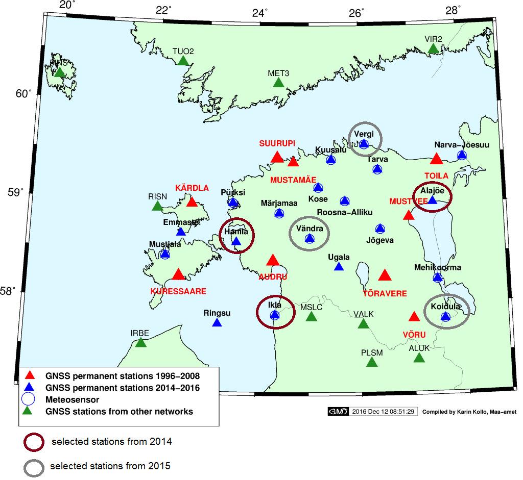
5 ESTPOS and NGN I order network
6 Campaign-wise GPS measurements 1997 and 2008 for I-order geodetic network The computations with Bernese, versions 4.2 and 5.0
7 ESTREF computations Since 2007 (week 1448) cumulative daily and weekly solutions Bernese software (versions 5.0 and 5.2) Guidelines for EPN and NKG Altogether ca 80 stations computed
8 Time series analysis TS from 7 CORS were analysed and horizontal and vertical uplift rates were derived The time-series were compiled using programs CATREF and CATS

9 Velocity from GNSS National geodetic network, I order CORS stations
10
11
12
13


 EST2013LU")
14 um=0,6*106 Pa s; lm 6,5*106 Pa s; LT=75 km GIA model for Fennoscandia, based on KL05 ice model (Kollo et al., 2016) NKG2005LU model (Ågren and Svensson, 2007) EST2013LU model (Kall et al., 2016)
15 Comparisons with models The observed displacements of geodetic points as well as velocity estimates of CORS were compared with the predictions latest PGR empirical models (e.g. NKG2005LU and EST2013 LU) GIA model WGRFPN meeting Copenhagen May 2014

16 Velocity from models (LU, GIA) Comparison with LU models Comparison with GIA model
17 Results In most cases good fit between the observations and models was found The higher discrepancies appeared in the East and South-East Estonia Noise in measurements (GNSS, levelling, TG, gravity) no observationdata from study area have been used in compilation of widespread ice and GIA models
18 References Ågren, J., Svensson, R. (2007). Postglacial Land Uplift Model and System Definition for the New Swedish Height System RH LMV-Rapport 2007:4, Lantmäteriet, Sweden. Kall, T., Liibusk, A., Wan, J., Raamat, R. (2016). Vertical crustal movements in Estonia determined from precise levellings and observations of the level of Lake Peipsi. Estonian Journal of Earth Sciences, 65 (1), Kollo, K., Spada, G., Vermeer, M. (2016). ( Studying Earth rheology using GNSS permanent stations and GIA modelling tools. Geophysica, 51, Liibusk, A., Ellmann, A., Kall, T., Kollo, K., Jürgenson, H. (2012). Verifying hydrodynamic levelling results through improved land uplift rates in West-Estonian Archipelago. COST ACTION ES0701 Improved Constrains on Models of Glacial Isostatic Adjustment. National & Kapodistrian University of Athens, March 19-22, Oja, T., Kollo, K., Pihlak, P. (2014). GIAst ja maapinna liikumistest Eestis GNSS-täppismõõtmiste valguses. Geodeet 44, Tartu. Acknowledgements: Priit Pihlk, Tõnis Oja

19 Thank you! Contact information: geoportaal.maaamet.ee
On the Use of Crustal Deformation Models. in the Management of ETRS89 Realizations in Fennoscandia
 On the Use of Crustal Deformation Models Presented at the FIG Working Week 2017, May 29 - June 2, 2017 in Helsinki, Finland in the Management of ETRS89 Realizations in Fennoscandia Martin Lidberg, Jonas
Kollo, Karin; Spada, Giorgio; Vermeer, Martin Studying earth rheology using GNSS permanent stations and GIA modelling tools
 Powered by TCPDF (www.tcpdf.org) This is an electronic reprint of the original article. This reprint may differ from the original in pagination and typographic detail. Kollo, Karin; Spada, Giorgio; Vermeer,
The BIFROST Project: 21 years of search for the true crustal deformation in Fennoscandia
 The BIFROST Project: 21 years of search for the true crustal deformation in Fennoscandia Martin Lidberg and Holger Steffen Lantmäteriet, Sweden Jan Johansson Chalmers University of Technology Halfdan Kierulf
A New Transformation Including Deformation Model for the Nordic and Baltic Countries
 A New Transformation Including Deformation Model for the Nordic and Baltic Countries Pasi HÄKLI, Finland, Martin LIDBERG, Sweden, Lotti JIVALL, Sweden, Torbjørn NØRBECH, Norway, Oddvar TANGEN, Norway,
NKG2016LU, an improved postglacial land uplift model over the Nordic-Baltic region
 NKG2016LU, an improved postglacial land uplift model over the Nordic-Baltic region Olav Vestøl, Jonas Ågren, Holger Steffen, Halfdan Kierulf, Martin Lidberg, Tõnis Oja, Andres Rüdja, Veikko Saaranen, Casper
A new transformation including deformation model for the Nordic. and Baltic countries
 A new transformation including deformation model for the Nordic Presented at the FIG Working Week 2017, May 29 - June 2, 2017 in Helsinki, Finland and Baltic countries P. Häkli, M. Lidberg, L. Jivall,
Geodetic Observing Systems: tools in observing the Glacial Isostatic Adjustment. Markku Poutanen Finnish Geodetic Institute
 Geodetic Observing Systems: tools in observing the Glacial Isostatic Adjustment Markku Poutanen Finnish Geodetic Institute Glacial Isostatic Adjustment Land uplift is just one consequence of the physical
The Difference between the N60 and BK77 Height Systems
 The Difference between the N60 and BK77 Height Systems Harli Jürgenson 1, Tarmo Kall 2 1 Institute of Land Surveying, Estonian Agricultural University Kreutzwaldi 5, Tartu 51014, Estonia, harli@eau.ee
A Strategic Plan for Geodesy in Sweden. Mikael Lilje Lars E. Engberg Geodesy Department Lantmäteriet Sweden
 A Strategic Plan for Geodesy in Sweden Mikael Lilje Lars E. Engberg Geodesy Department Lantmäteriet Sweden Our vision is to be able to meet Swedish society s needs for a homogeneous, sustainable geodetic
On the Management of Reference Frames in Sweden
 On the Management of Reference Frames in Sweden Christina KEMPE, Lotti JIVALL, Martin LIDBERG, Mikael LILJE, Sweden Key words: Reference frames, three-dimensional reference frame, height reference frame,
ONE YEAR WITH OUR ABSOLUTE GRAVIMETER
 ONE YEAR WITH OUR ABSOLUTE GRAVIMETER Mikael Lilje, Jonas Ågren, Andreas Engfeldt, Per-Anders Olsson Lantmäteriet, Sweden Introduction In Sweden, a new generation of reference systems has been introduced.
National Report of Sweden to the EUREF 2004 Symposium
 1 National Report of Sweden to the EUREF 2004 Symposium - geodetic activities at Lantmäteriet, the National Land Survey of Sweden Edited by Dan Norin Lantmäteriet, SE-801 82 Gävle, Sweden, dan.norin@lm.se
National Report of Sweden
 National Report of Sweden NKG geoid WG meeting Jonas Ågren jonas.agren@lm.se Jonas Ågren, 2010-03-09, Masala Summary of Swedish geoid activities Updated GNSS/levelling observations. New gravimetric quasigeoid
The NKG2008 GPS campaign final transformation results and a new common Nordic reference frame
 J. Geod. Sci. 2016; 6:1 33 Research Article Open Access P. Häkli*, M. Lidberg, L. Jivall, T. Nørbech, O. Tangen, M. Weber, P. Pihlak, I. Aleksejenko, and E. Paršeliūnas The NKG2008 GPS campaign final transformation
Vertical Motion from Satellite Altimetry and Tide gauges
 Vertical Motion from Satellite Altimetry and Tide gauges Alexander Braun, C.K. Shum and C.-Y. Kuo Byrd Polar Research Center and Laboratory for Space Geodesy and Remote Sensing, The Ohio State University,
GNSS Observations & Sea Level
 with contributions from: - Marta Marcos - Alvaro Santamaria - GNSS Observations & Sea Level Guy Wöppelmann gwoppelm@univ-lr.fr Outline: 1. Introduction 2. The importance of Vertical Land Motions 3. The
Title: Impact of Regional Reference Frame Definition on Geodynamic Interpretations
 Author manuscript, published in "Journal of Geodynamics 49, 3-4 (2010) 116" DOI : 10.1016/j.jog.2009.10.002 Title: Impact of Regional Reference Frame Definition on Geodynamic Interpretations Authors: J.
One Year with Our Absolute Gravimeter
 Mikael LILJE, Jonas ÅGREN, Andreas ENGFELDT and Per-Anders OLSSON, Sweden ABSTRACT In 2006 Lantmäteriet (the National Land Survey of Sweden) bought an absolute gravimeter (Micro-g Lacoste FG5) together
Specification of the Baltic Sea Chart Datum 2000 (BSCD2000)
") Specification of the Baltic Sea Chart Datum 2000 (BSCD2000) DRAFT by Jonas Ågren, Gunter Liebsch and Jyrki Mononen Version 3a, 2018-02-06 1. Definition The Baltic Sea Chart Datum 2000 (BSCD2000) is a geodetic
Specification of the Baltic Sea Chart Datum 2000 (BSCD2000) DRAFT by Jonas Ågren, Gunter Liebsch and Jyrki Mononen Version 3a, 2018-02-06 1. Definition The Baltic Sea Chart Datum 2000 (BSCD2000) is a geodetic
GGOS, ECGN and NGOS: Global and regional geodetic observing systems. Markku Poutanen Finish Geodetic Institute
 GGOS, ECGN and NGOS: Global and regional geodetic observing systems Markku Poutanen Finish Geodetic Institute Contents GGOS, ECGN, NGOS Why? How? Future? (geodesy) GGOS Structure GGOS Structure European
Vertical crustal movements in Estonia determined from precise levellings and observations of the level of Lake Peipsi
 Estonian Journal of Earth Sciences, 016, 65, 1, 7 47 doi: 10.3176/earth.016.03 Vertical crustal movements in Estonia determined from precise levellings and observations of the level of Lake Peipsi Tarmo
The New Swedish Height System RH 2000 and Geoid Model SWEN 05LR
 The New Swedish Height System RH 2000 and Geoid Model SWEN 05LR Runar SVENSSON, Jonas ÅGREN, Per-Anders OLSSON, Per-Ola ERIKSSON and Mikael Key words: height system, levelling, postglacial land uplift,
Aspects of Modelling Geographic Information in Geodesy and Geodynamics
 Department of Real Estate, Planning and Geoinformatics Aspects of Modelling Geographic Information in Geodesy and Geodynamics Karin Kollo DOCTORAL DISSERTATIONS Aalto University publication series DOCTORAL
Evaluation of the impact of atmospheric pressure loading modeling on GNSS data analysis
 Evaluation of the impact of atmospheric pressure loading modeling on GNSS data analysis R. Dach a, J. Böhm b, S. Lutz a, and P. Steigenberger c a Astronomical Institute, University of Bern, Bern, Switzerland
The Process of Changing from Local Systems into SWEREF 99
 The Process of Changing from Local Systems into SWEREF 99 A Challenge for Lantmäteriet and a Great Step for the Municipalities Anders Alfredsson, Bengt Andersson, Lars E. Engberg, Fredrik Dahlström, Tina
Evaluation of Transition to Updated Regional Q-geoid Model Janis KAMINSKIS
 Janis Kaminskis, Atis Vallis, Ineta Geipele, Iveta Stamure, Martins Reiniks, Una Krutova Evaluation of Transition to Updated Regional Q-geoid Model Janis KAMINSKIS Aim and tasks: The research aim is to
The International Terrestrial Reference System and ETRS89: Part I : General concepts
 The International Terrestrial Reference System and ETRS89: Part I : General concepts Zuheir ALTAMIMI Laboratoire de Recherche en Géodésie Institut national de l information géographique et forestière (IGN),
Special Bureau for Loading: Potential Role Versus Reality
 Special Bureau for Loading: Potential Role Versus Reality Hans-Peter Plag Nevada Bureau of Mines and Geology and Seismological Laboratory University of Nevada, Reno Special Bureau for Loading: Potential
Space-Geodetic Constraints on Glacial Isostatic Adjustment in Fennoscandia
 Space-Geodetic Constraints on Glacial Isostatic Adjustment in Fennoscandia G. A. Milne, 1 * J. L. Davis, 2 Jerry X. Mitrovica, 3 H.-G. Scherneck, 4 J. M. Johansson, 4 M. Vermeer, 5 H. Koivula 5 Analysis
New satellite mission for improving the Terrestrial Reference Frame: means and impacts
 Fourth Swarm science meeting and geodetic missions workshop ESA, 20-24 March 2017, Banff, Alberta, Canada New satellite mission for improving the Terrestrial Reference Frame: means and impacts Richard
HMK Swedish handbook in surveying and mapping
 HMK Swedish handbook in surveying and mapping A Alfredsson, J Sunna, C-G Persson TS07B - Standards and Recommended Practices for Positioning and Measurement, Paper no 7072 FIG Congress 2014 Engaging the
Modelling of the GIA-induced surface gravity change over Fennoscandia
 Modelling of the GIA-induced surface gravity change over Fennoscandia Per-Anders Olsson 1, Jonas Ågren 1, Hans-Georg Scherneck 2 June 15, 212 1 Geodetic Research Division, Lantmäteriet (Swedish mapping,
Case Study of Australia
 Case Study of Australia John Dawson, Geoscience Australia 1 Australia s Geodetic eco-system Geocentric Coordinates Observing Infrastructure Height Datum Geoid Models Tools Services Standards 2 Australia
Nordiska kommissionen för Geodesi Nordic Geodetic Commission
 Nordiska kommissionen för Geodesi Nordic Geodetic Commission Working Group for Geodynamics Minutes of the 30 th meeting of the Working Group for Geodynamics within the Nordic Geodetic Commission University
GGSP: Realisation of the Galileo Terrestrial Reference Frame
 Galileo Geodetic Service Provider Prototype GGSP: Realisation of the Galileo Terrestrial Reference Frame Wolfgang Söhne, Johannes Ihde Federal Agency for Cartography and Geodesy Gerd Gendt, Markus Rothacher
B6 Isostacy. B6.1 Airy and Pratt hypotheses. Geophysics 210 September 2008
 B6 Isostacy B6.1 Airy and Pratt hypotheses Himalayan peaks on the Tibet-Bhutan border In the 19 th century surveyors used plumblines and theodolites to map India. A plumb line was used when measuring the
A New Co-ordinate System for Sweden
 199 A New Co-ordinate System for Sweden M. LILJE, L. E. ENGBERG, B. ANDERSSON 1 Abstract Sweden introduced the three-dimensional reference frame SWEREF 99 in May 2001. It is based on the permanent GPS
National Report about geodetic work in Latvia
 National Report about geodetic work in Latvia EUREF 2007 London, 6th to 9th June 2007 J. Kaminskis, Department of Geodesy Latvian Geospatial Information Agency, Latvia E-mail: janis.kaminskis@lgia.gov.lv
A New Co-ordinate System for Sweden
 A New Co-ordinate System for Sweden Lars E. Engberg, Bengt Andersson, Lotti Jivall, Mikael Lilje, Bo-Gunnar Reit Lantmäteriet, Geodetic Department, SE-801 82 Gävle, Sweden e-mail: lars.e.engberg@lm.se,
On modelling of postglacial gravity change
 On modelling of postglacial gravity change PER-ANDERS OLSSON Department of Earth and Space Sciences Chalmers University of Technology Abstract Glacial isostatic adjustment (GIA) is the Earth's response
GPS time series and sea level
 GPS time series and sea level M. Poutanen 1, H. Koivula 1, M. Tervo 1,2, K. Kahma 3, M. Ollikainen 1, H. Virtanen 1 1 Finnish Geodetic Institute, 2 University of Helsinki, 3 Finnish Institute of Marine
Baltic Marine Environment Protection Commission
 Baltic Marine Environment Protection Commission Maritime Group Klaipeda, Lithuania, 23-25 November 2015 MARITIME 15-2015 Document title FAMOS Finalising Surveys for the Baltic Motorways of the Sea Code
High-Harmonic Geoid Signatures due to Glacial Isostatic Adjustment, Subduction and Seismic Deformation
 High-Harmonic Geoid Signatures due to Glacial Isostatic Adjustment, Subduction and Seismic Deformation L.L.A. Vermeersen (1), H. Schotman (1), M.-W. Jansen (1), R. Riva (1) and R. Sabadini (2) (1) DEOS,
Preparation for the ITRF2013. Zuheir Altamimi Xavier Collilieux Laurent Métivier IGN, France
 Preparation for the ITRF2013 Zuheir Altamimi Xavier Collilieux Laurent Métivier IGN, France 1 Outline Introduction Solicited solutions Analysis Strategy Preparation for the ITRF2013: Combination tests
GEORED Project: GNSS Geodesy Network for Geodynamics Research in Colombia, South America. Héctor Mora-Páez
 GEORED Project: GNSS Geodesy Network for Geodynamics Research in Colombia, South America. Héctor Mora-Páez Colombian Geological Survey UNAVCO SCIENCE MEETING Feb 27 March 1, 2012 Boulder, CO, TECTONIC
An Accuracy Assessment of Absolute Gravimetric Observations in Fennoscandia
 Nordic Journal of Surveying and Real Estate Research Volume 7, Number 1, 2010 Nordic Journal of Surveying and Real Estate Research 7:1 (2010) 7 14 submitted on March 12, 2009 revised on February 20, 2010
Modelling a future sea level change scenario affecting the spatial development in the Baltic Sea Region First results of the SEAREG project
 G. Schernewski & N. Löser (eds.): Managing the Baltic Sea. Coastline Reports 2 (2004), ISSN 0928-2734 S. 195-199 Modelling a future sea level change scenario affecting the spatial development in the Baltic
Deformation cycles of great subduction earthquakes in a viscoelastic Earth
 Deformation cycles of great subduction earthquakes in a viscoelastic Earth Kelin Wang Pacific Geoscience Centre, Geological Survey of Canada School of Earth and Ocean Science, University of Victoria????
Improving the geoid model for future GNSS-based navigation in the Baltic Sea
 Improving the geoid model for future GNSS-based navigation in the Baltic Sea Mirjam BILKER-KOIVULA, Jyrki MONONEN and Timo SAARI, Finland Christoph FÖRSTE, Franz BARTHELMES and Biao LU, Germany Jonas ÅGREN,
Towards unification of terrestrial gravity data sets in Estonia
 Estonian Journal of Earth Sciences, 2009, 58, 4, 229 245 doi: 10.3176/earth.2009.4.02 Towards unification of terrestrial gravity data sets in Estonia Artu Ellmann a, Tarmo All b, and Tõnis Oja c a Department
Summary of the 2012 Global Geophysical Fluid Center Workshop
 Summary of the 2012 Global Geophysical Fluid Center Workshop T. van Dam (Uni. Lux), J. Ray (NGS/NOAA), X. Collilieux (IGN) Introduction Review the history of the GGFC Discuss the 2012 Workshop Review recommendations
The Potential of High Resolution Satellite Interferometry for Monitoring Enhanced Oil Recovery
 The Potential of High Resolution Satellite Interferometry for Monitoring Enhanced Oil Recovery Urs Wegmüller a Lutz Petrat b Karsten Zimmermann c Issa al Quseimi d 1 Introduction Over the last years land
A New Co-ordinate System for Sweden
 Lars E. ENGBERG and Mikael LILJE, Sweden Key words: SWEREF 99, Map Projections, UTM. ABSTRACT Sweden introduced the three-dimensional reference frame SWEREF 99 in May 2001. It is based on the permanent
GEODETIC NETWORK OF SAUDI ARABIA AND FIDUCIAL STATIONS. GFN OF Saudi Arabia in Based on ITRF2000 Datum
 STUDIES OF TECTONIC MOVEMENTS IN SAUDI ARABIA USING CORS M. Al Rajhi, Ali Al Omar, R. Yanar, F. Kartal, K. Eren, SUBJECT TO TALKS BACKGROUND GEODETIC NETWORK OF SAUDI ARABIA AND FIDUCIAL STATIONS GFN OF
Tectonic deformations in Greece and the operation of HEPOS network
 Tectonic deformations in Greece and the operation of HEPOS network M. Gianniou KTIMATOLOGIO S.A. (Hellenic Cadastre) Abstract Today, networks of permanent reference stations are broadly used for the realization
Fusion of Geodesy and GIS at NOAA s National Geodetic Survey
 Fusion of Geodesy and GIS at NOAA s National Geodetic Survey Esri Survey Summit July 6-9, 2013 San Diego, CA Michael Dennis, RLS, PE michael.dennis@noaa.gov The Plan Background NGS Data Explorer New Datasheet
Calculation of Historical Shore Levels back to 500 A.D. in the Baltic Sea Area due to Postglacial Rebound
 1 Small Publications in Historical Geophysics No. 31 Calculation of Historical Shore Levels back to 500 A.D. in the Baltic Sea Area due to Postglacial Rebound Martin Ekman Summer Institute for Historical
The relation between gravity rate of change and vertical displacement in previously glaciated areas.
 The relation between gravity rate of change and vertical displacement in previously glaciated areas. Per-Anders Olsson 1,2, Glenn Milne 3, Hans-Georg Scherneck 2, Jonas Ågren 1 Submitted to Journal of
Constraints on Shallow Low-Viscosity Earth Layers from Future GOCE Data
 Constraints on Shallow Low-Viscosity Earth Layers from Future GOCE Data Hugo Schotman 1,2, Bert Vermeersen 2, Pieter Visser 2 1 2 3 rd International GOCE User Workshop, ESA Esrin, 7 November 2006 glacial-isostatic
EVRF2007 as Realization of the European Vertical Reference System
 EVRF2007 as Realization of the European Vertical Reference System M. SACHER 1, J. IHDE 2, G. LIEBSCH 1, J. MÄKINEN Abstract Since 1994 the IAG Sub-commission for Europe (EUREF) has enhanced the Unified
Constraints on Intra-Continental Strain Rates and Glacial Isostatic Adjustment from Thousands of GPS Velocities
 Constraints on Intra-Continental Strain Rates and Glacial Isostatic Adjustment from Thousands of GPS Velocities Corné Kreemer William Hammond & Geoffrey Blewitt Nevada Geodetic Laboratory, NV Bureau of
Evaluation of height network in Latvia
 Evaluation of height network in Latvia Kaminskis J. (,), Balodis J. (), Janpaule I. (,), Normand M. (,), Rubans A. (), Silabriedis G. (,), Zvirgzds J. (,) AFFILIATION: () Riga Technical University; ()
Recent postglacial rebound, gravity change and mantle flow in Fennoscandia
 Geophys. J. int. (1996) 126,229-234 Recent postglacial rebound, gravity change and mantle flow in Fennoscandia Martin Ekmanl and Jaakko Makinen2 'National Land Survey, Division of Geodetic Research, S-801
Subsidence Monitoring in Hampton Roads Using Satellites
 ODU Digital Commons July 29, 2016: The Latest in Sea Level Rise Science Hampton Roads Sea Level Rise/Flooding Adaptation Forum 7-29-2016 Subsidence Monitoring in Hampton Roads Using Satellites Ben Hamlington
South Pacific Sea Level and Climate Monitoring Project
 G E O S C I E N C E A U S T R A L I A South Pacific Sea Level and Climate Monitoring Project GPS Coordinate Time Series, 2007.0 to Manoj N. Deo, Guorong Hu, John Dawson and Minghai Jia Record 2012/34 GeoCat
DIFFERENTIAL INSAR STUDIES IN THE BOREAL FOREST ZONE IN FINLAND
 DIFFERENTIAL INSAR STUDIES IN THE BOREAL FOREST ZONE IN FINLAND Kirsi Karila (1,2), Mika Karjalainen (1), Juha Hyyppä (1) (1) Finnish Geodetic Institute, P.O. Box 15, FIN-02431 Masala, Finland, Email:
Constraints on Mantle Structure from Surface Observables
 MYRES I: Heat, Helium & Whole Mantle Convection Constraints on Mantle Structure from Surface Observables Magali Billen University of California, Davis Department of Geology The Goal Use observations of
Case Study of Japan: Crustal deformation monitoring with GNSS and InSAR
 Technical Seminar Reference Frame in Practice, Case Study of Japan: Crustal deformation monitoring with GNSS and InSAR Basara Miyahara miyahara-b96ip@milt.go.jp Geospatial Information Authority of Japan
Reference frames and positioning
 The APREF Project: an Improved Geodetic Infrastructure for Asia and the Pacific (4861) John Dawson (Australia), Graeme Blick (New Zealand), Manoj Deo, Guorong Hu and Gary Johnston (Australia) Reference
Monitoring Crustal Deformation in Satakunta Region
 Geophysica (2010), 46(1 2), 69 78 Monitoring Crustal Deformation in Satakunta Region Sonja Nyberg 1, Markku Poutanen 1, Ulla Kallio 1 and Joel Ahola 2 1 Finnish Geodetic Institute, Geodeetinrinne 2, 02430
Combining InSAR, Levelling and GNSS for the Estimation of 3D Surface Displacements
 Combining InSAR, Levelling and GNSS for the Estimation of 3D Surface Displacements Thomas Fuhrmann (1), Miguel Caro Cuenca (2), Freek van Leijen (3), Malte Westerhaus (1), Ramon Hanssen (3), Bernhard Heck
Strategy for the Realization of the International Height Reference System (IHRS)
") Deutsches Geodätisches Forschungsinstitut (DGFI-TUM) Technische Universität München Strategy for the Realization of the International Height Reference System (IHRS) Laura Sánchez 1, Johannes Ihde 2, Roland
Deutsches Geodätisches Forschungsinstitut (DGFI-TUM) Technische Universität München Strategy for the Realization of the International Height Reference System (IHRS) Laura Sánchez 1, Johannes Ihde 2, Roland
An Investigation of Celsius Pioneering Determination of the Fennoscandian Land Uplift Rate, and of his Mean Sea Level Mark
 1 Small Publications in Historical Geophysics No. 25 An Investigation of Celsius Pioneering Determination of the Fennoscandian Land Uplift Rate, and of his Mean Sea Level Mark Martin Ekman Summer Institute
CONTENTS 1. INTRODUCTION (STUDY AREA) 3. PROCESSING (CONVENTIAL& GPS) 4. ANALYSIS OF OUTCOMES 5. CONCLUSIONS 2. THE GCM-ITU NETWORK SURVEYING
 3. PROCESSING (CONVENTIAL& GPS) 4. ANALYSIS OF OUTCOMES 5. CONCLUSIONS 2. THE GCM-ITU NETWORK SURVEYING") INVESTIGATION OF THE DISPLACEMENTS FROM 1941 TO 2007 USING TERRESTRIAL AND GPS MEASUREMENTS ALONG THE WESTERN PART OF NORTH ANATOLIAN FAULT IN MARMARA REGION G. Akay 1 and H. Ozener 2,1 [1]{Bogazici University,
INVESTIGATION OF THE DISPLACEMENTS FROM 1941 TO 2007 USING TERRESTRIAL AND GPS MEASUREMENTS ALONG THE WESTERN PART OF NORTH ANATOLIAN FAULT IN MARMARA REGION G. Akay 1 and H. Ozener 2,1 [1]{Bogazici University,
Report to the Nordic Geodetic Commission, Working Group for Geodynamics
 Report to the Nordic Geodetic Commission, Working Group for Geodynamics The major profile of activities in Space Geodesy at Chalmers concerns atmosphere remote sensing using microwave radiometry, GNSS
GNSS-specific local effects at the Geodetic Observatory Wettzell
 GNSS-specific local effects at the Geodetic Observatory Wettzell Peter Steigenberger, Urs Hugentobler, Ralf Schmid Technische Universität München (TUM) Uwe Hessels, Thomas Klügel Bundesamt für Kartographie
GNSS METEOROLOGY AND WATER VAPOUR ESTIMATION IN TURKEY
 GNSS METEOROLOGY AND WATER VAPOUR ESTIMATION IN TURKEY DR. CETIN MEKIK ASSOC. PROF., THE DEPT. OF GEOMATICS ENGINEERING BULENT ECEVIT UNIVERSITY, ZONGULDAK/TURKEY GNSS4SWEC MC&WG Meeting, Varna, Bulgaria,
Realizing a geodetic reference frame using GNSS in the presence of crustal deformations: The case of Greece
 Realizing a geodetic reference frame using GNSS in the presence of crustal deformations: The case of Greece M. Gianniou National Cadastre and Mapping Agency S.A. Outline 1. Introduction 2. Deformation
The European height reference system and its realizations
 The European height reference system and its realizations Martina Sacher, Gunter Liebsch EUREF symposium 2015 Tutorial Height & Gravity June 02, Leipzig, Germany Contents 1. UELN-forerunner - Steps of
The Process of Changing from Local Systems into SWEREF 99
 The Process of Changing from Local Systems into SWEREF 99 A Challenge for Lantmäteriet and a Great Step for the Municipalities Anders Alfredsson, Bengt Andersson, Lars E. Engberg, Fredrik Dahlström, Tina
How GNSS CORS in Japan works for geodetic control and disaster mitigations
 ICG Working Group D Reference Frames, Timing and Applications How GNSS CORS in Japan works for geodetic control and disaster mitigations ICG11, Nov. 7-11, 2016, Sochi, Russia Hiromichi TSUJI Geodetic Observation
Present-day secular variations in the low-degree harmonics of the geopotential: Sensitivity analysis on spherically symmetric Earth models
 JOURNAL OF GEOPHYSICAL RESEARCH, VOL. 107, NO. B12, 2378, doi:10.1029/2001jb000696, 2002 Present-day secular variations in the low-degree harmonics of the geopotential: Sensitivity analysis on spherically
Geodynamic Pattern of the West Bohemia during the October 2008 Earthquake Swarm
 10th Czech-Polish Workshop on RECENT GEODYNAMICS OF THE SUDETEN AND ADJACENT AREAS Szklarska Poręba, November 5-7, 2009 Geodynamic Pattern of the West Bohemia during the October 2008 Earthquake Swarm Vladimír
Analysis of National Vertical Datum Using Tidal Gauge Bench Mark in KOREA
 Analysis of National Vertical Datum Using Tidal Gauge Bench Mark in KOREA Hasu YOON, YunSoo CHOI, Hungkyu LEE, MinChol ChANG, Yong HUH (Republic of KOREA) What s TBM? TBM(Tidal Bench Mark) means a national
The use of smooth piecewise algebraic approximation in the determination of vertical crustal movements in Eastern Canada
 The use of smooth piecewise algebraic approximation in the determination of vertical crustal movements in Eastern Canada Azadeh Koohzare, Petr Vaníče, Marcelo Santos Department of Geodesy and Geomatics
ESTIMATES OF HORIZONTAL DISPLACEMENTS ASSOCIATED WITH THE 1999 TAIWAN EARTHQUAKE
 ESTIMATES OF HORIZONTAL DISPLACEMENTS ASSOCIATED WITH THE 1999 TAIWAN EARTHQUAKE C. C. Chang Department of Surveying and Mapping Engineering Chung Cheng Institute of Technology, Taiwan, ROC ABSTRACT A
THREE SEASONAL BEHAVIOUR OF THE BALKAN PENINSULA GNSS PERMANENT STATIONS FROM GPS SOLUTIONS
 Доклади на Българската академия на науките Comptes rendus de l Académie bulgare des Sciences Tome 66, No 1, 2013 GEOPHYSIQUE Sismologie THREE SEASONAL BEHAVIOUR OF THE BALKAN PENINSULA GNSS PERMANENT STATIONS
Land Board, NW Services and SDI Tambet Tiits, FRICS
 Land Board, NW Services and SDI Tambet Tiits, FRICS 07.09.2016 200th anniversary of the Struve Geodetic Arc Friedrich Georg Wilhelm Struve and Carl Friedrich Tenner Struve Geodetic Arc The Struve Geodetic
Global & National Geodesy, GNSS Surveying & CORS Infrastructure
 Global & National Geodesy, GNSS Surveying & CORS Infrastructure Chris Rizos School of Surveying & Spatial Information Systems University of New South Wales, Sydney, Australia President-elect, International
Glacial isostatic adjustment of the British Isles: new constraints from GPS measurements of crustal motion
 Geophys. J. Int. (2009) 178, 14 22 doi: 10.1111/j.1365-246X.2008.04033.x GJI Geodesy, potential field and applied geophysics Glacial isostatic adjustment of the British Isles: new constraints from GPS
ON THE RELATION BETWEEN GPS STRAIN FIELD AND ACTIVE FAULTS IN THE EASTERN BALTIC REGION
 ON THE RELATION BETWEEN GPS STRAIN FIELD AND ACTIVE FAULTS IN THE EASTERN BALTIC REGION B.A. Assinovskaya 1, V.L. Gorshkov 2, N.V. Shcherbakova 2, N.M. Panas 1 1 Geophysical Service RAS, seismic station
Warkworth geodetic station as a potential GGOS core site in New Zealand
 "Launching the Next-Generation IVS Network Session 2: Correlators, Stations and Operations Centers. 7th IVS General Meeting March 5, 2012 Madrid, Spain Warkworth geodetic station as a potential GGOS core
The Impact of the 2010 Darfield (Canterbury) Earthquake on the Geodetic Infrastructure in New Zealand 1
 Earthquake on the Geodetic Infrastructure in New Zealand 1") The Impact of the 2010 Darfield (Canterbury) Earthquake on the Geodetic Infrastructure in New Zealand 1 Graeme BLICK, John BEAVAN, Chris CROOK, Nic DONNELLY Keywords: Darfield Earthquake, control, survey,
The Impact of the 2010 Darfield (Canterbury) Earthquake on the Geodetic Infrastructure in New Zealand 1 Graeme BLICK, John BEAVAN, Chris CROOK, Nic DONNELLY Keywords: Darfield Earthquake, control, survey,
Case study of Japan: Reference Frames in Practice
 Case study of Japan: Reference Frames in Practice Basara Miyahara and Koji Matsuo Sponsors: 1 Outline Introduction - Geodetic reference frame of Japan - GEONET : continuous GNSS observation system Geometric
STATISTICAL EVALUATION OF THE STABILITY OF VLBI, SLR, DORIS AND GPS STATIONS
 STATISTICAL EVALUATION OF THE STABILITY OF VLBI, SLR, DORIS AND GPS STATIONS K. Le Bail (1), O. de Viron (), M. Feissel-Vernier (3), (1) Institut Géographique National/LAREG, Marne La Vallée, France and
ISSN Technical Sciences
 ISSN 1505-4675 Technical Sciences 17(2) 2014 Biosystems Engineering Civil Engineering Environmental Engineering Geodesy and Cartography Information Technology Mechanical Engineering Production Engineering
Recent results based on continuous GPS observations of the GIA process in Fennoscandia from BIFROST
 Recent results based on continuous GPS observations of the GIA process in Fennoscandia from BIFROST Martin Lidberg a,b,*, Jan M. Johansson a,c, Hans-Georg Scherneck a, Glenn A. Milne d a Department of
Monitoring and Analysis
 Monitoring and Analysis of the Italian Permanent Network RDN of GNSS stations G. Farolfi Symposium EUREF 2010 Gävle, Sweden 2th - 5th june 1 Outlook Data and features of the RDN network Processing Strategy
MODELS OF VERTICAL MOVEMENTS OF THE EARTH CRUST SURFACE IN THE AREA OF POLAND DERIVED FROM LEVELING AND GNSS DATA
 Acta Geodyn. Geomater., Vol. 9, No. 3 (167), 331 337, 2012 MODELS OF VERTICAL MOVEMENTS OF THE EARTH CRUST SURFACE IN THE AREA OF POLAND DERIVED FROM LEVELING AND GNSS DATA Bernard KONTNY 1) * and Janusz
Vertical motions in Northern Victoria Land inferred from GPS: A comparison with a glacial isostatic adjustment model
 U.S. Geological Survey and The National Academies; USGS OF-2007-1047, Short Research Paper 073, doi:10.3133/of2007-1047.srp073 Vertical motions in Northern Victoria Land inferred from GPS: A comparison