14 Summer Training Course for Slope Land Disaster Reduction. Olgert Jaupaj, Albania. Brajesh Jaiswal, India
|
|
|
- Lesley White
- 5 years ago
- Views:
Transcription
1 14 Summer Training Course for Slope Land Disaster Reduction Olgert Jaupaj, Albania Brajesh Jaiswal, India
2 In natural systems, landslides are recognized as one of the most significant natural hazards in many areas throughout the world (Crozier and Glade, 2005). Landslide is a general term used to describe the mass movement of soil and rock downslope under gravitational influence. Landslides annually destroy or damage industrial or residential developments, forest and agricultural lands. They are often cause deaths, missing people, injuries and homelessness. They affect settlements, roads and other infrastructures, constituting a major problem worldwide.
3 Examples of large landslides around the world In 2006 Philippines (Leyte) rockslides and debris avalanche triggered by heavy rainfall killed 1100 people, 375 homes and a school were destroyed. In 2008 China(Sichuan) an earthquake ( 8 magnitude) have been recorded a total of landslides, inducing deaths In 2008 in Egypt (East Cairo) a destabilization due to man-made construction, a rockslide buried part of village destroying 150 houses, 107 deaths and 400 people missing. In 2009 Xiolin landslide and debris flow triggered by typhoon Morakot killed more the 400 people In 2010 Uganda(Bududa) debris flows triggered by heavy rainfall killed more than 400 people, and displaced In 2011 Brazil (Nova Friburgo RJ) with more than 1'000 landslides in a radius of 50 km, killed more than 1'000 people, dozens of injured and at least 20'0000 persons homeless and destroyed
4 Some examples of large landslides that have occurred in Albania in recent years In 1977 Moglice (Korce) a huge landslide triggered by heavy rainfall destroyed more than 50 house In 2008 Gjirokaster a destabilization due to man-made construction, a landslides killed 3 people, a building were destroyed In 2009 Synei (Kavaje) landslides triggered by heavy rainfall, 8 houses,roads and other infrastructures were destroyed were destroyed but fortunately no death In 2013 in Ngarcia (Gjirokaster) triggered by heavy rainfall, 11 houses, roads and other infrastucture were destroid but fortunately no death

5 Number of great natural catostrophes & associated economic losses worldwide
, Naga-Arakkan Mountain belt (Nagaland, Manipur, Mizoram and Tripura) 3.")
6 Landslide affected regions of India Western Himalayas (Uttarakhand, Himachal Pradesh and Jammu & Kashmir) 2. Eastern and N.E Himalayas (West Bengal, Sikkim and Arunachal Pradesh), Naga-Arakkan Mountain belt (Nagaland, Manipur, Mizoram and Tripura) 3. Western Ghats including Nilgiris (Maharashtra, Goa, Karnataka, Kerala & Tamil Nadu)
7 Landslide Facts Landslides rank third in terms of number of deaths due to natural disasters. Landslides kill 1 person / 100 Km²/ yr. Estimated average losses due to landslides in Himalaya costs > Rs. 550 crores / yr. & > 200 deaths.

8 Konkan Railway Track Subsidence

9 Landslide blocks Konkan Railway Track

10 Malpa Landslide India

11 Varunavat Landslide

12 Birahi Cloud Burst

 Tangni")

 Patalganga")


13 9 th Mile Landslide Sikkim (NH-39) B2 Landslide Sikkim (NH-39) Tangni Landslide Uttaranchal (NH-58) Kaliyasaur Landslide Uttaranchal (NH-58) Patalganga Landslide Uttaranchal (NH-58) Narendranagar Landslide Uttaranchal (NH-58)
14 Landslide of India Year Place Death 1998 Malpa, Pithoragarh district Okhimath, Rudraprayag district 2002 Ghansyali Tehsil, Tehri- Garhwal 2004 Chamoli District Malin, Pune 150
15 Landslide Assessment

16 Introduction

17 Study Area The study area is a part of Alaknanada Bhagirathi and Ganges basin which lies in the state of Uttarakhand, India extends with area of sq.km Lat/Long extend from 30 1'53.56"N, 78 15'24.27"E to 30 35'5.74"N, 79 35'43.56"E


18 Field Photographs A field view of overloading of hill slope at Devprayag A field view of overloaded slope by multistored building at Devprayag. Devprayag area as seen on satellite image.


19 A field view of rock fall zone further north of Chamoli. Joint openings of more than 8 cm are visible. Chamoli and surrounding area as viewed from satellite image. A field view of active slide zone in the immediate upslope of Birahi Ganga Bridge.


20 A field view of cracks developed in houses due to slow land subsidence in Saikot
21 Data and Software Used DATA USED ASTER 30m x 30m resolution DEM (Digital Elevation model) Lithology Map (1:50000) Weathering Map (1:50000) Road Map SOFTWARE USED The following given below software were used to process, create, manipulate and analyse the data for our study: ArcGIS 10 ERDAS IMAGINE 9.1 Google Earth
22 Elevation Map And distribution of Landslides A high elevation has high potential energy and thus is a causative factor for landslide. Th landslides in the study area ranges from 411m to 2843m with mean elevation of m. Most of the large to medium landslides were found to be occurred at elevation higher 1000 m. A large number of small landslides were found to be occurred at mean elevation of about 956 m.
23 Slope Map And distribution of Landslides Slope is most important causative factor of landslide. Steep slopes are more vulnerable to landslide while gentle slopes are stable. The slope for landslides varied from about 10 to upto about 63. Most of the landslides were found to be concentrated on steep slopes. About 59% of landslides were occurred on unstable slopes (30 and above).
24 Lithology Map and distribution of Landslide Study area has various lithological units having asymmetrical area distributions. First five major lithological units, covers most of the study area. Landslides number varied through these lithological units. Most of these landslides, about 74%, were concentrated on three major lithological units i.e to dark grey phyllite with slate, biotite schist with grey granite gneiss and sandstone with shale.
25 Distribution of Landslides on different Lithology and mean slope of Landslides
26 Distribution of Landslides among different Weathered zone Weathering in the study area varied from very high weathering to nil weathering and had five categories i.e Very high, High, Moderate, Low and Nil. 58% of the area is low weathered while about 36% of the area is high to moderately weathered. About half of the landslides were present in the low weathered zone. High and moderate weathered zone had about 45% of landslides. Rest were present in very high and Nil weathered zone.
27 Landslide relation with weathering
28 Proximity of landslides to road A significant correlation between identified landslides and proximity to road was observed. Almost 94% landslides were either on the road side or near the road (within 1km distance). It showed that most of the landslides were due to anthropogenic activity i.e due to road construction. Only 6% of landslides were occurred due to natural processes.

29 Spatio-temporal change of Kaliyasur Landslide
30 Kaliyasaur landslide is located on a sharp bend at a distance of 171 km from Badrinath between Rudraprayag and Srinagar at an altitude of 700 m near Kaliyasaur village. This landslide is repeatedly activated many times such as in 1952, 1963, 1965, 1969, 1970, 1971, 1972, 1984, and The rocks exposed on the slide face are the white and pink quartzite inter bedded with slate (Bhandari, 1987).


31
32 Discussion Increase in instability of slope is due to cutting slopes during road construction and heavy rainfall are major cause of landslides in mountainous areas. Three major lithological units found in the study area are fragile. Foliated structure found in these lithologies has tendency to slide and slope cutting or heavy rainfall could easily make slopes instable towards sliding. Lineaments such as fracture, joints, faults present in the rock structure, exhibits zone of weakness were present in large number in the study area. Though, there were large numbers of landslides within the vicinity of these lineaments, most of these landslides were along the roads.
33 Conclusion The study area is found to be highly prone to landslides. Weak lithologies, weak lineament zones, varied degree of physical and chemical weathering and road construction or widening are the major reasons behind the instability or vulnerability of steep slopes towards landslides
34 FUTURE WORK


35 Instrumentation & Monitoring of Landslide Wire Extensometers Inclinometer Rainguage Camra Control Station Piezometer


36 REAL TIME DATA Inclinometer Piezometer Extensometer Rainguage Monitoring Camra Remote Control Station
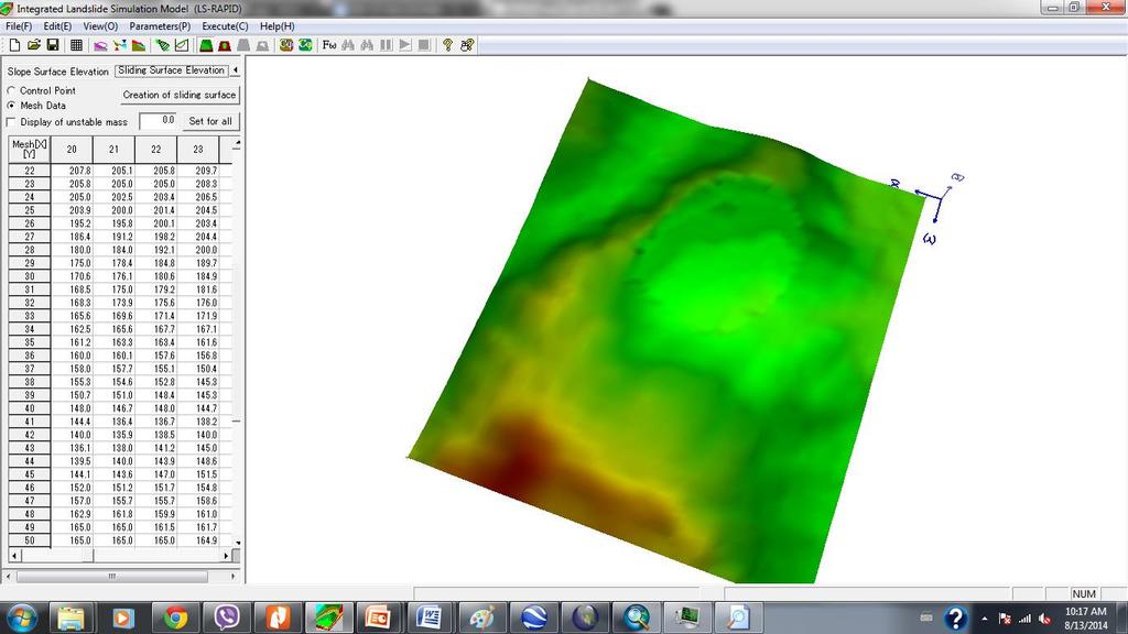
37 Landslide Gracia modelling using Ls_Rapid

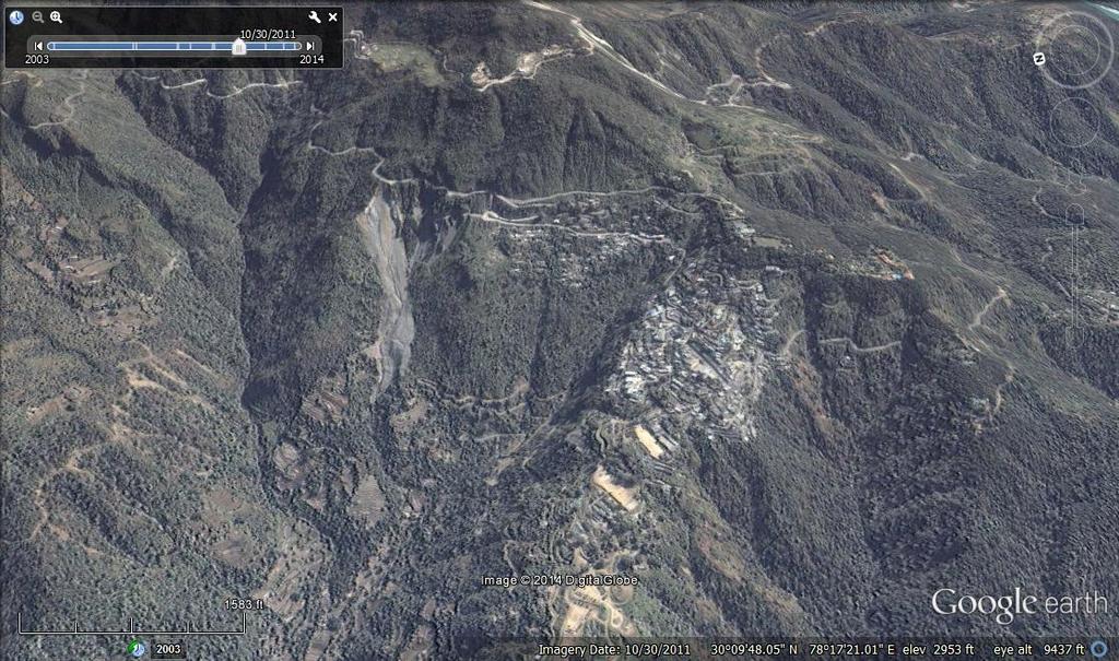
38 GEOGRAPHY OF STUDY AREA Geographically, the LANDSLIDE is located in south-western part of Albania Ngarcia Landslide occur in 25, March 2013 in Gracia village triggered by heavy rainfall, 11 houses, roads and other infrastucture were destroid but fortunately no death

39


40


41
42 FOTO KU TE JEM EDHE UNE NGA ATO FOTOT QE KEMI BERE BASHKE
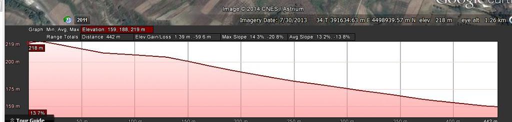
43 DATA PREPARATION Create the DEM of the study are from the topografic map using Arc_GIS Create the DEM of landslide are using Arc_GIS Export the DEM in ASCII and modifie for the LS-Rapid Soil parameters Other parameters (e.g., time, output, display)
44

45
46
47

48

49 謝謝
INTERNATIONAL JOURNAL OF GEOMATICS AND GEOSCIENCES Volume 1, No 1, 2010
 An Integrated Approach with GIS and Remote Sensing Technique for Landslide Hazard Zonation S.Evany Nithya 1 P. Rajesh Prasanna 2 1. Lecturer, 2. Assistant Professor Department of Civil Engineering, Anna
International Journal of Modern Trends in Engineering and Research e-issn No.: , Date: April, 2016
 International Journal of Modern Trends in Engineering and Research www.ijmter.com e-issn No.:2349-9745, Date: 28-30 April, 2016 Landslide Hazard Management Maps for Settlements in Yelwandi River Basin,
2014 Summer training course for slope land disaster reduction Taipei, Taiwan, Aug
 MINISTRY OF SCIENCE AND TECHNOLOGY HYDROTECH RESEARCH INSTITUTE MINISTRY OF NATURAL RESOURCES AND ENVIRONMENT VIETNAM INSTITUTE OF GEOSCIENCES AND MINERAL RESOURCES (VIGMR) 2014 Summer training course
LANDSLIDE HAZARD ZONATION MAPPING IN GOPESHWAR, PIPALKOTI AND NANDPRAYAG AREAS OF UTTARAKHAND
 IGC 2009, Guntur, INDIA LANDSLIDE HAZARD ZONATION MAPPING IN GOPESHWAR, PIPALKOTI AND NANDPRAYAG AREAS OF UTTARAKHAND P.K. Deshpande Department of Geology, Walchand College of Engineering, Sangli 416416,
Report on Disaster statistics of Nepal
 Report on Disaster statistics of Nepal Submitted by Altaf Rehman Submitted to Dr. Naveed Ahmed University of engineering and technology Peshawar Assignment 1 Section A Registration id 14PWCIV456 Page 1
Long Range Forecast Update for 2014 Southwest Monsoon Rainfall
 Earth System Science Organization (ESSO) Ministry of Earth Sciences (MoES) India Meteorological Department PRESS RELEASE New Delhi, 9 June 2014 Long Update for 2014 Southwest Monsoon Rainfall HIGHLIGHTS
BASIC DETAILS. Morphometric features for landslide zonation A case study for Ooty Mettupalayam highway
 BASIC DETAILS Paper reference number : MWF PN 121 Title of the paper Name of the Presenter Author affiliation Mailing address Email address : Extraction of Topographic and Morphometric features for landslide
Geo-Environmental Study of Kaliasaur Landslide in District Rudraprayag of Garhwal Himalaya, Uttarakhand, India
 International Journal of Humanities and Social Science Invention ISSN (Online): 2319 7722, ISSN (Print): 2319 7714 Volume 5 Issue 3 March. 2016 PP.07-13 Geo-Environmental Study of Kaliasaur Landslide in
ALL INDIA INSTALLED CAPACITY (IN MW) OF POWER STATIONS
 OF POWER STATIONS") Region Northern Region Western Region Southern Region Eastern Region North Eastern Region Islands ALL INDIA Figures at decimal may not tally due to rounding off ALL INDIA INSTALLED CAPACITY (IN MW) OF
Region Northern Region Western Region Southern Region Eastern Region North Eastern Region Islands ALL INDIA Figures at decimal may not tally due to rounding off ALL INDIA INSTALLED CAPACITY (IN MW) OF
Hydrological parameters Controls Vulnerable Zones in Calicut Nilambur Gudalur Ghat section, Gudalur, The Nilgiris, Tamil Nadu.
 International Journal of ChemTech Research CODEN (USA): IJCRGG ISSN: 0974-4290 Vol.9, No.03 pp 248-253, 2016 Hydrological parameters Controls Vulnerable Zones in Calicut Nilambur Gudalur Ghat section,
ALL INDIA INSTALLED CAPACITY (IN MW) OF POWER STATIONS
 OF POWER STATIONS") Region Northern Region Western Region Southern Region Eastern Region North Eastern Region Islands ALL INDIA Figures at decimal may not tally due to rounding off ALL INDIA INSTALLED CAPACITY (IN MW) OF
Region Northern Region Western Region Southern Region Eastern Region North Eastern Region Islands ALL INDIA Figures at decimal may not tally due to rounding off ALL INDIA INSTALLED CAPACITY (IN MW) OF
2014 Summer Training Courses on Slope Land Disaster Reduction Hydrotech Research Institute, National Taiwan University, Taiwan August 04-15, 2014
 Final Project Report 2014 Summer Training Courses on Slope Land Disaster Reduction Hydrotech Research Institute, National Taiwan University, Taiwan August 04-15, 2014 Landslides in Mt. Umyeon Susceptibility
ALL INDIA INSTALLED CAPACITY (IN MW) OF POWER STATIONS
 OF POWER STATIONS") Region Northern Region Western Region Southern Region Eastern Region North Eastern Region Islands ALL INDIA Figures at decimal may not tally due to rounding off ALL INDIA INSTALLED CAPACITY (IN MW) OF
Region Northern Region Western Region Southern Region Eastern Region North Eastern Region Islands ALL INDIA Figures at decimal may not tally due to rounding off ALL INDIA INSTALLED CAPACITY (IN MW) OF
Geographical location and climatic condition of the
 Geographical location and climatic condition of the study sites North eastern region of India is comprised of eight states namely; Arunachal Pradesh, Assam, Manipur, Meghalaya, Mizoram, Nagaland, Sikkim
ALL INDIA INSTALLED CAPACITY (IN MW) OF POWER STATIONS
 OF POWER STATIONS") Region Northern Region Western Region Southern Region Eastern Region North Eastern Region Islands ALL INDIA Figures at decimal may not tally due to rounding off ALL INDIA INSTALLED CAPACITY (IN MW) OF
Region Northern Region Western Region Southern Region Eastern Region North Eastern Region Islands ALL INDIA Figures at decimal may not tally due to rounding off ALL INDIA INSTALLED CAPACITY (IN MW) OF
Geospatial Approach for Delineation of Landslide Susceptible Areas in Karnaprayag, Chamoli district, Uttrakhand, India
 Geospatial Approach for Delineation of Landslide Susceptible Areas in Karnaprayag, Chamoli district, Uttrakhand, India Ajay Kumar Sharma & Anand Mohan Singh Overview Landslide - movement of a mass of rock,
LANDSLIDE HAZARD ZONATION IN AND AROUND KEDARNATH REGION AND ITS VALIDATION BASED ON REAL TIME KEDARNATH DISASTER USING GEOSPATIAL TECHNIQUES
 LANDSLIDE HAZARD ZONATION IN AND AROUND KEDARNATH REGION AND ITS VALIDATION BASED ON REAL TIME KEDARNATH DISASTER USING GEOSPATIAL TECHNIQUES Divya Uniyal 1,*, Saurabh Purohit 2, Sourabh Dangwal 1, Ashok
Outline. Remote Sensing, GIS and DEM Applications for Flood Monitoring. Introduction. Satellites and their Sensors used for Flood Mapping
 Outline Remote Sensing, GIS and DEM Applications for Flood Monitoring Prof. D. Nagesh Kumar Chairman, Centre for Earth Sciences Professor, Dept. of Civil Engg. Indian Institute of Science Bangalore 560
Earthquake hazards. Aims 1. To know how hazards are classified 2. To be able to explain how the hazards occur 3. To be able to rank order hazards
 Earthquake hazards Aims 1. To know how hazards are classified 2. To be able to explain how the hazards occur 3. To be able to rank order hazards Types of hazard Primary A direct result of the earthquake
Introduction. About the Author:
 Remote sensing and GIS for Landslide Hazard Mapping in India - A Review 1 Er. Balwinder Lallotra, 2 Dr. Bushra Zaman 1,2 Department of Civil Engineering, MM University, Sadopur, Ambala Abstract: Landslides
INTRODUCTION. Climate
 INTRODUCTION Climate Landslides are serious natural disasters in many parts of the world. Since the past 30 years, rainfall triggered landslides and debris flows had been one of the natural disasters of
Debris flow: categories, characteristics, hazard assessment, mitigation measures. Hariklia D. SKILODIMOU, George D. BATHRELLOS
 Debris flow: categories, characteristics, hazard assessment, mitigation measures Hariklia D. SKILODIMOU, George D. BATHRELLOS Natural hazards: physical phenomena, active in geological time capable of producing
ALL INDIA INSTALLED CAPACITY (IN MW) OF POWER STATIONS
 OF POWER STATIONS") Region Northern Region Western Region Southern Region Eastern Region North Eastern Region Islands ALL INDIA Figures at decimal may not tally due to rounding off ALL INDIA INSTALLED CAPACITY (IN MW) OF
Region Northern Region Western Region Southern Region Eastern Region North Eastern Region Islands ALL INDIA Figures at decimal may not tally due to rounding off ALL INDIA INSTALLED CAPACITY (IN MW) OF
Landslide Disasters in Uttarakhand: A Case of Landslide Susceptibility Zonation of Alaknanda Valley in Garhwal Himalaya
 Global Journal of Current Research Vol. 2 No. 1. 2013. Pp. 19-26 Copyright by CRDEEP. All Rights Reserved. Full Length Research Paper Landslide Disasters in Uttarakhand: A Case of Landslide Susceptibility
ALL INDIA WEATHER SUMMARY AND FORECAST BULLETIN
 Sunday 22 April 2018 NIGHT Time of Issue: 2000 hours IST ALL INDIA WEATHER SUMMARY AND FORECAST BULLETIN Significant Weather Features The ongoing fairly widespread rainfall activity with isolated thunder
Part 1: Weather Forecast Severe Weather Warnings (Source: IMD, Date: 1 st September, 2008)
") Sphere India Unified Response Strategy Situation report (India Floods 2008) 01 st September 2008 Part 1: Weather Forecast Severe Weather Warnings (Source: IMD, Date: 1 st September, 2008) HEAVY RAINFALL
Sphere India Unified Response Strategy Situation report (India Floods 2008) 01 st September 2008 Part 1: Weather Forecast Severe Weather Warnings (Source: IMD, Date: 1 st September, 2008) HEAVY RAINFALL
W E E K L Y MONSOON INSIGHT
 W E E K L Y MONSOON INSIGHT 08 th July 2016 Indian Monsoon Dynamics Recent Weather Development India received 35% surplus rainfall in the week ended 6 July with all regions recording above-normal rainfall
CSIR-Central Building Research Institute, Roorkee (UK)
") CSIR-Central Building Research Institute, Roorkee (UK) Introduction: Training programme on Control Measures for Landslides held during July 18-22, 2016 Landslides problem in hilly terrains are one of the
CSIR-Central Building Research Institute, Roorkee (UK) Introduction: Training programme on Control Measures for Landslides held during July 18-22, 2016 Landslides problem in hilly terrains are one of the
ALL INDIA WEATHER SUMMARY AND FORECAST BULLETIN
 Tuesday 08 May 2018 MID DAY Time of Issue: 1345 hours IST ALL INDIA WEATHER SUMMARY AND FORECAST BULLETIN Significant Weather Features Under the influence of the present Western Disturbance over Jammu
Mass Wasting. Revisit: Erosion, Transportation, and Deposition
 Mass Wasting Revisit: Erosion, Transportation, and Deposition While landslides are a normal part of erosion and surface processes, they can be very destructive to life and property! - Mass wasting: downslope
HYDROMET SERVICES FOR FLOOD FORECASTING. Dr. Surinder Kaur IMD, India, New Delhi
 HYDROMET SERVICES FOR FLOOD FORECASTING Dr. Surinder Kaur IMD, India, New Delhi Real Time Rainfall monitoring Hydromet Services Hyomet design Flood meteorological Services AWS=675 ARG=1289 Surface obs(dept)=
Landslides Management in Rural Roads of Pauri District (Uttarakhand): Challenges & Opportunities
: Challenges & Opportunities") Landslides Management in Rural Roads of Pauri District (Uttarakhand): Challenges & Opportunities Shakti Prakash 1 & V.V.S. Gulati 2 1 Corrosponding author, Environment Specialist, 2 Team Leader (Uttarakhand
Landslides Management in Rural Roads of Pauri District (Uttarakhand): Challenges & Opportunities Shakti Prakash 1 & V.V.S. Gulati 2 1 Corrosponding author, Environment Specialist, 2 Team Leader (Uttarakhand
ALL INDIA WEATHER SUMMARY AND FORECAST BULLETIN
 Saturday 21 April 2018 MORNING Time of Issue: 0800 hours IST ALL INDIA WEATHER SUMMARY AND FORECAST BULLETIN Significant Weather Features Isolated thunder squalls and hailstorms are very likely over Sub
UNIT 11 SOUTH ASIA SG 1 - PHYSICAL GEOGRAPHY & THE ENVIRONMENT
 UNIT 11 SOUTH ASIA SG 1 - PHYSICAL GEOGRAPHY & THE ENVIRONMENT I. PHYSICAL GEOGRAPHY TAKE OUT YOUR PHYSICAL MAP OF SOUTH ASIA A. The Himalayan Mountains form the northern boundary of the region (color
Mass Wasting. Mass Wasting. Earth s s External Processes
 1 Mass Wasting Presentation Modified from Instructor Resource Center on CD-ROM, Foundations of Earth Science, 4 th Edition, Lutgens & Tarbuck Mass Wasting 2 Down-slope movement of rock, loose material
STUDY AND SUGGESTIVE MEASURES OF LANDSLIDES ON PUNE MUMBAI ROUTE
 STUDY AND SUGGESTIVE MEASURES OF LANDSLIDES ON PUNE MUMBAI ROUTE G. D. Indurkar 1, U. R. Saharkar 2, H. H. Ahire 3, D.D. Kulkarni 4 1. PG. Students in Construction Mgt. Dr. D.Y. Patil Institute of Engineering
Key Finding: Long Term Trend During 2014: Rain in Indian Tradition Measuring Rain
 Chapter 34 RAINFALL Key Finding: Long Term Trend Despite of theories suggesting increase in rainfall in Asian Region due to global warming, no significant trend has been observed at all India level (confirmed
GG101 Lecture 22: Mass Wasting. Soil, debris, sediment, and broken rock is called regolith.
 GG101 Lecture 22: Mass Wasting Mass Wasting is the movement of rock and soil down a slope due to the force of gravity. Soil, debris, sediment, and broken rock is called regolith. Mass wasting creates broad
EIT-Japan Symposium 2011 on Human Security Engineering
 EIT-Japan Symposium 2011 on Human Security Engineering 2011 Disastrous Landslides at Khao Panom, Krabi, Thailand Suttisak Soralump Geotechnical Engineering Research and Development Center (GERD) Faculty
INTERNATIONAL JOURNAL OF GEOMATICS AND GEOSCIENCES Volume 2, No 2, 2011
 INTERNATIONAL JOURNAL OF GEOMATICS AND GEOSCIENCES Volume 2, No 2, 2011 Copyright 2010 All rights reserved Integrated Publishing services Research article ISSN 0976 4380 Geomorphological study of Atagad
Using Weather and Climate Information for Landslide Prevention and Mitigation
 Using Weather and Climate Information for Landslide Prevention and Mitigation Professor Roy C. Sidle Disaster Prevention Research Institute Kyoto University, Japan International Workshop on Climate and
Preparing Landslide Inventory Maps using Virtual Globes
 Introduction: A landslide is the movement of a mass of rock, debris, or earth down a slope, under the influence of gravity. Landslides can be caused by different phenomena, including intense or prolonged
Geography Class XI Fundamentals of Physical Geography Section A Total Periods : 140 Total Marks : 70. Periods Topic Subject Matter Geographical Skills
 Geography Class XI Fundamentals of Physical Geography Section A Total Periods : 140 Total Marks : 70 Sr. No. 01 Periods Topic Subject Matter Geographical Skills Nature and Scope Definition, nature, i)
Institute of Space and Earth Information Science & The Center for University and School Partnership, Faculty of Education, CUHK (Sponsored by QEF)
") 1 Landslides and Slope Stability in Hong Kong Introduction: There are many landslides in Hong Kong throughout the years. Some of these are disastrous, such as those occurring on Po Shan Road and in the
1 Landslides and Slope Stability in Hong Kong Introduction: There are many landslides in Hong Kong throughout the years. Some of these are disastrous, such as those occurring on Po Shan Road and in the
1. INTRODUCTION. EXAMPLE OF SECHILIENNE ROCKFALL (France)
") FORM OSE POST-GRADUATE COURSE Landslide vulnerability and risk 1 FORM OSE POST-GRADUATE COURSE Landslide vulnerability and risk 2 FORM OSE POST-GRADUATE COURSE Landslide vulnerability and risk 3 Christophe
FORM OSE POST-GRADUATE COURSE Landslide vulnerability and risk 1 FORM OSE POST-GRADUATE COURSE Landslide vulnerability and risk 2 FORM OSE POST-GRADUATE COURSE Landslide vulnerability and risk 3 Christophe
AFP Surveillance Bulletin - India Report for week 1, ending 5 January 2019
 Jan-18 Feb-18 Mar-18 Apr-18 May-18 Jun-18 Jul-18 Aug-18 Sep-18 Oct-18 Nov-18 Dec-18 Jan-19 Table 1: cases by month of paralysis onset, last 13 months State/UT's Total cases in cases as on week 1, cases
A Roundup of Recent Debris Flow Events in Taiwan
 2015 International Workshop on Typhoon and Flood APEC Experience Sharing on Hazardous Weather Events and Risk Management A Roundup of Recent Debris Flow Events in Taiwan Hsiao-Yuan(Samuel) Yin Ph.D. sammya@mail.swcb.gov.tw
Assessing Spatial Vulnerability for Landslide Threat in Hilly Areas of The Nilgiris, Tamil Nadu, India
 Assessing Spatial Vulnerability for Landslide Threat in Hilly Areas of The Nilgiris, Tamil Nadu, India by G.P.Ganapathy, Centre for Disaster Mitigation and Management, VIT University, Vellore 632014, India,
APPLICATION OF REMOTE SENSING & GIS ON LANDSLIDE HAZARD ZONE IDENTIFICATION & MANAGEMENT
 APPLICATION OF REMOTE SENSING & GIS ON LANDSLIDE HAZARD ZONE IDENTIFICATION & MANAGEMENT PRESENTED BY SUPRITI PRAMANIK M.TECH IN ENVIRONMENTAL SCIENCE AND TECHNOLOGY NIT,DURGAPUR 25-04-2015 1 INTRODUCTION
Natural Terrain Risk Management in Hong Kong
 Natural Terrain Risk Management in Hong Kong Nick Koor Senior Lecturer in Engineering Geology School of Earth and Environmental Sciences Slope failures in Hong Kong Man-made Slope Failure - 300 landslides
AN APPROACH TO THE CLASSIFICATION OF SLOPE MOVEMENTS
 Training/workshop on Earthquake Vulnerability and Multi-Hazard Risk Assessment: Geospatial Tools for Rehabilitation and Reconstruction Effort 13 31 March 2006, Islamabad, Pakistan AN APPROACH TO THE CLASSIFICATION
August 31, 2006 Embankment Failure Debris Flow at the Cascades Development Haywood County, North Carolina. Introduction. Findings
 August 31, 2006 Embankment Failure Debris Flow at the Cascades Development Haywood County, North Carolina Introduction North Carolina Geological Survey (NCGS) staff members visited the site of the August
CHAPTER 3 REMOTE SENSING & GIS STUDIES
 3.1 INTRODUCTION CHAPTER 3 REMOTE SENSING & GIS STUDIES Remote Sensing (RS) data can be considered an essential data source for the appraisal of natural environments as it provides valuable information
Georeferencing and Satellite Image Support: Lessons learned, Challenges and Opportunities
 Georeferencing and Satellite Image Support: Lessons learned, Challenges and Opportunities Shirish Ravan shirish.ravan@unoosa.org UN-SPIDER United Nations Office for Outer Space Affairs (UNOOSA) UN-SPIDER
Virtual Reality Modeling of Landslide for Alerting in Chiang Rai Area Banphot Nobaew 1 and Worasak Reangsirarak 2
 Virtual Reality Modeling of Landslide for Alerting in Chiang Rai Area Banphot Nobaew 1 and Worasak Reangsirarak 2 1 Banphot Nobaew MFU, Chiang Rai, Thailand 2 Worasak Reangsirarak MFU, Chiang Rai, Thailand
Grant 0299-NEP: Water Resources Project Preparatory Facility
 Document Produced under Grant Project Number: 45206 May 2016 Grant 0299-NEP: Water Resources Project Preparatory Facility Final Report Volume 3 East Rapti (1 of 9) Prepared by Pvt. Ltd. For Ministry of
Use of Geospatial data for disaster managements
 Use of Geospatial data for disaster managements Source: http://alertsystemsgroup.com Instructor : Professor Dr. Yuji Murayama Teaching Assistant : Manjula Ranagalage What is GIS? A powerful set of tools
Converse Consultants Geotechnical Engineering, Environmental & Groundwater Science, Inspection & Testing Services
 Converse Consultants Geotechnical Engineering, Environmental & Groundwater Science, Inspection & Testing Services July 27, 2017 Ms. Rebecca Mitchell Mt. San Antonio College Facilities Planning & Management
ANALYTICAL REPORTS ELEMENTARY EDUCATION IN RURAL INDIA
 2011-12 ANALYTICAL REPORTS ACKNOWLEDGEMENTS NUEPA is engaged in strengthening the educational management information system for more than ten years now. The process initiated in 42 districts across 7
N. K. Manglik Director
 N. K. Manglik Director Hydro-meteorological observations could be broadly defined as the scientific way for collection of flow data at a specific location along the river including selected meteorological
International Journal of Scientific Research and Reviews
 Research article Available online www.ijsrr.org ISSN: 2279 0543 International Journal of Scientific Research and Reviews Impact Assessment of LULC changes on Local Environment and Livelihood structure
DEVELOPMENT OF FLOOD HAZARD VULNERABILITY MAP FOR ALAPPUZHA DISTRICT
 DEVELOPMENT OF FLOOD HAZARD VULNERABILITY MAP FOR ALAPPUZHA DISTRICT Ciya Maria Roy 1, Elsa Manoj 2, Harsha Joy 3, Sarin Ravi 4, Abhinanda Roy 5 1,2,3,4 U.G. Student, Department of Civil Engineering, MITS
International Journal of Informative & Futuristic Research ISSN:
 www.ijifr.com Volume 4 Issue 9 May 2017 International Journal of Informative & Futuristic Research ISSN: 2347-1697 Landslide investigation in Mulshi Tehsil: A case study of Tamhini Ghat Paper ID IJIFR/V4/
International Journal of Intellectual Advancements and Research in Engineering Computations
 ISSN:2348-2079 Volume-5 Issue-2 International Journal of Intellectual Advancements and Research in Engineering Computations Agricultural land investigation and change detection in Coimbatore district by
GROUNDWATER CONFIGURATION IN THE UPPER CATCHMENT OF MEGHADRIGEDDA RESERVOIR, VISAKHAPATNAM DISTRICT, ANDHRA PRADESH
 GROUNDWATER CONFIGURATION IN THE UPPER CATCHMENT OF MEGHADRIGEDDA RESERVOIR, VISAKHAPATNAM DISTRICT, ANDHRA PRADESH Prof.P.Jagadeesara Rao Department of Geo-Engineering and Centre for Remote Sensing, College
RISK OF PRINCIPAL DISASTERS IN INDIA AND IMPACTS OF DISASTERS ON ECONOMIC DEVELOPMENT
 RISK OF PRINCIPAL DISASTERS IN INDIA AND IMPACTS OF DISASTERS ON ECONOMIC DEVELOPMENT At the Himachal Pradesh Institute of Public Administration Shimla 05. 05.2012 Improve Disaster Management with the
Beyond the Book. FOCUS Book
 FOCUS Book Suppose your city wants to build a new housing development on a steep slope outside town. Design a model to test whether the land is safe from the types of landslides you read about in this
CHAPTER 12 NATURAL DISASTERS
 CHAPTER 12 NATURAL DISASTERS In this chapter, you learn about the following: Natural calamities cyclones causes, effects and preventive measures Floods causes, affected areas, effects and control Land
The sketch map of field investigations in Wenchuan earthquake hit region, Chengdu City.
 The sketch map of field investigations in Wenchuan earthquake hit region, Chengdu City. 1 Environmental and Geological Condition 1.1 Geomorphology BaiSha River Basin is located in Dujiangyan County, and
THE UTARAKAHND FLOODS OF JUNE 2013 AND THE KEDARNATH TRAGEDY WHAT COULD HAVE HAPPENED?
 THE UTARAKAHND FLOODS OF JUNE 2013 AND THE KEDARNATH TRAGEDY WHAT COULD HAVE HAPPENED? GEOGRAPHICAL SET UP UTTARAKHAND STATE AREA - 53,484 sq.km FOREST AREA - 34,651 sq.km. (63.93%) HILLY AREA - 46,035
IDENTIFICATION OF LANDSLIDE-PRONE AREAS USING REMOTE SENSING TECHNIQUES
 5.1 IDENTIFICATION OF LANDSLIDE-PRONE AREAS USING REMOTE SENSING TECHNIQUES P.V. Seethapathi National Institute of Hydrology Jal Vigyan Bhawan, Roorkee-247 667, Uttarakhand Email: neriwalam@gwl.net.in
O.I.H. GOVERNMENT OF INDIA MINISTRY OF AGRICULTURE AND FARMERS WELFARE DEPARTMENT OF AGRICULTURE, COOPERATION AND FARMERS WELFARE
 O.I.H. GOVERNMENT OF INDIA MINISTRY OF AGRICULTURE AND FARMERS WELFARE DEPARTMENT OF AGRICULTURE, COOPERATION AND FARMERS WELFARE 185. SHRI DEVJI M. PATEL: LOK SABHA UNSTARRED QUESTION NO.185 TO BE ANSWERED
LANDSAT-TM IMAGES IN GEOLOGICAL MAPPING OF SURNAYA GAD AREA, DADELDHURA DISTRICT WEST NEPAL
 LANDSAT-TM IMAGES IN GEOLOGICAL MAPPING OF SURNAYA GAD AREA, DADELDHURA DISTRICT WEST NEPAL L. N. Rimal* A. K. Duvadi* S. P. Manandhar* *Department of Mines and Geology Lainchaur, Kathmandu, Nepal E-mail:
Paper presented in the Annual Meeting of Association of American Geographers, Las Vegas, USA, March 2009 ABSTRACT
 Paper presented in the Annual Meeting of Association of American Geographers, Las Vegas, USA, March 2009 ABSTRACT CHANGING GEOMORPHOLOGY OF THE KOSI RIVER SYSTEM IN THE INDIAN SUBCONTINENT Nupur Bose,
Team 09 Nguyen chau lan (Vietnam) Dilum Wannigasekara (Sri lanka)
 Dilum Wannigasekara (Sri lanka)") Team 09 Nguyen chau lan (Vietnam) Dilum Wannigasekara (Sri lanka) contents Part I: Landslide in Vietnam Part II: Case study of Landslide in sri lanka Part I: Introduction of Landslide in hoa binh province
Team 09 Nguyen chau lan (Vietnam) Dilum Wannigasekara (Sri lanka) contents Part I: Landslide in Vietnam Part II: Case study of Landslide in sri lanka Part I: Introduction of Landslide in hoa binh province
Disaster Management and Spatial Data An Experience of Sri Lanka for Joint project team meeting 2012
 Disaster Management and Spatial Data An Experience of Sri Lanka for Joint project team meeting 2012 1 by Padma Kumara Withana Provincial Surveyor General Uva Province 2 Out line ü Introduction ü Natural
Disaster Management in Bhutan
 ROYAL GOVERNMENT OF BHUTAN Disaster Management in Bhutan Tshering Wangchuk ROYAL GOVERNMENT OF BHUTAN EARTH FIRE WATER AIR ROYAL GOVERNMENT OF BHUTAN Presentation Outline Various Hazards in Bhutan Major
The financial and communal impact of a catastrophe instantiated by. volcanoes endlessly impact on lives and damage expensive infrastructure every
 Chapter 1 Introduction The financial and communal impact of a catastrophe instantiated by geophysical activity is significant. Landslides, subsidence, earthquakes and volcanoes endlessly impact on lives
LANDSLIDE SUSCEPTIBILITY MAPPING USING INFO VALUE METHOD BASED ON GIS
 LANDSLIDE SUSCEPTIBILITY MAPPING USING INFO VALUE METHOD BASED ON GIS ABSTRACT 1 Sonia Sharma, 2 Mitali Gupta and 3 Robin Mahajan 1,2,3 Assistant Professor, AP Goyal Shimla University Email: sonia23790@gmail.com
Landslide Susceptibility, Hazard, and Risk Assessment. Twin Hosea W. K. Advisor: Prof. C.T. Lee
 Landslide Susceptibility, Hazard, and Risk Assessment Twin Hosea W. K. Advisor: Prof. C.T. Lee Date: 2018/05/24 1 OUTLINE INTRODUCTION LANDSLIDE HAZARD ASSESSTMENT LOGISTIC REGRESSION IN LSA STUDY CASE
Assessment of the Incidence of Landslides Using Numerical Information
 PAPER Assessment of the Incidence of Landslides Using Numerical Information Atsushi HASEGAWA Takehiro OHTA, Dr. Sci. Assistant Senior Researcher, Senior Researcher, Laboratory Head, Geology Laboratory,
Landslides Zones of Nearby Areas of Malin Village, Pune District, Maharashtra Using GIS Techniques
 Landslides Zones of Nearby Areas of Malin Village, Pune District, Maharashtra Using GIS Techniques Pooja Gujarathi 1, S. J. Mane 2 1 Savitribai Phule Pune University, D. Y. Patil College of Engineering,
GEO The Åknes rock slope. Content. Dr. Vidar Kveldsvik NGI
 GEO 4180 The Åknes rock slope Dr. Vidar Kveldsvik NGI Content Background on large rock slides Triggers Stability analysis Risk mitigation (risk reduction) The Åknes rock slope 1 Background Landslides due
CHAPTER 4 CIRCULATION OF PUBLICATIONS
 Circulation of Publications 49 CHAPTER 4 CIRCULATION OF PUBLICATIONS 4.1. A total number of 29,599 publications furnished their circulation figures online for 2016-17 claiming a total circulation of 48,80,89,490
Pacific Catastrophe Risk Assessment And Financing Initiative
 Pacific Catastrophe Risk Assessment And Financing Initiative PALAU September is expected to incur, on average,.7 million USD per year in losses due to earthquakes and tropical cyclones. In the next 5 years,
Oktoberforum 2005: Case Histories in Engineering Geology and Geotechnical Engineering,, 4 th Oct. 2005, Petaling Jaya
 IEM-GSM Oktoberforum 2005: Case Histories in Engineering Geology and Geotechnical Engineering,, 4 th Oct. 2005, Petaling Jaya DISCONTINUITIES STUDY AND ROCK SLOPES STABILITY ANALYSIS FOR ROCK MASS AT DAMANSARA
Surface Processes on the Earth. Rocks, Weathering, Erosion and Soil
 Surface Processes on the Earth Rocks, Weathering, Erosion and Soil ROCKS AND ROCK CYCLE Rock types Three main types of rock Igneous Metamorphic Sedimentary Igneous Form when magma or lava cools and hardens
EMERGENCY WARNING SYSTEM PROCEDURES FOR DEBRIS FLOWS IN WESTERN OREGON
 EMERGENCY WARNING SYSTEM PROCEDURES FOR DEBRIS FLOWS IN WESTERN OREGON Updated: 12/03/2007 by the Oregon Department of Forestry and the Oregon Department of Geology and Mineral Industries Debris flows
Geoscientific Instrumentation in River Valley Projects
 J. Ind. Geophys. Union ( July 2008 ) Vol.12, No.3, pp.141-147 Geoscientific Instrumentation in River Valley Projects G.C.Pargaien Energy Infratech Private Limited, 145-146, Udyog Vihar, Phase IV, Gurgaon
Pacific Catastrophe Risk Assessment And Financing Initiative
 Pacific Catastrophe Risk Assessment And Financing Initiative TIMOR-LESTE September Timor-Leste is expected to incur, on average, 5.9 million USD per year in losses due to earthquakes and tropical cyclones.
GIS Application in Landslide Hazard Analysis An Example from the Shihmen Reservoir Catchment Area in Northern Taiwan
 GIS Application in Landslide Hazard Analysis An Example from the Shihmen Reservoir Catchment Area in Northern Taiwan Chyi-Tyi Lee Institute of Applied Geology, National Central University, No.300, Jungda
MULTI-HAZARD RISK ASSESSMENT AND DECISION MAKING
 MULTI-HAZARD RISK ASSESSMENT AND DECISION MAKING JULINDA KEÇI Epoka University Logo of the institution CONTENT: Introduction Multi Hazard Risks Multi-Hazard Risk Assessment Quantitative Assessment Event
Need of Proper Development in Hilly Urban Areas to Avoid
 Need of Proper Development in Hilly Urban Areas to Avoid Landslide Hazard Dr. Arvind Phukan, P.E. Cosultant/Former Professor of Civil Engineering University of Alaska, Anchorage, USA RI District Governor
DISASTER INFORMATION MANAGEMENT SYSTEM Sri Lanka
 DISASTER INFORMATION MANAGEMENT SYSTEM Sri Lanka 15 March 2016 - Partnership Meeting Global Centre for Disaster Statistics SRIMAL SAMANSIRI ASSISTANT DIRECTOR R&D DISASTER MANAGEMENT CENTRE Overview Country
Remote Sensing and GIS Application in Change Detection Study Using Multi Temporal Satellite
 Cloud Publications International Journal of Advanced Remote Sensing and GIS 2013, Volume 2, Issue 1, pp. 374-378, Article ID Tech-181 ISSN 2320-0243 Case Study Open Access Remote Sensing and GIS Application
Prediction of western disturbances and associated weather over Western Himalayas
 Prediction of western disturbances and associated weather over Western Himalayas H. R. Hatwar*, B. P. Yadav and Y. V. Rama Rao India Meteorological Department, Lodi Road, New Delhi 110 003, India Two cases
ENGINEERING EVALUATION OF THE STANLEY MINE ADVENTURE PARK AREA CLEAR CREEK COUNTY, COLORADO. Prepared for:
 braun Braun Consulting Engineers ENGINEERING EVALUATION OF THE STANLEY MINE ADVENTURE PARK AREA CLEAR CREEK COUNTY, COLORADO Prepared for: STANLEY MINES ADENTURE PARK 3375 W. POWERS CIRCLE LITTLETON, COLORADO
Mass Wasting. Requirements for Mass Wasting. Slope Stability. Geol 104: mass wasting
 Mass Wasting Movement of earth materials downslope, driven by Gravitational Forces. Landslides - general term for rock or soil movement. In U.S., on average, mass wasting causes 1 to 2 billion dollars
Post Independence Trends of Urbanization and Role of Small and Medium Towns in Maharashtra- A Geographical Analysis
 Post Independence Trends of Urbanization and Role of Small and Medium Towns in Maharashtra- A Geographical Analysis A careful and systematic study of the process of urbanization and related factors is
1 LAND USE PLANNING IN INDIA - RETROSPECT AND PROSPECT
 1 LAND USE PLANNING IN INDIA - RETROSPECT AND PROSPECT T. Haque National Fellow, National Centre for Agricultural Economics and Policy Research, New Delhi Ever since independence, India's planners and