DISASTER INFORMATION MANAGEMENT SYSTEM Sri Lanka
|
|
|
- Georgia Lane
- 6 years ago
- Views:
Transcription
1 DISASTER INFORMATION MANAGEMENT SYSTEM Sri Lanka 15 March Partnership Meeting Global Centre for Disaster Statistics SRIMAL SAMANSIRI ASSISTANT DIRECTOR R&D DISASTER MANAGEMENT CENTRE
2 Overview Country Arrangement for SFDRR and future Reporting Current practices of Disaster Statistics in SL Overview of National Risk Assessment Conclusions
3 Preparation for SFDRR in Sri Lanka Ministry of Disaster Management together with Disaster Management Centre and with cooperation of stakeholder agencies in the process of developing short and medium term action plan based on SFDRR Setting country level targets: Reduce Number of Affected People Deaths Economic losses Annual average economic loss 380 million US$ as per 2014, - Source: World Bank / GFDRR Annual average deaths (Hydrometeorological disasters approx. 125)
 and the UNDP Regional Centre in Bangkok (RCB) has initiated the development of a database on the past disaster incidents from 1974 to date.")
4 National Damage and Loss Database (Desinventar) The Disaster Management Centre (DMC) with technical and financial support from the Disaster Risk Management (DRM) programme of the United Nations Development Programme (UNDP) and the UNDP Regional Centre in Bangkok (RCB) has initiated the development of a database on the past disaster incidents from 1974 to date. The Disaster Information Management System is a sustainable arrangement within an institution for the systematic collection, documentation and analysis of data about losses caused by natural and man maid disasters. UNDP has handed over the operation in 2011 and thereafter, DMC is maintaining the database to date.

5 Data Sources Daily Situation Reports (EOC published Situation Reports) News Papers and other media reports Stakeholder organizations (Wildlife, Forest, Central Environment Authority etc)
6 Work Flaw Collect Daily data from DMC Sitreps and other sources Check data for incident basis Provisional entry of the records Record Validation And updates Update the online server


7 Reports
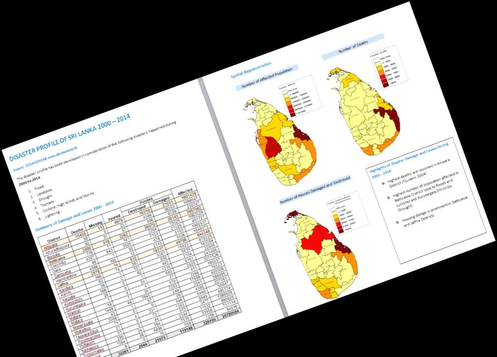
8 Disaster Profile of Sri Lanka
9 Hazards Considered Flood Landslide Drought Tsunami Cyclone, High Winds and Storms Lightning
10 Summary of Damage and Losses Houses District Deaths Missing Injured Destroyed Damaged Affected Ampara Anuradhapura Badulla Batticaloa Colombo Galle Gampaha Hambantota Jaffna Kalutara Kandy Kegalle Kilinochchi Kurunegala Mannar Matale Matara Moneragala Mullaitivu Nuwara Eliya Polonnaruwa Puttalam Ratnapura Trincomalee Vavuniya TOTAL


")

 Housing damge is prominent in")
11 Distribution of Damage & Losses Number of Affected Population Number of Deaths Number of Houses Damaged and Destroyed Highlights of Disaster Damage and Losses During Highest deaths are reported in Ampara District (Tsunami 2004) Highest number of population affected in Batticaloa District (due to floods and cyclone) and Kurunegala Ditrict (by Drought) Housing damge is prominent in Batticaloa and Jaffna Districts
12 Selection of District by Level of Damage ( Floods Houses District Deaths Injured Missing Destroyed Damaged Affected Ampara Batticaloa Colombo Gampaha Jaffna Kalutara Matara Ratnapura Drought District Affected Hambantota Kurunegala Moneragala Puttalam Ratnapura Batticaloa Landslide District Deaths Injured Missing Destroyed Houses Damaged Affected Badulla Kandy Kegalle Matale Nuwara Eliya Ratnapura
13 Selection of District by Level of Damage ( ) Cyclone / Strong Winds Houses District Deaths Injured Missing Destroyed Damaged Affected Anuradhapura Batticaloa Galle Kalutara Matara Nuwara Eliya Polonnaruwa Trincomalee Tsunami Houses District Deaths Injured Missing Destroyed Damaged Affected Ampara Batticaloa Galle Hambantota Jaffna Matara Lightning Houses District Deaths Injured Missing Destroyed Damaged Affected Anuradhapura Badulla Moneragala Ratnapura
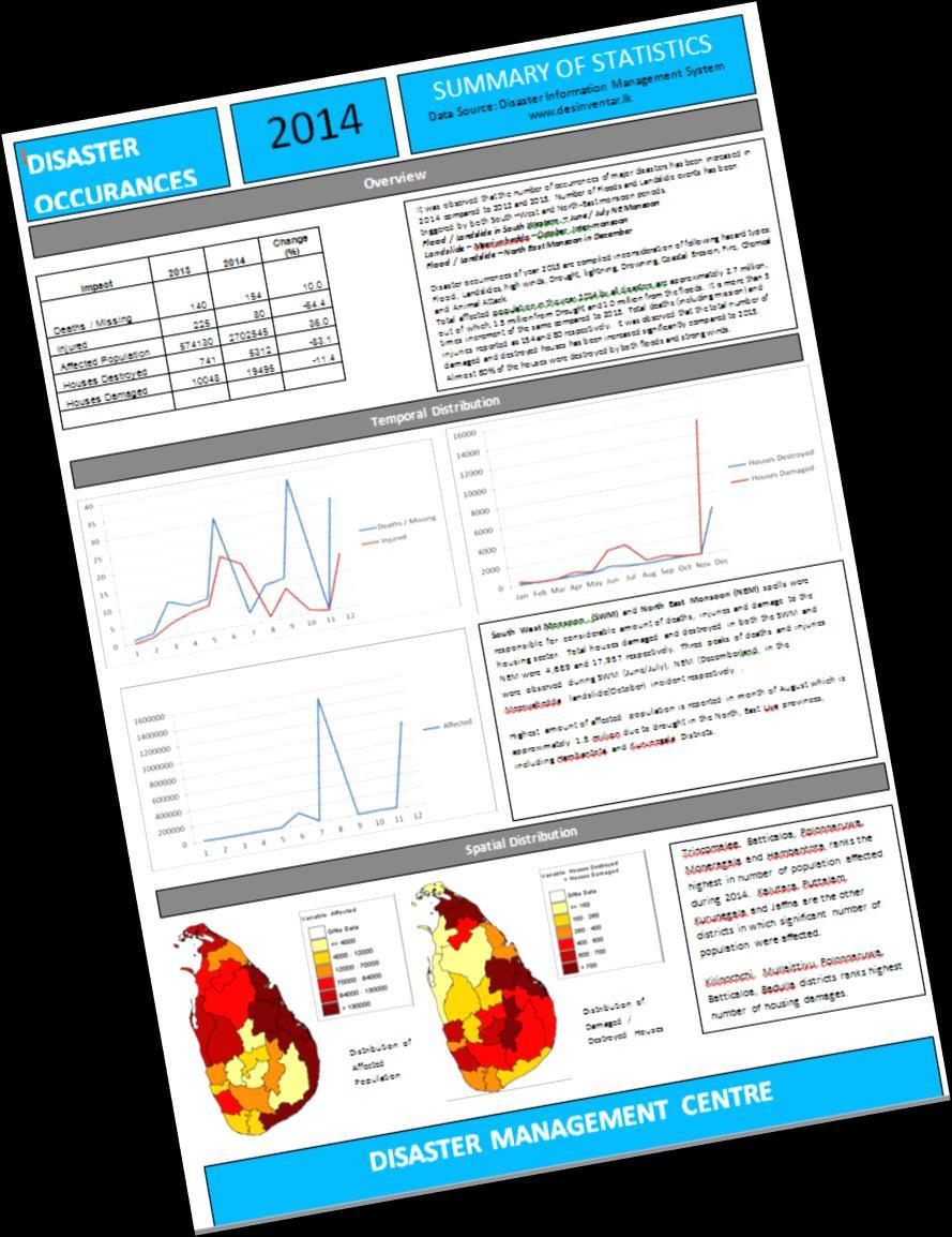
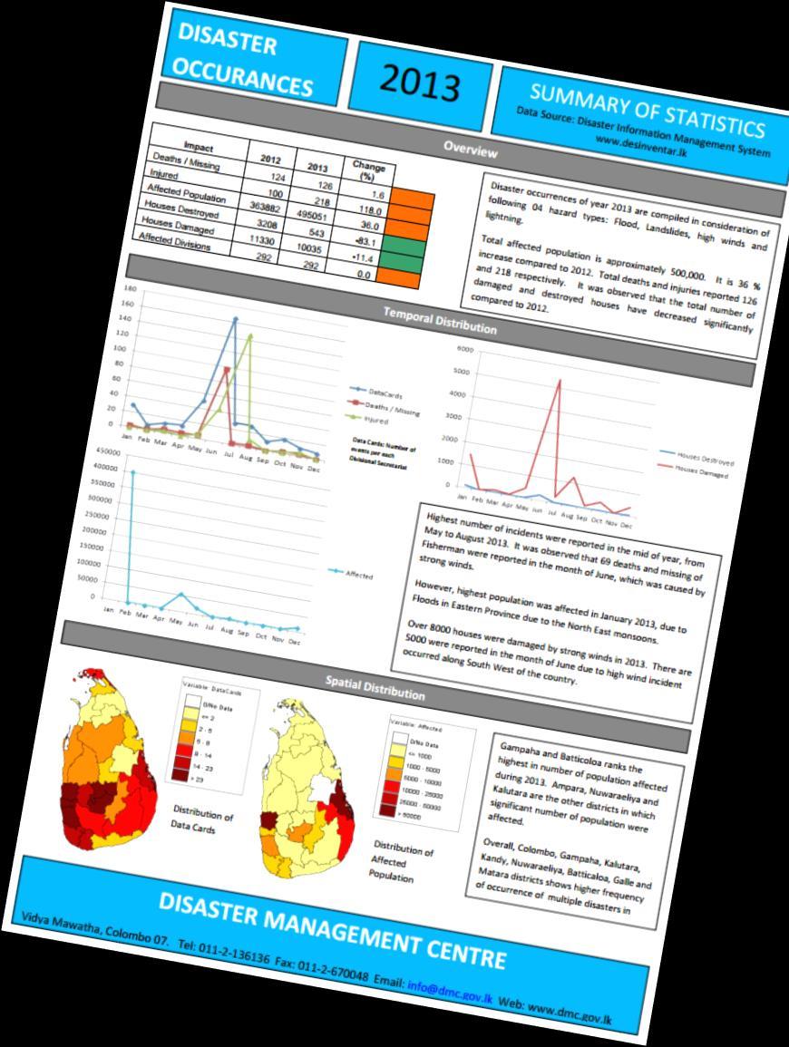
14 Annual Reports Impact Change (%) Deaths / Missing Injured Affected Population Houses Destroyed Houses Damaged Flood Landslides high winds Drought lightning Drowning Coastal Erosion Fire Chemical Animal Attack It was observed that the number of occurrences of major disasters has been increased in 2014 compared to 2012 and Number of Floods and Landslide events has been triggered by both South West and North-East monsoon periods. Flood / Landslide in South Western June / July NE Monsoon Landslide Meeriyabedda October Inter-monsoon Flood / Landslide North East Monsoon in December
15 Temporal Distribution 2014 South West Monsoon (SWM) and North East Monsoon (NEM) spells were responsible for considerable amount of deaths, injuries and damage to the housing sector. Total houses damaged and destroyed in both the SWM and NEM were 4,689 and 17,957 respectively. Three peaks of deaths and injuries were observed during SWM (June/July), NEM (December)and in the Meeriyabedda landslide(october) incident respectively. Highest amount of affected population is reported in month of August which is approximately 1.5 million due to drought in the North, East Uva provinces, including Hambantota and Kurunegala Districts.


16 Spatial Distribution 2014 Distribution of Affected Population Distribution of Damaged / Destroyed Houses Trincomalee, Batticaloa, Polonnaruwa, Moneragala and Hambantota ranks the highest in number of population affected during Kalutara, Puttalam, Kurunegala and Jaffna are the other districts in which significant number of population were affected. Kilinochchi, Mullaittivu, Polonnaruwa, Batticaloa, Badulla districts ranks highest number of housing damages.
17 Desinventar Users There is no mechanism to find who is using the database and generate statistics of users DMC provide free technical assistance on request Members of Parliament Local and foreign University students (Undergraduate / Master) Ministry of Finance Sri Lanka Land Reclamation Development Corporation Road Development Authority Urban Development Authority World Bank Local Insurance companies

18 Components of Hazard Profile Disaster Management Centre Floods Landslides Drought Cyclone Lightning United Nations Development Program Department of Irrigation National Building Research Organization Department of Agriculture Department of Meteorology Tsunami Sea Level Rise Storm Surge Coast Conservation Department Coastal Erosion

19 Best Practices Hazard Maps National hazard maps for 09 hazards are available at Tsunami Hazard - Batticaloa


20 Best Practices Hazard Maps Storm Surge Mannar Floods Kalu River


21 Tsunami Risk Vs Early Warning Towers Total Population exposed to Tsunami 128,027 Population at high risk 18743
22


23 Buildings might affected by Tsunami Building Exposed to Tsunami 20% 28% 52% High Moderate Low Tsunami Level # Buildings High 7854 Moderate 4280 Low 3052 Total buildings 32,000 Total tsunami affected buildings 15,000
24 New Project on National Risk Assessment Duration : 48 Months Risk Map Development for - Riverine Flood 7 River basins (world Bank -> 11) - Urban Flood 23 Urban Cities - Tsunami (entire coast) - Storm Surge (entire coast) - Drought - Strong Winds / Cyclone
 Walawe Ganga Basin (2596 sqkm) Kalu Ganga (2976 sqkm) Bolgoda Oya (366")
25 07 River Basins Mundeni Aru Basin (1475 sqkm) Kirindi (1230 sqkm) Mi Oya (113 sqkm) Yan Oya Basin (1782 sqkm) Walawe Ganga Basin (2596 sqkm) Kalu Ganga (2976 sqkm) Bolgoda Oya (366 sqkm)
26 Issues and Challenges 1. Only few indicators are updated at the moment 2. Difficult to obtain agricultural losses 3. Poor Participation of Stakeholder Agencies therefore, recording economic losses are difficult 4. Issues in Standardization It is high time to agree on basic terms of Affected, Victims, Partial Damage of Houses etc 5. User Friendliness 6. Issues with Database Schema 7. Database administration and software issues 8. No records available on users
27 Recommendations 1. Develop national policy / MoU for disaster damage and loss data collection 2. Develop standards and SoP for Data Collections 3. Re-Design of Database Schema 4. Consider possibility of improving Work Flaw from single source of entry to distributed data entry (Mobile App?) 5. Provide capacity building for Database Administrators, Data Providers and Users Groups
28 Thank You
Mainstream Space Technology in Implementing SFDRR - GPSTAR. Srimal Samansiri Disaster Management Centre Government of Sri Lanka
 Mainstream Space Technology in Implementing SFDRR - GPSTAR Srimal Samansiri Disaster Management Centre Government of Sri Lanka SFDRR Priority Actions Effective use of Space technology in SFDRR Priority
INTERNATIONAL JOURNAL OF GEOMATICS AND GEOSCIENCES Volume 4, No 1, 2013
 INTERNATIONAL JOURNAL OF GEOMATICS AND GEOSCIENCES Volume 4, No 1, 2013 Copyright by the authors - Licensee IPA- Under Creative Commons license 3.0 Research article ISSN 0976 4380 Geo-informatics application
Disaster Management and Spatial Data An Experience of Sri Lanka for Joint project team meeting 2012
 Disaster Management and Spatial Data An Experience of Sri Lanka for Joint project team meeting 2012 1 by Padma Kumara Withana Provincial Surveyor General Uva Province 2 Out line ü Introduction ü Natural
National Platform for Disaster Risk Reduction in Sri Lanka
 National Platform for Disaster Risk Reduction in Sri Lanka Eng.(Dr) Asiri Karaunwardena Director General / National Building Research Organization Ministry of Disaster Management Sri Lanka National Platform
Impacts of Disasters in Sri Lanka
 Impacts of Disasters in Sri Lanka 2016 i This publication is copyright, but may be reproduced without fee for teaching and reference purposes but not for sale. Formal permission is required from publisher
Sri Lanka Enhancing the Role of ICTs for Disaster Risk Management
 Workshop on ICT for Promoting Inclusive and Disaster Resilient Development Ulaanbaatar, Mongolia Sri Lanka Enhancing the Role of ICTs for Disaster Risk Management Kanchana Thudugala Programme Head, eservices
Temperature ( C) Map 1. Annual Average Temperatures Are Projected to Increase Dramatically by 2050
 Map 1. Annual Average Temperatures Are Projected to Increase Dramatically by 2050") CO UNT RY S NA P SHO T Sri Lanka s Hotspots The Impact of Temperature and Precipitation Changes on Living Standards Climate change is already a pressing issue for Sri Lanka. Temperatures have risen considerably
CO UNT RY S NA P SHO T Sri Lanka s Hotspots The Impact of Temperature and Precipitation Changes on Living Standards Climate change is already a pressing issue for Sri Lanka. Temperatures have risen considerably
Capacity Building Programme
 Capacity Building Programme 14-17 August 2012 Space Technology for improving Hazard Mapping in Sri Lanka An event organised as a follow up of the UN-SPIDER Technical Advisory Mission to Sri Lanka - 17-21
Climate Change in Sri Lanka: Threat, Vulnerability & Sectoral Opportunities
 Climate Change in Sri Lanka: Threat, Vulnerability & Sectoral Opportunities Ranjith Punyawardena, PhD Principal Agro-climatologist Department of Agriculture Peradeniya Greenhouse Effect Enhanced Source:
ColomboArts. Volume II Issue I Dynamic Trends of Intensity of Rainfall Extremes in Sri Lanka
 ColomboArts Volume II Issue I 2017 Dynamic Trends of Intensity of Rainfall Extremes in Sri Lanka R.M.S.S.Sanjeewani, 1 Lasantha Manawadu 2 1 Department of Transport and Logistics Management, University
Sentinel Asia System Operation for Disaster Management in Sri Lanka Major General L.B.R. Mark (Retd) Director General Disaster Management Centre
 Director General Disaster Management Centre") Sentinel Asia System Operation for Disaster Management in Sri Lanka Major General L.B.R. Mark (Retd) Director General Disaster Management Centre Government of Sri Lanka OUTLINE Background Disasters in
Sentinel Asia System Operation for Disaster Management in Sri Lanka Major General L.B.R. Mark (Retd) Director General Disaster Management Centre Government of Sri Lanka OUTLINE Background Disasters in
Ayubowan. Management (CBDRM) Community Based Disaster Risk. Towards Disaster Resilient Community Developed by Disaster Management Centre,
 Community Based Disaster Risk. Towards Disaster Resilient Community Developed by Disaster Management Centre,") Ayubowan Community Based Disaster Risk Management (CBDRM) Towards Disaster Resilient Community 5-20 Purpose of this activity To know the risks in community to prepare for future disasters To exchange knowledge
Ayubowan Community Based Disaster Risk Management (CBDRM) Towards Disaster Resilient Community 5-20 Purpose of this activity To know the risks in community to prepare for future disasters To exchange knowledge
Use of Geospatial data for disaster managements
 Use of Geospatial data for disaster managements Source: http://alertsystemsgroup.com Instructor : Professor Dr. Yuji Murayama Teaching Assistant : Manjula Ranagalage What is GIS? A powerful set of tools
FLOODS IN SOUTHWESTERN SRI LANKA IN MAY 2017
 FLOODS IN SOUTHWESTERN SRI LANKA IN MAY 2017 Foundation for Environment, Climate and Technology C/o Mahaweli Authority of Sri Lanka, Digana Village, Rajawella, Kandy, KY 20180, Sri Lanka Citation Lokuhetti,
The Cultural Geographer's Interest in Regions
 University of Nebraska - Lincoln DigitalCommons@University of Nebraska - Lincoln Geography Faculty Publications Geography Program (SNR) 2004 The Cultural Geographer's Interest in Regions Robert Stoddard
SEISMIC RISK ASSESSMENT IN ARMENIA
 SEISMIC RISK ASSESSMENT IN ARMENIA Hovhannes Khangeldyan Head of National Crisis Management Center Rescue Service Ministry of Emergency Situations of the Republic of Armenia Tokyo, 2016 ARMENIA: GEOGRAPHICAL
VALIDATION OF SPATIAL INTERPOLATION TECHNIQUES IN GIS
 VALIDATION OF SPATIAL INTERPOLATION TECHNIQUES IN GIS V.P.I.S. Wijeratne and L.Manawadu University of Colombo (UOC), Kumarathunga Munidasa Mawatha, Colombo 03, wijeratnesandamali@yahoo.com and lasan@geo.cmb.ac.lk
Long-range Forecast of Climate Change: Sri Lanka Future Scenario. G. B. Samarasinghe Director General of Meteorology
 Long-range Forecast of Climate Change: Sri Lanka Future Scenario G. B. Samarasinghe Director General of Meteorology 1 Line-up Global and Regional Future Scenarios Observed and Potential Impacts Observed
Chapter 2- Background of Urbanization and Remote Sensing of Urban Environment
 ... Chapter 2- Background of Urbanization and Remote Sensing of Urban Environment 2.0 Introduction This chapter discusses two conceptual bases relevant to this research. Urbanization pattern, distribution
GI Technology for Disaster Management
 GI Technology for Disaster Management 17 th ICC on the Regional Space Applications Programme for Sustainable Development (RESAP) 26 th Nov 2013 Bangkok Thailand Period and time of seasonal in thailand
PMMA Working Paper
 P O V E R T Y & E C O N O M I C P O L I C Y R E S E A R C H N E T W O R K PMMA Working Paper 2006-03 Identification of the Poor in Sri Lanka: Development of Composite Indicator and Regional Poverty Lines
Landslide Disaster Management in Sri Lanka and Nichola Oya as a Case study. Group 16 Gamini Jayathissa Udeni Nawagamuwa
 Landslide Disaster Management in Sri Lanka and Nichola Oya as a Case study Group 16 Gamini Jayathissa Udeni Nawagamuwa Taiwan Sri lanka >2582 mm, max >5000mm NE= Nov. to Feb 1750 2500 mm >2500 mm Central
3 rd Ministerial Conference and 9th Council meeting of the Regional Integrated Multi Hazard Early Warning Systems (RIMES)
") 3 rd Ministerial Conference and 9th Council meeting of the Regional Integrated Multi Hazard Early Warning Systems (RIMES) RIMES Capacity Building For Sri Lanka Department of Meteorology Sri Lanka Out Line
3 rd Ministerial Conference and 9th Council meeting of the Regional Integrated Multi Hazard Early Warning Systems (RIMES) RIMES Capacity Building For Sri Lanka Department of Meteorology Sri Lanka Out Line
Recent development of the National Hydro-Meteorological Service (NHMS) of Viet Nam for disaster risk reduction
 of Viet Nam for disaster risk reduction") Ministry of Natural Resources and Environment National Hydro-Meteorological Service Recent development of the National Hydro-Meteorological Service (NHMS) of Viet Nam for disaster risk reduction Tran Van
Ministry of Natural Resources and Environment National Hydro-Meteorological Service Recent development of the National Hydro-Meteorological Service (NHMS) of Viet Nam for disaster risk reduction Tran Van
Poverty in Sri Lanka is marked by spatial heterogeneity. The poverty headcount ratio. Poverty Maps in Sri Lanka. Policy Impacts and Lessons
 10412-12_Ch12.qxd 8/16/07 2:58 PM Page 225 12 Poverty Maps in Sri Lanka Policy Impacts and Lessons TARA VISHWANATH AND NOBUO YOSHIDA ACRONYMS AND ABBREVIATIONS DCS DS HIES Department of Census and Statistics
Disaster Risk Management in India. Kamal Kishore New Delhi, 27 October 2016
 Disaster Risk Management in India Kamal Kishore New Delhi, 27 October 2016 Hazard, Exposure and Vulnerability Disaster Prevention Mitigation Hurricane Matthew: Cuba & Haiti Emergency Response Coordination
2. 2 Methodology. 2.2 Data Screening
 ENGINEER - Vol. L, No. 02, pp. [39-48], 2017 The Institution of Engineers, Sri Lanka Changes in Rainfall in Sri Lanka during 1966 2015 K.L.A.A. Karunathilaka, H.K.V. Dabare and K.D.W. Nandalal Abstract:
Coastal Inundation Forecasting Demonstration Project CIFDP. Flood Forecasting Initiative-Advisory Group (FFI-AG 3), Geneva, 5-7 Dec, 2017
, Geneva, 5-7 Dec, 2017") Coastal Inundation Forecasting Demonstration Project CIFDP Flood Forecasting Initiative-Advisory Group (FFI-AG 3), Geneva, 5-7 Dec, 2017 Coastal Flooding & Vulnerable Populations Coastal populations are
Coastal Inundation Forecasting Demonstration Project CIFDP Flood Forecasting Initiative-Advisory Group (FFI-AG 3), Geneva, 5-7 Dec, 2017 Coastal Flooding & Vulnerable Populations Coastal populations are
5.2 IDENTIFICATION OF HAZARDS OF CONCERN
 5.2 IDENTIFICATION OF HAZARDS OF CONCERN 2016 HMP Update Changes The 2011 HMP hazard identification was presented in Section 3. For the 2016 HMP update, the hazard identification is presented in subsection
Bhutan Country Report for JPTM 2010 (July, 2010) Department of Disaster Management Ministry of Home & Cultural Affairs Royal Government of Bhutan
 Department of Disaster Management Ministry of Home & Cultural Affairs Royal Government of Bhutan") Bhutan Country Report for JPTM 2010 (July, 2010) Department of Disaster Management Ministry of Home & Cultural Affairs Royal Government of Bhutan 1 Contents of Presentation 1. Disaster Hazards and Underlying
Bhutan Country Report for JPTM 2010 (July, 2010) Department of Disaster Management Ministry of Home & Cultural Affairs Royal Government of Bhutan 1 Contents of Presentation 1. Disaster Hazards and Underlying
National Public Weather and Warning Services in the Swaziland Meteorological Service Dennis S.Mkhonta /
 National Public Weather and Warning Services in the Swaziland Meteorological Service Dennis S.Mkhonta dennis.mkhonta@gmail.com / dennis@swazimet.gov.sz Introduction Swaziland s geographical position exposes
Indian Ocean Tsunami Warning System: Example from the 12 th September 2007 Tsunami
 Indian Ocean Tsunami Warning System: Example from the 12 th September 2007 Tsunami Charitha Pattiaratchi 1 Professor of Coastal Oceanography, The University of Western Australia Email: chari.pattiaratchi@uwa.edu.au
March 2007 The Survey Department of Sri Lanka
 Contribution of Survey Department of Sri Lanka for Mitigation of Disasters in Sri Lanka K.A.U.N.Kasthuri Deputy Surveyor General (Information Technology) March 2007 The Survey Department of Sri Lanka 1
MOZAMBIQUE: Institutional Arrangements and Achievements
 UN-International Strategy for Disaster Reduction Global Platform for Disaster Risk Reduction- First Session MOZAMBIQUE: Institutional Arrangements and Achievements on Implementation of Hyogo Framework
Risk-based land use and spatial planning
 Risk-based land use and spatial planning Miho OHARA International Centre for Water Hazards and Risk Management (ICHARM) Public Works Research Institute PWRI), Japan Under the auspices of UNESCO Introduction
Smart use of Geographic Information System (GIS) platform for delivering weather information and nowcasting services
 platform for delivering weather information and nowcasting services") Smart use of Geographic Information System (GIS) platform for delivering weather information and nowcasting services C. K. Pan Hong Kong Observatory Hong Kong, China It is a world of beauty Source: Image
Smart use of Geographic Information System (GIS) platform for delivering weather information and nowcasting services C. K. Pan Hong Kong Observatory Hong Kong, China It is a world of beauty Source: Image
Republic of Mozambique
 Republic of Mozambique Second Expert's Symposium on Multi-Hazard Early Warning Systems with focus on the Role of National Meteorological and Hydrological Services 5-7 May 2009, Toulouse France 1. Background
MODELLING FROST RISK IN APPLE TREE, IRAN. Mohammad Rahimi
 WMO Regional Seminar on strategic Capacity Development of National Meteorological and Hydrological Services in RA II (Opportunity and Challenges in 21th century) Tashkent, Uzbekistan, 3-4 December 2008
Historical background
 Space Technology for Disaster Management in Sri Lanka: Country profile, national perspectives & vision. Professor Ranjith Premalal De Silva Vice Chancellor Uva Wellassa University of Sri Lanka October
Pacific Catastrophe Risk Assessment And Financing Initiative
 Pacific Catastrophe Risk Assessment And Financing Initiative TIMOR-LESTE September Timor-Leste is expected to incur, on average, 5.9 million USD per year in losses due to earthquakes and tropical cyclones.
The World Bank Cities and Climate Change (P123201)
") Public Disclosure Authorized AFRICA Mozambique Social, Urban, Rural and Resilience Global Practice Global Practice IBRD/IDA Investment Project Financing FY 2012 Seq No: 13 ARCHIVED on 17-May-2018 ISR31517
Public Disclosure Authorized AFRICA Mozambique Social, Urban, Rural and Resilience Global Practice Global Practice IBRD/IDA Investment Project Financing FY 2012 Seq No: 13 ARCHIVED on 17-May-2018 ISR31517
Activity Report 5th Monsoon Forum Colombo, Sri Lanka
 Activity Report 5th Monsoon Forum Colombo, Sri Lanka The 5 th Monsoon Forum, in Sri Lanka, was made possible through the United Nations Economic and Social Commission for Asia and the Pacific (UNESCAP)-supported
COUNTRY PRESENTATION ON MR JAYNAL ABEDIN JOINT SECRETARY ( WORKS & DEVELOPMENT ) MINISTRY OF DEFENCE
 MINISTRY OF DEFENCE") COUNTRY PRESENTATION ON By MR JAYNAL ABEDIN JOINT SECRETARY ( WORKS & DEVELOPMENT ) MINISTRY OF DEFENCE Bangladesh Geographical Location of Bangladesh Bangladesh Country at a Glance Physical Features 1,230
COUNTRY PRESENTATION ON By MR JAYNAL ABEDIN JOINT SECRETARY ( WORKS & DEVELOPMENT ) MINISTRY OF DEFENCE Bangladesh Geographical Location of Bangladesh Bangladesh Country at a Glance Physical Features 1,230
JCOMM-CHy Coastal Inundation Forecasting Demonstration Project (CIFDP)
") WMO World Meteorological Organization Working together in weather, climate and water JCOMM-CHy Coastal Inundation Forecasting Demonstration Project (CIFDP) Coastal Flooding & Vulnerable Populations Coastal
WMO World Meteorological Organization Working together in weather, climate and water JCOMM-CHy Coastal Inundation Forecasting Demonstration Project (CIFDP) Coastal Flooding & Vulnerable Populations Coastal
PRELIMINARY ASSESSMENT OF SURFACE WATER RESOURCES - A STUDY FROM DEDURU OYA BASIN OF SRI LANKA
 PRELIMINARY ASSESSMENT OF SURFACE WATER RESOURCES - A STUDY FROM DEDURU OYA BASIN OF SRI LANKA THUSHARA NAVODANI WICKRAMAARACHCHI Hydrologist, Water Resources Secretariat of Sri Lanka, Room 2-125, BMICH,
5.2 IDENTIFICATION OF HAZARDS OF CONCERN
 5.2 IDENTIFICATION OF HAZARDS OF CONCERN 2015 HMP Update Changes The 2010 HMP hazard identification was presented in Section 6. For the 2015 HMP update, the hazard identification is presented in subsection
A geographically weighted regression
 The Spatial Distribution of Poverty A geographically weighted regression by Introduction Problem How can we explore the spatial distribution of poverty and determine its correlates? This exercise examines
5.2 IDENTIFICATION OF HAZARDS OF CONCERN
 5.2 IDENTIFICATION OF HAZARDS OF CONCERN 2016 HMP Update Changes The 2011 HMP hazard identification was presented in Section 3. For the 2016 HMP update, the hazard identification is presented in subsection
Georeferencing and Satellite Image Support: Lessons learned, Challenges and Opportunities
 Georeferencing and Satellite Image Support: Lessons learned, Challenges and Opportunities Shirish Ravan shirish.ravan@unoosa.org UN-SPIDER United Nations Office for Outer Space Affairs (UNOOSA) UN-SPIDER
Geospatial Technologies for Resources Planning & Management
 Geospatial Technologies for Resources Planning & Management Lal Samarakoon, PhD Director, Geoinformatics Center Asian Institute of Technology, Thailand Content Geoinformatics for SDG Information Integration
Capacity Building in Applications of Remote Sensing and GIS for Disaster Management
 Capacity Building in Applications of Remote Sensing and GIS for Disaster Management M.K. Hazarika, L. Samarakoon, N. Senevirathne, J.S.M. Fowze and R. de Silva Project Researcher GeoInformatics Center
Norwegian spatial data infrastructure supporting disaster risk management Norwegian Mapping Authority
 Norwegian spatial data infrastructure supporting disaster risk management Norwegian Mapping Authority Arvid Lillethun, Norwegian Mapping Authority Land and Poverty 2018 Conference, World Bank 19.-23. March
Initiative. Country Risk Profile: papua new guinea. Better Risk Information for Smarter Investments PAPUA NEW GUINEA.
 Pacific Catastrophe Risk Assessment And Financing Initiative PAPUA NEW GUINEA September 211 Country Risk Profile: papua new is expected to incur, on average, 85 million USD per year in losses due to earthquakes
EARTH OBSERVATION SERVICES IN REPUBLIC OF MOLDOVA
 EARTH OBSERVATION SERVICES IN REPUBLIC OF MOLDOVA Vasile ALCAZ 1 Ion APOSTOL 2 1 Institute of Geology and Seismology Moldavian Academy of Sciences 2 Ministry of Environment and Natural Resources Republic
Flash Flood in Myanmar
 Flash Flood in Myanmar Presented by : Su Nandar Myint (Ms.) Staff Officer Emergency Operation Center Department of Disaster Management 26 th February 2018 Multi Hazard Early Warning Center, DMH Contents
Analytical Report. Drought in Sri Lanka January2017 ERCC Analytical Team and JRC Drought Team 26 January Map
 1. Map 2. Situation analysis Sri Lanka 1 is currently experiencing a severe drought. This drought situation has been caused by a severe lack of rainfall during the last second Inter-monsoon season (IM2)
Republic of Mozambique NATIONAL INSTITUTE OF METEOROLOGY
 Republic of Mozambique NATIONAL INSTITUTE OF METEOROLOGY Climate Information for Improvement of Water Related Disaster Risk Management Experience of Mozambique Mr. Anacleto Duvane National Institute of
RESAP Progress Report
 RESAP Progress Report December 2016 to October 2017 Presentation to the Twenty-first session of the Intergovernmental Consultative Committee on the Regional Space Applications Programme for Sustainable
STATUS OF HAZARD MAPS VULNERABILITY ASSESSMENTS AND DIGITAL MAPS
 JapanInternational Cooperation Agency STATUS OF HAZARD MAPS VULNERABILITY ASSESSMENTS AND DIGITAL MAPS ANGUILLA REPORT THE CARIBBEAN DISASTER EMERGENCY RESPONSE AGENCY () Table of Contents Page Preface
Disaster RISK Management : Bhutanese Scenario
 Disaster RISK Management : Bhutanese Scenario Expert Group Meeting (EGM) on Geo-referenced Information Systems for Disaster Risk Management (Geo-DRM) and sustaining the Community of Practice (COP), Bangkok,
NW Pacific and Japan Landfalling Typhoons in 2000
 NW Pacific and Japan Landfalling Typhoons in 2000 Pre-Season Forecast Issued 26th May, 2000 Produced under contract for TSUNAMI in collaboration with the UK Met. Office by Drs Paul Rockett, Mark Saunders
Impact of Cyclone Nargis
 Lessons Learnt from Nargis Recovery for the Next Disaster International Recovery Forum (2011) 12, JAN 2011, Kobe, Japan Home for over 100 national races. Profile of Myanmar The 2 nd largest country in
Workshop on Drought and Extreme Temperatures: Preparedness and Management for Sustainable Agriculture, Forestry and Fishery
 Workshop on Drought and Extreme Temperatures: Preparedness and Management for Sustainable Agriculture, Forestry and Fishery 16-17 Feb.2009, Beijing, China Modeling Apple Tree Bud burst time and frost risk
Md. Shahidul ISLAM Assistant Professor Department of Disaster Science and Management University of Dhaka, Bangladesh 12 December 2016 Nepal
 On the Spot Identification of Flood Inundation Depth from Gridded Data using GPS enabled Smartphone Application to help People fix Plinth Levels of their Houses Md. Shahidul ISLAM Assistant Professor Department
5.2. IDENTIFICATION OF NATURAL HAZARDS OF CONCERN
 5.2. IDENTIFICATION OF NATURAL HAZARDS OF CONCERN To provide a strong foundation for mitigation strategies considered in Sections 6 and 9, County considered a full range of natural hazards that could impact
Status & Challengers of Cook Islands GEO DRM. Cook Islands GEO S/GIS History
 Status & Challengers of Cook Islands GEO DRM By Patrick A. ARIOKA Planning & Advisory Officer EMERGENCY MANAGEMENT COOK ISLANDS Cook Islands GEO S/GIS History 1990 NZODA/MFAT trained by Landcare Research
Journey of supporting CSNs to establish Geo-DRM
 Regional Workshop on Geo-referenced Information Systems for Disaster Risk Management (Geo-DRM) 26-27 June 2014 Bangkok, Thailand Journey of supporting CSNs to establish Geo-DRM Keran Wang Chief, Space
Improving global coastal inundation forecasting WMO Panel, UR2014, London, 2 July 2014
 Improving global coastal inundation forecasting WMO Panel, UR2014, London, 2 July 2014 Cyclone Sidr, November 2007 Hurricane Katrina, 2005 Prof. Kevin Horsburgh Head of marine physics, UK National Oceanography
THE UNITED REPUBLIC OF TANZANIA MINISTRY OF WORKS, TRANSPORT AND COMMUNICATION TANZANIA METEOROLOGICAL AGENCY
 THE UNITED REPUBLIC OF TANZANIA MINISTRY OF WORKS, TRANSPORT AND COMMUNICATION TANZANIA METEOROLOGICAL AGENCY CLIMATE OUTLOOK FOR TANZANIA MARCH MAY, 2018 MASIKA RAINFALL SEASON Highlights for March May,
CLIMATE CHANGE ADAPTATION BY MEANS OF PUBLIC PRIVATE PARTNERSHIP TO ESTABLISH EARLY WARNING SYSTEM
 CLIMATE CHANGE ADAPTATION BY MEANS OF PUBLIC PRIVATE PARTNERSHIP TO ESTABLISH EARLY WARNING SYSTEM By: Dr Mamadou Lamine BAH, National Director Direction Nationale de la Meteorologie (DNM), Guinea President,
The Third UN-GGIM-AP Plenary Meeting. Use of Geospatial Information in Disaster and Coordination among NDMA and Relevant Organizations/Stakeholders
 The Third UN-GGIM-AP Plenary Meeting Use of Geospatial Information in Disaster and Coordination among NDMA and Relevant Organizations/Stakeholders Bali Indonesia 10 November 2014 Bernardus Wisnu Widjaja
Sri Lanka Strategic Cities Development Project (P130548)
") SOUTH ASIA Sri Lanka Social, Urban, Rural and Resilience Global Practice Global Practice IBRD/IDA Investment Project Financing FY 2014 Seq No: 10 ARCHIVED on 21-Dec-2018 ISR35436 Implementing Agencies:
SOUTH ASIA Sri Lanka Social, Urban, Rural and Resilience Global Practice Global Practice IBRD/IDA Investment Project Financing FY 2014 Seq No: 10 ARCHIVED on 21-Dec-2018 ISR35436 Implementing Agencies:
National Disaster Management Centre (NDMC) Republic of Maldives. Location
 Republic of Maldives. Location") National Disaster Management Centre (NDMC) Republic of Maldives Location Country Profile 1,190 islands. 198 Inhabited Islands. Total land area 300 sq km Islands range b/w 0.2 5 sq km Population approx.
National Disaster Management Centre (NDMC) Republic of Maldives Location Country Profile 1,190 islands. 198 Inhabited Islands. Total land area 300 sq km Islands range b/w 0.2 5 sq km Population approx.
Revealing the interaction between Society and Nature. DesInventar, disaster inventories for damage and loss assessment
 UNFCCC Regional expert meeting on a range approaches to address loss and damage associated with the adverse effects climate change, including impacts related to extreme weather events and slow onset events
United States Multi-Hazard Early Warning System
 United States Multi-Hazard Early Warning System Saving Lives Through Partnership Lynn Maximuk National Weather Service Director, Central Region Kansas City, Missouri America s s Weather Enterprise: Protecting
NATURAL HAZARD OCCURRENCE
 I.R.IRAN s NATURAL HAZARDS PROFILE Islamic Republic of Iran, situated in south-west Asia, covers an area of 1,648 million sq km with the population of 70,270,000 for the year 2006. Sixty percent of the
NEPAL: FCPF READINESS GRANT FCPFR - FOREST CARBON PARTNERSHIP FACILITY
 Assignment: TF094724 NEPAL: FCPF READINESS GRANT FCPFR - FOREST CARBON PARTNERSHIP FACILITY Task Team Leader: 00000240969 Approving Manager: 00000082671 - Abdelaziz Lagnaoui - Kseniya Lvovsky Summary Information
Bistandsprosjekter i Sørøst-Asia
 Bistandsprosjekter i Sørøst-Asia -Sikre liv og verdier Lars R. Hole, Hanneke Luijting, Tor Ivar Mathisen og Kristine Gjesdal September 2017 Norwegian Meteorological Institute Background Ministry of Foreign
DIPLOMA IN DISASTER MANAGEMENT. (Non-Semester) (With effect from the academic year )
 (With effect from the academic year )") DIPLOMA IN DISASTER MANAGEMENT (Non-Semester) (With effect from the academic year 2013-14) Eligibility for the Course Candidate should have passed the Higher Secondary Examination conducted by the Board
DIPLOMA IN DISASTER MANAGEMENT (Non-Semester) (With effect from the academic year 2013-14) Eligibility for the Course Candidate should have passed the Higher Secondary Examination conducted by the Board
EARLY WARNING IN SOUTHERN AFRICA:
 EARLY WARNING IN SOUTHERN AFRICA: Enhancing the Meteorological Early Warning System Eugene Poolman South African Weather Service OUTLINE OF PRESENTATION Impact of Climate Change Meteorological Early Warning
Team 09 Nguyen chau lan (Vietnam) Dilum Wannigasekara (Sri lanka)
 Dilum Wannigasekara (Sri lanka)") Team 09 Nguyen chau lan (Vietnam) Dilum Wannigasekara (Sri lanka) contents Part I: Landslide in Vietnam Part II: Case study of Landslide in sri lanka Part I: Introduction of Landslide in hoa binh province
Team 09 Nguyen chau lan (Vietnam) Dilum Wannigasekara (Sri lanka) contents Part I: Landslide in Vietnam Part II: Case study of Landslide in sri lanka Part I: Introduction of Landslide in hoa binh province
Roles of NGII in successful disaster management
 The Second UN-GGIM-AP Plenary Meeting Roles of NGII in successful disaster management Republic of Korea Teheran Iran 28 October 2013 Sanghoon Lee, Ph.D. NGII Outline Type of Disasters Occur in Korea Practical
INDONESIA IMPACT BASED FORECAST PROGRAM
 INDONESIA IMPACT BASED FORECAST PROGRAM Seoul, 19-21 November 2018 The 2nd Regional Workshop on Impact-based Forecasts in Asia Indonesia Agency for Meteorology Climatology and Geophysics (BMKG) A. Fachri
Pacific Catastrophe Risk Assessment And Financing Initiative
 Pacific Catastrophe Risk Assessment And Financing Initiative VANUATU September 211 Country Risk Profile: VANUATU is expected to incur, on average, 48 million USD per year in losses due to earthquakes and
Meteorological Hazards and Current Approach to Observing, Modelling and Predicting Severe Events in Sri Lanka
 Regional Workshop on Impact-based Forecasts in RA II (Asia) 7-9, November, 2017, Seoul, Republic of Korea Meteorological Hazards and Current Approach to Observing, Modelling and Predicting Severe Events
Progress Report. Flood Hazard Mapping in Thailand
 Progress Report Flood Hazard Mapping in Thailand Prepared By: Mr. PAITOON NAKTAE Chief of Safety Standard sub-beuro Disaster Prevention beuro Department of Disaster Prevention and Mitigation THAILAND E-mail:
Pacific Catastrophe Risk Assessment And Financing Initiative
 Pacific Catastrophe Risk Assessment And Financing Initiative PALAU September is expected to incur, on average,.7 million USD per year in losses due to earthquakes and tropical cyclones. In the next 5 years,
Global Forum on Electric Mobility & Conference on Sustainable Human Settlements
 Global Forum on Electric Mobility & Conference on Sustainable Human Settlements Sustainable Human Settlements in Coastal Cities Associated with events of Rio+20 Dr. Awni Behnam President International
Report on Disaster statistics of Nepal
 Report on Disaster statistics of Nepal Submitted by Altaf Rehman Submitted to Dr. Naveed Ahmed University of engineering and technology Peshawar Assignment 1 Section A Registration id 14PWCIV456 Page 1
Use of Climate information in Disaster Risk Management in Zimbabwe
 Use of Climate information in Disaster Risk Management in Zimbabwe WMO Regional Technical Meeting & User/CONOPS Workshop, 28 th October 2015 Lameck Betera Department of Civil Protection Institutional Arrangements
WMO Public Weather Services: Enhanced Communication Skills for Improved Service Delivery. by S.W. Muchemi (WMO)
") WMO Public Weather Services: Enhanced Communication Skills for Improved Service Delivery by S.W. Muchemi (WMO) Functions of the Public Weather Services (PWS) programme of WMO To strengthen the capabilities
WMO Public Weather Services: Enhanced Communication Skills for Improved Service Delivery by S.W. Muchemi (WMO) Functions of the Public Weather Services (PWS) programme of WMO To strengthen the capabilities
By Lillian Ntshwarisang Department of Meteorological Services Phone:
 By Lillian Ntshwarisang Department of Meteorological Services Phone: +267 3612200 Email: lntshwarisang@gov.bw/ lntshwarisang@gmail.com Introduction Mandate of DMS Function of the Department Services to
Cities and Climate Change (P123201)
") Public Disclosure Authorized AFRICA Mozambique Social, Urban, Rural and Resilience Global Practice Global Practice IBRD/IDA Investment Project Financing FY 2012 Seq No: 14 ARCHIVED on 04-Nov-2018 ISR33750
Public Disclosure Authorized AFRICA Mozambique Social, Urban, Rural and Resilience Global Practice Global Practice IBRD/IDA Investment Project Financing FY 2012 Seq No: 14 ARCHIVED on 04-Nov-2018 ISR33750
Uses of The Climate and Climate-related Hazard Information in The Adaptation Strategies for Development and Spatial Planning Assessments
 Uses of The Climate and Climate-related Hazard Information in The Adaptation Strategies for Development and Spatial Planning Assessments Wilmar Salim, ST., M. Reg. Dev., Ph.D. Yogyakarta Monday, March
Governance and Disaster Recovery: Lessons from the Field
 Governance and Disaster Recovery: Lessons from the Field Build it Better Leadership Forum Charlotte, North Carolina Gavin Smith, Ph.D., AICP Associate Research Professor University of North Carolina at
IDENTIFICATION OF HAZARDS OF CONCERN
 IDENTIFICATION OF HAZARDS OF CONCERN To provide a strong foundation for mitigation strategies considered in Section 6, the Village considered a full range of hazards that could impact the area and then
Overview and purposes of the meeting
 Overview and purposes of the meeting 1 Flash Floods vs. River Floods Riverine Flooding: is caused by heavy rainfall (and/or snow melt) over long periods e.g., days, leading to rising water levels and flooding
Establishment of WINDS Ground Station in Sri Lanka. By G.K.D. Amarawardena Additional Secretary Ministry of Disaster Management Sri Lanka
 Establishment of WINDS Ground Station in Sri Lanka By G.K.D. Amarawardena Additional Secretary Ministry of Disaster Management Sri Lanka Contents Background SAS Implementation Progress of WINDS establishment
UNIT 11 SOUTH ASIA SG 1 - PHYSICAL GEOGRAPHY & THE ENVIRONMENT
 UNIT 11 SOUTH ASIA SG 1 - PHYSICAL GEOGRAPHY & THE ENVIRONMENT I. PHYSICAL GEOGRAPHY TAKE OUT YOUR PHYSICAL MAP OF SOUTH ASIA A. The Himalayan Mountains form the northern boundary of the region (color
Applied Geoscience and Technology Division SOPAC. Joy Papao, Risk Information Systems Officer
 Joy Papao, Risk Information Systems Officer Secretariat of the Pacific Community SPC 22 Pacific Island States Head office in Noumea, New Caledonia 2 Regional offices (Pohnpei and Honiara) 600 staff 9 Technical