Landslide susceptibility and landslide hazard zoning in Wollongong. University of Wollongong, NSW, AUSTRALIA
|
|
|
- Hannah Wilson
- 5 years ago
- Views:
Transcription
 Civil, Mining, and Environmental Engineering")


1 Dr. Phil Flentje, Senior Research Fellow (Engineering Geologist) Civil, Mining, and Environmental Engineering Landslide susceptibility and landslide hazard zoning in Wollongong with co-authors Dr Daniel Palamara, Dr David Stirling and Professor Robin Chowdhury University of Wollongong, NSW, AUSTRALIA in collaboration with Industry Partners Wollongong City Council Roads and Traffic Authority Rail Corporation Phil Flentje LANDSLIDE Faculty PERFORMANCE of Engineering University of Wollongong HAZARD AND RISK MANAGEMENT GIS TECHNIQUES 1
2 Issues covered in this presentation UoW GIS-based Landslide Inventory 6 slides but I have to really zip through these Landslide Susceptibility Modelling Wollongong LGA Determining zones within the model grid Upgrade landslide Susceptibility to landslide Hazard zoning and if there is time UoW Sydney Basin wide Landslide Inventory and the preliminary SB Landslide Susceptibility zoning 2

3 UoW Illawarra Landslide Inventory Please refer to paper Developed from 1993, now quite mature but have perhaps 50% Field mapping at scale of 1:4000 and since with DGPS Comprehensive relational MS Access and ESRI Geo-database 3

4 UoW Illawarra Landslide Inventory Thirroul to Wombarra area Austinmer Cross Section ,000 M 1,500 2,000 4

5 So, what does this Inventory tell us about landsliding within Wollongong? In summary 586 landslide locations, 976 events includes first time movements, also multiple recurrences at some sites, some meaningful frequency info 586 landslides comprise 42 falls, 43 flows and 491 slides according to the Cruden and Varnes 1996 classifications system + a few unclassified In the 188 km 2 model area, 2.95% of the ground surface is affected by landslides to people killed 51 houses damaged, 29 destroyed Costs are very poorly understood - $18 million in remedial works, $550K in direct costs 5
6 Landslide Susceptibility Modeling Definition - quantitative or qualitative assessment of the classification, volume and spatial distribution of landslides in an area AGS 2007 (a) LI shows this must be done for independently for slide, fall and flow category landslides - the rest of this presentation focuses on slide category landslides Knowledge-based Data Mining modeling within GIS framework Datasets - Landslide Inventory, geology, vegetation, DEM and derivatives (slope, aspect, curvatures, Terrain Classification, Flow Accumulation and the Wetness Index) 6

7 Susceptibility knowledge based modeling process 7
8 Segment of the text file used for See5 Data Mining Data mining rule set generated for the training data ie, all landslide pixels plus an equal number of non landslide random pixels (65,295 points) X Y Z flowacc wetness ras10ma ras10ms plancur slide geology Vegetat profile curvatu geom_
9 3 example rules of 40 in rule set Rule 3: (22) flowacc <= 0 aspect > slope > 9.5 geology {3, 15, 16, 17} uowvege {6, 7} -> class 0 [0.958] Rule 24: (590/89) aspect <= 78.8 slope > 9.5 geology = 17 uowvege {4, 8, 16} -> class 1 [0.848] Rule 26: (1629/265) slope > 9.5 plaincur <= geology {3, 5, 6, 8-17, 19} uowvege {4, 8, 16} -> class 1 [0.837] Data Mining Rules Data Mining rules are generated to define all attributed training data in layman's terms DM is simply pattern recognition The Model contains a defined number of rules. Example rules are shown to the left. Each rule is ranked with a confidence factor, after repeated evaluation and validation, by the Laplace Ratio (nm+1)/(n+2) where n is the number of training cases that a specific rule correctly recognises, and m if it appears, is the number of cases that do not belong to the class predicted by the rule., i.e. rule x: (n, m). Class 0 is no landslide, 1 is landslide Rule sets then applied to Entire Model Area using ESRI Model Builder Confidence value as it aplies to each pixel is then mapped as susceptibility distribution 9
10 ESRI Model Builder used to re-apply rules within ArcGIS Sydney Basin Model shown 10
11 The resulting Susceptibility Grid Next screen Getting the model is one step in this process But how do you categorize or differentiate zones in this model Will these zones and stats be meaningful to compare to other zones in adjacent regions, let alone elsewhere nationally and internationally? If not, what s s the point? 11
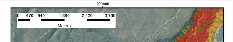

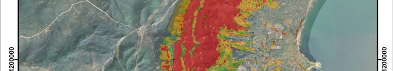
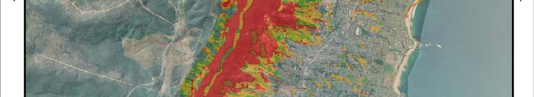

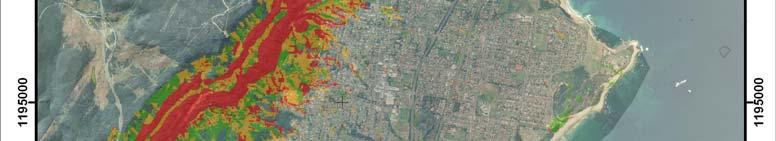

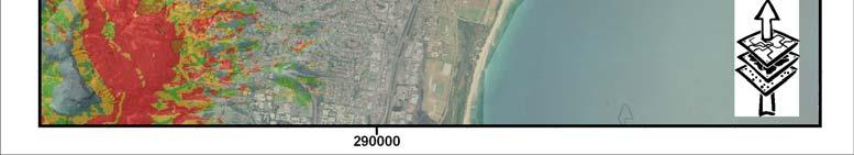

12 Susceptibility Zones 12
13 Post Modelling Analyses 13

14 Susceptibility Summary egend andslide Susceptibility Zones us. Class - % area affected by slides Very Low ~ 0.1% affected Low < 1% affected Moderate > 4% affected High > 8% affected Statistics of Susceptibility Model Area (188 Square Kms) 14
15 Hazard Description Regional Landslide Hazard Hazard - a condition with the potential to cause an undesirable consequence. Should also include location, volume, classification, velocity and probability Now that some reasonable zones have been defined this all becomes entirely possible, particularly with the aid of the GIS. Map Colour % of Zone affected by Slides (S) Zone area as % of Study Area (Sa) % of Total Slide Population in Hazard Zone (Sp) Landslide Annual Average Frequency ( ) Relative Susceptibility of Zone (S/Stotal) = Sr Relative Annual Likelihood (Hazard) (Sr/T) Maximum Landslide Volume (m³) Average Landslide Volume (m³) Weighted (volume) Hazard Very Low E E E-05 36,300 3, E-04 Low E E E-04 4,700 1, E-03 Moderate E E E-03 45,000 5, E-02 High E E E ,000 28, E-01 Landslide Count Volume Range (m 3 ) Count > > >1-3 4 > > > > > > > > > > > > Landslide Volume (m 3 ) Specific Frequency # of events Specific Frequency # of sites ( ) per site Count ( ) Landslide Count Landslide Profile Angle basedongisqueryof2mdem Normal Fit Number of data points used = 399 Average Profile Angle = 17 o S tanda rd Deviation = 8 o

16 Landslide Hazard Zoning 5.84E E E E-03 16


17 Extent of UoW Sydney Basin Landslide Inventory 2006 census shows 4.5 million people in Sydney Basin region UoW Landslide Inventory 586 landslides GA - National Landslide database within Sydney Basin excluding the Illawarra 130 Total 716 landslides Vegetation mapping at least Pittwater LGA also has 220 landslides + SCCG etc collaboration may add more 17
18 18

19 UoW composite National Landslide Inventory MRT 1584 landslides SW Victorian landslides GA s Australian LI 492 landslides Wollongong UoW LI 586 Warragamba Area from S. Greene PhD in SA & hopefully Pittwater Council 223 & possibly even others from wider SCCG ~ roughly 4987 landslides nationally that we know about ~ 4700 are on the eastern seaboard and Tasmania Doesn t include many in Camden Picton Area, Alpine Regions, Parwan Valley and Shire of Yarra Ranges in Victoria etc Recent geomorphic photo interpretation in SW Victoria has identified almost 10,000 areas 19of instability
20 Conclusions The base Landslide Inventory data is the essential first step in this type of work and its compilation requires sound and thorough engineering geological mapping there is no substitute for this! Repeat, no substitute! ONLY if the LI is comprehensive is this type of modeling possible Knowledge based Data Mining is a sound functional technique to aid development of landslide Susceptibility and Hazard zoning. Proven for high resolution, large, regional perhaps even Australia wide applications GIS techniques are only a tool to aid balanced decision making 20
Phil Flentje. in collaboration with Industry Partners Wollongong City Council Roads and Traffic Authority Rail Corporation HAZARD AND RISK
 Dr. Phil Flentje, Senior Research Fellow (Engineering Geologist) Civil, Mining, and Environmental Engineering email: pflentje@uow.edu.au GIS-based Landslide Inventory, Susceptibility and Hazard zoning
Practical reliability approach to urban slope stability
 University of Wollongong Research Online Faculty of Engineering - Papers (Archive) Faculty of Engineering and Information Sciences 2011 Practical reliability approach to urban slope stability R. Chowdhury
Quantitative landslide hazard assessment in an urban area
 University of Wollongong Research Online Faculty of Engineering and Information Sciences - Papers: Part A Faculty of Engineering and Information Sciences 1999 Quantitative landslide hazard assessment in
Landslide Susceptibility and Hazard derived from a Landslide Inventory using Data Mining an Australian case study
 University of Wollongong Research Online Faculty of Engineering - Papers (Archive) Faculty of Engineering and Information Sciences 2007 Landslide Susceptibility and Hazard derived from a Landslide Inventory
Slope instability, hazard and risk associated with a rainstorm event - a case study
 University of Wollongong Research Online Faculty of Engineering and Information Sciences - Papers: Part A Faculty of Engineering and Information Sciences 2000 Slope instability, hazard and risk associated
University of Wollongong. Research Online
 University of Wollongong Research Online Faculty of Engineering - Papers (Archive) Faculty of Engineering and Information Sciences 2010 A Comparative Study of Various Data Mining Techniques as applied
1. INTRODUCTION, AIMS AND SCOPE
 1. INTRODUCTION, AIMS AND SCOPE 1.1 INTRODUCTION This thesis is concerned with the study of slope instability on the Illawarra Escarpment slopes in the northern half of the Wollongong City Council (WCC)
Landslide Recognition using LiDAR derived Digital Elevation Models-Lessons learnt from selected Australian examples
 University of Wollongong Research Online Faculty of Engineering - Papers (Archive) Faculty of Engineering and Information Sciences 2010 Landslide Recognition using LiDAR derived Digital Elevation Models-Lessons
PROANA A USEFUL SOFTWARE FOR TERRAIN ANALYSIS AND GEOENVIRONMENTAL APPLICATIONS STUDY CASE ON THE GEODYNAMIC EVOLUTION OF ARGOLIS PENINSULA, GREECE.
 PROANA A USEFUL SOFTWARE FOR TERRAIN ANALYSIS AND GEOENVIRONMENTAL APPLICATIONS STUDY CASE ON THE GEODYNAMIC EVOLUTION OF ARGOLIS PENINSULA, GREECE. Spyridoula Vassilopoulou * Institute of Cartography
Lessons learnt using GIS to map geological hazards following the Christchurch earthquake
 Gerrard, L.C, Herbert J.A & Revell T.A.J (2013) Proc. 19 th NZGS Geotechnical Symposium. Ed. CY Chin, Queenstown Lessons learnt using GIS to map geological hazards following the Christchurch earthquake
Natural Terrain Risk Management in Hong Kong
 Natural Terrain Risk Management in Hong Kong Nick Koor Senior Lecturer in Engineering Geology School of Earth and Environmental Sciences Slope failures in Hong Kong Man-made Slope Failure - 300 landslides
Geotechnical analysis of slopes and landslides: achievements and challenges
 University of Wollongong Research Online Faculty of Engineering - Papers (Archive) Faculty of Engineering and Information Sciences 2010 Geotechnical analysis of slopes and landslides: achievements and
SPATIAL MODELS FOR THE DEFINITION OF LANDSLIDE SUSCEPTIBILITY AND LANDSLIDE HAZARD. J.L. Zêzere Centre of Geographical Studies University of Lisbon
 SPATIAL MODELS FOR THE DEFINITION OF LANDSLIDE SUSCEPTIBILITY AND LANDSLIDE HAZARD J.L. Zêzere Centre of Geographical Studies University of Lisbon CONCEPTUAL MODEL OF LANDSLIDE RISK Dangerous Phenomena
Geo-hazard Potential Mapping Using GIS and Artificial Intelligence
 Geo-hazard Potential Mapping Using GIS and Artificial Intelligence Theoretical Background and Uses Case from Namibia Andreas Knobloch 1, Dr Andreas Barth 1, Ellen Dickmayer 1, Israel Hasheela 2, Andreas
GIS Application in Landslide Hazard Analysis An Example from the Shihmen Reservoir Catchment Area in Northern Taiwan
 GIS Application in Landslide Hazard Analysis An Example from the Shihmen Reservoir Catchment Area in Northern Taiwan Chyi-Tyi Lee Institute of Applied Geology, National Central University, No.300, Jungda
Resilience and sustainability in the management of landslides
 University of Wollongong Research Online Faculty of Engineering and Information Sciences - Papers: Part A Faculty of Engineering and Information Sciences 2018 management of landslides Phillip N. Flentje
International Journal of Modern Trends in Engineering and Research e-issn No.: , Date: April, 2016
 International Journal of Modern Trends in Engineering and Research www.ijmter.com e-issn No.:2349-9745, Date: 28-30 April, 2016 Landslide Hazard Management Maps for Settlements in Yelwandi River Basin,
THE NEW DNR LANDSLIDE HAZARDS PROGRAM
 THE NEW DNR LANDSLIDE HAZARDS PROGRAM Kara Jacobacci, G.I.T. Landslide Hazards Program Washington Geological Survey Washington Department of Natural Resources LEGISLATIVE FUNDING 2015 session DNR requested
Geotechnical Risks and Management Systems: An FHWA Perspective
 October 13, 2010 2010 STGE Conference Charleston, WV Geotechnical Risks and Management Systems: An FHWA Perspective Silas C. Nichols, PE, Senior Bridge Engineer - Geotechnical Federal Highway Administration
Preparing Landslide Inventory Maps using Virtual Globes
 Introduction: A landslide is the movement of a mass of rock, debris, or earth down a slope, under the influence of gravity. Landslides can be caused by different phenomena, including intense or prolonged
Landslide Hazard Zonation Methods: A Critical Review
 International Journal of Civil Engineering Research. ISSN 2278-3652 Volume 5, Number 3 (2014), pp. 215-220 Research India Publications http://www.ripublication.com/ijcer.htm Landslide Hazard Zonation Methods:
LANDSLIDE SUSCEPTIBILITY MAPPING USING INFO VALUE METHOD BASED ON GIS
 LANDSLIDE SUSCEPTIBILITY MAPPING USING INFO VALUE METHOD BASED ON GIS ABSTRACT 1 Sonia Sharma, 2 Mitali Gupta and 3 Robin Mahajan 1,2,3 Assistant Professor, AP Goyal Shimla University Email: sonia23790@gmail.com
Aim and objectives Components of vulnerability National Coastal Vulnerability Assessment 2
 ASSESSING THE UTILITY OF GEOMORPHIC SENSITIVITY MAPPING ON THE ILLAWARRA COAST Pamela Abuodha, Christina Baker, Chris Sharples, Darren Skene and Colin Woodroffe Geoquest Research Centre, University of
2013 Esri Europe, Middle East and Africa User Conference October 23-25, 2013 Munich, Germany
 2013 Esri Europe, Middle East and Africa User Conference October 23-25, 2013 Munich, Germany Environmental and Disaster Management System in the Valles Altos Region in Carabobo / NW-Venezuela Prof.Dr.habil.Barbara
Landslide Susceptibility Mapping by Using Logistic Regression Model with Neighborhood Analysis: A Case Study in Mizunami City
 Int. J. of GEOMATE, Dec. Int. 2011, J. of Vol. GEOMATE, 1, No. 2 (Sl. Dec. No. 2011, 2), pp. Vol. 99-104 1, No. 2 (Sl. No. 2), pp. 99-104 Geotec., Const. Mat. and Env., ISSN:2186-2982(P), 2186-2990(O),
The California Landslide Inventory Database
 The California Landslide Inventory Database Chris Wills, California Geological Survey This talk: Landslide hazard maps Landslide mapping at CGS What we would like to know about every landslide Landslide
Geotechnical Risks and Slope Management Systems: An FHWA Perspective
 August 20, 2010 10 th Annual Technical Forum Geohazards Impacting Transportation in the Appalachian Region Geotechnical Risks and Slope Management Systems: An FHWA Perspective Silas C. Nichols, PE, Senior
Quantitative assessment of landslide frequency versus magnitude of displacement
 University of Wollongong Research Online Faculty of Engineering and Information Sciences - Papers: Part A Faculty of Engineering and Information Sciences 2012 Quantitative assessment of landslide frequency
USING HYPERSPECTRAL IMAGERY
 USING HYPERSPECTRAL IMAGERY AND LIDAR DATA TO DETECT PLANT INVASIONS 2016 ESRI CANADA SCHOLARSHIP APPLICATION CURTIS CHANCE M.SC. CANDIDATE FACULTY OF FORESTRY UNIVERSITY OF BRITISH COLUMBIA CURTIS.CHANCE@ALUMNI.UBC.CA
Landslide Susceptibility, Hazard, and Risk Assessment. Twin Hosea W. K. Advisor: Prof. C.T. Lee
 Landslide Susceptibility, Hazard, and Risk Assessment Twin Hosea W. K. Advisor: Prof. C.T. Lee Date: 2018/05/24 1 OUTLINE INTRODUCTION LANDSLIDE HAZARD ASSESSTMENT LOGISTIC REGRESSION IN LSA STUDY CASE
LANDSLIDE RISK ASSESSMENT IN YOSEMITE NATIONAL PARK. Edna Rodriguez December 1 st, 2016 Final Project
 LANDSLIDE RISK ASSESSMENT IN YOSEMITE NATIONAL PARK Edna Rodriguez December 1 st, 2016 Final Project Table of Contents Introduction... 2 Data Collection... 2 Data Preprocessing... 3 ArcGIS Processing...
National Capitol Region HAZUS User Group Call. June 20, :00 AM EST
 National Capitol Region HAZUS User Group Call June 20, 2013 10:00 AM EST NCR HUG Call Details Conference Call Details: 1. Dial-in: 1-267-507-0240 2. Conference code: 697620 Join the Meeting through Adobe
Periodic and continuous landslide monitoring to assess landslide frequency selected Australian examples
 University of Wollongong Research Online Faculty of Engineering - Papers (Archive) Faculty of Engineering and Information Sciences 2010 Periodic and continuous landslide monitoring to assess landslide
Using Weather and Climate Information for Landslide Prevention and Mitigation
 Using Weather and Climate Information for Landslide Prevention and Mitigation Professor Roy C. Sidle Disaster Prevention Research Institute Kyoto University, Japan International Workshop on Climate and
Geo 327G Semester Project. Landslide Suitability Assessment of Olympic National Park, WA. Fall Shane Lewis
 Geo 327G Semester Project Landslide Suitability Assessment of Olympic National Park, WA Fall 2011 Shane Lewis 1 I. Problem Landslides cause millions of dollars of damage nationally every year, and are
A Detailed First Pass coastal hazard assessment for a long complex coast: Kingborough LGA, Tasmania
 A Detailed First Pass coastal hazard assessment for a long complex coast: Kingborough LGA, Tasmania Chris Sharples & Paul Donaldson University of Tasmania September 2012 Kingborough LGA, south-eastern
Area-wide geotechnical information summary for CERA zoning review panel
 Area-wide geotechnical information summary for CERA zoning review panel This document contains all the area-wide geotechnical information which was considered by CERA as part of the process for making
A GIS View of Hydrology
 Quantitative Elements of Hydrology A GIS View of Hydrology Contact information: Jack Hermance Environmental Geophysics/Hydrology Department of Geological Sciences Brown University, Providence, RI 02912-1846
Observational approach for urban landslide management
 Observational approach for urban landslide management 2 PHIL FLENTJE 1 & ROBIN CHOWDHURY 2 1 University of Wollongong. (e-mail: pflentje@uow.edu.au) University of Wollongong. (e-mail: robin_chowdhury@uow.edu.au)
Viale della Fiera 8 Bologna - Italy
 Assessment of landslides susceptibility and reactivation likelihood in the Emilia Romagna region (Italy) Mauro Generali e Marco Pizziolo Regione Emilia-Romagna Geological Survey Viale della Fiera 8 Bologna
Alaska, USA. Sam Robbins
 Using ArcGIS to determine erosion susceptibility within Denali National Park, Alaska, USA Sam Robbins Introduction Denali National Park is six million acres of wild land with only one road and one road
Application of high-resolution (10 m) DEM on Flood Disaster in 3D-GIS
 DEM on Flood Disaster in 3D-GIS") Risk Analysis V: Simulation and Hazard Mitigation 263 Application of high-resolution (10 m) DEM on Flood Disaster in 3D-GIS M. Mori Department of Information and Computer Science, Kinki University, Japan
Risk Analysis V: Simulation and Hazard Mitigation 263 Application of high-resolution (10 m) DEM on Flood Disaster in 3D-GIS M. Mori Department of Information and Computer Science, Kinki University, Japan
Criteria for identification of areas at risk of landslides in Europe: the Tier 1 approach
 Criteria for identification of areas at risk of landslides in Europe: the Tier 1 approach Andreas Günther 1, Paola Reichenbach 2, Fausto Guzzetti 2, Andreas Richter 1 1 Bundesanstalt für Geowissenschaften
RiskCity Training package on the Application of GIS for multi- hazard risk assessment in an urban environment.
 RiskCity Training package on the Application of GIS for multi- hazard risk assessment in an urban environment. Cees van Westen (Westen@itc.nl) & Nanette C. Kingma (Kingma@itc.nl) ITC: Training & Research
Assessment of spatial analysis techniques for estimating impervious cover
 University of Wollongong Research Online Faculty of Engineering - Papers (Archive) Faculty of Engineering and Information Sciences 2006 Assessment of spatial analysis techniques for estimating impervious
Coastal cliffs hazard Natural and human-induced hazards. Stefano FURLANI, Stefano DEVOTO Department of Mathematics and Geosciences
 Coastal cliffs hazard Natural and human-induced hazards Stefano FURLANI, Stefano DEVOTO Department of Mathematics and Geosciences Program of the lecture Types of landslides Geohazards Accidents and perception
15 March 2010 Re: Draft Native Vegetation of the Sydney Metropolitan Catchment Management Authority Area GIS layers and explanatory reports
 SYDNEY COASTAL COUNCILS GROUP Inc. C/- City of Sydney Council Level 14, 456 Kent Street GPO Box 1591, SYDNEY NSW 2001 Phone: (02) 9246 7791 Facsimile: (02) 9265 9660 Email: info@sydneycoastalcouncils.com.au
Spotlight on Population Resources for Geography Teachers. Pat Beeson, Education Services, Australian Bureau of Statistics
 Spotlight on Population Resources for Geography Teachers Pat Beeson, Education Services, Australian Bureau of Statistics Population Population size Distribution Age Structure Ethnic composition Gender
RECALL Resilient European Communities Against Local Landslides TABLE OF CONTENT
 RECALL Resilient European Communities Against Local Landslides TABLE OF CONTENT 1 Preparation of descriptive report for pilot area in Croatia (slope instability at gymnasium in Vukovar)... 3 2 Questionnaire...
D DAVID PUBLISHING. Vulnerability to Landslides in the City of Sao Paulo. 1. Introduction. 2. Methodology
 Journal of Civil Engineering and Architecture 10 (2016) 1160-1167 doi: 10.17265/1934-7359/2016.10.007 D DAVID PUBLISHING Vulnerability to Landslides in the City of Sao Paulo Letícia Palazzi Perez 1, 2
INTERNATIONAL JOURNAL OF GEOMATICS AND GEOSCIENCES Volume 1, No 1, 2010
 An Integrated Approach with GIS and Remote Sensing Technique for Landslide Hazard Zonation S.Evany Nithya 1 P. Rajesh Prasanna 2 1. Lecturer, 2. Assistant Professor Department of Civil Engineering, Anna
Data Aggregation with InfraWorks and ArcGIS for Visualization, Analysis, and Planning
 Data Aggregation with InfraWorks and ArcGIS for Visualization, Analysis, and Planning Stephen Brockwell President, Brockwell IT Consulting, Inc. Join the conversation #AU2017 KEYWORD Class Summary Silos
Evaluation of Landslide Hazard Assessment Models at Regional Scale (SciNet NatHazPrev Project)
") Evaluation of Landslide Hazard Assessment Models at Regional Scale (SciNet NatHazPrev Project) Democritus University of Thrace (P1) Department of Civil Engineering Geotechnical Division Scientific Staff:
Evaluation of Landslide Hazard Assessment Models at Regional Scale (SciNet NatHazPrev Project) Democritus University of Thrace (P1) Department of Civil Engineering Geotechnical Division Scientific Staff:
GIS in Water Resources Midterm Exam Fall 2008 There are 4 questions on this exam. Please do all 4.
 Page 1 of 8 Name: GIS in Water Resources Midterm Exam Fall 2008 There are 4 questions on this exam. Please do all 4. 1. Basic Concepts [20 points] Find the letter with the best answer for each term: 1.
GIS & Natural Hazards
 GIS & Natural Hazards John McAneney Risk Frontiers 1 mm 10 mm 100 mm 1000 mm 0 1 2 10000 mm kilometres Risk Frontiers An independent and local research capability to: help insurers and reinsurers better
Investigation of landslide based on high performance and cloud-enabled geocomputation
 Investigation of landslide based on high performance and cloud-enabled geocomputation Jun Liu 1, Shuguang Liu 2,*, Qiming Zhou 3, Jing Qian 1 1 Shenzhen Institutes of Advanced Technology, Chinese Academy
Response on Interactive comment by Anonymous Referee #1
 Response on Interactive comment by Anonymous Referee #1 Sajid Ali First, we would like to thank you for evaluation and highlighting the deficiencies in the manuscript. It is indeed valuable addition and
USING 3D GIS TO ASSESS ENVIRONMENTAL FLOOD HAZARDS IN MINA
 King Fahd University of Petroleum & Minerals College of Environmental Design Geographical Information system USING 3D GIS TO ASSESS ENVIRONMENTAL FLOOD HAZARDS IN MINA Prepared by : Ali AL-Zahrani OUTLINE
An Introduction to Geographic Information System
 An Introduction to Geographic Information System PROF. Dr. Yuji MURAYAMA Khun Kyaw Aung Hein 1 July 21,2010 GIS: A Formal Definition A system for capturing, storing, checking, Integrating, manipulating,
Landslide Mapping and Hazard Analysis for a Natural Gas Pipeline Project
 CIVIL GOVERNMENT SERVICES MINING & METALS OIL, GAS & CHEMICALS POWER Albert Kottke, Mark Lee, & Matthew Waterman Landslide Mapping and Hazard Analysis for a Natural Gas Pipeline Project Technical Innovation
Area-wide geotechnical information summary for CERA zoning review panel
 Area-wide geotechnical information summary for CERA zoning review panel This document contains all the area-wide geotechnical information which was considered by CERA as part of the process for making
International Symposium on Natural Disaster Mitigation. Local vulnerability assessment of landslides and debris flows
 International Symposium on Natural Disaster Mitigation of landslides and debris flows Lessons learnt from Cam Pha town and Van Don district, Quang Ninh province, Vietnam Nguyen Quoc Phi Faculty of Environment
Introduction to Ohio Landslide Hazard Rating System and Landslide Risk Management. By Prof. Robert Liang
 Introduction to Ohio Landslide Hazard Rating System and Landslide Risk Management By Prof. Robert Liang Background Landslides cause public risk (accident: injury/loss of life). Impact on regional economy
Prospectivity Modelling of Granite-Related Nickel Deposits Throughout Eastern Australia
 Prospectivity Modelling of Granite-Related Nickel Deposits Throughout Eastern Australia M P Hill 1 and A McCarthy 2 ABSTRACT Spatial modelling has been used to determine potential locations of granite-related
COMPREHENSIVE GIS-BASED SOLUTION FOR ROAD BLOCKAGE DUE TO SEISMIC BUILDING COLLAPSE IN TEHRAN
 COMPREHENSIVE GIS-BASED SOLUTION FOR ROAD BLOCKAGE DUE TO SEISMIC BUILDING COLLAPSE IN TEHRAN B. Mansouri 1, R. Nourjou 2 and K.A. Hosseini 3 1 Assistant Professor, Dept. of Emergency Management, International
Analysis of Road Sediment Accumulation to Monumental Creek using the GRAIP Method
 Analysis of Road Sediment Accumulation to Monumental Creek using the GRAIP Method Introduction (from http://www.neng.usu.edu/cee/faculty/dtarb/graip/#over): The Geomorphologic Road Analysis and Inventory
Visitor Flows Model for Queensland a new approach
 Visitor Flows Model for Queensland a new approach Jason. van Paassen 1, Mark. Olsen 2 1 Parsons Brinckerhoff Australia Pty Ltd, Brisbane, QLD, Australia 2 Tourism Queensland, Brisbane, QLD, Australia 1
Classification of Erosion Susceptibility
 GEO327G: GIS & GPS Applications in Earth Sciences Classification of Erosion Susceptibility Denali National Park, Alaska Zehao Xue 12 3 2015 2 TABLE OF CONTENTS 1 Abstract... 3 2 Introduction... 3 2.1 Universal
JV PROJECT UPDATE JORC COAL RESOURCE
 29 May 2012 ASX Announcement JV PROJECT UPDATE JORC COAL RESOURCE Dynasty Metals Australia (ASX:DMA) holds a minority interest of approximately 8.65 in a joint venture company with a subsidiary of Tiaro
Disaster Management and Spatial Data An Experience of Sri Lanka for Joint project team meeting 2012
 Disaster Management and Spatial Data An Experience of Sri Lanka for Joint project team meeting 2012 1 by Padma Kumara Withana Provincial Surveyor General Uva Province 2 Out line ü Introduction ü Natural
CHALLENGES WITH FOREIGN DATA FORMATS & GEOLOGICAL CONFIDENCE
 CHALLENGES WITH FOREIGN DATA FORMATS & GEOLOGICAL CONFIDENCE Some Case Study Examples from Russia and Central Asia Grant van Heerden, Pr.Sci.Nat. Nick Ryan, CP(Geo) PRESENTATION OVERVIEW The Concept of
SINKHOLES WHERE AND WHY THEY FORM
 SINKHOLES WHERE AND WHY THEY FORM In the wake of the sinkhole that developed beneath a Florida man s bedroom, tragically killing the man as he was sucked into the earth, many people are searching for information.
IDENTIFICATION OF LANDSLIDE-PRONE AREAS USING REMOTE SENSING TECHNIQUES IN SILLAHALLAWATERSHED, NILGIRIS DISTRICT,TAMILNADU,INDIA
 IDENTIFICATION OF LANDSLIDE-PRONE AREAS USING REMOTE SENSING TECHNIQUES IN SILLAHALLAWATERSHED, NILGIRIS DISTRICT,TAMILNADU,INDIA J.Jayanthi 1, T.Naveen Raj 2, M.Suresh Gandhi 3, 1 Research Scholar, Department
Interpretive Map Series 24
 Oregon Department of Geology and Mineral Industries Interpretive Map Series 24 Geologic Hazards, and Hazard Maps, and Future Damage Estimates for Six Counties in the Mid/Southern Willamette Valley Including
Geohazards and disaster risk reduction
 Geohazards and disaster risk reduction Susanne Sargeant 8 November 2017 Overview University and my PhD Seismology at BGS Learning other skills Working at the interface between science and resilience building
COASTAL QUATERNARY GEOLOGY MAPPING FOR NSW: EXAMPLES AND APPLICATIONS
 COASTAL QUATERNARY GEOLOGY MAPPING FOR NSW: EXAMPLES AND APPLICATIONS A Troedson Geological Survey of New South Wales Abstract Detailed geological mapping of the coastal plains of regional NSW was undertaken
Pierce Cedar Creek Institute GIS Development Final Report. Grand Valley State University
 Pierce Cedar Creek Institute GIS Development Final Report Grand Valley State University Major Goals of Project The two primary goals of the project were to provide Matt VanPortfliet, GVSU student, the
*Anne Carter Witt Matt Heller
 *Anne Carter Witt Matt Heller Division of Geology and Mineral Resources, Virginia Department of Mines, Minerals and Energy, 900 Natural Resources Drive, Suite 500, Charlottesville, VA 22903 anne.witt@dmme.virginia.gov
Evaluation of Mineral Resource risk at a high grade underground gold mine
 Evaluation of Mineral Resource risk at a high grade underground gold mine Presented by: Aaron Meakin Manager Corporate Services CSA Global 21 August 2015 Project Background Beaconsfield Gold Mine, Tasmania
STATUS OF HAZARD MAPS VULNERABILITY ASSESSMENTS AND DIGITAL MAPS
 JapanInternational Cooperation Agency STATUS OF HAZARD MAPS VULNERABILITY ASSESSMENTS AND DIGITAL MAPS ANGUILLA REPORT THE CARIBBEAN DISASTER EMERGENCY RESPONSE AGENCY () Table of Contents Page Preface
A Generic Coastal Erosion Hazard Zoning for Tasmania. Chris Sharples, Hannah Walford & Luke Roberts April 2014
 A Generic Coastal Erosion Hazard Zoning for Tasmania Chris Sharples, Hannah Walford & Luke Roberts April 2014 Why do we need comprehensive coastal erosion hazard zones for Tasmania? Roches Beach 2011 Why
Area-wide geotechnical information summary for CERA zoning review panel
 Area-wide geotechnical information summary for CERA zoning review panel This document contains all the area-wide geotechnical information which was considered by CERA as part of the process for making
Risk Assessment of Pedestrian Accident Area Using Spatial Analysis and Deep Learning
 Risk Assessment of Pedestrian Accident Area Using Spatial Analysis and Deep Learning Ilyoung Hong*, Hanseung Choi, Songpyo Hong Department of GIS Engineering, Namseoul University, Republic of Korea. *
Assessment and management of at risk populations using a novel GIS based UK population database tool
 Safety and Security Engineering 203 Assessment and management of at risk populations using a novel GIS based UK population database tool H. Balmforth 1, H. McManus 1 & A. Fowler 2 1 Health and Safety Laboratory,
A METHODOLOGY FOR ASSESSING EARTHQUAKE-INDUCED LANDSLIDE RISK. Agency for the Environmental Protection, ITALY (
 A METHODOLOGY FOR ASSESSING EARTHQUAKE-INDUCED LANDSLIDE RISK Roberto W. Romeo 1, Randall W. Jibson 2 & Antonio Pugliese 3 1 University of Urbino, ITALY (e-mail: rwromeo@uniurb.it) 2 U.S. Geological Survey
THE DIGITAL TERRAIN MAP LIBRARY: AN EXPLORATIONIST S RESOURCE
 THE DIGITAL TERRAIN MAP LIBRARY: AN EXPLORATIONIST S RESOURCE By I.C.L. Webster, P.J. Desjardins and W.E. Kilby KEYWORDS: digital terrain maps, digital terrain stability maps, surficial geology, GIS, raster
The 3D Elevation Program: Overview. Jason Stoker USGS National Geospatial Program ESRI 2015 UC
 + The 3D Elevation Program: Overview Jason Stoker USGS National Geospatial Program ESRI 2015 UC + 2 A little history USGS has a long, proud tradition of mapmaking (2009) + 3 The changing times Mapping
High-Resolution Topographic Data for Subsidence Impact Assessment and SMP Preparation: Methods and Considerations
 University of Wollongong Research Online Coal Operators' Conference Faculty of Engineering and Information Sciences 2006 High-Resolution Topographic Data for Subsidence Impact Assessment and SMP Preparation:
INDOT Office of Traffic Safety
 Intro to GIS Spatial Analysis INDOT Office of Traffic Safety Intro to GIS Spatial Analysis INDOT Office of Traffic Safety Kevin Knoke Section 130 Program Manager Highway Engineer II Registered Professional
National Atlas of Groundwater Dependent Ecosystems (GDE)
") National Atlas of Groundwater Dependent Ecosystems (GDE) Dr. Zaffar Sadiq Mohamed-Ghouse Executive Consultant & Practice Head-Spatial SKM, Australia zsadiq@globalskm.com Geospatial World Forum 2013, Rotterdam,
National Atlas of Groundwater Dependent Ecosystems (GDE) Dr. Zaffar Sadiq Mohamed-Ghouse Executive Consultant & Practice Head-Spatial SKM, Australia zsadiq@globalskm.com Geospatial World Forum 2013, Rotterdam,
Planning Road Networks in New Cities Using GIS: The Case of New Sohag, Egypt
 Planning Road Networks in New Cities Using GIS: The Case of New Sohag, Egypt Mostafa Abdel-Bary Ebrahim, Egypt Ihab Yehya Abed-Elhafez, Kingdom of Saudi Arabia Keywords: Road network evaluation; GIS, Spatial
Risk Management of Storm Damage to Overhead Power Lines
 Risk Management of Storm Damage to Overhead Power Lines David Wanik, Jichao He, Brian Hartman, and Emmanouil Anagnostou Departments of Statistics, Mathematics, and Environmental and Civil Engineering University
Crowdsourcing approach for large scale mapping of built-up land
 Crowdsourcing approach for large scale mapping of built-up land Kavinda Gunasekara Kavinda@ait.asia Geoinformatics Center Asian Institute of Technology, Thailand. Regional expert workshop on land accounting
A mitigation perspective on three GIS case studies on post-fire debris flows along the Wasatch Front, Northern Utah
 Chelsea Welker GEOG 5340 Final paper August 3, 2016 A mitigation perspective on three GIS case studies on post-fire debris flows along the Wasatch Front, Northern Utah Abstract The combination of wildfire
GIS Changing the World GIS Day November 15, 2017
 + GIS Changing the World GIS Day November 15, 2017 + Growing Up On The Farm 3 Geographic Information in DNR A 75 year history of mapping and GIS. Forest type map from 1944. State of Washington - Division
USING GIS CARTOGRAPHIC MODELING TO ANALYSIS SPATIAL DISTRIBUTION OF LANDSLIDE SENSITIVE AREAS IN YANGMINGSHAN NATIONAL PARK, TAIWAN
 CO-145 USING GIS CARTOGRAPHIC MODELING TO ANALYSIS SPATIAL DISTRIBUTION OF LANDSLIDE SENSITIVE AREAS IN YANGMINGSHAN NATIONAL PARK, TAIWAN DING Y.C. Chinese Culture University., TAIPEI, TAIWAN, PROVINCE
BGS landslide data and mapping in Britain
 BGS landslide data and mapping in Britain Peter Hobbs British Geological Survey prnh@bgs.ac.uk Kingsley Dunham Centre Keyworth Nottingham NG12 5GG Tel 0115 936 3100 Acknowledgements Thanks to: Andrew Gibson
GIS helps to understand prospectivity of shale plays
 GIS helps to understand prospectivity of shale plays Roman Boros, Ph.D. 2015 ESRI International User Conference San Diego, July 21, 2015 This document is the property of Rystad Energy. The document must
Intercomparison Exercise of Spatial Representativeness Methods
 Intercomparison Exercise of Spatial Representativeness Methods Kristina Eneroth and Sanna Silvergren SLB-analys Stockholm Health and Environment Administration kristina@slb.nu SLB-analys - our organisation
Inclusion of Non-Street Addresses in Cancer Cluster Analysis
 Inclusion of Non-Street Addresses in Cancer Cluster Analysis Sue-Min Lai, Zhimin Shen, Darin Banks Kansas Cancer Registry University of Kansas Medical Center KCR (Kansas Cancer Registry) KCR: population-based