Transport slopes, sediment cover, and bedrock channel incision in the Henry Mountains, Utah
|
|
|
- Thomas Rice
- 5 years ago
- Views:
Transcription
1 Click Here for Full Article JOURNAL OF GEOPHYSICAL RESEARCH, VOL. 114,, doi: /2007jf000862, 2009 Transport slopes, sediment cover, and bedrock channel incision in the Henry Mountains, Utah Joel P. L. Johnson, 1 Kelin X. Whipple, 2 Leonard S. Sklar, 3 and Thomas C. Hanks 4 Received 4 July 2007; revised 21 January 2009; accepted 26 February 2009; published 5 May [1] Field data from channels in the Henry Mountains of Utah demonstrate that abundant coarse sediment can inhibit fluvial incision into bedrock by armoring channel beds (the cover effect). We compare several small channels that share tributary junctions and have incised into the same sedimentary bedrock unit (Navajo Sandstone) but contain differing amounts of coarse diorite clasts owing to the spatial distribution of localized sediment sources. Bedrock channels that contain abundant clasts (diorite-rich) have steeper longitudinal slopes than tributaries of these channels with smaller drainage areas and less sediment (diorite-poor). The diorite-poor tributaries have incised more deeply to lower average slopes and have more reach-scale slope variability, which may reflect bedrock properties, longitudinal sediment sorting, and incision at lower sediment supply. Diorite-rich channels have less bedrock exposed and smoother longitudinal profiles than diorite-poor channels. We find that (1) coarse sediment can mantle bedrock channel beds and reduce the efficiency of incision, validating the hypothesized cover effect in fluvial incision models; (2) the channel slope needed to transport the sediment load can be larger than that needed to erode bedrock, suggesting that the slope of incising bedrock channels can become adjusted to the sediment load; (3) when abundant sediment is available, transport capacity rather than thresholds of motion can be dominant in setting bedrock channel slope; and (4) cover effects can be important even when moderate amounts of bedrock are exposed in channel beds. Citation: Johnson, J. P. L., K. X. Whipple, L. S. Sklar, and T. C. Hanks (2009), Transport slopes, sediment cover, and bedrock channel incision in the Henry Mountains, Utah, J. Geophys. Res., 114,, doi: /2007jf Statement of the Problem [2] Channels are conduits for the transport of both water and sediment through eroding landscapes. The sediment load of a river may both enable and inhibit fluvial erosion in incompletely understood ways. Do the slopes of incising channels dominantly adjust to transport sediment, to erode bedrock, or both? How does channel morphology respond to changes in sediment supply, and what are the feedbacks by which channel width, depth and bed roughness in turn influence rates of incision and sediment transport? What level of complexity is needed in bedrock incision models to capture landscape dynamics including hillslope-channel coupling and the sediment flux to the channel network? [3] The sediment load supplied to channels from hillslopes represents most of the eroded volume of any given landscape. The fluvial channel network covers only a small fraction of the land area, and the volume of bedrock directly 1 Jackson School of Geosciences, University of Texas at Austin, Austin, Texas, USA. 2 School of Earth and Space Exploration, Arizona State University, Tempe, Arizona, USA. 3 Department of Geosciences, San Francisco State University, San Francisco, California, USA. 4 U.S. Geological Survey, Menlo Park, California, USA. Copyright 2009 by the American Geophysical Union /09/2007JF000862$09.00 eroded by fluvial processes will almost always be much smaller than the volume of sediment supplied to and transported through channels. High sediment loads may mantle riverbeds and reduce rates of river incision into bedrock, as has long been inferred [e.g., Gilbert, 1877; Davis, 1889; Hunt, 1953] but only recently modeled quantitatively [e.g., Howard et al., 1994; Howard, 1998; Tucker and Slingerland, 1994; Sklar and Dietrich, 1998, 2004; Turowski et al., 2007c]. Mackin [1948] argued that the longitudinal gradient and morphology (width, depth, roughness) of channels tends to become delicately adjusted to an equilibrium in which the ability of flow to transport sediment (transport capacity Q t, volume/time) equals the sediment flux (Q s, volume/time) supplied to the channel. Mackin [1948] suggested that not only entirely alluvial channels but also rivers exhibiting long-term incision into bedrock can equilibrate such that Q s = Q t. Sklar and Dietrich [1998, 2004, 2006] and Whipple and Tucker [2002] have similarly shown that many sediment flux dependent fluvial incision models predict the occurrence of bedrock rivers which are graded to transport the bed load supply but still actively incise through bedrock. We explore whether such channels actually exist in nature. [4] In this contribution we use field observations to evaluate proposed models for the role of sediment cover in fluvial incision, to better understand channels with beds that are largely blanketed with alluvium but that incise into bedrock on millennial time scales. We exploit a field setting 1of21
2 where channels experiencing a common base level fall history, but receiving variable amounts of coarse bed load, can be directly compared to determine how bedrock incision and channel slope have been influenced by bed load supply. 2. Definitions and Cover Models [5] Howard [1998] defined mixed bedrock alluvial channels as having bedrock exposed over say 5% to 60% of total bed area and having sediment thicknesses less than 2 3 m, such that large floods can scour through the alluvium and erode bedrock. All of the channels that we discuss have partial sediment cover and are consistent with this definition. They also qualify as bedrock channels following the definition of Turowski et al. [2007b] that a bedrock channel is one which cannot substantially widen, lower, or shift its bed without eroding bedrock. Bedrock channels are in practice classified as such if bedrock is exposed in the riverbed and banks [e.g., Howard et al., 1994; Montgomery et al., 1996; Howard, 1998; Whipple, 2004; Turowski et al., 2007b]. [6] In an idealized steady state landscape, the local erosion rate along all channels is adjusted to equal the long-term base level lowering rate imposed at some location downstream. Channel slope, morphology and bed state (percent alluvial cover, grain size distribution, bed forms) adjust in concert to both match this incision rate and to transport the sediment load supplied to the channel. Away from steady state this adjustment will be incomplete, but channels will progress toward a steady state configuration. [7] Following Sklar and Dietrich [2004], we define the efficiency of erosion as the ratio of the stream power (rate of energy dissipation) of the flow that directly contributes to eroding bedrock to the total stream power expended by the flow. If we compare two channels at the same discharge, width, slope, and bedrock strength away from steady state, the more rapidly incising channel has more efficient erosion (perhaps owing to differences in bed cover). Comparing two channels of the same discharge and width in a steady state eroding landscape, the steeper channel indicates less efficient incision, because the lower slope channel would have lower stream power but the same incision rate (at steady state, by definition). Framing our arguments in terms of erosional efficiency allows us to interpret both rates and patterns of bedrock incision over a range of equilibrium to disequilibrium conditions. We later interpret differences in erosional efficiency between channels on the basis of reach slopes, argue that observed slope differences are inconsistent with nonsteady state effects alone, and interpret how differences in sediment load influence the efficiency of river incision into bedrock Slope, Supply, and Sediment Load Dominated Bedrock Channels [8] At steady state, Sklar and Dietrich [2006] suggest that sediment and bedrock controls on incision can be expressed as components of the total channel longitudinal slope: S ¼ S cr þ DS qs þ DS e where S cr is the slope necessary to just exceed the sediment threshold of motion, DS qs is the additional slope needed to ð1þ transport the sediment load supplied from upstream, and DS e is the additional slope that contributes directly to bedrock erosion at a rate equal to the base level lowering rate. During transient incision, the difference between S cr + DS qs and S reflects not only DS e but also previous conditions. Using the saltation-abrasion model, Sklar and Dietrich [2006] found that DS e S over most parameter space (discharge, sediment size, sediment flux, rock strength, uplift rate), meaning that only a slight increase in slope above that needed to transport the sediment load (S cr + DS qs ) may be sufficient to erode at geomorphically common rates. The saltation-abrasion model predicts that inherent bedrock properties (e.g., strength, erodibility) are secondary to sediment supply in setting channel slope, except for the most durable rocks and the most rapid uplift rates. [9] It is therefore plausible that the slope and morphology of an incising bedrock channel may primarily be adjusted to transport the sediment load. We propose the term sediment load dominated bedrock channels to describe this class of channels, defined as those where S cr + DS qs DS e. This condition implies that sediment flux and sediment transport capacity are roughly equal (i.e., Q s /Q t 1). Sediment load dominated channels have equivalently been referred to as transport-limited [e.g., Whipple and Tucker, 2002; Brocard and van der Beek, 2006; Jansen, 2006; Johnson and Whipple, 2007]. In this usage, the quantity that is being limited is vertical lowering (erosion) along the channel, as a result of the sediment load. However, transportlimited has also been used to mean that the sediment flux is limited by the transport capacity, i.e., Q s /Q t 1 [e.g., Davy and Crave, 2000; Lague et al., 2003]. In this usage the quantity being limited is the sediment flux, and any channel in which Q t exceeds Q s even slightly would therefore not be transport-limited. Owing to this definitional ambiguity, we have not used the transport-limited terminology in this paper Model Comparisons and the Cover Effect [10] A range of bedrock incision models have been proposed, from some that do not explicitly consider the sediment load to some in which the dynamic behavior of incising bedrock channels is identical to that of alluvial rivers [e.g., Willgoose et al., 1991]. We next categorize several models on the basis of their treatment of sediment load and cover effects. First, the shear stress (or stream power) incision model does not include cover effects or any explicit dependence on sediment supply, but rather holds that incision rate is a power law function of shear stress (or stream power) exerted on the channel bed by the flow of water [e.g., Howard and Kerby, 1983; Whipple and Tucker, 1999, 2002; Stock and Montgomery, 1999; Lave and Avouac, 2001; Lague et al., 2005]. In a second variant of this model, the shear stress incision rule can be coupled to a model for predicting alluvial channel profiles: shear stress erosion model for Q s < Q t, alluvial channel for Q s > Q t [e.g., Howard et al., 1994; Tucker and Slingerland, 1994; Whipple and Tucker, 2002]. This forms the simplest category of cover models, in which the cover effect is all or nothing: sediment only inhibits incision once Q s > Q t and so bedrock incision is not influenced by sediment until cover is complete. Hancock and Anderson [2002] present a similar cover 2of21
3 model in which limited bedrock erosion can occur under a thin veneer of alluvial cover. A third category includes cover models in which bed cover gradually increases, and erosional efficiency decreases, as Q s approaches Q t. In these models, erosional efficiency decreases with increasing sediment supply even when bedrock is partially exposed on the bed and Q s is well under Q t [Beaumont et al., 1992; Sklar and Dietrich, 1998, 2004; Turowski et al., 2007c]. Later, we qualitatively evaluate these three categories of cover models on the basis of field data. [11] The presence or absence of slope breaks at lithologic contacts is a potentially diagnostic difference between bedrock incision models that can be observed in the field. Whipple and Tucker [2002] calculated channel profiles using different incision models, and found that the slopes of sediment load dominated bedrock rivers exhibit smooth transitions, or no changes at all, at lithologic contacts or where crossing active structures. As a channel incises down, feedbacks dictate that the slope remains steep enough to transport its sediment supply. In a sediment load dominated bedrock channel, local slopes are controlled by the integrated sediment flux from upstream and are insensitive to local substrate properties. [12] In contrast, models in which erosional efficiency depends strongly on local substrate properties, including the shear stress erosion model, predict sharp breaks in slope at lithologic transitions. In addition to the cover effect (in which erosional efficiency decreases with increasing sediment flux), the saltation-abrasion model [Sklar and Dietrich, 1998, 2004] also includes a tools effect in which erosional efficiency increases with sediment flux. A physical mechanism for the tools effect is that higher sediment flux increases the rate of bed load impacts on the bedrock bed. The saltation-abrasion model predicts that channels incising at low sediment supply (i.e., where tools effects are dominant) will have variations in bedrock properties expressed in the channel profile. Abundant bedrock will be exposed on the bed and the local incision rate will depend directly on rock strength Field Tests [13] Although both tools and cover effects have been demonstrated in laboratory experiments [e.g., Sklar and Dietrich, 2001; Johnson and Whipple, 2007; Finnegan et al., 2007; Johnson, 2007; Chatanantavet and Parker, 2008], field-based tests remain limited. Brocard and van der Beek [2006] and Jansen [2006] inferred sediment load dominated channel incision on the basis of longitudinal channel profiles, mapped bedrock lithology and field observations in the French Alps and Australia, respectively. Turowski et al. [2007a] observed extensive sediment cover following a large flood in a natural bedrock channel in Taiwan, and inferred that the distribution of bedrock erosion was consistent with cover effects. Cowie et al. [2008] found field evidence for both tools and cover effects on long-term channel incision on the basis of transient basin adjustments in response to tectonic forcing. Additional studies that evaluate bedrock incision model formulations using field data include those of Stock and Montgomery [1999], Lave and Avouac [2001], van der Beek and Bishop [2003], Tomkin et al. [2003], and Crosby et al. [2007]. [14] Channels in the Henry Mountains of Utah provide an excellent opportunity to isolate the influence of sediment supply on bedrock channel incision. In section 4, we present field survey techniques used to quantify differences in local morphology, bedrock exposure and sediment size distribution between channels. In the Results section, we first present a regional digital elevation model (DEM) and remote sensing analysis of channel longitudinal profiles, bedrock lithology and sediment availability. We then compare field surveys of three channels in the same drainage network that have different coarse sediment loads and have incised to different channel slopes. In section 6, we argue that the slopes of the incising channels with abundant sediment supply are adjusted to transport their coarse sediment loads. We find that some simple cover models are inconsistent with our field observations, and we discuss how bed roughness and channel morphology may evolve as sediment supply is reduced. 3. Henry Mountains, Utah [15] The Henry Mountains are useful for isolating sedimentary and lithologic controls on river incision into rock because (1) channels incise through the same sedimentary rock units, which have a range of strengths and resistances to weathering and (2) the coarse sediment load (amount, hardness, size distribution) varies between channels. The five Henry Mountain peaks formed as a result of Tertiary igneous intrusions of diorite that form the cores of the mountains (Figure 1) [Gilbert, 1877; Hunt, 1953; Jackson and Pollard, 1990]. Mesozoic sedimentary units surround the central peaks. Near intrusions, sedimentary beds are often broadly warped but show minimal deformation. Away from intrusions, beds are nearly horizontal. Exposures of diorite bedrock and colluvium are found near the mountain peaks. Abundant coarse diorite sediment is supplied to the subset of channels whose watersheds include these exposures, as well as from the mobilization of coarse sediment previously stored in fill terraces and on pediments (Figure 1). Channels whose watersheds contain limited diorite sources transport fewer diorite clasts. Some channels have no present-day source for diorite sediment. Bed load is limited in these channels because much of the sediment derived from local lithologies (sandstones, mudstones) is sand. Consequently, channels are supplied with systematically variable amounts of coarse sediment. [16] Ongoing dissection of the Colorado Plateau in Southeast Utah has been driven by Colorado River incision in its Glen Canyon reach [Hanks et al., 2001; Marchetti and Cerling, 2001; Garvin et al., 2005]. Using cosmogenic exposure age dating of alluvial gravels perched on strath terraces and pediment surfaces near Navajo Mountain, Hanks et al. [2001] and Garvin et al. [2005] measure incision rates of 0.4 mm a 1 to 0.7 mm a 1 over the last 500 ka for the Colorado River in Glen Canyon. In the Henry Mountains vicinity, Cook et al. [2009] found average incision rates of 0.4 mm a 1 over the last 200 ka from terrace gravels along Trachyte Creek (Figure 1), more than 20 km upstream from its confluence with the Colorado River. The consistency of measured rates suggests that incision along Trachyte Creek has responded to and may 3of21
![Figure 1. The spatial distribution of diorite bedrock, colluvium, and pediment alluvium derived from Hintze et al. [2000] is overlain on a shaded relief map of the Henry Mountains, Utah.](/docs-images/93/111658640/images/4-0.jpg "Some channels contain abundant diorite clasts (diorite-rich), while other channels transport less coarse sediment (dioritepoor).")
4 Figure 1. The spatial distribution of diorite bedrock, colluvium, and pediment alluvium derived from Hintze et al. [2000] is overlain on a shaded relief map of the Henry Mountains, Utah. Some channels contain abundant diorite clasts (diorite-rich), while other channels transport less coarse sediment (dioritepoor). A small but representative subset of profiles with unambiguous diorite sediment classifications is shown. Channel traces are calculated from USGS 10 m digital elevation model (DEMs). Map coordinates are given in the Universal Transverse Mercator Projection (UTM) 12N, Nad27 (zone 12 north, North Americam datum of 1927); area covered is approximately to W, to N. Channel numbers were assigned as part of the regional analysis, with the first number identifying the DEM-derived watershed (e.g., watershed 1 is Trachyte Creek upstream of Lake Powell) and the second identifying the channel within the watershed. have kept pace with the cutting of Glen Canyon by the Colorado River. [17] Beyond possibly controlling Colorado River base level, there is no indication of Quaternary tectonic deformation acting within the Henry Mountains or driving differential incision over the relatively small area we study. Therefore, this field site allows us to isolate coarse sediment supply from local tectonics as a control on patterns of channel incision in an eroding landscape. Cook et al. [2009] show that incision in our study area remains active at millennial time scales, although incision is also punctuated by intervals of aggradation represented by fill terraces and alluvial treads on strath terraces [Hunt, 1953; Cook et al., 2009]. [18] We focused detailed field measurements on channel reaches incised into the Triassic to Jurassic Navajo Sandstone (Jn), an eolian cross-bedded sandstone that is weak on a granular scale but forms large cliffs owing to its lithologic homogeneity and the wide spacing of joints [e.g., Schumm and Chorley, 1966]. The few Navajo Sandstone bedrock clasts produced locally by plucking and rockfall tend to weather rapidly and disaggregate into sand. Above the Navajo Sandstone, the Jurassic Carmel Formation (Jca) is composed of shallow marine siltstones and evaporites with some minor carbonate beds. This unit weathers easily and tends to form gentle hillslopes. Above Jca is the Entrada sandstone (Je), a homogeneous fluvial/eolian sandstone that forms rounded cliffs comparable to the Navajo Sandstone. Our laboratory measurements show that the Navajo Sandstone (tensile strength 0.25 ± MPa, 2 standard errors) is at the low end of the range of natural rock strengths measured by Sklar and Dietrich [2001], and is nearly 2 orders of magnitude weaker and less abrasionresistant (measured in a sediment tumbler) than the diorite (tensile strength 12.9 ± 0.7 MPa, 2 standard errors). Tensile strengths of rock cores were measured using the 4of21
5 Brazilian tensile splitting test [Vutukuri et al., 1974; Sklar and Dietrich, 2001]. [19] The arid and rugged Henry Mountains have seen little modification from land use changes and other anthropogenic influences. Cattle and sheep ranching have been attempted for more than a century, but the scarcity of water and vegetation have meant little success, minimizing landscape impact [Kelsey, 1990]. Flow only occurs during flash floods from summer and fall thunderstorms, and from spring snowmelt in channels that drain higher elevations [Johnson et al., 2005]. The channels that we study are not gauged and so we have no direct measures of flow intermittency or magnitudes. However, over several months of field work, we have seen flow (below bankfull) in most channels. A compensating benefit of studying fluvial transport and erosion in dry riverbeds is that the entire channel bottom can be easily observed. A 3-year record of flow and erosion collected in a nearby channel also demonstrates that bed load transport and incision into bedrock are active in the current arid climate [Johnson et al., 2005]. 4. Methods [20] We first conducted a regional analysis of channel profiles. Longitudinal profiles and drainage areas (a proxy for discharge) were calculated from USGS 10 m DEMs, following methods described by Wobus et al. [2006]. Profiles were subsampled to approximately extract the original contour crossings from the maps digitized to create the DEMs because interpolation algorithms used in DEM construction introduced stair-step artifacts at contour crossings. In order to preserve local gradient variability along the channels, we did not smooth the profiles. [21] We selected a subset of channels for detailed field surveys of longitudinal profiles, reach morphology and bed state. Surveying hardware consisted of a GPS, laser rangefinder with a digital inclinometer and compass (Impulse 200/Mapstar), and data logger (a PDA with custom Arcpad scripts). According to the manufacturer, measurement accuracy is ±0.1 degrees in inclination and ±0.3 degrees in azimuth, and distance resolution is 1 cm. At each survey location we measured the following variables: reach length, slope, bankfull width and depth (using the rangefinder), mean and maximum sediment size (visual estimates), the fractions of bedrock exposed on the channel bed and banks (visual estimates), and the heights of strath and fill terraces relative to the channel bottom (rangefinder). Channels are inherently three-dimensional. To minimize subjectivity in reducing complex local morphology to the above variables, reach endpoint locations were chosen so that the survey would accurately record channel sinuosity as well as changes in local slope, bedrock exposure and bed steps larger than 0.5 m. Surveyed reach distances varied widely, with an average of 25 m. [22] We measured bankfull widths and depths on the basis of the local channel cross-sectional geometry. Where one or both banks were alluvial, bankfull widths and depths were measured at the slope break between the alluvial bank and floodplain. Where both banks were bedrock, the channel was typically a bedrock-walled slot. Widths but not depths were measured when both walls were vertical to subvertical bedrock. Uncertainties in defining bankfull width and depth varied with local reach morphology and probably ranged up to ±20% of individual measured values. The spatial percentages of bedrock exposed in the channel bed and banks (100 area of exposed bedrock/total area) were estimated visually, typically in increments of 10%. One of the criteria for starting a new survey reach was a large change in bedrock exposure, and so values vary widely between reaches. The uncertainty for intermediate bedrock exposure estimates probably also ranged up to ±20%. However, because there was no measurement uncertainty at 0 or 100% exposure, the overall channel-averaged uncertainties are much lower than ±20%. In order to minimize user bias, all surveys were conducted by J. Johnson. [23] In a small subset of channel reaches we measured sediment size distributions by conducting pebble counts, measuring the intermediate diameters of between approximately 50 and 500 clasts. Random walks were followed within predetermined channel reaches [e.g., Leopold, 1970; Wohl et al., 1996]. Pebble count reaches ranged in length from 10 to 50 m, on the basis of local reach slope and morphology. Particles smaller than 3 mm were categorized as fine and consisted primarily of sand. The pebble counts were measured by the same two individuals in equal proportions in each reach, removing error due to variability between users in measuring diameters [Wohl et al., 1996]. We also estimated the mean and maximum sediment size in all surveyed reaches, although those measurements are not presented. [24] The question of whether incision rates are similar between the surveyed channels is important because we interpret differences in erosional efficiency on the basis of present-day channel profiles and morphologies. As noted earlier, incision on the channels we study probably kept pace with the incision rate of the Colorado River [Hanks et al., 2001; Garvin et al., 2005; Cook et al., 2009]. However, we cannot demonstrate that a quasi-equilibrium condition has prevailed over the time scale of channel adjustment. We restrict our analysis to a comparison of channels that are linked by tributary junctions and that grade to the same level, lacking steps or zones of steepening at or near tributary junctions. Under these conditions, incision rates should match in the immediate vicinity of the confluence [Playfair, 1802; Seidl and Dietrich, 1992]. Upstream of the confluence the incision rate of the tributary stream must be greater than or equal to that of the trunk stream. If it were less a steeper reach would develop near the confluence [e.g., Crosby et al., 2007]. The degree of disequilibrium, and how long it can persist, is limited since the trunk stream provides the local base level for the tributary. We conclude that incision rates on the channels with shared confluences are likely similar. At most, incision rates on the smaller tributaries may somewhat exceed the incision rates of the trunk streams. Assuming uniform millennial-scale incision rates is a conservative assumption in our interpretations of the controls on the efficiency of river incision. 5. Results [25] We first present longitudinal channel profiles from DEM analysis and compare them to interpretations of coarse sediment availability from remote sensing and field observations. Differences in availability of coarse sediment 5of21
6 Figure 2. DEM Longitudinal profiles for channels in Figure 1. (a) Diorite-rich channels tend to have smoothly concave profiles that start at higher elevations (where the diorite sources are preferentially located), while channels with less coarse sediment have more variable slopes. (b) Contact locations are indicated along a subset of profiles shown in Figure 2a. Slope breaks in diorite-poor channels sometimes, but not always, correspond to contacts between mapped bedrock units. Differences in elevation and unit thickness are due to small and variable regional dips. Trc, Chinle Formation; Trw, Wingate Formation; Trk, Kayenta Formation; Jn, Navajo Sandstone; Jca, Carmel Formation; Je, Entrada Formation; Jm, Summerville and Morrison formations; Tdt, diorite intrusion. correlate with differences in channel incision and profile smoothness. Results of the DEM analysis guided the selection of channel reaches for detailed field surveys and data analysis, providing field tests of hypotheses on bedrock channel incision DEM Profile Analysis [26] We evaluated the distribution of bedrock lithology and diorite availability on the basis of previous mapping [Hunt, 1953; Hintze and Stokes, 1963; Jackson and Pollard, 1990; Hintze et al., 2000], stereo aerial photography, and Landsat and ASTER multispectral imagery (Figure 1). Lithologic interpretations of 56 channels were compared to DEM profiles, and many of these channels were visited in the field. Channels were classified as either having or not having an abundant supply of coarse diorite sediment (diorite-rich or diorite-poor channels, respectively) from erosion of either bedrock in the headwaters or colluvial and alluvial cover on the mountain flanks and pediments. Diorite-rich channels tend to have smoother and more uniformly concave profiles than diorite-poor channels (Figure 2a). Diorite-rich channels tend to start at higher elevations because diorite sources are most abundant around the mountain peaks. Diorite-poor channels often have slope breaks at lithologic contacts, while the slopes of diorite-rich channels are largely independent of substrate lithology (Figure 2b). [27] Figures 3a and 4a show Ticaboo Canyon channels that are linked by tributary junctions and are incised into the same bedrock lithologies, primarily Navajo Sandstone (Jn). Slopes just upstream of the main stem confluences are much lower on all three diorite-poor tributaries (3 1, 3 2, 3 5) than on the diorite-rich main stem channels (3 4, 3 6). [28] Similarly, Figures 2, 3b, and 4b show that the Trail Canyon profile is steeper than Maidenwater Canyon (1 48) and adjacent unnamed tributaries of Trail Canyon (Trib43, 44) near their shared confluences, even though the drainage area of Trail Canyon is much larger. This pattern is surprising because smaller drainage areas usually correspond to higher longitudinal slopes [e.g., Flint, 1974]. Because they share tributary junctions the rate of base level fall has been the same for both main stem and tributary branches, suggesting more efficient incision of the sediment-poor tributaries. Hanging valleys do not occur at the tributary junctions, demonstrating that tributary incision in the vicinity of the confluences has at least kept pace with main stem incision. Steeper reaches are observed along most tributaries, but at even smaller drainage areas well upstream of the confluences of interest. In the Ticaboo Canyon tributaries, field observations of stratigraphic horizons indicate that steep cliffs several kilometers upstream of their main stem confluences occur within the Navajo Sandstone, but close to the underlying contact with the less permeable Kayenta Formation. It is plausible that the lower gradients of the tributaries in part reflect weaker bedrock in 6of21


7 Figure 3 7of21
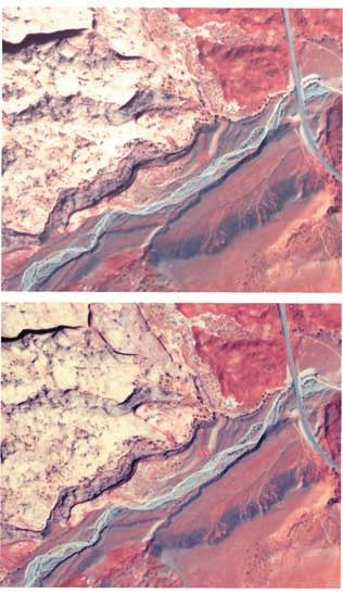
8 Figure 4. Channel profiles and slope area data. (a) Ticaboo Canyon profiles. Locations shown in Figure 3a. Channel 3 1 is offset by 1 km (x axis) for clarity. Near confluences, tributary slopes are lower than the main stem slope. (b) Trail Canyon, Trib43, Trib44, and 1 48 (Maidenwater); locations shown in Figure 3b. The tributary channels are incised more deeply to lower slopes than Trail Canyon in the vicinity of the confluences. Trail Canyon and 1 48 do not share a confluence directly but are both nearby tributaries of the larger Trachyte Creek. (c) DEM slope area data plotted for Trail Canyon, Trib43, and Maidenwater south. The diorite-poor channels have locally high slopes, but Trail Canyon has higher overall slopes at a given drainage area. Slopes were calculated over 24.4 m of vertical elevation, which corresponded to two contour intervals in the original data (USGS quadrangles; contour interval 40 feet). No other smoothing was done. the basal part of the Navajo Sandstone as well as possible undermining due to other weathering and erosional processes such as groundwater seepage, as is sometimes observed near this stratigraphic contact [e.g., Howard and Kochel, 1988; Lamb et al., 2006]. Nonetheless, incision of the Ticaboo main stem has been inhibited by its abundant diorite gravel bed load, preventing the river from exploiting a horizon of weak rock (Figure 4a). Bedrock exposed along the main stem channels of both Ticaboo Canyon and Trail Canyon indicates that the channels were not incised more deeply in the past. Figure 3. Ticaboo Canyon and Trail Canyon. (a) Landsat image (bands 5, 4, 2, partially decorrelation stretched) of Ticaboo Canyon. Location shown in Figure 1. Channel traces are offset 500 m east to make the differences in alluvial fill between valleys more visible. Diorite pediments and valley fill appear gray, in contrast to the green (Jca, Carmel Formation) and pink (Jn, Navajo Sandstone) sedimentary bedrock units. (b) Landsat image showing Trail Canyon and diorite-poor tributaries. Location indicated in Figure 1. Photograph of epigenetic gorge in Figure 6c. (c) Aerial photograph showing Trail and Maidenwater canyons. Note the difference between Jca (dark red), Jn (tan), and diorite-rich alluvium (gray) filling the Trail Canyon valley. Location shown in Figure 4b (rectangle). (d) Stereo air photographs showing the confluences of Trail Canyon, Trib43, and Trib44. Location indicated in Figure 3c. To view in stereo, rotate the page 90 clockwise, relax your eyes, focus on infinity, and let the images overlap. The asterisk is the 13 m fill terrace similarly marked in Figure 6. Note that the Trib43 channel elevations are lower than the adjacent Trail Canyon. 8of21
9 [29] Because lithologic heterogeneities and groundwater seepage may have influenced incision of the Ticaboo Canyon tributaries, we focus our analysis on Trail Canyon and surrounding channels. Figure 4c shows that DEMderived slope area data for Trail Canyon are well fit by a power law as has been widely observed for both alluvial and bedrock channels [e.g., Flint, 1974; Howard and Kerby, 1983; Howard et al., 1994; Wobus et al., 2006]. In log-log space the power law relation S A q plots as a straight line with slope q, which is defined as the channel concavity index [e.g., Whipple and Tucker, 1999]. A regression through the Trail Canyon data gives q = 0.58 (R 2 = 0.94), which is within the range of concavities common for fluvial channels (q 0.3 to 0.7) [Whipple, 2004]. Over most of their length, including the steeper headwater reaches, the smaller tributaries have more variable but lower slopes than Trail Canyon at comparable drainage areas. This is true not only for Trib43 and Maidenwater, but also for the other diorite-poor channels shown in Figures 2 and 4. [30] We have observed that Trail Canyon receives snowmelt flow in some years in addition to flash floods, consistent with flow monitoring in a nearby channel [Johnson et al., 2005]. Owing to their lower headwater elevations the tributaries only receive flash floods. Precipitation rate increases with elevation in this landscape [Gilbert, 1877; Hunt, 1953], and so Trail Canyon can be thought of as effectively having greater discharge, relative to the tributaries, than is reflected in the differences in drainage area (Figure 4c). However, the elevation ranges of the surveyed main stem and tributary reaches are similar and so the frequency and intensity of flash flood rainfall events should be equivalent between channels over this elevation range. In addition, we interpret less efficient incision on Trail Canyon relative to the tributaries, even though the increase in discharge due to snowmelt would be expected to increase efficiency. Drainage area is therefore a conservative discharge proxy for comparing these channels. We do not further exaggerate the differences between channels by attempting to correct for increased precipitation with elevation. [31] Upstream of the surveyed reach, Trail Canyon is modestly incised into colluvium and pediment deposits surrounding Mt Hillers, giving it an abundant supply of diorite sediment in addition to that stored in its valley (Figures 1 and 3b). On the basis of aerial photographs and Landsat imagery, 94 ± 3% of the Trail Canyon watershed area upstream of the Trib43 confluence has surface cover of diorite bedrock, colluvium, pediment and valley fill. In contrast, the Trib43 watershed has 21 ± 5% of its area covered by diorite, all upstream in the less incised headwaters. Trib44 has no diorite sources evident in its watershed. The supply of coarse diorite sediment likely decreases from Trail Canyon to Trib43 to Trib44. To summarize, the availability of diorite sediment supply correlates with differences in longitudinal profile smoothness and slopes. Slopes are steeper in the channels rich in coarse diorite sediment, especially when accounting for drainage area differences (Figure 4) Field Surveys [32] On the basis of the regional analysis, detailed field surveys were conducted along 7.3 km of Trail Canyon, 2.6 km of Trib43, 0.45 km of Trib44 and 2.0 km of the south fork of Maidenwater Canyon (Figure 5a). Surveyed reaches correspond to DEM-derived drainage areas of 13.6 to 21.8 km 2 along Trail Canyon, 1.2 to 3.3 km 2 along Trib43, 0.7 to 1 km 2 along Trib44 and 1.8 to 12 km 2 along Maidenwater. The bedrock exposed in the surveyed reaches of the tributaries (43, 44) and Maidenwater is Navajo Sandstone. Downstream of the Trib43 confluence all of the bedrock exposed in Trail Canyon is Navajo Sandstone, whereas upstream of the trib43 confluence the active Trail Canyon channel is close to the contact between Navajo Sandstone and Carmel Formation, with Navajo Sandstone and rarely Carmel Formation exposed in the bed Channel Profiles [33] Like the coarser-resolution DEM profiles, Figure 5b shows that (1) Trib43 and Trib44 have lower slopes than the main stem Trail Canyon and (2) Trail Canyon has less slope variability. Standard deviations (1s) of surveyed reach gradients (weighted for reach length) are 0.02, 0.05, 0.05 and 0.08 for Trail, Trib43, Trib44 and Maidenwater respectively, giving coefficients of variation (standard deviation divided by mean) of 0.4, 1.1, 2.9 and 2.0 respectively. These also serve as crude measurements of differences in bed roughness between the channels, and indicate that Trail Canyon is less rough at the reach scale than the others. Individual reaches were surveyed to capture changes in local slope, and the smoother profile of Trail Canyon is not an artifact of differences in reach lengths. Trib43, Trib44 and Maidenwater have impassable reaches with narrow slots, bedrock steps and boulder jams that restricted the total lengths of our surveys (Figure 5a). Trib44 has high slope variability due in part to a series of channel-spanning bedrock potholes. In contrast, as its name implies Trail Canyon provides the easiest access to the perennially flowing Trachyte Creek Channel Morphology [34] Differences in channel morphology and bed cover are apparent at tributary junctions. Although both Trib43 and Trail Canyon have exposed Navajo Sandstone bedrock, the gray diorite sediment in Trail Canyon contrasts sharply with the bare bedrock in Trib43 (Figure 6a). Trib44 has essentially no coarse sediment on its bed, only sand, and has incised to a lower reach slope than boulder-laden Trib43 despite its smaller drainage area (Figure 6b). [35] Trail Canyon tends to have a consistently flat bottom and rectangular cross section (Figure 7). Large boulders are occasionally present in the valley fill, and imbrication suggests that small boulders and cobbles are actively transported in the channel (Figure 7a). However, coarse sediment jams are almost never observed along Trail Canyon. Although we do not have independent quantitative measurements of bed roughness apart from standard deviations of surveyed reach gradients (section 5.2.1), field observations suggest that grain size is a large component of Trail Canyon bed roughness. Exposed bedrock tends to grade smoothly with surrounding alluvial cover rather than forming steps (Figures 6a and 7b). In contrast, Trib43 has bedrock steps and channel-spanning boulder jams (Figures 5, 6, and 7c). Sediment is sorted longitudinally, with sand and fine gravels just downstream of steps. Sediment coarsens downstream as the next bedrock step or boulder jam is approached. Maidenwater reach morphologies are similar to Trib43. Trib44 has very little coarse sediment and no boulder jams. 9of21
10 Figure 5. Field-surveyed channel profiles. (a) Complete distances surveyed along each channel. A steep impassable reach in Trib43 (dotted line, 14 km upstream, 150 m long) was not surveyed. (b) A close-up view of surveyed reaches, showing differences in slope and profile smoothness. Survey points were chosen to capture changes in local slope (described in section 4), and so the smoother profile of Trail Canyon is not an artifact of the wider sample spacing. The Trib43 bedrock step is shown in Figure 6a. Maidenwater Canyon has a 5 m waterfall where the channel crosses a small carbonate-rich bed within the Navajo Sandstone. Bedrock in the Trib44 channel bottom appears fresh and is eroded into potholes and other sculpted forms, while bedrock above the active channel is more weathered (Figure 7d). [36] Channel widths increase downstream but are highly variable and do not depend monotonically on drainage area (Figure 8). It is surprising that the mean widths of the different channels are similar since the Trail Canyon drainage area is five times larger than Trib43 and 30 times larger than Trib44. However, differences in channel morphology, sediment cover and bank material may influence the variability in widths. The Trail Canyon banks are mostly defined by coarse alluvium. The banks in Trib43 vary from sand to coarse diorite cobbles to bedrock, while in Trib44 the banks vary between sand and bedrock. [37] Abundant bed cover was observed along all of the channels (Figure 8). Averaged over the surveyed distances, Trail, Trib43 and Trib44 have 4% ± 2%, 15% ± 5% and 35% ± 10% bedrock exposed in the channel bed respectively. Uncertainties are 2 standard error (2S e ); each distribution has a sufficient number of points so that 2S e approximately gives 95% confidence intervals on the mean amount of bedrock exposed in each channel. Bedrock exposure in the channel banks is higher, with 14 ± 3%, 52 ± 6% and 64 ± 10% (2S e ) exposed in the banks of Trail, Trib43 and Trib44, respectively (data not shown). Bedrock exposure in the bed decreases with increasing channel gradient (R 2 = 0.8) (Figure 9) Fill Terraces and Floodplains [38] A terrace level about 13 m above the active channel is well preserved along Trail Canyon (Figures 3 and 6). Terraces of similar height are found along many sedimentrich channels including Ticaboo Canyon and Trachyte Creek. The fill terrace records the Trail Canyon valley slope during past aggradation, and is consistent with the presentday valley slope. In section 6, we interpret that the current channel slope is adjusted to transport its coarse sediment load, as would be the case during aggradation. Correlatable terrace remnants are not present in Trib43 or Trib44, perhaps owing to a lack of coarse sediment availability or a lack of subsequent preservation in the narrower tributary valleys. [39] Figure 6c shows a location along Trail Canyon in which the terrace is preserved to the right of a bedrock knob, and the active channel now flows through the 10 of 21
 The view looking upstream at the confluence of Trail Canyon (left) and Trib43 (right) shows differences in coarse sediment bed cover between the channels.")
11 Figure 6. Photographs comparing tributaries. (a) The view looking upstream at the confluence of Trail Canyon (left) and Trib43 (right) shows differences in coarse sediment bed cover between the channels. The lithologically controlled step in Trib43 is apparent in the field-surveyed profile (Figure 5). Stratigraphically, the step occurs close to the top of the Navajo Sandstone (Jn). Darker weathered beds of the Carmel Formation (Jca) form the hillslope above. The asterisk corresponds to a 13 m fill terrace marked in Figure 3d. (b) Confluence of Trib43 and Trib44, showing more coarse sediment bed cover in Trib43. The 1.75 m laser pole is circled for scale. (c) Epigenetic gorge downstream in Trail Canyon, location shown in Figure 3b. Note field assistant for scale. bedrock-walled slot to the left. The geometry indicates that, prior to terrace aggradation, the channel had cut down to approximately the same elevation as the present channel. When downcutting later occurred the channel reincised not only through valley fill but although through bedrock that previously defined the valley margin, leaving a bedrock knob. This kind of feature has been termed an epigenetic gorge [Hewitt, 1998]. Several epigenetic gorges occur along 11 of 21

12 Figure 7. Field photographs showing channel morphology. (a) View upstream of the Trail Canyon channel. Note the imbricated cobbles in the foreground, the flat bed and rectangular channel cross section, and the active floodplain level with a higher fill terrace behind. The section of surveying rod visible is 70 cm. (b) Bedrock exposed in the Trail Canyon bed and bank, looking upstream, 1.75 m surveying rod. (c) Trib43, looking upstream. In the background, just upstream of where Jn bedrock narrows, is a steep boulder jam of diorite and sandstone boulders and cobbles. The foreground sediment is sand, illustrating longitudinal sorting. (d) Trib44, looking upstream, showing potholes and fluvial sculpting at the start of a narrow slot. All of the visible sediment is sand. Trail Canyon [Ouimet et al., 2008]. The more recent bedrock incision indicated by these features apparently has not influenced local channel slope, width or depth. [40] Field observations suggest that bankfull flows in Trail Canyon occur on a regular basis, although we have no direct measurements of flood magnitudes or recurrence intervals. Trail Canyon has an active floodplain, particularly upstream where the valley is wide. Secondary channels with mud deposition and bent and twisted vegetation on the alluvial floodplain surface indicates recent flow above bankfull Sediment Size Distribution [41] Cumulative distributions of clasts 3 mm from Trail Canyon, Trib43 and Trib44 are statistically significantly different (Figure 10a). Alluvium ranging in size from sand to boulders can be found in both Trail Canyon and Trib43, but Trib43 has a broader distribution (less well sorted). We can reject the null hypothesis that the measured diameters come from the same total distribution with >99% confidence (two-sample Kolmogorov-Smirnov test) [Hayter, 1996]. However, the mean and median values of the distributions for Trail Canyon and Trib43 are not significantly different (T test with unequal variances [Wohl et al., 1996]; Wilcoxon rank sum test). Sediment sizes are presented in millimeters but statistical comparisons were calculated using log-transformed values. Particles <3 mm (mostly sand) were omitted from the size distributions assuming that during relevant flows the fine sediment will be suspended and contribute little to bed load flux. Trail Canyon and Trib43 had similar total fractions of sand covering the bed (30% and 27% respectively). In contrast, we estimated in the field that the surface sediment in Trib44 was 98% sand. The Trail Canyon and Trib43 size distributions were measured by random walks, but the Trib44 distribution represents the coarse sediment trapped in two 12 of 21

13 Figure 8. Surveyed bankfull width, depth, and percent bedrock exposure on the channel bed, covering the complete distances surveyed along each channel. Horizontal plot scales are different for each channel, but vertical scales are the same. Width decreases upstream of km along Trib44 because the channel enters the bedrock-walled slot shown in Figure 7d. Uncertainties are discussed in the text. potholes as well as an isolated coarser patch measured by random walk in the channel. [42] The Trail Canyon and Trib43 size distributions in Figure 10a represent amalgamations of pebble counts measured in separate channel reaches. In Trail Canyon, five reaches of approximately 50 m each were spaced over 700 m of channel distance; the field survey demonstrated that channel longitudinal slope was constant over this distance. Approximately 100 clasts were measured in each reach (Figure 10b). An analysis of variance (ANOVA, a = 0.05) 13 of 21
14 5.3. Analysis of Trail Canyon: Critical Shear Stress, Sediment Flux, and Channel Gradient [45] In this section, we calculate that thresholds for sediment motion are exceeded in Trail Canyon at flow depths well below bankfull, and we explore the degree to which Trail Canyon is graded to transport its sediment load. Boundary shear stress t b is calculated assuming steady, uniform flow: t b ¼ r w grs ð2þ Figure 9. Reach-averaged slope plotted against percent bedrock exposure in the bed for Trib44 (distance upstream from Lake Powell to km), two reaches of Trib43 ( km and km upstream), and two reaches of Trail Canyon (upstream and downstream of the Trib43 confluence; km and km upstream). Together these reaches represent all of the surveyed distance along these channels (Figures 5 and 8). demonstrates that the five distributions are statistically indistinguishable from one another, indicating negligible reach-scale longitudinal sorting along Trail Canyon. [43] In contrast, sediment size distributions vary greatly between Trib43 reaches (Figure 10b). Point counts were conducted in 10 reaches along 256 m of the channel with no distance between adjacent reaches. Reach boundaries were chosen to capture local slope changes. Only 50 clast diameters were measured in each reach. An analysis of variance (a = 0.05) allows us to reject the null hypothesis that the Trib43 reach size distributions are indistinguishable from one another, in contrast to the Trail Canyon reaches. Reach slope and D 50 are correlated in Trib43, with slope explaining nearly 2/3 of the variation in D 50 (R 2 = 0.63) (Figure 10c). Longitudinal sediment sorting has formed boulder jams, bedrock steps and lower gradient reaches in Trib43. [44] To constrain how diorite clasts contribute to the total coarse sediment load, clast lithologies were categorized as either diorite or sandstone (small numbers of resistant carbonate and chert clasts have been included in the sandstone distributions). In Trail Canyon, 79% of clasts 3 mm were diorite and 21% sandstone. In Trib43, diorite clasts comprise 52% of the coarse sediment, compared to 48% sandstone clasts. Surprisingly, diorite clasts in Trib43 are larger than in Trail Canyon (Trib43 diorite D 50,dt = 72 mm, D 90,dt = 280 mm, Trail Canyon diorite D 50,dt = 52 mm, D 90,dt = 129 mm), even though diorite clasts make up a smaller fraction of the Trib43 sediment load and less diorite is available in the Trib43 watershed. We cannot discount the possibility that Trib43 receives coarser diorite sediment, but it is unlikely considering that the progressive erosion of alluvium from pediment surfaces has been a key source of diorite clasts for both channels. We argue below that preferential transport of finer sediment from Trib43 has left a lag of coarse clasts. where S is the downstreambed gradient (assumed equal to the water surface gradient), g is gravitational acceleration, and r w is the density of water. The hydraulic radius R equals wd/(w + 2d) assuming a rectangular channel cross section. The Trail Canyon channel geometry is broadly consistent with the use of equation (2) because the channel has welldefined widths, rectangular cross sections, and little longitudinal or lateral sediment sorting (Figures 6, 7, and 10). Equivalent calculations are not presented for Trib43 because it has step-pools, highly variable slopes and strong longitudinal sediment sorting, all of which limit the application of these simple calculations [e.g., Zimmermann and Church, 2001; Yager et al., 2007]. [46] The shields stress t b * is a nondimensionalization of t b : t b t b * ¼ ðr s r w ÞgD where r s is sediment density and D is a representative grain size, typically D 50. For Trail Canyon, D 50 = 46 mm and D 90 = 120 mm (Figure 10). For hydraulically rough flow, estimates of the critical shields stress (t * cr ) to initiate motion range from 0.03 to 0.06 or higher for organized, armored beds [Zimmermann and Church, 2001]. The lack of bed armoring suggests a low value of t * cr [Reid et al., 1998] while the high channel slope suggests a high value [Lamb et al., 2008], so an average value of t * cr = is assumed. [47] Volumetric bed load transport rate is calculated using the Fernandez Luque and van Beek [1976] bed load relation: q t ¼ 5:7 r b gd 3 ð3þ 0:5 tb * 1:5 t cr * ð4þ where q t is sediment transport capacity per unit width (Q t /w) and r b is the nondimensional buoyant density, (r s /r) 1. If bed load sediment is not supply limited then sediment flux per unit width q s equals q t. The limited work on sediment transport in flash flood dominated systems suggests that sediment transport relations developed in other environments may be generally applicable. For a flash flood channel in Israel, Reid et al. [1998] found a best fit bed load relation that only varies from equation (4) a small amount in the prefactor (4.21 instead of 5.7), exponent (1.37 instead of 1.5) and t * cr (0.03). [48] Field observations indicate that bankfull flow is common in Trail Canyon, and so we calculated shear stresses using surveyed values for local reach bankfull width, depth and slope. Figure 11a shows a histogram of excess Shields stress (t * b /t * cr 1) for D 50 and D 90 calculated 14 of 21
Implications of the Saltation Abrasion Bedrock Incision Model for Steady-State River Longitudinal Profile Relief and Concavity
 Earth Surface Processes and Landforms Steady-State Earth Surf. Process. Bedrock Landforms River Longitudinal 33, 1129 1151 Profile (2008) Relief and Concavity 1129 Published online in Wiley InterScience
mountain rivers fixed channel boundaries (bedrock banks and bed) high transport capacity low storage input output
 high transport capacity low storage input output") mountain rivers fixed channel boundaries (bedrock banks and bed) high transport capacity low storage input output strong interaction between streams & hillslopes Sediment Budgets for Mountain Rivers Little
mountain rivers fixed channel boundaries (bedrock banks and bed) high transport capacity low storage input output strong interaction between streams & hillslopes Sediment Budgets for Mountain Rivers Little
Predictions of steady state and transient landscape morphology using sediment-flux-dependent river incision models
 Click Here for Full Article JOURNAL OF GEOPHYSICAL RESEARCH, VOL. 112,, doi:10.1029/2006jf000567, 2007 Predictions of steady state and transient landscape morphology using sediment-flux-dependent river
Contrasting bedrock incision rates from snowmelt and flash floods in the Henry Mountains, Utah
 Contrasting bedrock incision rates from snowmelt and flash floods in the Henry Mountains, Utah Joel P.L. Johnson 1,, Kelin X. Whipple 2, and Leonard S. Sklar 3 1 The University of Texas at Austin, Department
Sediments and bedrock erosion
 Eroding landscapes: fluvial processes Sediments and bedrock erosion Mikaël ATTAL Marsyandi valley, Himalayas, Nepal Acknowledgements: Jérôme Lavé, Peter van der Beek and other scientists from LGCA (Grenoble)
Each basin is surrounded & defined by a drainage divide (high point from which water flows away) Channel initiation
 Channel initiation") DRAINAGE BASINS A drainage basin or watershed is defined from a downstream point, working upstream, to include all of the hillslope & channel areas which drain to that point Each basin is surrounded &
DRAINAGE BASINS A drainage basin or watershed is defined from a downstream point, working upstream, to include all of the hillslope & channel areas which drain to that point Each basin is surrounded &
NATURAL RIVER. Karima Attia Nile Research Institute
 NATURAL RIVER CHARACTERISTICS Karima Attia Nile Research Institute NATURAL RIVER DEFINITION NATURAL RIVER DEFINITION Is natural stream of water that flows in channels with ih more or less defined banks.
Geomorphology Geology 450/750 Spring Fluvial Processes Project Analysis of Redwood Creek Field Data Due Wednesday, May 26
 Geomorphology Geology 450/750 Spring 2004 Fluvial Processes Project Analysis of Redwood Creek Field Data Due Wednesday, May 26 This exercise is intended to give you experience using field data you collected
Landscape Development
 Landscape Development Slopes Dominate Natural Landscapes Created by the interplay of tectonic and igneous activity and gradation Deformation and uplift Volcanic activity Agents of gradation Mass wasting
Streams. Water. Hydrologic Cycle. Geol 104: Streams
 Streams Why study streams? Running water is the most important geologic agent in erosion, transportation and deposition of sediments. Water The unique physical and chemical properties of water make it
Numerical study of degradation of fluvial hanging valleys due to climate change
 Click Here for Full Article JOURNAL OF GEOPHYSICAL RESEARCH, VOL. 114,, doi:10.1029/2007jf000965, 2009 Numerical study of degradation of fluvial hanging valleys due to climate change Joseph K. Goode 1
Riparian Assessment. Steps in the right direction... Drainage Basin/Watershed: Start by Thinking Big. Riparian Assessment vs.
 Riparian Assessment vs. Monitoring Riparian Assessment What is a healthy stream? Determine stream/riparian health Determine change or trend, especially in response to mgmt Classification = designation
Modeling the effects of weathering on bedrock floored channel geometry
 JOURNAL OF GEOPHYSICAL RESEARCH, VOL. 116,, doi:10.1029/2010jf001908, 2011 Modeling the effects of weathering on bedrock floored channel geometry Gregory S. Hancock, 1 Eric E. Small, 2 and Cameron Wobus
Formation of Fluvial Hanging Valleys: Theory and Simulation
 Formation of Fluvial Hanging Valleys: Theory and Simulation Benjamin T. Crosby 1,2 Kelin X Whipple 1 Nicole M. Gasparini 3 Cameron W. Wobus 1,4 1 Department of Earth, Atmospheric and Planetary Sciences,
Cover effect in bedrock abrasion: A new derivation and its implications for the modeling of bedrock channel morphology
 JOURNAL OF GEOPHYSICAL RESEARCH, VOL. 112,, doi:10.1029/2006jf000697, 2007 Cover effect in bedrock abrasion: A new derivation and its implications for the modeling of bedrock channel morphology Jens M.
UC Santa Cruz UC Santa Cruz Electronic Theses and Dissertations
 UC Santa Cruz UC Santa Cruz Electronic Theses and Dissertations Title A Field Test Of The Influence Of Grain Size In Determining Bedrock River Channel Slope Permalink https://escholarship.org/uc/item/0nc781r7
FLUVIAL LANDFORMS. Floodplains
 FLUVIAL LANDFORMS Floodplains fairly flat & continuous surface occupying much of a valley bottom normally underlain by unconsolidated sediments subject to periodic flooding (usually once every year or
Stream Classification
 Stream Classification Why Classify Streams? Communication Tool Describe Existing Conditions & Trends Describe Restoration Goals Research Tool Morphologic Stream Classification Systems Schumm (1977) Alluvial
ADDRESSING GEOMORPHIC AND HYDRAULIC CONTROLS IN OFF-CHANNEL HABITAT DESIGN
 ADDRESSING GEOMORPHIC AND HYDRAULIC CONTROLS IN OFF-CHANNEL HABITAT DESIGN Conor Shea - Hydrologist U.S. Fish and Wildlife Service Conservation Partnerships Program Arcata, CA Learning Objectives Examine
ES 105 Surface Processes I. Hydrologic cycle A. Distribution % in oceans 2. >3% surface water a. +99% surface water in glaciers b.
 ES 105 Surface Processes I. Hydrologic cycle A. Distribution 1. +97% in oceans 2. >3% surface water a. +99% surface water in glaciers b. >1/3% liquid, fresh water in streams and lakes~1/10,000 of water
Down-stream process transition (f (q s ) = 1)
 = 1)") Down-stream process transition (f (q s ) = 1) Detachment Limited S d >> S t Transport Limited Channel Gradient (m/m) 10-1 Stochastic Variation { Detachment Limited Equilibrium Slope S d = k sd A -θ d S
Down-stream process transition (f (q s ) = 1) Detachment Limited S d >> S t Transport Limited Channel Gradient (m/m) 10-1 Stochastic Variation { Detachment Limited Equilibrium Slope S d = k sd A -θ d S
Streams. Stream Water Flow
 CHAPTER 14 OUTLINE Streams: Transport to the Oceans Does not contain complete lecture notes. To be used to help organize lecture notes and home/test studies. Streams Streams are the major geological agents
Surface Water and Stream Development
 Surface Water and Stream Development Surface Water The moment a raindrop falls to earth it begins its return to the sea. Once water reaches Earth s surface it may evaporate back into the atmosphere, soak
Diego Burgos. Geology 394. Advisors: Dr. Prestegaard. Phillip Goodling
 Sediment Transport into an Urban Tributary Junction Diego Burgos Geology 394 Advisors: Dr. Prestegaard Phillip Goodling 1 Abstract Tributary junctions are an important component of stream morphology and
The Effects of Hydraulic Structures on Streams Prone to Bank Erosion in an Intense Flood Event: A Case Study from Eastern Hokkaido
 Symposium Proceedings of the INTERPRAENENT 2018 in the Pacific Rim The Effects of Hydraulic Structures on Streams Prone to Bank Erosion in an Intense Flood Event: A Case Study from Eastern Hokkaido Daisuke
Mountain Rivers. Gutta cavat lapidem. (Dripping water hollows out a stone) -Ovid, Epistulae Ex Ponto, Book 3, no. 10, 1. 5
 -Ovid, Epistulae Ex Ponto, Book 3, no. 10, 1. 5") Mountain Rivers Gutta cavat lapidem (Dripping water hollows out a stone) -Ovid, Epistulae Ex Ponto, Book 3, no. 10, 1. 5 Mountain Rivers Fixed channel boundaries (bedrock banks and bed) High transport
Mountain Rivers Gutta cavat lapidem (Dripping water hollows out a stone) -Ovid, Epistulae Ex Ponto, Book 3, no. 10, 1. 5 Mountain Rivers Fixed channel boundaries (bedrock banks and bed) High transport
GEOL 652. Poudre River Fieldtrip
 GEOL 652. Poudre River Fieldtrip One of the more difficult variables to measure and/or estimate when studying flow in natural channels is that of roughness. Roughness, usually approximated with Manning
Formation of fluvial hanging valleys: Theory and simulation
 Click Here for Full Article JOURNAL OF GEOPHYSICAL RESEARCH, VOL. 112,, doi:10.1029/2006jf000566, 2007 Formation of fluvial hanging valleys: Theory and simulation Benjamin T. Crosby, 1,2 Kelin X. Whipple,
Rivers. Regents Earth Science Weathering & Erosion
 Regents Earth Science Weathering & Erosion Name: Rivers Use your notes, the handout Weathering and Erosion and your review book to answer the following questions on Rivers. Be sure to read the information
Weathering, Erosion, Deposition, and Landscape Development
 Weathering, Erosion, Deposition, and Landscape Development I. Weathering - the breakdown of rocks into smaller particles, also called sediments, by natural processes. Weathering is further divided into
Laboratory Exercise #3 The Hydrologic Cycle and Running Water Processes
 Laboratory Exercise #3 The Hydrologic Cycle and Running Water Processes page - 1 Section A - The Hydrologic Cycle Figure 1 illustrates the hydrologic cycle which quantifies how water is cycled throughout
SUPPLEMENTAL MATERIAL
 SUPPLEMENTAL MATERIAL DESCRIPTIONS OF OTHER STRATIGRAPHIC SECTIONS Cherry Creek In its middle reaches, Cherry Creek meanders between three paired terraces within a narrow bedrock valley. The highest is
Running Water Earth - Chapter 16 Stan Hatfield Southwestern Illinois College
 Running Water Earth - Chapter 16 Stan Hatfield Southwestern Illinois College Hydrologic Cycle The hydrologic cycle is a summary of the circulation of Earth s water supply. Processes involved in the hydrologic
The role of sediment in controlling steady-state bedrock channel slope: Implications of the saltation abrasion incision model
 Geomorphology 82 (2006) 58 83 www.elsevier.com/locate/geomorph The role of sediment in controlling steady-state bedrock channel slope: Implications of the saltation abrasion incision model Leonard S. Sklar
PolyMet NorthMet Project
 RS 26 Draft-01 December 8, 2005 RS26 Partridge River Level 1 Rosgen Geomorphic Survey Rosgen Classification Partridge River from Headwaters to Colby Lake Prepared for PolyMet NorthMet Project December
Aquifer an underground zone or layer of sand, gravel, or porous rock that is saturated with water.
 Aggradation raising of the streambed by deposition that occurs when the energy of the water flowing through a stream reach is insufficient to transport sediment conveyed from upstream. Alluvium a general
A model for fluvial bedrock incision by impacting suspended and bed load sediment
 Click Here for Full Article JOURNAL OF GEOPHYSICAL RESEARCH, VOL. 113,, doi:10.1029/2007jf000915, 2008 A model for fluvial bedrock incision by impacting suspended and bed load sediment Michael P. Lamb,
Sediment and sedimentary rocks Sediment
 Sediment and sedimentary rocks Sediment From sediments to sedimentary rocks (transportation, deposition, preservation and lithification) Types of sedimentary rocks (clastic, chemical and organic) Sedimentary
11/12/2014. Running Water. Introduction. Water on Earth. The Hydrologic Cycle. Fluid Flow
 Introduction Mercury, Venus, Earth and Mars share a similar history, but Earth is the only terrestrial planet with abundant water! Mercury is too small and hot Venus has a runaway green house effect so
Laboratory Exercise #4 Geologic Surface Processes in Dry Lands
 Page - 1 Laboratory Exercise #4 Geologic Surface Processes in Dry Lands Section A Overview of Lands with Dry Climates The definition of a dry climate is tied to an understanding of the hydrologic cycle
Determination of uplift rates of fluvial terraces across the Siwaliks Hills, Himalayas of central Nepal
 Determination of uplift rates of fluvial terraces across the Siwaliks Hills, Himalayas of central Nepal Martina Böhme Institute of Geology, University of Mining and Technology, Freiberg, Germany Abstract.
Rivers T. Perron
 1 Rivers T. Perron 12.001 After our discussions of large-scale topography, how we represent topography in maps, and how topography interacts with geologic structures, you should be frothing at the mouth
Dams, sediment, and channel changes and why you should care
 Dams, sediment, and channel changes and why you should care Gordon E. Grant USDA Forest Service PNW Research Station Corvallis, Oregon Dam effects on river regimes FLOW (Q) SEDIMENT (Qs) TEMP CHEMISTRY
GLG598 Surface Processes and Landform Evolution K. Whipple Fall 2012 VERDE RIVER: FLOW MECHANICS, ROUGHNESS, AND SHEAR STRESS
 VERDE RIVER: FLOW MECHANICS, ROUGHNESS, AND SHEAR STRESS This lab will introduce you to some common field techniques and some general understanding of the geomorphic processes operating in a stream. The
DETAILED DESCRIPTION OF STREAM CONDITIONS AND HABITAT TYPES IN REACH 4, REACH 5 AND REACH 6.
 DETAILED DESCRIPTION OF STREAM CONDITIONS AND HABITAT TYPES IN REACH 4, REACH 5 AND REACH 6. The Eklutna River was divided into study reaches (figure 1) prior to this site visit. Prominent geologic or
Edinburgh Research Explorer
 Edinburgh Research Explorer GEOMORPHOLOGY Rivers split as mountains grow Citation for published version: Attal, M 2009, 'GEOMORPHOLOGY Rivers split as mountains grow' Nature Geoscience, vol. 2, no. 11,
Colorado River sediment transport 1. Natural sediment supply limitation and the influence of Glen Canyon Dam
 WATER RESOURCES RESEARCH, VOL. 36, NO. 2, PAGES 515 542, FEBRUARY 2000 Colorado River sediment transport 1. Natural sediment supply limitation and the influence of Glen Canyon Dam David J. Topping U.S.
Morphologically based model of bed load transport capacity in a headwater stream
 JOURNAL OF GEOPHYSICAL RESEARCH, VOL. 110,, doi:10.1029/2003jf000117, 2005 Morphologically based model of bed load transport capacity in a headwater stream Erich R. Mueller and John Pitlick Department
GEOL 1121 Earth Processes and Environments
 GEOL 1121 Earth Processes and Environments Wondwosen Seyoum Department of Geology University of Georgia e-mail: seyoum@uga.edu G/G Bldg., Rm. No. 122 Seyoum, 2015 Chapter 6 Streams and Flooding Seyoum,
Ways To Identify Background Verses Accelerated Erosion
 Ways To Identify Background Verses Accelerated Erosion Establish Background Condition From Old Ground Photos, Aerial Photos, and Maps Compare Rate Over Time At the Same Location, or for Reaches Channel
Summary. Streams and Drainage Systems
 Streams and Drainage Systems Summary Streams are part of the hydrologic cycle and the chief means by which water returns from the land to the sea. They help shape the Earth s surface and transport sediment
Erosion Surface Water. moving, transporting, and depositing sediment.
 + Erosion Surface Water moving, transporting, and depositing sediment. + Surface Water 2 Water from rainfall can hit Earth s surface and do a number of things: Slowly soak into the ground: Infiltration
Running Water: The Geology of Streams and Floods Running Water Chapter 14
 Geology 800 Today Running Water: The Geology of Streams and Floods Running Water Chapter 14 Next Class Oceans and Coasts 15 Stream Flow Streams Ribbons of water that flow down channels. Runoff Water in
Do you think sediment transport is a concern?
 STREAM RESTORATION FRAMEWORK AND SEDIMENT TRANSPORT BASICS Pete Klingeman 1 What is Your Restoration Project Like? k? Do you think sediment transport is a concern? East Fork Lewis River, WA Tidal creek,
STUDY GUIDE FOR CONTENT MASTERY. Surface Water Movement
 Surface Water SECTION 9.1 Surface Water Movement In your textbook, read about surface water and the way in which it moves sediment. Complete each statement. 1. An excessive amount of water flowing downslope
An integral approach to bedrock river profile analysis
 1 An integral approach to bedrock river profile analysis 2 3 J. Taylor Perron and Leigh Royden 4 5 6 Department of Earth, Atmospheric and Planetary Sciences, Massachusetts Institute of Technology, Cambridge
Modeling fluvial incision and transient landscape evolution: Influence of dynamic channel adjustment
 JOURNAL OF GEOPHYSICAL RESEARCH, VOL. 113,, doi:10.1029/2007jf000893, 2008 Modeling fluvial incision and transient landscape evolution: Influence of dynamic channel adjustment M. Attal, 1 G. E. Tucker,
MEANDER MIGRATION MODEL ASSESSMENT FOR THE JANUARY 2005 STORM, WHITMAN PROPERTY, SAN ANTONIO CREEK, VENTURA COUNTY, CALIFORNIA
 MEANDER MIGRATION MODEL ASSESSMENT FOR THE JANUARY 2005 STORM, WHITMAN PROPERTY, SAN ANTONIO CREEK, VENTURA COUNTY, CALIFORNIA Prepared by Eric Larsen, Ph.D. Mark Rains, Ph.D. October 2006 INTRODUCTION
APPENDIX E. GEOMORPHOLOGICAL MONTORING REPORT Prepared by Steve Vrooman, Keystone Restoration Ecology September 2013
 APPENDIX E GEOMORPHOLOGICAL MONTORING REPORT Prepared by Steve Vrooman, Keystone Restoration Ecology September 2 Introduction Keystone Restoration Ecology (KRE) conducted geomorphological monitoring in
Rapid incision of the Colorado River in Glen Canyon insights from channel profiles, local incision rates, and modeling of lithologic controls
 EARTH SURFACE PROCESSES AND LANDFORMS Earth Surf. Process. Landforms 34, 994 1010 (2009) Copyright 2009 John Wiley & Sons, Ltd. Published online 23 March 2009 in Wiley InterScience (www.interscience.wiley.com).1790
Geomorphic Importance of Winter Peak Flows and Annual Snowmelt Hydrographs in a Sierra Nevada Boulder-Bedrock River
 Geomorphic Importance of Winter Peak Flows and Annual Snowmelt Hydrographs in a Sierra Nevada Boulder-Bedrock River Scott McBain and Bill Trush McBain & Trush, Inc. Clavey River and Cherry Creek vicinity
PART 2:! FLUVIAL HYDRAULICS" HYDROEUROPE
 PART 2:! FLUVIAL HYDRAULICS" HYDROEUROPE 2009 1 HYDROEUROPE 2009 2 About shear stress!! Extremely complex concept, can not be measured directly!! Computation is based on very primitive hypotheses that
Rosgen Classification Unnamed Creek South of Dunka Road
 Rosgen Classification Unnamed Creek South of Dunka Road Prepared for Poly Met Mining Inc. September 2013 Rosgen Classification Unnamed Creek South of Dunka Road Prepared for Poly Met Mining Inc. September
Calculation of Stream Discharge Required to Move Bed Material
 Calculation of Stream Discharge Required to Move Bed Material Objective: Students will map two sections of a stream and calculate the depth, velocity, and discharge of flows required to move the stream
Dan Miller + Kelly Burnett, Kelly Christiansen, Sharon Clarke, Lee Benda. GOAL Predict Channel Characteristics in Space and Time
 Broad-Scale Models Dan Miller + Kelly Burnett, Kelly Christiansen, Sharon Clarke, Lee Benda GOAL Predict Channel Characteristics in Space and Time Assess Potential for Fish Use and Productivity Assess
1. Base your answer to the following question on the map below, which shows the generalized bedrock of a part of western New York State.
 1. Base your answer to the following question on the map below, which shows the generalized bedrock of a part of western New York State. 3. The table below describes the deposits that an observer saw while
Squaw Creek. General Information
 General Information is a tributary to the Salmon River. It enters the north side of the river about 0 miles downstream of North Fork, Idaho. The study reach is about a 30 ft length of stream about 2 miles
B-1. Attachment B-1. Evaluation of AdH Model Simplifications in Conowingo Reservoir Sediment Transport Modeling
 Attachment B-1 Evaluation of AdH Model Simplifications in Conowingo Reservoir Sediment Transport Modeling 1 October 2012 Lower Susquehanna River Watershed Assessment Evaluation of AdH Model Simplifications
PHYSICAL GEOGRAPHY. By Brett Lucas
 PHYSICAL GEOGRAPHY By Brett Lucas FLUVIAL PROCESSES Fluvial Processes The Impact of Fluvial Processes on the Landscape Streams and Stream Systems Stream Channels Structural Relationships The Shaping and
!"#$%&&'()*+#$%(,-./0*)%(!
*+#$%(,-./0*)%(!") 8:30 Sign in Hoosic River Revival Coalition!"#$%&&'()*+#$%(,-./0*)%(! 12-#30+4/#"5-(60 9:00 Welcome and Introductions 9:15 Goals for Today s Program: A Description of the Planning Process 9:30 First Session:
8:30 Sign in Hoosic River Revival Coalition!"#$%&&'()*+#$%(,-./0*)%(! 12-#30+4/#"5-(60 9:00 Welcome and Introductions 9:15 Goals for Today s Program: A Description of the Planning Process 9:30 First Session:
River Nith restoration, cbec UK Ltd, October 2013 APPENDIX A
 APPENDIX A FLUVIAL AUDIT METHOD STATEMENT Fluvial Audit Methodology INTRODUCTION The procedure used to characterize the geomorphic and sedimentary regimes of the River Till is an adaptation of the Fluvial
DATA REPOSITORY FIGURES AND TABLES
 GSA Data Repository Item 2016322 Sweeney, K.E., and Roering, J.J., 2016, Rapid fluvial incision of a late Holocene lava flow: Insights from lidar, alluvial stratigraphy, and numerical modeling: GSA Bulletin,
SECTION G SEDIMENT BUDGET
 SECTION G SEDIMENT BUDGET INTRODUCTION A sediment budget has been constructed for the for the time period 1952-2000. The purpose of the sediment budget is to determine the relative importance of different
Dynamique des rivières. res
 Dynamique des rivières res 1 Rivers are enormously diverse size: varies by many orders of magnitude geometry: highly variable substrate: bedrock or sediment sediment type: sediment size ranges from mud
(3) Sediment Movement Classes of sediment transported
 Sediment Movement Classes of sediment transported") (3) Sediment Movement Classes of sediment transported Dissolved load Suspended (and wash load ) Important for scouring algae Bedload (5-10% total load Moves along bed during floods Source of crushing for
(3) Sediment Movement Classes of sediment transported Dissolved load Suspended (and wash load ) Important for scouring algae Bedload (5-10% total load Moves along bed during floods Source of crushing for
Transport et Incision fluviale
 Transport et Incision fluviale 1 Sediment transport 2 Summerfield & Hulton, 1994 Sediment transport Rivers are by far the most important carriers of sediment on the continents, although glaciers have been
Topographic metrics and bedrock channels Outline of this lecture
 Topographic metrics and bedrock channels Outline of this lecture Topographic metrics Fluvial scaling and slope-area relationships Channel steepness sensitivity to rock uplift Advancing understanding of
Appendix E Rosgen Classification
 Appendix E Stream Type s Using the morphometric parameters described above, stream reaches are classified into 7 major stream types (Aa+ through G) based on s (1996) criteria. The relevant stream classifications
MATHEMATICAL MODELING OF FLUVIAL SEDIMENT DELIVERY, NEKA RIVER, IRAN. S.E. Kermani H. Golmaee M.Z. Ahmadi
 JOURNAL OF ENVIRONMENTAL HYDROLOGY The Electronic Journal of the International Association for Environmental Hydrology On the World Wide Web at http://www.hydroweb.com VOLUME 16 2008 MATHEMATICAL MODELING
Why Geomorphology for Fish Passage
 Channel Morphology - Stream Crossing Interactions An Overview Michael Love Michael Love & Associates mlove@h2odesigns.com (707) 476-8938 Why Geomorphology for Fish Passage 1. Understand the Scale of the
Annotated Bibliography of River Avulsions Pat Dryer Geography 364 5/14/2007
 Annotated Bibliography of River Avulsions Pat Dryer Geography 364 5/14/2007 1 Table of Contents Introduction 2 Annotations I. River avulsions and their deposits 2 II. Channel avulsion on alluvial fans
A generalized power law approximation for fluvial incision of bedrock channels
 JOURNAL OF GEOPHYSICAL RESEARCH, VOL. 116,, doi:1.129/29jf1655, 211 A generalized power law approximation for fluvial incision of bedrock channels Nicole M. Gasparini 1 and Mark T. Brandon 2 Received 2
Geo 302D: Age of Dinosaurs. LAB 2: Sedimentary rocks and processes
 Geo 302D: Age of Dinosaurs LAB 2: Sedimentary rocks and processes Last week we covered the basic types of rocks and the rock cycle. This lab concentrates on sedimentary rocks. Sedimentary rocks have special
The subject paper is being submitted for approval for publication in the annual volume entitled Geological Survey Research.
 Water Resources Division 345 Middlefield Road Menlo Park, California January 12, 1965 Memorandum To: Mr. Frank E. Clark, Chief, General Hydrology Branch Thru: Area Hydrologist PCA From: Valmore C. LaMarche
Vermont Stream Geomorphic Assessment. Appendix E. River Corridor Delineation Process. VT Agency of Natural Resources. April, E0 - April, 2004
 Vermont Stream Geomorphic Assessment Appendix E River Corridor Delineation Process Vermont Agency of Natural Resources - E0 - River Corridor Delineation Process Purpose A stream and river corridor delineation
River floodplain regime and stratigraphy. Drs. Nanette C. Kingma.
 River floodplain regime and stratigraphy. Drs. Nanette C. Kingma. Formation of floodplain. Formation of floodplains: lateral channel migration in channel deposition suspended-load fall out during higher
1 Project Summary. 2 Background
 Student: Lindsay Olinde Course: CE 394K..3 GIS in Water Resources UT Austin Professor: Dr. David Maidment Submitted: December 3, 2010 Investigation into whether differences in channel slope characteristicss
Analysis of coarse sediment connectivity in semiarid river channels
 Sediment Transfer tlirongh the Fluviai System (Proceedings of a symposium held in Moscow, August 2004). IAHS Publ. 288, 2004 269 Analysis of coarse sediment connectivity in semiarid river channels J. M.
Epigenetic gorges in fluvial landscapes
 Earth Surface Processes and Landforms Epigenetic Earth Surf. Process. gorges Landforms in fluvial landscapes (2008) 1 Published online in Wiley InterScience (www.interscience.wiley.com).1650 Epigenetic
Lecture Outlines PowerPoint. Chapter 5 Earth Science 11e Tarbuck/Lutgens
 Lecture Outlines PowerPoint Chapter 5 Earth Science 11e Tarbuck/Lutgens 2006 Pearson Prentice Hall This work is protected by United States copyright laws and is provided solely for the use of instructors
Fish Passage at Road Crossings
 Fish Passage at Road Crossings 1 Crossing Design Workshop Outline 1:00 to 2:00 Intro, Design Overview, Channel Width 2:00 to 2:15 Break 2:15 to 3:15 No-Slope, Stream Simulation Design 3:15 to 3:30 Break
Pratice Surface Processes Test
 1. The cross section below shows the movement of wind-driven sand particles that strike a partly exposed basalt cobble located at the surface of a windy desert. Which cross section best represents the
Ch 10 Deposition Practice Questions
 1. Base your answer to the following question on the data table below. Six identical cylinders, A through F, were filled with equal volumes of sorted spherical particles. The data table shows the particle
RIVERS, GROUNDWATER, AND GLACIERS
 RIVERS, GROUNDWATER, AND GLACIERS Delta A fan-shaped deposit that forms when a river flows into a quiet or large body of water, such as a lake, an ocean, or an inland sea. Alluvial Fan A sloping triangle
Amplification of bedrock canyon incision by wind
 SUPPLEMENTARY INFORMATION DOI: 10.1038/NGEO2381 Amplification of bedrock canyon incision by wind Jonathan P. Perkins, Noah J. Finnegan, Shanaka L. de Silva NATURE GEOSCIENCE www.nature.com/naturegeoscience
(3) Sediment Movement Classes of sediment transported
 Sediment Movement Classes of sediment transported") 9/17/15 (3) Sediment Movement Classes of sediment transported Dissolved load Suspended load Important for scouring algae Bedload (5-10% total load) Moves along bed during floods Source of crushing for
9/17/15 (3) Sediment Movement Classes of sediment transported Dissolved load Suspended load Important for scouring algae Bedload (5-10% total load) Moves along bed during floods Source of crushing for
SUPPLEMENTARY INFORMATION
 SUPPLEMENTARY INFORMATION Supplementary Information Rapid formation of a modern bedrock canyon by a single flood event Michael P. Lamb 1 and Mark A. Fonstad 2 1 California Institute of Technology, Geological
What do you need for a Marathon?
 What do you need for a Marathon? Water and a snack? What about just a normal day? 1 flush = 3.5 gallons 1 flush = 3.5 gallons 10 minute shower = 20 gal 1 flush = 3.5 gallons 10 minute shower = 20 gal Jeans
Landforms. Why does the land look like it does? 1. Controlled by water 2. Controlled by the rocks
 Landforms Why does the land look like it does? 1. Controlled by water 2. Controlled by the rocks Landforms Made by Running Water Stream erosion The evolution of a river system Entrenched meanders Fluvial
May 7, Roger Leventhal, P.E. Marin County Public Works Laurel Collins Watershed Sciences
 May 7, 2013 Roger Leventhal, P.E. Marin County Public Works Laurel Collins Watershed Sciences Background Funded in 2009 under EPA 2100 Grant for $30k and managed by SFEP Project Goals: Update original