Geological analysis of the Kållered quarry and surrounds Sand & Grus AB Jehander. 20 December By: Björn Sandström and Paul Evins
|
|
|
- Julian Hardy
- 5 years ago
- Views:
Transcription


1 quarry and surrounds Sand & Grus AB Jehander 20 December 2013 By: Björn Sandström and Paul Evins
2 Table of Contents 1 Executive Summary 3 2 Introduction 4 3 Purpose 5 4 Previous Work 5 5 Methodology, Field Conditions, Participants 7 6 Results Rock Types Distribution of Rock Types (Map Description) Important Structures Joints 15 7 Recommendations 16 8 References 17
3 1 Executive Summary This report contains most of the relevant observations made during fieldwork carried out during the period 12/11/ /11/2013 in the Kållered in accordance with the scope of work described in the WSP proposal, dated 13 September A new map and VR model was created over the Kållered. Along with structural data collected during this study, the new map shows that the area contains 20 to 50 to 100 m thick layers of mafic rock (gabbro and amphibolite) within a felsic gneissic succession. The target rock type in the quarry was previously called a diorite, but is likely more mafic and should be classified as a gabbro. Furthermore, a new unit of grey intermediate gneiss has been identified in the western part of the quarry. Major ductile and brittle structures have a major bearing on the distribution of these sheets and their likelihood of occurrence in the areas of possible quarry expansion. These structures include: Ductile folds which may repeat target layers (gabbro) or result in a limited depth for target layers. A major N-S trending fault which separates the gabbro layer in the west from amphibolite layers in the east. NW trending faults that truncate amphibolite layers and result in changes in amphibolite layer thickness. The following future work is recommended due to the complex structure and geometry of the gneisses in the quarry: Creation of a 3D geological model to better visualize and understand the distribution of target rock types, and estimate resources Core drilling to test the interpretations presented in this study at depth and predict rock quality in expansion areas Slope stability analysis along the eastern wall of the quarry


. Fig. 1.")

4 2 Introduction WSP was retained by Sand & Grus AB Jehander for geological mapping of the Kållered in Mölndal just south of Göteborg, Sweden (Figs. 1 and 2). Fig. 1. Location of the Kållered quarry Fig. 2. View towards SE of the central part of the Kållered quarry.
5 3 Purpose The purpose of this mapping exercise is threefold: To better understand the distribution of rock types within the quarry and within the confines of Jehander s Kållered tenement To target diamond drill holes for exploration under and east of the quarry To provide a foundation for a 3D geological model of the which can be used for o Extraction targeting o Resource estimation In addition, joint data collected in this study may be used as a preliminary dataset for first order slope stability analysis. The agreed upon scope of work included: 58 hours of field mapping A written report to include: o an outline of the mapping procedures utilized, o description of the rock types based on visual observations, o a summary of important findings from the mapping area including interpretations and field photographs. o recommendations for Phase 2 exploration and expansion investigations The following additional activities were performed outside of the original scope of this investigation: o Construction of a virtual reality (VR) model (Appendix 1) from 3D models provided by Johan Lindqvist of Rotoview. 4 Previous Work The geology of the area was previously mapped and presented in the following reports: Hersvik D 1999 Berggrundsgeologisk kartering av bergtäktsområdet i Kållered.16 pp. Ronge B Berggrundsgeologisk undersökning av området öster om nuvarande bergtäkt I Kållered, Migmatit Geologisk Konsultbyrå AB. 10 pp. Both studies included ocular geological mapping of surfaces inside and outside the quarry. The map of the area east of the quarry (Ronge 1998) incorporates data from two c. 200 m long trenches and 27 RC drill holes each roughly 30 m long. (Fig. 3).
6

7 Fig. 3. Top - Previous geological map of the Kållered (Hersvik 1999). Centre example rock chip logs from area east of the quarry (Ronge 1998). Bottom map of area east of the quarry (Ronge 1998). 5 Methodology, Field Conditions, Participants The previous maps presented above were georeferenced into a VR workspace which contained the 3D orthophoto model provided by Johan Lindqvist of Rotoview. This VR workspace is a standalone application that allows Sand & Grus AB Jehander to view Rotoview s 3D model on a normal PC without extra software. The maps are hand drawn copies and very few reference points could be used to place them into correct geographic space. Therefore, there may be local errors between like points on the maps and orthophoto. The site was first visited by project manager, Paul Evins and geologist Björn Sandström on 12/11/13 to establish mapping protocols and understand the large scale geological structures in the area. The bulk of field mapping was carried out by Björn Sandström during the period 21/11/ /11/2013. Observations were made using standard field equipment and techniques outlined in Coe (2010). Field mapping was based on the VR-model, field observations were hand drawn on printouts from the VR model, then digitized into the VR model (Fig. 4), and then exported to CAD (Fig. 5). Observation locations in the undeveloped eastern area outside the quarry were measured with DGPS with 5 cm accuracy. All field structural measurements were taken with a Silva compass with levelling bubble and clinometer. All field structural measurements are reported as strike-dip according to the right hand rule and are not adjusted for magnetic declination. Data from the previous maps from the quarry (Ronge 1998 and Hersvik 1999) were also incorporated into the map, especially where outcrops have been blasted away. The following new CAD layers were compiled by Björn Sandström and Maria Trapp and appear on the geological map as digital Appendix 2. Geology Faults Foliation Rock observations measured by DGPS


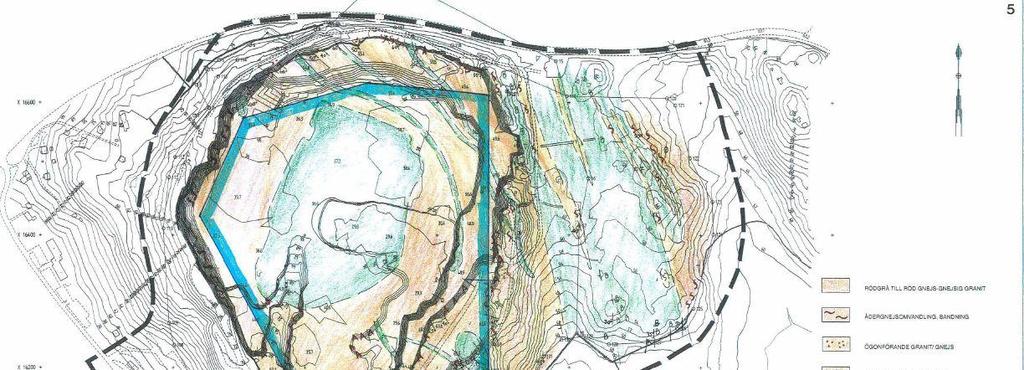
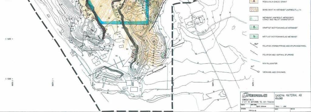
8 Fig. 4. Screenshot from the VR model used during compilation of the geological map. The black and white spheres in the foreground represent DGPS measurements of rock occurrences (black: amphibolite, white: redgrey gneiss). Yellow lines are interpreted rock contacts and red lines: fauts. View towards NW. Fig. 5. New geological map of the Kållered. The full map is presented in Appendix 1 and electronically in Appendix 2.


9 6 Results 6.1 Rock Types The Kållered area is dominated by banded gneiss with igneous protoliths. The main gneiss is a banded red to gray granitic gneiss. Individual gneissic layers range from 1 cm to 10 m depending upon the original size of the protoliths and the amount of strain. In other words, granite veins in shear zones become 1-10 cm bands while thicker granite veins or areas outside of shear zones show metre-scale banding. The banding is in part caused by and in part deflected into the regional Göta Älv shear zone that runs N-S along highway E6 and dips steeply to the west. A thick sheet of lineated fine- to medium-grained gabbro occupies the central-western part of the currently excavated quarry. This has previously been referred to as a diorite intrusion (Ronge 1988 and Hersvik 1999), but its composition is more mafic and it likely represents a mafic sill. For this study, some rock units were simplified (red and grey gneisses) and others expanded (gabbro and amphibolite). The main rock types mapped in this study are described below Grey intermediate gneiss Grey, fine- to medium-grained gneiss dominates the western part of the quarry (Fig. 7). It is banded on a cmscale and typically folded. Locally the gneiss is migmatized. The protoliths of this gneiss may be a greywacke. This unit may be the same grey gneiss unit encountered at depth in the drillholes in the eastern expansion area (Ronge 1998). This gneiss and the red-grey gneiss are tectonically interleaved at their contact. In the contact zone between the red-grey and grey gneiss, the two rock types are folded together. Fig. 7. Grey intermediate gneiss, here highly folded and with bands of red-grey gneiss. The base of the left photo is ca three meters Red-grey granitic gneiss A medium grained, red-grey granitic gneiss dominates the central parts of the investigated area (Fig. 8). The gneiss is tectonically banded and locally highly folded. In the central and eastern part of the quarry, the bands are 9 (18)


10 dm-m scaled. In the western part of the quarry and in faults, it is cm-scale banded. There are four rocktypes that make up the bands in this gneiss. The oldest is the grey intermediate gneiss described above. Locally there are layers of augen gneiss which represent originally sheets of porphyritic granite with up to cm-scale K-feldspar phenocrysts. Together these were intruded by various generations of pink granite and black mafic dykes which have been transposed into the layering. Along some of the fracture zones, particularly the water conductive zones, the gneiss is altered and rust-colored due to precipitation of Fe-oxyhydroxides. Fig. 8. Red-grey granitic gneiss. Left - meter-scale banded. The base of the left photo is ca three meters. Right cm scale banded and tightly folded augen gneiss layer Gabbro The gabbro that occurs in the central-western part of the quarry is fine- to medium-grained and dark grey. It is equigranular (Fig. 9) to weakly lineated. In the contact zone close to the red-grey and grey gneisses, backveining and some mixing between the different rock types can be seen. The lower contact of the gabbro has been uncovered along the western wall of the lowest excavation level in the quarry. The gabbro is relatively fresh with little later alteration. Normal retrograde metamorphism occurs locally amphiboles retrograded to biotite and biotite to chlorite. Minor occurrences of sulfide are associated with quartz veins in the gabbro near its contacts. 10 (18)

.")

 suggest it is not the same rock unit.")
11 Fig. 9. Gabbro occurrence in the central part of the quarry Amphibolite Amphibolite occurs abundantly in the eastern part quarry. The amphibolite is biotite-rich and shows a distinct foliation following the general foliation pattern of the gneisses in the area (Fig. 10). Locally, minor sulfide mineralization occurs within the amphibolite. It is unclear if the amphibolite is an altered, weathered, more deformed version of the gabbro described above. However, its response to deformation (foliation in the amphibolite vs. lineation in the gabbro) suggest it is not the same rock unit. A couple of geochemical analyses from both rock types could test this hypothesis. Fig. 10. Biotite rick amphibolite with distinct foliation (left) and together with sulfides (right). 11 (18)

12 6.2 Distribution of Rock Types (Map Description) The locations of rock boundaries in plan view on the previous maps are generally correct (Fig. 3). However, the shape of the gabbro body has been revised, mainly due to new information available due to further excavation in the quarry. In particular, the bottom of the gabbro layer was observed along the western wall of the lowest quarry level. Additionally, some of rock boundaries in the eastern part of the area have been adjusted due to new observations. Our mapping has revealed that some of the important rock boundaries are controlled by ductile (folds and shear zones) and brittle (faults) structures. A N-S fault zone runs through the central part of the quarry and divides the geology into eastern and western parts. The rocks in the western part of the quarry are folded by multiple generations making the shapes and contacts of rock units complex (Fig. 11). This makes the rock contacts very difficult to visualize in a 2D-map due to their complexity and moderate dip. The bottom of the gabbro unit is seen at the bottom of the quarry and is interpreted to be a c. 60 m thick sheet within the gneissic layering that dips shallowly to moderately to the west. There is a possibility that it is bowl shaped or repeated by folding which may account for its recurrence further to the west. The rocks in the eastern part of the quarry consist of a c m thick, moderately westward dipping amphibolite with 10 to 20 m thick sheets of redgrey intermediate gneiss. Fig. 11. Isoclinal fold (white line) and complex rock boundaries (red line) between gabbro, red-grey gneiss and grey gneiss. 12 (18)
.")
13 6.3 Important Structures Gneissic layering and folding The gneissic layering in the quarry generally follows a pattern of regional kilometer-scale folding. The quarry is situated on the western limb of an NNW striking anticline with a wavelength of 4-5 km (Fig. 17). Gneissic layering (foliation) in the quarry strikes NNW-SSE and dips moderately (35 to 70 ) westward (Appendix 1 and Fig. 8 and Fig. 16). The foliation is undulating and openly folded. In the central parts of the quarry, the foliation is folded into the N-S fault zone. In other areas the foliation changes abruptly across NW trending faults indicating some degree of block rotation (Appendix 1). Fig. 15. Folded gabbro and red-grey gneiss in the central part of the quarry, the plunge of the fold axis is 280/40. Meter-scale to 10 meter-scale folds were observed in the eastern contact zone between the gabbro and the redgray gneiss (Figs. 11 and 15). Two moderately west plunging (300/70 and 280/40 ) fold axis were identified and measured and are presented on the map in Appendix 1. The plunge of this folding generally matches the plunge of macroscopic scale warping (280/40 ) of foliation which is best seen where the NNW striking foliation arcs counterclockwise into near parallelism with the northern quarry wall (Figs. 5 and 16). The folding on this scale is complex and the 3D-extent of the rock types controlled by this folding cannot be fully understood without construction of a 3D model. 13 (18)

14 Fig. 16. Lower hemisphere stereographic projection of poles to foliation (dots) in the Kållered quarry and surrounds. Open stars = measured mesoscopic fold axes. Filled star = calculated mesoscopic fold axis N-S to NNW trending structures (Göta Älv zone) The western part of the quarry is situated within the Göta Älv shear zone, a regional NNW trending fault zone (Fig. 17). The zone has both a ductile and brittle history. The main gneissic layering is oriented parallel to this zone reflecting ductile transposition of layering parallel to the zone. The most prominent brittle structure in the quarry is a fault zone seen in the northern wall (Fig. 18). This zone can be traced towards the south across the quarry and to the southern wall where it appears as several more discrete faults spread over a larger area (see map in Fig. 5 and Appendix 1). Movement along this N-S trending fault is responsible for juxtaposing the different rock types found in the western and the eastern part of the quarry (Fig. 19). Fig. 17. Tectonic map of the area around the Kållered quarry (marked with circle). The pink field the represents the Göta Älv shear zone. Red lines represent fracture zones (map from SGU 1987). The base of the map is c. 4,5 km. 14 (18)


15 Fig. 18. N-S trending fault zone in the northern wall of the quarry. Fig. 19. Schematic WNW-ONO section across the N-S fault zone. For location of the section, see inset figure. Observe that all rock occurrences not are included in the section Late NW-trending faults In the eastern part of the investigated area, abrupt changes in the thickness of red-grey gneiss and amphibolite units imply the presence of NW-trending faults (Fig. 5). Some of these structures were observed on quarry walls, but the ones responsible for the thickness changes have not been observed in the field and need to be confirmed by drilling or trenching. 6.4 Joints The main foliation planes (Fig. 16) form moderately westward dipping sheets which are a major problem for bench and slope stability along the eastern side of the quarry (Fig. 20 left). Apart from the main foliation planes, there are 3 joint sets present in the quarry: N-S, NW, and E-W trending (Figs. 20 centre and right). All are nearly 15 (18)


16 vertical. The N-S joints are related to the N-S trending faults described in The NW trending joints are related to the NW-trending faults described in Fig. 20. Left - View towards the SE of unfavorably oriented foliation planes on the eastern wall causing unstable slopes. Centre - Lower hemisphere stereographic projection of poles to joints (dots) in the Kållered quarry and surrounds. Foliation joint planes not included. Right rose histogram of the strike of joints in plan view. 7 Recommendations The distribution of the gabbro body in the centre of the quarry and amphibolite layers to the east at the surface have been documented in this report. Furthermore, their thickness and extent at depth have been interpreted based on structural measurements. Remaining uncertainties regarding the interpretation of the geology of the include: 1. The shape and spatial extent of the gabbro body at depth in the western-central part of the quarry 2. The distribution of amphibolite and red-grey gneiss at depth in the eastern part of the quarry and the presence of faults within this area. We recommend core drilling to obtain structural and rock type data from depth and test the above interpretations. In particular, they drill cores may be used to constrain the thickness of the gabbro and amphibolite. Two boreholes (100 and 250 m long) with a low angle (c. 45 ) towards the east should be drilled through the amphibolite in the eastern part of the quarry. One of the holes should be orientated so that it penetrates the inferred fault zone in the area. Furthermore, two boreholes (100 m and 200 m long) should be drilled in the central-western part of the quarry with the aim of determining the extent and shape of the gabbro body (Fig. 21). The drillcore should be mapped by a geologist with experience in the quarry. The geological map or model of the area should then be updated with the data obtained from the boreholes. Due to the complexity of the rock unit boundaries, the folding and the fault zones, it is recommended that a geological 3D model of the Kållered quarry is constructed. This would increase the understanding of the spatial distribution of the different rock types at depth. In particular, volumes can be created for approximate resource estimation. The model would also enable better and more accurate visualization of the distribution of different rock types and structures for decision-making and planning of future production in the quarry. 16 (18)
 of excavation of an E-W corridor and then blasting along E-W trending face in")
 2010 Geological field techniques. Wiley-Blackwell. 336 p.")

17 A slope stability analysis of the eastern wall of the quarry is suggested if the quarry is to be expanded eastward. The earlier suggestion (Ronge 1998) of excavation of an E-W corridor and then blasting along E-W trending face in that area still applies. Fig. 18. Suggested location and direction of core drilling (red arrows). 8 References Coe A.L. (ed.) 2010 Geological field techniques. Wiley-Blackwell. 336 p. Hersvik D 1999 Berggrundsgeologisk kartering av bergtäktsområdet i Kållered.16 pp. Ronge B Berggrundsgeologisk undersökning av området öster om nuvarande bergtäkt I Kållered, Migmatit Geologisk Konsultbyrå AB. 10 pp. SGU 1978, Tektoniska kartan. Kungsbacka NO. SGU Ser. Af nr (18)
18 Appendix 1 (electronic) Geological map (pdf) Appendix 2 (electronic) Geological map (dwg) Appendix 3 (electronic) VR model Appendix 4 Field photographs 18 (18)
Appendix 11. Geology. of the. I60 area
 Appendix 11 Geology of the I60 area 1. Locality The locality of the I60 area is as follows; Northwestern corner; UTM_EW 530513, UTM_NS 7345741 Southwestern corner; UTM_EW 530418, UTM_NS 7301454 Northeastern
APPENDIX 2 Table 2. Sample descriptions
 Table 2. descriptions 225 Felsic gneiss, fine-grained and very light-gray. From the upper part of the lower of the two layers, which connect. 226 Amphibolite, even-grained, fine-grained, medium-gray, little
Answers: Internal Processes and Structures (Isostasy)
") Answers: Internal Processes and Structures (Isostasy) 1. Analyse the adjustment of the crust to changes in loads associated with volcanism, mountain building, erosion, and glaciation by using the concept
Answers: Internal Processes and Structures (Isostasy) 1. Analyse the adjustment of the crust to changes in loads associated with volcanism, mountain building, erosion, and glaciation by using the concept
Evaluation of Structural Geology of Jabal Omar
 International Journal of Engineering Research and Development e-issn: 2278-067X, p-issn: 2278-800X, www.ijerd.com Volume 11, Issue 01 (January 2015), PP.67-72 Dafalla Siddig Dafalla * and Ibrahim Abdel
LAB 1: ORIENTATION OF LINES AND PLANES
 LAB 1: ORIENTATION OF LINES AND PLANES Read the introductory section, chapter 1, pages 1-3, of the manual by Rowland et al (2007) and make sure you understand the concepts of bearing, strike, dip, trend,
P Forsmark site investigation. Detailed fracture mapping of the outcrops Klubbudden, AFM and Drill Site 4, AFM001097
 P-03-115 Forsmark site investigation Detailed fracture mapping of the outcrops Klubbudden, AFM001098 and Drill Site 4, AFM001097 Jan Hermanson, Lars Hansen, Jon Vestgård, Peter Leiner Golder Associates
2013 GEOLOGICAL ASSESSMENT REPORT SHERIDAN HILL PROPERTY
 2013 GEOLOGICAL ASSESSMENT REPORT ON THE SHERIDAN HILL PROPERTY NEW WESTMINSTER MINING DIVISION BRITISH COLUMBIA NTS 092G07 49 16 31 NORTH LATITUDE, 122 39 48 WEST LONGITUDE PREPARED FOR Sheridan Hill
Satulinmäki Au Prospect Structural Mapping
 M19/2024/2003/1/10 Juhani Ojala Satulinmäki Au Prospect Structural Mapping V. Juhani Ojala Geological Survey of Finland 1 Table of Contents Introduction...2 Local geology...2 Structures...2 Discussion...2
Hand specimen descriptions of metamorphic rocks
 Hand specimen descriptions of metamorphic rocks Hand specimen descriptions for metamorphic rocks are like those for igneous rocks. The objective is to tell someone looking at it everything they need to
COPPERSTONE RESOURCES AB INTERCEPTS ZONE OF CHALCOPYRITE-ARSENOPYRITE- BORNITE MINERALIZATION AT SVARTLIDEN IN FIRST DEEP DRILLHOLE FROM 720m-810m
 COPPERSTONE RESOURCES AB INTERCEPTS ZONE OF CHALCOPYRITE-ARSENOPYRITE- BORNITE MINERALIZATION AT SVARTLIDEN IN FIRST DEEP DRILLHOLE FROM 720m-810m In mid-january 2017 Copperstone Resource published a geological
MEMO. TO: Dennis Lapoint CC: FROM: Eriaan Wirosono DATE: April, 20 th 2014 SUBJECT: Exploration activity report March-April 2014_EW
 TO: Dennis Lapoint CC: FROM: Eriaan Wirosono DATE: April, 20 th 2014 SUBJECT: Exploration activity report March-April 2014_EW MEMO 1. Highlights and Productivity Overview pan sampling on target Areas 1
GCE AS/A level 1211/01 GEOLOGY GL1 Foundation Unit
 Surname Centre Number Candidate Number Other Names 2 GCE AS/A level 1211/01 GEOLOGY GL1 Foundation Unit S15-1211-01 A.M. MONDAY, 11 May 2015 1 hour For s use Question Maximum Mark 1. 15 2. 14 Mark Awarded
Rock slope rock wedge stability
 Engineering manual No. 28 Updated: 02/2018 Rock slope rock wedge stability Program: Rock stability File: Demo_manual_28.gsk The aim of the chapter of this engineering manual is to explain a rock slope
Mishi Lake Gold Property Mishibishu Lake Area, Wawa
 Mishi Lake Gold Property Mishibishu Lake Area, Wawa Location, Accessibility, Infrastructure and Local Resources The property is located 40 km west of Wawa, Ontario, in the Mishibishu Lake Area, Sault Ste.
FIRST YEAR ASSESSMENT REPORT PROSPECTING LICENCE 16512M MARYSTOWN AREA, BURIN PENINSULA NTS 1M/3
 FIRST YEAR ASSESSMENT REPORT OF PROSPECTING ON LICENCE 16512M MARYSTOWN AREA, BURIN PENINSULA NTS 1M/3 BY NATHANIEL NOEL MSc. FOR E. MICHELE NOEL MINERAL LICENCES: 16512 M WORK CONDUCTED: MID-SEPTEMBER
Crustal Deformation Earth - Chapter Pearson Education, Inc.
 Crustal Deformation Earth - Chapter 10 Structural Geology Structural geologists study the architecture and processes responsible for deformation of Earth s crust. A working knowledge of rock structures
Application of Core Logging Data to generate a 3D Geotechnical Block Model
 Application of Core Logging Data to generate a 3D Geotechnical Block Model Engineering Geology and Innovation: Research Infrastructure - Sustainable Development (I.A.E.G) Eleftheria Vagkli, M.Sc. Senior
Drill locations for the 2015 program are highlighted in the geology map below.
 2015 Exploration Program The exploration program plan at KSM for 2015 was designed to improve the understanding of block cave targets and support engineering/environmental aspects of development scenarios.
Appendix A2: Detailed description of all results
 Appendix A2: Detailed description of all results This Appendix presents detailed descriptions of all results in this study. It is presented separately in order to streamline the main paper, and to provide
Sotkamo Silver Mo i Rana and Tampere areas. Erkki Kuronen Chief Geologist, M.Sc., MAusIMM Sotkamo Silver Oy
 Mo i Rana and Tampere areas Erkki Kuronen Chief Geologist, M.Sc., MAusIMM Oy Mo i Rana and Tampere areas Erkki Kuronen Chief Geologist, M.Sc., MAusIMM Oy 2.9.2018 Silver 2 Deposits and Projects develops
Big Island Field Trip
 Big Island Field Trip Space Still Available Group Airline Tickets May be available if enough people sign on If interested send email to Greg Ravizza Planning Meeting Next Week Will
A.M. TUESDAY, 12 May hours
 Candidate Name Centre Number 2 Candidate Number GCE AS/A level 1212/01 New AS GEOLOGY - GL2a Investigative Geology A.M. TUESDAY, 12 May 2009 1 1 2 hours For Examiner s Use Only ADDITIONAL MATERIALS In
Name Class Date STUDY GUIDE FOR CONTENT MASTERY
 Igneous Rocks What are igneous rocks? In your textbook, read about the nature of igneous rocks. Use each of the terms below just once to complete the following statements. extrusive igneous rock intrusive
Magma transport in sheet intrusions of the Alnö carbonatite complex, central Sweden
 Supplementary Information Magma transport in sheet intrusions of the Alnö carbonatite complex, central Sweden Authors: *Magnus Andersson 1, Bjarne S.G. Almqvist 1, Steffi Burchardt 1, Valentin R. Troll
Quaternary clays alluvial sands of the Shepparton Formation overlie the basement rocks.
 NAGAMBIE GOLDFIELD Regional Geological Setting The Nagambie Project is located within the Melbourne Structural Zone of Victoria. The lithologies range in age from the Upper Silurian Broadford Formation
Stress and Strain. Stress is a force per unit area. Strain is a change in size or shape in response to stress
 Geologic Structures Geologic structures are dynamically-produced patterns or arrangements of rock or sediment that result from, and give information about, forces within the Earth Produced as rocks change
Instituto De Ingenieros De Minas Del Peru
 The Continuity Challenge Dr. Wayne Barnett The Interpretation! Great geological continuity? Huge potential? The Reality Not what it might seem... Not what it might seem... Presentation Objective Highlight
What Causes Rock to Deform?
 Crustal Deformation Earth, Chapter 10 Chapter 10 Crustal Deformation What Causes Rock to Deform? Deformation is a general term that refers to all changes in the shape or position of a rock body in response
12. MYRMEKITE IN THE SANTA ROSA MYLONITE ZONE, PALM SPRINGS, CALIFORNIA
 1 ISSN 1526-5757 12. MYRMEKITE IN THE SANTA ROSA MYLONITE ZONE, PALM SPRINGS, CALIFORNIA Lorence G. Collins email: lorencec@sysmatrix.net February 15, 1997 Introduction Myrmekite, containing tiny quartz
Master s thesis Linda Lundgren Supervisor: Charlotte Möller, Jenny Andersson, Mattias Göransson & Jan Erik Lindqvist
 Master s thesis Linda Lundgren Supervisor: Charlotte Möller, Jenny Andersson, Mattias Göransson & Jan Erik Lindqvist Department of Geology 2012 1 Outline Introduction: aim, geological setting, domain descriptions
3. GEOLOGY. 3.1 Introduction. 3.2 Results and Discussion Regional Geology Surficial Geology Mine Study Area
 3. GEOLOGY 3.1 Introduction This chapter discusses the baseline study of the geology and mineralization characteristics of the mine study area. The study consolidates existing geological data and exploration
CHAPTER 3.3: METAMORPHIC ROCKS
 CHAPTER 3.3: METAMORPHIC ROCKS Introduction Metamorphism - the process of changes in texture and mineralogy of pre-existing rock due to changes in temperature and/or pressure. Metamorphic means change
Summary of Rover Metals Geologic Mapping Program at the Up Town Gold Project, Northwest Territories
 October 13, 2017 Summary of Rover Metals Geologic Mapping Program at the Up Town Gold Project, Northwest Territories Vancouver, British Columbia, Canada - Rover Metals Corp., Rover, is pleased to provide
To get you thinking What natural process is responsible for the appearance of these rocks? Rocks and the Rock Cycle
 To get you thinking What natural process is responsible for the appearance of these rocks? Rocks and the Rock Cycle Bell Ringer Name the 3 types of rock. Is one type of rock able to change into a different
An Overview of Graphite Projects from Asia to Africa. Dr Mike Cunningham SRK Consulting (Australasia) Pty. Ltd.
 Pty. Ltd.") An Overview of Graphite Projects from Asia to Africa Dr Mike Cunningham SRK Consulting (Australasia) Pty. Ltd. Acknowledgements PT. Granfindo Nusantara RS Mines Pty Ltd Geological Survey and Mining Bureau
An Overview of Graphite Projects from Asia to Africa Dr Mike Cunningham SRK Consulting (Australasia) Pty. Ltd. Acknowledgements PT. Granfindo Nusantara RS Mines Pty Ltd Geological Survey and Mining Bureau
GS-17. Summary. Previous work. Regional setting. Introduction. Geology
 GS-17 Geology, structure and mineralization of the Ore Fault property, Bird River greenstone belt, southeastern Manitoba (parts of NTS 52L5NE and 52L6NW) by L.A. Murphy 1 and P. Theyer Murphy, L.A. and
GLY 155 Introduction to Physical Geology, W. Altermann. Grotzinger Jordan. Understanding Earth. Sixth Edition
 Grotzinger Jordan Understanding Earth Sixth Edition Chapter 4: IGNEOUS ROCKS Solids from Melts 2011 by W. H. Freeman and Company Chapter 4: Igneous Rocks: Solids from Melts 1 About Igneous Rocks Igneous
POTENTIAL OF THE DONGWE COPPER GOLD PROJECT
 POTENTIAL OF THE DONGWE COPPER GOLD PROJECT By Nathan Sabao, P.Geo. September 2015 1 TABLE OF CONTENTS Page 1.0 EXECUTIVE SUMMARY 1 2.0 LOCATION 2 3.0 ACCESS 2 4.0 GEOLOGY 3 5.0 PREVIOUS DRILLING 5 6.0
Geoelectrical and IP Imaging Used for Pre-investigation at a Tunnel Project. Danielsen, Berit Ensted; Arver, Henrik; Karlsson, T; Dahlin, Torleif
 Geoelectrical and IP Imaging Used for Pre-investigation at a Tunnel Project Danielsen, Berit Ensted; Arver, Henrik; Karlsson, T; Dahlin, Torleif 2008 Link to publication Citation for published version
Name. GEOL.5220 Structural Geology Faults, Folds, Outcrop Patterns and Geologic Maps. I. Properties of Earth Materials
 I. Properties of Earth Materials GEOL.5220 Structural Geology Faults, Folds, Outcrop Patterns and Geologic Maps Name When rocks are subjected to differential stress the resulting build-up in strain can
Part 2: Metamorphic features. Foliation, cleavage, lineation. Chapter 15
 Part 2: Metamorphic features Chapter 15 Foliation, cleavage, lineation The terms foliation and cleavage in metamorphic rocks have formal definitions, but their colloquial use in the field is commonly haphazard
DÉCOUVERTE Positioned for Discovery in James Bay, Quebec. Investor Presentation, January 2018 by Danae Voormeij, MSc, PGeo
 DÉCOUVERTE Positioned for Discovery in James Bay, Quebec Investor Presentation, January 2018 by Danae Voormeij, MSc, PGeo Location Maps and Infrastructure Location: Durango Resources 100% owned Découverte
Excursion guide NW Skåne, NGEA 01, 2018 PART 3. ASSIGNMENTS
 Excursion guide NW Skåne, NGEA 01, 2018 PART 3. ASSIGNMENTS by Associate Prof. Jonas Åkerman 1 Cover photo; The NW exposed coastline at Josefinelust with coarse beach boulders (Sw. malar ), gneiss is the
Crags, Cracks, and Crumples: Crustal Deformation and Mountain Building
 Crags, Cracks, and Crumples: Crustal Deformation and Mountain Building Updated by: Rick Oches, Professor of Geology & Environmental Sciences Bentley University Waltham, Massachusetts Based on slides prepared
Geologic Structures. Changes in the shape and/or orientation of rocks in response to applied stress
 Geologic Structures Changes in the shape and/or orientation of rocks in response to applied stress Figure 15.19 Can be as big as a breadbox Or much bigger than a breadbox Three basic types Fractures >>>
GEOL Lab 11 (Metamorphic Rocks in Hand Sample and Thin Section)
") GEOL 333 - Lab 11 (Metamorphic Rocks in Hand Sample and Thin Section) Introduction - Metamorphic rock forms from any pre-existing rock that undergoes changes due to intense heat and pressure without melting.
GEOL 333 - Lab 11 (Metamorphic Rocks in Hand Sample and Thin Section) Introduction - Metamorphic rock forms from any pre-existing rock that undergoes changes due to intense heat and pressure without melting.
Golden Cross Resources
 Golden Cross Resources Labrador Uranium Joint Venture with Altius Resources Update - November 2007 Labrador Uranium - Canada LABRADOR URANIUM PROPERTIES Golden Cross Resources signed an agreement with
Hand specimen descriptions of igneous rocks
 Hand specimen descriptions of igneous rocks Basically, hand specimen descriptions should tell someone looking at a rock everything they need to know to recognize it in the field. Descriptions should be
Igneous and Metamorphic Rock Forming Minerals. Department of Geology Mr. Victor Tibane SGM 210_2013
 Igneous and Metamorphic Rock Forming Minerals Department of Geology Mr. Victor Tibane 1 SGM 210_2013 Grotzinger Jordan Understanding Earth Sixth Edition Chapter 4: IGNEOUS ROCKS Solids from Melts 2011
B) color B) Sediment must be compacted and cemented before it can change to sedimentary rock. D) igneous, metamorphic, and sedimentary rocks
 color B) Sediment must be compacted and cemented before it can change to sedimentary rock. D) igneous, metamorphic, and sedimentary rocks") 1. Which characteristic of nonsedimentary rocks would provide the least evidence about the environment in which the rocks were formed? A) structure B) color C) crystal size D) mineral composition 2. Which
1. Which characteristic of nonsedimentary rocks would provide the least evidence about the environment in which the rocks were formed? A) structure B) color C) crystal size D) mineral composition 2. Which
Staple this part to part one of lab 6 and turn in. Lab 6, part two: Structural geology (analysis)
") Geology 101 Staple this part to part one of lab 6 and turn in Lab 6, part two: Structural geology (analysis) Recall that the objective of this lab is to describe the geologic structures of Cougar Mountain
Geology 101 Staple this part to part one of lab 6 and turn in Lab 6, part two: Structural geology (analysis) Recall that the objective of this lab is to describe the geologic structures of Cougar Mountain
Chapter 10. Chapter Rocks and the Rock Cycle. Rocks. Section 1 Rocks and the Rock Cycle
 Chapter 10 Rocks 1 Chapter 10 Section 1 Rocks and the Rock Cycle 2 10.1 Rocks and the Rock Cycle Magma is the parent material for all rocks. Once the magma cools and hardens, many changes can occur. Geology:
Name Class Date STUDY GUIDE FOR CONTENT MASTERY
 Igneous Rocks What are igneous rocks? In your textbook, read about the nature of igneous rocks. Use each of the terms below just once to complete the following statements. extrusive igneous rock intrusive
CRUSTAL DEFORMATION. Chapter 10
 CRUSTAL DEFORMATION and dgeologic Structures t Chapter 10 Deformation Df Deformation involves: Stress the amount of force applied to a given area. Types of Stress: Confining Stress stress applied equally
McVicar Lake Gold Property Lang Lake Greenstone Belt Ontario. Argo Gold Inc. (ARQ)
") McVicar Lake Gold Property Lang Lake Greenstone Belt Ontario Argo Gold Inc. (ARQ) Forward Looking Statements This presentation may contain forward-looking statements that involve a number of risks and
McVicar Lake Gold Property Lang Lake Greenstone Belt Ontario Argo Gold Inc. (ARQ) Forward Looking Statements This presentation may contain forward-looking statements that involve a number of risks and
Questions for the Edwards formation
 Name: Professor name: Class Time: The Virtual Field trip is to be completed by your self. You should not work with a partner. This is not group work. Nor should you search for answers on the internet.
Trip B-2 VARIATIONS IN L- AND S-TECTONITE ON THE NORTHERN BOUNARY OF THE PISECO LAKE SHEAR ZONE, ADIRONDACK MOUNTAINS, NEW YORK
 Trip B-2 VARIATIONS IN L- AND S-TECTONITE ON THE NORTHERN BOUNARY OF THE PISECO LAKE SHEAR ZONE, ADIRONDACK MOUNTAINS, NEW YORK DAMIAN PIASCHYK 1, DAVID VALENTINO 2, GARY SOLAR 3, JEFFREY R. CHIARENZELLI
GEOLOGICAL INVESTIGATION IN THE ISLAND LAKE GREENSTONE BELT, NORTHWESTERN SUPERIOR PROVINCE, MANITOBA (PARTS OF NTS 53E/15 & 16) GS-18
 GS-18") GS-18 GEOLOGICAL INVESTIGATION IN THE ISLAND LAKE GREENSTONE BELT, NORTHWESTERN SUPERIOR PROVINCE, MANITOBA (PARTS OF NTS 53E/15 & 16) by S. Lin, H.D.M. Cameron, E.C. Syme and F. Corfu 1 Lin, S., Cameron,
GS-18 GEOLOGICAL INVESTIGATION IN THE ISLAND LAKE GREENSTONE BELT, NORTHWESTERN SUPERIOR PROVINCE, MANITOBA (PARTS OF NTS 53E/15 & 16) by S. Lin, H.D.M. Cameron, E.C. Syme and F. Corfu 1 Lin, S., Cameron,
GEOLOGY 470 FIELD EXERCISE 3, SPRING SKETCHING, DESCRIBING, AND MAPPING EXPOSURES
 GEOLOGY 470 FIELD EXERCISE 3, SPRING 2009 -- SKETCHING, DESCRIBING, AND MAPPING EXPOSURES 1 OBJECTIVES: To develop and refine your field skills in: 1. observation and rock and sediment description 2. sketching
Chapter 15 Structures
 Chapter 15 Structures Plummer/McGeary/Carlson (c) The McGraw-Hill Companies, Inc. TECTONIC FORCES AT WORK Stress & Strain Stress Strain Compressive stress Shortening strain Tensional stress stretching
Chapter 8 Lecture. Earth: An Introduction to Physical Geology. Twelfth Edition. Metamorphism. Rocks. Tarbuck and Lutgens Pearson Education, Inc.
 Chapter 8 Lecture Earth: An Introduction to Physical Geology Twelfth Edition Metamorphism and dmetamorphic Rocks Tarbuck and Lutgens Chapter 8 Metamorphic Rocks What Is Metamorphism? Metamorphism means
Metamorphism: Alteration of Rocks by Temperature and Pressure
 CHAPTER 6 Metamorphism: Alteration of Rocks by Temperature and Pressure Chapter Summary Metamorphism is the alteration in the solid state of preexisting rocks, including older metamorphic rocks. Increases
Chapter 10: Deformation and Mountain Building. Fig. 10.1
 Chapter 10: Deformation and Mountain Building Fig. 10.1 OBJECTIVES Describe the processes of rock deformation and compare and contrast ductile and brittle behavior in rocks. Explain how strike and dip
2 Britain s oldest rocks: remnants of
 Britain s oldest rocks: remnants of Archaean crust 15 2 Britain s oldest rocks: remnants of Archaean crust 2.1 Introduction Owing to the complex nature of extremely old deformed rocks, the standard methods
Metamorphism occurs where equi P-T is disturbed
 Metamorphism occurs where equi P-T is disturbed Steady-state geotherms are disturbed by a variety of processes including plate-tectonic transport of rocks and heat input by intrusion of magma active transport
IMSG Post-conference Field Guide
 IMSG 2017 - Post-conference Field Guide Jérémie Lehmann, Marlina Elburg and Trishya Owen-Smith The purpose of this short field excursion on Wednesday 18 January is to show a variety of rocks that make
Structural Deformation and Karst in the Devonian Waterways Formation: Examples from Outcrops along the Athabasca River*
 Structural Deformation and Karst in the Devonian Waterways Formation: Examples from Outcrops along the Athabasca River* Chris L. Schneider 1 and Matthias Grobe 2 Search and Discovery Article #51073 (2015)
Queensland Mining Corporation Limited
 Queensland Mining Corporation Limited ABN 61 109 962 469 ASX Release 29 th July 2011 Drilling Commenced at Duck Creek Copper-Gold Project, Cloncurry, North-west Queensland Highlights RC drilling has commenced
Lab: Metamorphism: minerals, rocks and plate tectonics!
 Introduction The Earth s crust is in a constant state of change. For example, plutonic igneous rocks are exposed at the surface through uplift and erosion. Many minerals within igneous rocks are unstable
Encouraging drill results from Paroo Range
 17 July 2012 The Manager ASX Company Announcements Office PO Box H224, Australia Square SYDNEY NSW 2001 Encouraging drill results from Paroo Range Highlights Significant uranium mineralisation at the 100%
Press Release Azimut and Partners announce Drilling Results from Eleonore South Gold Property, James Bay region, Quebec
 For immediate release December 17, 2018 Symbol: AZM. TSX Venture Press Release Azimut and Partners announce Drilling Results from Eleonore South Gold Property, James Bay region, Quebec Longueuil, Quebec
NOA ASSESSMENT HARRIS QUARRY MENDOCINO COUNTY, CALIFORNIA TABLE OF CONTENTS
 NOA ASSESSMENT HARRIS QUARRY MENDOCINO COUNTY, CALIFORNIA TABLE OF CONTENTS Introduction... 1 Scope of Services... 1 Project Location and Description... 1 Geologic Setting... 1 Regional Geology... 1 Site
Name: Date: Use the following to answer question 2.
 Name: Date: 1. Which of the following statements regarding the scientific method is false? A) A hypothesis must be agreed upon by more than one scientist. B) A theory is a hypothesis that has withstood
Exploring in the last frontier: Skarn mineralisation, Attunga District, NSW
 BROVEY MAPPING SERVICES Exploring in the last frontier: Skarn mineralisation, Attunga District, NSW Latest exploration findings and interpretations Nancy Vickery, Joshua Leigh and Michael Oates Outline
Structural Geology of D-pit at Akara Mining, Pichit Province, North Central Thailand
 Research Article Structural Geology of D-pit at Akara Mining, Pichit Province, North Central Thailand Chalermpol Jamduong and Pitsanupong Kanjanapayont* Department of Geology, Faculty of Science, Chulalongkorn
Lecture 9 faults, folds and mountain building
 Lecture 9 faults, folds and mountain building Rock deformation Deformation = all changes in size, shape, orientation, or position of a rock mass Structural geology is the study of rock deformation Deformation
Report of Activities 2003 Published by: Manitoba Industry, Economic Development and Mines Manitoba Geological Survey, 2003.
 Report of Activities 2003 Published by: Manitoba Industry, Economic Development and Mines Manitoba Geological Survey, 2003. ERRATA: The publisher/department name in the bibliographic reference cited immediately
Structural Geology Laboratory.
 Structural Geology Wikipedia-Structural geology is the study of the threedimensional distribution of rock units with respect to their deformational histories. The primary goal of structural geology is
EARTH SCIENCE. Geology, the Environment and the Universe. Chapter 5: Igneous Rocks
 EARTH SCIENCE Geology, the Environment and the Universe Chapter 5: Igneous Rocks CHAPTER 5 Igneous Rocks Section 5.1 What are igneous rocks? Section 5.2 Classification of Igneous Rocks Click a hyperlink
Marshall Shore Town Park, Liberty, Maine
 Maine Geologic Facts and Localities August, 2005 Marshall Shore Town Park, Liberty, Maine 44 22 33.04 N, 69 21 9.19 W Text by Henry N. Berry IV, Department of Agriculture, Conservation & Forestry 1 Introduction
GY111 Earth Materials Practice Final Exam
 I. True/False Questions: circle a T for true or F for false (10% total -or- 0.5 per) 1. (T F) The Uranium used in nuclear power plants may explode if not controlled properly. 2. (T F) Natural Gas is an
Answers. Rocks. Year 8 Science Chapter 8
 Answers Rocks Year 8 Science Chapter 8 p171 1 Rocks are made up of minerals such as quartz, feldspars, micas, and calcite. Different rocks are made up of different combinations of minerals. 2 Igneous,
Part I. PRELAB SECTION To be completed before labs starts:
 Student Name: Physical Geology 101 Laboratory #13 Structural Geology II Drawing and Analyzing Folds and Faults Grade: Introduction & Purpose: Structural geology is the study of how geologic rock units
Crustal Deformation. (Building Earth s Surface, Part 1) Science 330 Summer Mapping geologic structures
 Science 330 Summer Mapping geologic structures") Crustal Deformation (Building Earth s Surface, Part 1) Science 330 Summer 2005 Mapping geologic structures When conducting a study of a region, a geologist identifies and describes the dominant rock structures
Crustal Deformation (Building Earth s Surface, Part 1) Science 330 Summer 2005 Mapping geologic structures When conducting a study of a region, a geologist identifies and describes the dominant rock structures
Name. GEOL.3250 Geology for Engineers Igneous Rocks
 Name GEOL.3250 Geology for Engineers Igneous Rocks I. Introduction The bulk of the earth's crust is composed of relatively few minerals. These can be mixed together, however, to give an endless variety
The McPhillamys Gold Deposit, Discovery History & Geology. Presenter: Tara French
 The McPhillamys Gold Deposit, Discovery History & Geology. Presenter: Tara French Forward-Looking Statements This presentation contains forward-looking statements. without limitation: Estimates of future
Interactive 3D Sketchupbook
 THE UNIVERSITY OF SYDNEY - SCHOOL OF GEOSCIENCES Interactive 3D Sketchupbook Patrice F. Rey CHAPTER 1 Orienting Planes and Lines 1 Interactive 1.1 Strike, dip and dip direction In a 3D space, planar surfaces
Queenston intersects Contact Zone on the Pandora Property and new gold zones in Kirkland Lake
 1 Queenston intersects Contact Zone on the Pandora Property and new gold zones in Kirkland Lake TORONTO, Ontario, March 7, 2003. Queenston Mining Inc. (QMI-TSX) reports diamond drill results on its 100%
Name Class Date. 1. In your own words, write a definition for the term rock cycle.
 Skills Worksheet Chapter Review USING KEY TERMS 1. In your own words, write a definition for the term rock cycle. Complete each of the following sentences by choosing the correct term from the word bank.
Isan deformation, magmatism and extensional kinematics in the Western Fold Belt of the Mount Isa Inlier
 Isan deformation, magmatism and extensional kinematics in the Western Fold Belt of the Mount Isa Inlier Rick Gordon Department of Earth Sciences University of Queensland A thesis submitted for examination
Falmouth Town Landing, Falmouth, Maine
 Maine Geologic Facts and Localities April, 2018 Falmouth Town Landing, Falmouth, Maine 43 o 43 57.2 N, 70 o 12 16.7 W Text by Ian Hillenbrand, Department of Agriculture, Conservation & Forestry 1 Photo
Structural Geology and Geology Maps Lab
 Structural Geology and Geology Maps Lab Mesa College Geology 101 Lab Ray Rector: Instructor Structural Geology Lab Pre-Lab Resources Pre-Lab Internet Links 1) Fundamentals of Structural Geology 2) Visualizing
Homestake /Standby Gold Zone Deep Drilling + Down Hole EM Phase 2 Drilling Q2 2019
 www.mineralmtn.com World s Richest BIF Hosted Gold Belt >62 Million ounce North Americas Largest Supergiant Orogenic Gold Province Homestake District South Dakota, USA TSX-V MMV -OTCQB-MNRLF Homestake
Anthill Resources Yukon - An Update on the Einarson Project
 Anthill Resources Yukon - An Update on the Einarson Project The Eastern Extension of a Carlin-type Gold Trend in the Selwyn Basin Anthill Resources Ltd Yukon Claim Holdings Over 2400 km 2 Property Location
IGNEOUS ROCKS. SECTION 5.1 What are igneous rocks?
 Date Period Name IGNEOUS ROCKS SECTION.1 What are igneous rocks? In your textbook, read about the nature of igneous rocks. Use each of the terms below just once to complete the following statements. basaltic
About Earth Materials
 Grotzinger Jordan Understanding Earth Sixth Edition Chapter 3: EARTH MATERIALS Minerals and Rocks 2011 by W. H. Freeman and Company About Earth Materials All Earth materials are composed of atoms bound
1. classic definition = study of deformed rocks in the upper crust
 Structural Geology I. Introduction 1. classic definition = study of deformed rocks in the upper crust deformed includes translation, rotation, and strain (change of shape) All rocks are deformed in some
Earth Science Chapter 6 Rocks
 Earth Science Chapter 6 Rocks I. Rocks and the Rock Cycle * Material that makes up the solid part of the Earth. * Made of a variety of different combinations of minerals and organic matter. A. Three Major
Igneous, Metamorphic & Sedimentary. Chapter 5 & Chapter 6
 Igneous, Metamorphic & Sedimentary Chapter 5 & Chapter 6 Section 5.1 What are Igneous Rocks? Compare and contrast intrusive and extrusive igneous rocks. Describe the composition of magma Discuss the factors
GEOLOGY 435 FIELD EXERCISE 2, SPRING SKETCHING, DESCRIBING, AND MAPPING EXPOSURES OBJECTIVES:
 OBJECTIVES: GEOLOGY 435 FIELD EXERCISE 2, SPRING 2016 -- SKETCHING, DESCRIBING, AND MAPPING EXPOSURES To develop and refine your field skills in: 1. observation and rock and sediment description 2. sketching