Geodynamic constraints of Canarian volcanism
|
|
|
- Clement Lindsey
- 5 years ago
- Views:
Transcription
1 Geodynamic constraints of Canarian volcanism Joan Marti and Adelina Geyer Group of Volcanology, SIMGEO (UB-CSIC) Institute of Earth Sciences Jaume Almera, CSIC Barcelona, Spain
2 OBJECTIVES OBJECTIVES - We propose to investigate the relationship between tectonism and volcanism in the Canary Islands froma regional to a local scale, trying to characterise the structural controls on magma evolution and eruption. - We will develop a set of numerical and experimental models to investigate the influence of the stress field on the distribution of volcanism in the studies area at different scales - In this contribution we investigate the geodynamic framework of Canarian volcanism, developing a 2D finite element model of the current distribution of regional stresses. - We discuss the structural controls of the Canarian volcanism, and propose that understanding the interplay between volcanism and geodynamics is an effective way to forecast future volcanic activity.
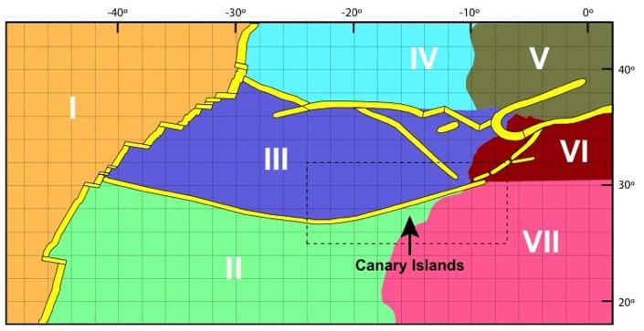
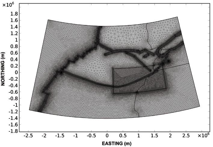
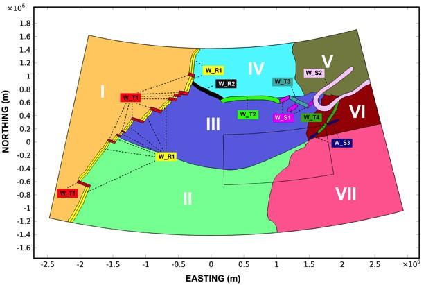
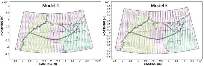
3 METHODOLOGY METHODOLOGY - the computational domain considered comprises between the 18N and 44N parallel and the 50W and 2E meridian --The numerical procedure is based on the finite element technique, with 2-D linear elastic elements in a plane stress approximation - We have modelled the area as a mosaic of poorly deformable zones ( blocks ) (Fig.2 I-VII), separated by highly deformable narrow decoupling zones, where most deformation is accommodated - The nature (compressional, extensional or transcurrent) and geometry of the ``decoupling zones'' have been extracted from previous studies describing the kinematics and neotectonics of the area - To be able to introduce all input data in COMSOL Multiphysics software we have transformed the available information given in geographic coordinates into a Cartesian x-y coordinate system with meters and not degrees as measurement units. For this we have applied a Lambert Conformal Conic projection (LCC) with horizontal datum WGS84. - The area of Figure 1 once projected in LCC is imported in COMSOL and meshed with triangular elements. The grid adopted involves around 112,000 triangles. The size and density of triangles have been chosen on the basis of the complexity of the local tectonic pattern to be reproduced - Each block (Fig. 2 and Fig. 6 I-VII) is characterised by two constants, the Poisson's ratio and the parameter M = E h, where E is the Young's modulus and h is the thickness of the mechanical lithosphere, that in our approximation is the part of the plate that sustains the stresses induced by tectonic forces
4 METHODOLOGY METHODOLOGY
5 BOUNDARY BOUNDARYCONDITIONS CONDITIONS


6 comparing results with reals data for model validation
7


8 The final model Computational domain and material properties of the final model Boundary conditions of the final model
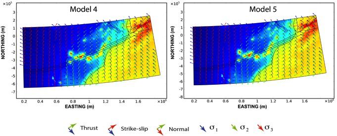
9 CONCLUDING CONCLUDINGREMARKS REMARKS - What we have shown is a 2D model of the geodynamic framework of the Canaries, which is the first step in the construction of a 3D model. The methodology developed here will be easily applicable to other active volcanic areas. - Comparing the model obtained with the existing stress data and distribution of recent volcanism, we observe a perfect coherence between predicted results and geological and geophysical evidence. - Applying this model to the El Hierro eruption it shows a perfect coincidence with the tectonic controls exerted on magma migration during unrest and the eruption site. A similar coincidence can be deduced for the Teneguía eruption (October 1971) in the island of La Palma. - In conclusion, the model (and, in general, similar models for other areas) helps to identify the areas with a highest volcanic susceptibility (highest probability of vent opening), and may be used to forecast the sites of future eruptions
Risk Management. from Volcanoes to Finances. Prof. Joan Martí Institute of Earth Sciences Jaume Almera, CSIC, Barcelona
 Risk Management from Volcanoes to Finances Prof. Joan Martí Institute of Earth Sciences Jaume Almera, CSIC, Barcelona www.gvb-csic.es April 7, 2014 Why to compare volcanoes and finances? Both are systems
Materials and Methods The deformation within the process zone of a propagating fault can be modeled using an elastic approximation.
 Materials and Methods The deformation within the process zone of a propagating fault can be modeled using an elastic approximation. In the process zone, stress amplitudes are poorly determined and much
HASSET A probability event tree tool to evaluate future eruptive scenarios using Bayesian Inference. Presented as a plugin for QGIS.
 HASSET A probability event tree tool to evaluate future eruptive scenarios using Bayesian Inference. Presented as a plugin for QGIS. USER MANUAL STEFANIA BARTOLINI 1, ROSA SOBRADELO 1,2, JOAN MARTÍ 1 1
Causes and mechanisms of the El Hierro (Canary Islands) submarine eruption
 submarine eruption") Causes and mechanisms of the 2011-2012 El Hierro (Canary Islands) submarine eruption J. Marti, Virginie Pinel, Carmen López, Adelina Geyer, Rafael Abella, Marta Tárraga, María José Blanco, Antonio Castro,
Causes and mechanisms of the 2011-2012 El Hierro (Canary Islands) submarine eruption J. Marti, Virginie Pinel, Carmen López, Adelina Geyer, Rafael Abella, Marta Tárraga, María José Blanco, Antonio Castro,
Elastoplastic Deformation in a Wedge-Shaped Plate Caused By a Subducting Seamount
 Elastoplastic Deformation in a Wedge-Shaped Plate Caused By a Subducting Seamount Min Ding* 1, and Jian Lin 2 1 MIT/WHOI Joint Program, 2 Woods Hole Oceanographic Institution *Woods Hole Oceanographic
Workshop on Earthquakes and Volcanoes Barcelona, Hotel AYRE CASPE, 8-9 November, 2016 SCIENTIFIC REPORT
 Workshop on Earthquakes and Volcanoes Barcelona, Hotel AYRE CASPE, 8-9 November, 2016 SCIENTIFIC REPORT 28 scientists from 10 different countries met in hotel AYRE CASPE in Barcelona on November 8 and
Interactive comment on Long-term volcanic hazard assessment on El Hierro (Canary Islands) by L. Becerril et al.
 by L. Becerril et al.") Interactive comment on Long-term volcanic hazard assessment on El Hierro (Canary Islands) by L. Becerril et al. J. Lindsay (Referee) General comments 1. The use of susceptibility map requires further explanation
Interactive comment on Long-term volcanic hazard assessment on El Hierro (Canary Islands) by L. Becerril et al. J. Lindsay (Referee) General comments 1. The use of susceptibility map requires further explanation
COMPOSITION and PHYSICAL PROPERTIES GENERAL SUBJECTS. GEODESY and GRAVITY
 COMPOSITION and PHYSICAL PROPERTIES Composition and structure of the continental crust Composition and structure of the core Composition and structure of the mantle Composition and structure of the oceanic
How does an ellipsoid differ from a sphere in approximating the shape and size of the Earth?
 Chapter 02 Test Bank Worksheet Questions 1. What is a map projection? Topic: Map Projection 2. How does an ellipsoid differ from a sphere in approximating the shape and size of the Earth? Topic: Ellipsoid
Earthquake and Volcano Clustering at Mono Basin (California)
") Excerpt from the Proceedings of the COMSOL Conference 2010 Paris Earthquake and Volcano Clustering at Mono Basin (California) D. La Marra *,1, A. Manconi 2,3 and M. Battaglia 1 1 Dept of Earth Sciences,
Excerpt from the Proceedings of the COMSOL Conference 2010 Paris Earthquake and Volcano Clustering at Mono Basin (California) D. La Marra *,1, A. Manconi 2,3 and M. Battaglia 1 1 Dept of Earth Sciences,
Section 2: How Mountains Form
 Section 2: How Mountains Form Preview Objectives Mountain Ranges and Systems Plate Tectonics and Mountains Types of Mountains Objectives Identify the types of plate collisions that form mountains. Identify
Plate Tectonics and the cycling of Earth materials
 Plate Tectonics and the cycling of Earth materials Plate tectonics drives the rock cycle: the movement of rocks (and the minerals that comprise them, and the chemical elements that comprise them) from
Regional-Scale Salt Tectonics Modelling: Bench-Scale Validation and Extension to Field-Scale Predictions
 Software Limited Bench-Scale to Field-Scale Regional-Scale Salt Tectonics Modelling: Bench-Scale Validation and Extension to Field-Scale Predictions Thornton, Dean A., Roberts, Daniel T., Crook, Anthony
GLY Geomorphology Notes
 GLY 5705 - Geomorphology Notes Dr. Peter N. Adams Revised: Sept. 2012 10 Flexure of the Lithosphere Associated Readings: Anderson and Anderson (2010), pp. 86-92 Here we ask the question: What is the response
Alternative Mechanisms for Volcanic Activity in Hotspot-Ridge Systems: The Northern Galapagos Province
 ABSTRACT for the Plume IV Penrose Conference Alternative Mechanisms for Volcanic Activity in Hotspot-Ridge Systems: The Northern Galapagos Province Karen S. Harpp, Colgate University, Department of Geology,
IAVCEI. Commission on Volcano Geoheritage and Protected Volcanic Landscapes
 IAVCEI Commission on Volcano Geoheritage and Protected Volcanic Landscapes Joan Marti 1; Károly Németh 2, Tom Casadewall 3; Mohammed Rashad Moufti 4, 1 Institute of Earth Sciences "Jaume Almera, CSIC,
Impact Simulation of Extreme Wind Generated Missiles on Radioactive Waste Storage Facilities
 Impact Simulation of Extreme Wind Generated Missiles on Radioactive Waste Storage Facilities Gianluca Barbella Sogin S.p.A. Structural Design Department barbella@sogin.it Rotterdam - october 24, 2013 Outline
Applied Cartography and Introduction to GIS GEOG 2017 EL. Lecture-1 Chapters 1 and 2
 Applied Cartography and Introduction to GIS GEOG 2017 EL Lecture-1 Chapters 1 and 2 What is GIS? A Geographic Information System (GIS) is a computer system for capturing, storing, querying, analyzing and
Chapter 10: Deformation and Mountain Building. Fig. 10.1
 Chapter 10: Deformation and Mountain Building Fig. 10.1 OBJECTIVES Describe the processes of rock deformation and compare and contrast ductile and brittle behavior in rocks. Explain how strike and dip
"Dynamics and structural evolution of collapse calderas: A comparison between field evidence, analogue and mathematical models"
 Tesi doctoral presentada per En/Na Adelina GEYER TRAVER amb el títol "Dynamics and structural evolution of collapse calderas: A comparison between field evidence, analogue and mathematical models" per
HP-35s Calculator Program Lambert 1
 Convert Latitude and Longitude to Lambert Conformal Conic Projection Co-ordinates (SPCS) Programmer: Dr. Bill Hazelton Date: July, 2010. Version: 1.2 Line Instruction Display User Instructions N001 LBL
GPS measurements of current crustal movements along the Gulf of Suez, Egypt.
 GPS measurements of current crustal movements along the Gulf of Suez, Egypt. Presented By Nadia Abo-Ali Assistant Researcher At National Research Institute of Astronomy and Geophysics (NRIAG), Helwan,
Activity Pacific Northwest Tectonic Block Model
 Activity Pacific Northwest Tectonic Block Model The Cascadia tectonic margin is caught between several tectonic forces, during the relentless motions of the giant Pacific Plate, the smaller subducting
Map Projections. Displaying the earth on 2 dimensional maps
 Map Projections Displaying the earth on 2 dimensional maps Map projections Define the spatial relationship between locations on earth and their relative locations on a flat map Are mathematical expressions
Unit 4 Lesson 3 Mountain Building. Copyright Houghton Mifflin Harcourt Publishing Company
 Stressed Out How can tectonic plate motion cause deformation? The movement of tectonic plates causes stress on rock structures. Stress is the amount of force per unit area that is placed on an object.
Lecture 4. Coordinate Systems & Projections
 Lecture 4 Coordinate Systems & Projections Outline Geodesy Geoids Ellipsoids Geographic Coordinate Systems Magnetic North vs. True North Datums Projections Applying Coordinate Systems and Projections Why
Plane coordinates ~~~~~~~~~~
 Coordinate Systems & Map Projections Geographic coordinates A Basic Introduction to Coordinate Systems & Map Projections Latitude & longitude Angles Parallels & meridians Lines Plane coordinates ~~~~~~~~~~
GIS in Water Resources. Fall Homework #1
 GIS in Water Resources Fall 2015 Homework #1 Goal The goal of this homework is to reinforce the lecture material on Geodesy, Map Projections and Coordinate Systems by having you identify attributes and
Name Class Date. 1. What is the outermost layer of the Earth called?. a. core b. lithosphere c. asthenosphere d. mesosphere
 Name Class Date Assessment Geology Plate Tectonics MULTIPLE CHOICE Write the letter of the correct answer in the space provided. 1. What is the outermost layer of the Earth called?. a. core b. lithosphere
FINAL REPORT SI VETOOLS. 1. Objectives, partnership and expected deliverables (summary) 2
 2") MINISTERIO DE ECONOMÍA Y COMPETITIVIDAD SCSÏC ictja INSTITUT OF EARTH SCIENCES JAUME ALMERA (ICTJA) FINAL REPORT SI2.695524 VETOOLS Table of contents: 1. Objectives, partnership and expected deliverables
MINISTERIO DE ECONOMÍA Y COMPETITIVIDAD SCSÏC ictja INSTITUT OF EARTH SCIENCES JAUME ALMERA (ICTJA) FINAL REPORT SI2.695524 VETOOLS Table of contents: 1. Objectives, partnership and expected deliverables
Exercise: mechanics of dike formation at Ship Rock
 Exercise: mechanics of dike formation at Ship Rock Reading: Fundamentals of Structural Geology, Ch. 8, p. 87 95, 319-33 Delaney & Pollard, 1981, Deformation of host rocks and flow of magma during growth
Georeferencing. Place names Postal addresses Postal codes Coordinate systems (lat/long, UTM, etc.)
") Georeferencing Georeferencing Used to describe the act of assigning locations to data or information Certain requirements include that they are: unique, have shared meaning, and are persistent through
Georeferencing Georeferencing Used to describe the act of assigning locations to data or information Certain requirements include that they are: unique, have shared meaning, and are persistent through
GEORED Project: GNSS Geodesy Network for Geodynamics Research in Colombia, South America. Héctor Mora-Páez
 GEORED Project: GNSS Geodesy Network for Geodynamics Research in Colombia, South America. Héctor Mora-Páez Colombian Geological Survey UNAVCO SCIENCE MEETING Feb 27 March 1, 2012 Boulder, CO, TECTONIC
Unit 4 Lesson 7 Mountain Building
 Indiana Standards 7.2.4 Explain how convection currents in the mantle cause lithospheric plates to move causing fast changes like earthquakes and volcanic eruptions, and slow changes like creation of mountains
Chapter 4 Earthquakes and Tsunamis
 Geology of the Hawaiian Islands Class 21 30 March 2004 100 100 100 96 A B C D F Exam Scores 95 94 94 90 85 83 83 83 Mean 72 67 61 59 59 55 54 41 Mean = 78.5 Median = 83 Any Questions? Chapter 4 Earthquakes
Chapter 4 Earthquakes and Tsunamis. Geology of the Hawaiian Islands. Any Questions? Class March Mean = 78.
 Geology of the Hawaiian Islands Class 21 30 March 2004 Any Questions? 100 100 100 96 A B C D F Exam Scores 95 94 94 90 85 83 83 83 Mean 72 67 61 59 59 55 54 41 Mean = 78.5 Median = 83 Chapter 4 Earthquakes
TO DETERMINE YOUNG S MODULUS OF ELASTICITY OF THE MATERIAL OF A BAR BY THE METHOD OF FLEXURE
 TO DETERMINE YOUNG S MODULUS OF ELASTICITY OF THE MATERIAL OF A BAR BY THE METHOD OF FLEXURE Aim: To determine the Young s modulus elasticity the given material. Apparatus: meter, screw gauge, spherometer
Name: Page 1. 2) What do increases and decreases in RSAM data indicate about magma movement inside the volcano?
 What do increases and decreases in RSAM data indicate about magma movement inside the volcano?") Name: Page 1 Living on the Edge Unit 5: SEISMOLOGISTS A report on the seismic activity must be prepared in order to assess and forecast future activity. Complete the following components of the seismology
Name: Page 1 Living on the Edge Unit 5: SEISMOLOGISTS A report on the seismic activity must be prepared in order to assess and forecast future activity. Complete the following components of the seismology
DRAPING SIMULATION. Recent achievements and future trends. Dr. Sylvain Bel LGCIE University Lyon 1
 DRAPING SIMULATION Recent achievements and future trends 1 Dr. Sylvain Bel LGCIE University Lyon 1 2 DRAPING SIMULATION Why? How? What? DRAPING SIMULATION WHY? Clamps Punch Fabric Die 1 2 Resin 3 4 Fig.
Generalized Plane Piezoelectric Problem: Application to Heterostructure Nanowires
 Generalized Plane Piezoelectric Problem: Application to Heterostructure Nanowires H. T. Mengistu and A. Garcia-Cristobal Institute of Material Science, University of Valencia, P.O.Box 22085, E-46071, Valencia,
Previously Documented Basin-localized Extension on Mercury
 GSA DATA REPOSITORY 2012323 Watters et al. Previously Documented Basin-localized Extension on Mercury The most widely distributed extensional landforms on Mercury seen in images from the Mariner 10 and
Finite Element Method in Geotechnical Engineering
 Finite Element Method in Geotechnical Engineering Short Course on + Dynamics Boulder, Colorado January 5-8, 2004 Stein Sture Professor of Civil Engineering University of Colorado at Boulder Contents Steps
Stress equilibrium in southern California from Maxwell stress function models fit to both earthquake data and a quasi-static dynamic simulation
 Stress equilibrium in southern California from Maxwell stress function models fit to both earthquake data and a quasi-static dynamic simulation Peter Bird Dept. of Earth, Planetary, and Space Sciences
Introduction to Displacement Modeling
 Introduction to Displacement Modeling Introduction Deformation on the Earth surface informs us about processes and material properties below surface Observation tools: GPS (static-dynamic) InSAR (static)
Numerical Simulation of the Thermal Convection and Subduction Process in the Mantle
 Chapter 1 Earth Science Numerical Simulation of the Thermal Convection and Subduction Process in the Mantle Project Representative Yoshio Fukao Institute for Research on Earth Evolution, Japan Agency for
Mountains are then built by deforming crust: Deformation & Mountain Building. Mountains form where stresses are high!
 Deformation & Mountain Building Where are mountains located? Deformation and Folding Mountain building Mountains form where stresses are high! Mountains form at all three types of plate boundaries where
Map Projections & Coordinate Systems
 Map Projections & Coordinate Systems 9/7/2017 1 Why? Laying the Earth Flat Need convenient means of measuring and comparing distances, directions, areas, shapes. Traditional surveying instruments measure
How summit calderas collapse on basaltic volcanoes: new insights from the April 2007 caldera collapse of Piton de la Fournaise volcano
 IOP Conference Series: Earth and Environmental Science How summit calderas collapse on basaltic volcanoes: new insights from the April 2007 caldera collapse of Piton de la Fournaise volcano To cite this
1/28/16. EGM101 Skills Toolbox. Oblate spheroid. The shape of the earth Co-ordinate systems Map projections. Geoid
 EGM101 Skills Toolbox Oblate spheroid The shape of the earth Co-ordinate systems Map projections The geoid is the shape that the surface of the oceans would take under the influence of Earth's gravitation
Elastic models of deformation in nature: why shouldn t we use the present day fault geometry?
 Elastic models of deformation in nature: why shouldn t we use the present day fault geometry? B. Freeman 1, G. Yielding, 1 S.J. Dee 1, 2, & P.G. Bretan 1 1 Badley Geoscience Limited, UK 2 BP Exploration
DETAILS ABOUT THE TECHNIQUE. We use a global mantle convection model (Bunge et al., 1997) in conjunction with a
 in conjunction with a") DETAILS ABOUT THE TECHNIQUE We use a global mantle convection model (Bunge et al., 1997) in conjunction with a global model of the lithosphere (Kong and Bird, 1995) to compute plate motions consistent
DETAILS ABOUT THE TECHNIQUE We use a global mantle convection model (Bunge et al., 1997) in conjunction with a global model of the lithosphere (Kong and Bird, 1995) to compute plate motions consistent
SUPPLEMENTARY INFORMATION
 SUPPLEMENTARY INFORMATION doi: 10.1038/ngeo739 Supplementary Information to variability and distributed deformation in the Marmara Sea fault system Tobias Hergert 1 and Oliver Heidbach 1,* 1 Geophysical
Tectonic Forces Simulation: Volcanoes Activity One
 Tectonic Forces Simulation: Volcanoes Activity One Introduction Volcanoes form above vents or cracks in the earth's crust. When a volcano erupts, magma is forced up through the cracks - sending lava, ash,
Analytical and Computer Cartography Lecture 3: Review: Coordinate Systems
 Analytical and Computer Cartography Lecture 3: Review: Coordinate Systems Geographic Coordinates NAD83 NAD27 remained in use until the earthcentered international GRS80 was complete (Geodetic Reference
Layer Composition Thickness State of Matter
 Unit 4.2 Test Review Earth and Its Layers 1. Label the layers of the earth. oceanic crust continental crust lithosphere asthenosphere mantle outer core inner core 2. Complete the Following Table about
Gravity Tectonics Volcanism Atmosphere Water Winds Chemistry. Planetary Surfaces
 Gravity Tectonics Volcanism Atmosphere Water Winds Chemistry Planetary Surfaces Gravity & Rotation Polar flattening caused by rotation is the largest deviation from a sphere for a planet sized object (as
Lecture 2. Map Projections and GIS Coordinate Systems. Tomislav Sapic GIS Technologist Faculty of Natural Resources Management Lakehead University
 Lecture 2 Map Projections and GIS Coordinate Systems Tomislav Sapic GIS Technologist Faculty of Natural Resources Management Lakehead University Map Projections Map projections are mathematical formulas
Mohr's Circle and Earth Stress (The Elastic Earth)
") Lect. 1 - Mohr s Circle and Earth Stress 6 Mohr's Circle and Earth Stress (The Elastic Earth) In the equations that we derived for Mohr s circle, we measured the angle, θ, as the angle between σ 1 and
Lect. 1 - Mohr s Circle and Earth Stress 6 Mohr's Circle and Earth Stress (The Elastic Earth) In the equations that we derived for Mohr s circle, we measured the angle, θ, as the angle between σ 1 and
What is the threat? Sue Loughlin and Julia Crummy British Geological Survey. NERC All rights reserved NERC All rights reserved
 What is the threat? Sue Loughlin and Julia Crummy British Geological Survey BATA Conference, London 15 th October 2013 What is a volcano? Where and how many? There are more than 1500 known potentially
EOS 350 MIDTERM OCT 4, 2013 STUDENT NAME: TEAM #:
 EOS 350 MIDTERM OCT 4, 2013 STUDENT NAME: TEAM #: Some equations which may, or may not, be useful: Distance from sensor to a dipole z ~ x ½, Distance to line of dipoles z ~ 0.75x ½ B = μh, M = κh Seismic
Continuum mechanism: Plates
 Observations of plate tectonics imply that the thin near-surface rocks, that constitute the lithosphere, are rigid, and therefore behave elastically on geological time scales. From the observed bending,
Title: Exact wavefield extrapolation for elastic reverse-time migration
 Title: Exact wavefield extrapolation for elastic reverse-time migration ummary: A fundamental step of any wave equation migration algorithm is represented by the numerical projection of the recorded data
Chapter 2 Plate Tectonics and the Ocean Floor
 Chapter 2 Plate Tectonics and the Ocean Floor Matching. Match the term or person with the appropriate phrase. You may use each answer once, more than once or not at all. 1. hydrothermal vents A. convergent
Watershed Sciences 4930 & 6920 GEOGRAPHIC INFORMATION SYSTEMS
 PROJECTS Watershed Sciences 4930 & 6920 GEOGRAPHIC INFORMATION SYSTEMS WEEK THREE Lecture 5 PROJECT DATA/IDEAS, PROJECTIONS (Cont.) & LAB REVIEW Joe Wheaton GUEST LECTURE HOUSEKEEPING: LAB 01 GRADES This
DOWN-HOLE SEISMIC SURVEY AND VERTICAL ELECTRIC SOUNDINGS RABASKA PROJECT, LÉVIS, QUÉBEC. Presented to :
 DOWN-HOLE SEISMIC SURVEY AND VERTICAL ELECTRIC SOUNDINGS RABASKA PROJECT, LÉVIS, QUÉBEC Presented to : TERRATECH 455, René-Lévesque Blvd. West Montreal, Québec HZ 1Z3 Presented by : GEOPHYSICS GPR INTERNATIONAL
Projections Part I - Categories and Properties James R. Clynch February 2006
 I. Introduction and References Projections Part I - Categories and Properties James R. Clynch February 2006 The world is, approximately, a sphere. Maps are flat. Making maps requires some method of putting
Chapter 7 Plate Tectonics. Plate tectonics accounts for important features of Earth s surface and major geologic events.
 Chapter 7 Plate Tectonics Plate tectonics accounts for important features of Earth s surface and major geologic events. 7-2 Alfred Wegener s Hypothesis of Continental Drift (1915) He noticed that the continents
Ch12&13 Test. 3. Where does the first motion of an earthquake occur? a. fault c. epicenter b. focus d. locus
 Ch12&13 Test Multiple Choice Identify the choice that best completes the statement or answers the question. 1. What is the epicenter of an earthquake? a. the location along a fault where the first motion
Structural Modelling of Inversion Structures: A case study on South Cambay Basin
 10 th Biennial International Conference & Exposition P 065 Structural Modelling of Inversion Structures: A case study on South Cambay Basin Dr. Mayadhar Sahoo & S.K Chakrabarti Summary The inversion in
Simulated and Observed Scaling in Earthquakes Kasey Schultz Physics 219B Final Project December 6, 2013
 Simulated and Observed Scaling in Earthquakes Kasey Schultz Physics 219B Final Project December 6, 2013 Abstract Earthquakes do not fit into the class of models we discussed in Physics 219B. Earthquakes
Working with georeferenced data. What is georeferencing? Coordinate Systems. Geographic and Projected Coordinate System
 GIS501 Fundamentals of Geographical Information Systems (GIS) Coordinate Systems Working with georeferenced data What is georeferencing? Geographically referenced data which is, in some way, referenced
This week s topics. Week 6. FE 257. GIS and Forest Engineering Applications. Week 6
 FE 257. GIS and Forest Engineering Applications Week 6 Week 6 Last week Chapter 8 Combining and splitting landscape features and merging GIS databases Chapter 11 Overlay processes Questions? Next week
Surface changes caused by erosion and sedimentation were treated by solving: (2)
") GSA DATA REPOSITORY 214279 GUY SIMPSON Model with dynamic faulting and surface processes The model used for the simulations reported in Figures 1-3 of the main text is based on two dimensional (plane strain)
GSA DATA REPOSITORY 214279 GUY SIMPSON Model with dynamic faulting and surface processes The model used for the simulations reported in Figures 1-3 of the main text is based on two dimensional (plane strain)
} based on composition
 Learning goals: Predict types of earthquakes that will happen at different plate boundaries based on relative plate motion vector vs. strike (vector subtraction) Understand interseismic and coseismic deformation,
MIGRATING SWARMS OF BRITTLE-FAILURE EARTHQUAKES IN THE LOWER CRUST BENEATH MAMMOTH MOUNTAIN, CALIFORNIA
 MIGRATING SWARMS OF BRITTLE-FAILURE EARTHQUAKES IN THE LOWER CRUST BENEATH MAMMOTH MOUNTAIN, CALIFORNIA David Shelly and David Hill GRL, October 2011 Contents Tectonic Setting Long Valley Caldera Mammoth
PETROLEUM GEOSCIENCES GEOLOGY OR GEOPHYSICS MAJOR
 PETROLEUM GEOSCIENCES GEOLOGY OR GEOPHYSICS MAJOR APPLIED GRADUATE STUDIES Geology Geophysics GEO1 Introduction to the petroleum geosciences GEO2 Seismic methods GEO3 Multi-scale geological analysis GEO4
1. Geospatial technology rarely links geospatial data to nonspatial data. a. True *b. False
 Chapter 2 Where in the Geospatial World Are You? 1. Geospatial technology rarely links geospatial data to nonspatial data. 2. For geospatial technology to work, every location on Earth must be: a. inhabited
John Browning and Agust Gudmundsson
 Surface displacements resulting from magma-chamber roof subsidence, with application to the 2014-2015 Bardarbunga- Holuhraun volcanotectonic episode in Iceland John Browning and Agust Gudmundsson Royal
Full file at
 Essentials of Oceanography, 10e (Trujillo/Keller) Chapter 2 Plate Tectonics and the Ocean Floor Match the term with the appropriate phrase. You may use each answer once, more than once or not at all. A)
Back Calculation of Rock Mass Modulus using Finite Element Code (COMSOL)
") Back Calculation of Rock Mass Modulus using Finite Element Code (COMSOL) Amirreza Ghasemi 1. Introduction Deformability is recognized as one of the most important parameters governing the behavior of rock
Back Calculation of Rock Mass Modulus using Finite Element Code (COMSOL) Amirreza Ghasemi 1. Introduction Deformability is recognized as one of the most important parameters governing the behavior of rock
The Santorini Inflation Episode, Monitored by InSAR and GPS
 The Santorini Inflation Episode, Monitored by InSAR and GPS Ioannis Papoutsis 1,2, Xanthos Papanikolaou 2, Michael Floyd 3, Kang Hyeun Ji 4, Charalampos Kontoes 1, Demitris Paradissis 2, Demitris Anastasiou
PROANA A USEFUL SOFTWARE FOR TERRAIN ANALYSIS AND GEOENVIRONMENTAL APPLICATIONS STUDY CASE ON THE GEODYNAMIC EVOLUTION OF ARGOLIS PENINSULA, GREECE.
 PROANA A USEFUL SOFTWARE FOR TERRAIN ANALYSIS AND GEOENVIRONMENTAL APPLICATIONS STUDY CASE ON THE GEODYNAMIC EVOLUTION OF ARGOLIS PENINSULA, GREECE. Spyridoula Vassilopoulou * Institute of Cartography
Interactive 3D Sketchupbook
 THE UNIVERSITY OF SYDNEY - SCHOOL OF GEOSCIENCES Interactive 3D Sketchupbook Patrice F. Rey CHAPTER 1 Orienting Planes and Lines 1 Interactive 1.1 Strike, dip and dip direction In a 3D space, planar surfaces
Students will be able, using GIS, to locate the largest and most destructive earthquakes;
 Exploring Earthquake Hazards with GIS Laboratory for Introduction to Geophysics, Spring 2007 Prof. Constantin Cranganu Brooklyn College of the City University of New York Learning Objectives: Students
GEODETIC EVIDENCE FOR SLOW INFLATION OF THE SANTORINI CALDERA
 Proceedings, 11 th FIG Symposium on Deformation Measurements, Santorini, Greece, 2003. GEODETIC EVIDENCE FOR SLOW INFLATION OF THE SANTORINI CALDERA Stathis Stiros 1, Aris Chasapis 2 and Villy Kontogianni
Map Projections. What does the world look like? AITOFF AZIMUTHAL EQUIDISTANT BEHRMANN EQUAL AREA CYLINDRICAL
 Map Projections What does the world look like? AITOFF AZIMUTHAL EQUIDISTANT BEHRMANN EQUAL AREA CYLINDRICAL 1 CYLINDRICAL EQUAL AREA BONNE CRASTER PARABOLIC 2 ECKERT I ECKERT III ECKERT V There are many
Content. Department of Mathematics University of Oslo
 Chapter: 1 MEK4560 The Finite Element Method in Solid Mechanics II (January 25, 2008) (E-post:torgeiru@math.uio.no) Page 1 of 14 Content 1 Introduction to MEK4560 3 1.1 Minimum Potential energy..............................
Analytical model of surface uplift above axisymmetric flat-lying magma intrusions: Implications for sill emplacement and geodesy
 Author manuscript, published in "Journal of Volcanology and Geothermal Research 253 (2013) 114-130" DOI : 10.1016/j.jvolgeores.2012.12.006 Analytical model of surface uplift above axisymmetric flat-lying
Tdyn-CFD+HT - Validation Case 9
 Two-dimensional heat conduction with heat generation Version 14.0.0 Compass Ingeniería y Sistemas http://www.compassis.com Tel.: +34 932 181 989 - Fax.: +34 933 969 746 - E: info@compassis.com - C/ Tuset
Website Lecture 4 The Physical Environment Continued
 Website http://websites.rcc.edu/halama Lecture 4 The Physical Environment Continued 1 Lecture 4 1. Weather and Climate Global Local 2. Internal Planetary Processes Layers Plate Tectonics Earthquakes Volcanos
Directed Reading. Section: Volcanoes and Plate Tectonics
 Skills Worksheet Directed Reading Section: Volcanoes and Plate Tectonics 1. What can cause some of the most dramatic changes to Earth s surface? a. solar activity b. tides c. geysers d. volcanic eruptions
LEADS. The Essential Elements of a 3-D Geographic Coordinate
 The Essential Elements of a 3-D Geographic Coordinate John W. Dix 13 September 2005 ESRI Homeland Security GIS Summit - Denver, CO John.W.Dix@nga.mil NATIONAL GEOSPATIAL-INTELLIGENCE AGENCY Overview is
Subject Classification
 Istituto Nazionale di Geofisica e Vulcanologia earth-prints home page roma library bologna library catania library milano library napoli library palerm Subject Classification Earth-prints organize its
Yellowstone Hotspot Component of the Plate Boundary Observatory
 Yellowstone Hotspot Component of the Plate Boundary Observatory (Investigators: Smith, Thatcher, Meertens, Humphreys, Dzurisin, Oldow Co-Investigators: Christiansen, Doss, Schwartz, Machette, Wong, Olig,
The influence of short wavelength variations in viscosity on subduction dynamics
 1 Introduction Deformation within the earth, driven by mantle convection due primarily to cooling and subduction of oceanic lithosphere, is expressed at every length scale in various geophysical observations.
PLATE TECTONICS REVIEW GAME!!!!
 PLATE TECTONICS REVIEW GAME!!!! Name the four layers of the earth - crust - mantle - outer core - inner core Which part of Earth s structure contains tectonic plates? LITHOSPHERE Name one reason why the
D DAVID PUBLISHING. Deformation of Mild Steel Plate with Linear Cracks due to Horizontal Compression. 1. Introduction
 Journal of Control Science and Engineering 1 (2015) 40-47 doi: 10.17265/2328-2231/2015.01.005 D DAVID PUBLISHING Deformation of Mild Steel Plate with Linear Cracks due to Horizontal Compression Mitsuru
NEW ZEALAND EARTHQUAKES AND PLATE
 87 NEW ZEALAND EARTHQUAKES AND PLATE TECTONIC THEORY R.I. Walcott * ABSTRACT The rates and direction of shear strain from geodetic data and the direction of slip from earthquake mechanism studies in New
From Punchbowl to Panum: Long Valley Volcanism and the Mono-Inyo Crater Chain
 From Punchbowl to Panum: Leslie Schaffer E105 2002 Final Paper Long Valley Volcanism and the Mono-Inyo Crater Chain Figure 1. After a sequence of earthquakes during the late 1970 s to the early 1980 s
Back Analysis of Measured Displacements of Tunnels
 Rock Mechanics and Rock Engineering 16, 173--180 (1983) Rock Mechanics and Rock Engineering 9 by Springer-Verlag 1983 Back Analysis of Measured Displacements of Tunnels By S. Sakurai and K. Takeuchi Kobe