Airport Wildlife Strike Hazard Management
|
|
|
- Laurence Stokes
- 5 years ago
- Views:
Transcription
1 Airport Wildlife Strike Hazard Management November 2005 Program Review Edwin E. Herricks University of Illinois Center of Excellence and FAA WSM-R (AAR 411)
2 From: FAA Flight Plan The FAA will continue to develop technologies that will utilize the United States airspace in safer, more efficient, and more environmentally sound ways. We will improve our risk management practices by collecting and analyzing data to identify problems and prevent accidents from occurring. We will continue to partner with industry to reduce the commercial accident rate, improve runway safety, and extend the excellent safety record of commercial space transportation
3 The system can be defined with an aircraft focus

4 But we can t ignore the rest of the system, including wildlife!
5 The Wildlife Strike Management Program (WSMP) is developing methods to improve operational safety through a multifaceted program that emphasizes systems integration.
6 2005 CEAT Wildlife Program Landside management: Systems Development (WHAS) w/ GIS base (AOA to Regional Scale) National Scale Integration Infomatics/Information Technology Integration of advanced detection and modeling for hazard/risk warnings Radar FOD and Bird radar demonstrations

7 The system is three dimensional, focused on aircraft movement.

8 The systems approach must consider more than the AOA. With an airport focus, the system considers aircraft and wildlife movement and the potential for interaction regionally. Approach paths at DFW, 10X vertical exaggeration Green plane indicates 3,000 feet AGL
9 To deal with wildlife hazards the systems approach utilizes multiple data resources, uses existing ecological information, and considers modeling to provide a spatial and temporal integration. In the WHMP, one research area is the development of GIS-based technologies to support efforts to better understand wildlife and provide a platform for 3-d integration of both aircraft and wildlife information.
10 Why Use GIS? Mapping Displays information in a visual format that is easier for people to interpret Legal document Maps and reports can be used as historical and/or legal documents Analysis Data can be analyzed in a similar method to Excel or Access
11 Mapping
12
13


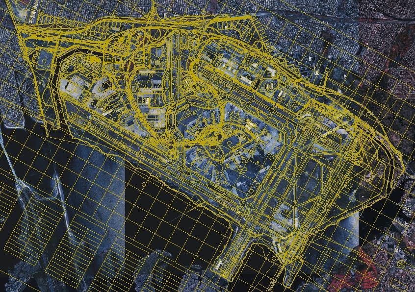
14

15

16
17

18


19 ...but GIS is more than just mapping!
20 Analysis
21 Analysis example from JFK
22 Strike Rate Analysis Overall strike rate Strike rate per runway Annual strike rates per runway Monthly / seasonal strike rates per runway Species specific strike rates Strike locations
23 2001
24 2002

25 2003
26 Strike rate by runway

27 Strike rate with strike location
28 We have also been working with other airports on GIS development. SEA where movement modeling and pilot warning is the focu ORD where basic GIS and integration with OMP.

29


30 Notice the impact of the Des Plaines River Corridor and analysis at various spatial scales Analysis of Local and Regional Data


31 New insights for into water and wetland locations of large bird hazards Analysis of Local and Regional Data


32 Some of the detail has been lost in exporting this photo Notice the pond which already produces wildlife challenges

33 All data can be easily identified

34 We have also been able to relate observations to expert opinion to begin the process of modeling movement. This developing capability will support better hazard assessment that is time and location specific. Blackbird routes, overlayed with their wildlife patrol records.

35 Integrated with GIS we also use advanced technologies, such as radar Using radar detection information we identified ty;pical routes. The north bird route has been used in simulation. End points are illustrated in the graph. Starting point (683070, ) Ending point (682653, )
36 Simulated bird movement Parameters used in the simulation: Initial location: (683070, ,2) meters; Flight destination: (682653, , Z)*; *As ending of the flight is not simulated, Z is not set. Total mass: 500 birds* 0.5kg/bird; Speed: 8 m/s; Flying attitude:50m; Initial dimension: 16*36*4 m3 elliptical-sphere-shaped; End dimension in the simulation: 20*8*8 m3 elliptical-sphere-shaped; 50sec has been simulated in total while the reconfiguration of the flock takes 20sec. *Mass distribution is also considered. As will be shown later, larger sized dots are used for denser mass.

37 Flight phase simultion take off 2D Results Green dots illustrate the results in 2 dimension. Parameters used in the model are listed on the next page.


38 3D results
39 Hazard Assessment The results from the simulation, combined with aircraft and flight information, can provide an approach for hazard assessment.

40 The red dot shows the center of the plane, and the plane is simplified as a long rectangular block, which is orientated long its velocity. Blue dots stand for a flock, which is simplified as rectangle. Mass distribution is not considered.

41

42 Hazard Assessment
 to account for aircraft shape and size the mass-based hazard can be predicted!")
43 Mass involved in the strike is then predicted. This is illustrated below, the missing part of the flock indicates is the #/mass involved in the collision. If using several component (e.g. multiple rectangular blocks) to account for aircraft shape and size the mass-based hazard can be predicted!.
44 The continuing challenge of the systems approach is to provide the integration of information over local to national scales to: improve AOA wildlife habitat management better understand how hazards develop and how hazards can be managed To provide adequate warning of hazard in a form that can be readily used by everyone involved in aircraft operations.
45 To address this issue, the CEAT program is developing a capability to provide real-, or near real-time warnings of wildlife movement based on advanced detection technologies. The program is developing a radar detection capacity, focused on birds at AOA level. The program also recognizes that simple detection is inadequate, we must develop a capacity to convey hazard information quickly and effectively!
46 A recent activity is supporting the USAF/FAA development of a bird specific radar. BIRDAR is a 94 ghz radar developed by Waveband Corp.


47 The radar is relatively short range designed to provide information in the critical phases of landing and take-off. Coverage of a 94 ghz radar developed for the FAA in relation to the glide slope signal that defines expected aircraft path.
48 Bird Strike Hazard Radar Requirement Cumulative Percent of Strikes Most Strikes Occur Near Airports! 2000 AGL Radar Volume 1000 ft. AGL 0 5 nm or 9.3 km
49 In demonstrations of the radar in 2004 and 2004 BIRDAR detected blackbird flocks, to a range of approximately 1.4 km and for single soaring birds to 1.2 km and Canada geese at > 3 km.
50

51 This is what is shown on the screen

52 This is the radar record displayed to show spatial relationships
53 To place this in the context of aircraft movement, the following was observed during the test campaign at DFW.

54

55
56 To meet the objective of an integration of national, regional, and local data in a information system to serve the pilot in command the 2005 progam is developing new information display approaches. For example, a partnership is being negotiated with JetBlue Airlines with the intent of achieving a seamless integration of Program elements with their laptop based aircraft management system
57 A recent development is a cooperative effort with the USAF GIS GIS Support Center, Institute for Information Technology Applications at the USAF Academy to use Google Earth as a platform for this effort
58 We have also supported demonstration and evaluation of other radars. In January 2005 we supported the demonstration of a FOD detection radar at JFK.
59 FOD Radar Testing at JFK FOD is any substance, debris, or article alien to the vehicle or system would potentially cause damage. Foreign object damage is any damage attributed to a foreign object that can be expressed in physical or economic terms which may or may not degrade the required safety and/or performance characteristics of aircraft.
60 FOD items placed on runway to evaluate the radars ability to detect them Both winter pavement (ice and snow) and normal conditions were tested

61 Tests were conducted at different distances to complete an evaluation matrix.
62 FUTURES? CEAT will continue to provide research support to the FAA in the WMHP, Expected areas of emphasis will be radar, radar integration with modeling, developing GIS technologies, and regional/national scale integration of WHMP.

63 Questions?????
64
65
66
67
68
69
70
71
72
73
74
75
76
77
78
79
80
Application of GIS Technologies to Wildlife Management at DFW Airport
 University of Nebraska - Lincoln DigitalCommons@University of Nebraska - Lincoln 2003 Bird Strike Committee USA/Canada, 5th Joint Annual Meeting, Toronto, ONT Bird Strike Committee Proceedings August 2003
The Avian Hazard Advisory System
 101 The Avian Hazard Advisory System T. Adam Kelly a, Ronald Merritt a, Maj Thomas J. Donalds b and Ronald L. White a a 3160 Airport Rd, Suite 22-A, Panama City, FL, 32405 b 4th Wing, Seymour Johnson AFB,
BIRD STRIKE AS AN ENGINEERING PROBLEM
 BIRD STRIKE AS AN ENGINEERING PROBLEM Yasushi Takeda, Prof. Dr. 1,2 Yuichi Murai, Prof. Dr. 1 1 Graduate School of Engineering, Hokkadio University, Sapporo, Japan 2 Solution Science Research Laboratory,
FLYSAFE Bird strike risk mitigation in aviation
 FLYSAFE Bird strike risk mitigation in aviation Arie Dekker Command Mission Support Branche Nature Bureau Serge Sorbi Belgian Air Force Aviation Safety Directorate Wildlife Hazard Management Integrated
INTERNATIONAL BIRD STRIKE COMMITTEE Amsterdam, April 2000
 INTERNATIONAL BIRD STRIKE COMMITTEE IBSC25/WP-RS5 Amsterdam, 17-21 April 2000 THE AVIAN HAZARD ADVISORY SYSTEM (AHAS): OPERATIONAL USE OF WEATHER RADAR FOR REDUCING BIRD STRIKE RISK IN NORTH AMERICA. T
JINFENG WANG THESIS. Urbana, Illinois. Adviser: Professor Edwin E Herricks
 2012 Jinfeng Wang BIRD STRIKE RISK ASSESSMENT AT COMMERCIAL AIRPORTS: SUB-MODEL DEVELOPMENT ACCOUNTING FOR STRIKE OCCURRENCE AND SEVERITY WITH STRIKE CONTRIBUTORY FACTORS BY JINFENG WANG THESIS Submitted
Traffic and Weather. Soaring Safety Foundation. Tom Johnson CFIG
 Traffic and Weather Soaring Safety Foundation Tom Johnson CFIG Weather Contents Weather Gathering Sources Weather Acquisition Enroute Weather Analysis Weather Hazards Weather in the Landing Pattern Basic
Winter-Weather Forecast Research
 Winter-Weather Forecast Research Dr. Jennifer Bewley 23 April 2014 AvMet Applications, Inc. 1800 Alexander Bell Dr., Ste. 130 Reston, 1 VA 20191 Number of Hours with Wintry Precipitation November 2013
Edmonton International Airport
 Edmonton International Airport ZVL Airside Operations Winter Operations Program 2012/13 September 10, 2012 ZVL_pla.dgn Default 12/17/07 5:10:28 PM AIRSIDE WINTER OPERATIONS PROGRAM (AER-002P) DISTRIBUTION/REVISION
Transparency: Redoubt ash cloud
 Module 1 Investigation 3 Transparency: Redoubt ash cloud Aerial view of Redoubt Volcano during a continuous, low-level eruption of steam and ash December 18, 1989 Source: photo by W. White, USGS, http://www.avo.alaska.edu/avo3/volc/redou/photo.htm
NJ SURVEYORS CONFERENCE
 NJ SURVEYORS CONFERENCE PART 107 Ground School TODAY S AGENDA Regulations National Airspace System Operations Weather Loading and Performance 1 REGULATIONS Remote Pilot Certifications and Privileges When
Edmonton International Airport
 Edmonton International Airport ZVL Airside Operations Winter Operations Program 2017/18 September, 2017 AIRSIDE WINTER OPERATIONS PROGRAM (AER-002P) DISTRIBUTION/REVISION LIST Distribution Edmonton Airports
Weather Technology in the Cockpit (WTIC) Shortfall Analysis of Weather Information in Remote Airspace Friends and Partners of Aviation Weather Summer
 Shortfall Analysis of Weather Information in Remote Airspace Friends and Partners of Aviation Weather Summer") Weather Technology in the Cockpit (WTIC) Shortfall Analysis of Weather Information in Remote Airspace Friends and Partners of Aviation Weather Summer Meeting Tim Myers Metron Aviation August 26, 2015 2
Weather Technology in the Cockpit (WTIC) Shortfall Analysis of Weather Information in Remote Airspace Friends and Partners of Aviation Weather Summer Meeting Tim Myers Metron Aviation August 26, 2015 2
ICAO, World Birdstrike Association & CARSAMPAF Mexico City October 2014
 ICAO, World Birdstrike Association & CARSAMPAF Mexico City 20-24 October 2014 Henrique Oliveira¹ & Tarcísio Abreu² Aeronautical Accidents Investigation and Prevention Center Brasília University ¹birdstrike@cenipa.aer.mil.br
ADL110B ADL120 ADL130 ADL140 How to use radar and strike images. Version
 ADL110B ADL120 ADL130 ADL140 How to use radar and strike images Version 1.00 22.08.2016 How to use radar and strike images 1 / 12 Revision 1.00-22.08.2016 WARNING: Like any information of the ADL in flight
CIVIL PROTECTION AND SAFE SKY
 CIVIL PROTECTION AND SAFE SKY DURING THE SPACE VEHICLES REENTRY DeCAS PATENTED An alert system for the safety of people and things on the Earth s surface and for the safety of aircraft and space vehicles
Small UAS Well Clear
 Small UAS Well Clear Andrew Weinert 8 December 2016 EXCOM/SARP Multi-agency collaborative sponsorship FAA POC: Sabrina Saunders-Hodge, UAS Integration Office Research Division (AUS-300) DISTRIBUTION STATEMENT
NEWS RELEASE. Province boosts winter highway safety measures
 For Immediate Release 2018TRAN0045-000567 April 4, 2018 NEWS RELEASE Province boosts winter highway safety measures VICTORIA Following an intense winter, the is undertaking several improvements to make
Weather Considerations for UAS Integration
 Weather Considerations for UAS Integration Scot Campbell 8 December 2016 Sponsor: Steve Abelman, ANG-C6 DISTRIBUTION STATEMENT A. Approved for public release: distribution unlimited. Legal Notices This
NCAR UCAR. 50 th Anniversary Lecture
 NCAR & UCAR 50 th Anniversary Lecture Turbulence, Wind Shear, Toxin Attacks, and Other Things That Go Bump In the Night: Applied Research for Real-Life Problems Bill Mahoney National Center for Atmospheric
Edmonton International Airport YXD City Centre Airport
 Table of Contents Edmonton International Airport YXD City Centre Airport Airside Operations Winter Operations Program 2012/13 September 10, 2012 Table of Contents AIRSIDE WINTER OPERATIONS PROGRAM (AER-002P)
8.7 Calculation of windshear hazard factor based on Doppler LIDAR data. P.W. Chan * Hong Kong Observatory, Hong Kong, China
 8.7 Calculation of windshear hazard factor based on Doppler LIDAR data P.W. Chan * Hong Kong Observatory, Hong Kong, China Paul Robinson, Jason Prince Aerotech Research 1. INTRODUCTION In the alerting
Example of Aircraft Climb and Maneuvering Performance. Dr. Antonio A. Trani Professor
 Example of Aircraft Climb and Maneuvering Performance CEE 5614 Analysis of Air Transportation Systems Dr. Antonio A. Trani Professor Example - Aircraft Climb Performance Aircraft maneuvering performance
Geospatial Data, Services, and Products. National Surveying, mapping and geospatial conference
 Geospatial Data, Services, and Products Federal Programs -- USDA NRCS National Surveying, mapping and geospatial conference March 15, 2016 NRCS Applications using Geosaptial Products & Services Field
An overview of the applications for early warning and mapping of the flood events in New Brunswick
 Flood Recovery, Innovation and Reponse IV 239 An overview of the applications for early warning and mapping of the flood events in New Brunswick D. Mioc 1, E. McGillivray 2, F. Anton 1, M. Mezouaghi 2,
Learning. Goals. of pressure. aircraft. Altimeter knob. Page 1 of 8. Document : V1.1
 LEVELS AND ALTITUDES Learning Goals LEVELS AND ALTITUDES In aviation it is of the utmost importance that a pilot knows his height above ground level for safe landing and obstacle avoidance. For air traffic
INTEGRATING IMPROVED WEATHER FORECAST DATA WITH TFM DECISION SUPPORT SYSTEMS Joseph Hollenberg, Mark Huberdeau and Mike Klinker
 INTEGRATING IMPROVED WEATHER FORECAST DATA WITH TFM DECISION SUPPORT SYSTEMS Joseph Hollenberg, Mark Huberdeau and Mike Klinker The MITRE Corporation Center for Advanced Aviation System Development (CAASD)
Acquisition of Multi-Function Equipment at DIA: Conditions, Factors, Considerations & Integration. Presented by Mike Carlson September 20, 2012
 Acquisition of Multi-Function Equipment at DIA: Conditions, Factors, Considerations & Integration Presented by Mike Carlson September 20, 2012 1 Denver International Airport 5 Runways 12,000 /. (3,658m)
WSI Pilotbrief Optima - for ipad
 WSI Pilotbrief Optima - for ipad Anticipate, Visualize & Avoid Hazardous Weather In A Whole New Way The Weather Company, an IBM Business, delivers an ipad-based version of WSI Pilotbrief Optima. This ipad
July 13, 2017 Session #1 In Lieu of the Surface Observation Including EWINS Authority, RTMA, Web Cams, and Remote Observation Systems
 July 13, 2017 Session #1 In Lieu of the Surface Observation Including EWINS Authority, RTMA, Web Cams, and Remote Observation Systems Part 121 Operator Perspective: Equivalent Level of Safety Using Remote
Flooding Performance Indicator Summary. Performance indicator: Flooding impacts on riparian property for Lake Ontario and the Upper St.
 Flooding Performance Indicator Summary Performance indicator: Flooding impacts on riparian property for Lake Ontario and the Upper St. Lawrence River Technical Workgroup: Coastal TWG Research by: Baird
P1.1 THE NATIONAL AVIATION WEATHER PROGRAM: AN UPDATE ON IMPLEMENTATION
 P1.1 THE NATIONAL AVIATION WEATHER PROGRAM: AN UPDATE ON IMPLEMENTATION Thomas S. Fraim* 1, Mary M. Cairns 1, and Anthony R. Ramirez 2 1 NOAA/OFCM, Silver Spring, MD 2 Science and Technology Corporation,
HEIGHT ALTITUDE FLIGHT LEVEL
 HEIGHT ALTITUDE FLIGHT LEVEL 1. Definition There are several ways to indicate the vertical position of aircraft and/or obstacles; each has another meaning and is used in a particular situation: 2. Units
National Transportation Safety Board Aviation Accident Final Report
 National Transportation Safety Board Aviation Accident Final Report Location: Elk City, OK Accident Number: Date & Time: 02/03/2014, 2300 CST Registration: N61YP Aircraft: CESSNA 525 Aircraft Damage: Substantial
Montréal, 7 to 18 July 2014
 INTERNATIONAL CIVIL AVIATION ORGANIZATION WORLD METEOROLOGICAL ORGANIZATION MET/14-WP/34 28/5/14 Meteorology (MET) Divisional Meeting (2014) Commission for Aeronautical Meteorology Fifteenth Session Montréal,
Prediction of Top of Descent Location for Idle-thrust Descents
 Prediction of Top of Descent Location for Idle-thrust Descents Laurel Stell NASA Ames Research Center Background 10,000 30,000 ft Vertical profile from cruise to meter fix. Top of Descent (TOD) idle thrust
City of Camrose Winter Road Maintenance Policy
 City of Camrose Winter Road Maintenance Policy The purpose of this policy is to outline the level of service that the City of Camrose delivers regarding the maintenance of roads in winter conditions. 1.
Helicopter-triggered lightning strike forecasting
 Helicopter-triggered lightning strike forecasting Jonathan Wilkinson CAA Helicopter Safety Research Management Committee 21 May 2013 Crown copyright Met Office Contents This presentation covers the following
Human Factors Assessment of Runway Status Lights (RWSL) and Final Approach Runway Occupancy Signal (FAROS) Maria Picardi Kuffner
 and Final Approach Runway Occupancy Signal (FAROS) Maria Picardi Kuffner") Human Factors Assessment of Runway Status Lights (RWSL) and Final Approach Runway Occupancy Signal (FAROS) FAA Operational Evaluations at Dallas Ft. Worth and San Diego International Airports Maria Picardi
Human Factors Assessment of Runway Status Lights (RWSL) and Final Approach Runway Occupancy Signal (FAROS) FAA Operational Evaluations at Dallas Ft. Worth and San Diego International Airports Maria Picardi
Remote Sensing Techniques for Renewable Energy Projects. Dr Stuart Clough APEM Ltd
 Remote Sensing Techniques for Renewable Energy Projects Dr Stuart Clough APEM Ltd What is Remote Sensing? The use of aerial sensors to detect and classify objects on Earth Remote sensing for ecological
Appendix E Guidance for Shallow Flooding Analyses and Mapping
 Appendix E Guidance for Shallow Flooding Analyses and Mapping E.1 Introduction Different types of shallow flooding commonly occur throughout the United States. Types of flows that result in shallow flooding
The known requirements for Arctic climate services
 The known requirements for Arctic climate services based on findings described in STT White paper 8/2015 Johanna Ekman / EC PHORS STT Regional drivers The Arctic region is home to almost four million people
Management Planning & Implementation of Communication Measures for Terrestrial Natura 2000 Sites in the Maltese Islands Epsilon-Adi Consortium
 Management Planning & Implementation of Communication Measures for Terrestrial Natura 2000 Sites in the Maltese Islands Epsilon-Adi Consortium Briefing Meetings, February 2013 CT3101/2011, MEPA, Malta
CHAPTER 26 PLANNING AND ZONING ARTICLE XIV. AIRPORT OVERLAY ZONING
 CHAPTER 26 PLANNING AND ZONING ARTICLE XIV. AIRPORT OVERLAY ZONING Section 26-XIV-1. Purpose and Findings Section 26-XIV-2. Definitions Section 26-XIV-3. Maps & Boundaries Section 26-XIV-4. Airport Height
Federal Aviation Administration Optimal Aircraft Rerouting During Commercial Space Launches
 Federal Aviation Administration Optimal Aircraft Rerouting During Commercial Space Launches Rachael Tompa Mykel Kochenderfer Stanford University Oct 28, 2015 1 Motivation! Problem: Launch vehicle anomaly
IMPACT OF WEATHER FACTORS ON GO-AROUND OCCURRENCE BHARATH DONAVALLI THESIS
 IMPACT OF WEATHER FACTORS ON GO-AROUND OCCURRENCE by BHARATH DONAVALLI THESIS Submitted in partial fulfillment of the requirements for the degree of Master of Science in Civil Engineering at The University
Learning. Goals. Page 1 of 6. Document : V1.1
 Learning Goals Lights configurations Airplane Page 1 of 6 Page 2 of 6 The external lights on aircraft fall into two general categories. The first is navigation lights or beacons thatt are always illuminated
Spatiotemporal Analysis of Urban Traffic Accidents: A Case Study of Tehran City, Iran
 Spatiotemporal Analysis of Urban Traffic Accidents: A Case Study of Tehran City, Iran January 2018 Niloofar HAJI MIRZA AGHASI Spatiotemporal Analysis of Urban Traffic Accidents: A Case Study of Tehran
Calculates CAT and MWT diagnostics. Paired down choice of diagnostics (reduce diagnostic redundancy) Statically weighted for all forecast hours
 Statically weighted for all forecast hours") 1 Major Upgrades All diagnostics mapped to Eddy Dissipation Rate ADDS now displays EDR values CAT diagnostic extended down to 1000 feet MSL & forecast hours 15 and 18 New Mountain Wave diagnostic CAT diagnostics
1 Major Upgrades All diagnostics mapped to Eddy Dissipation Rate ADDS now displays EDR values CAT diagnostic extended down to 1000 feet MSL & forecast hours 15 and 18 New Mountain Wave diagnostic CAT diagnostics
Predicting Contrails Using an Appleman Chart [Student]
![Predicting Contrails Using an Appleman Chart [Student]](/thumbs/75/71655769.jpg "Predicting Contrails Using an Appleman Chart [Student]") Page 1 of 13 Predicting Contrails Using an Appleman Chart [Student] Background: Military planners have been interested in condensation trail (contrail) forecasts since World War II. Contrails can make
Page 1 of 13 Predicting Contrails Using an Appleman Chart [Student] Background: Military planners have been interested in condensation trail (contrail) forecasts since World War II. Contrails can make
LANDMARK TM. Class B TAWS
 LANDMARK TM Class B TAWS WAAS-GPS Accurate - 320 Mile Range - Easily Integrated Introducing the LandMark Model 8100 LandMark is the first stand-alone Class B TAWS to offer an optional WAAS-GPS sensor.
Advances in Weather Technology
 Advances in Weather Technology Dr. G. Brant Foote National Center for Atmospheric Research 16 May 2001 NCAR Research Results in Aviation Weather Built on the foundation of the nation s long-standing investment
Answer Key. Page 1 of 5
 Answer Key Name: Score: [1] When telephoning a weather briefing facility for preflight weather information, pilots should state A. whether they intend to fly VFR only. B. the full name and address of the
CLIMATE CHANGE ADAPTATION BY MEANS OF PUBLIC PRIVATE PARTNERSHIP TO ESTABLISH EARLY WARNING SYSTEM
 CLIMATE CHANGE ADAPTATION BY MEANS OF PUBLIC PRIVATE PARTNERSHIP TO ESTABLISH EARLY WARNING SYSTEM By: Dr Mamadou Lamine BAH, National Director Direction Nationale de la Meteorologie (DNM), Guinea President,
Use of radar to detect weather
 2 April 2007 Welcome to the RAP Advisory Panel Meeting Use of radar to detect weather G. Brant Foote Brant Director Foote Rita Roberts Roelof Bruintjes Research Applications Program Radar principles Radio
Verification and performance measures of Meteorological Services to Air Traffic Management (MSTA)
") Verification and performance measures of Meteorological Services to Air Traffic Management (MSTA) Background Information on the accuracy, reliability and relevance of products is provided in terms of verification
Verification and performance measures of Meteorological Services to Air Traffic Management (MSTA) Background Information on the accuracy, reliability and relevance of products is provided in terms of verification
Village Weather, Snow, Ice, Breakup, Flooding, Fire sites
 Village Weather, Snow, Ice, Breakup, Flooding, Fire sites What is the weather like now in Villages?... 1 BREAKUP:... 2 Flooding... 3 Fires... 5 Weather Predictability, Weather and Ice Advisories and How
United States Multi-Hazard Early Warning System
 United States Multi-Hazard Early Warning System Saving Lives Through Partnership Lynn Maximuk National Weather Service Director, Central Region Kansas City, Missouri America s s Weather Enterprise: Protecting
graphs, Equations, and inequalities 2
 graphs, Equations, and inequalities You might think that New York or Los Angeles or Chicago has the busiest airport in the U.S., but actually it s Hartsfield-Jackson Airport in Atlanta, Georgia. In 010,
S N O W P L A N / Keflavík International Airport
 S N O W P L A N 2 0 1 8 / 2 0 1 9 Keflavík International Airport TABLE OF CONTENTS 1 Aim of the document/introduction... 3 2 General... 3 3 Snow Removal, Airside... 3 3.1 How snow removal works... 3 3.2
MISSOURI LiDAR Stakeholders Meeting
 MISSOURI LiDAR Stakeholders Meeting East-West Gateway June 18, 2010 Tim Haithcoat Missouri GIO Enhanced Elevation Data What s different about it? Business requirements are changing.fast New data collection
Appendix A Zoning Ordinance
 Appendix A Zoning Ordinance Appendix A Zoning Ordinance Sec. 94-164. Brookings Airport Zoning Ordinance. (a) Purpose and authority. (1) It is hereby found that an airport obstruction has the potential
An introduction to thee Urban Oases Site Selection Tool:
 An introduction to thee Urban Oases Site Selection Tool: Created by Audubon Connecticut with assistance from a GIS Consultant/Research Assistant at the Harvard Forest Essential input provided by the New
2014 / 2015 PRESEASON WICHITA MID-CONTINENT AIRPORT. Snow and Ice Control Committee (SICC) WINTER OPERATIONS AND SAFETY MEETING
 WINTER OPERATIONS AND SAFETY MEETING") 2014 / 2015 PRESEASON WICHITA MID-CONTINENT AIRPORT Snow and Ice Control Committee (SICC) WINTER OPERATIONS AND SAFETY MEETING WELCOME & INTRODUCTIONS TY RICHARDSON AIRPORT OPERATIONS SICC SNOW & ICE CONTROL
2014 / 2015 PRESEASON WICHITA MID-CONTINENT AIRPORT Snow and Ice Control Committee (SICC) WINTER OPERATIONS AND SAFETY MEETING WELCOME & INTRODUCTIONS TY RICHARDSON AIRPORT OPERATIONS SICC SNOW & ICE CONTROL
Climate Change and. roads in Poland. The example of Polish National Roads projects. Commission Training Session. G. Łutczyk, E.
 Climate Change and Adaptation Major to CC Projects for national roads in Poland The example of Polish National Roads projects Commission Training Session Results of Stages I, II and beginning of Stage
Future Aeronautical Meteorology Research & Development
 Future Aeronautical Meteorology Research & Development Matthias Steiner National Center for Atmospheric Research (NCAR) Boulder, Colorado, USA msteiner@ucar.edu WMO Aeronautical Meteorology Scientific
METEOROLOGY PANEL (METP) WORKING GROUP- METEOROLOGICAL OPERATION GROUP (MOG) FIRST MEETING
 WORKING GROUP- METEOROLOGICAL OPERATION GROUP (MOG) FIRST MEETING") 8 28/7/15 METEOROLOGY PANEL (METP) WORKING GROUP- METEOROLOGICAL OPERATION GROUP (MOG) FIRST MEETING Gatwick, United Kingdom, 08 to 11 September 2015 Agenda Item 3: Matters relating to SADIS 3.3: Operations
8 28/7/15 METEOROLOGY PANEL (METP) WORKING GROUP- METEOROLOGICAL OPERATION GROUP (MOG) FIRST MEETING Gatwick, United Kingdom, 08 to 11 September 2015 Agenda Item 3: Matters relating to SADIS 3.3: Operations
The Substitution Method
 The Substitution Method As compared to the graphing method, the substitution method of solving a system of linear equations is faster and provides an exact solution. Procedure: To solve a system of linear
Aircraft Operation Anomaly Detection Using FDR Data
 Aircraft Operation Anomaly Detection Using FDR Data Lishuai Li, Maxime Gariel, R. John Hansman IAB/Airline Industry Consortium Nov 4, 2010 1 Motivation Commercial aircraft accident rate has dropped significantly.
CASA WX DFW URBAN DEMONSTRATION NETWORK
 CASA WX DFW URBAN DEMONSTRATION NETWORK Goals Background on Regional CASA WX Project Explain the capabilities, structure of the Radar Network Present the CASA WX DFW Test Bed will be rolled out Describe
A Bayesian. Network Model of Pilot Response to TCAS RAs. MIT Lincoln Laboratory. Robert Moss & Ted Londner. Federal Aviation Administration
 A Bayesian Network Model of Pilot Response to TCAS RAs Robert Moss & Ted Londner MIT Lincoln Laboratory ATM R&D Seminar June 28, 2017 This work is sponsored by the under Air Force Contract #FA8721-05-C-0002.
Edmonton International Airport
 Edmonton International Airport ZVL Airside Operations inter Operations Program 2014/15 September 01, 2014 gate gate I.L.S. LOCALIZER26 08 HOLD BAY 08 PAPI HOLD BAY 16 OUTFIELD RY08/26 I.L.S. GLIDEPATH
Gleim Private Pilot FAA Knowledge Test 2015 Edition, 1st Printing Updates July 2015
 Page 1 of 6 Gleim Private Pilot FAA Knowledge Test 2015 Edition, 1st Printing Updates July 2015 NOTE: Deleted text is displayed with a line through it. New text is shown with a blue background. If you
Winter Operations GENEVA CASE. AIRPORT OPERATIONS IN EXTREME WEATHER CONDITIONS (winter )
") Winter Operations GENEVA CASE AIRPORT OPERATIONS IN EXTREME WEATHER CONDITIONS (winter 2009-2010) GENEVA CLIMATE IN A NUTSHELL Altitude 391 m / 1283 ft. The climate is temperate. Traditionally mild winters
Winter Operations GENEVA CASE AIRPORT OPERATIONS IN EXTREME WEATHER CONDITIONS (winter 2009-2010) GENEVA CLIMATE IN A NUTSHELL Altitude 391 m / 1283 ft. The climate is temperate. Traditionally mild winters
Isolating and Assessing Weather-related Air Traffic Delays. A closer-look at what makes this so difficult... Mike Robinson AvMet Applications, Inc.
 Isolating and Assessing Weather-related Air Traffic Delays A closer-look at what makes this so difficult... Mike Robinson AvMet Applications, Inc. Is this me? 1 What is a Weather Delay? (It depends on
Preventing Runway Excursions. Landing on wet / Contaminated Runways
 Preventing Runway Excursions Landing on wet / Contaminated Runways Overview Introduction Definition Runway Condition Runway Condition Reporting Pilot Operational Aspects Landing Performance Airport Operational
WWRP Implementation Plan Reporting AvRDP
 WWRP Implementation Plan Reporting AvRDP Please send you report to Paolo Ruti (pruti@wmo.int) and Sarah Jones (sarah.jones@dwd.de). High Impact Weather and its socio economic effects in the context of
Preventing Runway Excursions. Landing on wet / Contaminated Runways
 Preventing Runway Excursions Landing on wet / Contaminated Runways Overview Introduction Definition Runway Condition Runway Condition Reporting Pilot Operational Aspects Landing Performance Airport Operational
The Coastal Change Analysis Program and the Land Cover Atlas. Rebecca Love NOAA Office for Coastal Management
 The Coastal Change Analysis Program and the Land Cover Atlas Rebecca Love NOAA Office for Coastal Management Natural Infrastructure = Greater Resilience NOAA C-CAP Regional Land Cover and Change coast.noaa.gov/digitalcoast/data/ccapregional
Unmanned Aircraft System Well Clear
 Unmanned Aircraft System Well Clear Dr. Roland Weibel 18 November 2014 Sponsors: Neal Suchy, FAA TCAS Program Manager, Surveillance Services, AJM-233 Jim Williams, FAA Unmanned Aircraft Systems Integration
STUDY UNIT SEVENTEEN GRAPHICAL AIRMAN S METEOROLOGICAL ADVISORY (G-AIRMET)
") STUDY UNIT SEVENTEEN GRAPHICAL AIRMAN S METEOROLOGICAL ADVISORY (G-AIRMET) 341 (10 pages of outline) 17.1 Product Description....................................................... 341 17.2 Issuance...............................................................
STUDY UNIT SEVENTEEN GRAPHICAL AIRMAN S METEOROLOGICAL ADVISORY (G-AIRMET) 341 (10 pages of outline) 17.1 Product Description....................................................... 341 17.2 Issuance...............................................................
How Can DOT Operations and Maintenance Prepare for Extreme Weather Events?
 How Can DOT Operations and Maintenance Prepare for Extreme Weather Events? Gregory C. Johnson, P.E. Chief Operations Officer Michigan Department of Transportation November 17, 2012 Michigan s Climate Four
Trend
 Fact Sheet Safety Safety Trends Accidents are gathered using multiple sources and validated and classified by the Accident Classification Technical Group (ACTG). The technical group is comprised of industry
Activity 2.2: Recognizing Change (Observation vs. Inference)
") Activity 2.2: Recognizing Change (Observation vs. Inference) Teacher Notes: Evidence for Climate Change PowerPoint Slide 1 Slide 2 Introduction Image 1 (Namib Desert, Namibia) The sun is on the horizon
Activity 2.2: Recognizing Change (Observation vs. Inference) Teacher Notes: Evidence for Climate Change PowerPoint Slide 1 Slide 2 Introduction Image 1 (Namib Desert, Namibia) The sun is on the horizon
Core 30 Airport Weather Impact Assessment
 Core 30 Airport Weather Impact Assessment Edward Hahn 22 July 2014 AvMet Applications, Inc. 1800 Alexander Bell Dr., Ste. 130 Reston, 1 VA 20191 Core Airport Service Analysis Research First study to examine
APPLICATION TO PAST DISASTERS OF A METHOD OF SETTING THE RANGE OF DEBRIS FLOW DAMAGE TO HOUSES
 APPLICATION TO PAST DISASTERS OF A METHOD OF SETTING THE RANGE OF DEBRIS FLOW DAMAGE TO HOUSES Hideaki MIZUNO Senior Researcher Erosion and Sediment Control National Institute for Land and Infrastructure
Quantifying Wx Benefits
 Quantifying Wx Benefits Refresher on how weather was justified. Lessons learned. Incorporating airline industry needs and benchmarks to validate business cases? Nicholas Stoer, Consultant, Retired FAA
Organized Chain-Up and VSL
 Organized Chain-Up and VSL Jim Mahugh, PE WSDOT SC Region Traffic Engineer North/West Passage VSL Peer Exchange January 28, 2015 Snoqualmie Pass 2 Limits of VSL EB: MP 48.12 to 66.56 WB: MP 46.69 to 66.90
Regression Models for Forecasting Fog and Poor Visibility at Donmuang Airport in Winter
 Regression Models for Forecasting Fog and Poor Visibility at Donmuang Airport in Winter S. Ruangjun 1,* and R. H. B. Exell 2 1 Weather Division (Beside Military Airport, Wing 6), Paholyothin Road, Donmuang,
3.0 TECHNICAL FEASIBILITY
 3.0 TECHNICAL FEASIBILITY 3.1 INTRODUCTION To enable seasonal storage and release of water from Lake Wenatchee, an impoundment structure would need to be constructed on the lake outlet channel. The structure
RISK FACTORS FOR FATAL GENERAL AVIATION ACCIDENTS IN DEGRADED VISUAL CONDITIONS
 RISK FACTORS FOR FATAL GENERAL AVIATION ACCIDENTS IN DEGRADED VISUAL CONDITIONS Jana M. Price Loren S. Groff National Transportation Safety Board Washington, D.C. The prevalence of weather-related general
Flight Operations Briefing Notes
 Flight Operations Briefing Notes I Introduction Flight crew awareness and alertness are key factors in the successful application of windshear avoidance and escape / recovery techniques. This Flight Operations
DEVELOPMENT OF TRAFFIC ACCIDENT ANALYSIS SYSTEM USING GIS
 DEVELOPMENT OF TRAFFIC ACCIDENT ANALYSIS SYSTEM USING GIS Masayuki HIRASAWA Researcher Traffic Engineering Division Civil Engineering Research Institute of Hokkaido 1-3 Hiragishi, Toyohira-ku, Sapporo,
Predictive Analytics on Accident Data Using Rule Based and Discriminative Classifiers
 Advances in Computational Sciences and Technology ISSN 0973-6107 Volume 10, Number 3 (2017) pp. 461-469 Research India Publications http://www.ripublication.com Predictive Analytics on Accident Data Using
Ms. Latoya Regis. Meteorologist Hydrometeorological Service, Guyana
 Ms. Latoya Regis Meteorologist Hydrometeorological Service, Guyana Background Ninety percent (90%) of Guyana s population resides along the (Atlantic) Coast, which is below mean sea level and accounts
Identifying, Understanding and Addressing Flood-Related Hazards
 Identifying, Understanding and Addressing Flood-Related Hazards Julie Moore, P.E. July 9, 2012 Agenda Traditional approach to river management Understanding flood-related hazards Common flood and flood
Doppler Weather Radars and Weather Decision Support for DP Vessels
 Author s Name Name of the Paper Session DYNAMIC POSITIONING CONFERENCE October 14-15, 2014 RISK SESSION Doppler Weather Radars and By Michael D. Eilts and Mike Arellano Weather Decision Technologies, Inc.
Spatial Units, Scaling and Aggregation (Level 1) October 2017
 October 2017") Spatial Units, Scaling and Aggregation (Level 1) October 2017 Overview: Spatial Units 1. Learning objectives 2. Review of Level 0 (5m) 3. Level 1 (Compilers): Presentation & group exercise Spatial units
Spatial Units, Scaling and Aggregation (Level 1) October 2017 Overview: Spatial Units 1. Learning objectives 2. Review of Level 0 (5m) 3. Level 1 (Compilers): Presentation & group exercise Spatial units
MeteoGroup RoadMaster. The world s leading winter road weather solution
 MeteoGroup RoadMaster The world s leading winter road weather solution Discover why RoadMaster is the world s leading winter road weather solution. Managing winter road maintenance means that you carry