Assessing urban daylight potential and operational energy across different urban typologies
|
|
|
- Eustace Summers
- 5 years ago
- Views:
Transcription
 Samuel Niza and Paulo Ferrão (IST-University of")
1 Assessing urban daylight potential and operational energy across different urban typologies 2ª CONFERÊNCIA ADVANCED SPATIAL MODELING AND ANALYSIS, 7 th July, IGOT/CEG - Lisbon João Fumega IST and IGOT/CEG (University of Lisbon) Samuel Niza and Paulo Ferrão (IST-University of Lisbon)

2 Urban areas and sustainability Presently, the majority of the world population already lives in cities, being that until % will be urban (UN-Habitat, 2011); Energy consumption in cities is mainly used for electricity, thermal energy and transportation. Buildings represent nearly 40% of the total energy consumption (Salat, 2012) Urban areas account for between 71 % and 76 % of CO2 emissions from global final energy use and between % of global energy use according to IPCC (2014:927) Fig. (up): Annual GHG emissions associated with low and high density development. Source: Norman, 2006
3 Urban Form Ferrão and Fernandez (2013: ) indicate that [ ] urban form is a key element in the determination of prospects for urban sustainability due to: Nature and intensity of resource consumption is highly dependent on the coupling of population density and density of infrastructure and services; The placement, scale and configuration of the urban built environment affect the manner and intensity with which households, commercial spaces and industry consume energy and materials The dynamic interactions between buildings, open and green spaces, and urban infrastructure and the corresponding concentration of heat and urban pollutants which originate unhealthy and energy intensive hot spots however morphological approaches to quantify energy consumptions and GHG emissions for the building sector remain rare (Salat, 2012:522)
: First steps in generating a Fournier dust.")
: Spatial metrics describing the spatial and temporal growth dynamics mapped from multi-temporal air photos in CA (1929-1997).")
4 Research on urban form spatial metrics Urban research has focused its analysis in finding variables, developing models and tools with increased detail in order to better understand the complexity of urban systems Fig. (up): First steps in generating a Fournier dust. Source: Thomas et al (2008:100). Fig. (down) metrics dimensions according to Huang and Sellers (2007:187) Fig. (up): Spatial metrics describing the spatial and temporal growth dynamics mapped from multi-temporal air photos in CA ( ). Source Herold et al (2005:391)


; Fig.")

5 Research on urban form Reports Tools Fig. (Up): UMI tool developed at Sustainable Design Lab at MIT; Fig. (Middle). UNA tool developed at City Form Lab (Sevtsuk, A., Mekonnen, M., 2012); Fig. (below) Patch Analyst 5 (Rempel, R.S., D. Kaukinen., and A.P. Carr. 2012)
: Population and buildings evolution (number) through the 20 th century in Lisbon. Source: Adapted from INE, PORDATA, Marques, 2003; Fig.")
6 Case study: Lisbon urban form evolution Fig.(up): Lisbon Metropolitan Area; Fig. (down): Urban structure in Lisbon from the 12 th century till the present, Source: Marques (2003:22) Fig. (up): Population and buildings evolution (number) through the 20 th century in Lisbon. Source: Adapted from INE, PORDATA, Marques, 2003; Fig.(down): Population and households evolution (number) through the 20 th century in Lisbon. Source: Adapted from INE, PORDATA, Marques, 2003
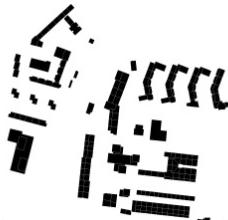
7 Lisbon: Predominant periods of construction Figure (up): Distribution of buildings by the predominant period of construction classes in the city of Lisbon (with all classes and for each class): 1991-present, , , , before 1919, no buildings. Source: Produced by the author (data from INE, 2011)

")
 Typology")


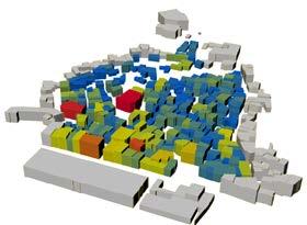
8 Methodology Dimension Analysis/Method Tools Output Statistical Data Spatial Data a) Morphological analysis b) Typology identification c) Urban form metrics analysis d) Correlation and cluster analysis Lisbon Case study ArcGIS SPSS Patch Analyst Urban form parameters CDA, DA, Env. Rad., Passive VR ArcGIS UMI Urban building information Operational Energy UD
 - Edge Density (ED) Quantifies the degree of complexity of the planar shapes Measures the number of edges of a certain shape -")
9 Urban Form Analysis: spatial metrics Dimension Spatial Representation Description Metrics Definition Complexity Measures the building s design characteristics individually and as a whole at the neighborhood scale - Mean Patch Fractal Dimension (MPFD) - Edge Density (ED) Quantifies the degree of complexity of the planar shapes Measures the number of edges of a certain shape - Surface-to-Volume Ratio (SVRatio) The ratio of the envelope of a building (external facades and roof) to the entire volume of that building (sqm.) Heterogeneity Diversity of buildings sizes - Patch Size Coefficient of Variation (PSCoV) The variance in a certain area of the sizes of the shapes. It is a good indicator of the heterogeneity of buildings sizes across a typology Compactness Measures if the neighborhood is fragmented (clustered) with no or limited connection between its parts, or if there is a connection between buildings, therefore having a more uniform design - Patch Density (PD) - Average Near Neighbor (ANN) A low patch density corresponds to highly dispersed areas, (low number of shapes per area), and a high shape density corresponds to more concentrated areas ( a high number of shapes per area) A low ANN ratio corresponds to areas which are highly fragmented, and a high ANN ratio correspond to more compact areas - Coverage Ratio (CR) The ratio of the sum of the building footprint areas to that of the sample area Density The vertical dimension of the neighborhood and the capacity to accommodate people, activities and transportation - Floor Area Ratio (FAR) - Average Height (AvHeight) Defined as the ratio of the sum of the areas of all building floors to that of the sample area The average of the heights of all buildings in the sample area (m) - Road Density (RD) Total road length dividing by total land area (m/sqm)

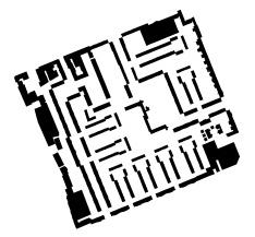
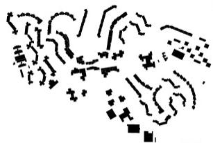
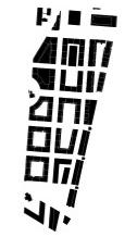
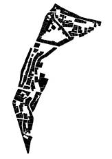
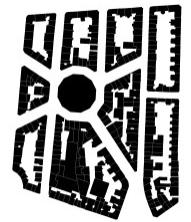
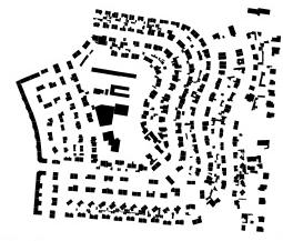
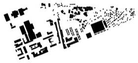
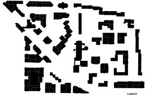
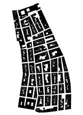
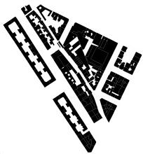
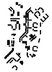
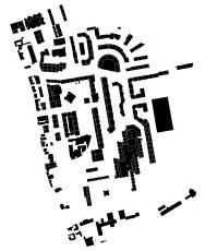
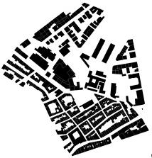
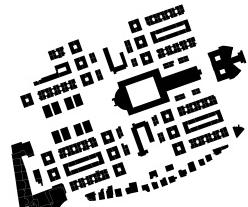
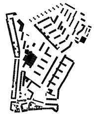
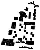
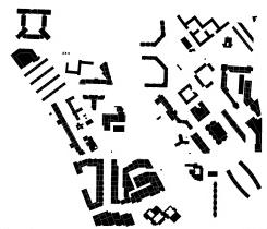
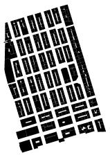
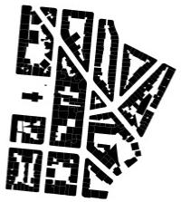
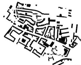
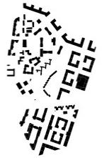
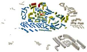
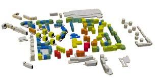
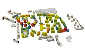
10 Urban Form Analysis: Typologies Typology/ Example (1) Before 1919 (2) (3) (4) (5) 1991-present (1) (2) (3) (4) (5)


 Complexity -- (5.")
 Compaction + (2.")
 Complexity ++ (1.")
 Compaction - (4.")
 Complexity - (4.")

 Compaction - (4.")
11 Urban Form Analysis: new arrangement of urban typologies based on cluster analysis Cluster Metric Configuration Height Volume CLUSTER 1 Complex Urban Areas CLUSTER 5 Heterogeneou s Urban Areas CLUSTER 2 ++ (1.00) Complexity -- (5.00) Heterogeneity + (1.67) Compaction + (2.33) Density - (3.33) Complexity ++ (1.00) Heterogeneity -- (4.67) Compaction - (4.00) Density + (2.00) Complexity - (4.00) Heterogeneity Elongated Urban Areas CLUSTER 3 Compact Urban Areas CLUSTER 4 Modern Urban Areas = (3.00) Compaction - (4.00) Density = (3.67) Complexity = (3.00) Heterogeneity ++ (1.33) Compaction ++ (2.00) Density -- (5.00) Complexity + (2.00) Heterogeneity - (4.33) Compaction = (2.67) Density
 Parts of buildings within 6 m of a façade present a significant reduction in energy consumption (almost 50%) compared with non-passive ones Envelope Radiation: the Envelope Radiation (ER)")
12 Urban Energy Analysis: Metrics Passive Volume Ratio: Ratti et al. (2004:772) Parts of buildings within 6 m of a façade present a significant reduction in energy consumption (almost 50%) compared with non-passive ones Envelope Radiation: the Envelope Radiation (ER) metrics assesses the accumulated solar radiation (MLux) for a given time frame, in this case for 1 year Daylight Autonomy: % of the floor area that exceeds 500 lux (value defined) for at least 50% of the time Continuous Daylight Autonomy: % of the floor area that exceeds 500 lux for at least 50% of the time giving a partial credit for time steps below 500 lux. Operational Energy: the amount of energy that is necessary for the building to run during 1 year. It takes into account the buildings specific characteristics, the shading of neighbor buildings and the blockage effect of contextual buildings.

 and Salat (2009) Climate file [epw.")
13 Operational Energy: UMI Template and climate file The template file aggregates for each building general information; buildings construction materials; thermal loads; HVAC setting and lighting and shading; Template that was edited based on reference U-Values for a building in Portugal, Lisbon, according to ADENE; All typologies were given the same values, thus allowing to understand the effect of urban geometry on energy consumption, according to Ratti (2004) and Salat (2009) Climate file [epw.] used was the one for Lisbon (Lisboa INETI)

")
 T5E2 T1E1 1.00 0.")

 Modern")
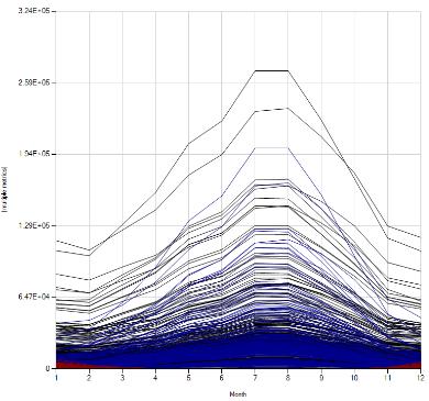
14 Results: Passive Volume Ratio Complex Urban Areas (T1E1) Elongated Urban Areas (T2E1) Compact Urban Areas (T2E5) T5E2 T1E T3E3 T2E5 T2E1 Heterogeneous Urban Areas (T3E3) Modern Urban Areas (T5E2)

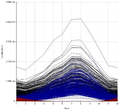
![area [m2]) Complex Urban](/docs-images/86/94882561/images/15-2.jpg "Areas (T1E1) Elongated")


15 Results: Envelope Radiation (Mlux/envelope area [m2]) Complex Urban Areas (T1E1) Elongated Urban Areas (T2E1) Compact Urban Areas (T2E5) T5E2 T1E T3E3 T2E5 T2E1 Heterogeneous Urban Areas (T3E3) Modern Urban Areas (T5E2)

 Elongated")


")
16 Urban Energy Analysis: Continuous Daylight Autonomy Complex Urban Areas (T1E1) Elongated Urban Areas (T2E1) Compact Urban Areas (T2E5) T5E2 T1E1 100% 80% 60% 40% 20% 0% T3E3 T2E5 T2E1 Heterogeneous Urban Areas (T3E3) Modern Urban Areas (T5E2)
17 Results: Operational Energy Operational Energy Breakdown (kwh/m2/year) T1E1 - Complex UA T3E3 - Heterogeneous UA T2E1 - Elongated UA T2E5 - Compact UA T5E2 - Modern UA Equipment (kwh/year/m2) Lighting (kwh/year/m2) Cooling (kwh/year/m2) Heating (kwh/year/m2) OE (m2) increases around 100% from the typology with the lowest consumption to the one with the highest
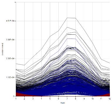

18 Results: Operational Energy (kwh/year) Total Cooling eating
19 Correlations between urban form and energy Urban Daylight Complexity Heter. Compaction Density Energy -Urban daylight metrics correlate mainly with themselves, also with operational energy -Urban complexity is positively correlated with operational energy -Heterogeneity is positively correlated with envelope radiation -Urban compaction is negatively correlated with urban daylight, particularly envelope radiation -Urban density is negatively correlated with daylight autonomy and passive volume Complete set of correlations. Bubble size is equivalent to the correlation strength. X-Axis correspondence: A) 1- CDA, 2- DA, 3- ER (m2), 4- ER (total), 5- Passive Volume Ratio; B) 6- MPFD, 7- ED, 8- SVRatio; C) 9- PSCOV; D) 10- PD, 11- ANN, 12- CR; E) 13- FAR, 14- AVHeight, 15- RD; F) 16- OE, 17- OE (m2) Source: Produced by the author -Operational energy (m2) correlates positively with envelope radiation, and to some degree, with passive volume ratio
20 Conclusions The following conclusions refer to the typologies presented and also to the specific climate of Portugal, Lisbon: Urban daylight access is critical for understanding energy demand; Typologies with a high passive volume ratio consume more energy; Typologies with very complex urban forms tend to consume more energy, this can also be related with urban daylight access; Typologies that have a more heterogeneous urban form, allow more solar exposure and therefore a higher envelope radiation; On the other hand, compact and dense typologies have lower levels of daylight access. This way, the typologies that performed better are the ones that have medium to low levels of complexity and heterogeneity and medium to high levels of compaction and density This is a complementary approach for analyzing urban form, being that a context analysis together with a historical and socio-economical anaylisis should always be made.

21 Thank You.
Urban Pattern Geometry and its Potential Energy Efficiency
 DOI: 10.14621/tna.20170104 Urban Pattern Geometry and its Potential Energy Efficiency Anna Yunitsyna* 1, Ernest Shtepani 2 1 Department of Architecture, Epoka University Tirana, Albania; ayunitsyna@epoka.edu.al
New Frameworks for Urban Sustainability Assessments: Linking Complexity, Information and Policy
 New Frameworks for Urban Sustainability Assessments: Linking Complexity, Information and Policy Moira L. Zellner 1, Thomas L. Theis 2 1 University of Illinois at Chicago, Urban Planning and Policy Program
Urban form, resource intensity & renewable energy potential of cities
 Urban form, resource intensity & renewable energy potential of cities Juan J. SARRALDE 1 ; David QUINN 2 ; Daniel WIESMANN 3 1 Department of Architecture, University of Cambridge, 1-5 Scroope Terrace,
Module 3 Indicator Land Consumption Rate to Population Growth Rate
 Regional Training Workshop on Human Settlement Indicators Module 3 Indicator 11.3.1 Land Consumption Rate to Population Growth Rate Dennis Mwaniki Global Urban Observatory, Research and Capacity Development
Application of GIS in urban planning. Iran Experiences of land use planning and air pollution
 Application of GIS in urban planning Iran Experiences of land use planning and air pollution Index Introducing the case study Geographical characteristics Demographical characteristics Urban Development
Vienna urban development - seestadt aspern as urban future lab
 Vienna urban development - seestadt aspern as urban future lab PERMACULTURE DESIGN COURSE * 2012 * ASPERN SEESTADT 1 Christof Schremmer, ÖIR Austrian Institute for Regional Studies and Spatial Planning
PAUL RUDOLPH Oriental Masonic Gardens
 1 PAUL RUDOLPH Oriental Masonic Gardens Latitude _ 41.3 N Longitude _ 72.9 W Climate: transition between Cfa _ Humid Subtropical and Dfa_ Humid Continental climate 2 Paul Rudolph INTRODUCTION Fig. 1 -
International Guidelines on Access to Basic Services for All
 International Guidelines on Access to Basic Services for All Presentation and initials lessons from implementation Accessibility to services in regions and cities : measures and policies, OECD 18 June
PREDICTING OVERHEATING RISK IN HOMES
 PREDICTING OVERHEATING RISK IN HOMES Susie Diamond Inkling Anastasia Mylona CIBSE Simulation for Health and Wellbeing 27th June 2016 - CIBSE About Inkling Building Physics Consultancy Susie Diamond Claire
The 3V Approach. Transforming the Urban Space through Transit Oriented Development. Gerald Ollivier Transport Cluster Leader World Bank Hub Singapore
 Transforming the Urban Space through Transit Oriented Development The 3V Approach Gerald Ollivier Transport Cluster Leader World Bank Hub Singapore MDTF on Sustainable Urbanization The China-World Bank
Urban White Paper on Tokyo Metropolis 2002
 Urban White Paper on Tokyo Metropolis 2002 By Bureau of City Planning Tokyo Metropolitan Government Part I. "Progress in IT and City Building" Effects of computer networks on cities and cities' response
Considerations of Urban Design and Microclimate in Historical Buildings Environment under Climate Change
 Considerations of Urban Design and Microclimate in Historical Buildings Environment under Climate Change Research team: Dr. Esther H.K. Yung, Mr. Z.N. Tan, Dr. C.K. Chau, Prof. Edwin, H.W. Chan Department
A Remote Sensing and GIS approach to trace the Densification in Residential Areas
 A Remote Sensing and GIS approach to trace the Densification in Residential Areas Valliappan AL Assistant Professor, School of Planning and Architecture, Vijayawada, India. Date:11/03/2015 What is Densification?
Tracey Farrigan Research Geographer USDA-Economic Research Service
 Rural Poverty Symposium Federal Reserve Bank of Atlanta December 2-3, 2013 Tracey Farrigan Research Geographer USDA-Economic Research Service Justification Increasing demand for sub-county analysis Policy
Spatial analysis of locational conflicts
 Spatial analysis of locational conflicts Case study: Locational conflicts generated by the expansion of built up surfaces in the northern area of Bucharest, Romania Diana A. ONOSE 1, Cristian I. IOJĂ 2,
2 nd Semester. Core Courses. C 2.1 City and Metropolitan Planning. Module 1: Urban Structure and Growth Implications
 2 nd Semester Core Courses C 2.1 City and Metropolitan Planning Module 1: Urban Structure and Growth Implications Growth of cities; cities as engine of growth; urban sprawl; land value, economic attributes
Rethinking Urbanization in the 21 st Century
 Rethinking Urbanization in the 21 st Century Karen C. Seto Professor of Geography & Urbanization Science School of Forestry & Environmental Studies Yale University SESYNC April 13, 2016 From now until
transportation research in policy making for addressing mobility problems, infrastructure and functionality issues in urban areas. This study explored
 ABSTRACT: Demand supply system are the three core clusters of transportation research in policy making for addressing mobility problems, infrastructure and functionality issues in urban areas. This study
Urban Process and Future Development of Colombo Metropolitan Area, Sri Lanka: An Application of Geospatial Techniques
 Urban Process and Future Development of Colombo Metropolitan Area, Sri Lanka: An Application of Geospatial Techniques January 2017 Suwandaralalage Indika Shyamantha SUBASINGHE Urban Process and Future
City definitions. Sara Ben Amer. PhD Student Climate Change and Sustainable Development Group Systems Analysis Division
 City definitions Sara Ben Amer PhD Student Climate Change and Sustainable Development Group Systems Analysis Division sbea@dtu.dk Contents 1. Concept of a city 2. Need for the city definition? 3. Challenges
Land Accounts - The Canadian Experience
 Land Accounts - The Canadian Experience Development of a Geospatial database to measure the effect of human activity on the environment Who is doing Land Accounts Statistics Canada (national) Component
Challenges around European cities
 Future Orientation for CIties (FOCI) Moritz Lennert IGEAT-ULB with ETC-LUSI, EUROREG, Géographie-Cités, IGUL, INRETS-LVMT, NTUA, TERSYN ESPON Seminar Malmö, 2 3 December2009 2/25 Challenges around European
3D-SDI contribution to energy-efficient cities 3D CityModels for Energy Demand Simulation
 HFT Research 3D-SDI contribution to energy-efficient cities 3D CityModels for Energy Demand Simulation Claudia Schulte, HFT Stuttgart, Institute for Applied Research Prof. Dr. Volker Coors, HFT Stuttgart,
Spatial profile of three South African cities
 Spatial Outcomes Workshop South African Reserve Bank Conference Centre Pretoria September 29-30, 2009 Spatial profile of three South African cities by Alain Bertaud September 29 Email: duatreb@msn.com
AFRICAN URBANIZATION: SOME KEY ISSUES. Patricia Jones University of Oxford IGC Conference, Dar es Salaam 25 th February 2015
 AFRICAN URBANIZATION: SOME KEY ISSUES Patricia Jones University of Oxford IGC Conference, Dar es Salaam 25 th February 2015 Introduction New project on urbanization in Africa. World Bank funded but independent
CHARACTERIZATION OF SOLAR ACCESS IN MEDITERRANEAN CITIES: ORIENTED SKY FACTOR
 CHARACTERIZATION OF SOLAR ACCESS IN MEDITERRANEAN CITIES: ORIENTED SKY FACTOR Garcia-Nevado, Elena School of Architecture of Barcelona elena.garcia.nevado@upc.edu Pagès-Ramon, Anna School of Architecture
What is a compact city? How could it be measured?
 What is a compact city? How could it be measured? Madhu Singh Transport Planner Directorate of Urban Land Transport, Bangalore Guided By: Professor H. M. Shivanand Swamy CEPT University, Ahmedabad Cities
Assessing the benefit of green infrastructure/wsud on urban microclimate
 Supporting the strategic planning of City of Unley (SA) towards a water sensitive city by quantifying the urban microclimate benefits using the Water Sensitive Cities Modelling Toolkit A Collaboration
Urban Planning for Climate Change
 Urban Planning for Climate Change FIG Working Group 8.1 Frank Friesecke, Sophie Schetke, Theo Kötter AGENDA 1. Introduction 2. Urbanisation and Climate Change 3. Need of the Surveying Profession in Dealing
ANALYSING THE DIVERSITY OF DEPRIVED AREAS IN MUMBAI, INDIA
 ANALYSING THE DIVERSITY OF DEPRIVED AREAS IN MUMBAI, INDIA MONIKA KUFFER (M.KUFFER@UTWENTE.NL) KARIN PFEFFER, RICHARD SLIUZAS, ISA BAUD, MARTIN VAN MAARSEVEEN Source: Google Earth CONTENT OF PRESENTATION
URBAN PATTERN ANALYSIS -MAJOR CITIES IN INDIA.
 URBA PATTER AALYSIS -MAJOR CITIES I IDIA. Sowmyashree. M.V 1,3, T.V. Ramachandra 1,2,3. 1 Centre for Ecological Science. 2 Centre for Sustainable Technology. 3 Centre for infrastructure, Sustainable Transportation
GEOENGINE - MSc in Geomatics Engineering
 Master Thesis Neda Mohammadi Naghadeh Large-scale characterization of human settlement patterns using binary settlement masks derived from globally available TerraSAR-X data Duration of the Thesis: 6 months
Improving rural statistics. Defining rural territories and key indicators of rural development
 Improving rural statistics Defining rural territories and key indicators of rural development Improving rural statistics Improving Rural Statistics In 2016, the Global Strategy to improve Agricultural
P. O. Box 5043, 2600 CR Delft, the Netherlands, Building, Pokfulam Road, Hong Kong,
 THE THEORY OF THE NATURAL URBAN TRANSFORMATION PROCESS: THE RELATIONSHIP BETWEEN STREET NETWORK CONFIGURATION, DENSITY AND DEGREE OF FUNCTION MIXTURE OF BUILT ENVIRONMENTS Akkelies van Nes 1, Yu Ye 2 1
Solar Radiation Protections on Façades: A Case Study in a Hot Semi-Humid Climate
 Solar Radiation Protections on Façades: A Case Study in a Hot Semi-Humid Climate ADRIANA LIRA-OLIVER 1, JORGE ROJAS 2, GUADALUPE HUELSZ 2, GUILLERMO BARRIOS 2, FRANCISCO ROJAS 2 1 3S-Consulting for Sustainable
INSTITUTE OF TOWN PLANNERS, INDIA TOWN PLANNING EXAMINATION BOARD ASSOCIATESHIP EXAMINATION
 SUBJECT: C.1.1. Planning Theory Maximum Marks: 20 1. What is Rational Planning Model? Discuss its main features. 2. Discuss the salient features of Advocacy Planning Theory. 3. Discuss David Harvey s contribution
Morphology, Sustainable Evolution of Inner-urban Neighborhoods in San Francisco
 Morphology, Sustainable Evolution of Inner-urban Neighborhoods in San Francisco Associate Professor, Department of Environmental Engineering and Architecture, Graduate School of Environmental Studies University
ACCESSIBILITY TO SERVICES IN REGIONS AND CITIES: MEASURES AND POLICIES NOTE FOR THE WPTI WORKSHOP, 18 JUNE 2013
 ACCESSIBILITY TO SERVICES IN REGIONS AND CITIES: MEASURES AND POLICIES NOTE FOR THE WPTI WORKSHOP, 18 JUNE 2013 1. Significant differences in the access to basic and advanced services, such as transport,
AP Human Geography Syllabus
 AP Human Geography Syllabus Textbook The Cultural Landscape: An Introduction to Human Geography. Rubenstein, James M. 10 th Edition. Upper Saddle River, N.J.: Prentice Hall 2010 Course Objectives This
Spatial Variability of Aerosol - Cloud Interactions over Indo - Gangetic Basin (IGB)
") Spatial Variability of Aerosol - Cloud Interactions over Indo - Gangetic Basin (IGB) Shani Tiwari Graduate School of Environmental Studies Nagoya University, Nagoya, Japan Email: pshanitiwari@gmail.com
Spatial Variability of Aerosol - Cloud Interactions over Indo - Gangetic Basin (IGB) Shani Tiwari Graduate School of Environmental Studies Nagoya University, Nagoya, Japan Email: pshanitiwari@gmail.com
"Natural" Cultural Districts and Neighborhood Revitalization
 University of Pennsylvania ScholarlyCommons Culture and Community Revitalization: A Collaboration Social Impact of the Arts Project 6-2009 "Natural" Cultural Districts and Neighborhood Revitalization Mark
Geographical Information Systems Energy Database Report. WP1 T1.3- Deliverable 1.9
 Geographical Information Systems Energy Database Report WP1 T1.3- Deliverable 1.9 March 2015 1 314164 (ENER/FP7/314164) Project acronym: InSMART Project full title: Integrative Smart City Planning Coordination
COOL CONSTRUCTION MATERIALS
 2010 COOL CONSTRUCTION MATERIALS PAPER 11 PRESENTATION OF SUCCESS STORIES ABOLIN CO. OCTOBER 2010 Introduction There are three main ways to stop global warming and climate change from getting worse and
A Joint Tour-Based Model of Vehicle Type Choice and Tour Length
 A Joint Tour-Based Model of Vehicle Type Choice and Tour Length Ram M. Pendyala School of Sustainable Engineering & the Built Environment Arizona State University Tempe, AZ Northwestern University, Evanston,
CityBES: A Data and Computing Platform for City Buildings
 CityBES: A Data and Computing Platform for City Buildings Yixing Chen, Tianzhen Hong, Mary Ann Piette, Xuan Luo Building Technology and Urban Systems Division Urban Infrastructures NSF Workshop New York
THE USE OF SPATIAL IMAGES IN THE PROJECTS OF URBAN DEVELOPMENT FOR BUCHAREST
 VASILE LOGHIN 290 THE USE OF SPATIAL IMAGES IN THE PROJECTS OF URBAN DEVELOPMENT FOR BUCHAREST Key words: Spatial image, city of Bucharest, urban development project, geospatial analysis Abstract: In Romania,
Exploring Reciprocal Relationships of Land-Uses in a Historical Mixed-Use Quarter of Istanbul
 Exploring Reciprocal Relationships of Land-Uses in a Historical Mixed-Use Quarter of Istanbul Measuring mixed-use patterns of Cihangir Ahu Sokmenoglu 1, N. Onur Sonmez 2 Istanbul Technical University,
EXPLORING THE FUTURE WATER INFRASTRUCTURE OF CITIES
 EXPLORING THE FUTURE WATER INFRASTRUCTURE OF CITIES Eng. Arlex Sanchez Torres PhD. R.K. Price PhD. Z. Vojinovic Jan 24 th - 2011 The future of urban water: Solutions for livable and resilient cities SWITCH
PV 2012/2013. Radiation from the Sun Atmospheric effects Insolation maps Tracking the Sun PV in urban environment
 SOLAR RESOURCE Radiation from the Sun Atmospheric effects Insolation maps Tracking the Sun PV in urban environment 1 is immense Human energy use: 4.0x10 14 kwh/year on Earth s surface: 5.5x10 17 kwh/year
AP Human Geography. Additional materials, including case studies, videos, and aerial photos, will be used to supplement primary course materials.
 Course Introduction AP Human Geography is a yearlong college-level course designed to prepare students for the Advanced Placement (AP) Human Geography Exam. The course focuses on the study of human populations
Building Energy Demand under Urban Climate and Climate Change conditions with consideration of Urban Morphology and Building Typology
 Building Energy Demand under Urban Climate and Climate Change conditions with consideration of Urban Morphology and Building Typology - GIS Mapping of the City of Stuttgart Limei Ji Fazia Ali-Toudert 1,
Urban land cover and land use extraction from Very High Resolution remote sensing imagery
 Urban land cover and land use extraction from Very High Resolution remote sensing imagery Mengmeng Li* 1, Alfred Stein 1, Wietske Bijker 1, Kirsten M.de Beurs 2 1 Faculty of Geo-Information Science and
Developing a Resourcebased Typology of Cities: A review + pitch
 Developing a Resourcebased Typology of Cities: A review + pitch Prof. John Fernández Urban Metabolism Group 19 November 2013 Sustainable Cities RCN MIT Agenda Typologies Motivations Past work History/trends
Urban Spatial Scenario Design Modelling (USSDM) in Dar es Salaam: Background Information
 in Dar es Salaam: Background Information") Urban Spatial Scenario Design Modelling (USSDM) in Dar es Salaam: Background Information Modelling urban settlement dynamics in Dar es Salaam Revision: 2 (July 2013) Prepared by: Katja Buchta TUM team
Urban Spatial Scenario Design Modelling (USSDM) in Dar es Salaam: Background Information Modelling urban settlement dynamics in Dar es Salaam Revision: 2 (July 2013) Prepared by: Katja Buchta TUM team
Cities in Bad Shape: Urban Geometry in India
 Cities in Bad Shape: Urban Geometry in India Mariaflavia Harari MIT IGC Cities Research Group Conference 21 May 2015 Introduction Why Study City Shape A wide range of factors determine intra-urban commuting
LISBON Fragments of a complex City
 LISBON Fragments of a complex City Jorge Rocha Jorge.rocha@campus.ul.pt Catarina Rodrigo Daniel Campeão Luis Encalada Maurício Santos Pedro Dias From the technical point of view, the Smart City model considers
Smart City Governance for effective urban governance. David Ludlow Assoc. Professor European Smart Cities University of the West of England, Bristol
 Smart City Governance for effective urban governance David Ludlow Assoc. Professor European Smart Cities University of the West of England, Bristol Complexities of urban territorial governance Complexities
Luminous Data Analysis and Quality Assurance of Climate Based Daylighting Simulation. Francesco Anselmo
 Luminous Data Analysis and Quality Assurance of Climate Based Daylighting Simulation Francesco Anselmo 2 Windows 3 Recent window design Le Corbusier A sheet of glass and three partition walls make an ideal
Tackling urban sprawl: towards a compact model of cities? David Ludlow University of the West of England (UWE) 19 June 2014
 19 June 2014") Tackling urban sprawl: towards a compact model of cities? David Ludlow University of the West of England (UWE) 19 June 2014 Impacts on Natural & Protected Areas why sprawl matters? Sprawl creates environmental,
Tackling urban sprawl: towards a compact model of cities? David Ludlow University of the West of England (UWE) 19 June 2014 Impacts on Natural & Protected Areas why sprawl matters? Sprawl creates environmental,
Measuring and Monitoring SDGs in Portugal: Ratio of land consumption rate to population growth rate Mountain Green Cover Index
 Measuring and Monitoring SDGs in Portugal: 11.3.1Ratio of land consumption rate to population growth rate 15.4.2 Mountain Green Cover Index United Nations World Geospatial Information Congress João David
Literature revision Agent-based models
 Literature revision Agent-based models Report 12 Universitat Politècnica de Catalunya Centre de Política de Sòl i Valoracions Literature revision Agent-based models Eduardo Chica Mejía Personal de recerca
BUILDING SOUND AND COMPARABLE METRICS FOR SDGS: THE CONTRIBUTION OF THE OECD DATA AND TOOLS FOR CITIES AND REGIONS
 BUILDING SOUND AND COMPARABLE METRICS FOR SDGS: THE CONTRIBUTION OF THE OECD DATA AND TOOLS FOR CITIES AND REGIONS STATISTICAL CAPACITY BUILDING FOR MONITORING OF SUSTAINABLE DEVELOPMENT GOALS Lukas Kleine-Rueschkamp
Subject: Note on spatial issues in Urban South Africa From: Alain Bertaud Date: Oct 7, A. Spatial issues
 Page 1 of 6 Subject: Note on spatial issues in Urban South Africa From: Alain Bertaud Date: Oct 7, 2009 A. Spatial issues 1. Spatial issues and the South African economy Spatial concentration of economic
ARCHITECTURE IN THE DAYLIGHT
 ARCHITECTURE IN THE DAYLIGHT Site Location MANUS LEUNG HARVARD GSD FALL 2015 The house is located in Jl. Intern Corn Kebun Jeruk Blok U3 No.18, Kembangan District of Jakarta 11640 Indonesia. 01 OBJECTIVES
I N C L U S I V E & S U S T A I N A B L E H O U S I N G I N C A P E T O W N
 I N C L U S I V E & S U S T A I N A B L E H O U S I N G I N C A P E T O W N Inclusive & Sustainable Housing in Cape Town Prepared by: Amy Koshy With the help of: Tommaso Bitossi Matthias Rammig C O N T
Experimental Performance and Numerical Simulation of Double Glass Wall Thana Ananacha
 Experimental Performance and Numerical Simulation of Double Glass Wall Thana Ananacha Abstract This paper reports the numerical and experimental performances of Double Glass Wall are investigated. Two
The impact of urban geometry on the radiant environment in outdoor spaces
 ICUC9 9 th International Conference on Urban Climate 20 th -24 th July 2015, Toulouse, France The impact of urban geometry on the radiant environment in outdoor spaces Christina Chatzipoulka*, Marialena
Simulating Mobility in Cities: A System Dynamics Approach to Explore Feedback Structures in Transportation Modelling
 Simulating Mobility in Cities: A System Dynamics Approach to Explore Feedback Structures in Transportation Modelling Dipl.-Ing. Alexander Moser [amoser@student.tugraz.at] IVT Tagung 2013 - Kloster Kappel
Dr. Orit Rotem-Mindali Department of geography and environment, Bar Ilan University, ISRAEL. Barcelona, ERSA Conference, 2011
 Retail fragmentation vs. urban livability: Applying ecological methods in urban geography Dr. Orit Rotem-Mindali Department of geography and environment, Bar Ilan University, ISRAEL Barcelona, ERSA Conference,
City of Jerez Urban Core Densification proposal; An Agent Based Spatio-temporal model
 Modelling urban population allocation City of Jerez Urban Core Densification proposal; An Agent Based Spatio-temporal model Elke Sauter Julia Úbeda Who we are & why we are here Masters programme: Geographical
Intra-metropolitan polycentricity in practice
 Intra-metropolitan polycentricity in practice Results from our questionnaire survey - 11 metropolitan areas Naples, Mazovia, Frankfurt/Rhein-Main, Veneto, Paris, Rotterdam, Helsinki, Emilia-Romagna, Tri-City,
Spatial metrics for Greek cities using land cover information from the Urban Atlas
 Spatial metrics for Greek cities using land cover information from the Urban Atlas Poulicos Prastacos IACM-FORTH P.O. Box 1385 Heraklion, Greece poulicos@iacm.forth.gr Nektarios Chrysoulakis IACM-FORTH
Most people used to live like this
 Urbanization Most people used to live like this Increasingly people live like this. For the first time in history, there are now more urban residents than rural residents. Land Cover & Land Use Land cover
Geospatial Analysis of Job-Housing Mismatch Using ArcGIS and Python
 Geospatial Analysis of Job-Housing Mismatch Using ArcGIS and Python 2016 ESRI User Conference June 29, 2016 San Diego, CA Jung Seo, Frank Wen, Simon Choi and Tom Vo, Research & Analysis Southern California
A Review of Concept of Peri-urban Area & Its Identification
 A Review of Concept of Peri-urban Area & Its Identification Ar. Manita Saxena Research Scholar Department of Architecture and Planning M.A.N.I.T, Bhopal Dr. Supriya Vyas Assistant Professor, Department
PRIMA. Planning for Retailing in Metropolitan Areas
 PRIMA Planning for Retailing in Metropolitan Areas Metropolitan Dimension to sustainable retailing futures Metropolitan strategies Retailing in city and town centres will be a primary component of any
Key Issue 1: Where Are Services Distributed?
 Key Issue 1: Where Are Services Distributed? Pages 430-433 *See the Introduction on page 430 to answer questions #1-4 1. Define service: 2. What sector of the economy do services fall under? 3. Define
How GIS based Visualizations Support Land Use and Transportation Modeling
 How GIS based Visualizations Support Land Use and Transportation Modeling ESRI International Users Conference San Diego, CA - July 23, 2015 Prepared by: Troy Hightower Introduction This presentation will
How the science of cities can help European policy makers: new analysis and perspectives
 How the science of cities can help European policy makers: new analysis and perspectives By Lewis Dijkstra, PhD Deputy Head of the Economic Analysis Unit, DG Regional and European Commission Overview Data
São Paulo Metropolis and Macrometropolis - territories and dynamics of a recent urban transition
 São Paulo Metropolis and Macrometropolis - territories and dynamics of a recent urban transition Faculty of Architecture and Urbanism of São Paulo University Prof. Dr. Regina M. Prosperi Meyer WC2 - World
The Analysis of Economic Development and Resilience Dynamics of Medium-Sized Towns
 Master Thesis Student: Ksenija Banovac Thesis supervisor: prof. Abdelillah Hamdouch, University François Rabelais, Tours The Analysis of Economic Development and Resilience Dynamics of Medium-Sized Towns
Atmospheric Composition and Structure
 Atmospheric Composition and Structure Weather and Climate What is weather? The state of the atmosphere at a specific time and place. Defined by: Humidity, temperature, wind speed, clouds, precipitation,
Spatio-temporal dynamics of the urban fringe landscapes
 Spatio-temporal dynamics of the urban fringe landscapes Yulia Grinblat 1, 2 1 The Porter School of Environmental Studies, Tel Aviv University 2 Department of Geography and Human Environment, Tel Aviv University
Land Use Modelling for Environmental and Ecological Policy Assessment:
 Judith Borsboom Land Use Modelling for Environmental and Ecological Policy Assessment: Sustainable Netherlands Study in collaboration with: Wageningen University & Research centre WL Delft Hydraulics Arcadis
Analysis of urban sprawl phenomenon
 Analysis of urban sprawl phenomenon Detection of city growth based on spatiotemporal analysis and landscape metrics. Leopold Leśko University for Sustainable Development Eberswalde, 2013 Presentanion Outline
Urbanization and Sustainable Development of Cities: A Ready Engine to Promote Economic Growth and Cooperation
 Urbanization and Sustainable Development of Cities: A Ready Engine to Promote Economic Growth and Cooperation Wan Portia Hamzah Institute of Strategic and International Studies (ISIS) Malaysia 10 September
PLUTO The Transport Response to the National Planning Framework. Dr. Aoife O Grady Department of Transport, Tourism and Sport
 PLUTO 2040 The Transport Response to the National Planning Framework Dr. Aoife O Grady Department of Transport, Tourism and Sport Dublin Economics Workshop 15 th September 2018 The Story of Pluto National
Labour MarketAreas: ThePortuguese case
 «Labour MarketAreas: ThePortuguese case Elsa Soares Rossano Figueiredo Unit for the Coordination of Territorial Statistics Lisboa, 30 June 2016 « Overview 1 THE IMPORTANCE OF DEFINING FUNCTIONAL REGIONS
Individual Self-help Housing Reconstruction with Relocation: Transformation of Built Environment after the Great East Japan Earthquake
 Individual Self-help Housing Reconstruction with Relocation: Transformation of Built Environment after the Great East Japan Earthquake Tamiyo Kondo, Kobe University tamiyok@people.kobe-u.ac.jp Yuka Karatani,
Vincent Goodstadt. Head of European Affairs METREX European Network
 Vincent Goodstadt Head of European Affairs METREX European Network METREX (Network of 50 European Metropolitan Regions and Areas ) Exchanging Knowledge (e.g. Benchmarking) Climate Change CO2/80/50 Expertise
The Role of Urban Planning and Local SDI Development in a Spatially Enabled Government. Faisal Qureishi
 The Role of Urban Planning and Local SDI Development in a Spatially Enabled Government Faisal Qureishi 1 Introduction A continuous increase in world population combined with limited resources has lead
Spatial Analysis and Modeling of Urban Land Use Changes in Lusaka, Zambia: A Case Study of a Rapidly Urbanizing Sub- Saharan African City
 Spatial Analysis and Modeling of Urban Land Use Changes in Lusaka, Zambia: A Case Study of a Rapidly Urbanizing Sub- Saharan African City January 2018 Matamyo SIMWANDA Spatial Analysis and Modeling of
Solar radiation and architectural design in Barcelona
 Solar radiation and architectural design in Barcelona Reconciling protection in summer and gain in winter Alexis AGUILAR 1 Carlos ALONSO 1 Helena COCH 1 Rafael SERRA 1 1 ABSTRACT: The principles of the
INSPIRE and CityGML Energy ADE An example from CitiEnGov project
 Delft (NL) 6 th December 2018 INSPIRE and CityGML Energy ADE An example from CitiEnGov project CitiEnGov Dedagroup Public Services Piergiorgio Cipriano WHO I AM AND WHY I AM HERE TAKING COOPERATION FORWARD
Towards a cellular automata based land-use transportation model
 Towards a cellular automata based land-use transportation model Nuno Norte Pinto * Department of Civil Engineering, University of Coimbra, Coimbra, Portugal António Pais Antunes Department of Civil Engineering,
Thoughts toward autonomous land development. Introduction
 Thoughts toward autonomous land development Spatial Transformation of Regular grid Irrigation Frameworks Bangkok and Cairo A Work in Progress Information based on student workshop June 2009 and earlier
GENIUS: A tool for classifying and modelling evolution of urban typologies
 GENIUS: A tool for classifying and modelling evolution of urban typologies Marion BONHOMME 1, Hassan AIT HADDOU 2, Luc ADOLPHE 3 1 LRA, Ecole Nationale d Architecture de Toulouse, France 2 Ecole Nationale
TERRITORIAL IMPACT ASSESSMENT: AN APPROACH TO IMPROVE THE VERTICAL AND HORIZONTAL INTEGRATION OF EU POLICIES
 TERRITORIAL IMPACT ASSESSMENT: AN APPROACH TO IMPROVE THE VERTICAL AND HORIZONTAL INTEGRATION OF EU POLICIES Naja Marot & Mojca Golobič Biotehnical Faculty, University of Ljubljana, Slovenia RSA Workshop
Application of Geographic Information Systems for Government School Sites Selection
 Rs. 3000,00 Application of Geographic Information Systems for Government School Sites Selection by K. D. Nethsiri Jayaweera M.Sc. Library - USJP 1111111111111111 210975 2014 210873 Application of Geographic
Economic consequences of floods: impacts in urban areas
 Economic consequences of floods: impacts in urban areas SWITCH Paris Conference Paris, 24 th 26 th January 2011 Economic consequences of floods: impacts in urban areas Institutions: Authors Vanessa Cançado