LISBON Fragments of a complex City
|
|
|
- Patrick Nash
- 6 years ago
- Views:
Transcription

1 LISBON Fragments of a complex City Jorge Rocha Jorge.rocha@campus.ul.pt Catarina Rodrigo Daniel Campeão Luis Encalada Maurício Santos Pedro Dias
2 From the technical point of view, the Smart City model considers the city as a complex system made up of citizens, resources and services. The status of each service is monitored through a layer of sensors, which send the captured data through the appropriate communication network to an analysis platform. According to the late scientist John Henry Holland, complex adaptive systems are characterized by the presence of components that learn through interaction. This is a useful metaphor for the potential of smart city systems. In smart cities, order is needed for planners to channel technological capabilities productively, while chaos provides a dynamic and flexible space for business and social innovation to breathe. The sterile and the organic exist in paradoxical equilibrium.
3 We have intuitively invented the best way to create vast social networks embedded in space and time, and keep them growing and evolving without having to stop. When that is possible, a social species can sustain ways of being incredibly inventive and productive. Smart Cities moved then into the mainstream as governments (including the European Union) commit sizeable funding and policy to smart city development, through deployments of smart city protocols and operating platforms and acceptance of smart technologies as the norm in transport, energy, development, assisted living and security. The purpose of the smart cities passes through ensure prosperity, competitiveness, efficiency and sustainability in various socio-economic levels. The city of Lisbon, the strategic sectors are defined by the City Council (LCC) and are the creative economy, the sea economy, health, commerce, tourism and ICT. In a close connection to strategic sectors, it is important to establish a Map of Knowledge and Innovation (MKI), which identifies the institutional actors related to knowledge, research, innovation and creativity.
4 Pedro Dias MSc. GIS Smart Cities are designed as a function of a immaterial vision (Dameri and Rosenthal-Sabroux, 2014). It is important to note, that as larger the cultural capital present in a city, more efficient are the decisions taken.

5 The use of collective human and intellectual capital from a strategic point of view is another of the key elements that should not be overlooked.
6

7 BIG DATA & SOCIAL MEDIA Luis Encalada MSc. GIS Photos from Panoramio Better positional accuracy of photos dataset (Zielstra and Hochmair, 2013). Panoramio requieres geotagging information during the upload process, photos are reviewed in order to be accepted for been published in Google maps. Understanding popularity in Panoramio When you explore the world by using Panoramio's map or Google Earth, you want to see the best photos of a place first! That's why the most popular photos are visible at higher zoom levels. You'll see the other photos as you zoom into a location, with the least popular photos appearing only at the lowest zoom levels.

8 Retrieving data from Panoramio Summary of retrieved photos Photos Grid Resolution(m) Retrieved Repeated Unique New Accumulated % 5,000 14, , , ,500 14, ,036 2,826 16, ,000 17, ,333 3,267 20, ,500 20, ,788 3,688 23, ,000 24, ,359 3,762 27, ,800 24, ,560 1,953 29, ,600 28, ,872 2,726 32, ,400 29, ,370 2,529 34, ,200 36, ,625 6,270 40, ,000 38, ,496 4,322 45, ,800 38, ,645 1,614 46, ,600 38, ,789 1,846 48, ,400 41, ,757 1,574 50, ,200 48, ,935 2,867 53, ,000 49,048 5,996 43,052 4,535 57, , ,117 2,047 59, , ,451 2,076 61, , ,548 2,101 63, , ,609 1,464 65, ,229 6,773 48,456 1,014 66, ,824 1,043 62,781 2,628 69, ,151 8,627 57,524 6,054 75,


9 LISBON: Fragments of a complex City Geotagged photos dataset

, calculate the difference")

; Kádár (2014) also used this")
10 LISBON: Fragments of a complex City Geotagged photos dataset from Visitors Girardin et al. (2008), calculate the difference between the time-stamps of the users first and last images taken in the area. García-Palomares et al. (2015); Kádár (2014) also used this approach to differentiate the photos.

11 Geotagged photos dataset (Locals vs. Visitors)


12 LISBON: Fragments of a complex City Data aggregation by regular grid Area 2,165 m2 Side 29 m

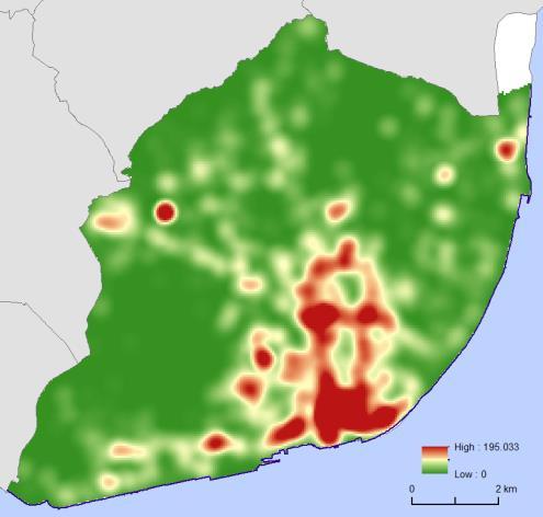
13 Hot spot analysis (Spatial)
 Comparing the")

14 Photos by months Spatiotemporal data visualization Survey apply to tourists about their activities in Lisbon (Source: Inquérito às actividades dos turistas, 2014) Comparing the data retrieved from Panomario with data from surveys: The six most visited places in Lisbon according to the survey, also present high number of photos (taken by visitors throughout the year).


15 Intensifying Hot Spot: The intensity of clustering of high counts in each time step is increasing overall. Persistent Hot Spot: A statistically significant hot spot with no discernible trend indicating an increase or decrease in the intensity of clustering over time. Diminishing Hot Spot: The intensity of clustering in each time step is decreasing overall. Sporadic Hot Spot: A location that is an on-again then off-again hot spot. Consecutive Hot Spot: A statistically significant hot spot in the final time-step intervals. Hot spot analysis Spatiotemporal
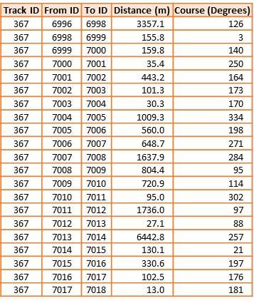
16 Path attributes
17 Restauration Vs. Tourists

18 Green Areas Vs. Tourists
 Green Areas Shrubs were considered as a potential place to hide")
19 SUSTAINABILITY? # Rapes (2015) Green Areas Shrubs were considered as a potential place to hide for perpetrators or obstructions of view (Lindgren and Nilsen, 2012).

20 Crime and fear of crime in urban green spaces were also recognized as potentially important influences on mental health and wellbeing (Lorenc et al., 2012; Foster et al., 2013).


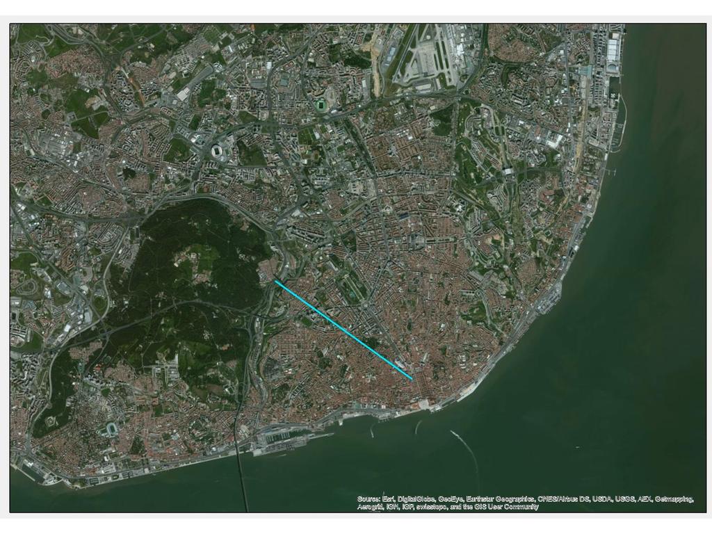
21 URBAN WELLBEING Daniel Campeão Maurício Santos MSc. GIS Street connectivity means the level of connection in streets reflected to the human activities (Marshall and Garrick, 2010). In street connectivity, visibility is one of the factors that reveal the connection between pedestrian and street environment.


22 LISBON: Fragments of a complex City The highest connectivity is This means that the point is viewed from locations in the street network. Thus, the red area is most viewed area which connected from various locations and this reflects pedestrian movement in identifying the streets. The graph also shows privacy of the streets. The low connectivity area (5) means the less viewed area.


.")

23 The use of energy from renewable sources is an importante objective of the European Union energy policy (Mabee, 2013). Among many available sources of renewable energy, solar energy is clearly a promising option and its market has seen outstanding growth in recent years (Devabhaktuni et al., 2013). Catarina Rodrigo MSc. GIS A - Alta de Lisboa C - Parque das Nações B - Baixa D - Madre Deus A B C D


24 Public spaces, including transport infrastructure, could be contributing to the power generation of the future, with solar energy capture systems built into common outdoor surfaces including highway barriers, seating, pedestrian paving, cycle paths and even road surfaces. Smartphones may be getting smarter, but their batteries are draining faster, and so people are looking for reliable public places to recharge electronic devices.
25 General parameters Model Resolution- Establishes the sky size for all possible model outputs. 1 - SKY SIZE Test area: Alta de Lisboa grid (1201 rows X 1201 columns); Max. resolution: 8 hours (7h58m02seg) Min. resolution: 13 minutes Average processing time: 0.02 seg. per pixel


26 General parameters Model Resolution Alta de Lisboa Baixa Madre Deus Parque das Nações
 Processing time 360 7h 58m 02 seg. 256 7h 38m 10 seg. 32 7h 25m 47 seg. 16 7h 21m 37 seg.")
27 General parameters Model Resolution CALCULATION DIRECTIONS Sky Size resolution 4000 X X X X 4000 CALC. DIRECTI ONS( 0 ) Processing time 360 7h 58m 02 seg h 38m 10 seg. 32 7h 25m 47 seg. 16 7h 21m 37 seg. 16 DIRECTIONS 32 DIRECTIONS 256 DIRECTIONS 360 DIRECTIONS


28 Topographic configuration Slopes and Aspect LISBON: Fragments of a complex City FROM DEM FLAT SURFACE


29 Solar potential quantification for different ground levels LISBON: Fragments of a complex City Madre Deus Alta de Lisboa Baixa Parque das Nações 0m 1m 5m 10m


30 Shadow variation LISBON: Fragments of a complex City Madre Deus Alta de Lisboa Baixa Parque das Nações


31 17:00 h 12:30 h 08:00 h LISBON: Fragments of a complex City 0 m 5 m 10 m % shaded area at different times of the day and different ground levels Inverno Verão Inverno Verão $ Base Sombra
Land Use in the context of sustainable, smart and inclusive growth
 Land Use in the context of sustainable, smart and inclusive growth François Salgé Ministry of sustainable development France facilitator EUROGI vice president AFIGéO board member 1 Introduction e-content+
16540/14 EE/cm 1 DG E 1A
 Council of the European Union Brussels, 5 December 2014 (OR. en) 16540/14 ENV 965 CULT 139 NOTE From: To: Subject: General Secretariat of the Council Delegations Charter of Rome on Natural and Cultural
Designing smart & Resilient cities:
 Designing smart & Resilient cities: How can Egyptian cities learn from an emerging global practice On the Cuspof Change Professor Samer Bagaeen FRICS MRTPI FRSA AoU 1. GLOBAL CHALLENGES POPULATION GROWTH,
Content Area: Social Studies Standard: 1. History Prepared Graduates: Develop an understanding of how people view, construct, and interpret history
 Standard: 1. History Develop an understanding of how people view, construct, and interpret history 1. Organize and sequence events to understand the concepts of chronology and cause and effect in the history
Low Density Areas : Places of Opportunity. Enrique Garcilazo, OECD Directorate for Public Governance and Territorial Development
 Low Density Areas : Places of Opportunity Enrique Garcilazo, OECD Directorate for Public Governance and Territorial Development Open Days, Brussels, 11 th October, 2016 Outline 1. Performance low density
GLOBAL SMART SUSTAINABLE CITY INDEX (SSC INDEX) FIRST DRAFT
 FIRST DRAFT") GLOBAL SMART SUSTAINABLE CITY INDEX (SSC INDEX) FIRST DRAFT THE GLOBAL CITY RANKING PRESENTED BY: BARBARA KOLM MALAGA, 26 APRIL 2018 PREPARATION OF THE SSC INDEX FIRST DRAFT This SSC INDEX is being developed
GLOBAL SMART SUSTAINABLE CITY INDEX (SSC INDEX) FIRST DRAFT THE GLOBAL CITY RANKING PRESENTED BY: BARBARA KOLM MALAGA, 26 APRIL 2018 PREPARATION OF THE SSC INDEX FIRST DRAFT This SSC INDEX is being developed
Towards a City Model for Heritage-Led Regeneration and Tourism Development
 Towards a City Model for Heritage-Led Regeneration and Tourism Development Brian Smith, Secretary General European Association of Historic Towns and Regions Summary of Presentation Objective Background
Assessing pervasive user-generated content to describe tourist dynamics
 Assessing pervasive user-generated content to describe tourist dynamics Fabien Girardin, Josep Blat Universitat Pompeu Fabra, Barcelona, Spain {Fabien.Girardin, Josep.Blat}@upf.edu Abstract. In recent
AMS E-GOS Local governance and performance of open data policies at municipal level
 AMS E-GOS Local governance and performance of open data policies at municipal level Frederika Welle Donker Knowledge Centre Open Data TU Delft f.m.welledonker@tudelft.nl 1 Knowledge Centre Open Data Research
Estimating Large Scale Population Movement ML Dublin Meetup
 Deutsche Bank COO Chief Data Office Estimating Large Scale Population Movement ML Dublin Meetup John Doyle PhD Assistant Vice President CDO Research & Development Science & Innovation john.doyle@db.com
Measurement of human activity using velocity GPS data obtained from mobile phones
 Measurement of human activity using velocity GPS data obtained from mobile phones Yasuko Kawahata 1 Takayuki Mizuno 2 and Akira Ishii 3 1 Graduate School of Information Science and Technology, The University
Crime Analysis. GIS Solutions for Intelligence-Led Policing
 Crime Analysis GIS Solutions for Intelligence-Led Policing Applying GIS Technology to Crime Analysis Know Your Community Analyze Your Crime Use Your Advantage GIS aids crime analysis by Identifying and
Spatially Enabled Society
 International Seminar on Land Administration Trends and Issues in Asia and the Pacific Region Spatially Enabled Society Abbas Rajabifard Vice Chair PCGIAP-WG3 Vice-President (President Elect), GSDI Association
SMART CITIES NEED LOCATION DATA
 SMART CITIES NEED LOCATION DATA Carsten Rönsdorf 27 May 2015 Lisbon Future Cities need Location Data Geospatial World Forum 27 May 2015 Carsten Rönsdorf, Head of Advisory Services, OS International OFFICIAL
COUNCIL OF THE EUROPEAN UNION. Brussels, 2 May /14 CULT 68
 COUNCIL OF THE EUROPEAN UNION Brussels, 2 May 2014 9129/14 CULT 68 NOTE from: General Secretariat of the Council to: Permanent Representatives Committee (Part 1) / Council No. prev. doc.: 8892/14 CULT
The ESPON Programme. Goals Main Results Future
 The ESPON Programme Goals Main Results Future Structure 1. Goals Objectives and expectations Participation, organisation and networking Themes addressed in the applied research undertaken in ESPON projects
Implications for the Sharing Economy
 Locational Big Data and Analytics: Implications for the Sharing Economy AMCIS 2017 SIGGIS Workshop Brian N. Hilton, Ph.D. Associate Professor Director, Advanced GIS Lab Center for Information Systems and
Google Maps and Beyond
 Google Maps and Beyond Aaron Paul First American Title apaul@firstam.com 2015 APRA Symposium Association of Professional Reserve Analysts May 2 nd, 2015 Google Maps and Beyond - Overview Business case
SPLAN-Natura Towards an integrated spatial planning approach for Natura th January, 2017 Brussels. Commissioned by DG Environment
 SPLAN-Natura 2000 Towards an integrated spatial planning approach for Natura 2000 Commissioned by DG Environment 17 th January, 2017 Brussels V. Simeonova (Ph.D.) Drivers towards integrating Biodiversity
Dublin Chamber submission on Dublin City Development Plan : Outdoor Advertising Strategy
 Dublin Chamber submission on Dublin City Development Plan 2011 2017: Outdoor Advertising Strategy January 2012 Key Points: Sustainable and appropriate advertising can play an important positive role in
2 nd Semester. Core Courses. C 2.1 City and Metropolitan Planning. Module 1: Urban Structure and Growth Implications
 2 nd Semester Core Courses C 2.1 City and Metropolitan Planning Module 1: Urban Structure and Growth Implications Growth of cities; cities as engine of growth; urban sprawl; land value, economic attributes
Set-up of subnational statistical systems Statistical Development Strategy for the State of Jalisco México, 2016
 Set-up of subnational statistical systems Statistical Development Strategy for the State of Jalisco México, 2016 Statistical and Geographical Information Institute of Jalisco (IIEG) 2013. Merger of three
Geo-Enabling Digital India. 15 th Esri India User Conference GIS and Smart Cities
 15 th Esri India User Conference 2014 GIS and Smart Cities 15 th Esri India User Conference 2014 GIS and Smart Cities Agendra Kumar President, Esri India Our World Is Facing Serious Challenges Our World
Central Baltic Programme
 Central Baltic Programme 2014-2020 About the Central Baltic Programme 2014-2020 Builds on the Central Baltic INTERREG IV A Programme 2007-2013 Cross-border cooperation projects in the central Baltic Sea
Compact guides GISCO. Geographic information system of the Commission
 Compact guides GISCO Geographic information system of the Commission What is GISCO? GISCO, the Geographic Information System of the COmmission, is a permanent service of Eurostat that fulfils the requirements
Indicator: Proportion of the rural population who live within 2 km of an all-season road
 Goal: 9 Build resilient infrastructure, promote inclusive and sustainable industrialization and foster innovation Target: 9.1 Develop quality, reliable, sustainable and resilient infrastructure, including
THE ROLE OF GEOSPATIAL AT THE WORLD BANK
 THE ROLE OF GEOSPATIAL AT THE WORLD BANK INSPIRE Conference Barcelona, Spain September 26, 2016 Kathrine Kelm Senior Land Administration Specialist Global Land and Geospatial Unit The World Bank Group
RURAL-URBAN PARTNERSHIPS: AN INTEGRATED APPROACH TO ECONOMIC DEVELOPMENT
 RURAL-URBAN PARTNERSHIPS: AN INTEGRATED APPROACH TO ECONOMIC DEVELOPMENT William Tompson Head of the Urban Development Programme OECD Public Governance and Territorial Development Directorate JAHRESTAGUNG
Managing population decline in Europe
 Managing population decline in Europe Maja Ročak Researcher Neimed and CESRT Zuyd University of Applied Sciences Symbios, May 2015 Content Population decline: demographic view Causes & responses Policy
THE ROLE OF REGIONAL SPATIAL PLANNING IN SUPPORTING LONG-TERM ECONOMIC GROWTH IN NORTHERN IRELAND
 THE ROLE OF REGIONAL SPATIAL PLANNING IN SUPPORTING LONG-TERM ECONOMIC GROWTH IN NORTHERN IRELAND Jenny Pyper Director 6 th Annual ICLRD Conference 20 January 2011 PURPOSE OF REGIONAL PLANNING Framework
GIS and Governing Anchorage. GIS Critical for Efficient, Transparent Government How is GIS Program Doing Where can GIS Program Take us
 GIS and Governing Anchorage GIS Critical for Efficient, Transparent Government How is GIS Program Doing Where can GIS Program Take us Municipality of Anchorage Office of Economic And Community Development
Metropolitan Wi-Fi Research Network at the Los Angeles State Historic Park
 Metropolitan Wi-Fi Research Network at the Los Angeles State Historic Park Vidyut Samanta vids@remap.ucla.edu Chase Laurelle Alexandria Knowles chase@remap.ucla.edu Jeff Burke jburke@remap.ucla.edu Fabian
Tools to Assess Local Health Needs. Richard Leadbeater, Esri NACo 2011 Healthy Counties Forum December 1, 2011
 Tools to Assess Local Health Needs Richard Leadbeater, Esri NACo 2011 Healthy Counties Forum December 1, 2011 Richard Leadbeater currently holds the position of Industry Solutions Manager with Esri. He
Inteligentne miasto! rekomendacje dla Polski
 Inteligentne miasto! rekomendacje dla Polski From Smart to Cluster City Michel Sudarskis Secretary General INTA International Urban Development Association 2 URBAN CHALLENGE Global Rapid Change in Economy
Enrico Bertacchini, Department of Economics - University of Torino
 The Role of Cultural Policy in Urban Regeneration The case of Torino Introduction Torino: Capital of Piedmont North-Western Italy 950.000 inhabitants A not very old picture After WWII Italian economic
The view of Europaforum Northern Sweden concerning the future of EU cohesion policy
 Northern Sweden 2008-01-31 The view of Europaforum Northern Sweden concerning the future of EU cohesion policy Europaforum Northern Sweden Europaforum Northern Sweden is a partnership and network for councillors
Tackling urban sprawl: towards a compact model of cities? David Ludlow University of the West of England (UWE) 19 June 2014
 19 June 2014") Tackling urban sprawl: towards a compact model of cities? David Ludlow University of the West of England (UWE) 19 June 2014 Impacts on Natural & Protected Areas why sprawl matters? Sprawl creates environmental,
Tackling urban sprawl: towards a compact model of cities? David Ludlow University of the West of England (UWE) 19 June 2014 Impacts on Natural & Protected Areas why sprawl matters? Sprawl creates environmental,
Entrepreneurship on islands and other peripheral regions. Specific Contract No 6511 implementing Framework contract No CDR/DE/16/2015/
 Entrepreneurship on islands and other peripheral regions Specific Contract No 6511 implementing Framework contract No CDR/DE/16/2015/ Aims of this study: To analyse the particular challenges and obstacles
Vital city lively neighborhood living center
 From the ugliest place to heart of the suburb Vital city lively neighborhood living center Marja Straver - Nevalainen September 12 th, 2012 If you want to see the sun, t th look next to it to NL FI 10x
UPTAKE AND PATHWAYS OF COASTAL ADAPTATION PROCESSES IN AUSTRALIA
 2015 Effect of Climate Change on the World's Oceans - Santos, Brazil UPTAKE AND PATHWAYS OF COASTAL ADAPTATION PROCESSES IN AUSTRALIA COASTAL COLLABORATION CLUSTER: MEETING COASTAL CHALLENGES Débora M.
High speed network in Hauts-de-France Region. Värnamo, 17 th May 2018
 High speed network in Hauts-de-France Region Värnamo, 17 th May 2018 Hauts-de-France at the crossroads of the North-West Europe High speed train approach in France In the 1980s: will to link the main cities
Dr.Sinisa Vukicevic Dr. Robert Summers
 Dr.Sinisa Vukicevic Dr. Robert Summers "Planning" means the scientific, aesthetic, and orderly disposition of land, resources, facilities and services with a view to securing the physical, economic and
Community Engagement in Cultural Routes SiTI Higher Institute on Territorial Systems for Innovation Sara Levi Sacerdotti
 Transnational Workshop Wroclaw, 7th-8th December 2016 Community Engagement in Cultural Routes SiTI Higher Institute on Territorial Systems for Innovation Sara Levi Sacerdotti levi@siti.polito.it TAKING
UN-GGIM: Strengthening Geospatial Capability
 Fifth Plenary Meeting of UN-GGIM: Europe Brussels, 6-7 June 2018 UN-GGIM: Strengthening Geospatial Capability Walking the talk to leave no one behind Greg Scott, UN-GGIM Secretariat Environmental Statistics
An Agenda to Mainstream. Joel A. Tickner, ScD Sustainable Chemistry: The Way Forward September 24, 2015
 An Agenda to Mainstream Green Chemistry Joel A. Tickner, ScD Sustainable Chemistry: The Way Forward September 24, 2015 About the GC3 The Green Chemistry & Commerce Council (GC3) is a business-to-business
Open SDIs, Sustainable SDIs?
 Assessing the status of Open SDI/INSPIRE in Europe Open SDIs, Sustainable SDIs? EuroSDR workshop Sustainable open data business models for NMCAs 18 & 19 September 2017, Delft (the Netherlands) Glenn Vancauwenberghe
SPIMA Spatial dynamics and strategic planning in metropolitan areas
 SPIMA Spatial dynamics and strategic planning in metropolitan areas Dr. Vanya Simeonova Wageningen Environmental Research Wageningen University and research, The Netherlands Key outcomes: SPIMA Framework
compass.durhamnc.gov Building Community by Illustrating Community Durham s Neighborhood Compass
 Building Community by Illustrating Community Durham s Neighborhood Compass A presentation by John Killeen Rob Cushman Tyler Waring Neighborhood Improvement Services & Technology Solutions City of Durham,
Place this Photo on a Map: A Study of Explicit Disclosure of Location Information
 Place this Photo on a Map: A Study of Explicit Disclosure of Location Information Fabien Girardin 1, Josep Blat 1 1 Department of ICT, Pompeu Fabra University, 08003 Barcelona, Spain {Fabien.Girardin,
Place Branding and Strategic Spatial Planning: Towards a conceptual model to brand regions
 Place Branding and Strategic Spatial Planning: Towards a conceptual model to brand regions Eduardo Oliveira Department of Spatial Planning and Environment, Faculty of Spatial Sciences University of Groningen,
Open spatial data infrastructure
 Open spatial data infrastructure a backbone for digital government Thorben Hansen Geomatikkdagene 2018 Stavanger 13.-15. mars Spatial Data Infrastructure definition the technology, policies, standards,
Smart City PROFILES. The Austrian smart cities and their indicators results and conclusions. GSWF, May 26 th 2015, Lisbon, Portugal
 The Austrian smart cities and their indicators results and conclusions Smart City PROFILES GSWF, May 26 th 2015, Lisbon, Portugal Andreas Littkopf; Pia Thielen, Alexander Storch Environment Agency Austria
Esri and GIS Education
 Esri and GIS Education Organizations Esri Users 1,200 National Government Agencies 11,500 States & Regional Agencies 30,800 Cities & Local Governments 32,000 Businesses 8,500 Utilities 12,600 NGOs 11,000
GOVERNMENT MAPPING WORKSHOP RECOVER Edmonton s Urban Wellness Plan Mapping Workshop December 4, 2017
 GOVERNMENT MAPPING WORKSHOP 12.4.17 RECOVER Edmonton s Urban Wellness Plan Mapping Workshop December 4, 2017 In July of 2017, City Council directed administration to develop RECOVER, Edmonton s Urban Wellness
R. Cons. Eng. Simon Mwangi REGISTERED CONSULTING ENGINEER
 R. Cons. Eng. Simon Mwangi REGISTERED CONSULTING ENGINEER eng.simon.mwangi@gmail.com Vision 2030 Statement is a national long-term development blue-print to create a globally competitive and prosperous
Duarte Rodrigues. Portugal 2020: Result-orientation and territorial information. Vice-President Lisbon, 1 st of July 2016
 Portugal 2020: Result-orientation and territorial information Territorial indicators and regional policy monitoring: challenges ahead for official statistics Duarte Rodrigues Vice-President Lisbon, 1 st
3D Urban Information Models in making a smart city the i-scope project case study
 UDC: 007:528.9]:004; 007:912]:004; 004.92 DOI: 10.14438/gn.2014.17 Typology: 1.04 Professional Article 3D Urban Information Models in making a smart city the i-scope project case study Dragutin PROTIĆ
Smart Cities and Urban Governance. The urbanapi Project: Bologna Case Study David C. Ludlow, Maria Paola Mauri, Chiara Caranti
 1 ABSTRACT Smart Cities and Urban Governance. The urbanapi Project: Bologna Case Study David C. Ludlow, Maria Paola Mauri, Chiara Caranti (David C. Ludlow, UWE University of the West of England, Bristol-
Voices from Private Sector: Insights for Future NSDI Development in Indonesia
 Voices from Private Sector: Insights for Future NSDI Development in Indonesia Ta n d a n g Yu l i a d i D w i P u t ra, Ryosuke S h i b a s a k i I n st i t u t e o f I n d u st r i a l S c i e n c e,
CONFERENCE STATEMENT
 Final draft CONFERENCE STATEMENT We, the elected representatives of Canada, Denmark/Greenland, the European Parliament, Finland, Iceland, Norway, Russia, Sweden and the United States of America; In collaboration
New global city governance: City networks as medium of effective urban governance experimentation in institutionalizing policy renewal?
 New global city governance: City networks as medium of effective urban governance experimentation in institutionalizing policy renewal? Dr Kathryn Davidson Why has global city governance emerged? In response
AFYON KOCATEPE UNIVERSITY GRADUATE SCHOOL OF NATURAL AND APPLIED SCIENCES DEPARTMENT OF INTERNET AND INFORMATION TECHNOLOGY MANAGEMENT
 FIRST YEAR FIRST SEMESTER NAME CREDIT* INT-5501 DIRECTED FIELD STUDIES C 8 0 8 0 9 INT-5601 THESIS PREPARATION C 0 1 1 0 1 ELECTIVE E 3 0 3 3 5 ELECTIVE E 3 0 3 3 5 ELECTIVE E 3 0 3 3 5 ELECTIVE E 3 0
The inland water related tourism in South Africa by 2030 in the light of global change
 The inland water related tourism in South Africa by 2030 in the light of global change KSA 2 Water-Linked Ecosystems T4: Green economy and sustainable (green) innovations K5/2620 How can natural capital
Smart City Governance for effective urban governance. David Ludlow Assoc. Professor European Smart Cities University of the West of England, Bristol
 Smart City Governance for effective urban governance David Ludlow Assoc. Professor European Smart Cities University of the West of England, Bristol Complexities of urban territorial governance Complexities
PURR: POTENTIAL OF RURAL REGIONS UK ESPON WORKSHOP Newcastle 23 rd November Neil Adams
 PURR: POTENTIAL OF RURAL REGIONS UK ESPON WORKSHOP Newcastle 23 rd November 2012 Neil Adams PURR: Potential of Rural Regions Introduction Context for the project A spectrum of knowledge Rural Potentials
Economic Development and Transport in New Zealand. Thomas Simonson 4/7/2016
 Economic Development and Transport in New Zealand Thomas Simonson 4/7/2016 Definitions > Economics is about people and communities, and the skills, equipment and resources they acquire to pursue their
Looking at Communities: Comparing Urban and Rural Neighborhoods
 Looking at Communities: Comparing Urban and Rural Neighborhoods OVERVIEW & OBJECTIVES Our urban areas have become so dominant that frequently the children we teach have no connection with and very few
GIS for Crime Analysis. Building Better Analysis Capabilities with the ArcGIS Platform
 GIS for Crime Analysis Building Better Analysis Capabilities with the ArcGIS Platform Crime Analysis The Current State One of the foundations of criminological theory is that three things are needed for
SCENT: A Smart Toolbox for Engaging Citizens into a People Centric Observation Web. INSPIRE 2016 Conference Barcelona, 28 September 2016
 SCENT: A Smart Toolbox for Engaging Citizens into a People Centric Observation Web INSPIRE 2016 Conference Barcelona, 28 September 2016 Summary SCENT Facts & figures Motivation SCENT @ a glance SCENT objectives
Spatial Data Availability Energizes Florida s Citizens
 NASCIO 2016 Recognition Awards Nomination Spatial Data Availability Energizes Florida s Citizens State of Florida Agency for State Technology & Department of Environmental Protection Category: ICT Innovations
BIG IDEAS. Area of Learning: SOCIAL STUDIES Urban Studies Grade 12. Learning Standards. Curricular Competencies
 Area of Learning: SOCIAL STUDIES Urban Studies Grade 12 BIG IDEAS Urbanization is a critical force that shapes both human life and the planet. The historical development of cities has been shaped by geographic,
Cluster and S3:EU-USA COMPARISON OF DATABASE AND MAPPING TOOLS
 Cluster and S3:EU-USA COMPARISON OF DATABASE AND MAPPING TOOLS CARLA MAIONE Northeastern University of Boston (MA), USA Department of Economics PAU UNIT Wp1-Wp2 Research and Innovation; S3. Cluster policy
38th UNWTO Affiliate Members Plenary Session Yerevan, Armenia, 4 October 2016
 38th UNWTO Affiliate Members Plenary Session Yerevan, Armenia, 4 October 2016 17:00-19:00 Open Debate 5: City Tourism Introduced and Moderated by Dr. Donald Hawkins George Washington University World urban
Tourism. April State Planning Policy state interest guideline. Department of Infrastructure, Local Government and Planning
 Department of Infrastructure, Local Government and Planning State Planning Policy state interest guideline Tourism April 2016 Great state. Great opportunity. Preface Using this state interest guideline
GEOGRAPHY YEAR 11 ATAR 2019 COURSE OUTLINE
 GEOGRAPHY YEAR 11 ATAR 2019 COURSE OUTLINE Geography ATAR Year 11 Semester 1 Unit 1 Natural and ecological hazards 1 3 Geographical skills Mapping skills identify and interpret a variety of topographic
Arctic Spatial Data Infrastructure Enabling Access to Arctic Location-Based Information
 Arctic Spatial Data Infrastructure Enabling Access to Arctic Location-Based Information Arctic SDI Side Event Co-Chairs: Arvo Kokkonen Arctic SDI Board Chair & Director General, National Land Survey of
Pathways. Pathways through the Geography Major
 Pathways through the Major majors may structure their course selections around a sub-field of. Pathways are suggestions for classes in, in related disciplines, and skills training. Each pathway includes
Exploit your geodata to enable smart cities and countries
 Exploit your geodata to enable smart cities and countries Carsten Rönsdorf, Head of Advisory Services Middle East Practice Manager Future Cities, standards and 3D 24 November 2014 Importance of Standards
SA Geospatial Analysis Platform (GAP) Methodology*, collaborators & data sources
 Methodology*, collaborators & data sources") SA Geospatial Analysis Platform (GAP) Methodology*, collaborators & data sources Mesoframe CSIR, dti, the Presidency & GTZ Demarcation of South Africa into a grid of 50 Km 2 mesozones, nested within important
SA Geospatial Analysis Platform (GAP) Methodology*, collaborators & data sources Mesoframe CSIR, dti, the Presidency & GTZ Demarcation of South Africa into a grid of 50 Km 2 mesozones, nested within important
Belfairs Academy GEOGRAPHY Fundamentals Map
 YEAR 12 Fundamentals Unit 1 Contemporary Urban Places Urbanisation Urbanisation and its importance in human affairs. Global patterns of urbanisation since 1945. Urbanisation, suburbanisation, counter-urbanisation,
VISUALIZING THE SMART CITY 3D SPATIAL INFRASTRUCTURE GEOSMART ASIA- 30 SEP, 2015
 www.aamgroup.com VISUALIZING THE SMART CITY 3D SPATIAL INFRASTRUCTURE GEOSMART ASIA- 30 SEP, 2015 Agenda AAM What is a Smart City? Data Acquisition 3D Modelling Benefits Questions AAM AAM is a Geospatial
Jordan's Strategic Research Agenda in cultural heritage
 Jordan's Strategic Research Agenda in cultural heritage Analysis of main results Alessandra Gandini Amman, Jordan 3 rd November 2013 Main objectives The work performed had the main objective of giving
National planning report for Denmark
 National planning report for Denmark from the Minister for Environment and Energy Local identity and new challenges Summary 2000 1 CONTENTS 4 PREFACE: REGIONAL DEVELOPMENT AND SPATIAL PLANNING 6 1. BALANCED
Geographical Information Systems Energy Database Report. WP1 T1.3- Deliverable 1.9
 Geographical Information Systems Energy Database Report WP1 T1.3- Deliverable 1.9 March 2015 1 314164 (ENER/FP7/314164) Project acronym: InSMART Project full title: Integrative Smart City Planning Coordination
REGIONAL SDI DEVELOPMENT
 REGIONAL SDI DEVELOPMENT Abbas Rajabifard 1 and Ian P. Williamson 2 1 Deputy Director and Senior Research Fellow Email: abbas.r@unimelb.edu.au 2 Director, Professor of Surveying and Land Information, Email:
CONFERENCE STATEMENT
 CONFERENCE STATEMENT We, the elected representatives from Canada, Denmark/Greenland, Finland, Iceland, Norway, Russia, Sweden and the United States of America; In collaboration with the indigenous peoples
Green Chemistry Member Survey April 2014
 Green Chemistry Member Survey April 2014 www.greenchemistryandcommerce.org Summary In 2014, the Green Chemistry & Commerce Council surveyed its business members to gain a better understanding of their
Data Aggregation with InfraWorks and ArcGIS for Visualization, Analysis, and Planning
 Data Aggregation with InfraWorks and ArcGIS for Visualization, Analysis, and Planning Stephen Brockwell President, Brockwell IT Consulting, Inc. Join the conversation #AU2017 KEYWORD Class Summary Silos
Neighborhood Locations and Amenities
 University of Maryland School of Architecture, Planning and Preservation Fall, 2014 Neighborhood Locations and Amenities Authors: Cole Greene Jacob Johnson Maha Tariq Under the Supervision of: Dr. Chao
European spatial policy and regionalised approaches
 Findings of the ESPON 2006 Programme COMMIN Final Conference 26-27 April 2007 European spatial policy and regionalised approaches by Dr. Kai BöhmeB ! Territory matters Structure of presentation! Territorial
Key Indicators for Territorial Cohesion & Spatial Planning Stakeholder Workshop - Project Update. 13 th December 2012 San Sebastián, Basque Country
 Key Indicators for Territorial Cohesion & Spatial Planning Stakeholder Workshop - Project Update 13 th December 2012 San Sebastián, Basque Country Key Aims Explore the use of territorial data in developing
Spatial Big Data. Amol G. Deshmukh Geomatics Specialist
 6% Spatial Big Data Amol G. Deshmukh Geomatics Specialist % Everyone talks about it, nobody really knows how to use it, everyone thinks everyone else is using it, so everyone claims they are using it...
Henning Sten Hansen, Line Hvingel & Lise Schrøder (AAU) Jesper Høi Skovdal (Geoforum Denmark) LISE SCHRØDER AALBORG UNIVERSITY
 Jesper Høi Skovdal (Geoforum Denmark) LISE SCHRØDER AALBORG UNIVERSITY") Henning Sten Hansen, Line Hvingel & Lise Schrøder (AAU) Jesper Høi Skovdal (Geoforum Denmark) Presentation overview Background Nordic surveys The way forward Concluding remarks Transforming government
Henning Sten Hansen, Line Hvingel & Lise Schrøder (AAU) Jesper Høi Skovdal (Geoforum Denmark) Presentation overview Background Nordic surveys The way forward Concluding remarks Transforming government
The Integrated Ge spatial Information Framework to the strengthening of NSDI, Mongolia
 Young Geospatial Professionals Summit 21 NOV 2018 The Integrated Ge spatial Information Framework to the strengthening of NSDI, Mongolia BAYARMAA ENKHTUR Geospatial information and technology department
Aboriginal communities strengthen governance with location-based tools in the 21st century
 Aboriginal communities strengthen governance with location-based tools in the 21st century Today, Aboriginal communities are taking advantage of the geomatics technologies that underpin popular online
Application of GIS in Public Transportation Case-study: Almada, Portugal
 Case-study: Almada, Portugal Doutor Jorge Ferreira 1 FSCH/UNL Av Berna 26 C 1069-061 Lisboa, Portugal +351 21 7908300 jr.ferreira@fcsh.unl.pt 2 FSCH/UNL Dra. FCSH/UNL +351 914693843, leite.ines@gmail.com
REAL-TIME GIS OF GENDER
 2 nd Conference on Advanced Modeling and Analysis MOPT/IGOT/CEG REAL-TIME GIS OF GENDER A telegeomonitoring approach PT07 Mainstreaming Gender Equality and Promoting Work Life Balance (2nd Open Call -
Digital Development of Territories. Pedro Leite Member of the Board of Directors
 Digital Development of Territories Pedro Leite Member of the Board of Directors Digital Development of Territories Pedro Leite Member of the Board of Directors Azores Archipelago 9 islands located in the
Recovery Renewal Rebuilding
 Recovery Renewal Rebuilding Federal Reserve Foreclosure Series Washington, D.C. October 20, 2008 Mayor Jay Williams, Youngstown OH The City of Youngstown Youngstown State University Urban Strategies Inc.
New Partners for Smart Growth: Building Safe, Healthy, and Livable Communities Mayor Jay Williams, Youngstown OH
 New Partners for Smart Growth: Building Safe, Healthy, and Livable Communities Mayor Jay Williams, Youngstown OH The City of Youngstown Youngstown State University Urban Strategies Inc. Youngstown needed