Exemplar for Internal Achievement Standard. Geography Level 2
|
|
|
- Sara Burke
- 5 years ago
- Views:
Transcription

1 Exemplar for internal assessment resource Geography for Achievement Standard Exemplar for Internal Achievement Standard Geography Level 2 This exemplar supports assessment against: Achievement Standard Apply spatial analysis, with guidance, to solve a geographic problem An annotated exemplar is an extract of student evidence, with a commentary, to explain key aspects of the standard. It assists teachers to make assessment judgements at the grade boundaries. New Zealand Qualifications Authority To support internal assessment NZQA 2014
2 Exemplar for internal assessment resource Geography for Achievement Standard Grade Boundary: Low Excellence 1. For Excellence, the student needs to comprehensively apply spatial analysis, with guidance, to solve a geographic problem. This involves fully explaining a valid solution, based on the manipulations, that is supported by detailed evidence. This student has investigated the geographic problem of finding the best possible site for a new cell phone tower to service the Queenstown area. The student has fully explained a valid solution through a focus on specific requirements, e.g. the elevation and accessibility of the six possible sites. The evidence for each site is integrated into the response to clearly explain reasons for the decision to recommend Site 1 (3) (4). The overall structure of the response shows a comprehensive application of spatial analysis to solve the problem. The final report includes a summary of the findings (1), showing accurate interpretation of the presented evidence. The introduction shows the relevance and implications of the spatial data to the problem (2). The concluding statement reiterates the recommendation for Site 1 (5). Suggestion of an alternative solution demonstrates depth of understanding of the spatial data and context (6), and the final recommendation shows insight (7). For a more secure Excellence, the student could make more explicit reference to the evidence presented on the layout. This would more clearly demonstrate that the recommendation/solution is based on these manipulations. The detailed evidence currently presented is mostly based on the data from the summary table. NZQA 2014
3 Student 1-Low Excellence The problem: To find the best possible site for a new cell phone tower to service the Queenstown area. The solution to this problem needs to address 4 criteria. Possible sites need to be 1. On land that is at least 1500 metres in elevation. 2. On land with as low a slope as possible. 3. Within 4 km of a major road. 4. Within 12 km from the major town of the area. Summary of findings for each of the 6 locations: Site # Name Position Elevation (m) 1 Remarkables Range (1) 2 Remarkables Range (2) 3 Peninsular Hill 45 02'23"S, '50"E 45 04'32"S, '00"E 45 02'25"S, '28"E Slope Nearest road (km) % % % Distance to Q. (km) 1 To find a site that meet these requirements in the Queenstown area is difficult because of its mountainous relief. This area has steep sided glacial valleys While the 1500m high location would offer good reception for the mobile phone users, it is also important to note that line of sight from where the majority of cell phone use is, would be very important to guarantee reception and effective placement of a tower (2). Of the 6 sites considered, site 1 (Remarkables Range North) adheres to the criteria and could possibly give better coverage for more of Queenstown s mobile phone users than the other sites. The first criteria is the elevation, which is needed to ensure the best reception. The site needs to be at least 1500masl, and have direct line of sight with Queenstown. Site 1 meets this criteria as it is at 1560masl and the Google Earth image shows clear line of sight. Other sites which are higher, like Site 2 in the southern Remarkables at 1800masl, would not be able to solve black spots along SH6 to the south from Frankton caused by the terrain Bowen Point and Ben Lomond have similar issues for despite acceptable elevations of (3) While elevation is important, the site needs be accessible. Existing roading would be favourable and slope also needs to be considered in situations if roads need to be constructed. Site 1 again meets these requirements as access can be gained from SH6 then up the Remarkables ski road, which although being unsealed is graded and easily accessible by 4x4. Site 4-Skippers Saddle immediately appears the best site when focusing on this criteria as it is close to the Skippers Road and has easy access, however it does not afford good coverage of Frankton, Queenstown CBD and areas to the west along the lake side such as Fernhill (4) Slope for each site has been considered and shown on the graph while this can be overcome it would increase costs
4 Of the 6 potential sites, Site 1 would need to be considered as the best site for a new cell phone tower (5). However, in reality, because of issues of line of sight for places like the CBD it might be better for a number of cell phone towers to be built in the area. This is indicated by maps such as that of the Vodafone 3G satellite imagery which show where the coverage is good and where it is not. Site 4 would provide a suitable location for a second cell phone tower as it would enable Arrowtown to be covered and the area of Arthur s Point, where there are new subdivisions being developed (6) I would also recommend that if the company wants to extend their coverage in an area then new sites must be considered that compliment and extend the existing network (7).
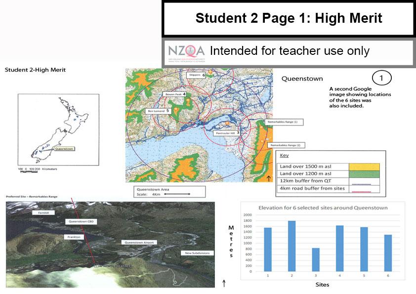
5 Exemplar for internal assessment resource Geography for Achievement Standard Grade Boundary: High Merit 2. For Merit, the student needs to effectively apply spatial analysis, with guidance, to solve a geographic problem. This involves: collecting sufficient spatial data to address the geographic problem completing manipulations of the spatial data to produce an accurate layout related to the problem explaining, in detail, an appropriate solution, based on manipulations, that is supported by evidence. This student has investigated the geographic problem of finding the best possible site for a new cell phone tower to service the Queenstown area. The student has created an accurate layout (1) made up of a screen shot from Google Earth. This provides a clear indication of the terrain and location of possible sites. The map shows selected buffers for distances from Queenstown and nearby roads, and the graph shows the elevations of each site. The layout (1) overall shows that sufficient relevant spatial data has been collected, appropriate manipulations made, and correct geographic conventions applied. The student has explained in detail an appropriate solution (3), with some reference to the manipulations made. The solution is included, with an overview of the advantages and disadvantages of each of the possible sites (4). Detailed summaries are provided for each site (4) with some direct reference to the spatial data presented on the layout. To reach Excellence, the student could make more effective use of the spatial data to fully explain the solution. The student could further explain the advantages such as elevation providing line of sight, or explain the implications of weaknesses of the proposed site. NZQA 2014
6
 Distance to Q.")
7 Student 2 _ High Merit Summary of findings for each of the 6 locations: Site Name Position Elevation (m) 1 Remarkables Range (1) 45 02'23"S, '50"E 2 Remarkables 45 04'32"S, Range (2) '00"E 5 Ben Lomond 45 00'48"S, '48"E Slope Nearest road (km) Distance to Q. (m) % % % Problem: Where to locate a new cell phone tower to serve Queenstown? The problem results from black spots being experienced and limited reception in some areas. The best location for a new cell phone tower in the Queenstown region needs a location over 1500masl to ensure good reception, within 12km of the major town and within 4km of a major road. This shows the need for accessibility as well. Recommendation and Summaries for each site: Remarkables Range -1: PREFERRED SITE THAT MEETS ALL PARAMETERS. Evidence from the layout shows that site one meets all the guidelines. It is at an altitude of 1560masl showing that it will be high enough to provide reception to Queenstown and this is shown on the Google image It is on a slope of 11% which equates to 5 degrees. A disadvantage of this site is that it may be above the snowline in winter This site is easily accessed by SH6 and the Remarkables ski road. Even though parts of this road is unsealed, it is graded and easily accessible by 4x4. This site is also fairly close to Queenstown. This accessibility advantage will mean that the costs of construction and ongoing maintenance of the cell phone tower could be less than some of the other sites. Considering the advantages of this site I recommend that it is investigated by a team of structural engineers (3) Ben Lomond Peak 5: This site is in a good position from Queenstown as shown on the map. It is 1780masl and has a clear view of Queenstown, Fernhill and Kelvin Heights Peninsular. It is 4.1km to the nearest highway, (4) Gorge Road to Arthur s Point. It would enable good reception to most of the Queenstown area. However, it does have a relatively steep slope and in winter could be above the snow line. Access could also be secured by helicopter from Queenstown Airport.
8 Exemplar for internal assessment resource Geography for Achievement Standard Grade Boundary: Low Merit 3. For Merit, the student needs to effectively apply spatial analysis, with guidance, to solve a geographic problem. This involves: collecting sufficient spatial data to address the geographic problem completing manipulations of the spatial data to produce an accurate layout related to the problem explaining, in detail, an appropriate solution, based on manipulations, that is supported by evidence. This student has investigated the geographic problem of finding the best possible site for a new cell phone tower to service the Queenstown area. The student has collected data for six possible sites and completed manipulations to produce an accurate layout, one part of which is exemplified (1). An appropriate solution to the problem has clearly been based on the manipulations (2). Parts of the explanation are in detail when distance and elevations (3) are given. For a more secure Merit, the student could include more specific detailed evidence to support their solution. Detail could also be provided of the weaknesses of the alternative sites, which would emphasise the strengths of the recommended option. NZQA 2014


9 Student 3-Low Merit 6 Possible sites around Queenstown Key Peninsular Hill 1 Land over 1500 masl Land over 1200 masl 12km buffer 4km road buffer m 2 1 My solution to the problem of where to locate a new cell phone tower for the Queenstown region is to focus on the Peninsular Hill-Site 3. Position Elevation To Slope Queenstown Peninsular Hill 45 02'S, 'E 834masl 4.9km 5% The map clearly shows that it meets several of the criteria because it is so close to Queenstown. The 4km buffer shows that it clearly covers the CBD through to the Frankton Arm (2) where a lot of new development is going on This site has an access road and because it is so close the construction and maintenance would be easy The recommended elevation is 1500 metres, and Peninsular Hill is only 834 masl While its elevation is less than the other sites, it is closer to Queenstown and there are no hills blocking it to create black spots (3). The slope of this site If a second site was to be considered I would recommend one in the Remarkables Range which have a higher elevation and is relatively close
10 Exemplar for internal assessment resource Geography for Achievement Standard Grade Boundary: High Achieved 4. For Achieved, the student needs to apply spatial analysis, with guidance, to solve a geographic problem. This involves: collecting spatial data relevant to the geographic problem completing manipulations of the spatial data to produce a layout related to the problem explaining an appropriate solution, based on the manipulations, that is supported by evidence. This student has investigated the geographic problem of finding the best possible site for a new cell phone tower to service the Queenstown area. The student has collected spatial data relevant to the problem, such as site elevations, and distances from Queenstown. This data has been manipulated through the use of buffers and additional shading to produce a layout related to the problem (1). An appropriate solution has been explained through the comparison of the recommended site with three alternatives (3). Some reference to the layout (2) (4) has been made to show that the manipulations influenced the site selection. To reach Merit, the student could improve the accuracy of the layout (1) by applying geographic conventions to all images, e.g. scale and orientation. Both buffers need to be keyed and more clearly labelled to indicate what they are showing. The Google screen shot should be annotated, conventions applied and irrelevant information deleted. The slope for each site could also be determined and more closely examined, as this is a significant factor when selecting a site for the construction of a cell-phone tower. More effective use of the spatial data could add depth to the explanation. For example actual distances from Queenstown and accessibility of each site. NZQA 2014


11 Student 4-High Achieved Layout for Queenstown The problem is where to put the best cell phone tower? Map showing the 4 possible sites for a cell phone tower A graph and a second Google image completed the layout 22 Site 2 Ben Lomond Site 1 Bowen 1 Peak 1 Screenshot to show the best site Site 4 Garden Spur Site 3 Island Spur Site 1: Bowen Peak Key 1 Land over 1500 m asl Rivers Buffers 1=Bowen peak 2=Ben Lomond 3=Island Spur 4=Garden Spur
12 Student 4-High Achieved Finding the best site Cell phone towers My Recommendation Site No 1 Site Name Bowen Peak 2 Ben Lomond Island 3 spur Garden 4 Spur Elevation (m) Distance To Queenstown (m) Nearest Highway (m) Position 44 59'S, 'E 'S, 'E 'S, 'E 'S, 'E Slope Top of Mountain Flat slope between contours Flat on top of spur Area of flat land All of the 4 sites are in the 12km buffer zone of Queenstown and all meet the elevation requirements The site that I recommend for the location of a cell phone tower is Site 1. It is closest to Queenstown and closest to a major road, see map (2) Site 2 is also quite close, but it is the lowest site, only 1500masl and this could affect reception quality for some parts of Queenstown such as The two sites to the south of Queenstown are less accessible Site 3 could give very good reception because of uninterrupted view to the CBD, and it is similar in elevation to Site 1, but it is across the lake and there is only one unsealed road (3) These two sites have advantages of large relatively flat platforms for building, but the disadvantage of Garden Spur the 4 th site is its altitude The access and low cost of construction are in favour of Site 1. It has a good view of Queenstown and the surrounding area, see Google Earth image. This site would offer the best cell phone coverage (4).
13 Exemplar for internal assessment resource Geography for Achievement Standard Grade Boundary: Low Achieved 5. For Achieved, the student needs to apply spatial analysis, with guidance, to solve a geographic problem. This involves: collecting spatial data relevant to the geographic problem completing manipulations of the spatial data to produce a layout related to the problem explaining an appropriate solution, based on the manipulations, that is supported by evidence. This student has investigated the geographic problem of finding the best possible site for a new cell phone tower to service the Queenstown area. The student has collected relevant spatial data to solve the problem and created buffers to show distances to Queenstown (1). Each site has been commented on as to its suitability for solving the problem. The map has been used to support the explanation. Site 2 is identified as the best location and solution to the problem of cell phone reception. Some of the reasons given are based on the manipulations (2). For a more secure Achieved, the student could show application of basic geographic conventions to the presented data, such as scale and orientation. This spatial data should be presented as a layout. More spatial data, such as a 3D Google image could be included. This would provide the student with the opportunity to show relationships between the data. For example, elevations shaded on the map could be shown beside the 3D Google image to more clearly indicate the implications of terrain for cell phone reception. A more complete layout would enable the student to show clear links to the manipulations when explaining their solution. This would show more effective use of the spatial data. NZQA 2014
14 Student 5 Low Achieved 3 Site 1 This is the lowest of all sites. It is the second closest to a highway and the second closest to Queenstown. You can see the CBD and Arthur s Point from this site Site 2: This site is the closest to Queenstown and the CBD can be seen. This shows that reception quality will be good It is above the 1500masl needed for a cell phone tower (2) This site is quite steep which could make it difficult to access a track from Map of Queenstown showing 4 possible sites Land over 1500 m asl Rivers Buffers 4km 1 Site 3: This is also to the South of Queenstown and the highest site. There is a larger area of flat land on a gentle slope. It faces the Queenstown CBD.This site could be considered for a cell phone tower. Site 4:.This site is to the South of Queenstown on a long spur which is a gentle slope. It is the furthest away from Queenstown There is only one road and it is unsealed.
15 Exemplar for internal assessment resource Geography for Achievement Standard Grade Boundary: High Not Achieved 6. For Achieved, the student needs to apply spatial analysis, with guidance, to solve a geographic problem. This involves: collecting spatial data relevant to the geographic problem completing manipulations of the spatial data to produce a layout related to the problem explaining an appropriate solution, based on the manipulations, that is supported by evidence. This student has investigated the geographic problem of finding the best possible site for a new cell phone tower to service the Queenstown area. This student has collected some spatial data, and completed manipulations (1) such as creating buffers and adding shading to show general site elevations. An appropriate solution is explained with a valid reason (2). To reach Achieved, the student could improve the accuracy of the layout by applying basic geographic conventions such as title, scale etc. The naming conventions used on the layout need to be consistent with those used in the explanation of the solution. For example, Bowen Peak is identified by name in the recommendation, but shown on the map with a site number. The evidence provided is largely descriptive (3). This needs to be further developed to provide explanations supporting the recommendation. Overall, the evidence needs to more clearly reflect the quality expected of Level 7 of the New Zealand Curriculum. NZQA 2014
 There are two possible construction platforms on Bowen Peak the slope at the higher one is fairly steep A track gives")
16 Student 6-High Not Achieved Bowen peak Site 2 Site 1 Land over 1500 m Roads Rivers KEY Site 4 Site 3 1 Bowen Peak is the best site because it is closest to Queenstown and there are no other hills to block reception Blackouts are the reason a new cell phone tower is needed (2) There are two possible construction platforms on Bowen Peak the slope at the higher one is fairly steep A track gives access to the site (3) Sites 3 and 4 are quite close to Queenstown but they are much lower in elevation
Exemplar for Internal Achievement Standard. Mathematics and Statistics Level 1
 9103 Exemplar for Internal Achievement Standard Mathematics and Statistics Level 1 This exemplar supports assessment against: Achievement Standard 9103 Apply right-angled triangles in solving measurement
Exemplar for Internal Achievement Standard. Mathematics and Statistics Level 3
 Exemplar for Internal Achievement Standard Mathematics and Statistics Level 3 This exemplar supports assessment against: Achievement Standard Apply systems of simultaneous equations in solving problems
Give 4 advantages of using ICT in the collection of data. Give. Give 4 disadvantages in the use of ICT in the collection of data
 Give 4 advantages of using ICT in the collection of data can use a handheld GPS to get accurate location information which can be used to show data linked to specific locations within a GIS can collect
Exemplar for Internal Achievement Standard. Physics Level 1
 Exemplar for internal assessment resource Physics for Achievement Standard 90935 Exemplar for Internal Achievement Standard Physics Level 1 This exemplar supports assessment against: Achievement Standard
Level 3 Geography, 2016
 91426 914260 3SUPERVISOR S USE ONLY Level 3 Geography, 2016 91426 Demonstrate understanding of how interacting natural processes shape a New Zealand geographic environment 9.30 a.m. Wednesday 16 November
Exemplar for Internal Achievement Standard Science Level 1. Demonstrate understanding of the effects of astronomical cycles on planet Earth.
 Exemplar for Internal Achievement Standard Science Level 1 This exemplar supports assessment against: Achievement Standard 90954 Demonstrate understanding of the effects of astronomical cycles on planet
***When doing the lab report write-up, be sure to follow the guidelines.***
 Topographic Maps Lab Vocabulary: topography - study of the shapes and features of the earth's surface elevation - height above sea level bench mark - a point that has been accurately measured for its position
About places and/or important events Landmarks Maps How the land is, hills or flat or mountain range Connected to maps World Different countries
 What do you think you know about geography? About places and/or important events Landmarks Maps How the land is, hills or flat or mountain range Connected to maps World Different countries What do you
Exemplar for Internal Achievement Standard. Chemistry Level 1
 Exemplar for Internal Achievement Standard Chemistry Level 1 This exemplar supports assessment against: Achievement Standard 90930 Carry out a practical chemistry investigation An annotated exemplar is
Level 1 Geography, 2013
 91010 910100 1SUPERVISOR S Level 1 Geography, 2013 91010 Apply concepts and basic geographic skills to demonstrate understanding of a given environment 9.30 am Friday 22 November 2013 Credits: Four Achievement
Exemplar for Internal Achievement Standard. Geography Level 2
 Exemplar for Internal Achievement Standard Geography Level 2 This exemplar supports assessment against: Achievement Standard 91241 Demonstrate geographic understanding of an urban pattern An annotated
Geography: Apply concepts and basic geographic skills to demonstrate understanding of a given environment (91010)
") Assessment Schedule 2013 NCEA Level 1 Geography (91010) 2013 page 1 of 8 Geography: Apply concepts and basic geographic skills to demonstrate understanding of a given environment (91010) Evidence Statement
Assessment Schedule 2013 NCEA Level 1 Geography (91010) 2013 page 1 of 8 Geography: Apply concepts and basic geographic skills to demonstrate understanding of a given environment (91010) Evidence Statement
Level 3 Geography, 2016
 91426 914260 3SUPERVISOR S USE ONLY Level 3 Geography, 2016 91426 Demonstrate understanding of how interacting natural processes shape a New Zealand geographic environment 9.30 a.m. Wednesday 16 November
Wayne E. Sirmon GEO 301 World Regional Geography
 Wayne E. Sirmon GEO 301 Geography 301 Geography 301 MAP: A graphic representation of a portion of the earth s surface dawn to scale, as seen from above. Types of Maps Climate maps give general information
Introduction to Contour Maps
 Your web browser (Safari 7) is out of date. For more security, comfort and Activityengage the best experience on this site: Update your browser Ignore Introduction to Contour Maps What information does
Level 1 Geography PROGRAMME OVERVIEW 2014
 Ruawai College Social Sciences Department Level 1 Geography PROGRAMME OVERVIEW 2014 Topic/Theme EXTREME NATURAL EVENTS: TSUNAMIS Case Study: 2004 Indian Ocean Tsunami/Boxin g Day Tsunami, Indian Ocean
Date: UNI. world. *Dedicated to
 Name: Date: UNI IT THREE 2D and 3D model s of the natural world *Dedicated to Name: Date: ABSTRACT T AND RATIONALE A topographic map is a type of map that depicts the detail and quantitative representation
Exemplar for Internal Achievement Standard. Chemistry Level 3
 Exemplar for Internal Achievement Standard Chemistry Level 3 This exemplar supports assessment against: Achievement Standard 91388 Demonstrate understanding of spectroscopic data in chemistry. An annotated
Level 3 Geography, 2016
 91426 914260 3SUPERVISOR S USE ONLY Level 3 Geography, 2016 91426 Demonstrate understanding of how interacting natural processes shape a New Zealand geographic environment 9.30 a.m. Wednesday 16 November
Lab Topographic Maps. Name: Partner: Purpose. Background Information
 Lab Topographic Maps Name: Partner: Purpose The purpose of this lab is to familiarize you with graphic representations of the Earth s surface primarily maps. Simple line maps show the spatial relationship
Using Geography to Plan Civil War Campsites
 Jake Gordon Civil War Campsite Mapping Lesson Plan pg1 Using Geography to Plan Civil War Campsites Overview: This lesson is designed for an 8 th grade social studies class during the Civil War unit. Students
In order to be adequately prepared for a test on this topic you should be able to:-
 Topic 2: MAPPING In order to be adequately prepared for a test on this topic you should be able to:- 1. Find and also provide both FOUR and SIX figure Area and Grid References 2. Calculate distances both
Exemplar for Internal Achievement Standard. Mathematics and Statistics Level 3
 Exemplar for internal assessment resource Mathematics and Statistics for Achievement Standard 91580 Exemplar for Internal Achievement Standard Mathematics and Statistics Level 3 This exemplar supports
Map reading notes. It is a very useful kind of map that shows the topography of an area, i.e whether it is flat, undulating, rugged or mountainous
 Introduction Map reading notes In the course of 2 or 3 years course, Candidates will be exposed to topographical maps from tropical countries such as Mauritius, Tanzania, Zimbabwe and Jamaica. Many of
Topographic Maps. More than a Road Map
 Topographic Maps More than a Road Map What is a Topographic Map? Scaled representation of features on the surface of the Earth such as roads, rivers, and plains Provides information about land elevations
Topographic Maps. Take Notes as you view the slides
 Topographic Maps Take Notes as you view the slides Lesson Objectives Define a topographic map and state its uses. Describe how contour lines show the elevations, shape, and slope of the land. Identify
New Zealand Population Distribution
 New Zealand Population Distribution Requirements: Internet access Web browser (e.g. Internet Explorer, Mozilla Firefox, Google Chrome)** An Esri Global Account **Please insure that pop ups are not blocked
Mathematics and Statistics Level 2
 Eemplar for Internal Achievement Standard Mathematics and Statistics Level This eemplar supports assessment against: Achievement Standard Apply systems of equations in solving problems An annotated eemplar
Different types of maps and how to read them.
 Different types of maps and how to read them. A map is a picture or representation of the Earth's surface, showing how things are related to each other by distance, direction, and size. Maps have been
YEAR 8 GEOGRAPHY. Landscapes & Landforms
 YEAR 8 GEOGRAPHY Landscapes & Landforms Due Date For Classes S, O, E, T: Assessment Name: Fantastic Formations Friday 0 th March 07 Mark: / Weighting: % SYLLABUS OUTCOMES TO BE ASSESSED: Locates and describes
Level 1 Geography, 2011
 91010 910100 1SUPERVISOR S Level 1 Geography, 2011 91010 Apply concepts and basic geographic skills to demonstrate understanding of a given environment 9.30 am ednesday Wednesday 2 November 2011 Credits:
Google Earth. Overview: Targeted Alaska Grade Level Expectations: Objectives: Materials: Grades 5-8
 Overview: Students become familiar with using the Google Earth interface to navigate around the planet. Using the zoom and tilt features, students practice moving around the planet with the navigation
CONTOUR MAPS This Enrichment4You e-guide provides a brief overview of contour maps In this e-guide you will: Sample file
 GEOLOGY CONTOUR MAPS CONTOUR MAPS This Enrichment4You e-guide provides a brief overview of contour maps In this e-guide you will: *Learn Basic Facts About Contour Maps *Make a 3-D Contour Map Geology Contour
Transport, Travel and Trade. Geography teaching resource years. Paula Owens.
 http://digimapforschools.edina.ac.uk Transport, Travel and Trade Paula Owens Geography teaching resource 7-11 years This is one of a series of teaching resources for use with Digimap for Schools. For more
Assessment Schedule 2014 Geography: Demonstrate understanding of how interacting natural processes shape a New Zealand geographic environment (91426)
") NCEA Level 3 Geography (91426) 2014 page 1 of 5 Assessment Schedule 2014 Geography: Demonstrate understanding of how interacting natural processes shape a New Zealand geographic environment (91426) Evidence
NCEA Level 3 Geography (91426) 2014 page 1 of 5 Assessment Schedule 2014 Geography: Demonstrate understanding of how interacting natural processes shape a New Zealand geographic environment (91426) Evidence
Level 1 Geography, 2016
 91010 910100 1SUPERVISOR S Level 1 Geography, 2016 91010 Apply concepts and basic geographic skills to demonstrate understanding of a given environment 9.30 a.m. Wednesday 16 November 2016 Credits: Four
Level 2 Geography, 2014
 91240 912400 2SUPERVISOR S Level 2 Geography, 2014 91240 Demonstrate geographic understanding of a large natural environment 2.00 pm Monday 10 November 2014 Credits: Four Achievement Achievement with Merit
DRAFT. Draft. 2 Analysis Exhibits
 2.0 Analysis Exhibits This document builds on the technical background report. Augmenting the technical background report and presented on the following pages are several new or updated maps including:
Level 1 Geography, 2017
 91010 910100 1SUPERVISOR S Level 1 Geography, 2017 91010 Apply concepts and basic geographic skills to demonstrate understanding of a given environment 9.30 a.m. Thursday 23 November 2017 Credits: Four
Tracking the Salt Front
 Tracking the Salt Front Students will use Hudson River salinity data to practice math skills as they track movements of the salt front in response to storms and other weather events. Objectives: Students
Level 1 Geography, 2015
 91007 910070 1SUPERVISOR S Level 1 Geography, 2015 91007 Demonstrate geographic understanding of environments that have been shaped by extreme natural event(s) 9.30 a.m. Thursday 12 November 2015 Credits:
Chapter 3 SECTION 1 OBJECTIVES
 Chapter 3 SECTION 1 OBJECTIVES Distinguish between latitude and longitude and locate coordinates on maps. Explain how latitude and longitude can be used to locate places on Earth s surface. Explain the
Mapping Earth. How are Earth s surface features measured and modeled?
 Name Mapping Earth How are Earth s surface features measured and modeled? Before You Read Before you read the chapter, think about what you know about maps Record your thoughts in the first column Pair
Level 2 Geography, 2016
 91242 912420 2SUPERVISOR S USE ONLY Level 2 Geography, 2016 91242 Demonstrate geographic understanding of differences in development 2.00 p.m. Wednesday 16 November 2016 Credits: Four Achievement Achievement
Using Map and Compass Together
 Using Map and Compass Together In situations where you foresee a potential evacuation on foot, where there are no roads, and no indication as to the direction of travel (i.e., road signs), it is recommended
56H. This system allows definition of points on the Earth s surface to within 100 meters. Page 20. Navigation Systems Basics of Maps
 Grid References Many maps are provided with the standard grid overlaying them. This provides a simple and accurate method for finding features on the map. It is a network of intersecting parallel lines
Unit 1, Lesson 3 What Tools and Technologies Do Geographers Use?
 Unit 1, Lesson 3 What Tools and Technologies Do Geographers Use? Geographers use a variety of tools and technologies in investigating geographic questions. Maps and globes both represent the earth, but
Notes and Summary pages:
 Topographic Mapping 8.9C Interpret topographical maps and satellite views to identify land and erosional features and predict how these shapes may be reshaped by weathering ATL Skills: Communication taking
Name Class Date. For each pair of terms, explain how the meanings of the terms differ.
 Skills Worksheet Chapter Review USING KEY TERMS For each pair of terms, explain how the meanings of the terms differ. 1. true north and magnetic north 2. latitude and longitude 3. equator and prime meridian
Write a report (6-7 pages, double space) on some examples of Internet Applications. You can choose only ONE of the following application areas:
 on some examples of Internet Applications. You can choose only ONE of the following application areas:") UPR 6905 Internet GIS Homework 1 Yong Hong Guo September 9, 2008 Write a report (6-7 pages, double space) on some examples of Internet Applications. You can choose only ONE of the following application
UPR 6905 Internet GIS Homework 1 Yong Hong Guo September 9, 2008 Write a report (6-7 pages, double space) on some examples of Internet Applications. You can choose only ONE of the following application
Level 1 Geography, 2017
 91007 910070 1SUPERVISOR S Level 1 Geography, 2017 91007 Demonstrate geographic understanding of environments that have been shaped by extreme natural event(s) 9.30 a.m. Thursday 23 November 2017 Credits:
Unit 1, Lesson 2. What is geographic inquiry?
 What is geographic inquiry? Unit 1, Lesson 2 Understanding the way in which social scientists investigate problems will help you conduct your own investigations about problems or issues facing your community
MAP STUDY: INTERPRETATION OF SURVEY MAPS
 MAP STUDY: INTERPRETATION OF SURVEY MAPS Types and Elements of Maps Maps are drawn to represent the Earth on a piece of paper. Maps are used widely to represent the Earth. Maps use signs and symbols in
Marking Scheme Field Work. 6 International Geography Olympiad. Brisbane
 Marking Scheme Field Work th 6 International Geography Olympiad Brisbane June 2006 Question - Map - 7 Marks Mark out of 4 and divide by 2 at the end. (Sample map was provided to markers.) Shading according
Landmarks Paula Owens 5 7 years
 Landmarks Paula Owens Geography teaching resource 5 7 years This is one of a series of teaching resources for use with Digimap for Schools. For more details about this service, visit http://digimapforschools.edina.ac.uk
TEACHER PAGE Trial Version
 TEACHER PAGE Trial Version * After completion of the lesson, please take a moment to fill out the feedback form on our web site (https://www.cresis.ku.edu/education/k-12/online-data-portal)* Lesson Title:
Trigonometry Unit 5. Reflect previous TEST mark, Overall mark now. Looking back, what can you improve upon?
 1 U n i t 5 11C Date: Name: Tentative TEST date Trigonometry Unit 5 Reflect previous TEST mark, Overall mark now. Looking back, what can you improve upon? Learning Goals/Success Criteria Use the following
Level 1 Geography, 2017
 91008 910080 1SUPERVISOR S Level 1 Geography, 2017 91008 Demonstrate geographic understanding of population concepts 9.30 a.m. Thursday 23 November 2017 Credits: Four Achievement Achievement with Merit
Figure 4: Elements of weather, traditional instruments used to measure them and the measurement units. cumulus)
") Weather is the detailed conditions on a daily or perhaps weekly basis: it refers to many elements of the weather, all of which can be measured and forecasts made, such as wind direction and speed and the
Weather is the detailed conditions on a daily or perhaps weekly basis: it refers to many elements of the weather, all of which can be measured and forecasts made, such as wind direction and speed and the
GEOL 380: Earthquake Hazards in the Puget Sound Region (in class and assignment) Due in class Wednesday, Nov 109th
 Due in class Wednesday, Nov 109th") GEOL 380: Earthquake Hazards in the Puget Sound Region (in class and assignment) Due in class Wednesday, Nov 109th The purpose of this exercise/assignment is for you to gain practice and experience in
GEOL 380: Earthquake Hazards in the Puget Sound Region (in class and assignment) Due in class Wednesday, Nov 109th The purpose of this exercise/assignment is for you to gain practice and experience in
Suitability Analysis on Second Home Areas Selection in Smithers British Columbia
 GEOG 613 Term Project Suitability Analysis on Second Home Areas Selection in Smithers British Columbia Zhengzhe He November 2005 Abstract Introduction / background Data Source Data Manipulation Spatial
Level 2 Geography, 2014
 91243 912430 2SUPERVISOR S Level 2 Geography, 2014 91243 Apply geography concepts and skills to demonstrate understanding of a given environment 2.00 pm Monday 10 November 2014 Credits: Four Achievement
DATA APPLIANCE FOR ARCGIS
 DATA APPLIANCE FOR ARCGIS Data Appliance for ArcGIS Provides Access to Multi-Scale Basemaps Down to Medium Scale Levels Worldwide And Large Scale for Most of the World The Data Appliance includes Several
GEOGRAPHY. Smestow School. Mathematics
 GEOGRAPHY Smestow School Mathematics Parents Guide 2016-2017 AIMS The Geography curriculum taught at Smestow aims to enable ALL students to have a balanced geographical education. The work will give them
BEFORE THE HEARINGS PANEL FOR THE QUEENSTOWN LAKES PROPOSED DISTRICT PLAN AND
 BEFORE THE HEARINGS PANEL FOR THE QUEENSTON LAKES PROPOSED DISTRICT PLAN IN THE MATTER of the Resource Management Act 1991 AND IN THE MATTER of Hearing Stream 9 Resort Zones MEMORANDUM OF COUNSEL ON BEHALF
ORIENTEERING. The challenge is to use the map to decide the best route to complete the course in the quickest time. Orienteering Map. Compass.
 ORIENTEERING Orienteering is similar to a cross-country race but you navigate using a map instead of following a set course. It is an outdoor sport where competitors navigate their own way, you can run,
Directed Reading. Section: Types of Maps
 Skills Worksheet Directed Reading Section: Types of Maps 1. What are some of the characteristics of an area shown on maps used by Earth scientists? a. types of animals, types of plants, types of minerals
Chapter 1 Overview of Maps
 Chapter 1 Overview of Maps In this chapter you will learn about: Key points when working with maps General types of maps Incident specific maps Map legend and symbols Map sources A map is a navigational
Saskatchewan s Early Trade Routes: The Impact of Geography on Trade
 Saskatchewan s Early Trade Routes: The Impact of Geography on Trade Lesson Overview In this lesson, students will compare and contrast prehistoric First Nations trade routes and trade goods with the routes
A Basic Introduction to Geographic Information Systems (GIS) ~~~~~~~~~~
 ~~~~~~~~~~") A Basic Introduction to Geographic Information Systems (GIS) ~~~~~~~~~~ Rev. Ronald J. Wasowski, C.S.C. Associate Professor of Environmental Science University of Portland Portland, Oregon 3 September
A Basic Introduction to Geographic Information Systems (GIS) ~~~~~~~~~~ Rev. Ronald J. Wasowski, C.S.C. Associate Professor of Environmental Science University of Portland Portland, Oregon 3 September
GEOGRAPHY: PAPER II MARKING GUIDELINES
 GRADE 11 EXAMINATION NOVEMBER 2007 GEOGRAPHY: PAPER II MARKING GUIDELINES Time: 1½ hours 100 marks The marking guide is a working document prepared for use by teachers as they assess the Grade 11 externally
A journey through the earth history of Australia s Coastal Wilderness Part 3 The backdrop - a 70 million year old plain
 A journey through the earth history of Australia s Coastal Wilderness Part 3 The backdrop - a 70 million year old plain Monaro Plain 3. The Cretaceous Plain The western horizon behind Moruya is dominated
ENGRG Introduction to GIS
 ENGRG 59910 Introduction to GIS Michael Piasecki March 17, 2014 Lecture 08: Terrain Analysis Outline: Terrain Analysis Earth Surface Representation Contour TIN Mass Points Digital Elevation Models Slope
WJEC Eduqas GCSE (9-1) GEOGRAPHY B
 GEOGRAPHY B") WJEC Eduqas GCSE (9-1) GEOGRAPHY B Additional sample questions for Theme 2 Candidate name.. Question Mark (a) (i) /2 (a) (ii) /4 (a) (iii) /4 (a) (iv) /3 (b) (i) /4 (b) (ii) /6 (c) (i) /2 (c) (ii) /1 (c)
WJEC Eduqas GCSE (9-1) GEOGRAPHY B Additional sample questions for Theme 2 Candidate name.. Question Mark (a) (i) /2 (a) (ii) /4 (a) (iii) /4 (a) (iv) /3 (b) (i) /4 (b) (ii) /6 (c) (i) /2 (c) (ii) /1 (c)
Exemplar for Internal Achievement Standard. Earth and Space Science Level 2
 Exemplar for internal assessment resource Earth and Space Science for Achievement Standard 91188 Exemplar for Internal Achievement Standard Earth and Space Science Level 2 This exemplar supports assessment
Topographic Maps and Landforms Geology Lab
 Topographic Maps and Landforms Geology Lab Ray Rector: Instructor Today s Lab Activities 1) Discussion of Last Week s Lab 2) Lecture on Topo Maps and Elevation Contours 3) Construct Topographic Maps and
Earth and Space: Topographic Maps Satellite Images
 Earth and Space: Topographic Maps Satellite Images Earth and Space: Formative Assessment Activities for Earth and Space Topographic Maps Satellite Images Teacher Pages Purpose The purpose of this station
Guided Notes Topographic Maps
 Guided Notes Topographic Maps Map scale Straight line distance Curved line distance Rules of Isolines Contour Lines Hachured Lines Possible elevations Slope & Gradient Direction of River Flow Topographic
YEAR 7 REVISION BOOKLET
 YEAR 7 REVISION BOOKLET Assessment checklist 1. To be able to define Geography. 2. Give examples of what we study in geography 3. Group what we study into the three major areas of geography 4. To be able
GRAAD 12 NATIONAL SENIOR CERTIFICATE GRADE 12
 GRAAD 12 NATIONAL SENIOR CERTIFICATE GRADE 12 GEOGRAPHY P1 FEBRUARY/MARCH 2013 MARKS: 300 TIME: 3 hours This question paper consists of 11 pages and a 12-page annexure. Geography/P1 2 DBE/Feb. Mar. 2013
Designing GIS Databases to Support Mapping and Map Production Charlie Frye, ESRI Redlands Aileen Buckley, ESRI Redlands
 Designing GIS Databases to Support Mapping and Map Production Charlie Frye, ESRI Redlands Aileen Buckley, ESRI Redlands 1 Designing GIS Databases to Support Mapping and Map Production Charlie Frye, ESRI
GLOBE Data Explorations
 Data at Altitude: A GLOBE Data Exploration Purpose Students learn how temperature varies with altitude while exploring GLOBE air temperature data collected at different elevations. Overview Students analyze
Understanding elevation and derivative layers
 Understanding elevation and derivative layers ArcGIS makes it easy to work with elevation data by offering a dynamic world elevation service (TopoBathy) and a specific land elevation (Terrain). These services
MeteoSwiss acceptance procedure for automatic weather stations
 MeteoSwiss acceptance procedure for automatic weather stations J. Fisler, M. Kube, E. Grueter and B. Calpini MeteoSwiss, Krähbühlstrasse 58, 8044 Zurich, Switzerland Phone:+41 44 256 9433, Email: joel.fisler@meteoswiss.ch
ENHANCING ROAD SAFETY MANAGEMENT WITH GIS MAPPING AND GEOSPATIAL DATABASE
 Abstract ENHANCING ROAD SAFETY MANAGEMENT WITH GIS MAPPING AND GEOSPATIAL DATABASE Dr Wei Liu GHD Reliable and accurate data are needed in each stage of road safety management in order to correctly identify
Chapter 02 Maps. Multiple Choice Questions
 Chapter 02 Maps Multiple Choice Questions 1. Every projection has some degree of distortion because A. a curved surface cannot be represented on a flat surface without distortion. B. parallels and meridians
Erosional Features. What processes shaped this landscape?
 Have you ever looked at the land around you and wondered what processes shaped what you see? Perhaps you see mountains, valleys, rivers, or canyons. Do you know how long these geologic features have been
St. James C of E Primary School
 St. James C of E Primary School Geography Policy St. James C of E Primary School Geography Policy Written by: Lisa Harford Written: April 2016 Reviewed: April 2018 1. Introduction Geography is concerned
Subject: Geography Scheme of Work: B1 to B6 Mastery tiles. Term: Autumn/Spring/Summer
 Subject: Geography Scheme of Work: B1 to B6 Mastery tiles Term: Autumn/Spring/Summer Topic / Unit(s) Overview / Context Introduction to geography. An introduction to geography including basic map skills
Geospatial Big Data Analytics for Road Network Safety Management
 Proceedings of the 2018 World Transport Convention Beijing, China, June 18-21, 2018 Geospatial Big Data Analytics for Road Network Safety Management ABSTRACT Wei Liu GHD Level 1, 103 Tristram Street, Hamilton,
Introduction to GIS. Geol 4048 Geological Applications of Remote Sensing
 Introduction to GIS Geol 4048 Geological Applications of Remote Sensing GIS History: Before Computers GIS History Using maps for a long time Dr. Roger F. Tomlinson Father of GIS He was an English geographer
Suggested volcano pattern in relation to the earthquake pattern and topography Learning Segment 7.1
 Teacher questions to prompt student observations of patterns : Describe the earthquake pattern. (Learning Segment 5.6) Describe the volcano pattern. (Learning Segment 6.5) Describe the volcano pattern
Looking at Communities: Comparing Urban and Rural Neighborhoods
 Looking at Communities: Comparing Urban and Rural Neighborhoods OVERVIEW & OBJECTIVES Our urban areas have become so dominant that frequently the children we teach have no connection with and very few
Topographical Maps ANSWER KEY- Assignment 6
 Topographical Maps ANSWER KEY- Assignment 6 Question 1 (To be answered using toposheet 45 D/7, Grid reference 76 to 85) 1. Cite two differences between the Sipu River and the Mahadeviyo Nala? Sipu River
Flooding on the Somerset Levels. ArcGIS Online
 Flooding on the Somerset Levels ArcGIS Online Using this resource This resource has been written to help teachers make use of the ArcGIS Online program. It provides; guidance on how to use the program
Representivity of wind measurements for design wind speed estimations
 Representivity of wind measurements for design wind speed estimations Adam Goliger 1, Andries Kruger 2 and Johan Retief 3 1 Built Environment, Council for Scientific and Industrial Research, South Africa.
B. Topographic maps are also called. contour maps
 Topographic Maps Introduction A. Topographic maps are essential tools in geologic and engineering studies because they show the configuration of Earth's surface in remarkable detail and permit one to measure
Module 2, Investigation 1: Briefing Where do we choose to live and why?
 Module 2, Investigation 1: Briefing Background Why do you live where you live? Where do people choose to live? Why do they choose those places? People have lived on Earth for thousands of years. Throughout
DATA DISAGGREGATION BY GEOGRAPHIC
 PROGRAM CYCLE ADS 201 Additional Help DATA DISAGGREGATION BY GEOGRAPHIC LOCATION Introduction This document provides supplemental guidance to ADS 201.3.5.7.G Indicator Disaggregation, and discusses concepts
Maps. 3. Which altitude of Polaris could be observed in New York State?
 Name: Date: 1. For an observer in New York State, the altitude of Polaris is 43 above the northern horizon. This observer s latitude is closest to the latitude of A. New York City B. Utica 3. Which altitude