Accessibility Instruments in Planning Practice Spatial Network Analysis for Multi-Modal Transport Systems (SNAMUTS): Adelaide
|
|
|
- Terence Fleming
- 5 years ago
- Views:
Transcription
1 Accessibility Instruments in Planning Practice Spatial Network Analysis for Multi-Modal Transport Systems (SNAMUTS): Adelaide Prof Carey Curtis, Dr Jan Scheurer, Roger Mellor, Oscar Thomson Curtin University, Perth
2 Day 1 - Agenda 3:00 Welcome & Introductions 3:10 Project Objectives 3:15 Accessibility experience - Pre- Workshop 3:25 Introduction to SNAMUTS 3:35 SNAMUTS Adelaide: Current Accessibility 3:50 Afternoon tea 4:00 Accessibility questions for Adelaide
3 The ARC project. Continue the development of an interactive accessibility tool to assist in examining scenarios for activity centres framed around: the accessibility of the transport network, and the accessibility of place. 25 Cities in Australia, Europe, N. America & Asia
4 ARC objectives SNAMUTS as a benchmarking tool SNAMUTS methodology and robustness in a range of city types SNAMUTS USE & USEABILITY
5 EU COST Project Concerted Action in Research Accessibility Instruments in Planning Practice 22 European Countries & Australia Local (National) Workshops USE & USEABILITY
6 The purpose of SNAMUTS the quantification of the effect of - transport infrastructure improvements and modifications, and - of land use intensification on the accessibility of activity centres and corridors by different modes of transport (primarily public transport).
7 The tool can enable the testing of a range of scenarios to assist in the development of a hierarchy of activity centres by exploring and measuring the effect of the following scenarios across the metropolitan area Changes in public transport accessibility resulting from service improvements Comparative accessibility by car and by public transport (to examine how and where public transport can be more competitive) Exploring potential changes in activity levels (different patterns of jobs/residents defined by regional/local catchments) in each activity centre


8 Context - Land use transport integration in Australian cities clear policy intentions in Metropolitan Plans but selective implementation resulted in low density and dispersed form not only are cities spread out but land use activity is scattered.. a myriad of centres possibility of supplying a high frequency public transport system to serve these centres a challenge.
9 developing the decision tool

10 Perth to Mandurah Railway Opened in December 2007 and may have been the largest single infrastructure insertion to date into Perth s public transport system. Could we quantify its benefits for mobility and accessibility locally and across the metropolitan region?

11 Compiling a Base Network How can we measure distance (or travel impediment) in ways that come close to user perceptions and motivations? Public transport users are only marginally interested in geographical distance: the main factors of travel disutility are travel time, and the ubiquity of travel opportunities (service frequency)
12 spatial network analysis for multimodal urban transport systems (SNAMUTS) Purpose: To assess and quantify how transport networks, in terms of geographical configuration and service levels, perform in their urban context (distribution of land use activities). SNAMUTS was inspired by the Space Syntax approach (Hillier and Hanson, 1984), and the Multiple Centrality Analysis tool (Porta, Crucitti and Latora, 2006) SNAMUTS is a supply-side tool: it does not provide predictions about usage or capacity levels. Rather it asks: What is the role of the public transport system in facilitating movement and activity across a city region?


13 network connectivity Create a network effect by local optimisation to routes, good interchange facilities, high and standardised service frequencies, timetable coordination and the presence of orbital/crosssuburban routes to maximise market penetration for public transport. Map Sources:
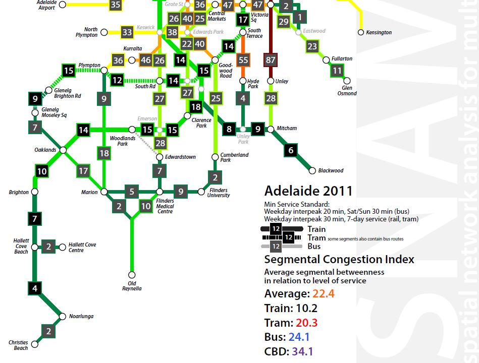
, 30 min weekdays and 7 day service (rail) Identifying activity nodes: SNAMUTS matrix of activity nodes derived from activity centre hierarchy in strategic")
14 compiling a base network Spatial separation or impediment measure: Travel time divided by service frequency (d=4t/ f) Minimum service standard (SNAMUTS 23): 20 min frequency during the weekday interpeak, 30 min on Sat/Sun (buses, trams), 30 min weekdays and 7 day service (rail) Identifying activity nodes: SNAMUTS matrix of activity nodes derived from activity centre hierarchy in strategic planning documents and from field observation. Adelaide s average activity node catchment is approximately 10,000 residents and jobs.
15 overview of snamuts indicators 1. Service intensity: How much operational input is required to run the network at the defined minimum service standard? 2. Closeness centrality: What is the ease of movement between a node and the rest of the network? 3. Degree centrality: How many transfers separate a node from the rest of the network? 4. Catchment size of 30-minute travel time contour: How many residents and jobs are accessible within half an hour? 5. Betweenness centrality: How are travel opportunities geographically distributed across the network? 6. Network Stress: Where on the network can we find mismatches between route or node significance and level of service? 7. Nodal connectivity: How are activity centres placed to act as hubs for the network?
16 adelaide: service intensity Number of vehicles/train sets required in simultaneous operation for the minimum standard network (20 min weekdays, 30 min weekends for trams and buses, 30 minutes weekdays for trains) Trains Trams total: per 100,000 pop (2011) Buses 191
17 comparison of service intensity per 100,000 inhabitants (snamuts 23 standard) Adelaide 16.3 Sydney 14.3 Melbourne 13.1 Perth 12.0 Brisbane 11.4 Auckland 9.2
18 service intensity: what does and what doesn t this index tell us? Operational efficiency: Networks dominated by slow modes (especially buses) tend to require greater operational input (in number of vehicles/drivers) than networks dominated by fast modes (especially light or heavy rail). Performance expectation: Does a higher outlay of operational resources consistently result in better public transport accessibility and network performance?
 Source: Porta, Crucitti and Latora")
19 understanding networks Networks have topological properties (how many degrees of separation from A to B) and metric properties (how many units of distance/impediment from A to B) Source: Porta, Crucitti and Latora 2006
20 closeness centrality What is the ease of movement across the network? [smaller values indicate better accessibility performance]
21 comparison of closeness centrality average per network Auckland 59.0 Perth 59.9 Adelaide 61.1 Melbourne 62.3 Brisbane 64.1 Sydney 81.5
22 closeness centrality: what does and what doesn t this index tell us? Ease of movement: Closeness scores are a spatial separation measure for the activity centre network. They are inflated by (1) dispersed settlement patterns, (2) detours forced by geographical barriers or missing links, (3) slow travel speeds, (4) low service frequencies, or a combination of several of the above. Network size: Larger networks with a greater number of activity centres will generally produce higher (poorer) average closeness centrality scores than smaller ones.

23 degree centrality What is the transfer intensity of the network? [smaller values indicate better accessibility performance]
24 comparison of degree centrality average per network Melbourne 0.91 Brisbane 0.91 Auckland 0.95 Perth 1.03 Sydney 1.04 Adelaide 1.09
25 degree centrality: what does and what doesn t this index tell us? Network organisation: Is the public transport network organised around a modal hierarchy with lower-capacity modes acting as feeders and distributors to higher-capacity nodes (greater transfer intensity)? Or do the networks of modes with different performance coexist (compete?) in spatial terms (lower transfer intensity)?
26 contour catchments How many residents and jobs can you access within 30 minutes from each activity node? Some assumptions: One transfer is allowed within 30 min, but only between services that both run at least every 15 min A flat deduction applies for making the transfer, equivalent to the actual average transfer time across the network (usually between 6 and 8 minutes)
27 comparison of network coverage and average contour catchments percentage of metropolitan residents and jobs Sydney 53.9% 8.2% Melbourne 49.1% 9.3% Adelaide 48.1% 10.8% Perth 44.5% 11.7% Brisbane 35.9% 10.0% Auckland 32.8% 10.2%
28 network coverage and contour catchments: what do and what don t these indexes tell us? Network coverage describes the quantity of people with access to public transport, while the contour catchment measure expands this with a qualitative message (how many people can you access within 30 minutes?) Ideally, a city would score 100% on both counts. What are the barriers in each metropolitan region that currently work against this (or merely separate present conditions from world best practice)? And what are the levers a city has to close these gaps?
29 betweenness centrality How are travel opportunities distributed across the network? Betweenness centrality defines preferred travel paths between each pair of nodes, and counts them at nodes and route segments to determine their strategic significance
30
31 comparison of global and nodal betweenness total/average average per network Sydney 1, Melbourne Perth Brisbane Adelaide Auckland
32 betweenness centrality: what does and what doesn t this index tell us? (i) Public transport movement energy : Betweenness centrality attempts to quantify the presence of public transport opportunities in each centre, and across the metropolitan area, as well as visualise how this presence flows across the network. Balanced and unbalanced nodes/places, stressed locations and routes: Betweenness can help identify pressures on network elements originating from either their land use or their transport function (or both in conjunction). Betweenness scores are not necessarily proportional to usage levels, but correlations with usage can point to under- or over-utilised potential for public transport movement.
33 betweenness centrality: what does and what doesn t this index tell us? (ii) The betweenness centrality index rewards urban compactness/contiguity as well as high settlement density two influences that can either amplify or neutralise each other in the real world. Is this bias towards urban compactness a problem for this index?
34
35 network stress: what does and what doesn t this index tell us? A troubleshooting tool to pinpoint mismatches in public transport supply and (potential) demand (ie. demand as derived from urban form and network configuration) Includes a feedback loop, as isolated measures to improve service levels to relieve stress (ie. frequency upgrades) will also add to network stress through greater ease of movement. Responds most vigorously to more comprehensive solutions, such as network reconfigurations and mode upgrades.
36 comparison of network stress average per network Perth 18.5 Brisbane 21.4 Melbourne 21.6 Adelaide 22.4 Auckland 24.7 Sydney 25.0


37 nodal connectivity To what extent do network nodes function as hubs for movement? The connectivity index measures each node s connectedness to other nodes, and its capacity for making transfers or stopovers.

38 comparison of nodal connectivity average per network Melbourne 82 Sydney 77 Brisbane 42 Perth 19 Adelaide 12 Auckland NA
39 6 key snamuts indicators Closeness Centrality Ease of Movement Degree Centrality Transfer Intensity 30-minute Contour Catchment Betweenness Centrality Geographical Distribution of Travel Opportunities Network Stress Identifying Squeeze Points and Underused Potential Nodal Connectivity Attractiveness for PT-oriented Land Use Intensification Composite Index: combines all 6 measures by allocating between 0 and 10 points to each (maximum 60)


40 snamuts composite index Good, average and poor public transport accessibility on a scale map
41 snamuts adelaide: preliminary findings Adelaide has the highest proportion of network coverage (residents and jobs within walking distance to public transport) at a minimum service frequency standard of 30 minutes (weekday interpeak in conjunction with 7-day operation) among Australian cities. Adelaide provides for the highest operational input (vehicles or train sets in simultaneous revenue service) relative to population of all Australian cities. Adelaide has a CBD surface network whose connectivity and provision for multidirectional movement is second only to Melbourne among Australian cities (though it remains less legible due to the greater dominance of buses over trams in Adelaide).
42 snamuts adelaide: preliminary findings Adelaide s uncomplicated urban geography between the coastline and the Adelaide Hills facilitates the provision of a well-connected network across most of the urbanised area (however, low service frequencies on rail lines as well as on orbital and secondary radial bus links impact negatively on its transfer-friendliness). The modal hierarchy between trains, trams and buses remains relatively flat, and efficient task-sharing between modes of different performance (eg. buses feeding rail) remains patchy and underdeveloped. The network is (even) more dependent on channelling movement through the CBD area than any other Australian (or overseas) city, resulting in the second highest measure of central city network stress across Australia.
43 Accessibility Questions for Adelaide Explore the SNAMUTS maps and ask questions How useful are these maps to you? What are the accessibility questions for the Adelaide metro area? Aim to work on questions in preparation for day 2
accessibility instruments in planning practice
 accessibility instruments in planning practice Spatial Network Analysis for Multi-Modal Transport Systems (SNAMUTS): Helsinki Prof Carey Curtis, Dr Jan Scheurer, Curtin University, Perth - RMIT University,
Accessibility Instruments in Planning Practice Spatial Network Analysis for Multi-Modal Transport Systems (SNAMUTS): Adelaide
: Adelaide") Accessibility Instruments in Planning Practice Spatial Network Analysis for Multi-Modal Transport Systems (SNAMUTS): Adelaide Prof Carey Curtis, Dr Jan Scheurer, Roger Mellor, Oscar Thomson Curtin University,
Accessibility Instruments in Planning Practice Spatial Network Analysis for Multi-Modal Transport Systems (SNAMUTS): Adelaide Prof Carey Curtis, Dr Jan Scheurer, Roger Mellor, Oscar Thomson Curtin University,
Benchmarking public transport accessibility in Australasian cities
 Curtis and Scheurer 35 th Australasian Transport Research Forum 2012 Benchmarking public transport accessibility in Australasian cities Carey Curtis (Curtin University) Jan Scheurer (RMIT University/Curtin
Developing harmonised indicators on urban public transport in Europe
 Developing harmonised indicators on urban public transport in Europe Hugo Poelman European Commission DG Regional and Urban GIS team Regional May 2015 context EU Cohesion European Regional Development
Benchmarking Accessibility and Public Transport Network Performance in Copenhagen and Perth
 Institute of Transport Studies, Monash University World Transit Research World Transit Research 1-1-2010 Benchmarking Accessibility and Public Transport Network Performance in Copenhagen and Perth Jan
Visitor Flows Model for Queensland a new approach
 Visitor Flows Model for Queensland a new approach Jason. van Paassen 1, Mark. Olsen 2 1 Parsons Brinckerhoff Australia Pty Ltd, Brisbane, QLD, Australia 2 Tourism Queensland, Brisbane, QLD, Australia 1
Performance measures for public transport accessibility: Learning from international practice
 The Journal of Transport and Land Use http://jtlu.org Vol. 10 No. 1 [2017] pp. 93 118 Performance measures for public transport accessibility: Learning from international practice Carey Curtis Curtin University
Foreword. Vision and Strategy
 GREATER MANCHESTER SPATIAL FRAMEWORK Friends of Walkden Station Consultation Response January 2017 Foreword Friends of Walkden Station are a group of dedicated volunteers seeking to raise the status and
Accessibility as an Instrument in Planning Practice. Derek Halden DHC 2 Dean Path, Edinburgh EH4 3BA
 Accessibility as an Instrument in Planning Practice Derek Halden DHC 2 Dean Path, Edinburgh EH4 3BA derek.halden@dhc1.co.uk www.dhc1.co.uk Theory to practice a starting point Shared goals for access to
How is public transport performing in Australia
 How is public transport performing in Australia CILTA Moving People Thursday 17 March 2011 Professor Corinne Mulley Institute of Transport and Logistics Studies Outline Measuring performance Australia
City sustainability: a transport perspective a journey continues
 Sustainable Development, Vol. 2 833 City sustainability: a transport perspective a journey continues K. Doust1,2, C. Wang1 & T. Doust2 1 Research Centre for Integrated Transport Innovation (rciti), University
Transit Time Shed Analyzing Accessibility to Employment and Services
 Transit Time Shed Analyzing Accessibility to Employment and Services presented by Ammar Naji, Liz Thompson and Abdulnaser Arafat Shimberg Center for Housing Studies at the University of Florida www.shimberg.ufl.edu
True Smart and Green City? 8th Conference of the International Forum on Urbanism
 ,, doi:10.3390/ifou-. True Smart and Green City? 8th Conference of the International Forum on Urbanism Conference Proceedings Paper Comparable Measures of Accessibility to Public Transport by the General
Transport Planning in Large Scale Housing Developments. David Knight
 Transport Planning in Large Scale Housing Developments David Knight Large Scale Housing Developments No longer creating great urban spaces in the UK (Hall 2014) Transport Planning Transport planning processes
Transit-Oriented Development. Christoffer Weckström
 Transit-Oriented Development Christoffer Weckström 31.10.2017 Outline Context of Transit-oriented Development Elements of Transit-oriented Development A short history of land use and transit integration
Assessing spatial distribution and variability of destinations in inner-city Sydney from travel diary and smartphone location data
 Assessing spatial distribution and variability of destinations in inner-city Sydney from travel diary and smartphone location data Richard B. Ellison 1, Adrian B. Ellison 1 and Stephen P. Greaves 1 1 Institute
Land use/transport integration: the vital role of our forgotten middle suburbs. March 2016
 Land use/transport integration: the vital role of our forgotten middle suburbs March 2016 Presented by Adjunct Professor John Stanley Institute of Transport and Logistics Studies (ITLS) The University
transportation research in policy making for addressing mobility problems, infrastructure and functionality issues in urban areas. This study explored
 ABSTRACT: Demand supply system are the three core clusters of transportation research in policy making for addressing mobility problems, infrastructure and functionality issues in urban areas. This study
Development of modal split modeling for Chennai
 IJMTES International Journal of Modern Trends in Engineering and Science ISSN: 8- Development of modal split modeling for Chennai Mr.S.Loganayagan Dr.G.Umadevi (Department of Civil Engineering, Bannari
The National Spatial Strategy
 Purpose of this Consultation Paper This paper seeks the views of a wide range of bodies, interests and members of the public on the issues which the National Spatial Strategy should address. These views
Beyond Mobility - Understanding and comparing urban accessibility in European Cities. Guy Hitchcock, Knowledge Leader
 Beyond Mobility - Understanding and comparing urban accessibility in European Cities Guy Hitchcock, Knowledge Leader 2 Study on improving the understanding of urban accessibility and road congestion in
Metrolinx Transit Accessibility/Connectivity Toolkit
 Metrolinx Transit Accessibility/Connectivity Toolkit Christopher Livett, MSc Transportation Planning Analyst Research and Planning Analytics Tweet about this presentation #TransitGIS OUTLINE 1. Who is
Public Transport and Land Use Integration in Melbourne and Hamburg: Can Comparative Network Performance Provide a Sense of Future Direction?
 Public Transport and Land Use Integration in Melbourne and Hamburg: Can Comparative Network Performance Provide a Sense of Future Direction? Public Transport and Land Use Integration in Melbourne and Hamburg:
Subject: Note on spatial issues in Urban South Africa From: Alain Bertaud Date: Oct 7, A. Spatial issues
 Page 1 of 6 Subject: Note on spatial issues in Urban South Africa From: Alain Bertaud Date: Oct 7, 2009 A. Spatial issues 1. Spatial issues and the South African economy Spatial concentration of economic
Data driven approaches to Urban Planning Experience from Derry/Londonderry
 Data driven approaches to Urban Planning Experience from Derry/Londonderry Anna Rose RTPI Belfast 11 th of September 1 June 26 07:47AM 2 The value of the City The space of the city is a theatre: playing
Measuring connectivity in London
 Measuring connectivity in London OECD, Paris 30 th October 2017 Simon Cooper TfL City Planning 1 Overview TfL Connectivity measures in TfL PTALs Travel time mapping Catchment analysis WebCAT Current and
The 3V Approach. Transforming the Urban Space through Transit Oriented Development. Gerald Ollivier Transport Cluster Leader World Bank Hub Singapore
 Transforming the Urban Space through Transit Oriented Development The 3V Approach Gerald Ollivier Transport Cluster Leader World Bank Hub Singapore MDTF on Sustainable Urbanization The China-World Bank
Land Use in the context of sustainable, smart and inclusive growth
 Land Use in the context of sustainable, smart and inclusive growth François Salgé Ministry of sustainable development France facilitator EUROGI vice president AFIGéO board member 1 Introduction e-content+
National Spatial Development Perspective (NSDP) Policy Coordination and Advisory Service
 Policy Coordination and Advisory Service") National Spatial Development Perspective (NSDP) Policy Coordination and Advisory Service 1 BACKGROUND The advances made in the First Decade by far supersede the weaknesses. Yet, if all indicators were
National Spatial Development Perspective (NSDP) Policy Coordination and Advisory Service 1 BACKGROUND The advances made in the First Decade by far supersede the weaknesses. Yet, if all indicators were
Interactive Visualization Tool (InViTo)
") Interactive Visualization Tool (InViTo) Stefano Pensa To cite this report: Stefano Pensa (2012) Interactive Visualization Tool (InViTo), in Angela Hull, Cecília Silva and Luca Bertolini (Eds.) Accessibility
Interactive Visualization Tool (InViTo) Stefano Pensa To cite this report: Stefano Pensa (2012) Interactive Visualization Tool (InViTo), in Angela Hull, Cecília Silva and Luca Bertolini (Eds.) Accessibility
Travel behavior of low-income residents: Studying two contrasting locations in the city of Chennai, India
 Travel behavior of low-income residents: Studying two contrasting locations in the city of Chennai, India Sumeeta Srinivasan Peter Rogers TRB Annual Meet, Washington D.C. January 2003 Environmental Systems,
How the science of cities can help European policy makers: new analysis and perspectives
 How the science of cities can help European policy makers: new analysis and perspectives By Lewis Dijkstra, PhD Deputy Head of the Economic Analysis Unit, DG Regional and European Commission Overview Data
CORRIDORS OF FREEDOM Access Management (Ability) Herman Pienaar: Director City Transformation and Spatial Planning
 Herman Pienaar: Director City Transformation and Spatial Planning") CORRIDORS OF FREEDOM Access Management (Ability) 2016 Herman Pienaar: Director City Transformation and Spatial Planning PLANNING DEVELOPMENT PROCESS RATHER THAN A PLAN CAPITAL INVESTMENT DEVELOPMENT FACILITATION
CORRIDORS OF FREEDOM Access Management (Ability) 2016 Herman Pienaar: Director City Transformation and Spatial Planning PLANNING DEVELOPMENT PROCESS RATHER THAN A PLAN CAPITAL INVESTMENT DEVELOPMENT FACILITATION
High speed network in Hauts-de-France Region. Värnamo, 17 th May 2018
 High speed network in Hauts-de-France Region Värnamo, 17 th May 2018 Hauts-de-France at the crossroads of the North-West Europe High speed train approach in France In the 1980s: will to link the main cities
Poland, European Territory, ESPON Programme Warsaw, 2 July 2007 STRATEGY OF THE ESPON 2013 PROGRAMME
 Poland, European Territory, ESPON Programme 2007-2013 Warsaw, 2 July 2007 STRATEGY OF THE ESPON 2013 PROGRAMME Territory matters Regional diversity as asset Territorial potentials increasing in importance
Decentralisation and its efficiency implications in suburban public transport
 Decentralisation and its efficiency implications in suburban public transport Daniel Hörcher 1, Woubit Seifu 2, Bruno De Borger 2, and Daniel J. Graham 1 1 Imperial College London. South Kensington Campus,
Travel Related Urban Zones in Finland
 Travel Related Urban Zones in Finland Theory of Urban Fabrics Seminar in Helsinki, SYKE, 24.10.2013 Mika Ristimäki, Maija Tiitu, Ville Helminen, Panu Söderström, Kari Oinonen Finnish Environment Institute
Together towards a Sustainable Urban Agenda
 Together towards a Sustainable Urban Agenda The City We (Youth) Want Preliminary findings from youth consultations Areas Issue Papers Policy Units 1.Social Cohesion and Equity - Livable Cities 2.Urban
CIV3703 Transport Engineering. Module 2 Transport Modelling
 CIV3703 Transport Engineering Module Transport Modelling Objectives Upon successful completion of this module you should be able to: carry out trip generation calculations using linear regression and category
European spatial policy and regionalised approaches
 Findings of the ESPON 2006 Programme COMMIN Final Conference 26-27 April 2007 European spatial policy and regionalised approaches by Dr. Kai BöhmeB ! Territory matters Structure of presentation! Territorial
Thilo Becker
 Friedrich List Faculty of Transport and Traffic Science, Chair of Transport Ecology CAN THE CONCEPT OF ENVIRONMENTAL JUSTICE IN TRANSPORT BE TRANSFERRED TO CITIES OF THE SOUTH? A CASE STUDY OF NAIROBI
Effects of a non-motorized transport infrastructure development in the Bucharest metropolitan area
 The Sustainable City IV: Urban Regeneration and Sustainability 589 Effects of a non-motorized transport infrastructure development in the Bucharest metropolitan area M. Popa, S. Raicu, D. Costescu & F.
Accessibility patterns: Bavaria Case Study 1
 EUROPA XXI Vol. 24, 2013, pp. 49-59 http://dx.doi.org/10.7163/eu21.2013.24.4 Institute of Geography and Spatial Organization Polish Academy of Sciences www.igipz.pan.pl Accessibility patterns: Bavaria
Session 3: Spatial Diagnosis of Mobility and Accessibility in Urban Mobility Systems
 MESTRADO EM ENGENHARIA CIVIL MESTRADO EM URBANISMO E ORDENAMENTO DO TERRITÓRIO MESTRADO EM PLANEAMENTO E OPERAÇÃO DE TRANSPORTES Urban Mobility Management Main lecturer: Prof. Rosário Macário Assistent:
Relationship between Spatial Configuration and Ferry, Bus and Railway Patronage in Brisbane CBD
 Relationship between Spatial Configuration and Ferry, Bus and Railway Patronage in Brisbane CBD Sima Vaez 1, Matthew Burke 2,Tooran Alizadeh 3 Email for correspondence: sima.vaezeslami@griffithuni.edu.au
THE ROLE OF REGIONAL SPATIAL PLANNING IN SUPPORTING LONG-TERM ECONOMIC GROWTH IN NORTHERN IRELAND
 THE ROLE OF REGIONAL SPATIAL PLANNING IN SUPPORTING LONG-TERM ECONOMIC GROWTH IN NORTHERN IRELAND Jenny Pyper Director 6 th Annual ICLRD Conference 20 January 2011 PURPOSE OF REGIONAL PLANNING Framework
The ESPON Programme. Goals Main Results Future
 The ESPON Programme Goals Main Results Future Structure 1. Goals Objectives and expectations Participation, organisation and networking Themes addressed in the applied research undertaken in ESPON projects
Forecasts from the Strategy Planning Model
 Forecasts from the Strategy Planning Model Appendix A A12.1 As reported in Chapter 4, we used the Greater Manchester Strategy Planning Model (SPM) to test our long-term transport strategy. A12.2 The origins
Towards a Co-ordinated Planning of Infrastructure and Urbanization
 Towards a Co-ordinated Planning of Infrastructure and Urbanization Problems, Solutions and Conditions for Success in the current Dutch Policy and Planning Practice Content of presentation Content of presentation
REGIONAL SDI DEVELOPMENT
 REGIONAL SDI DEVELOPMENT Abbas Rajabifard 1 and Ian P. Williamson 2 1 Deputy Director and Senior Research Fellow Email: abbas.r@unimelb.edu.au 2 Director, Professor of Surveying and Land Information, Email:
Data Collection. Lecture Notes in Transportation Systems Engineering. Prof. Tom V. Mathew. 1 Overview 1
 Data Collection Lecture Notes in Transportation Systems Engineering Prof. Tom V. Mathew Contents 1 Overview 1 2 Survey design 2 2.1 Information needed................................. 2 2.2 Study area.....................................
Note on Transportation and Urban Spatial Structure
 Note on Transportation and Urban Spatial Structure 1 By Alain Bertaud, Washington, ABCDE conference, April 2002 Email: duatreb@msn.com Web site: http://alain-bertaud.com/ http://alainbertaud.com/ The physical
PLANNING FOR TOD IN SMART CITIES
 PLANNING FOR TOD IN SMART CITIES Making transit a preferred choice, not the only choice! Dr. Yamini J. Singh*, Dr. Johannes Flacke^ and Prof. M.F.A.M. van Maarseveen^ * Founder Director, Planit, The Netherlands
Mapping cities by transit riders trajectories: The case of Brisbane, Australia. Citation Environment and Planning A, 2017, v. 49 n. 8, p.
 Title Mapping cities by transit riders trajectories: The case of Brisbane, Australia Author(s) Zhou, J; Corcoran, J; Borsellino, R Citation Environment and Planning A, 2017, v. 49 n. 8, p. 1707-1709 Issued
Mapping Accessibility Over Time
 Journal of Maps, 2006, 76-87 Mapping Accessibility Over Time AHMED EL-GENEIDY and DAVID LEVINSON University of Minnesota, 500 Pillsbury Drive S.E., Minneapolis, MN 55455, USA; geneidy@umn.edu (Received
GEOGRAPHY YEAR 11 ATAR 2019 COURSE OUTLINE
 GEOGRAPHY YEAR 11 ATAR 2019 COURSE OUTLINE Geography ATAR Year 11 Semester 1 Unit 1 Natural and ecological hazards 1 3 Geographical skills Mapping skills identify and interpret a variety of topographic
BROOKINGS May
 Appendix 1. Technical Methodology This study combines detailed data on transit systems, demographics, and employment to determine the accessibility of jobs via transit within and across the country s 100
Typical information required from the data collection can be grouped into four categories, enumerated as below.
 Chapter 6 Data Collection 6.1 Overview The four-stage modeling, an important tool for forecasting future demand and performance of a transportation system, was developed for evaluating large-scale infrastructure
6 th GLOBAL SUMMIT ON URBAN TOURISM 4 6 December 2017, Kuala Lumpur (Malaysia)
") 6 th GLOBAL SUMMIT ON URBAN TOURISM 4 6 December 2017, Kuala Lumpur (Malaysia) SUMMARY/CONCLUSIONS Esencan TERZIBASOGLU Director Destination Management and Quality eterzibasoglu@unwto.org 6TH GLOBAL SUMMIT
6 th GLOBAL SUMMIT ON URBAN TOURISM 4 6 December 2017, Kuala Lumpur (Malaysia) SUMMARY/CONCLUSIONS Esencan TERZIBASOGLU Director Destination Management and Quality eterzibasoglu@unwto.org 6TH GLOBAL SUMMIT
Joint-accessibility Design (JAD) Thomas Straatemeier
 Thomas Straatemeier") Joint-accessibility Design (JAD) Thomas Straatemeier To cite this report: Thomas Straatemeier (2012) Joint-accessibility Design (JAD), in Angela Hull, Cecília Silva and Luca Bertolini (Eds.) Accessibility
Joint-accessibility Design (JAD) Thomas Straatemeier To cite this report: Thomas Straatemeier (2012) Joint-accessibility Design (JAD), in Angela Hull, Cecília Silva and Luca Bertolini (Eds.) Accessibility
Estimating Large Scale Population Movement ML Dublin Meetup
 Deutsche Bank COO Chief Data Office Estimating Large Scale Population Movement ML Dublin Meetup John Doyle PhD Assistant Vice President CDO Research & Development Science & Innovation john.doyle@db.com
Assessing the Employment Agglomeration and Social Accessibility Impacts of High Speed Rail in Eastern Australia: Sydney-Canberra-Melbourne Corridor
 Assessing the Employment Agglomeration and Social Accessibility Impacts of High Speed Rail in Eastern Australia: Sydney-Canberra-Melbourne Corridor Professor David A. Hensher FASSA Founding Director Institute
A tale of two cities. John Daley, CEO, Grattan Institute Work and life in cities: City strategy in Australia Melbourne Economic Forum 27 October 2016
 A tale of two cities John Daley, CEO, Grattan Institute Work and life in cities: City strategy in Australia Melbourne Economic Forum 27 October 2016 A tale of two cities Shifts in consumption are driving
Compact guides GISCO. Geographic information system of the Commission
 Compact guides GISCO Geographic information system of the Commission What is GISCO? GISCO, the Geographic Information System of the COmmission, is a permanent service of Eurostat that fulfils the requirements
Policy Note 6. Measuring Unemployment by Location and Transport: StepSA s Access Envelope Technologies
 6 Measuring Unemployment by Location and Transport: StepSA s Access Envelope Technologies Introduction Increasing emphasis is coming onto spatial planning as government in South Africa moves to address
OPTIMISING SETTLEMENT LOCATIONS: LAND-USE/TRANSPORT MODELLING IN CAPE TOWN
 OPTIMISING SETTLEMENT LOCATIONS: LAND-USE/TRANSPORT MODELLING IN CAPE TOWN Molai, L. and Vanderschuren, M.J.W.A. Civil Engineering, Faculty of Engineering and the Built Environment, University of Cape
Analyzing the Market Share of Commuter Rail Stations using LEHD Data
 Analyzing the Market Share of Commuter Rail Stations using LEHD Data Using Census Data for Transportation Applications Conference, Irvine, CA October 26, 2011 1. What is the size of Metrolink s commute
Applications of GIS and Urban Modelling for Environmental Policy. Overview
 Decision Support Tools for Managing Urban Environment in Ireland Applications of GIS and Urban Modelling for Environmental Policy Sheila Convery, HarutyunShahumyan Overview The MOLAND Model Waste water
Kansainvälinen kesäseminaari: URBAANIA SAAVUTETTAVUUTTA ANALYSOIMASSA - Analysing urban accessibility -
 Kansainvälinen kesäseminaari: URBAANIA SAAVUTETTAVUUTTA ANALYSOIMASSA - Analysing urban accessibility - SNAMUTS MetropAccess 2 Carey Curtis Curti Universoty 3 Tilaisuuden ohjelma / program 9:00-9:30 MetropAccess-hankkeen
A Note on Methods. ARC Project DP The Demand for Higher Density Housing in Sydney and Melbourne Working Paper 3. City Futures Research Centre
 A Note on Methods ARC Project DP0773388 The Demand for Higher Density Housing in Sydney and Melbourne Working Paper 3 City Futures Research Centre February 2009 A NOTE ON METHODS Dr Raymond Bunker, Mr
Thoughts toward autonomous land development. Introduction
 Thoughts toward autonomous land development Spatial Transformation of Regular grid Irrigation Frameworks Bangkok and Cairo A Work in Progress Information based on student workshop June 2009 and earlier
Reshaping Economic Geography
 Reshaping Economic Geography Three Special Places Tokyo the biggest city in the world 35 million out of 120 million Japanese, packed into 4 percent of Japan s land area USA the most mobile country More
ACCESSIBILITY TO SERVICES IN REGIONS AND CITIES: MEASURES AND POLICIES NOTE FOR THE WPTI WORKSHOP, 18 JUNE 2013
 ACCESSIBILITY TO SERVICES IN REGIONS AND CITIES: MEASURES AND POLICIES NOTE FOR THE WPTI WORKSHOP, 18 JUNE 2013 1. Significant differences in the access to basic and advanced services, such as transport,
Geographical knowledge and understanding scope and sequence: Foundation to Year 10
 Geographical knowledge and understanding scope and sequence: Foundation to Year 10 Foundation Year 1 Year 2 Year 3 Year 4 Year 5 Year 6 Year level focus People live in places Places have distinctive features
The sustainable location of low-income housing development in South African urban areas
 Sustainable Development and Planning II, Vol. 2 1165 The sustainable location of low-income housing development in South African urban areas S. Biermann CSIR Building and Construction Technology Abstract
Urban Spatial Scenario Design Modelling (USSDM) in Dar es Salaam: Background Information
 in Dar es Salaam: Background Information") Urban Spatial Scenario Design Modelling (USSDM) in Dar es Salaam: Background Information Modelling urban settlement dynamics in Dar es Salaam Revision: 2 (July 2013) Prepared by: Katja Buchta TUM team
Urban Spatial Scenario Design Modelling (USSDM) in Dar es Salaam: Background Information Modelling urban settlement dynamics in Dar es Salaam Revision: 2 (July 2013) Prepared by: Katja Buchta TUM team
COMBINATION OF MACROSCOPIC AND MICROSCOPIC TRANSPORT SIMULATION MODELS: USE CASE IN CYPRUS
 International Journal for Traffic and Transport Engineering, 2014, 4(2): 220-233 DOI: http://dx.doi.org/10.7708/ijtte.2014.4(2).08 UDC: 656:519.87(564.3) COMBINATION OF MACROSCOPIC AND MICROSCOPIC TRANSPORT
Managing Growth: Integrating Land Use & Transportation Planning
 Managing Growth: Integrating Land Use & Transportation Planning Metro Vancouver Sustainability Community Breakfast Andrew Curran Manager, Strategy June 12, 2013 2 Integrating Land Use & Transportation
Committee Meeting November 6, 2018
 Committee Meeting November 6, 2018 Agenda Where we are in the process Land Use Plan Transportation Element Housing & Neighborhoods Elements Next Steps Schedule November 6: Plan Elements December: Plan
Let s make integrated land-use and transport modelling useful
 Let s make integrated land-use and transport modelling useful Prof. Dr.-Ing. Gebhard Wulfhorst Chair of Urban Structure and Transport Planning Technical University of Munich (TUM) Symposium for the Integration
World Bank Group GEF Program
 World Bank Group GEF Program Global Environment Facility: -Transport World Bank GEF Coordination Team Content How does GEF work? World Bank s role in the GEF partnership The GEF transport activities What
CHAPTER 4: INVENTORY & LEVEL OF SERVICE ANALYSIS
 CHAPTER 4: INVENTORY & LEVEL OF SERVICE ANALYSIS A. Introduction This section provides an overview and analysis of the parks, recreation, trails, and open space system in Cary, North Carolina. First, the
# HOW CENTRAL IS THE RAIL STATION? Incorporating Rail Centrality with Development Potential
 #80 YOAV LERMAN Hebrew University of Jerusalem, Jerusalem, Israel yoavlerman@gmail.com YONATAN LEBENDIGER PlaNet Consultancy, Tel Aviv, Israel yonatan.arch@gmail.com ABSTRACT The study presented in this
On transport and other infrastructure knitting regions together
 Published as: WITLOX, F. (2011) On transport and other infrastructure knitting regions together. In: A. VAN RENTERGHEM (Ed.) Polycentric Regions facing Global Challenges. A Role for Strategic Spatial Planning
A Simplified Travel Demand Modeling Framework: in the Context of a Developing Country City
 A Simplified Travel Demand Modeling Framework: in the Context of a Developing Country City Samiul Hasan Ph.D. student, Department of Civil and Environmental Engineering, Massachusetts Institute of Technology,
Measuring Performance:
 Accessibility Metrics in Metropolitan Regions around the World Geneviève Boisjoly and Ahmed El-Geneidy August 2017 Table of Contents Executive Summary...3 1 Introduction...4 2 Theoretical Background...4
Knowledge claims in planning documents on land use and transport infrastructure impacts
 Knowledge claims in planning documents on land use and transport infrastructure impacts Presentation at the Final Workshop of the research project "Innovations for sustainable public transport in Nordic
Dar es Salaam - Reality Check Workshop
 Dar es Salaam - Reality Check Workshop hosted by GIZ and Dar es Salaam City Council Introduction: Key Urban Characteristics of Dar es Salaam Challenges and Opportunities for Resilient Development in the
Introduction and Project Overview
 Greater New Orleans Regional Land Use Modeling GIS Techniques in a P olitical C ontext Louisiana Remote Sensing and GIS Workshop Wednesday, April 24, 2013 Working Towards a Shared Regional Vision Introduction
Commuting across Perth and Peel: unpacking patterns, measures and policy implications. Kirsten Martinus and Sharon Biermann
 Commuting across Perth and Peel: unpacking patterns, measures and policy implications Kirsten Martinus and Sharon Biermann Introduction Since the 1950s, planners guided and directed the growth of Perth
I. M. Schoeman North West University, South Africa. Abstract
 Urban Transport XX 607 Land use and transportation integration within the greater area of the North West University (Potchefstroom Campus), South Africa: problems, prospects and solutions I. M. Schoeman
Shall we Dense?: Policy Potentials. Summary. Simon McPherson Director SJB Urban Australia au
 Shall we dense? Shall we Dense?: Policy Potentials Simon McPherson Director SJB Urban Australia smcpherson@sjb.com. au Adam Haddow Director SJB Architects Australia ahaddow@sjb.com.au Summary This paper
Implementing the Sustainable Development Goals: The Role of Geospatial Technology and Innovation
 Fifth High Level Forum on UN Global Geospatial Information Management Implementing the Sustainable Development Goals: The Role of Geospatial Technology and Innovation 28-30 November 2017 Sheraton Maria
Integrated location-allocation of private car and public transport users Primary health care facility allocation in the Oulu Region of Finland
 Integrated location-allocation of private car and public transport users Primary health care facility allocation in the Oulu Region of Finland Ossi Kotavaara University of Oulu, Geography Research Unit,
Lecture 19: Common property resources
 Lecture 19: Common property resources Economics 336 Economics 336 (Toronto) Lecture 19: Common property resources 1 / 19 Introduction Common property resource: A resource for which no agent has full property
STILLORGAN QBC LEVEL OF SERVICE ANALYSIS
 4-5th September, STILLORGAN QBC LEVEL OF SERVICE ANALYSIS Mr David O Connor Lecturer Dublin Institute of Technology Mr Philip Kavanagh Graduate Planner Dublin Institute of Technology Abstract Previous
Existing road transport network of the National Capital Region was examined for the existing connectivity, mobility and accessibility in the study.
 2 Road Network 2.1 Existing Road Network The existing transport network in National Capital Region is radial in nature. It comprises of expressways, national highways, state highways, major district and
Regional Growth Strategy Work Session Growth Management Policy Board
 Regional Growth Strategy Work Session Growth Management Policy Board September 6, 2018 1 Overview Recap June GMPB work session Objectives and outcomes Regional geographies Growth scenarios Breakout Discussion:
M. Saraiva* 1 and J. Barros 1. * Keywords: Agent-Based Models, Urban Flows, Accessibility, Centrality.
 The AXS Model: an agent-based simulation model for urban flows M. Saraiva* 1 and J. Barros 1 1 Department of Geography, Birkbeck, University of London, 32 Tavistock Square, London, WC1H 9EZ *Email: m.saraiva@mail.bbk.ac.uk
Key Indicators for Territorial Cohesion & Spatial Planning Stakeholder Workshop - Project Update. 13 th December 2012 San Sebastián, Basque Country
 Key Indicators for Territorial Cohesion & Spatial Planning Stakeholder Workshop - Project Update 13 th December 2012 San Sebastián, Basque Country Key Aims Explore the use of territorial data in developing