accessibility instruments in planning practice
|
|
|
- Osborne Leonard
- 5 years ago
- Views:
Transcription
: Helsinki Prof Carey Curtis, Dr Jan Scheurer, Curtin University, Perth - RMIT University,")
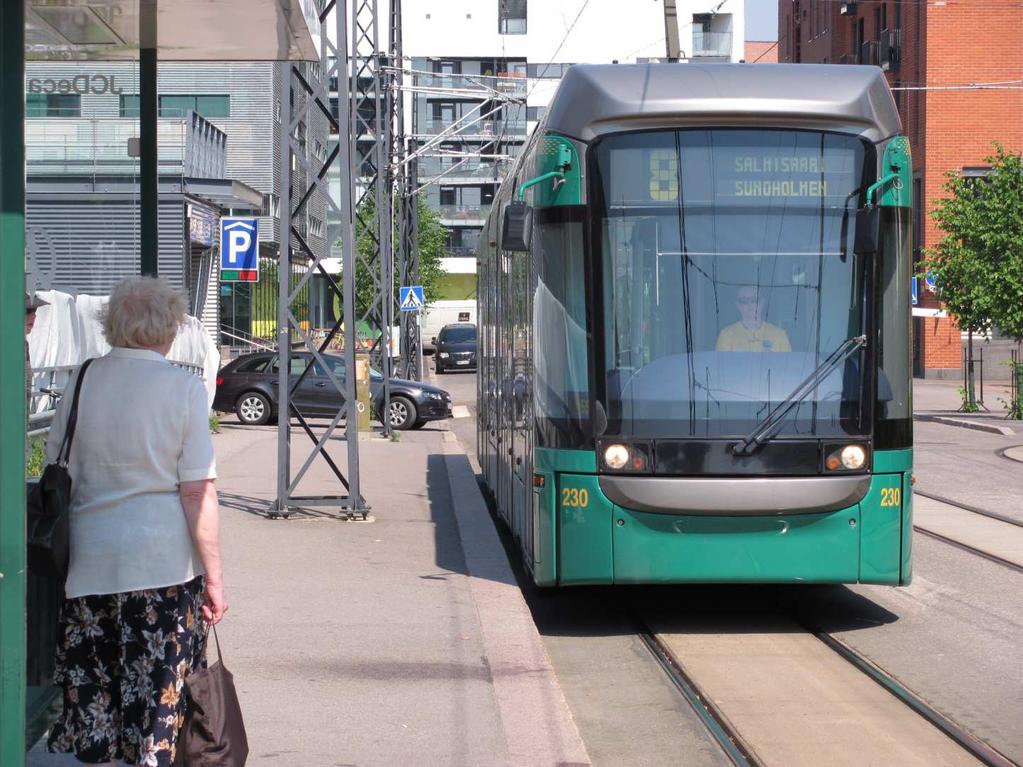
1 accessibility instruments in planning practice Spatial Network Analysis for Multi-Modal Transport Systems (SNAMUTS): Helsinki Prof Carey Curtis, Dr Jan Scheurer, Curtin University, Perth - RMIT University, Melbourne/Barcelona
2 POLICY CONTEXT Cities worldwide - interest in a more coordinated approach to growth management sustainable urban form sustainable transport outcomes. A popular planning strategy public transport oriented development (PTOD), more commonly referred to as transit oriented development (TOD) need to consider both land use planning and transport planning in an integrated way, city planning framed around public transport address both the form and structure of the city, and quality of the public transport network to ensure each are mutually supportive and provide for improved accessibility. Curtis C (2015) Public Transport Orientated Development and Network Effects, in An International Handbook on Transport and Development, Edward Elgar, Co-Editors: Hickman, R., Bonilla, D., Givoni M., Banister D. 2


3 Context - Land use transport integration in Australian cities clear policy intentions in Metropolitan Plans for LUTI but selective implementation resulted in low density and dispersed form not only are cities spread out but land use activity is scattered.. a myriad of centres Source: C.Curtis, 2001 possibility of supplying a high frequency public transport system to serve these centres a challenge.
: Perth 2000 15% 5 80% Perth 2029 26% 13% 61%")

4 mid 1990 s new approach emerging policy context Mode Share Target by trips (1995): Perth % 5 80% Perth % 13% 61% Non-motorised modes Public transport Private vehicle...targets imply that public transport patronage needed to grow four-fold between 2000 and


5 Network City spatial framework did not determine which centres should perform which role within the goal of sustainable accessibility
6 These new policy goals demanded a multi-dimensional perspective Which Activity Centres and Corridors can best be intensified? Which Centres should perform a regional role and which a local roles? Where should public transport investment (infrastructure, service improvement) go? What effect would changes to transport accessibility by car have (through fuel price increases, parking strategies etc)? Centres must not be considered in isolation from each other the way in which they are networked forms an important component shifting from a case by case perspective to a strategic perspective Answers to these questions provide a robust basis for decisions about the future metropolitan structure.
7 Evolution of our accessibility work 1. ARC Project on TOD examined how accessibility changed following opening of a new 72km railway 2. Research Consultancy Australian State Governments: a) Metropolitan growth choices b) Public transport investment 3. ARC 3 year project - Continue the development of the interactive accessibility tool by examining 25 Cities in Australia, Europe, N. America & Asia: SNAMUTS as a benchmarking tool SNAMUTS methodology and robustness in a range of city types 1. EU COST Action TU1002: Accessibility Tools in Planning Practice: 22 European Countries & Australia Local (National) Workshops USE & USEABILITY
8 spatial network analysis for multimodal urban transport systems (SNAMUTS) Purpose: To assess and quantify how transport networks, in terms of geographical configuration and service levels, perform in their urban context (distribution of land use activities). SNAMUTS is a supply-side tool: it does not provide predictions about usage or capacity levels. Rather it asks: What is the role of the public transport system in facilitating movement and activity across a city region?


9 network connectivity Create a network effect by local optimisation to routes, good interchange facilities, high and standardised service frequencies, timetable coordination and the presence of orbital/crosssuburban routes to maximise market penetration for public transport. Map Sources:

10 public transport from a user perspective How can we measure distance (or travel impediment) in ways that come close to user perceptions and motivations? Public transport users are only marginally interested in geographical distance: the main factors of travel disutility are travel time, and the ubiquity of travel opportunities (service frequency)
, 30 min weekdays and 7 day service (rail) Identifying activity nodes: SNAMUTS matrix of activity nodes derived from activity centre hierarchy in strategic")
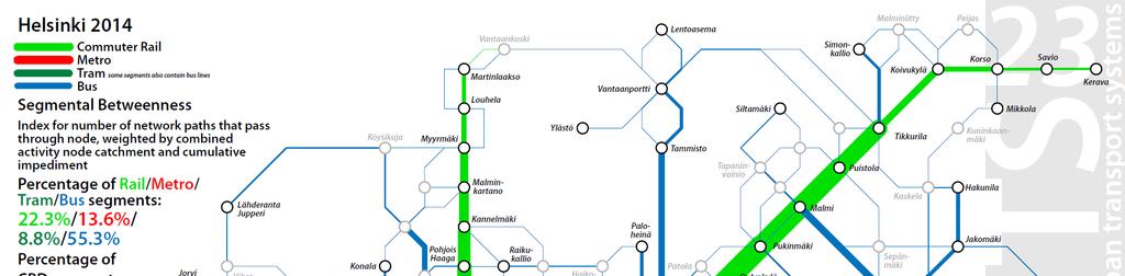
11 compiling a base network Spatial separation or impediment measure: Travel time divided by service frequency (d=4t/ f) Minimum service standard (SNAMUTS 23): 20 min frequency during the weekday interpeak, 30 min on Sat/Sun (buses, trams), 30 min weekdays and 7 day service (rail) Identifying activity nodes: SNAMUTS matrix of activity nodes derived from activity centre hierarchy in strategic planning documents and from field observation. Helsinki has 102 activity nodes with an average catchment of approximately 14,000 residents and jobs.
12 8 key snamuts indicators Service Intensity Operational input Closeness Centrality Ease of movement Degree Centrality Transfer intensity Network Coverage Who gets access? 30-minute Contour Catchments Betweenness Centrality Presence and distribution of PT travel opportunities Network Resilience How future-proof is the public transport system? Nodal Connectivity Flexibility of movement in urban space
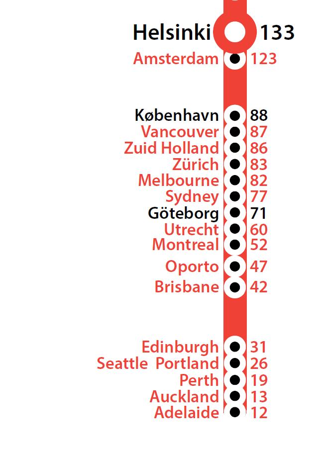
13 helsinki: service intensity Number of vehicles/train sets required in simultaneous operation for the minimum standard network (20 min weekdays, 30 min weekends for trams and buses, 30 minutes weekdays for trains) Trains Metros 9 20 total: per 100,000 pop (2014) Trams 52 Buses 355
14 service intensity: what does and what doesn t this index tell us? Operational efficiency: Networks dominated by slow modes (especially buses) tend to require greater operational input (in number of vehicles/drivers) than networks dominated by fast modes (especially light or heavy rail). Performance expectation: Does a higher outlay of operational resources consistently result in better public transport accessibility and network performance?


15 comparison of service intensity vehicles per 100,000 population
 Source: Porta, Crucitti and Latora")
16 understanding networks Networks have topological properties (how many degrees of separation from A to B) and metric properties (how many units of distance/impediment from A to B) Source: Porta, Crucitti and Latora 2006


17 closeness centrality What is the ease of movement across the network? [smaller values indicate better accessibility performance]
18 closeness centrality: what does and what doesn t this index tell us? Ease of movement: Closeness scores are a spatial separation measure for the activity centre network. They are inflated by (1) dispersed settlement patterns, (2) detours forced by geographical barriers or missing links, (3) slow travel speeds, (4) low service frequencies, or a combination of several of the above. Network size: Larger networks with a greater number of activity centres will generally produce higher (poorer) average closeness centrality scores than smaller ones.


19 comparison of closeness centrality average per network
20 degree centrality What is the transfer intensity of the network? [smaller values indicate better accessibility performance]
21 degree centrality: what does and what doesn t this index tell us? Network organisation: Is the public transport network organised around a modal hierarchy with lower-capacity modes acting as feeders and distributors to higher-capacity nodes (greater transfer intensity)? Or do the networks of modes with different performance coexist (compete?) in spatial terms (lower transfer intensity)?


22 comparison of degree centrality average per network
23 contour catchments How many residents and jobs can you access within 30 minutes from each activity node?
24 network coverage and contour catchments: what do and what don t these indexes tell us? Network coverage describes the quantity of people with access to public transport, while the contour catchment measure expands this with a qualitative message (how many people can you access within 30 minutes?) The contour catchment assesses how successfully public transport endowment translates into the practical penetration of the settlement area with useful public transport journey paths. Ideally, a city should achieve 100% network coverage and an average contour catchment of 50%.
 and average contour")

25 comparison of network coverage (left) and average contour catchments (right) percentage of metropolitan residents and jobs
26 betweenness centrality How are travel opportunities distributed across the network?
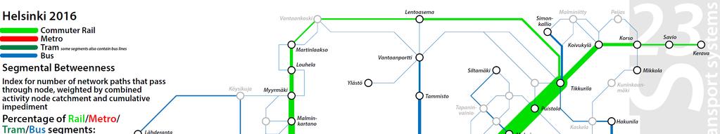
27 nodal and segmental betweenness
28 betweenness centrality: what does and what doesn t this index tell us? Public transport movement energy : Betweenness centrality attempts to quantify the presence of public transport opportunities in each centre, and across the metropolitan area, as well as visualise how this presence flows across the network. Balanced and unbalanced nodes/places, stressed locations and routes: Betweenness can help identify pressures on network elements originating from either their land use or their transport function (or both in conjunction). Betweenness scores are not necessarily proportional to usage levels, but correlations with usage can point to under- or over-utilised potential for public transport movement.


29 comparison of global betweenness total per network per million residents and jobs
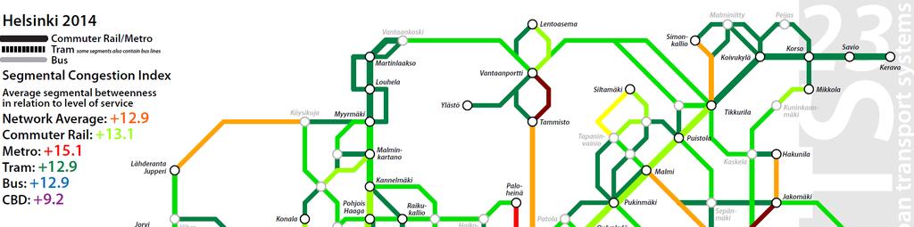
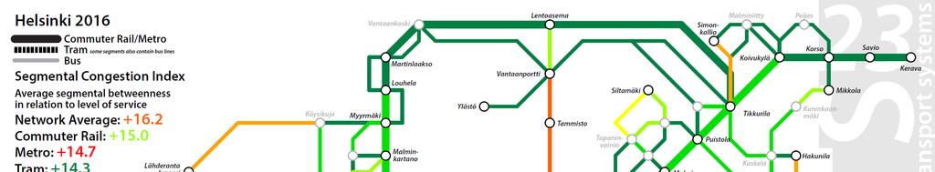
30 segmental betweenness and resilience
31 segmental betweenness and resilience
32 network resilience: what does and what doesn t this index tell us? A troubleshooting tool to pinpoint mismatches in public transport supply and (potential) demand (ie. demand as derived from urban form and network configuration) Includes a feedback loop, as isolated measures to improve service levels to relieve stress (ie. frequency upgrades) will also add to network stress through greater ease of movement. Responds most vigorously to more comprehensive solutions, such as network reconfigurations and mode upgrades.


33 comparison of network resilience average per network


34 nodal connectivity To what extent do network nodes function as hubs for movement?


35 comparison of nodal connectivity average per network


36 snamuts benchmarking composite index Good, average and poor public transport accessibility on a scale map
37 snamuts helsinki: preliminary findings (i) Helsinki has the second highest level of operational input relative to population among the non-asian SNAMUTS cities. This largesse translates into the highest concentration of public transport travel opportunities in the SNAMUTS sample, and the highest level of network coverage outside Asia. The average ease of movement in Helsinki s public transport network is by far the best of all cities in the sample. [Comparatively small city size supports this outcome.] Helsinki s network has mixed modal hierarchies: developed task-sharing between metro and bus and to some extent between tram and bus, but less so between train and bus.
38 snamuts helsinki: preliminary findings (ii) Small size, compact city shape, good travel speeds and a multidirectional network that effectively bridges geographical barriers (water bodies) combine to deliver the largest average 30-minute contour catchment relative to population of all 26 SNAMUTS cities. Helsinki s network remains relatively bus-reliant (though this is set to decrease with the opening of Länsimetro) and shows some weaknesses in resilience on critical bus links, suggesting unexhausted potential for ridership perhaps this is due to a generous and highly competitive road system particularly in the middle and outer suburbs?

39 so what happens once ring rail and länsimetro have been added to the network?
40 the effects of ring rail and länsimetro (stage 1) Service intensity: slight decline from 36.6 to 35.4 vehicles/trains per 100,000 inh Closeness centrality: average decline from 28.3 to 30.3 Degree centrality: average constant at 0.94 Network coverage and average contour catchments increase slightly (83.0 to 83.3%/40.6% to 41.1%) Betweenness centrality: global betweenness declines slightly from 639 to 630. Heavy rail share (segmental betweenness) increases from 35.9% to 50.2%. CBD significance declines slightly from 22.8% to 21.5% Network resilience: average increase from to Nodal connectivity: average increase from 133 to 139


41 efficiency change Where does accessibility/ease of movement increase or decline as the network changes?


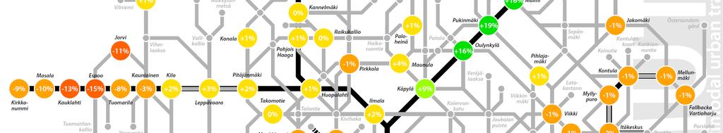
42 segmental betweenness 2014


43 segmental betweenness 2016


44 network resilience 2014


45 network resilience 2016
46 accessibility instruments in planning practice Spatial Network Analysis for Multi-Modal Transport Systems (SNAMUTS): Helsinki
Accessibility Instruments in Planning Practice Spatial Network Analysis for Multi-Modal Transport Systems (SNAMUTS): Adelaide
: Adelaide") Accessibility Instruments in Planning Practice Spatial Network Analysis for Multi-Modal Transport Systems (SNAMUTS): Adelaide Prof Carey Curtis, Dr Jan Scheurer, Roger Mellor, Oscar Thomson Curtin University,
Accessibility Instruments in Planning Practice Spatial Network Analysis for Multi-Modal Transport Systems (SNAMUTS): Adelaide Prof Carey Curtis, Dr Jan Scheurer, Roger Mellor, Oscar Thomson Curtin University,
Accessibility as an Instrument in Planning Practice. Derek Halden DHC 2 Dean Path, Edinburgh EH4 3BA
 Accessibility as an Instrument in Planning Practice Derek Halden DHC 2 Dean Path, Edinburgh EH4 3BA derek.halden@dhc1.co.uk www.dhc1.co.uk Theory to practice a starting point Shared goals for access to
Benchmarking Accessibility and Public Transport Network Performance in Copenhagen and Perth
 Institute of Transport Studies, Monash University World Transit Research World Transit Research 1-1-2010 Benchmarking Accessibility and Public Transport Network Performance in Copenhagen and Perth Jan
Benchmarking public transport accessibility in Australasian cities
 Curtis and Scheurer 35 th Australasian Transport Research Forum 2012 Benchmarking public transport accessibility in Australasian cities Carey Curtis (Curtin University) Jan Scheurer (RMIT University/Curtin
Developing harmonised indicators on urban public transport in Europe
 Developing harmonised indicators on urban public transport in Europe Hugo Poelman European Commission DG Regional and Urban GIS team Regional May 2015 context EU Cohesion European Regional Development
City sustainability: a transport perspective a journey continues
 Sustainable Development, Vol. 2 833 City sustainability: a transport perspective a journey continues K. Doust1,2, C. Wang1 & T. Doust2 1 Research Centre for Integrated Transport Innovation (rciti), University
Effects of a non-motorized transport infrastructure development in the Bucharest metropolitan area
 The Sustainable City IV: Urban Regeneration and Sustainability 589 Effects of a non-motorized transport infrastructure development in the Bucharest metropolitan area M. Popa, S. Raicu, D. Costescu & F.
Foreword. Vision and Strategy
 GREATER MANCHESTER SPATIAL FRAMEWORK Friends of Walkden Station Consultation Response January 2017 Foreword Friends of Walkden Station are a group of dedicated volunteers seeking to raise the status and
The 3V Approach. Transforming the Urban Space through Transit Oriented Development. Gerald Ollivier Transport Cluster Leader World Bank Hub Singapore
 Transforming the Urban Space through Transit Oriented Development The 3V Approach Gerald Ollivier Transport Cluster Leader World Bank Hub Singapore MDTF on Sustainable Urbanization The China-World Bank
Performance measures for public transport accessibility: Learning from international practice
 The Journal of Transport and Land Use http://jtlu.org Vol. 10 No. 1 [2017] pp. 93 118 Performance measures for public transport accessibility: Learning from international practice Carey Curtis Curtin University
Transport Planning in Large Scale Housing Developments. David Knight
 Transport Planning in Large Scale Housing Developments David Knight Large Scale Housing Developments No longer creating great urban spaces in the UK (Hall 2014) Transport Planning Transport planning processes
How is public transport performing in Australia
 How is public transport performing in Australia CILTA Moving People Thursday 17 March 2011 Professor Corinne Mulley Institute of Transport and Logistics Studies Outline Measuring performance Australia
Forecasts from the Strategy Planning Model
 Forecasts from the Strategy Planning Model Appendix A A12.1 As reported in Chapter 4, we used the Greater Manchester Strategy Planning Model (SPM) to test our long-term transport strategy. A12.2 The origins
Assessing spatial distribution and variability of destinations in inner-city Sydney from travel diary and smartphone location data
 Assessing spatial distribution and variability of destinations in inner-city Sydney from travel diary and smartphone location data Richard B. Ellison 1, Adrian B. Ellison 1 and Stephen P. Greaves 1 1 Institute
Transit-Oriented Development. Christoffer Weckström
 Transit-Oriented Development Christoffer Weckström 31.10.2017 Outline Context of Transit-oriented Development Elements of Transit-oriented Development A short history of land use and transit integration
transportation research in policy making for addressing mobility problems, infrastructure and functionality issues in urban areas. This study explored
 ABSTRACT: Demand supply system are the three core clusters of transportation research in policy making for addressing mobility problems, infrastructure and functionality issues in urban areas. This study
Subject: Note on spatial issues in Urban South Africa From: Alain Bertaud Date: Oct 7, A. Spatial issues
 Page 1 of 6 Subject: Note on spatial issues in Urban South Africa From: Alain Bertaud Date: Oct 7, 2009 A. Spatial issues 1. Spatial issues and the South African economy Spatial concentration of economic
Measuring connectivity in London
 Measuring connectivity in London OECD, Paris 30 th October 2017 Simon Cooper TfL City Planning 1 Overview TfL Connectivity measures in TfL PTALs Travel time mapping Catchment analysis WebCAT Current and
Public Transport and Land Use Integration in Melbourne and Hamburg: Can Comparative Network Performance Provide a Sense of Future Direction?
 Public Transport and Land Use Integration in Melbourne and Hamburg: Can Comparative Network Performance Provide a Sense of Future Direction? Public Transport and Land Use Integration in Melbourne and Hamburg:
Note on Transportation and Urban Spatial Structure
 Note on Transportation and Urban Spatial Structure 1 By Alain Bertaud, Washington, ABCDE conference, April 2002 Email: duatreb@msn.com Web site: http://alain-bertaud.com/ http://alainbertaud.com/ The physical
Travel behavior of low-income residents: Studying two contrasting locations in the city of Chennai, India
 Travel behavior of low-income residents: Studying two contrasting locations in the city of Chennai, India Sumeeta Srinivasan Peter Rogers TRB Annual Meet, Washington D.C. January 2003 Environmental Systems,
The National Spatial Strategy
 Purpose of this Consultation Paper This paper seeks the views of a wide range of bodies, interests and members of the public on the issues which the National Spatial Strategy should address. These views
Land Use in the context of sustainable, smart and inclusive growth
 Land Use in the context of sustainable, smart and inclusive growth François Salgé Ministry of sustainable development France facilitator EUROGI vice president AFIGéO board member 1 Introduction e-content+
True Smart and Green City? 8th Conference of the International Forum on Urbanism
 ,, doi:10.3390/ifou-. True Smart and Green City? 8th Conference of the International Forum on Urbanism Conference Proceedings Paper Comparable Measures of Accessibility to Public Transport by the General
Development of modal split modeling for Chennai
 IJMTES International Journal of Modern Trends in Engineering and Science ISSN: 8- Development of modal split modeling for Chennai Mr.S.Loganayagan Dr.G.Umadevi (Department of Civil Engineering, Bannari
Travel Related Urban Zones in Finland
 Travel Related Urban Zones in Finland Theory of Urban Fabrics Seminar in Helsinki, SYKE, 24.10.2013 Mika Ristimäki, Maija Tiitu, Ville Helminen, Panu Söderström, Kari Oinonen Finnish Environment Institute
Visitor Flows Model for Queensland a new approach
 Visitor Flows Model for Queensland a new approach Jason. van Paassen 1, Mark. Olsen 2 1 Parsons Brinckerhoff Australia Pty Ltd, Brisbane, QLD, Australia 2 Tourism Queensland, Brisbane, QLD, Australia 1
Financing Urban Transport. UNESCAP-SUTI Event
 Financing Urban Transport UNESCAP-SUTI Event October 2017 Urban Transport in Context 2 The spiky urban economy of global cities 3 Mass transit networks converge towards a characteristic structure with
Leveraging Urban Mobility Strategies to Improve Accessibility and Productivity of Cities
 Leveraging Urban Mobility Strategies to Improve Accessibility and Productivity of Cities Aiga Stokenberga World Bank GPSC African Regional Workshop May 15, 2018 Roadmap 1. Africa s urbanization and its
Analyzing the Market Share of Commuter Rail Stations using LEHD Data
 Analyzing the Market Share of Commuter Rail Stations using LEHD Data Using Census Data for Transportation Applications Conference, Irvine, CA October 26, 2011 1. What is the size of Metrolink s commute
How the science of cities can help European policy makers: new analysis and perspectives
 How the science of cities can help European policy makers: new analysis and perspectives By Lewis Dijkstra, PhD Deputy Head of the Economic Analysis Unit, DG Regional and European Commission Overview Data
CORRIDORS OF FREEDOM Access Management (Ability) Herman Pienaar: Director City Transformation and Spatial Planning
 Herman Pienaar: Director City Transformation and Spatial Planning") CORRIDORS OF FREEDOM Access Management (Ability) 2016 Herman Pienaar: Director City Transformation and Spatial Planning PLANNING DEVELOPMENT PROCESS RATHER THAN A PLAN CAPITAL INVESTMENT DEVELOPMENT FACILITATION
CORRIDORS OF FREEDOM Access Management (Ability) 2016 Herman Pienaar: Director City Transformation and Spatial Planning PLANNING DEVELOPMENT PROCESS RATHER THAN A PLAN CAPITAL INVESTMENT DEVELOPMENT FACILITATION
Beyond Mobility - Understanding and comparing urban accessibility in European Cities. Guy Hitchcock, Knowledge Leader
 Beyond Mobility - Understanding and comparing urban accessibility in European Cities Guy Hitchcock, Knowledge Leader 2 Study on improving the understanding of urban accessibility and road congestion in
Decentralisation and its efficiency implications in suburban public transport
 Decentralisation and its efficiency implications in suburban public transport Daniel Hörcher 1, Woubit Seifu 2, Bruno De Borger 2, and Daniel J. Graham 1 1 Imperial College London. South Kensington Campus,
Mapping cities by transit riders trajectories: The case of Brisbane, Australia. Citation Environment and Planning A, 2017, v. 49 n. 8, p.
 Title Mapping cities by transit riders trajectories: The case of Brisbane, Australia Author(s) Zhou, J; Corcoran, J; Borsellino, R Citation Environment and Planning A, 2017, v. 49 n. 8, p. 1707-1709 Issued
European spatial policy and regionalised approaches
 Findings of the ESPON 2006 Programme COMMIN Final Conference 26-27 April 2007 European spatial policy and regionalised approaches by Dr. Kai BöhmeB ! Territory matters Structure of presentation! Territorial
Land use/transport integration: the vital role of our forgotten middle suburbs. March 2016
 Land use/transport integration: the vital role of our forgotten middle suburbs March 2016 Presented by Adjunct Professor John Stanley Institute of Transport and Logistics Studies (ITLS) The University
City of Johannesburg Department: Development Planning And Urban Management Development Planning and Facilitation
 City of Johannesburg Department: Development Planning And Urban Management Development Planning and Facilitation Marlboro Urban Development Framework: Discussion Document July 2007 1 Prepared for Department
On transport and other infrastructure knitting regions together
 Published as: WITLOX, F. (2011) On transport and other infrastructure knitting regions together. In: A. VAN RENTERGHEM (Ed.) Polycentric Regions facing Global Challenges. A Role for Strategic Spatial Planning
Towards a Co-ordinated Planning of Infrastructure and Urbanization
 Towards a Co-ordinated Planning of Infrastructure and Urbanization Problems, Solutions and Conditions for Success in the current Dutch Policy and Planning Practice Content of presentation Content of presentation
Poland, European Territory, ESPON Programme Warsaw, 2 July 2007 STRATEGY OF THE ESPON 2013 PROGRAMME
 Poland, European Territory, ESPON Programme 2007-2013 Warsaw, 2 July 2007 STRATEGY OF THE ESPON 2013 PROGRAMME Territory matters Regional diversity as asset Territorial potentials increasing in importance
THE ROLE OF REGIONAL SPATIAL PLANNING IN SUPPORTING LONG-TERM ECONOMIC GROWTH IN NORTHERN IRELAND
 THE ROLE OF REGIONAL SPATIAL PLANNING IN SUPPORTING LONG-TERM ECONOMIC GROWTH IN NORTHERN IRELAND Jenny Pyper Director 6 th Annual ICLRD Conference 20 January 2011 PURPOSE OF REGIONAL PLANNING Framework
Thilo Becker
 Friedrich List Faculty of Transport and Traffic Science, Chair of Transport Ecology CAN THE CONCEPT OF ENVIRONMENTAL JUSTICE IN TRANSPORT BE TRANSFERRED TO CITIES OF THE SOUTH? A CASE STUDY OF NAIROBI
Measurement of the Urban-Housing Deficit:
 Measurement of the Urban-Housing Deficit: Strategies, tools and sources of information The International Network for Urban and Regional Statistics Standing Committee of the International Association for
Data driven approaches to Urban Planning Experience from Derry/Londonderry
 Data driven approaches to Urban Planning Experience from Derry/Londonderry Anna Rose RTPI Belfast 11 th of September 1 June 26 07:47AM 2 The value of the City The space of the city is a theatre: playing
New Partners for Smart Growth: Building Safe, Healthy, and Livable Communities Mayor Jay Williams, Youngstown OH
 New Partners for Smart Growth: Building Safe, Healthy, and Livable Communities Mayor Jay Williams, Youngstown OH The City of Youngstown Youngstown State University Urban Strategies Inc. Youngstown needed
Recovery Renewal Rebuilding
 Recovery Renewal Rebuilding Federal Reserve Foreclosure Series Washington, D.C. October 20, 2008 Mayor Jay Williams, Youngstown OH The City of Youngstown Youngstown State University Urban Strategies Inc.
Figure 8.2a Variation of suburban character, transit access and pedestrian accessibility by TAZ label in the study area
 Figure 8.2a Variation of suburban character, transit access and pedestrian accessibility by TAZ label in the study area Figure 8.2b Variation of suburban character, commercial residential balance and mix
GEOGRAPHY YEAR 11 ATAR 2019 COURSE OUTLINE
 GEOGRAPHY YEAR 11 ATAR 2019 COURSE OUTLINE Geography ATAR Year 11 Semester 1 Unit 1 Natural and ecological hazards 1 3 Geographical skills Mapping skills identify and interpret a variety of topographic
The ESPON Programme. Goals Main Results Future
 The ESPON Programme Goals Main Results Future Structure 1. Goals Objectives and expectations Participation, organisation and networking Themes addressed in the applied research undertaken in ESPON projects
TOWARDS STRATEGIC SPATIAL PLANNING IN JAMAICA: THE NATIONAL SPATIAL PLAN
 TOWARDS STRATEGIC SPATIAL PLANNING IN JAMAICA: THE NATIONAL SPATIAL PLAN JIEP 5th Biennial Conference on the Environment: Balancing National Development and Environmental Protection June 6, 2011 Jamaica
The sustainable location of low-income housing development in South African urban areas
 Sustainable Development and Planning II, Vol. 2 1165 The sustainable location of low-income housing development in South African urban areas S. Biermann CSIR Building and Construction Technology Abstract
Regional Growth Strategy Work Session Growth Management Policy Board
 Regional Growth Strategy Work Session Growth Management Policy Board September 6, 2018 1 Overview Recap June GMPB work session Objectives and outcomes Regional geographies Growth scenarios Breakout Discussion:
GIS Analysis of Crenshaw/LAX Line
 PDD 631 Geographic Information Systems for Public Policy, Planning & Development GIS Analysis of Crenshaw/LAX Line Biying Zhao 6679361256 Professor Barry Waite and Bonnie Shrewsbury May 12 th, 2015 Introduction
CIV3703 Transport Engineering. Module 2 Transport Modelling
 CIV3703 Transport Engineering Module Transport Modelling Objectives Upon successful completion of this module you should be able to: carry out trip generation calculations using linear regression and category
National Spatial Development Perspective (NSDP) Policy Coordination and Advisory Service
 Policy Coordination and Advisory Service") National Spatial Development Perspective (NSDP) Policy Coordination and Advisory Service 1 BACKGROUND The advances made in the First Decade by far supersede the weaknesses. Yet, if all indicators were
National Spatial Development Perspective (NSDP) Policy Coordination and Advisory Service 1 BACKGROUND The advances made in the First Decade by far supersede the weaknesses. Yet, if all indicators were
Designing TOD precincts: accessibility and travel patterns. Doina Olaru 1 Business School, University of Western Australia, Australia.
 EJTIR Issue 15(1), 2015 pp. 6-26 ISSN: 1567-7141 tlo.tbm.tudelft.nl/ejtir Designing TOD precincts: accessibility and travel patterns Doina Olaru 1 Business School, University of Western Australia, Australia.
BROOKINGS May
 Appendix 1. Technical Methodology This study combines detailed data on transit systems, demographics, and employment to determine the accessibility of jobs via transit within and across the country s 100
I. M. Schoeman North West University, South Africa. Abstract
 Urban Transport XX 607 Land use and transportation integration within the greater area of the North West University (Potchefstroom Campus), South Africa: problems, prospects and solutions I. M. Schoeman
High speed network in Hauts-de-France Region. Värnamo, 17 th May 2018
 High speed network in Hauts-de-France Region Värnamo, 17 th May 2018 Hauts-de-France at the crossroads of the North-West Europe High speed train approach in France In the 1980s: will to link the main cities
Managing Growth: Integrating Land Use & Transportation Planning
 Managing Growth: Integrating Land Use & Transportation Planning Metro Vancouver Sustainability Community Breakfast Andrew Curran Manager, Strategy June 12, 2013 2 Integrating Land Use & Transportation
Behavioural Analysis of Out Going Trip Makers of Sabarkantha Region, Gujarat, India
 Behavioural Analysis of Out Going Trip Makers of Sabarkantha Region, Gujarat, India C. P. Prajapati M.E.Student Civil Engineering Department Tatva Institute of Technological Studies Modasa, Gujarat, India
Alluvium Consulting Australia Senior integrated water management specialist Position Description March 2018
 Alluvium Consulting Australia Senior integrated water management specialist Position Description March 2018 Overview of Alluvium We are an employee-owned consulting firm founded in 2006 to provide advice
Mapping Accessibility Over Time
 Journal of Maps, 2006, 76-87 Mapping Accessibility Over Time AHMED EL-GENEIDY and DAVID LEVINSON University of Minnesota, 500 Pillsbury Drive S.E., Minneapolis, MN 55455, USA; geneidy@umn.edu (Received
Role of SF-MST. A summary of SF-MST
 A summary of SF-MST UNWTO Committee on Statistics and TSA Madrid, 27 & 28 February 2018 Carl Obst, IDEEA Group Consultant to UNWTO Role of SF-MST Respond to the significant demand for robust measures of
A Simplified Travel Demand Modeling Framework: in the Context of a Developing Country City
 A Simplified Travel Demand Modeling Framework: in the Context of a Developing Country City Samiul Hasan Ph.D. student, Department of Civil and Environmental Engineering, Massachusetts Institute of Technology,
Metrolinx Transit Accessibility/Connectivity Toolkit
 Metrolinx Transit Accessibility/Connectivity Toolkit Christopher Livett, MSc Transportation Planning Analyst Research and Planning Analytics Tweet about this presentation #TransitGIS OUTLINE 1. Who is
STILLORGAN QBC LEVEL OF SERVICE ANALYSIS
 4-5th September, STILLORGAN QBC LEVEL OF SERVICE ANALYSIS Mr David O Connor Lecturer Dublin Institute of Technology Mr Philip Kavanagh Graduate Planner Dublin Institute of Technology Abstract Previous
ACCESSIBILITY TO SERVICES IN REGIONS AND CITIES: MEASURES AND POLICIES NOTE FOR THE WPTI WORKSHOP, 18 JUNE 2013
 ACCESSIBILITY TO SERVICES IN REGIONS AND CITIES: MEASURES AND POLICIES NOTE FOR THE WPTI WORKSHOP, 18 JUNE 2013 1. Significant differences in the access to basic and advanced services, such as transport,
MULTIPLE CHOICE. Choose the one alternative that best completes the statement or answers the question.
 AP Test 13 Review Name MULTIPLE CHOICE. Choose the one alternative that best completes the statement or answers the question. 1) Compared to the United States, poor families in European cities are more
Let s make integrated land-use and transport modelling useful
 Let s make integrated land-use and transport modelling useful Prof. Dr.-Ing. Gebhard Wulfhorst Chair of Urban Structure and Transport Planning Technical University of Munich (TUM) Symposium for the Integration
Implementation Status & Results Vietnam Danang Sustainable City Development Project (SCDP) (P123384)
 (P123384)") Public Disclosure Authorized Public Disclosure Authorized The World Bank Implementation Status & Results Vietnam Danang Sustainable City Development Project (SCDP) (P123384) Operation Name: Danang Sustainable
Public Disclosure Authorized Public Disclosure Authorized The World Bank Implementation Status & Results Vietnam Danang Sustainable City Development Project (SCDP) (P123384) Operation Name: Danang Sustainable
Key Indicators for Territorial Cohesion & Spatial Planning Stakeholder Workshop - Project Update. 13 th December 2012 San Sebastián, Basque Country
 Key Indicators for Territorial Cohesion & Spatial Planning Stakeholder Workshop - Project Update 13 th December 2012 San Sebastián, Basque Country Key Aims Explore the use of territorial data in developing
Lecture 19: Common property resources
 Lecture 19: Common property resources Economics 336 Economics 336 (Toronto) Lecture 19: Common property resources 1 / 19 Introduction Common property resource: A resource for which no agent has full property
Shall we Dense?: Policy Potentials. Summary. Simon McPherson Director SJB Urban Australia au
 Shall we dense? Shall we Dense?: Policy Potentials Simon McPherson Director SJB Urban Australia smcpherson@sjb.com. au Adam Haddow Director SJB Architects Australia ahaddow@sjb.com.au Summary This paper
IOP Conference Series: Earth and Environmental Science. Related content OPEN ACCESS
 IOP Conference Series: Earth and Environmental Science OPEN ACCESS Using GIS to integrate the analysis of land-use, transportation, and the environment for managing urban growth based on transit oriented
Why care about metropolitan and regional perspectives?
 Metropolitan challenges and solutions Why care about metropolitan and regional perspectives? Irma Karjalainen, Director, Helsinki Region Environmental Services Authority HSY, LUMAT Conference, 25 September
Simulating Mobility in Cities: A System Dynamics Approach to Explore Feedback Structures in Transportation Modelling
 Simulating Mobility in Cities: A System Dynamics Approach to Explore Feedback Structures in Transportation Modelling Dipl.-Ing. Alexander Moser [amoser@student.tugraz.at] IVT Tagung 2013 - Kloster Kappel
Data Collection. Lecture Notes in Transportation Systems Engineering. Prof. Tom V. Mathew. 1 Overview 1
 Data Collection Lecture Notes in Transportation Systems Engineering Prof. Tom V. Mathew Contents 1 Overview 1 2 Survey design 2 2.1 Information needed................................. 2 2.2 Study area.....................................
Kansainvälinen kesäseminaari: URBAANIA SAAVUTETTAVUUTTA ANALYSOIMASSA - Analysing urban accessibility -
 Kansainvälinen kesäseminaari: URBAANIA SAAVUTETTAVUUTTA ANALYSOIMASSA - Analysing urban accessibility - SNAMUTS MetropAccess 2 Carey Curtis Curti Universoty 3 Tilaisuuden ohjelma / program 9:00-9:30 MetropAccess-hankkeen
Third Cohesion report February 2004
 February 2004 A new partnership for cohesion Convergence, Competitiveness and Co-operation METREX meeting S. Sebastian, Luisa Sanches DG REGIO The 3rd CR structure 1. Analysis of situation and trends in
Dar es Salaam - Reality Check Workshop
 Dar es Salaam - Reality Check Workshop hosted by GIZ and Dar es Salaam City Council Introduction: Key Urban Characteristics of Dar es Salaam Challenges and Opportunities for Resilient Development in the
Transit Market Index. Validating Local Potential for Transit Ridership
 Transit Market Index Validating Local Potential for Transit Ridership Transit Market Areas Characteristics 2010 TPP Characterized by different levels of transit service. Core Areas, 1 & 2: A variety of
PURR: POTENTIAL OF RURAL REGIONS UK ESPON WORKSHOP Newcastle 23 rd November Neil Adams
 PURR: POTENTIAL OF RURAL REGIONS UK ESPON WORKSHOP Newcastle 23 rd November 2012 Neil Adams PURR: Potential of Rural Regions Introduction Context for the project A spectrum of knowledge Rural Potentials
Transit Time Shed Analyzing Accessibility to Employment and Services
 Transit Time Shed Analyzing Accessibility to Employment and Services presented by Ammar Naji, Liz Thompson and Abdulnaser Arafat Shimberg Center for Housing Studies at the University of Florida www.shimberg.ufl.edu
Policy Note 6. Measuring Unemployment by Location and Transport: StepSA s Access Envelope Technologies
 6 Measuring Unemployment by Location and Transport: StepSA s Access Envelope Technologies Introduction Increasing emphasis is coming onto spatial planning as government in South Africa moves to address
Spatial profile of three South African cities
 Spatial Outcomes Workshop South African Reserve Bank Conference Centre Pretoria September 29-30, 2009 Spatial profile of three South African cities by Alain Bertaud September 29 Email: duatreb@msn.com
OPTIMISING SETTLEMENT LOCATIONS: LAND-USE/TRANSPORT MODELLING IN CAPE TOWN
 OPTIMISING SETTLEMENT LOCATIONS: LAND-USE/TRANSPORT MODELLING IN CAPE TOWN Molai, L. and Vanderschuren, M.J.W.A. Civil Engineering, Faculty of Engineering and the Built Environment, University of Cape
Joint-accessibility Design (JAD) Thomas Straatemeier
 Thomas Straatemeier") Joint-accessibility Design (JAD) Thomas Straatemeier To cite this report: Thomas Straatemeier (2012) Joint-accessibility Design (JAD), in Angela Hull, Cecília Silva and Luca Bertolini (Eds.) Accessibility
Joint-accessibility Design (JAD) Thomas Straatemeier To cite this report: Thomas Straatemeier (2012) Joint-accessibility Design (JAD), in Angela Hull, Cecília Silva and Luca Bertolini (Eds.) Accessibility
REGIONAL SDI DEVELOPMENT
 REGIONAL SDI DEVELOPMENT Abbas Rajabifard 1 and Ian P. Williamson 2 1 Deputy Director and Senior Research Fellow Email: abbas.r@unimelb.edu.au 2 Director, Professor of Surveying and Land Information, Email:
CHAPTER 4: INVENTORY & LEVEL OF SERVICE ANALYSIS
 CHAPTER 4: INVENTORY & LEVEL OF SERVICE ANALYSIS A. Introduction This section provides an overview and analysis of the parks, recreation, trails, and open space system in Cary, North Carolina. First, the
A Note on Methods. ARC Project DP The Demand for Higher Density Housing in Sydney and Melbourne Working Paper 3. City Futures Research Centre
 A Note on Methods ARC Project DP0773388 The Demand for Higher Density Housing in Sydney and Melbourne Working Paper 3 City Futures Research Centre February 2009 A NOTE ON METHODS Dr Raymond Bunker, Mr
THE LEGACY OF DUBLIN S HOUSING BOOM AND THE IMPACT ON COMMUTING
 Proceedings ITRN2014 4-5th September, Caulfield and Ahern: The Legacy of Dublin s housing boom and the impact on commuting THE LEGACY OF DUBLIN S HOUSING BOOM AND THE IMPACT ON COMMUTING Brian Caulfield
The World Bank China Wuhan Second Urban Transport (P112838)
") EAST ASIA AND PACIFIC China Transport Global Practice IBRD/IDA Specific Investment Loan FY 2010 Seq No: 7 ARCHIVED on 28-Jun-2015 ISR18605 Implementing Agencies: Wuhan Urban Construction Utilization of
EAST ASIA AND PACIFIC China Transport Global Practice IBRD/IDA Specific Investment Loan FY 2010 Seq No: 7 ARCHIVED on 28-Jun-2015 ISR18605 Implementing Agencies: Wuhan Urban Construction Utilization of
The Project s Development Objective (PDO) is to promote environmentally sustainable urban transport in India and to improve the usage of
 is to promote environmentally sustainable urban transport in India and to improve the usage of") Public Disclosure Authorized SOUTH ASIA India Transport & ICT Global Practice IBRD/IDA Specific Investment Loan FY 2010 Seq No: 18 ARCHIVED on 01-Mar-2017 ISR26438 Implementing Agencies: Public Disclosure
Public Disclosure Authorized SOUTH ASIA India Transport & ICT Global Practice IBRD/IDA Specific Investment Loan FY 2010 Seq No: 18 ARCHIVED on 01-Mar-2017 ISR26438 Implementing Agencies: Public Disclosure
South Bristol Link Forecasting Report
 South Bristol Link April 2013 Atkins 5098941 AVTM Forecasting v2 PI (Draft 120331) Draft 31 March 2012 1 Notice This document and its contents have been prepared and are intended solely for West of England
I-1. The slope of the bid-price function, P{u}, is - t / H. Use Equation (35) to derive general
 to derive general") ECN 741, Professor Yinger Exercises Part I. Bid Functions and Density Functions I-1. The slope of the bid-price function, P{u}, is - t / H. Use Equation (35) to derive general expression for the slope
ECN 741, Professor Yinger Exercises Part I. Bid Functions and Density Functions I-1. The slope of the bid-price function, P{u}, is - t / H. Use Equation (35) to derive general expression for the slope
Typical information required from the data collection can be grouped into four categories, enumerated as below.
 Chapter 6 Data Collection 6.1 Overview The four-stage modeling, an important tool for forecasting future demand and performance of a transportation system, was developed for evaluating large-scale infrastructure
Thoughts toward autonomous land development. Introduction
 Thoughts toward autonomous land development Spatial Transformation of Regular grid Irrigation Frameworks Bangkok and Cairo A Work in Progress Information based on student workshop June 2009 and earlier