Importance of Open Geospatial Science. Suchith Anand
|
|
|
- Edgar Robertson
- 6 years ago
- Views:
Transcription


1 Importance of Open Geospatial Science Suchith Anand


2 Oxera 2013
3 Very few universities/educational institutions in developing/poor countries currently are able to teach Geospatial Science courses High cost of software Lack of skilled staff Lack of freely available training materials
4

 and")


5 ICA- OSGeo MoU Prof. Georg Gartner (ICA President) and Arnulf Christl (OSGeo President) shake hands after signing the MoU at Intergeo 2011 in Germany (Sep 2011)


6 ICA is the world authoritative body for cartography and Geographic Information Science
7 Open Source Geospatial Foundation (OSGeo)

8 Open Source Geospatial Foundation (OSGeo) established in Feb 2006 OSGeo is the leader of Open Source Geospatial and high impact community OS Geo Product development statistics 2008


9 Making resources including software and data openly available offers an opportunity for knowledge to be shared widely so as to increase learning opportunities. Example Collaborating with educational initiatives like gvsig Batoví For details contact: Sergio Acosta y Lara sacosta@dntopografia.gub.uy Alvaro Anguix aanguix@gvsig.com


10 For details contact: Sergio Acosta y Lara sacosta@dntopografia.gub.uy Alvaro Anguix aanguix@gvsig.com
11 Aim s of I CA- OSGeo Labs I nitiative Establishing research and training opportunities in open source GIS Build teaching and research infrastructure worldwide Provide worldwide learning platform


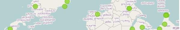
12 Geo for All Education Initiative ICA-OSGeo MoU in Sep 2011 Over 75 labs established worldwide as of today Distribution ICA-OSGeo labs established in Europe Image : (6 months back) Will be establishing over 100 labs in universities worldwide by Sep 2014 North America 13 labs Europe 31 labs South America 9 labs Africa 4 labs Asia 15 labs Australia - 1 lab
13 Why having a framework for Open Geospatial Science important for the future? Strategic level Research Teaching Attracting research funding /sustainability Social Responsibility


14 Big Picture - Open GIS Geospatial is key for innovation in GIS Research Geospatial Standards (for ex. OGC spec.) Ability for showing the operation of general laws is fundamental for scientific research Open Data Maturity of open source software (for ex. OSGeo stack)


15 Government level initiatives - Key for interoperability and lower costs
16 Open Data key for innovation and transparency


17 Research importance - Increasing software quality

18 Increasing innovation Internet backbone is powered by OSS Since April 1996 Apache has been the most popular HTTP server software in use. As of May 2011 Apache was estimated to serve 63% of all websites and 66% of the million busiest "May 2011 Web Server Survey". Netcraft. May 17,
19 Reuse big enabler for Research and Teaching
20 Reuse big enabler for Research and Teaching


21 Aim 1 Establishing open Establishing open source GIS research and training opportunities
22
23 Strategic Training Programs


")

24 Aim 2 Scale up research and teaching Open Geospatial Labs are being established worldwide to scale up research and teaching in this theme globally (ICA-OSGeo MoU) University of Pretoria, South Africa


25 Build teaching and research infrastructure worldwide Open Source Geospatial Lab founding meeting at UoN June 2010
26 University of Southampton OSGL "applied" research and Spatial Data Infrastructure delivery of real world Open Source geospatial and data management applications for research infrastructure, government and industry, e.g.: - Channel Coastal Observatory - MEDIN UK Marine metadata portal development and dissemination of software: Web OpenLayers, Leaflet, OSM, PostGIS, MapServer Quantum (custom plugins) delivery of specialist CPD and GIS training Quantum, etc. on.ac.uk osgl@geodat a.sot on.ac.uk


27 Research topics & collaborators Current projects Activities Disaster recovery monitoring Crowd-sourcing data quality assessment Unmanned Aerial Vehicle intercropping mapping system Remote sensing data fusion Remote sensing monitoring of large-scale construction projects Contact: Dr. Tuong-Thuy Vu School of Geography University of Nottingham, Malaysia campus tuongthuy.vu at nottingham.edu.my

, Gavin Fleming")
, Dr Serena Coetzee, Prof")
28 Launch in October 2012 ICA-OSGeo Lab at the University of Pretoria First in Africa Jeff McKenna (OSGeo President) visited us for the launch Back: Jeff McKenna (OSGeo President), Gavin Fleming (OSGeo South Africa) Front: Prof Elri Liebenberg (Former ICA vice-resident), Dr Serena Coetzee, Prof Hannes Rautenbach


29 Centre for Geoinformation Science Research focus groups Forensic geography Dr Peter Schmitz GISc Education and Training Sanet Eksteen Open source and data for geospatial / ICA-OSGeo Lab Dr Serena Coetzee Space geodesy, earth and atmospheric observation Dr Joel Botai Spatial data infrastructures Dr Serena Coetzee
30 Education and training Undergraduate BSc Geoinformatics Students from Geology, Zoology, Geography, Spatial planning, Computer Science, Practicals and assignments in PostGIS, QGIS, SAGA, Postgraduate BSc (Hons) Geoinformatics, BSc (Hons) Computer Science Spatial databases: practicals and assignments in PostGIS Internet GIS: practicals and assignments in OpenLayers, GeoServer


31 Education and training Continued Education at UP (CE at UP) Short courses, CPD points for registered professionals Introduction to Quantum GIS Spatial databases with PostGIS The Basics of GIS with QGIS NFP Alumni Course in Nambia, Windhoek, Oct/Nov 2013 With ITC and Polytechnic of Namibia The use of social media, crowdsourcing and webmapping to enable spatial web presence for the private sector in Southern Africa


32 The Geomatics Lab of Politecnico di Milano has been active in Como Campus since '95 and is now composed of two full professors, three assistant professors, one technician, 13 PhD and PostDoc Students, many Master Students... Laboratorio di Geom atica
33 Open Geospatial Labs are being established worldwide to scale up research and teaching in this theme globally (ICA-OSGeo MoU) North Carolina State University, USA
34 Free webinars
35 Example of an excellent Initiative led by Prof. Maria Brovelli and colleagues
36


37 Aim 3 - Providing Global learning platform and training opportunities
38 Geospatial I G The Research Data Alliance is supported by the European Commission, the U.S. Government and the Australian Government.
39
40 Open Science 2014 sessions planned at OSGIS We look forward to welcoming you to Nottingham.


41 Building an open source, open standards, open data research framework through OpenGIS Key advantages Scalable Interoperability Low costs No proprietary lockin Benefits wider community Represents the individual content creator on the World Wide Web
42 Building Open Geospatial Science - Geo for All
43 Acknowledgements To all colleagues in the Geo for All initiative
Introduction to GIS Suchith Anand
 Introduction to GIS Suchith Anand Introduction What is GIS? Spatial Data Models Fundamental GIS Map generalization Applied GIS Future Study links What is a Map? A map is a visual representation of an area
Building open source geospatial education at research universities: where we are and what is holding us back
 42 KEYNOTE TALKS Building open source geospatial education at research universities: where we are and what is holding us back Authors - Helena Mitasova, Department of Marine, Earth, and Atmospheric Sciences,
Boston, 16 August 2017 The UN Open GIS Initiative
 Boston, 16 August 2017 The UN Open GIS Initiative Kyoung-Soo Eom, UN Ricardo Arias, U.S. Africa Command (USAFRICOM) Maria Antonia Brovelli, OSGeo and Politecnico di Milano, Italy Ki-Joune Li, Pusan National
CARTOGRAPHY in a Web World
 CARTOGRAPHY in a Web World SENSE Research Cluster XIII meeting: Concepts and tools for spatial data visualization BAREND KÖBBEN kobben@itc.nl b.j.kobben@utwente.nl Agenda Short introduction to ITC and
From PCGIAP to UN GGIM AP: A Regional Perspective on GGIM
 Regional Committee of United Nations Global Geospatial Information Management for Asia and the Pacific (UN-GGIM-AP) Established by a United Nations Resolution From PCGIAP to UN GGIM AP: A Regional Perspective
Capacity Building on Geoportals. Geoinformatics Centre, AIT, Thailand
 Capacity Building on Geoportals in PIC Geoinformatics Centre, AIT, Thailand Content 1. About Geoinformatics Centre, AIT, Thailand 2. Introduction to Project and Our Contribution 3. Web Maps and Geonode
Evaluating Sustainability of the Georesources Observation System
 Evaluating Sustainability of the Georesources Observation System Michael Mente Federal Institute for Geosciences and Natural Resources Germany, Hannover GEOSS-CBC Meeting Athens April 27th 28th, 2009 GEOSS-CBC
CARTOGRAPHY in a Web World
 CARTOGRAPHY in a Web World Nationale GI Minor BAREND KÖBBEN b.j.kobben@utwente.nl Agenda Short introduction to ITC and me Cartography: communicating spatial data Changing GIS & Cartography technology:
Web 2.0, map production & publishing and geospatial information dissemenation
 Web 2.0, map production & publishing and geospatial information dissemenation Professor William Cartwright President, International Cartographic Association William Cartwright 18th UNRCC for Asia and the
Open Source Software Education in Texas
 Open Source Software Education in Texas PHILLIP DAVIS / RICHARD SMITH GEOACADEMY The Challenge for Open Source Adoption OPEN SOURCE Less the 5% of US colleges and universities offer training in Free and
A FOSS approach to Integrated Water Resource Management: the case study of Red-Thai Binh rivers system in Vietnam
 A FOSS approach to Integrated Water Resource Management: the case study of Red-Thai Binh rivers system in Vietnam Carolina Arias Munoz1, Maria Antonia Brovelli1, Simone Corti1, Marco Micotti2, Rodolfo
Joanne N. Halls, PhD Dept. of Geography & Geology David Kirk Information Technology Services
 Joanne N. Halls, PhD Dept. of Geography & Geology David Kirk Information Technology Services Geographic Information Systems manage and analyze data to solve spatial problems. Real World Abstraction Analysis
The XXIV FIG International Congress April 2010, Sydney, Australia
 Impact of TEMPUS CARDS Project GIST- CroHE on the new MSc in Geoinformatics Curriculum and on the Implementation of Bologna Process at the Faculty of Geodesy, University of Zagreb, Croatia Damir Medak,
GIS at UCAR. The evolution of NCAR s GIS Initiative. Olga Wilhelmi ESIG-NCAR Unidata Workshop 24 June, 2003
 GIS at UCAR The evolution of NCAR s GIS Initiative Olga Wilhelmi ESIG-NCAR Unidata Workshop 24 June, 2003 Why GIS? z z z z More questions about various climatological, meteorological, hydrological and
ESRI educational site license in Bahir Dar University. Tegegn Molla Abebe Mengaw Geospatial Data and Technology Center, BDU
 ESRI educational site license in Bahir Dar University Tegegn Molla Abebe Mengaw Geospatial Data and Technology Center, BDU September, 2016 Mission, Vision Purpose and Values of the GDTC Mission of GDTC
A decade of geoinformation sharing at ETH Zurich
 A decade of geoinformation sharing at ETH Zurich Ionuț Iosifescu-Enescu, Cristina Iosifescu-Enescu, Nadia H. Panchaud, Angeliki Tsorlini, Lorenz Hurni {iosifescu,ciosifescu,nadia.panchaud,atsorlini,lhurni}@ethz.ch
Spatial Data Infrastructure Concepts and Components. Douglas Nebert U.S. Federal Geographic Data Committee Secretariat
 Spatial Data Infrastructure Concepts and Components Douglas Nebert U.S. Federal Geographic Data Committee Secretariat August 2009 What is a Spatial Data Infrastructure (SDI)? The SDI provides a basis for
Open Access Geospatial Data
 Open Access Geospatial Data Tuesday, Oct. 25, 2016 Hannah Hamalainen Geospatial & Earth Sciences Librarian Geospatial Services Center Using Open Access Data to Make Maps is Easy Open source Geospatial
Department Of Geography. MSc Applied GIS.
 Department Of Geography. MSc Applied GIS. This is a really exciting time to be in GIS, with new tools and new software allowing the application of GIS techniques to an ever-increasing range of fields.
Statement on. Usage of BoK at our institute
 BoK workshop AGILE 2012, Avignon Statement on Usage of BoK at our institute Wolfgang Reinhardt AGIS / Institut für Angewandte Informatik Universität der Bundeswehr München Wolfgang.Reinhardt@unibw.de www.agis.unibw.de
CONTENT. 2 Subject Aims 2. 6 Assessment Strategies 5. 7 Maintaining Standards 5. 9 Annexes 8
 CONTENT Page No Foreword III 1 Introduction 1 1.1 Subject Benchmark statement 1 1.2 Nature and Extent of the Subject 2 2 Subject Aims 2 3 Subject Knowledge and Understanding 3 4 Skills and Attitudes 4
The future of SDIs. Ian Masser
 The future of SDIs Ian Masser Presentation Considers two questions relating to the future development of SDIs throughout the world Where have we got to now? Where should we go from here? Identifies four
Existing Open Source Tools and Possibilities for Cadastre Systems
 Existing Open Source Tools and Possibilities for Cadastre Systems Gertrude Pieper Espada FIG Congress Sydney, 11-16 April 2010 What is FLOSS? What is open source? What open source software tools are available?
Overview of Geospatial Open Source Software which is Robust, Feature Rich and Standards Compliant
 Overview of Geospatial Open Source Software which is Robust, Feature Rich and Standards Compliant Cameron SHORTER, Australia Key words: Open Source Geospatial Foundation, OSGeo, Open Standards, Open Geospatial
Economic and Social Council
 United Nations Economic and Social Council Distr.: General 18 July 2016 Original: English Committee of Experts on Global Geospatial Information Management Sixth session New York, 3-5 August 2016 Item 2
GSDI Global Spatial Data Infrastructure. Convergences between Geo Spatial Communities: key decision for decision making
 GSDI Global Spatial Data Infrastructure Convergences between Geo Spatial Communities: key decision for decision making April 14 th 2010 Bas Kok GSDI Past-President Director of International Affairs, Dutch
gvsig: Open Source Solutions in spatial technologies
 gvsig: Open Source Solutions in spatial technologies gvsig is a tool for handling geographical information, a completely GIS client with license GNU GPL. Alvaro A. Anguix Alfaro, Gabriel Carrión Rico Conselleria
WHAT YOU WILL LEARN TODAY
 WHAT YOU WILL LEARN TODAY Overview of the new QGIS Academy Curriculum Background on curriculum development Curriculum alignment with national standards Description of the five GIS courses Details of the
Spatially Enabled Society
 International Seminar on Land Administration Trends and Issues in Asia and the Pacific Region Spatially Enabled Society Abbas Rajabifard Vice Chair PCGIAP-WG3 Vice-President (President Elect), GSDI Association
Smart Citizens. Maria Antonia Brovelli Politecnico di Milano, Italy
 Smart Citizens Maria Antonia Brovelli Politecnico di Milano, Italy UN-GGIM Academic Network Forum Secure Land Rights and Smart Cities: Making It Work for Sustainable Development New York, 31 July 2017
EuroSDR (European Spatial Data Research)
") EuroSDR (European Spatial Data Research) ROLLING RESEARCH PLAN 2015-2018 EuroSDR Secretariat Public Governance Institute KU Leuven Parkstraat 45 bus 3609 3000 Leuven Belgium Tel.: +32 16 32 31 80 Fax:
EuroSDR (European Spatial Data Research) ROLLING RESEARCH PLAN 2015-2018 EuroSDR Secretariat Public Governance Institute KU Leuven Parkstraat 45 bus 3609 3000 Leuven Belgium Tel.: +32 16 32 31 80 Fax:
Call for Applications
 Call for Applications for a PanAfGeo Training «WP7 Geoscientific information Management» 20 November - 1 st December 2017 Accra, Ghana in English 1. MAIN CONTEXT OF PANAFGEO PanAfGeo for Pan-African Support
Innovation in Land Management: Integrated Solutions For National Cadastre Projects
 Success With GIS Innovation in Land Management: Integrated Solutions For National Cadastre Projects XXIII International FIG Congress Munich These documents are only complete, when used in connection with
What is OneGeology in 2015?
 What is OneGeology in 2015? 25th May 2015 Marko Komac OneGeology Managing Director Presentation Outline Background quick OneGeology history Consortium The vehicle to achieve the goal Current status Where
The Global Statistical Geospatial Framework and the Global Fundamental Geospatial Themes
 The Global Statistical Geospatial Framework and the Global Fundamental Geospatial Themes Sub-regional workshop on integration of administrative data, big data and geospatial information for the compilation
COMMISSION 3 SPATIAL INFORMATION MANAGEMENT WORK PLAN
 Appendix to item 34.3 FIG Congress in Washington, 19-26 April 2002 COMMISSION 3 SPATIAL INFORMATION MANAGEMENT WORK PLAN 2002 2006 1. Title Spatial Information Management. 2. Terms of Reference - Management
WHAT YOU WILL LEARN TODAY
 WHAT YOU WILL LEARN TODAY Overview of the new GeoAcademy Curriculum Background on curriculum development Curriculum alignment with national standards Description of the five GIS courses Details of the
Ministry of Health and Long-Term Care Geographic Information System (GIS) Strategy An Overview of the Strategy Implementation Plan November 2009
 Strategy An Overview of the Strategy Implementation Plan November 2009") Ministry of Health and Long-Term Care Geographic Information System (GIS) Strategy An Overview of the Strategy Implementation Plan November 2009 John Hill, Health Analytics Branch Health System Information
Ministry of Health and Long-Term Care Geographic Information System (GIS) Strategy An Overview of the Strategy Implementation Plan November 2009 John Hill, Health Analytics Branch Health System Information
Qualitative Spatio-Temporal Reasoning & Spatial Database Design
 Qualitative Spatio-Temporal Reasoning Focus on 2 research topics at the of the University of Liège J-P. Donnay P. Hallot F. Laplanche Curriculum in «Surveying & Geomatics» in the Faculty of Sciences of
European Spatial Data Research. EuroSDR. Prof. Dr. Ir. Joep Crompvoets. General Assembly CLGE Tirana 18 March
 EuroSDR Prof. Dr. Ir. Joep Crompvoets General Assembly CLGE - 2016 Tirana 18 March 2016 INTRODUCTORY QUESTIONS Who knows what is EuroSDR? Who does NOT know what is EuroSDR? Who is employed at mapping agencies?
Esri and GIS Education
 Esri and GIS Education Organizations Esri Users 1,200 National Government Agencies 11,500 States & Regional Agencies 30,800 Cities & Local Governments 32,000 Businesses 8,500 Utilities 12,600 NGOs 11,000
A Spatial Data Infrastructure dedicated to scientific research and observation of the coastal environment
 A Spatial Data Infrastructure dedicated to scientific research and observation of the coastal environment http://indigeo.fr Mathias ROUAN - Research Engineer - UMR 6554 LETG CNRS Littoral, Environment,
From the Venice Lagoon Atlas towards a collaborative federated system
 From the Venice Lagoon Atlas towards a collaborative federated system City of Venice Alessandro Mulazzani CORILA Consortium for Coordination of Research Activities Concerning the Venice Lagoon System ISMAR-CNR
Free and Open Source Software for Cadastre and Land Registration : A Hidden Treasure? Gertrude Pieper Espada. Overview
 Free and Open Source Software for Cadastre and Land Registration : A Hidden Treasure? Gertrude Pieper Espada Overview FLOSS concepts Digital Land Administration systems FLOSS Database alternatives FLOSS
The World Bank and the Open Geospatial Web. Chris Holmes
 The World Bank and the Open Geospatial Web Chris Holmes Geospatial is Everywhere QuickTime and a TIFF (Uncompressed) decompressor are needed to see this picture. Spatial Data Infrastructure (SDI) the sources,
Getting Started with Community Maps
 Esri International User Conference San Diego, California Technical Workshops July 24, 2012 Getting Started with Community Maps Shane Matthews and Tamara Yoder Topics for this Session ArcGIS is a complete
SERVICE-BASED APPROACH TO GEOPORTALS ARCHITECTURE
 SERVICE-BASED APPROACH TO GEOPORTALS ARCHITECTURE Evgeny Panidi Saint-Petersburg State University Saint-Petersburg, Russia, panidi@yandex.ru Abstract. This paper describes the author s view on service-based
Implementation of the ESPON 2020 cooperation program. 16 January 2017 Anneloes van Noordt
 Implementation of the ESPON 2020 cooperation program 16 January 2017 Anneloes van Noordt Outline! ESPON Cooperation Program! Specific Objectives! Applied Research! Targeted Analysis! Database & Tools!
Abstract. Interoperable Framework for Mobile Dynamic Surveying based on open source components
 Interoperable Framework for Mobile Dynamic Surveying based on open source components Sergiusz Pawlowicz, Didier Leibovici, Richard Saull±, Mike Jackson, Chaoyu Ye, Wenchao Jiang, Natalie Adams 1, Suchith
What is the PCGIAP? Overview on PCGIAP Activities and the Asia/Pacific Region. Membership. Background. Aims. Asia-Pacific SDI
 3rd FIG Regional Conference for Asia and the Pacific Jakarta, Indonesia, 3-7th October 2004 Overview on PCGIAP Activities and the Asia/Pacific Region What is the PCGIAP? Haji Matusin Matasan Surveyor General,
WEB-BASED SPATIAL DECISION SUPPORT: TECHNICAL FOUNDATIONS AND APPLICATIONS
 WEB-BASED SPATIAL DECISION SUPPORT: TECHNICAL FOUNDATIONS AND APPLICATIONS Claus Rinner University of Muenster, Germany Piotr Jankowski San Diego State University, USA Keywords: geographic information
Cartography and Children Commission: Proposals for the next 4 years
 International Cartographic Association Cartography and Children Commission: Proposals for the next 4 years José Jesús Reyes Nuñez Eötvös Loránd University Dept. of Cartography and Geoinformatics Budapest,
Colin Bray, OSi CEO. Articulating the Data Needs for SDGs. Collaboration in Ireland
 Ireland Colin Bray, OSi CEO Articulating the Data Needs for SDGs Collaboration in Ireland Articulating the Data Needs for SDGs Ireland Introduction Collaboration between the Irish National Mapping Agency
Report of the Regional Committee of UN-GGIM for Asia and the Pacific (UN-GGIM-AP)
") Report of the Regional Committee of UN-GGIM for Asia and the Pacific (UN-GGIM-AP) At the Eighth Session of UN-GGIM UN Headquarters, New York, 1 3 August 2018 About UN-GGIM-AP One of the five regional committees
Report of the Regional Committee of UN-GGIM for Asia and the Pacific (UN-GGIM-AP) At the Eighth Session of UN-GGIM UN Headquarters, New York, 1 3 August 2018 About UN-GGIM-AP One of the five regional committees
FIG Asia Pacific Capacity Development Network
 FIG Asia Pacific Capacity Development Network Report to the 41th General Assembly FIG Congress 2018, Istanbul - Turkey Rob Sarib Chair FIG Asia Pacific Capacity Development Network (AP CDN) Story of the
Open Source GIS for UN and Developing Countries UN과 개발도상국을 위한 오픈소스 GIS WED
 Open Source GIS for UN and Developing Countries UN과 개발도상국을 위한 오픈소스 GIS Open source data Open sustainable resilience equitable inclusive 2 0 1 5 09.16 WED 양재동 더케이호텔 1층 한강룸(룸8) Room 8(Hankang Room), 1st
2018/1 The integration of statistical and geospatial information. The Regional Committee of UN-GGIM: Americas:
 The following are the conclusions and recommendations of the Regional Committee of the United Nations on Global Geospatial Information Management for the Americas, during its Fifth Session, Thursday 8
GIS Capability Maturity Assessment: How is Your Organization Doing?
 GIS Capability Maturity Assessment: How is Your Organization Doing? Presented by: Bill Johnstone Principal Consultant Spatial Vision Group November 8, 2018 1. Motivation for Capability Maturity Models
Earth Sciences at the University of Windsor.
 Earth Sciences at the University of Windsor http://www.uwindsor.ca/earth Earth Sciences is:! Geology! Physical Geography! The Environment Our Degree Programs! B.Sc. Geology*! B.Sc. Environmental Geoscience*!
Implementing the Sustainable Development Goals: The Role of Geospatial Technology and Innovation
 Fifth High Level Forum on UN Global Geospatial Information Management Implementing the Sustainable Development Goals: The Role of Geospatial Technology and Innovation 28-30 November 2017 Sheraton Maria
ArcGIS for INSPIRE. Marten Hogeweg
 ArcGIS for INSPIRE Marten Hogeweg Please Take Our Survey on the App Download the Esri Events app and find your event Select the session you attended Scroll down to find the feedback section Complete answers
GSDI: Towards a Spatially Enabled Society
 GSDI: Towards a Spatially Enabled Society Dr. David J. Coleman, President Global Spatial Data Infrastructure Association UN Regional Cartographic Conference for the Americas, United Nations, New York,
African requirements for SDI standardization Antony Cooper Operating Unit Fellow Built Environment CSIR PO Box 395, Pretoria, 0001, South Africa
 ISO/TC 211 workshop on spatial data infrastructures (SDIs) African requirements for SDI standardization Antony Cooper Operating Unit Fellow Built Environment CSIR PO Box 395, Pretoria, 0001, South Africa
Education Toolkits for the 21 rst Century Ecological Research
 Education Toolkits for the 21 rst Century Ecological Research NEON s University Education / Outreach Program Leah A. Wasser, Sr. Science Educator, Remote Sensing Ecologist Wendy Gram, Liz Goehring National
Challenges and Successes in Sharing Geospatial Data in Africa
 Challenges and Successes in Sharing Geospatial Data in Africa 2018 GeoNode Summit Torino, Italy March 26-28, 2018 Bernard Justus Muhwezi Manager, Geo-Information Services Uganda Bureau of Statistics, Kampala,
GeoHealth Applications Platform ESRI Health GIS Conference 2013
 GeoHealth Applications Platform ESRI Health GIS Conference 2013 Authors Thomas A. Horan, Ph.D. Professor, CISAT Director April Moreno Health GeoInformatics Ph.D. Student Brian N. Hilton, Ph.D. Clinical
PAN AMERICAN INSTITUTE OF GEOGRAPHY AND HISTORY Specialized Organization of the OAS
 PAN AMERICAN INSTITUTE OF GEOGRAPHY AND HISTORY Specialized Organization of the OAS 10 th UNRCC Americas United Nations, New York, 20 August 2013 PAIGH, SIRGAS, PC-IDEA and GeoSUR 2013-2015 Joint Action
Roadmap to interoperability of geoinformation
 Roadmap to interoperability of geoinformation and services in Europe Paul Smits, Alessandro Annoni European Commission Joint Research Centre Institute for Environment and Sustainability paul.smits@jrc.it
The Relevance of Cartography. Dubai 2015, Georg Gartner
 The Relevance of Cartography Dubai 2015, Georg Gartner Where are we? Data! Data? We are not short of data Technologies! Technologies? We are not short of technologies Data-driven and technology-driven
Scope of the professional activities. Professional fields for the Surveyor. Traditional fields. Global drivers. The Surveyor of the XXIst Century
 The Surveyor of the XXIst Century Prof. Stig Enemark Aalborg University, Denmark Past Chair of FiG Commission 2 Prof. Pedro J. Cavero Technical University of University of Madrid Chair of FIG Commission
INDONESIA S S UPDATE: GEOSPATIAL INFORMATION FOR SUSTAINABLE DEVELOPMENT RELATED TO INA SDI Dr. Asep Karsidi, M.Sc
 INDONESIA S S UPDATE: GEOSPATIAL INFORMATION FOR SUSTAINABLE DEVELOPMENT RELATED TO INA SDI Dr. Asep Karsidi, M.Sc GEOSPATIAL INFORMATION AGENCY 08 August, 2012 OUTLINE 1. Transformation Bakosurtanal into
Quality information for the Digital Agenda EuroGeographics contribution to the Digital Agenda for Europe
 Quality information for the Digital Agenda EuroGeographics contribution to the Digital Agenda for Europe Ingrid Vanden Berghe, EuroGeographics President high performance infrastructure quality contentinformation
Increasing GI awareness in local authorities in Poland experiences from the INSPIRE Academy training programme
 Increasing GI awareness in local authorities in Poland experiences from the INSPIRE Academy training programme http://www.akademiainspire.pl Maria Andrzejewska, Monika Rusztecka UNEP/GRID-Warsaw Centre,
Geospatial capacity-building, best applications and practices**
 23 May 2005 English only Eighth United Nations Regional Cartographic Conference for the Americas New York, 27 June-1 July 2005 Item 8 (d) of the provisional agenda* Reports on achievements in geographic
PaikkaOppi - a Virtual Learning Environment on Geographic Information for Upper Secondary School
 PaikkaOppi - a Virtual Learning Environment on Geographic Information for Upper Secondary School Jaakko Kähkönen*, Lassi Lehto*, Juha Riihelä** * Finnish Geodetic Institute, PO Box 15, FI-02431 Masala,
Land Board, NW Services and SDI Tambet Tiits, FRICS
 Land Board, NW Services and SDI Tambet Tiits, FRICS 07.09.2016 200th anniversary of the Struve Geodetic Arc Friedrich Georg Wilhelm Struve and Carl Friedrich Tenner Struve Geodetic Arc The Struve Geodetic
World Status of National Spatial Data Clearinghouses
 World Status of National Spatial Data Clearinghouses Joep Crompvoets and Arnold Bregt Abstract: In December 2001, a survey of the World Wide Web was carried out to assess systematically the state-of-the-art
Basics of GIS reviewed
 Basics of GIS reviewed Martin Breunig Karlsruhe Institute of Technology martin.breunig@kit.edu GEODETIC INSTITUTE, DEPARTMENT OF CIVIL ENGINEERING, GEO AND ENVIRONMENTAL SCIENCES, CHAIR IN GEOINFORMATICS
Millions of Mappers Making a Difference
 Millions of Mappers Making a Difference Hundreds of Mappers: Uganda Open Mapping Program Learning through Serious Gaming: Open by geospatial technologies for disaster Bernard J MUHWEZI management practitioners
Cartographic Workshop
 http://lazarus.elte.hu/cet/ Cartographic Workshop One of the roles of the ICA, Commission on Education and Training is to provide member nations with cartographic workshop experiences that enhance the
Government launch call for evidence to be geospatial world leader: OSGeo:UK Response
 Government launch call for evidence to be geospatial world leader: OSGeo:UK Response Questions: Please select which of the following best describes you as a respondent: Respondent Please mark with a X
Malaysia. Country Report. Oil and Gas Database Management. April 1-3, 2009
 April 1-3, 2009 Malaysia Country Report Oil and Gas Database Management The Legislative Framework of the Malaysian Petroleum Industry Relationship between the Government, PETRONAS and PSC Contractors Objectives
Vision: The National Oceanography Centre will, by 2015, be recognised as the world-leading Centre for integrated ocean sciences and technology".
 National Oceanography Centre from coast to deep ocean Waterfront Campus, Southampton Vision: Joseph Proudman Building, Liverpool The National Oceanography Centre will, by 2015, be recognised as the world-leading
6 February 2018, Subject: FME World Tour 2018 At Sunway Resort Hotel & Spa
 6 February 2018, Subject: FME World Tour 2018 At Sunway Resort Hotel & Spa FME technology has evolved from the ETL (Extract Transform Load) software to the multi tool for connecting, transforming and automating
Radio astronomy in Africa: Opportunities for cooperation with Europe within the context of the African-European Radio Astronomy Platform (AERAP)
") Radio astronomy in Africa: Opportunities for cooperation with Europe within the context of the African-European Radio Astronomy Platform (AERAP) Square Kilometre Array (SKA) Global mega-science project
Radio astronomy in Africa: Opportunities for cooperation with Europe within the context of the African-European Radio Astronomy Platform (AERAP) Square Kilometre Array (SKA) Global mega-science project
E-Learning with EuroSDR. Arpad Barsi BME Dept. of Photogrammetry and Geoinformatics
 E-Learning with EuroSDR Arpad Barsi BME Dept. of Photogrammetry and Geoinformatics Motto and goal Learning by doing Distance learning courses for EU and non-eu country students with a short introduction
Exploit your geodata to enable smart cities and countries
 Exploit your geodata to enable smart cities and countries Carsten Rönsdorf, Head of Advisory Services Middle East Practice Manager Future Cities, standards and 3D 24 November 2014 Importance of Standards
DIPLOMA IN GEOMATICS (NQF Level 6)
") DIPLOMA IN GEOMATICS ( 6) Programme Aims/Purpose: The Diploma in Geomatics programme was purposefully designed to prepare students for a career as survey technician, with specialised knowledge and skills
DIPLOMA IN GEOMATICS ( 6) Programme Aims/Purpose: The Diploma in Geomatics programme was purposefully designed to prepare students for a career as survey technician, with specialised knowledge and skills
UN-GGIM Arab States Meeting Welcome Address. Denise McKenzie Open Geospatial Consortium 21 February 2017 Doha, Qatar
 UN-GGIM Arab States Meeting Welcome Address Denise McKenzie Open Geospatial Consortium 21 February 2017 Doha, Qatar The Open Geospatial Consortium Not-for-profit, international voluntary consensus standards
BACHELOR OF GEOINFORMATION TECHNOLOGY (NQF Level 7) Programme Aims/Purpose:
 Programme Aims/Purpose:") BACHELOR OF GEOINFORMATION TECHNOLOGY ( Level 7) Programme Aims/Purpose: The Bachelor of Geoinformation Technology aims to provide a skilful and competent labour force for the growing Systems (GIS) industry
BACHELOR OF GEOINFORMATION TECHNOLOGY ( Level 7) Programme Aims/Purpose: The Bachelor of Geoinformation Technology aims to provide a skilful and competent labour force for the growing Systems (GIS) industry
ECONOMIC AND SOCIAL COUNCIL
 UNITED NATIONS E/CONF.102/3 ECONOMIC AND SOCIAL COUNCIL Nineteenth United Nations Regional Cartographic Conference for Asia and the Pacific Bangkok, 29 October 1 November 2012 Item 4 of the provisional
A career in Geoinformatics
 A career in Geoinformatics presented by Serena Coetzee Centre for Geoinformation Science www.up.ac.za/cgis Department of Geography, Geoinformatics and Meteorology Mamelodi campus, 6 September 2011 University
The European Forum for Geospatial Statistics Benefits and challenges of INSPIRE in the field of statistics
 INSPIRE Conference 2016 Barcelona, Spain 26th 30th September 2016 The European Forum for Geospatial Statistics Benefits and challenges of INSPIRE in the field of statistics Janusz Dygaszewicz EFGS President
enny Mills chool of Civil ngineering & eosciences ewcastle University
 Future of Surveying: Educating the future geospatial expert A Newcastle University perspective enny Mills chool of Civil ngineering & eosciences ewcastle University Future of surveying: Do we still need
SOUTH DAKOTA BOARD OF REGENTS. Academic and Student Affairs ******************************************************************************
 SOUTH DAKOTA BOARD OF REGENTS Academic and Student Affairs AGENDA ITEM: 7 C (4) DATE: June 28-30, 2016 ****************************************************************************** SUBJECT: New Minor:
Open Geoportal lands to Europe: use cases and improvements from
 Free and Open Source Software for Geospatial (FOSS4G) Conference Proceedings Volume 17 FOSS4G 2017 Full Conference Proceedings (papers and posters), Boston, USA. Article 11 2017 : use cases and improvements
Subject: Request for tenders: GIS Specialist Consultant Pacific Islands Protected Area Portal (PIPAP)
") REQUEST FOR TENDERS File: AP_4/13/10/5 Date: 27 March, 2019 To: Interested suppliers From: Vainuupo Jungblut, Protected Areas Officer Subject: Request for tenders: GIS Specialist Consultant Pacific Islands
REQUEST FOR TENDERS File: AP_4/13/10/5 Date: 27 March, 2019 To: Interested suppliers From: Vainuupo Jungblut, Protected Areas Officer Subject: Request for tenders: GIS Specialist Consultant Pacific Islands
Compact guides GISCO. Geographic information system of the Commission
 Compact guides GISCO Geographic information system of the Commission What is GISCO? GISCO, the Geographic Information System of the COmmission, is a permanent service of Eurostat that fulfils the requirements
Postgraduate studies at the Biozentrum.
 Postgraduate studies at the Biozentrum. PhD Students & Postdocs. Young talent at the forefront of life science research. With its interdisciplinary PhD program, the Biozentrum offers Master graduates an
Presentation of the gicases case studies Carlo Cipolloni ISPRA Giorgio Saio GISIG Dirk Frigne GEOSPARC Elena Krikigianni EPSGR
 Presentation of the gicases case studies Carlo Cipolloni ISPRA Giorgio Saio GISIG Dirk Frigne GEOSPARC Elena Krikigianni EPSGR 1 Which are the gicases Case study? CS1 - Use of indoor GIS in healthcare