THURSDAY, 29 MAY 9.00 AM AM
|
|
|
- Clementine Gardner
- 6 years ago
- Views:
Transcription
1 X28/12/1 NATIONAL QUALIFICATIONS 214 THURSDAY, 29 MAY 9. AM 1.3 AM GEOGRAPHY HIGHER Paper 1 Physical and Human Environments Six questions should be attempted, namely: all four questions in Section A (Questions 1, 2, 3 and 4); one question from Section B (Question 5 or Question 6); one question from Section C (Question 7 or Question 8). Write the numbers of the six questions you have attempted in the marks grid on the back cover of your answer booklet. The value attached to each question is shown in the margin. Credit will be given for appropriate maps and diagrams, and for reference to named examples. Questions should be answered in sentences. Note The reference maps and diagrams in this paper have been printed in black only: no other colours have been used. PB *X28/12/1*
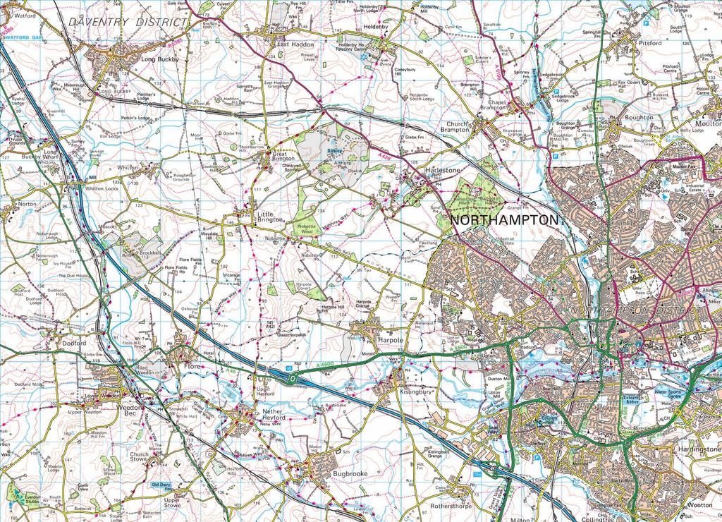
2 SECTION A: Answer ALL four questions from this section. Question 1: Hydrosphere (a) Study OS Map Extract number 254/152: Northampton (separate item), and Map Q1. Using map evidence, describe the physical characteristics of the Brampton Nene River and its valley from to Map Q1: Location of Brampton Nene River [X28/12/1] Page two
3 Question 1 continued (b) Study Diagram Q1. Describe and explain the changing river levels on the River Nene at Northampton from 29th to 3th April Diagram Q1: Flood Hydrograph for the River Nene in Northampton Precipitation (mm) River level (cm) 1 1 Key hours 29 April 3 April River level (cm) Precipitation (mm) [Turn over [X28/12/1] Page three
4 Question 2: Biosphere (a) Explain in detail what is meant by the term climax vegetation. 4 (b) Study Diagram Q2. Describe and give reasons for the changes in plant types likely to be present across the transect as you move from location 1 at the coast, inland to location 6. You should refer to named plant species in your answer. 14 Diagram Q2: Transect of Sand Dune System m 1 m 2 m 3 m COAST 1 Strand line Sea 2 Embryo dunes 3 Fore dunes 4 Yellow dune Water table 5 Grey dune 6 Dune slack Climax vegetation INLAND [X28/12/1] Page four
5 Question 3: Rural Geography (a) Describe and explain the main characteristics of the agricultural system for intensive peasant farming. 8 (b) For any named area of commercial arable farming: (i) describe the changes in farming practices that have taken place in recent years; and (ii) discuss the impact of these changes on people, the landscape and the environment. 1 [Turn over [X28/12/1] Page five
6 Question 4: Urban Geography (a) For a named city which you have studied in the Developed World, explain the ways in which its site and situation contributed to its growth. 8 (b) Study Map Q4. For Glasgow, or any named developed world city you have studied, describe and explain schemes which have been introduced to reduce problems of traffic management in the Central Business District. 1 Map Q4: Inner-ring road plan to reduce traffic congestion in Glasgow s Central Business District North St St George s Rd Newton St M8 Sauchiehall Street Broomielaw West Graham Street Bath Street St Vincent Street Bothwell Street Waterloo Street Argyle Street River Clyde Morrison Street Oswald Street Dobbie s Loan Cowcaddens Rd Renfrew Street Bridge Commercial Street Jamaica Street Bridge Street Union Street Norfolk St Bath Street Queen St Buchannan Street Argyle Street Clyde Street M8 North Hanover St George Square Glassford Street Kyle St Baird St Cathedral St George Street Ingram Street Trongate Saltmarket High Street Stirling Rd Gallowgate Castle Street Duke Street London Road Royston Road Alexandra Parade Gallowgate Duke Street Cumbernauld Road Inner Ring Road LIKELY ROUTE OPTIONAL ROUTE [X28/12/1] Page six
7 SECTION B: Answer ONE question from this section, ie either Question 5 or Question 6. Question 5: Lithosphere Study Diagram Q5. Select one erosional landform and one depositional landform from Diagram Q5. With the aid of annotated diagrams, explain the formation of each feature. 14 Diagram Q5: A Glaciated Landscape corrie arête hanging valley U-shaped valley terminal moraine esker drumlins roche moutonnée [Turn over [X28/12/1] Page seven
8 DO NOT ANSWER THIS QUESTION IF YOU HAVE ALREADY ANSWERED QUESTION 5 Question 6: Atmosphere (a) Study Diagram Q6A and Map Q6A. Describe the origin and characteristics of the Tropical Maritime and Tropical Continental air masses. 6 Diagram Q6A: The Inter-Tropical Convergence Zone (ITCZ) JANUARY ITCZ Tropical Maritime Tropical Continental X SEA LAND 5 N 1 N 15 N 2 N Y Map Q6A: Location of section X Y Y KEY Area covered by Map Q6B N X AFRICA 1 km [X28/12/1] Page eight
9 DO NOT ANSWER THIS QUESTION IF YOU HAVE ALREADY ANSWERED QUESTION 5 Question 6 continued (b) Study Maps Q6A and Q6B and Diagram Q6B. Referring to the position of the ITCZ, describe and explain the changing rainfall pattern as you move inland from Abidjan to Nioro. 8 Map Q6B: West Africa 2 N N 1 N 5 km NIORO OUAGADOUGOU 1 ABIDJAN KEY 1 Isohyets showing mean annual rainfall (mm) Diagram Q6B: West Africa selected rainfall graphs Abidjan Ouagadougou Nioro Precipitation (mm) Precipitation (mm) Precipitation (mm) J F M A M J J A S O N D J F M A M J J A S O N D J F M A M J J A S O N D [Turn over [X28/12/1] Page nine
10 SECTION C: Answer ONE question from this section, ie either Question 7 or Question 8. Question 7: Industrial Geography (a) Study OS Map Extract number 254/152: Northampton (separate item), and Map Q7. Using map evidence, describe and explain the human factors that have encouraged modern industry to locate in area A. 8 Map Q7: Location of Swan Valley industrial area, Northampton A [X28/12/1] Page ten
11 Question 7 continued (b) Study Table Q7. Table Q7: % UK employment by broad sector (projection) Primary sector and utilities 4 3 Manufacturing 17 7 Construction 8 7 Trade, accommodation and transport Other services Changes in employment figures for the UK are similar to those of many old industrial areas of Western Europe. Referring to a named industrial concentration in the European Union, explain why these changes are occurring. 6 [Turn over for Question 8 on Page twelve [X28/12/1] Page eleven
12 DO NOT ANSWER THIS QUESTION IF YOU HAVE ALREADY ANSWERED QUESTION 7 Question 8: Population Map Q8 shows the main origins of USA immigrants. (a) Describe and suggest reasons for the patterns shown on Map Q8. 6 (b) With reference to an international migration you have studied describe the impact on both the donor and receiving country. Map Q8: Origin of immigrants into the USA (number in thousands) 8 China 83 South Korea 23 Philippines 55 Vietnam 33 Mexico 143 USA Cuba 36 Colombia 22 Haiti 22 Dominican Republic 46 India 66 [END OF QUESTION PAPER] [X28/12/1] Page twelve
13 X28/12/11 NATIONAL QUALIFICATIONS 214 THURSDAY, 29 MAY 9. AM 1.3 AM GEOGRAPHY HIGHER Paper 1 Physical and Human Environments Ordnance Survey Map ORDNANCE SURVEY MAP For Questions 1 and 7 Note: The colours used in the printing of this map extract are indicated in the four little boxes at the top of the map extract. Each box should contain a colour; if any does not, the map is incomplete and should be returned to the Invigilator. PB *X28/12/11*
14
15 X28/12/2 NATIONAL QUALIFICATIONS 214 THURSDAY, 29 MAY 1.5 AM 12.5 PM GEOGRAPHY HIGHER Paper 2 Environmental Interactions Answer any two questions. Write the numbers of the two questions you have attempted in the marks grid on the back cover of your answer booklet. The value attached to each question is shown in the margin. Credit will be given for appropriate maps and diagrams, and for reference to named examples. Questions should be answered in sentences. Note The reference maps and diagrams in this paper have been printed in black only: no other colours have been used. PB *X28/12/2*
16 Question 1: Rural Land Resources (a) With the aid of annotated diagrams, describe and explain the formation of the physical features associated with coastal landscapes. You should refer to both erosional and depositional features in your answer. 2 (b) Study Map Q1 and Table Q1. Explain why National Parks attract widely differing numbers of visitors. 1 (c) For any named upland or coastal area you have studied: (i) describe and explain the environmental conflicts that may be caused by large numbers of people visiting the area for tourism and recreation; (ii) describe the measures taken to resolve these environmental conflicts and comment on their effectiveness. Map Q1: UK National Parks 1 1 (5) National Parks Large centres of population Selected Motorways Selected Main Roads N A82 Loch Lomond and the Trossachs M74 M8 A1 Cairngorms A9 M9 M9 Northumberland A1 M6 North York Moors Lake District M62 Yorkshire Dales Peak District Snowdonia M6 M1 A1 M6 M1 M25 Norfolk Broads Pembrokeshire coast Brecon Beacons Exmoor M5 M4 M3 Dartmoor South Downs New Forest [X28/12/2] Page two
17 Question 1 continued Table Q1 : National Park Statistics Name of National Park Designation Year Area (sq km) Visitor days per year (million) Brecon Beacons Cairngorms Dartmoor Exmoor Lake District Loch Lomond and the Trossachs New Forest Norfolk Broads Northumberland North York Moors Peak District Pembrokeshire Coast Snowdonia South Downs Yorkshire Dales [Turn over [X28/12/2] Page three
18 Question 2: Rural Land Degradation (a) (b) (c) Study Map Q2 Describe the climatic conditions found in Chad and explain why such physical conditions may lead to the degradation of rural land. For either Africa north of the equator, or the Amazon Basin: (i) explain how human activities, including inappropriate farming techniques, have led to rural land degradation; and (ii) describe the consequences of rural land degradation on the people and their environment. Referring to named areas of North America which you have studied: (i) describe and explain some of the measures which have been taken to conserve soil and limit rural land degradation; and (ii) comment on the effectiveness of these strategies (5) [X28/12/2] Page four
19 Question 2 continued Map Q2: Climatic Regions of Chad 15 3 km EGYPT 5 Faya-largeau NIGER LIBYA Sahara Desert Temperature ( C) J F MA M J J A S O N D Preciptation (mm) Faya-largeau 5 N Djamena NIGERIA CHAD Sahel N Djamena Savanna Sarh SUDAN Temperature ( C) J F MA M J J A S O N D Preciptation (mm) CAMEROON CENTRAL AFRICAN REPUBLIC 5 Sarh Location of Chad Climatic / Vegetation Region Temperature ( C) J F MA M J J A S O N D Preciptation (mm) 1 km Key: Precipitation (mm) Temperature ( C) [X28/12/2] Page five [Turn over
20 Question 3: River Basin Management (a) Study Map Q3 and Diagrams Q3A and Q3B. Describe and explain why there is a need for water management within the Indus river basin. 12 (b) For the Tarbela Dam, or any dam and reservoir scheme you have studied, describe and explain the physical and human factors that should be considered when selecting the site for a dam and its associated reservoir. 14 (c) Describe and account for the social, economic and environmental benefits and adverse consequences of a named major water control project in Africa or Asia or North America. Map Q3: The Indus Valley, Pakistan, and areas affected by 21 floods 24 (5) Moderately affected districts Severely affected districts River International Border AFGHANISTAN Tarbela Dam KASHMIR Islamabad BALOCHISTAN Indus River Thelum River PUNJAB Sutlej River PAKISTAN INDIA Himalayas AFGHANISTAN Hyderabad SINDH PAKISTAN Islamabad INDIA Arabian Sea Hyderabad [X28/12/2] Page six
21 Question 3 continued Diagram Q3A: Population growth in Pakistan 3 3 Total Population (in millions) Key: Projected Diagram Q3B: Pakistan Climate Graphs 35 Islamabad 35 Temperature ( C) Year Precipitation (mm) J F M A M J J A S O N D Temperature ( C) Hyderabad J F M A M J J A S O N D Precipitation (mm) Key: Precipitation (mm) Temperature ( C) [X28/12/2] Page seven [Turn over
22 Question 4: Urban Change and its Management (a) (b) (c) (d) Study Map Q4A. Describe and account for the distribution of major towns and cities in either Brazil or any other Developing Country which you have studied. Study Map Q4B. There are over 6 shanty towns (favelas) within Rio de Janeiro. With reference to Rio de Janeiro, or any named city that you have studied in a Developing Country, discuss the social, economic and environmental problems of favelas. Study Map Q4B. Rio de Janeiro will host the 214 World Cup and 216 Olympic Games. The favelas nearest to the Olympic and World Cup venues have been targeted for improvement. Referring to Rio de Janeiro, or any named city that you have studied in a Developing Country, describe the methods used to tackle problems in shanty towns and comment on their effectiveness. In March 212, the British Government published the National Planning Policy Framework document, which emphasises the importance of redevelopment within cities. Countryside campaigners believe this is a victory against urban sprawl. With reference to any named city in a Developed Country that you have studied: (i) explain why urban sprawl has occurred; and (ii) describe the problems caused by urban sprawl; and comment on possible solutions (5) [X28/12/2] Page eight
23 Question 4 continued Map Q4A: Map of Brazil COLOMBIA VENEZUELA GUYANA SURINAME FRENCH GUIANA Atlantic Ocean N Belém Manaus Amazon Basin Amazon Fortaleza BRAZIL Recife Salvador da Bahia BOLIVIA Brasilia Key - Population Over 5 million Over 2 million Over 1 million PARAGUAY Santos Curitiba Belo Horizonte Guarulhos Rio de Janeiro Sao Paulo Key ARGENTINA Land over 15m Porto Alegre URUGUAY Map Q4B: Location of favelas, World Cup and Olympic venues in Rio de Janeiro Key DEODORO Planned Olympic zones Favelas Built-up area MARACANÂ Rio de Janeiro BARRA 5 km COPACABANA [X28/12/2] Page nine [Turn over
24 Question 5: European Regional Inequalities (a) Study Map Q5 and Table Q5. To what extent does the data provide evidence of regional inequalities within Portugal? 12 Map Q5: Regions of Portugal N Norte Centro SPAIN Lisboa Alentejo 1 km Algarve Table Q5: Regional statistics Portugal Norte Centro Lisboa Alentejo Algarve Life Expectancy (years) Unemployment Rate (%) % Employed in service sector % Computer access Educational attainment rate in tertiary education (%) [X28/12/2] Page ten
25 Question 5 continued (b) (c) For Portugal or any other country in the European Union (EU), describe and explain the physical and human factors that have contributed to regional differences. For a named country in the EU, select one less developed region and: (i) discuss ways in which the national government and the EU have taken steps to overcome the problems of inequality; and (ii) comment on the effectiveness of these strategies (5) [Turn over [X28/12/2] Page eleven
26 Question 6: Development and Health (a) Study Map Q6 and Table Q6. India s states and union territories can be grouped into six regions. Using the development indicators in Table Q6 below, describe how the information given suggests that the six regions of India are at different levels of development. Map Q6: Six regions of India 8 N AFGHANISTAN Himalayan North CHINA PAKISTAN Western India The Plains NEPAL CHINA (TIBET) BHUTAN Northeastern India Eastern India BURMA BANGLADESH BAY OF BENGAL Southern Southern India India INDIAN OCEAN 3 Km SRI LANKA India Table Q6: Selected indicators of development for India s regions Region % Illiteracy Rate Infant Mortality Rate (per 1 live births) Crude Birth Rate (per 1 of population) % of households without electricity Himalayan North The Plains Western India Southern India Eastern India North-eastern India [X28/12/2] Page twelve
27 Question 6 continued (b) (c) (d) Explain why using only one development indicator, such as Gross Domestic Product (GDP) per capita, may fail to reflect accurately the true quality of life within a country. Explain why countries in the Developing world are at different stages of development. You should refer to named countries that you have studied in your answer. Water-related diseases, such as malaria, cholera and bilharzia/schistosomiasis, are a serious problem in many Developing Countries. For one of the above diseases: (i) describe the measures that have been taken to combat the disease, and comment on how effective these measures have been; (ii) explain the benefits for the Developing Countries in successfully controlling the disease (5) [END OF QUESTION PAPER] [X28/12/2] Page thirteen
28 [BLANK PAGE]
29 [BLANK PAGE]
30 [BLANK PAGE]
THURSDAY, 29 MAY AM PM
 X28/12/2 NATIONAL QUALIFICATIONS 214 THURSDAY, 29 MAY 1.5 AM 12.5 PM GEOGRAPHY HIGHER Paper 2 Environmental Interactions Answer any two questions. Write the numbers of the two questions you have attempted
Write the numbers of the six questions you have attempted in the marks grid on the back cover of your answer booklet.
 X208/301 NATIONAL QUALIFICATIONS 2008 THURSDAY, 22 MAY 9.00 AM 10.30 AM GEOGRAPHY HIGHER Paper 1 Physical and Human Environments Six questions should be attempted, namely: all four questions in Section
*X208/11/01* X208/11/01 GEOGRAPHY INTERMEDIATE 2 NATIONAL QUALIFICATIONS 2014 THURSDAY, 29 MAY 9.00 AM AM
 X208/11/01 NATIONAL QUALIFICATIONS 2014 THURSDAY, 29 MAY 9.00 AM 11.00 AM GEOGRAPHY INTERMEDIATE 2 Candidates should answer four questions: Section A Question 1 and Question 2 AND Section B any two questions
THURSDAY, 30 MAY 9.00 AM AM
 X208/12/01 NATIONAL QUALIFICATIONS 2013 THURSDAY, 30 MAY 9.00 AM 10.30 AM GEOGRAPHY HIGHER Paper 1 Physical and Human Environments Six questions should be attempted, namely: all four questions in Section
Marr College Geography Department. Can-Do Checklist for Higher Geography
 Marr College Geography Department Can-Do Checklist for Higher Geography The Higher Geography exam consists of one paper. It is out of a total of 60 marks. The total time for the paper is 2 hours 15 minutes.
National 5 Geography. Practice Exam Papers
 National 5 Geography Practice Exam Papers December 2017 SPECIMEN QUESTION PAPER 1 SECTION 1: PHYSICAL ENVIRONMENTS Question 1 (a) Study the Ordnance Survey map extract (Item A) of the Pembroke Map area.
GCSE. Edexcel GCSE Geography A (1312 1F) Summer Mark Scheme (Results)
 Summer Mark Scheme (Results)") GCSE Edexcel GCSE Geography A (1312 1F) Summer 2006 Mark Scheme (Results) 1. (a) Look at Figure 1a. It shows population growth for Europe and Africa. (i) What was the population of Europe in 1800?...million
GCSE Edexcel GCSE Geography A (1312 1F) Summer 2006 Mark Scheme (Results) 1. (a) Look at Figure 1a. It shows population growth for Europe and Africa. (i) What was the population of Europe in 1800?...million
Paper Reference. 1312/1F Edexcel GCSE Geography A Paper 1F. Foundation Tier. Monday 5 June 2006 Morning Time: 1 hour 45 minutes
 Centre No. Paper Reference Surname Initial(s) Candidate No. 1 3 1 2 1 F Signature Paper Reference(s) 1312/1F Edexcel GCSE Geography A Paper 1F Foundation Tier Monday 5 June 2006 Morning Time: 1 hour 45
National Quali cations 2017
 N5 X733/75/11 National Quali cations 2017 Geography FRIDAY, 26 MAY 1:00 PM 2:5 PM Total marks 60 SECTION 1 PHYSICAL ENVIRONMENTS 20 marks Attempt EITHER Question 1 OR Question 2. ALSO attempt Questions
N07/3/GEOGR/HP2/ENG/TZ0/XX/Q+ Geography Higher level. Tuesday 13 November 2007 (morning) 2 hours 30 minutes
 2 hours 30 minutes") IB Geography Higher level PAPER 2 DIPLOMA PROGRAMME PROGRAMME DU DIPLÔME DU BI PROGRAMA DEL DIPLOMA DEL BI N07/3/GEOGR/HP2/ENG/TZ0/XX/Q+ 88075202 Tuesday 13 November 2007 (morning) 2 hours 30 minutes instructions
IB Geography Higher level PAPER 2 DIPLOMA PROGRAMME PROGRAMME DU DIPLÔME DU BI PROGRAMA DEL DIPLOMA DEL BI N07/3/GEOGR/HP2/ENG/TZ0/XX/Q+ 88075202 Tuesday 13 November 2007 (morning) 2 hours 30 minutes instructions
National Quali cations
 H 2018 X733/76/11 National Quali cations Geography TUESDAY, 1 MAY 9:00 AM 11:15 AM Total marks 60 SECTION 1 PHYSICAL ENVIRONMENTS 15 marks Attempt ALL questions. SECTION 2 HUMAN ENVIRONMENTS 15 marks Attempt
GCSE 4231/01 GEOGRAPHY
 Surname Centre Number Candidate Number Other Names 0 GCSE 4231/01 GEOGRAPHY (Specification A) FOUNDATION TIER UNIT 1 Core Geography A.M. THURSDAY, 14 June 2012 1 3 4 hours For s use Question 1 Question
M14/3/GEOGR/SP2/ENG/TZ0/XX/Q GEOGRAPHY STANDARD LEVEL PAPER 2. Monday 19 May 2014 (morning) 1 hour 20 minutes INSTRUCTIONS TO CANDIDATES
 1 hour 20 minutes INSTRUCTIONS TO CANDIDATES") M14/3/GEOGR/SP2/ENG/TZ0/XX/Q 22145203 GEOGRAPHY STANDARD LEVEL PAPER 2 Monday 19 May 2014 (morning) 1 hour 20 minutes INSTRUCTIONS TO CANDIDATES Do not open this examination paper until instructed to do
M14/3/GEOGR/SP2/ENG/TZ0/XX/Q 22145203 GEOGRAPHY STANDARD LEVEL PAPER 2 Monday 19 May 2014 (morning) 1 hour 20 minutes INSTRUCTIONS TO CANDIDATES Do not open this examination paper until instructed to do
Paper Reference. Paper Reference(s) 1312/2F Edexcel GCSE Geography A Foundation Tier. Monday 11 June 2007 Afternoon Time: 1 hour 15 minutes
 1312/2F Edexcel GCSE Geography A Foundation Tier. Monday 11 June 2007 Afternoon Time: 1 hour 15 minutes") Centre No. Paper Reference Surname Initial(s) Candidate No. 1 3 1 2 2 F Signature Paper Reference(s) 1312/2F Edexcel GCSE Geography A Foundation Tier Paper 2F Monday 11 June 2007 Afternoon Time: 1 hour
Centre No. Paper Reference Surname Initial(s) Candidate No. 1 3 1 2 2 F Signature Paper Reference(s) 1312/2F Edexcel GCSE Geography A Foundation Tier Paper 2F Monday 11 June 2007 Afternoon Time: 1 hour
GCSE 4231/01 GEOGRAPHY (Specification A) FOUNDATION TIER UNIT 1: Core Geography
 FOUNDATION TIER UNIT 1: Core Geography") Surname Centre Number Candidate Number Other Names 0 GCSE 4231/01 GEOGRAPHY (Specification A) FOUNDATION TIER UNIT 1: Core Geography S16-4231-01 P.M. TUESDAY, 24 May 2016 1 hour 45 minutes For s use Question
Surname Centre Number Candidate Number Other Names 0 GCSE 4231/01 GEOGRAPHY (Specification A) FOUNDATION TIER UNIT 1: Core Geography S16-4231-01 P.M. TUESDAY, 24 May 2016 1 hour 45 minutes For s use Question
National Quali cations 2016
 N5 X733/75/11 National Quali cations 2016 Geography FRIDAY, 6 MAY 1:00 PM 2:45 PM Total marks 60 SECTION 1 PHYSICAL ENVIRONMENTS 20 marks Attempt EITHER question 1 OR question 2. ALSO attempt questions
UK NEA Economic Analysis Report Cultural services: Mourato et al. 2010
 Appendix A Hedonic regressions: Further data description The environmental data used to construct variables for the hedonic regressions come from the Centre for Ecology and Hydrology, the Generalised Land
UNIT 11 SOUTH ASIA SG 1 - PHYSICAL GEOGRAPHY & THE ENVIRONMENT
 UNIT 11 SOUTH ASIA SG 1 - PHYSICAL GEOGRAPHY & THE ENVIRONMENT I. PHYSICAL GEOGRAPHY TAKE OUT YOUR PHYSICAL MAP OF SOUTH ASIA A. The Himalayan Mountains form the northern boundary of the region (color
Cambridge International Examinations Cambridge International General Certificate of Secondary Education
 Cambridge International Examinations Cambridge International General Certificate of Secondary Education *2660755211* GEOGRAPHY 0460/12 Paper 1 May/June 2018 Candidates answer on the Question Paper. Additional
By Geri Flanary To accompany AP Human Geography: A Study Guide 3 rd edition By Ethel Wood
 Session 1 By Geri Flanary To accompany AP Human Geography: A Study Guide 3 rd edition By Ethel Wood WHAT IS DEMOGRAPHY? It is the scientific or statistical study of population. It comes from the Greek
Downloaded from
 GIST OF THE LESSON: General patternsof population distribution in the world, density of population, factors influencing the distribution of population, population growth, trends in population growth, doubling
World Geography Fall 2013 Semester Review Project
 Reporting Category RC 1: History, Government and Citizenship Standard WG.1 History. The student understands how geography and processes of spatial exchange (diffusion) influenced events in the past and
National 5 Geography Course content checklist
 National 5 Geography Course content checklist This checklist is designed to help you check your understanding of the course content. By ticking the relevant colour you can prioritise revision content prior
UNIVERSITY OF CAMBRIDGE INTERNATIONAL EXAMINATIONS International General Certificate of Secondary Education
 UNIVERSITY OF CAMBRIDGE INTERNATIONAL EXAMINATIONS International General Certificate of Secondary Education *3869585710* GEOGRAPHY 0460/12 Paper 1 October/November 2013 Candidates answer on the Question
ANALYZING CITIES & POPULATION: POPULATION GEOGRAPHY
 ANALYZING CITIES & POPULATION: POPULATION GEOGRAPHY Population Geography Population Geography study of the number, contribution, and distribution of human populations Demography the study of the characteristics
Developing a global, peoplebased definition of cities and settlements
 Developing a global, peoplebased definition of cities and settlements By Lewis Dijkstra, Lewis.Dijkstra@ec.europa.eu Head of the Economic Analysis Sector DG for Regional and Urban Policy, Regional & Urban
CNCS GCSE. Case Study and Exam Question Revision Booklet
 1 CNCS GCSE Case Study and Exam Question Revision Booklet Note: there is no single way to respond to a 9 mark question attached is guidance only (Grades 7-9 will require judgement and will need to be more
About the Authors Geography and Tourism: The Attraction of Place p. 1 The Elements of Geography p. 2 Themes of Geography p. 4 Location: The Where of
 Preface p. ix About the Authors p. xi Geography and Tourism: The Attraction of Place p. 1 The Elements of Geography p. 2 Themes of Geography p. 4 Location: The Where of Geography p. 4 Place and Space:
Cambridge International Examinations Cambridge International General Certificate of Secondary Education
 Cambridge International Examinations Cambridge International General Certificate of Secondary Education *1869999605* GEOGRAPHY 0460/11 Paper 1 October/November 2017 Candidates answer on the Question Paper.
Coimisiún na Scrúduithe Stáit State Examinations Commission
 M. 24 Coimisiún na Scrúduithe Stáit State Examinations Commission LEAVING CERTIFICATE EXAMINATION 2004 GEOGRAPHY HIGHER LEVEL MONDAY, 14 JUNE, AFTERNOON 1.30 TO 4.50 Four questions to be answered, namely
GCSE 4232/02 GEOGRAPHY. (Specification A) HIGHER TIER UNIT 2 Options Geography. A.M. FRIDAY, 17 June hour 15 minutes.
 HIGHER TIER UNIT 2 Options Geography. A.M. FRIDAY, 17 June hour 15 minutes.") Candidate Name Centre Number 0 Candidate Number GCSE 4232/02 GEOGRAPHY (Specification A) HIGHER TIER UNIT 2 Options Geography A.M. FRIDAY, 17 June 2011 1 hour 15 minutes Section A Section B For s Use Only
Candidate Name Centre Number 0 Candidate Number GCSE 4232/02 GEOGRAPHY (Specification A) HIGHER TIER UNIT 2 Options Geography A.M. FRIDAY, 17 June 2011 1 hour 15 minutes Section A Section B For s Use Only
GEOGRAPHY 2217/12 Paper 1 October/November 2014
 www.xtremepapers.com Cambridge International Examinations Cambridge Ordinary Level * 6 7 7 2 4 1 7 0 2 4 * GEOGRAPHY 2217/12 Paper 1 October/November 2014 Candidates answer on the Question Paper. Additional
Coimisiún na Scrúduithe Stáit State Examinations Commission
 Coimisiún na Scrúduithe Stáit State Examinations Commission LEAVING CERTIFICATE EXAMINATION GEOGRAPHY HIGHER LEVEL SAMPLE PAPER N.B. Remember to return this paper with your answer-book. Otherwise, marks
UNIVERSITY OF CAMBRIDGE INTERNATIONAL EXAMINATIONS General Certificate of Education Ordinary Level. GEOGRAPHY 2217/22 Paper 2 October/November 2012
 www.xtremepapers.com UNIVERSITY OF CAMBRIDGE INTERNATIONAL EXAMINATIONS General Certificate of Education Ordinary Level *6214389152* GEOGRAPHY 2217/22 Paper 2 October/November 2012 Candidates answer on
Paper Reference. Paper Reference(s) 1312/1F Edexcel GCSE Geography A Paper 1F Foundation Tier Monday 4 June 2007 Morning Time: 1 hour 45 minutes
 1312/1F Edexcel GCSE Geography A Paper 1F Foundation Tier Monday 4 June 2007 Morning Time: 1 hour 45 minutes") Centre No. Candidate No. Paper Reference 1 3 1 2 1 F Paper Reference(s) 1312/1F Edexcel GCSE Geography A Paper 1F Foundation Tier Monday 4 June 2007 Morning Time: 1 hour 45 minutes Materials required for
Centre No. Candidate No. Paper Reference 1 3 1 2 1 F Paper Reference(s) 1312/1F Edexcel GCSE Geography A Paper 1F Foundation Tier Monday 4 June 2007 Morning Time: 1 hour 45 minutes Materials required for
Cambridge International Examinations Cambridge International General Certificate of Secondary Education
 Cambridge International Examinations Cambridge International General Certificate of Secondary Education *7540686501* GEOGRAPHY 0460/21 Paper 2 May/June 2017 1 hour 30 minutes Candidates answer on the Question
Paper Two - Optional Themes for Standard and Higher Level
 Paper Two - Optional Themes for Standard and Higher Level Timing: Approximately 40 minutes for each question (each is worth 20 marks). Choice: Higher Level candidates must answer three questions and Standard
Coimisiún na Scrúduithe Stáit State Examinations Commission
 Coimisiún na Scrúduithe Stáit State Examinations Commission LEAVING CERTIFICATE EXAMINATION GEOGRAPHY ORDINARY LEVEL SAMPLE PAPER N.B. Remember to return this paper with your answer-book. Otherwise, marks
Cambridge International Examinations Cambridge International General Certificate of Secondary Education
 Cambridge International Examinations Cambridge International General Certificate of Secondary Education *1971408231* GEOGRAPHY 0460/23 Paper 2 May/June 2016 Candidates answer on the Question Paper. Additional
South, Southeast, and East Asia. Physical Geography
 South, Southeast, and East Asia Physical Geography Mountains v Mountains are important in Asia because they influence: A. Population patterns B. Movement of people and goods C. Climate Mountains v The
Perth Academy Geography Department Higher Exam CAN-DO CHECKLISTS
 Perth Academy Geography Department Higher Exam CAN-DO CHECKLISTS The following pages tell you what you should know for each unit of the National 5 Geography course in order to prepare thoroughly for the
M11/3/GEOGR/HP2/ENG/TZ0/XX/Q GEOGRAPHY HIGHER LEVEL PAPER 2. Friday 6 May 2011 (morning) 2 hours INSTRUCTIONS TO CANDIDATES
 2 hours INSTRUCTIONS TO CANDIDATES") M11/3/GEOGR/HP2/ENG/TZ0/XX/Q 22115202 GEOGRAPHY HIGHER LEVEL PAPER 2 Friday 6 May 2011 (morning) 2 hours INSTRUCTIONS TO CANDIDATES Do not open this examination paper until instructed to do so. Answer
M11/3/GEOGR/HP2/ENG/TZ0/XX/Q 22115202 GEOGRAPHY HIGHER LEVEL PAPER 2 Friday 6 May 2011 (morning) 2 hours INSTRUCTIONS TO CANDIDATES Do not open this examination paper until instructed to do so. Answer
I. PRACTICAL GEOGRAPHY A. Maps. B. Scale and measurement. C. Map reading and interpretation; D. Interpretation of statistical data;
 TOPICS/CONTENTS/NOTES OBJECTIVES I. PRACTICAL GEOGRAPHY A. Maps Ai define and identify different types and uses of maps B. Scale and measurement distances, areas reduction and enlargement, directions,
Paper Reference. Paper Reference(s) 1312/3H Edexcel GCSE Geography A Paper 3H Higher Tier Monday 6 June 2005 Morning Time: 1 hour 45 minutes
 1312/3H Edexcel GCSE Geography A Paper 3H Higher Tier Monday 6 June 2005 Morning Time: 1 hour 45 minutes") Centre No. Paper Reference Surname Initial(s) Candidate No. 1 3 1 2 3 H Signature Paper Reference(s) 1312/3H Edexcel GCSE Geography A Paper 3H Higher Tier Monday 6 June 2005 Morning Time: 1 hour 45 minutes
Centre No. Paper Reference Surname Initial(s) Candidate No. 1 3 1 2 3 H Signature Paper Reference(s) 1312/3H Edexcel GCSE Geography A Paper 3H Higher Tier Monday 6 June 2005 Morning Time: 1 hour 45 minutes
Physical Geography. Ariel view of the Amazon Rainforest. A Look at the Seven Continents
 Physical Geography In this unit you will learn about general physical geography. The study of the Earth s surface features provides the setting for the human-environmental interactions and for the human
CLASS XII GEOGRAPHY (029) SAMPLE QUESTION PAPER ( ) Time allowed - 3 Hrs. Max. Marks 70
 SAMPLE QUESTION PAPER ( ) Time allowed - 3 Hrs. Max. Marks 70") CLASS XII GEOGRAPHY (029) SAMPLE QUESTION PAPER (208-9) Time allowed - 3 Hrs. Max. Marks 70 General Instructions: There are 22 general questions. Questions No. 7 are very short-answer questions carrying
CLASS XII GEOGRAPHY (029) SAMPLE QUESTION PAPER (208-9) Time allowed - 3 Hrs. Max. Marks 70 General Instructions: There are 22 general questions. Questions No. 7 are very short-answer questions carrying
iv vi x Using maps 2 Using images and analysing data 6 Using new technologies in geography 8
 Contents Exam board specification map Introduction Topic checker iv vi x Geographical skills Using maps 2 Using images and analysing data 6 Using new technologies in geography 8 Natural hazards Tectonic
Downloaded from
 I II III IV V VI Define the following terms:- a) Orbitb) Meteoroids c) Celestial bodies GEOGRAPHY ASSIGNMENTS The Earth In The Solar System d) Satellite e) Comets Give one word answers:- a) Blue planet
New GCSE Geography AQA
 Learning Checklist Half Term 1 26 th September 3 rd October 10 th October 17 th October 1.1.1 Tectonic Hazards Plate tectonics theory. Global distribution of earthquakes and volcanic eruptions and their
GEOGRAPHY - HIGHER LEVEL
 M.24 AN ROINN OIDEACHAIS AGUS EOLAÍOCHTA LEAVING CERTIFICATE EXAMINATION 2000 GEOGRAPHY - HIGHER LEVEL MONDAY, 12 JUNE AFTERNOON 2.00 TO 5.20 Four questions to be answered, namely Question 1, Question
Geography Exams. RAG rate The Challenge of Natural Hazards
 Geography Exams You will sit three papers, Paper 1 will last 1 hour 30 minutes and will examine your understanding of The Challenge of Natural Hazards, The Living World and Physical Landscapes in the UK.
2018 Geography Mock Examination
 2018 Geography Mock Examination Your Geography mock examination will test your understanding of Paper 1 (Living with the physical environment) and Section B (Fieldwork) from Paper 2. Attached are the necessary
Cambridge International Examinations Cambridge International Advanced Subsidiary and Advanced Level
 Cambridge International Examinations Cambridge International Advanced Subsidiary and Advanced Level *4188822860* GEOGRAPHY 9696/12 Paper 1 Core Geography October/November 2017 No Additional Materials are
Coimisiún na Scrúduithe Stáit State Examinations Commission
 2009. M24 Coimisiún na Scrúduithe Stáit State Examinations Commission LEAVING CERTIFICATE EXAMINATION, 2009 GEOGRAPHY HIGHER LEVEL FRIDAY 5 JUNE AFTERNOON 2.00 to 4.50 Examination Number For the Examiner
The Impact of Geography in South and East Asia
 The Impact of Geography in South and East Asia Gobi desert, Mongolia Essential Question: How does the geography of SE Asia impact trade and the distribution of population throughout the region? (AKS #52a)
GRAAD 12 NATIONAL SENIOR CERTIFICATE GRADE 12
 GRAAD 12 NATIONAL SENIOR CERTIFICATE GRADE 12 GEOGRAPHY P1 FEBRUARY/MARCH 2013 MARKS: 300 TIME: 3 hours This question paper consists of 11 pages and a 12-page annexure. Geography/P1 2 DBE/Feb. Mar. 2013
Chapter 21 Southwest Asia: Harsh & Arid Lands
 Name Hour Chapter 21 Southwest Asia: Harsh & Arid Lands Essential Question: How has the physical geography of Asia influenced the development of these regions (i.e. history, population distribution, &
NEW. Junior Certificate Geography. LiamAshe Kieran McCarthy
 NEW Junior Certificate Geography LiamAshe Kieran McCarthy THE EDUCATIONAL COMPANY OF IRELAND Contents Section 1 Physical Geography Chapter 1 The Earth 1.1 The Solar System 1.2 The Structure of Earth 1.3
Geography Route Planner
 Geography Route Planner Introduction to Route Planners Route Planners outline the Key Stages 1-3 curriculum to be taught within each campus of the Bury St Edmunds Trust. Each Route Planner has been designed
The Impact of Geography in South and East Asia
 The Impact of Geography in South and East Asia Gobi desert, Mongolia Essential Question: How does the geography of SE Asia impact trade and the distribution of population throughout the region? (AKS #52a)
Chapter 9: Looking Beyond Poverty: The Development Continuum
 Chapter 9: Looking Beyond Poverty: The Development Continuum Using measures such as Gross Domestic Product (GDP), Gross National Income (GNI), and more recently the Human Development Index (HDI), various
Cambridge International Examinations Cambridge Ordinary Level
 Cambridge International Examinations Cambridge Ordinary Level *0607581492* GEOGRAPHY 2217/13 Paper 1 October/November 2018 1 hour 45 minutes Candidates answer on the Question Paper. Additional Materials:
SECONDARY EDUCATION CERTIFICATE LEVEL SAMPLE PAPER SEC 15
 MATRICULATION AND SECONDARY EDUCATION CERTIFICATE EXAMINATIONS BOARD UNIVERSITY OF MALTA SECONDARY EDUCATION CERTIFICATE LEVEL SAMPLE PAPER SEC 15 SUBJECT : PAPER NUMBER: DATE: TIME: GEOGRAPHY IIA Direction
Chapter 1. Social Studies History and Geography
 Chapter 1 Social Studies History and Geography Unit 01 Geography Skills 1 Reading Maps Key Words border landform rely on display focus on route locater 1 There are many different kinds of maps. A political
Cambridge International Examinations Cambridge Ordinary Level
 Cambridge International Examinations Cambridge Ordinary Level *4890089326* GEOGRAPHY 2217/22 Paper 2 May/June 2017 Candidates answer on the Question Paper. Additional Materials: Ruler Calculator Protractor
Geography. Programmes of study for Key Stages 1-3
 Geography Programmes of study for Key Stages 1-3 February 2013 Contents Purpose of study 3 Aims 3 Attainment targets 3 Subject content 4 Key Stage 1 4 Key Stage 2 5 Key Stage 3 6 2 Purpose of study A high-quality
Central Valley School District Social Studies Curriculum Map Grade 7. August - September
 August - September Geographical/Historical Skills Identify and analyze timelines. Construct and use cause and effect charts. Differentiate between fact and opinion. Use of word webs, flip charts, outlines
The City School. PAF Chapter. Comprehensive Worksheet Answering Key December 2017 GEOGRAPHY Class 6
 The City School PAF Chapter Comprehensive Worksheet Answering Key December 2017 GEOGRAPHY Class 6 Candidate Name: Index Number: Section: Branch/Campus: Date: Maximum Marks: 50 Time Allowed: 1 hour 30 minutes
UNIVERSITY OF CAMBRIDGE INTERNATIONAL EXAMINATIONS International General Certificate of Secondary Education
 UNIVERSITY OF CAMBRIDGE INTERNATIONAL EXAMINATIONS International General Certificate of Secondary Education *9231176876* GEOGRAPHY 0460/12 Paper 1 May/June 2013 Candidates answer on the Question Paper.
ENVIRONMENTAL AND DEVELOPMENT ISSUES SAMPLE ASSESSMENT MATERIALS
 GCSE GEOGRAPHY A Sample Assessment Materials 47 GCSE GEOGRAPHY A COMPONENT 2 ENVIRONMENTAL AND DEVELOPMENT ISSUES SAMPLE ASSESSMENT MATERIALS 1 hour 30 minutes Section Question Mark SPaG A B 1 2 Either
Departmental Curriculum Planning
 Departmental Curriculum Planning 2014 2015 Department: Geography Subject: Geography Key Stage: 3 Year Group: 7 Programme of Study Topic (s) studies Key skills taught / developed / assessed Module 1 Module
Range of Opportunities
 Geograhy Curriculum Cropwell Bishop Primary School Range of Opportunities Year 1 Year 2 Year 3 Year 4 Year 5 Year 6 All Key Stage 1 Key Stage 2 Investigate the countries and capitals of the United Kingdom.
Unit 1: Geography. For additional information, refer to this website: 1 G e o g r a p h y
 Unit 1: Geography For additional information, refer to this website: http://mryoungtms.weebly.com/ 1 G e o g r a p h y Continents and Oceans SOL USI. 2a Essential Understanding: Continents are large land
Edexcel GCSE Geography A
 Edexcel GCSE Comparing the 2012 AQA GCSE specification with the new 2016 Edexcel specification This document is designed to help you compare the existing 2012 AQA GCSE specification (9030) with the new
N05/3/GEOGR/HP2/ENG/TZ0/XX/Q GEOGRAPHY HIGHER LEVEL PAPER 2. Monday 7 November 2005 (morning) 2 hours 30 minutes INSTRUCTIONS TO CANDIDATES
 2 hours 30 minutes INSTRUCTIONS TO CANDIDATES") IB GEOGRAPHY HIGHER LEVEL PAPER 2 DIPLOMA PROGRAMME PROGRAMME DU DIPLÔME DU BI PROGRAMA DEL DIPLOMA DEL BI 88055202 Monday 7 November 2005 (morning) 2 hours 30 minutes INSTRUCTIONS TO CANDIDATES Do not
IB GEOGRAPHY HIGHER LEVEL PAPER 2 DIPLOMA PROGRAMME PROGRAMME DU DIPLÔME DU BI PROGRAMA DEL DIPLOMA DEL BI 88055202 Monday 7 November 2005 (morning) 2 hours 30 minutes INSTRUCTIONS TO CANDIDATES Do not
Cambridge International Examinations Cambridge Ordinary Level
 Cambridge International Examinations Cambridge Ordinary Level *2207173583* GEOGRAPHY 2217/13 Paper 1 May/June 2017 Candidates answer on the Question Paper. Additional Materials: Calculator Ruler 1 hour
Wednesday 3 June 2015 Afternoon
 Oxford Cambridge and RSA Wednesday 3 June 2015 Afternoon GCSE GEOGRAPHY B (and Short Course) B563/A772/01/02/RB Key Geographical Themes (Foundation and Higher Tier) RESOURCE BOOKLET *4391029648* INFORMATION
2008 SIVECO Romania. All Rights Reserved. Geography. AeL econtent Catalogue
 2008 SIVECO Romania. All Rights Reserved. Geography AeL econtent Catalogue The Earth's Movements Recommended for two hours of teaching. AeL Code: 352. 2. The Earth Rotation Movement in 24 hours 3. The
GCSE GEOGRAPHY Paper 1: Living with the physical environment
 SPECIMEN ASSESSMENT MATERIAL: SET 3 Please write clearly, in block capitals. Centre number Candidate number Surname Forename(s) Candidate signature GCSE GEOGRAPHY Paper 1: Living with the physical environment
Paper Reference. Paper Reference(s) 1312/4H Edexcel GCSE Geography A Higher Tier. Monday 11 June 2007 Afternoon Time: 1 hour 15 minutes
 1312/4H Edexcel GCSE Geography A Higher Tier. Monday 11 June 2007 Afternoon Time: 1 hour 15 minutes") Centre No. Paper Reference Surname Initial(s) Candidate No. 1 3 1 2 4 H Signature Paper Reference(s) 1312/4H Edexcel GCSE Geography A Higher Tier Paper 4H Monday 11 June 2007 Afternoon Time: 1 hour 15
Centre No. Paper Reference Surname Initial(s) Candidate No. 1 3 1 2 4 H Signature Paper Reference(s) 1312/4H Edexcel GCSE Geography A Higher Tier Paper 4H Monday 11 June 2007 Afternoon Time: 1 hour 15
1 Study the map of Cornwall below. Answer the question that follows.
 Distance and direction 1 Study the map of Cornwall below. Answer the question that follows. five statements that are correct. Lanreath is about 22 km from Plymouth Lanreath is about 28 km from Plymouth
1. Match the words in the first column to the meaning in the second column. [5]
![1. Match the words in the first column to the meaning in the second column. [5]](/thumbs/96/126839765.jpg "1. Match the words in the first column to the meaning in the second column. [5]") Exercise 1: [40 POINTS] 1. Match the words in the first column to the meaning in the second column. [5] Equator Around earth between the Equator and the Poles. Greenwich meridian Half of earth. Longitude
Exercise 1: [40 POINTS] 1. Match the words in the first column to the meaning in the second column. [5] Equator Around earth between the Equator and the Poles. Greenwich meridian Half of earth. Longitude
Cambridge International Examinations Cambridge International General Certificate of Secondary Education
 Cambridge International Examinations Cambridge International General Certificate of Secondary Education *9005889686* GEOGRAPHY 0460/12 Paper 1 May/June 2014 1 hour 45 minutes Candidates answer on the Question
Cambridge International Examinations Cambridge International General Certificate of Secondary Education
 Cambridge International Examinations Cambridge International General Certificate of Secondary Education *5317218974* GEOGRAPHY 0460/22 Paper 2 February/March 2018 Candidates answer on the Question Paper.
Tropical Moist Rainforest
 Tropical or Lowlatitude Climates: Controlled by equatorial tropical air masses Tropical Moist Rainforest Rainfall is heavy in all months - more than 250 cm. (100 in.). Common temperatures of 27 C (80 F)
Middle School. Assessment Focus: Strand 2 Developing a Geographic Perspective. Geography Content Standard Location, Movement, and Connection
 MS05 Michigan Geographic Alliance(1996) Geography Sample Item Middle School Assessment Focus: Strand 2 Developing a Geographic Perspective Geography Content Standard Location, Movement, and Connection
PAKISTAN STUDIES 2059/02 The Environment of Pakistan
 PAKISTAN STUDIES 2059/02 The Environment of Pakistan The City School PAF Chapter Prep + Senior 1 Section Name: Section: Date: Time: 1 hour 30 minute Candidates answer on the Question Paper. READ THESE
Amarillo ISD Social Studies Curriculum
 Amarillo Independent School District follows the Texas Essential Knowledge and Skills (TEKS). All of AISD curriculum and documents and resources are aligned to the TEKS. The State of Texas State Board
TEKS: 1A, 2A, 6B, 9A, 13A, 18A
 SOCIAL STUDIES World Geography Curriculum Based Assessment (CBA) #5 TEKS: 1A, 2A, 6B, 9A, 13A, 18A World Geography, CBA 5, 5th Six Weeks WG 1.A Analyze the effects of physical and human geographic patterns
This table connects the content provided by Education Perfect to the NSW Syllabus.
 Education Perfect Geography provides teachers with a wide range of quality, engaging and innovative content to drive positive student learning outcomes. Designed by teachers and written by our in-house
Factors Affecting Human Settlement
 Factors Affecting Human Settlement Physical Factors One of the most basic factors affecting settlement patterns is the physical geography of the land. Climate is key, because if a place is too dry, too
Map List. 560 World World Physical World Physical-Pacific & Atlantic Region World Landforms World Ocean Floor 10
 Map List CategoryName Map# MapName Thumb nail Page # 560 World 2 561 World Physical 4 562 World Physical-Pacific & Atlantic Region 6 563 World Landforms 8 564 World Ocean Floor 10 565 North Polar Region
GINA Children. II Global Index for humanitarian Needs Assessment (GINA 2004) Sheet N V V VI VIII IX X XI XII XII HDR2003 HDR 2003 UNDP
 Sheet N V V VI VIII IX X XI XII XII HDR2003 HDR 2003 UNDP") Human UNICEF Index Index Natural 2003 GDP per Total as % of Total Rate HDI HPI Disasters Conflicts capita Population population 5 1 Congo, Democratic Republic of the 2,80000 3 3 1 3 3 3 3 3 3 3 2 Burundi
Human UNICEF Index Index Natural 2003 GDP per Total as % of Total Rate HDI HPI Disasters Conflicts capita Population population 5 1 Congo, Democratic Republic of the 2,80000 3 3 1 3 3 3 3 3 3 3 2 Burundi
Cambridge International Examinations Cambridge International Advanced Subsidiary and Advanced Level
 Cambridge International Examinations Cambridge International Advanced Subsidiary and Advanced Level *9303531352* GEOGRAPHY 9696/11 Paper 1 Core Geography May/June 2014 No Additional Materials are required.
Discovering the World of Geography
 Discovering the World of Geography Grades 7 8 By MYRL SHIREMAN COPYRIGHT 2003 Mark Twain Media, Inc. ISBN 10-digit: 1-58037-230-9 13-digit: 978-1-58037-230-5 Printing No. CD-1576 Mark Twain Media, Inc.,
European Union Can you label the twenty-seven countries of the EU on the map attached? (Do not revise the capitals.)
") NAME: FORM: YEAR 5 SUMMER EXAM REVISION QUESTIONS 2016 The exam will be forty minutes long. Answers will be short sentences or just one-word answers. The exam will be based upon the work that you have
NAME: FORM: YEAR 5 SUMMER EXAM REVISION QUESTIONS 2016 The exam will be forty minutes long. Answers will be short sentences or just one-word answers. The exam will be based upon the work that you have
Population Density and Growth. Distribution of people on Earth
 Population Density and Growth Distribution of people on Earth Population Density! Terminology!! Population density is a measure of how compact or concentrated a population is. It takes area of land into
GEOGRAPHY Practice Answer Paper - 2
 GEOGRAPHY Practice Answer Paper - 2 Q.1) Select the correct option and rewrite the sentence : 4 1) According to Census 2011, the average population density of India is 382 persons per sq.km. 2) The rate
Cambridge International Examinations Cambridge International General Certificate of Secondary Education
 Cambridge International Examinations Cambridge International General Certificate of Secondary Education *3123242964* GEOGRAPHY 0460/22 Paper 2 October/November 2014 Candidates answer on the Question Paper.
Coimisiún na Scrúduithe Stáit State Examinations Commission
 2008. M.24 Coimisiún na Scrúduithe Stáit State Examinations Commission LEAVING CERTIFICATE EXAMINATION, 2008 GEOGRAPHY HIGHER LEVEL FRIDAY, 6 JUNE AFTERNOON, 2.00 TO 4.50 Examination Number For the Examiner