Preferred citation style for this presentation
|
|
|
- Basil Underwood
- 6 years ago
- Views:
Transcription
1 Preferred citation style for this presentation Erath, Alex (2013) Activity based modelling, accessibility and high rises, Digital Fabrication Seminar input lecture, Future Cities Laboratory, March
2 Activity based modelling, accessibility and high rises Alex Erath Modulue VIII Mobility and Transportation Future Cities Laboratory Singapore ETH Centre March 2013


3 Principles of agent-based transport modeling 3

4 Agent-based transport demand modeling and simulation with MATSIM <person id= " sex= m" age= 35" license="yes" car_avail="always" employed="yes travelcard ype= halbtax" /> <plan selected="yes"> <act type="home" link="22399" x=" " y=" " start_time="00:00:00" dur="06:45:00 end_time="06:45:00" /> <leg num= 1" mode="car" dep_time="06:45:00" trav_time="00:30:11" arr_time="07:15:11"> <route dist= " trav_time="00:30:11"> </route> </leg> <act type="work" link="22401" x=" " y=" " start_time="07:15:11" dur="10:00:00 end_time="17:15:11" /> </plan> </person>


5 MATSim Singapore 5 million agents 3.3. activities per agent observed travel diaries trips 7 days of EZ Link Data cars home locations 2.3 million places of work links 362 lines 10 desktops = 1 server 1 day = 50 minutes 648 count stations 5

6 A morning A in Singapore with MATSim 6
7 What do we know about activities? Travel diary Household interview travel survey (HITS) 1% of Singapore s resident population Only trips > 500m Underreporting of short activities, e.g. lunch, shopping 7
8 What do we know about activities: example Singapore 8
9 What do we know about activities? Travel diary Only trips > 500m Underreporting of short activities, e.g. lunch, shopping Location of main activities Home and work location from censuses Connection between home and work location according to observed patterns 9


10 What do we know about activities Home Work, primary, secondary, tertiary, other 10
11 What do we know about activities? Travel diary Only trips > 500m Underreporting of short activities, e.g. lunch, shopping Location of main activities Home and work location from censuses Connection between home and work location according to observed patterns Location of secondary, in-between activities Dependent on main activities Within time space prism 11
12 What do we know about activities 12


13 Change of scale: with MATSim Dobler, C. and G. Lämmel (2012) Integration of a multi-modal simulation module into a framework for large-scale transpor systems simulation, paper presented at the Pedestrian and Evacuation Dynamics 2012, Zurich, June
14 Measuring space and opportunities: accessibility Simplest form: A i n d j 1 ij With distance threshold A id O d d As distance weighted sum A i O n j d d ij 14
15 Sevtsuk, Andres Path and Place : a Study of Urban Geometry and Retail Activity in Cambridge and Somerville, MA. Massachusetts Institute of Technology. Measuring space and opportunities: accessibility Change of number of opportunities Change of layout Change of spatial form 15
 The Geometry of Environment, M.I.T. Press, Cambridge, pp. 24 25ff.")
16 Measuring space and opportunities: graph based approaches March, L. and Steadman, P. (1974) The Geometry of Environment, M.I.T. Press, Cambridge, pp ff. (First published (1971) RIBA Publications Limited, London.) 16
 What will the future city look like The city of transaction, presentation held at IBM Smart Cities Seminar, Helsinki, Oct")
17 Basic idea of Space Syntax Tim Stonor. (2011) What will the future city look like The city of transaction, presentation held at IBM Smart Cities Seminar, Helsinki, Oct 2011, tion.swf?slideboom_skin=0 17


18 Space Syntax applied to city street network Tim Stonor. (2011) What will the future city look like The city of transaction, presentation held at IBM Smart Cities Seminar, Helsinki, Oct 2011, 18
 What will the future city look like The city of transaction,")

19 Basic idea of Space Syntax I: Angle turn count Tim Stonor. (2011) What will the future city look like The city of transaction, presentation held at IBM Smart Cities Seminar, Helsinki, Oct 2011, 19
 What will the future city look like The city of transaction,")

20 Space Syntax: comparison with economic activity Tim Stonor. (2011) What will the future city look like The city of transaction, presentation held at IBM Smart Cities Seminar, Helsinki, Oct 2011, 20


21 Another measure, similar result: betweenness Sevtsuk, Andres Path and Place : a Study of Urban Geometry and Retail Activity in Cambridge and Somerville, MA. Massachusetts Institute of Technology. 21
22 Space syntax and agent-based modelling 22
 What will the future city look like The city of transaction, presentation held at IBM Smart")
23 Tim Stonor. (2011) What will the future city look like The city of transaction, presentation held at IBM Smart Cities Seminar, Helsinki, Oct Visibility and location choice within a shopping centre 23


24 Rem Kohlhaas ( 1994) Delirious New York: a retroactive manifesto for Manhattan., reprint, The Monacelli Press. Different activities in a highrise: downtown athletic club 24

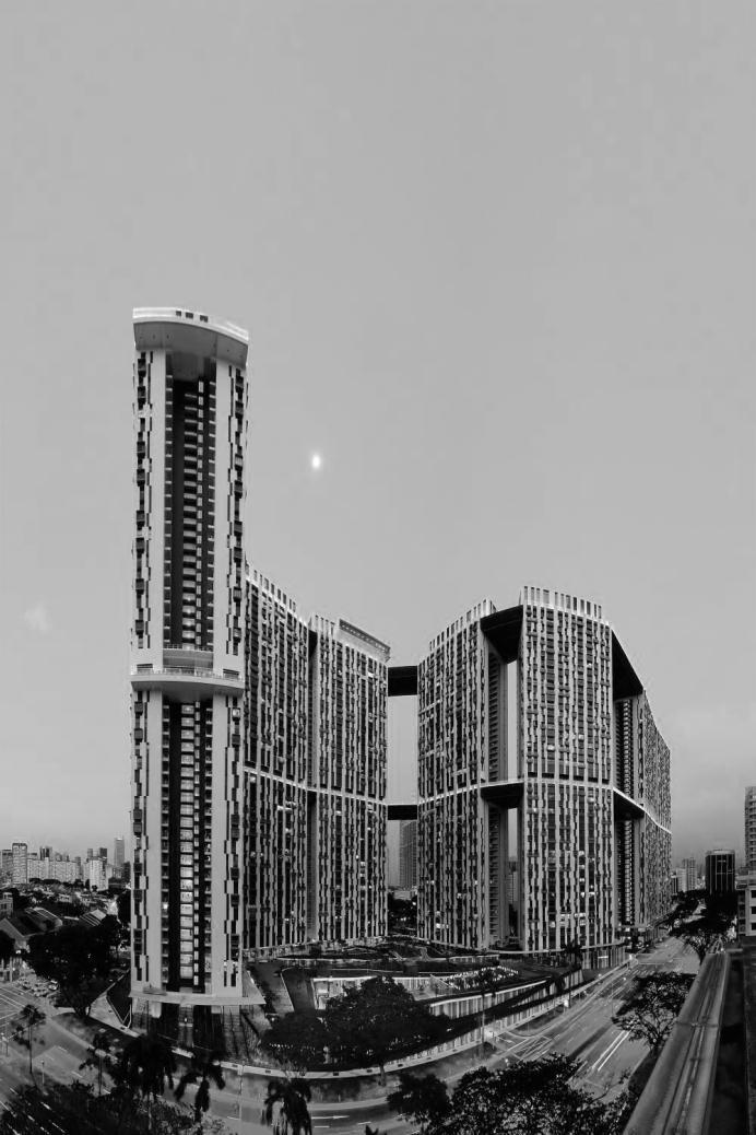
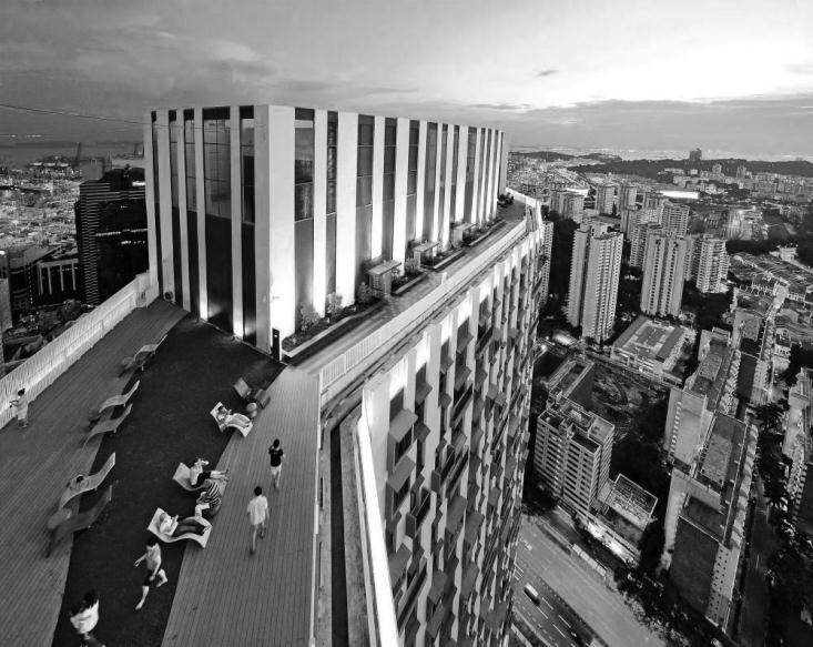

25 Mainly monofunctional activities in a highrise: 25
26 Wrapp up: type of activity and patronage Mandatory activities Frame our daily lives Repetitive activities Different patronage densities for home/work/education Planned secondary activities Having lunch, daily shopping and leisure activities Conscious decision making Bring people together Induced secondary activities Performed because of convenient opportunity, e.g. beer at the pub, lunch in the park Subconscious decision making High activity density -> make a lively environment Bring even more people together 26
Data driven approaches to Urban Planning Experience from Derry/Londonderry
 Data driven approaches to Urban Planning Experience from Derry/Londonderry Anna Rose RTPI Belfast 11 th of September 1 June 26 07:47AM 2 The value of the City The space of the city is a theatre: playing
Mapping Accessibility Over Time
 Journal of Maps, 2006, 76-87 Mapping Accessibility Over Time AHMED EL-GENEIDY and DAVID LEVINSON University of Minnesota, 500 Pillsbury Drive S.E., Minneapolis, MN 55455, USA; geneidy@umn.edu (Received
SPACE-TIME ACCESSIBILITY MEASURES FOR EVALUATING MOBILITY-RELATED SOCIAL EXCLUSION OF THE ELDERLY
 SPACE-TIME ACCESSIBILITY MEASURES FOR EVALUATING MOBILITY-RELATED SOCIAL EXCLUSION OF THE ELDERLY Izumiyama, Hiroshi Institute of Environmental Studies, The University of Tokyo, Tokyo, Japan Email: izumiyama@ut.t.u-tokyo.ac.jp
River North Multi-Modal Transit Analysis
 River North Multi-Modal Transit Analysis November 7, 2006 Dan Meyers, AICP URS Corporation 612-373-6446 / dan_meyers@urscorp.com River North Study Area Reasons for initiating the study Downtown areas north
Measuring connectivity in London
 Measuring connectivity in London OECD, Paris 30 th October 2017 Simon Cooper TfL City Planning 1 Overview TfL Connectivity measures in TfL PTALs Travel time mapping Catchment analysis WebCAT Current and
California Urban Infill Trip Generation Study. Jim Daisa, P.E.
 California Urban Infill Trip Generation Study Jim Daisa, P.E. What We Did in the Study Develop trip generation rates for land uses in urban areas of California Establish a California urban land use trip
Forecasts from the Strategy Planning Model
 Forecasts from the Strategy Planning Model Appendix A A12.1 As reported in Chapter 4, we used the Greater Manchester Strategy Planning Model (SPM) to test our long-term transport strategy. A12.2 The origins
Analysis of the urban travel structure using smartcard and GPS data from Santiago, Chile
 Analysis of the urban travel structure using smartcard and GPS data from Santiago, Chile Marcela Munizaga, Felipe Hernández, Universidad de Chile Ricardo Hurtubia, Pontificia Universidad Católica de Chile
Figure 8.2a Variation of suburban character, transit access and pedestrian accessibility by TAZ label in the study area
 Figure 8.2a Variation of suburban character, transit access and pedestrian accessibility by TAZ label in the study area Figure 8.2b Variation of suburban character, commercial residential balance and mix
Understanding Land Use and Walk Behavior in Utah
 Understanding Land Use and Walk Behavior in Utah 15 th TRB National Transportation Planning Applications Conference Callie New GIS Analyst + Planner STUDY AREA STUDY AREA 11 statistical areas (2010 census)
Place Syntax Tool (PST)
") Place Syntax Tool (PST) Alexander Ståhle To cite this report: Alexander Ståhle (2012) Place Syntax Tool (PST), in Angela Hull, Cecília Silva and Luca Bertolini (Eds.) Accessibility Instruments for Planning
Place Syntax Tool (PST) Alexander Ståhle To cite this report: Alexander Ståhle (2012) Place Syntax Tool (PST), in Angela Hull, Cecília Silva and Luca Bertolini (Eds.) Accessibility Instruments for Planning
CIV3703 Transport Engineering. Module 2 Transport Modelling
 CIV3703 Transport Engineering Module Transport Modelling Objectives Upon successful completion of this module you should be able to: carry out trip generation calculations using linear regression and category
M. Saraiva* 1 and J. Barros 1. * Keywords: Agent-Based Models, Urban Flows, Accessibility, Centrality.
 The AXS Model: an agent-based simulation model for urban flows M. Saraiva* 1 and J. Barros 1 1 Department of Geography, Birkbeck, University of London, 32 Tavistock Square, London, WC1H 9EZ *Email: m.saraiva@mail.bbk.ac.uk
Subject: Note on spatial issues in Urban South Africa From: Alain Bertaud Date: Oct 7, A. Spatial issues
 Page 1 of 6 Subject: Note on spatial issues in Urban South Africa From: Alain Bertaud Date: Oct 7, 2009 A. Spatial issues 1. Spatial issues and the South African economy Spatial concentration of economic
Data Collection. Lecture Notes in Transportation Systems Engineering. Prof. Tom V. Mathew. 1 Overview 1
 Data Collection Lecture Notes in Transportation Systems Engineering Prof. Tom V. Mathew Contents 1 Overview 1 2 Survey design 2 2.1 Information needed................................. 2 2.2 Study area.....................................
GCSE 4232/02 GEOGRAPHY. (Specification A) HIGHER TIER UNIT 2 Options Geography. A.M. FRIDAY, 17 June hour 15 minutes.
 HIGHER TIER UNIT 2 Options Geography. A.M. FRIDAY, 17 June hour 15 minutes.") Candidate Name Centre Number 0 Candidate Number GCSE 4232/02 GEOGRAPHY (Specification A) HIGHER TIER UNIT 2 Options Geography A.M. FRIDAY, 17 June 2011 1 hour 15 minutes Section A Section B For s Use Only
Candidate Name Centre Number 0 Candidate Number GCSE 4232/02 GEOGRAPHY (Specification A) HIGHER TIER UNIT 2 Options Geography A.M. FRIDAY, 17 June 2011 1 hour 15 minutes Section A Section B For s Use Only
Analysis and Design of Urban Transportation Network for Pyi Gyi Ta Gon Township PHOO PWINT ZAN 1, DR. NILAR AYE 2
 www.semargroup.org, www.ijsetr.com ISSN 2319-8885 Vol.03,Issue.10 May-2014, Pages:2058-2063 Analysis and Design of Urban Transportation Network for Pyi Gyi Ta Gon Township PHOO PWINT ZAN 1, DR. NILAR AYE
The 3V Approach. Transforming the Urban Space through Transit Oriented Development. Gerald Ollivier Transport Cluster Leader World Bank Hub Singapore
 Transforming the Urban Space through Transit Oriented Development The 3V Approach Gerald Ollivier Transport Cluster Leader World Bank Hub Singapore MDTF on Sustainable Urbanization The China-World Bank
Encapsulating Urban Traffic Rhythms into Road Networks
 Encapsulating Urban Traffic Rhythms into Road Networks Junjie Wang +, Dong Wei +, Kun He, Hang Gong, Pu Wang * School of Traffic and Transportation Engineering, Central South University, Changsha, Hunan,
GIS Analysis of Crenshaw/LAX Line
 PDD 631 Geographic Information Systems for Public Policy, Planning & Development GIS Analysis of Crenshaw/LAX Line Biying Zhao 6679361256 Professor Barry Waite and Bonnie Shrewsbury May 12 th, 2015 Introduction
PRIMA. Planning for Retailing in Metropolitan Areas
 PRIMA Planning for Retailing in Metropolitan Areas Metropolitan Dimension to sustainable retailing futures Metropolitan strategies Retailing in city and town centres will be a primary component of any
OIM 413 Logistics and Transportation Lecture 7: Basic Sensitivity Analysis and the Braess Paradox
 OIM 413 Logistics and Transportation Lecture 7: Basic Sensitivity Analysis and the Braess Paradox Professor Anna Nagurney John F. Smith Memorial Professor and Director Virtual Center for Supernetworks
The socio-economic effects of the metro line U3 in Vienna (Austria) evaluated under the European research project TranSEcon (www.transecon.
 evaluated under the European research project TranSEcon (www.transecon.") The socio-economic effects of the metro line U3 in Vienna (Austria) evaluated under the European research project TranSEcon (www.transecon.org) This paper is addressed to workshop 1a - Traffic, environment
The socio-economic effects of the metro line U3 in Vienna (Austria) evaluated under the European research project TranSEcon (www.transecon.org) This paper is addressed to workshop 1a - Traffic, environment
Might using the Internet while travelling affect car ownership plans of Millennials? Dr. David McArthur and Dr. Jinhyun Hong
 Might using the Internet while travelling affect car ownership plans of Millennials? Dr. David McArthur and Dr. Jinhyun Hong Introduction Travel habits among Millennials (people born between 1980 and 2000)
CORRIDORS OF FREEDOM Access Management (Ability) Herman Pienaar: Director City Transformation and Spatial Planning
 Herman Pienaar: Director City Transformation and Spatial Planning") CORRIDORS OF FREEDOM Access Management (Ability) 2016 Herman Pienaar: Director City Transformation and Spatial Planning PLANNING DEVELOPMENT PROCESS RATHER THAN A PLAN CAPITAL INVESTMENT DEVELOPMENT FACILITATION
CORRIDORS OF FREEDOM Access Management (Ability) 2016 Herman Pienaar: Director City Transformation and Spatial Planning PLANNING DEVELOPMENT PROCESS RATHER THAN A PLAN CAPITAL INVESTMENT DEVELOPMENT FACILITATION
Exploring the Impact of Ambient Population Measures on Crime Hotspots
 Exploring the Impact of Ambient Population Measures on Crime Hotspots Nick Malleson School of Geography, University of Leeds http://nickmalleson.co.uk/ N.S.Malleson@leeds.ac.uk Martin Andresen Institute
Detecting Origin-Destination Mobility Flows From Geotagged Tweets in Greater Los Angeles Area
 Detecting Origin-Destination Mobility Flows From Geotagged Tweets in Greater Los Angeles Area Song Gao 1, Jiue-An Yang 1,2, Bo Yan 1, Yingjie Hu 1, Krzysztof Janowicz 1, Grant McKenzie 1 1 STKO Lab, Department
Typical information required from the data collection can be grouped into four categories, enumerated as below.
 Chapter 6 Data Collection 6.1 Overview The four-stage modeling, an important tool for forecasting future demand and performance of a transportation system, was developed for evaluating large-scale infrastructure
A route map to calibrate spatial interaction models from GPS movement data
 A route map to calibrate spatial interaction models from GPS movement data K. Sila-Nowicka 1, A.S. Fotheringham 2 1 Urban Big Data Centre School of Political and Social Sciences University of Glasgow Lilybank
Advances in Geographic Data Science and Urban Analytics
 Advances in Geographic Data Science and Urban Analytics Alex Singleton Professor of Geographic Information Science Department of Geography and Planning Consumer Data Research Centre www.cdrc.ac.uk www.geographicdatascience.com
Bus Landscapes: Analyzing Commuting Pattern using Bus Smart Card Data in Beijing
 Bus Landscapes: Analyzing Commuting Pattern using Bus Smart Card Data in Beijing Ying Long, Beijing Institute of City Planning 龙瀛 Jean-Claude Thill, The University of North Carolina at Charlotte 1 INTRODUCTION
Exercise - INSTRUCTIONS
 Learning module: Introduction to Qlik GeoAnalytics Exercise - INSTRUCTIONS Using the Example Download instructions on the right, open the IntroQlikGeoAnalytics_Exercise example in Qlik Sense Desktop and
ASIA GEOSPATIAL FORUM 2011 Eco-Friendly Walk Score Calculator Choosing a Place to Live with GIS
 ASIA GEOSPATIAL FORUM 2011 Eco-Friendly Walk Score Calculator Choosing a Place to Live with GIS Ko Ko Lwin and Yuji Murayama Division of Spatial Information Science Graduate School of Life and Environmental
The Spatial Structure of Cities: International Examples of the Interaction of Government, Topography and Markets
 Module 2: Spatial Analysis and Urban Land Planning The Spatial Structure of Cities: International Examples of the Interaction of Government, Topography and Markets Alain Bertaud Urbanist Summary What are
Estimating Transportation Demand, Part 2
 Transportation Decision-making Principles of Project Evaluation and Programming Estimating Transportation Demand, Part 2 K. C. Sinha and S. Labi Purdue University School of Civil Engineering 1 Estimating
Instituto Superior Técnico Masters in Civil Engineering. Theme 3: Transport networks and external costs. Transport land-use interaction
 Instituto Superior Técnico Masters in Civil Engineering REGIÕES E REDES () Theme 3: Transport land-use interaction Prof. Filipe Moura 1 OUTLINE Transport networks, external costs and market failures Transport
The Trade Area Analysis Model
 The Trade Area Analysis Model Trade area analysis models encompass a variety of techniques designed to generate trade areas around stores or other services based on the probability of an individual patronizing
Traffic Demand Forecast
 Chapter 5 Traffic Demand Forecast One of the important objectives of traffic demand forecast in a transportation master plan study is to examine the concepts and policies in proposed plans by numerically
Transit-Oriented Development. Christoffer Weckström
 Transit-Oriented Development Christoffer Weckström 31.10.2017 Outline Context of Transit-oriented Development Elements of Transit-oriented Development A short history of land use and transit integration
Colleges of Cambridge: The Spatial Interaction between the Town and the Gown. Dima Srouri University College London, UK
 Colleges of Cambridge: The Spatial Interaction between the Town and the Gown Dima Srouri University College London, UK srourid@hotmail.com Abstract This paper investigates the notion of campus community
REAL-TIME GIS OF GENDER
 2 nd Conference on Advanced Modeling and Analysis MOPT/IGOT/CEG REAL-TIME GIS OF GENDER A telegeomonitoring approach PT07 Mainstreaming Gender Equality and Promoting Work Life Balance (2nd Open Call -
The Recognition of Temporal Patterns in Pedestrian Behaviour Using Visual Exploration Tools
 The Recognition of Temporal Patterns in Pedestrian Behaviour Using Visual Exploration Tools I. Kveladze 1, S. C. van der Spek 2, M. J. Kraak 1 1 University of Twente, Faculty of Geo-Information Science
The spatial network Streets and public spaces are the where people move, interact and transact
 The spatial network Streets and public spaces are the where people move, interact and transact The spatial network Cities are big spatial networks that create more of these opportunities Five key discoveries
College Algebra. Word Problems
 College Algebra Word Problems Example 2 (Section P6) The table shows the numbers N (in millions) of subscribers to a cellular telecommunication service in the United States from 2001 through 2010, where
Lecture 19: Common property resources
 Lecture 19: Common property resources Economics 336 Economics 336 (Toronto) Lecture 19: Common property resources 1 / 19 Introduction Common property resource: A resource for which no agent has full property
Designing smart & Resilient cities:
 Designing smart & Resilient cities: How can Egyptian cities learn from an emerging global practice On the Cuspof Change Professor Samer Bagaeen FRICS MRTPI FRSA AoU 1. GLOBAL CHALLENGES POPULATION GROWTH,
Regional Snapshot Series: Transportation and Transit. Commuting and Places of Work in the Fraser Valley Regional District
 Regional Snapshot Series: Transportation and Transit Commuting and Places of Work in the Fraser Valley Regional District TABLE OF CONTENTS Complete Communities Daily Trips Live/Work Ratio Commuting Local
Too Close for Comfort
 Too Close for Comfort Overview South Carolina consists of urban, suburban, and rural communities. Students will utilize maps to label and describe the different land use classifications. Connection to
Location does not matter in the informational age? a case study on the distribution of restaurants listed in dazhongdianping in Beijing
 Beijing City Lab SHENG Qiang, LI Miaoyi, ZHANG Xingyi, 2015, Location does not matter in the informational age? a case study on the distribution of restaurants listed in dazhongdianping in Beijing. Beijing
* Abstract. Keywords: Smart Card Data, Public Transportation, Land Use, Non-negative Matrix Factorization.
 Analysis of Activity Trends Based on Smart Card Data of Public Transportation T. N. Maeda* 1, J. Mori 1, F. Toriumi 1, H. Ohashi 1 1 The University of Tokyo, 7-3-1 Hongo Bunkyo-ku, Tokyo, Japan *Email:
Country Club Plaza Country Club Plaza Saint Charles, Missouri 63303
 Country Club Plaza 1566 Country Club Plaza Saint Charles, Missouri 63303 Jeff Eisenberg P: (314) 721-5611 C: (314) 640-8510 jeff@jeisenberg.com www.jeisenberg.com FORFOR LEASE SALE/LEASE COUNTRY Russell
A/Prof. Mark Zuidgeest ACCESSIBILITY EFFECTS OF RELOCATION AND HOUSING PROJECT FOR THE URBAN POOR IN AHMEDABAD, INDIA
 A/Prof. Mark Zuidgeest ACCESSIBILITY EFFECTS OF RELOCATION AND HOUSING PROJECT FOR THE URBAN POOR IN AHMEDABAD, INDIA South African Cities Network/University of Pretoria, 09 April 2018 MOBILITY Ability
Trip Distribution Analysis of Vadodara City
 GRD Journals Global Research and Development Journal for Engineering Recent Advances in Civil Engineering for Global Sustainability March 2016 e-issn: 2455-5703 Trip Distribution Analysis of Vadodara City
Using Innovative Data in Transportation Planning and Modeling
 Using Innovative Data in Transportation Planning and Modeling presented at 2014 Ground Transportation Technology Symposium: Big Data and Innovative Solutions for Safe, Efficient, and Sustainable Mobility
HORIZON 2030: Land Use & Transportation November 2005
 PROJECTS Land Use An important component of the Horizon transportation planning process involved reviewing the area s comprehensive land use plans to ensure consistency between them and the longrange transportation
Multi agent Evacuation Simulation Data Model for Disaster Management Context
 Multi agent Evacuation Simulation Data Model for Disaster Management Context Mohamed Bakillah, Alexander Zipf, J. Andrés Domínguez, Steve H. L. Liang GI4DM 2012 1 Content Context Requirements for Enhanced
MOBILITIES AND LONG TERM LOCATION CHOICES IN BELGIUM MOBLOC
 MOBILITIES AND LONG TERM LOCATION CHOICES IN BELGIUM MOBLOC A. BAHRI, T. EGGERICKX, S. CARPENTIER, S. KLEIN, PH. GERBER X. PAULY, F. WALLE, PH. TOINT, E. CORNELIS SCIENCE FOR A SUSTAINABLE DEVELOPMENT
Trip and Parking Generation Study of Orem Fitness Center-Abstract
 Trip and Parking Generation Study of Orem Fitness Center-Abstract The Brigham Young University Institute of Transportation Engineers student chapter (BYU ITE) completed a trip and parking generation study
Investigation and Analysis of Urban Spatial Structure around the Train Stations in Kitakyushu by Using Space Syntax and GIS
 Open Journal of Civil Engineering, 2015, 5, 97-108 Published Online March 2015 in SciRes. http://www.scirp.org/journal/ojce http://dx.doi.org/10.4236/ojce.2015.51010 Investigation and Analysis of Urban
PlaceTypes. How the built environment is measured. Variables Measures Levels. AREA TYPE + DEVELOPMENT TYPE = PlaceType
 PlaceTypes In order to better understand land use and transportation interactions and to make more informed policy decisions, neighborhood characteristics can be analyzed by the role that they play in
Space Syntax: Spatial Integration Accessibility and Angular Segment Analysis by Metric Distance (ASAMeD)
") Space Syntax: Spatial Integration Accessibility and Angular Segment Analysis by Metric Distance (ASAMeD) Nadia Charalambous, Magda Mavridou To cite this report: Nadia Charalambous, Magda Mavridou (2012)
Space Syntax: Spatial Integration Accessibility and Angular Segment Analysis by Metric Distance (ASAMeD) Nadia Charalambous, Magda Mavridou To cite this report: Nadia Charalambous, Magda Mavridou (2012)
Determinants of the structural dimension of daily behaviour in a traditional African City: A case study of Ilorin, Nigeria
 15 Determinants of the structural dimension of daily behaviour in a traditional African City: A case study of Ilorin, Nigeria Adedokun Olutoyin Moses 1 1 Department of Geography, Federal College of Education,
Marking Scheme Field Work. 6 International Geography Olympiad. Brisbane
 Marking Scheme Field Work th 6 International Geography Olympiad Brisbane June 2006 Question - Map - 7 Marks Mark out of 4 and divide by 2 at the end. (Sample map was provided to markers.) Shading according
Foreword. Vision and Strategy
 GREATER MANCHESTER SPATIAL FRAMEWORK Friends of Walkden Station Consultation Response January 2017 Foreword Friends of Walkden Station are a group of dedicated volunteers seeking to raise the status and
Stability and innovation of human activity spaces
 Stability and innovation of human activity spaces http://www.ivt.ethz.ch/vpl/publications/reports/ab258.pdf Stefan Schönfelder * IVT - Institute for Transport Planning and Systems ETH - Swiss Federal Institute
Regional Transit Development Plan Strategic Corridors Analysis. Employment Access and Commuting Patterns Analysis. (Draft)
") Regional Transit Development Plan Strategic Corridors Analysis Employment Access and Commuting Patterns Analysis (Draft) April 2010 Contents 1.0 INTRODUCTION... 4 1.1 Overview and Data Sources... 4 1.2
Regional Transit Development Plan Strategic Corridors Analysis Employment Access and Commuting Patterns Analysis (Draft) April 2010 Contents 1.0 INTRODUCTION... 4 1.1 Overview and Data Sources... 4 1.2
Visualizing Urban Sports Movement
 Visualizing Urban Sports Movement Ozgun Balaban 1, Bige Tuncer 2 1,2 Singapore University of Technology and Design; ETH Zurich, Future Cities Laboratory, Singapore-ETH Center (SEC), Singapore 1 balaban_ozgun@mymail.sutd.edu.sg
How Geography Affects Consumer Behaviour The automobile example
 How Geography Affects Consumer Behaviour The automobile example Murtaza Haider, PhD Chuck Chakrapani, Ph.D. We all know that where a consumer lives influences his or her consumption patterns and behaviours.
Dublin Chamber submission on Dublin City Development Plan : Outdoor Advertising Strategy
 Dublin Chamber submission on Dublin City Development Plan 2011 2017: Outdoor Advertising Strategy January 2012 Key Points: Sustainable and appropriate advertising can play an important positive role in
Lecture 8 Network Optimization Algorithms
 Advanced Algorithms Floriano Zini Free University of Bozen-Bolzano Faculty of Computer Science Academic Year 2013-2014 Lecture 8 Network Optimization Algorithms 1 21/01/14 Introduction Network models have
Friday 8 November 2013 Morning
 F Friday 8 November 2013 Morning GCSE MATHEMATICS A A503/01 Unit C (Foundation Tier) *A516830313* Candidates answer on the Question Paper. OCR supplied materials: None Other materials required: Scientific
Riocan Centre Study Area Frontenac Mall Study Area Kingston Centre Study Area
 OVERVIEW the biggest challenge of the next century (Dunham Jones, 2011). New books are continually adding methods and case studies to a growing body of literature focused on tackling this massive task.
22 cities with at least 10 million people See map for cities with red dots
 22 cities with at least 10 million people See map for cities with red dots Seven of these are in LDC s, more in future Fastest growing, high natural increase rates, loss of farming jobs and resulting migration
INVESTIGATING GEOGRAPHICAL ISSUES SAMPLE ASSESSMENT MATERIALS
 GCSE GEOGRAPHY B Sample Assessment Materials 5 GCSE GEOGRAPHY B COMPONENT 1 INVESTIGATING GEOGRAPHICAL ISSUES SAMPLE ASSESSMENT MATERIALS 1 hour 45 minutes For examiner s use only Q.1 32 SPaG 4 Q.2 32
Key words: Activity-travel pattern, Space-time prism, Gaming simulation, GIS
 Topic Area: D4 Paper Number: 4414 Authors: Nobuai OHMORI, asunori MUROMACHI, Noboru HARATA and Katsutoshi OHTA Title: Simulation Model for Activity Planning (SMAP): GIS-based Gaming Simulation Abstract:
Functions and Linear Functions Review
 Class: Date: Functions and Linear Functions Review 1. Fill in the following diagram using the words: Function Rule, Equation, Input, Output, Domain, Range, X value, Y value, Indenpendent variable, and
Activity Identification from GPS Trajectories Using Spatial Temporal POIs Attractiveness
 Activity Identification from GPS Trajectories Using Spatial Temporal POIs Attractiveness Lian Huang, Qingquan Li, Yang Yue State Key Laboratory of Information Engineering in Survey, Mapping and Remote
Preferred citation style for this presentation
 Preferred citation style for this presentation Vitins, B.J. (2010) Grammar-Based Network Construction, presented at the Seminar Modeling Complex Socio-Economic Systems and Crises 5, ETH Zurich, Zurich,
Dynamic diurnal social taxonomy of urban environments
 Joint activities with family in Centre County, PA Joint activities with friends in Centre County, PA Dynamic diurnal social taxonomy of urban environments Seo Youn Yoon, Post-doctoral researcher, University
Discovering Urban Spatial-Temporal Structure from Human Activity Patterns
 ACM SIGKDD International Workshop on Urban Computing (UrbComp 2012) Discovering Urban Spatial-Temporal Structure from Human Activity Patterns Shan Jiang, shanjang@mit.edu Joseph Ferreira, Jr., jf@mit.edu
Assessing spatial distribution and variability of destinations in inner-city Sydney from travel diary and smartphone location data
 Assessing spatial distribution and variability of destinations in inner-city Sydney from travel diary and smartphone location data Richard B. Ellison 1, Adrian B. Ellison 1 and Stephen P. Greaves 1 1 Institute
Representing and Visualizing Travel Diary Data: A Spatio-temporal GIS Approach
 2004 ESRI International User Conference, San Diego, CA Representing and Visualizing Travel Diary Data: A Spatio-temporal GIS Approach Hongbo Yu and Shih-Lung Shaw Abstract Travel diary data (TDD) is an
FROM PHYSICAL TO DIGITAL SPACES Exploring space-time mobility through a telegeomonitoring approach
 1 July 2016 Session 7: The potential of open data and big data for territorial information designed to respond to the PT07 Mainstreaming Gender Equality and Promoting Work Life Balance (2nd Open Call -Support
Joint MISTRAL/CESI lunch workshop 15 th November 2017
 MISTRAL@Newcastle Joint MISTRAL/CESI lunch workshop 15 th November 2017 ITRC at Newcastle ITRC at Newcastle MISTRAL at Newcastle New approach to infrastructure data management to open-up analytics, modelling
A Framework for Dynamic O-D Matrices for Multimodal transportation: an Agent-Based Model approach
 A Framework for Dynamic O-D Matrices for Multimodal transportation: an Agent-Based Model approach Nuno Monteiro - FEP, Portugal - 120414020@fep.up.pt Rosaldo Rossetti - FEUP, Portugal - rossetti@fe.up.pt
Trip Distribution Modeling Milos N. Mladenovic Assistant Professor Department of Built Environment
 Trip Distribution Modeling Milos N. Mladenovic Assistant Professor Department of Built Environment 25.04.2017 Course Outline Forecasting overview and data management Trip generation modeling Trip distribution
The Attractive Side of Corpus Christi: A Study of the City s Downtown Economic Growth
 The Attractive Side of Corpus Christi: A Study of the City s Downtown Economic Growth GISC PROJECT DR. LUCY HUANG SPRING 2012 DIONNE BRYANT Introduction Background As a GIS Intern working with the City
Line Graphs. 1. Use the data in the table to make a line graph. 2. When did the amount spent on electronics increase the most?
 Practice A Line Graphs Use the table to answer the questions. U.S. Personal Spending on Selected Electronics Amount Spent Year ($billions, estimated) 1994 $71 1996 $80 1998 $90 2000 $107 1. Use the data
Smart Eco-path Finder for Mobile GIS Users
 Smart Eco-path Finder for Mobile GIS Users Dr. Ko Ko Lwin and Prof. Yuji Murayama Graduate School of Life and Environmental Sciences Objective Remote Sensing Urban Green Space Walkability Spatial WEB Technology
Development of modal split modeling for Chennai
 IJMTES International Journal of Modern Trends in Engineering and Science ISSN: 8- Development of modal split modeling for Chennai Mr.S.Loganayagan Dr.G.Umadevi (Department of Civil Engineering, Bannari
Spatial Web Technology for Urban Green Society (A Case of Tsukuba City)
") The 5th Japan-Korea-China Joint Conference on Geography (Green Society in East Asia: A Geographical Contribution) Spatial Web Technology for Urban Green Society (A Case of Tsukuba City) Ko Ko Lwin and
The 5th Japan-Korea-China Joint Conference on Geography (Green Society in East Asia: A Geographical Contribution) Spatial Web Technology for Urban Green Society (A Case of Tsukuba City) Ko Ko Lwin and
Shall we Dense?: Policy Potentials. Summary. Simon McPherson Director SJB Urban Australia au
 Shall we dense? Shall we Dense?: Policy Potentials Simon McPherson Director SJB Urban Australia smcpherson@sjb.com. au Adam Haddow Director SJB Architects Australia ahaddow@sjb.com.au Summary This paper
Location theory and clusters. Dr. Hans Koster Assistant professor
 Dr. Hans Koster Assistant professor 1 Internal economies of scale (EofS) can lead to Trading cities (EofS in transport) Factory cities (EofS in production) But where do cities emerge? Why is Colombo located
Urban Form and Travel Behavior:
 Urban Form and Travel Behavior: Experience from a Nordic Context! Presentation at the World Symposium on Transport and Land Use Research (WSTLUR), July 28, 2011 in Whistler, Canada! Petter Næss! Professor
ROUNDTABLE ON SOCIAL IMPACTS OF TIME AND SPACE-BASED ROAD PRICING Luis Martinez (with Olga Petrik, Francisco Furtado and Jari Kaupilla)
") ROUNDTABLE ON SOCIAL IMPACTS OF TIME AND SPACE-BASED ROAD PRICING Luis Martinez (with Olga Petrik, Francisco Furtado and Jari Kaupilla) AUCKLAND, NOVEMBER, 2017 Objective and approach (I) Create a detailed
ROUNDTABLE ON SOCIAL IMPACTS OF TIME AND SPACE-BASED ROAD PRICING Luis Martinez (with Olga Petrik, Francisco Furtado and Jari Kaupilla) AUCKLAND, NOVEMBER, 2017 Objective and approach (I) Create a detailed
Parking Study MAIN ST
 Parking Study This parking study was initiated to help understand parking supply and parking demand within Oneida City Center. The parking study was performed and analyzed by the Madison County Planning
Space-adjusting Technologies and the Social Ecologies of Place
 Space-adjusting Technologies and the Social Ecologies of Place Donald G. Janelle University of California, Santa Barbara Reflections on Geographic Information Science Session in Honor of Michael Goodchild
(Specification B) 40351H (JUN H01) General Certificate of Secondary Education Higher Tier June Unit 1 Managing Places in the 21st Century
 40351H (JUN H01) General Certificate of Secondary Education Higher Tier June Unit 1 Managing Places in the 21st Century") Centre Number Surname Candidate Number For Examiner s Use Other Names Candidate Signature Examiner s Initials General Certificate of Secondary Education Higher Tier June 2012 Question 1 2 Mark Geography
Centre Number Surname Candidate Number For Examiner s Use Other Names Candidate Signature Examiner s Initials General Certificate of Secondary Education Higher Tier June 2012 Question 1 2 Mark Geography
When GIS meets LUTI: Enhanced version of the MARS simulation model through local accessibility coefficients
 When GIS meets LUTI: Enhanced version of the MARS simulation model through local accessibility coefficients M. H. Salas-Olmedo, Y. Wang, A. Alonso, A. Monzón, J.C. García-Palomares tgis Transport, Infrastructure
Managing Growth: Integrating Land Use & Transportation Planning
 Managing Growth: Integrating Land Use & Transportation Planning Metro Vancouver Sustainability Community Breakfast Andrew Curran Manager, Strategy June 12, 2013 2 Integrating Land Use & Transportation