American Chemical Society Fall 2011 National Meeting & Exposition
|
|
|
- Lionel Watts
- 6 years ago
- Views:
Transcription


1 American Chemical Society Fall 2011 National Meeting & Exposition Overview of Issues in Aquatic Exposure Modeling in the US EPA Office of Pesticide Programs, Environmental Fate and Effects Division Donald Brady, Ph.D - Director Presented by Ronald Parker Evaluating Agrochemical Aquatic Exposure Modeling in Relation to Risk Evaluator Needs
2 Summary of Current Activities in EFED Aquatic Exposure Modeling Overall Efforts to Improve Time Efficiency in EFED Modeling Enhanced Use of Spatial Assessment Capabilities Release of New Set of Percent Cropped Area (PCA) Values for Drinking Water Exposure Assessment Continuing to Develop Our Capabilities in Modeling of Groundwater with Canada
3 Summary of Current Activities in EFED Aquatic Exposure Modeling Finalization of Methodology for Assessment of PBT-like Pesticides (Follow-up of Scientific Advisory Panel Recommendation) Issuance of Guidelines for Pesticide Degradation Calculation with Canada Finalizing Our Efforts to Enhance Exposure Assessment for Pesticide Rice Application

4 Enhanced Use of Spatial Modeling Capabilities Enhanced Use of Spatial Capabilities Spatial Aquatic Model (SAM) Pilot Project Pilot Project Began in May Development of Faster PRZM for National Level Spatial Assessments Use of GIS Methodology for PRZM Scenario Development Take Advantage of Storage Capacity for Spatial Model Inputs and Outputs Super Scenarios
5 Enhanced Use of Spatial Modeling Capabilities Spatial Distribution of Species Compare with Spatial Exposure Distribution Focus on Parameters of Importance to Exposure Modeling and Effects Extrapolation Development of a Modeling Ubertool Run Multiple EFED Models with One Setup Increased Integration of Databases into Modeling
 USDA (PDP) NMFS and FWS (ESA) International Work Joint Global and NAFTA Reviews Training, e.g. Brazil, China, etc.")
6 Current Issues in EFED Aquatic Exposure Modeling Continuing to Build on Coordination with other EPA Programs EPA Office of Water EPA Regional Offices Continuing to Build on Coordination with other Federal Government Agencies USGS (NAWQA) USDA (PDP) NMFS and FWS (ESA) International Work Joint Global and NAFTA Reviews Training, e.g. Brazil, China, etc.
7 Integration of SAM with an UberTool Desktop Tool (or Web-based Tool) Aquatic and Terrestrial Model Inputs from Databases Non-spatial Data Links Label Uses, Application Rates Pesticide Fate/Transport Properties Data Storage/Database Links Integrate Exposure Outputs with Toxicity Magnitude, Frequency, Duration of Exceedance Spatial Overlap (Where Available) What-if, Mitigation Capabilities 7

8 Registration Review Integration Tool- May 2011 OPPINTool Complete, ready for Problem Formulation Testing. Luis Tool pending, present method relies on Luis Table Current scenario-based model is complete NW Pilot commencing for spatially explicit version Nationwide Spatially explicit Under initial development AgDrift complete Kabam Complete Geneec Complete RICE Tier 1 complete Tier 2 50% First version for Draft Registration review reports 90% complete QA/QC/Manual efforts pending FESTF efforts underway for biological and Species proximity associations.. FESTF proximity tool is complete but requers settling on spatial scale and land cover. Biological data from FESTF is at 5% completion as is in pilot stage In-house analogous process conceptualized OPPIN and LUIS Access Tools Use site, application info, land cover Chemical ID Existing TerrPlant model complete. TREX complete, minor modifications to TREX in 6 months. SIP PF model complete, Tier 1 model not begun STIR PF model complete Tier 1 model in initial stage AgDrift complete Incorporated into OPPIN Tool Task complete Incorporated into Downstream tool Incorporated into FESTF output for species association FESTF efforts underway for biological and Species proximity associations.. FESTF proximity tool is complete but requers settling on spatial scale and land cover. Biological data from FESTF is at 5% completion as is in pilot stage In-house analogous process conceptualized

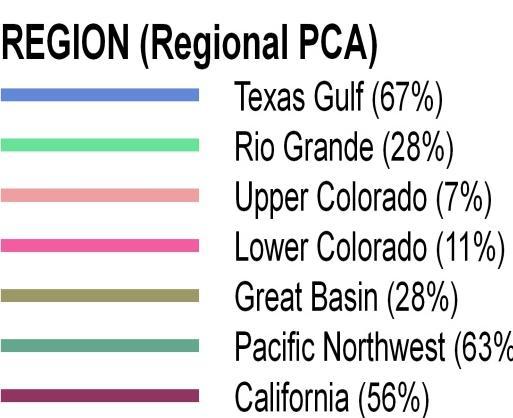
9 New National Representation of PCAs Final QA/QC 9
10 Metabolite Modeling with PRZM Formation phase kp*ffm*p>km*m where: kp=parent rate const. km=metab rate const. ffm=formation fraction of metabolite P=Amount of parent M=Amount of metab Substance (% of applied) Maximum kp*ffm*p=km*m Parent Decline phase km*m> kp*ffm*p Metabolite Time (days)
11 Metabolite Modeling with PRZM
12 PRZM-Based Modeling Tool for Groundwater with Canada Parameterized PRZM_GW for About 68 Compounds Used Most Recent DWA for Chemical Properties (Koc, Hydrolysis Half-lives, Aerobic Metabolism Half-lives) Maximum Application Rate Modeled Each Compound for Each of Seven Scenarios Delmarva, FL Citrus, FL Potato, GA peanuts, NC Cotton, WI Corn, ID Potato Compared Output to NAWQA Observed Peak Values
NatureServe s Federally Listed Species Location Data Play an Important Role in EPA s FIFRA Risk Assessments
 NatureServe s Federally Listed Species Location Data Play an Important Role in EPA s FIFRA Risk Assessments 1 ASHLEA FRANK COMPLIANCE SERVICES INTERNATIONAL FIFRA ENDANGERED SPECIES TASK FORCE BIODIVERSITY
FESTF Gopher. A Data Integration Tool to Inform Decisions in FIFRA/ESA Processes
 FESTF Gopher A Data Integration Tool to Inform Decisions in FIFRA/ESA Processes April 26, 2018 CropLife America & RISE Regulatory Conference Arlington, VA An Introduction to FESTF The (FESTF), incorporated
GROUNDWATER EXPOSURE ASSESSMENT FOR WOOD PRESERVATIVES
 GROUNDWATER EXPOSURE ASSESSMENT FOR WOOD PRESERVATIVES (SOIL STUDIES APPLICABILITY FOR MOBILE OR PERSISTENT SUBSTANCES AND DT 50 /K OC INPUT VALUES FOR PELMO/PEARL MODELS) This document was agreed upon
What is a watershed or landscape perspective?
 What is a watershed or landscape perspective? -remove sediment -add sediment -add wood, riparian manipulation -alter (engineer) channel/floodplain morphology -restore/abandon roads You are here What is
Creating A-16 Compliant National Data Theme for Cultural Resources
 Creating A-16 Compliant National Data Theme for Cultural Resources Cultural Resource GIS Facility National Park Service John J. Knoerl Deidre McCarthy Paper 169 Abstract OMB Circular A-16 defines a set
Application of SADA for 3D Subsurface Characterization and Suggested Approach for Volumetric Compliance with Decommissioning Dose Criteria
 Application of SADA for 3D Subsurface Characterization and Suggested Approach for Volumetric Compliance with Decommissioning Dose Criteria Robert Stewart, Ph.D. Oak Ridge National Laboratory University
Using the simulation error in lysimeter evaluations. Anja Verschoor, Jos Boesten, Minze Leistra, Ton van der Linden, Jan Linders, Werner Pol.
 Using the simulation error in lysimeter evaluations Anja Verschoor, Jos Boesten, Minze Leistra, Ton van der Linden, Jan Linders, Werner Pol. Introduction Lysimeter/field studies are higher tier studies
Regulation of Agricultural Biotechnology in the United States: Role of USDA-APHIS Biotechnology Regulatory Services
 Regulation of Agricultural Biotechnology in the United States: Role of USDA-APHIS Biotechnology Regulatory Services Bill Doley USDA-APHIS-BRS October 24, 2016 Regulation Under the Coordinated Framework
- A7/13 - PART 2. Matrix Analyte(s) Method LOQ Reference. HPLC with fluorescence detection after acid hydrolysis
 Method LOQ Reference. HPLC with fluorescence detection after acid hydrolysis") - A7/1 - Appendix 7 Format for the Compilation of Tier II Summaries - Active substance PART Section Analytical methods The example of a summary and assessment of data which follows is intended to illustrate
- A7/1 - Appendix 7 Format for the Compilation of Tier II Summaries - Active substance PART Section Analytical methods The example of a summary and assessment of data which follows is intended to illustrate
2016 NC Coastal Local Governments Annual Meeting
 6 NC Coastal Local Governments Annual Meeting NCFMP Coastal Map Maintenance Flood Study Updates and Changes April, 6 Tom Langan, PE, CFM Engineering Supervisor NCEM-Risk Management - Floodplain Mapping
Understanding DWAs in First Nations Systems A Data Mining Approach
 Understanding DWAs in First Nations Systems A Data Mining Approach Emma Thompson E. McBean, Y. Post 65 percent of First Nations experienced a Drinking Water Advisory (DWA) between 2004 2014. The federal
Environmental Toxicology of 2,4-D
 Environmental Toxicology of 2,4-D Environmental toxicology includes terrestrial wildlife and plants, and aquatic wildlife and plants. Exposures of wildlife to 2,4-D, whether from direct spraying or consumption
1) NetMap Overview. 2) Habitat modeling HIP & Beyond. 3) What do you do with habitat models? 4) NetMap a platform for regional analysis & interactions
 NetMap Overview. 2) Habitat modeling HIP & Beyond. 3) What do you do with habitat models? 4) NetMap a platform for regional analysis & interactions") 1) NetMap Overview 2) Habitat modeling HIP & Beyond 3) What do you do with habitat models? 4) NetMap a platform for regional analysis & interactions Overview Multiple analysis tools Creates universal stream/hillslope
1) NetMap Overview 2) Habitat modeling HIP & Beyond 3) What do you do with habitat models? 4) NetMap a platform for regional analysis & interactions Overview Multiple analysis tools Creates universal stream/hillslope
GIS ADMINISTRATOR / WEB DEVELOPER EVANSVILLE-VANDERBURGH COUNTY AREA PLAN COMMISSION
 GIS ADMINISTRATOR / WEB DEVELOPER EVANSVILLE-VANDERBURGH COUNTY AREA PLAN COMMISSION SALARY RANGE INITIATION $43,277 SIX MONTHS $45,367 POSITION GRADE PAT VI The Evansville-Vanderburgh County Area Plan
EPA's Revision to the 40 CFR Part 136 Method Detection Limit (MDL) Procedure
 Procedure") Ask The Expert Webinar Series EPA's Revision to the 40 CFR Part 136 Method Detection Limit (MDL) Procedure Richard Burrows, Ph.D. Corporate Technical Director A Revision to the Method Detection Limit EPA
Ask The Expert Webinar Series EPA's Revision to the 40 CFR Part 136 Method Detection Limit (MDL) Procedure Richard Burrows, Ph.D. Corporate Technical Director A Revision to the Method Detection Limit EPA
Downtown Anchorage Seismic Risk Assessment & Land Use Regulations to Mitigate Seismic Risk
 Prepared for: The Municipality of Anchorage Planning Department and the Geotechnical Advisory Commission Downtown Anchorage Seismic Risk Assessment & Land Use Regulations to Mitigate Seismic Risk Prepared
Environmental Risk Assessment of Nanomedicines
 Environmental Risk Assessment of Nanomedicines Specific methodological issues and implications for risk assessment Silvia Berkner, Petra Apel Umweltbundesamt, Germany Outline Regulatory background Current
NCAVES - Global initiative and national pilots
 NCAVES - Global initiative and national pilots Kavita Sharma UN Environment Pretoria, March 2018 Outline 1. Global initiative > Introduction > Objectives and deliverables >Activities in 2017 and 2018 2.
FEMA Hazards Loss Modeling Task Force (MOTF) Situation Report #14. Colorado Spring Flood Risk ***FINAL REPORT***
 Situation Report #14. Colorado Spring Flood Risk ***FINAL REPORT***") FEMA Hazards Loss Modeling Task Force (MOTF) Situation Report #14 Colorado Spring Flood Risk FEMA Modeling Task Force (MOTF) Denver Federal Center, Building 710A Denver, Colorado 80225 Email: FEMA-MOTF@fema.dhs.gov
FEMA Hazards Loss Modeling Task Force (MOTF) Situation Report #14 Colorado Spring Flood Risk FEMA Modeling Task Force (MOTF) Denver Federal Center, Building 710A Denver, Colorado 80225 Email: FEMA-MOTF@fema.dhs.gov
Combining Geospatial and Statistical Data for Analysis & Dissemination
 Combining Geospatial and Statistical Data for Analysis & Dissemination (with Special Reference to Qatar Census 2010) Presentation by Mansoor Al Malki, Director of IT Department Qatar Statistics Authority
European Chemicals Agency (ECHA)Topical Scientific Workshop: Regulatory Challenges in Risk Assessment of Nanomaterials
Topical Scientific Workshop: Regulatory Challenges in Risk Assessment of Nanomaterials") European Chemicals Agency (ECHA)Topical Scientific Workshop: Regulatory Challenges in Risk Assessment of Nanomaterials Jim Alwood - Office of Pollution Prevention and Toxics October 23, 2014 Legislation
European Chemicals Agency (ECHA)Topical Scientific Workshop: Regulatory Challenges in Risk Assessment of Nanomaterials Jim Alwood - Office of Pollution Prevention and Toxics October 23, 2014 Legislation
Space Application in Support of Land Management for SDG Implementation
 Space Application in Support of Land Management for SDG Implementation Regional Expert Workshop on Land Accounting for SDG Monitoring and Reporting 26 September 2017 Space Application Section Information
Digital Wetlands. Bringing the Field into the Office Through GIS
 Digital Wetlands Bringing the Field into the Office Through GIS Maryland Department of the Environment Wetlands and Waterways Program MDE's Wetlands and Waterways Program seeks to conserve valuable aquatic
Spatially Distributed Models: A Step Forward in Higher Tier Leaching Studies. Aaldrik Tiktak
 Spatially Distributed Models: A Step Forward in Higher Tier Leaching Studies Aaldrik Tiktak Outline of presentation The role of spatially distributed models The GeoPEARL model Three Cases Conclusions &
GIS-Based Sediment Quality Database for the St. Louis River Area of Concern (AOC): Overview Presentations and Demonstration
: Overview Presentations and Demonstration") GIS-Based Sediment Quality Database for the St. Louis River Area of Concern (AOC): Overview Presentations and Demonstration Judy L. Crane 1 and Dawn E. Smorong 2 1 Minnesota Pollution Control Agency, St.
GIS-Based Sediment Quality Database for the St. Louis River Area of Concern (AOC): Overview Presentations and Demonstration Judy L. Crane 1 and Dawn E. Smorong 2 1 Minnesota Pollution Control Agency, St.
Spatial modeling of pesticide emissions to groundwater and surface water in the Belgian context
 11/10/2012 Spatial modeling of pesticide emissions to groundwater and surface water in the Belgian context Bernhard s e-mail : 30 minutes => 20 minutes + 10 minutes discussion and award for best debater!
New Policies on Chemical Environmental Management in China. Gao Yingxin Chemical Registration Center of MEP September 9, 2010
 New Policies on Chemical Environmental Management in China Gao Yingxin Chemical Registration Center of MEP September 9, 2010 Measures on Environmental Management of New Chemical Substances Strengthened
Project Primary Contact: Gregg Servheen, Idaho Department of Fish and Game, PO Box 25 Boise, ID ,
 Project Title: Idaho Montana Divide Project Objective: Pilot the conceptualization and coordination of a transboundary Decision Support System(DSS) for fish, wildlife, and habitats along the Idaho Montana
Identification of Very Shallow Groundwater Regions in the EU to Support Monitoring
 Identification of Very Shallow Groundwater Regions in the EU to Support Monitoring Timothy Negley Paul Sweeney Lucy Fish Paul Hendley Andrew Newcombe ARCADIS Syngenta Ltd. Syngenta Ltd. Phasera Ltd. ARCADIS
Operational water balance model for Siilinjärvi mine
 Operational water balance model for Siilinjärvi mine Vesa Kolhinen, Tiia Vento, Juho Jakkila, Markus Huttunen, Marie Korppoo, Bertel Vehviläinen Finnish Environment Institute (SYKE) Freshwater Centre/Watershed
SADA General Information
 SADA General Information Windows--based freeware designed to integrate scientific models with decision and cost analysis frameworks in a seamless, easy to use environment. Visualization/GIS Custom Analysis
Arizona Division of Occupational Safety and Health Administration. 800 W. Washington Street, Phoenix, AZ Consultation:
 ADOSH Arizona Division of Occupational Safety and Health Administration 800 W. Washington Street, Phoenix, AZ 85007 Consultation: 602-542-1769 GLOBALLY HARMONIZED SYSTEM for HAZARD COMMUNICATION Steven
Regional Variability in Crop Specific Synoptic Forecasts
 Regional Variability in Crop Specific Synoptic Forecasts Kathleen M. Baker 1 1 Western Michigan University, USA, kathleen.baker@wmich.edu Abstract Under climate change scenarios, growing season patterns
Chesapeake Bay Remote Sensing Pilot Executive Briefing
 Chesapeake Bay Remote Sensing Pilot Executive Briefing Introduction In his Executive Order 13506 in May 2009, President Obama stated The Chesapeake Bay is a national treasure constituting the largest estuary
Status of the Implementation of GHS in China
 Status of the Implementation of GHS in China Content Law and regulation system of chemical management Institutions Implementing GHS in China Management on the Import and Export of Chemicals Problems and
Updated Precipitation Frequency Estimates for Minnesota
 1 Updated Precipitation Frequency Estimates for Minnesota Presenter: Authors: (alphabetical order) Sanja Perica, Director Hydrometeorological Design Studies Center (HDSC), Office of Hydrology, National
A New National Flood Inundation Mapping Science Initiative
 A New National Flood Inundation Mapping Science Initiative William Guertal, PhD. Director, USGS Indiana and Kentucky Water Science Centers U.S. Department of the Interior U.S. Geological Survey Courtesy
Biological Response to the Gold King Mine Release in the Animas and San Juan Rivers
 Biological Response to the Gold King Mine Release in the and San Juan Rivers Lareina Guenzel 1, Richard Mitchell, PhD 1, Kate Sullivan, PhD 2, and Michael Cyterski, PhD 2 1 U.S. Environmental Protection
HACCP Concept. Overview of HACCP Principles. HACCP Principles. Preliminary Tasks Development of the HACCP Plan
 HACCP Concept Overview of HACCP Principles A systematic approach to be used in food production as a means to assure food safety. National Advisory Committee on Microbiological Criteria for Foods (NACMCF)
SCIENTIFIC OPINION. EFSA Panel on Plant Protection Products and their Residues 2, 3. European Food Safety Authority (EFSA), Parma, Italy
, Parma, Italy") EFSA Journal 2011;volume(issue):NNNN 1 2 3 4 5 6 SCIENTIFIC OPINION Draft Scientific Opinion on the science behind the guidance for scenario selection and scenario parameterisation for predicting environmental
EFSA Journal 2011;volume(issue):NNNN 1 2 3 4 5 6 SCIENTIFIC OPINION Draft Scientific Opinion on the science behind the guidance for scenario selection and scenario parameterisation for predicting environmental
ArcGIS Online Tools and Water-Related Web Services You Can Use Every Day of Your Life!
 ArcGIS Online Tools and Water-Related Web Services You Can Use Every Day of Your Life! Brian Rowley, PE, CFM FMA 2014 Annual Conference 1 Gold Rush (49ers) John Sutter Sutter s Mill South fork of American
Overview of HACCP Principles. OFFICE OF THE TEXAS STATE CHEMIST Texas Feed and Fertilizer Control Service Agriculture Analytical Service
 Overview of HACCP Principles OFFICE OF THE TEXAS STATE CHEMIST Texas Feed and Fertilizer Control Service Agriculture Analytical Service OFFICE OF THE TEXAS STATE CHEMIST 2 HACCP Concept A systematic approach
NEW YORK STATE WATER RESOURCES INSTITUTE Department of Biological and Environmental Engineering
 NEW YORK STATE WATER RESOURCES INSTITUTE Department of Biological and Environmental Engineering 230 Riley-Robb Hall, Cornell University Tel: (607) 254-7163 Ithaca, NY 14853-5701 Fax: (607) 255-4080 http://wri.cals.cornell.edu
Everything NENA: GIS Data Standards, the NEAD, and the NG9-1-1 Act of 2017
 Everything NENA: GIS Data Standards, the NEAD, and the NG9-1-1 Act of 2017 Cheryl Benjamin Richard Kelly NYS ITS GIS Program Office 911 Datamaster NSGIC liaison to NENA NENA liaison to NSGIC NENA Standard
Peter Kearns, PhD OECD, ENV/EHS BIPM, April 2015
 EXPOSURE MEASUREMENT AND EXPOSURE MITIGATION: ACTIVITIES OF OECD S WORKING PARTY ON MANUFACTURED NANOMATERIALS Peter Kearns, PhD OECD, ENV/EHS BIPM, April 2015 Areas covered by the OECD Programme Testing
Qatar Statistical Geospatial Integration
 Qatar Statistical Geospatial Integration A Presentation by the Ministry of Development Planning & Statistics (MDPS), State of Qatar http://www.mdps.gov.qa (Fourth UN-GGIM Arab States Committee Meeting,
OECD QSAR Toolbox v.4.1. Tutorial on how to predict Skin sensitization potential taking into account alert performance
 OECD QSAR Toolbox v.4.1 Tutorial on how to predict Skin sensitization potential taking into account alert performance Outlook Background Objectives Specific Aims Read across and analogue approach The exercise
CHAPTER 4 ENVIRONMENTAL FATE
 CHAPTER 4 ENVIRONMENTAL FATE Introduction This chapter serves as a basis to identify the hazards associated with different substances used and produced in the chemical process, including raw materials,
Source Protection Zones. National Dataset User Guide
 Source Protection Zones National Dataset User Guide Version 1.1.4 20 th Jan 2006 1 Contents 1.0 Record of amendment...3 2.0 Introduction...4 2.1 Description of the SPZ dataset...4 2.1.1 Definition of the
Fate, Transport and Transformation Test Guidelines OPPTS Hydrolysis
 United States Environmental Protection Agency Prevention, Pesticides And Toxic Substances (7101) Fate, Transport and Transformation Test Guidelines OPPTS 835.2120 Hydrolysis EPA 712-C-08-012 October 2008
Reducing Vulnerability to Extreme Heat: Science-Policy Interface
 Reducing Vulnerability to Extreme Heat: Science-Policy Interface Olga Wilhelmi, Mary Hayden, Jennifer Boehnert, Ursula Lauper and SIMMER research team October 23, 2013 Toronto SIMMER workshop Science-Policy
Sodium Hypochlorite Solution, 10-16%
 Chemical Identity Product Safety Summary for Sodium Hypochlorite Solution, 10-16% Name: Sodium Hypochlorite CAS number: 7681-52-9 Synonyms: Bleach, Hypo Chemical Formula: NaOCl Product Uses Trinity Manufacturing,
Implementation Status & Results Indonesia Improving Governance for Sustainable Indigenous Community Livelihoods in Forested Areas (P130632)
") Public Disclosure Authorized Public Disclosure Authorized The World Bank Implementation Status & Results Indonesia Improving Governance for Sustainable Indigenous Community Livelihoods in Forested Areas
Public Disclosure Authorized Public Disclosure Authorized The World Bank Implementation Status & Results Indonesia Improving Governance for Sustainable Indigenous Community Livelihoods in Forested Areas
Date of Report: EPA agreement number: Center Name and Institution of Ctr. Director: Identifier used by Center for Project: Title of Project:
 Date of Report: March 31, 2003 EPA agreement number: R829515C003 Center Name and Institution of Ctr. Director: Rocky Mountain Regional Hazardous Substance Research Center, Colorado State University, Fort
Geospatial Data, Services, and Products. National Surveying, mapping and geospatial conference
 Geospatial Data, Services, and Products Federal Programs -- USDA NRCS National Surveying, mapping and geospatial conference March 15, 2016 NRCS Applications using Geosaptial Products & Services Field
NC Streambed Mapping Project Issue Paper
 ISSUE 1: The Western North Carolina Drainage Area Requirement Issue Several inquiries and discussions in regard to the determination of the 6-acre drainage area requirement as the upstream limit have been
OECD QSAR Toolbox v.3.4. Example for predicting Repeated dose toxicity of 2,3-dimethylaniline
 OECD QSAR Toolbox v.3.4 Example for predicting Repeated dose toxicity of 2,3-dimethylaniline Outlook Background Objectives The exercise Workflow Save prediction 2 Background This is a step-by-step presentation
The production and use of a hydrographic flow-direction network of surface waters. Rickard HALLENGREN, Håkan OLSSON and Erik SISELL, Sweden
 The production and use of a hydrographic flow-direction network of surface waters Rickard HALLENGREN, Håkan OLSSON and Erik SISELL, Sweden Key words: hydrographic, flow-direction network, surface waters
Controlled Substances: TSCA the Toxic Substances Control Act
 The select agent list and relevant regulatory program information are maintained by the CDC and can be found on the select agent web site http://www.selectagents.gov/. The regulations covering select agents
Colorado River Management under Uncertainty
 Colorado River Management under Uncertainty Terry Fulp Deputy Regional Director Lower Colorado Region WRRC Annual Meeting June 24, 2008 Colorado River Management under Uncertainty Overview of Colorado
Risk Management under the. Chemicals Management Plan
 Risk Management under the Population Exposure Assessment Chemicals Management Plan Approaches and Tools for Health Risk Assessment under CMP Stakeholder Advisory Council meeting Health Canada PAHO Workshop
Groundwater Vulnerability Mapping Eastern Newfoundland Executive Summary
 Groundwater Vulnerability Mapping Eastern Newfoundland Executive Summary 123102.00 Executive Summary March 2014 ISO 9001 Registered Company Prepared for: Water Resources Management Division Department
SAMPLE CHAPTERS UNESCO EOLSS ENVIRONMENTAL GEOCHEMISTRY. Peggy A. O Day Arizona State University, Tempe, AZ, USA
 ENVIRONMENTAL GEOCHEMISTRY Peggy A. O Day Arizona State University, Tempe, AZ, USA Keywords: environmental geochemistry, time and space scales, chemical principles, equilibrium thermodynamics. Kinetics
A S U M M A RY OF Chemigation Applicatio n Studies
 A S U M M A RY OF Chemigation Applicatio n Studies I n t r o d u c t i o n The incidence and impact of spray drift can be minimized by proper equipment selection and setup, and good application technique.
REACH. Federation of Hong Kong Industries 17 th January, Heribert Bürgy Chemical Division Market Control and Advice
 Federal Department of Home Affairs FDHA Federal Office of Public Health FOPH Consumer Protection Directorate Federation of Hong Kong Industries 17 th January, 2008 Chemical Division Market Control and
Larry R. Glass, Ph.D., M.P.H. Xerox Corporation
 REACH COMPLIANCE LSS Project Registration Of Chemicals Evaluation Authorization & Restriction Larry R. Glass, Ph.D., M.P.H. Xerox Corporation Overview of REACH Regulation European Regulation Signed into
Overdracht van terrein informatie dmv een GIS internettoepassing bij de OVAM
 1 1. General Introduction... 2 1.1. GIS.... 2 1.1.1. What is a GIS?... 2 1.1.2. The Philosophy of a GIS... 2 1.1.3. Aspects of a GIS project... 3 1.1.4. Intergraph and GeoMedia... 4 1.2. OVAM... 5 1.2.1.
Product Properties Test Guidelines OPPTS Dissociation Constants in Water
 United States Environmental Protection Agency Prevention, Pesticides and Toxic Substances (7101) EPA 712 C 96 036 August 1996 Product Properties Test Guidelines OPPTS 830.7370 Dissociation Constants in
Maggie M. Kovach. Department of Geography University of North Carolina at Chapel Hill
 Maggie M. Kovach Department of Geography University of North Carolina at Chapel Hill Rationale What is heat-related illness? Why is it important? Who is at risk for heat-related illness and death? Urban
SRJC Applied Technology 54A Introduction to GIS
 SRJC Applied Technology 54A Introduction to GIS Overview Lecture of Geographic Information Systems Fall 2004 Santa Rosa Junior College Presented By: Tim Pudoff, GIS Coordinator, County of Sonoma, Information
Sea Level Rise and Hurricane Florence storm surge research methodology
 Sea Level Rise and Hurricane Florence storm surge research methodology Hurricane Florence storm surge analysis was conducted using a variety of input sources. In order to determine the maximum storm surge
Rainfall-River Forecasting: Overview of NOAA s Role, Responsibilities, and Services
 Dr. Thomas Graziano Chief Hydrologic Services Division NWS Headquarters Steve Buan Service Coordination Hydrologist NWS North Central River Forecast Center Rainfall-River Forecasting: Overview of NOAA
EVALUATION OF PEANUT DISEASE DEVELOPMENT FORECASTING. North Carolina State University, Raleigh, North Carolina
 P244 EVALUATION OF PEANUT DISEASE DEVELOPMENT FORECASTING John A. McGuire* 1, Mark S. Brooks 1, Aaron P. Sims 1, Barbara Shew 2, and Ryan Boyles 1 1 State Climate Office of North Carolina, 2 Department
Extrapolating New Approaches into a Tiered Approach to Mixtures Risk Assessment
 Extrapolating New into a Tiered Approach to Mixtures Risk Assessment Michael L. Dourson, PhD, DABT, FATS, FSRA Toxicology Excellence for Risk Assessment (TERA) dourson@tera.org Conflict of Interest Statement
GIS APPLICATIONS IN SOIL SURVEY UPDATES
 GIS APPLICATIONS IN SOIL SURVEY UPDATES ABSTRACT Recent computer hardware and GIS software developments provide new methods that can be used to update existing digital soil surveys. Multi-perspective visualization
Document Title. Estimating the Value of Partner Contributions to Flood Mapping Projects. Blue Book
 Document Title Estimating the Value of Partner Contributions to Flood Mapping Projects Blue Book Version 1.1 November 2006 Table of Contents 1. Background...1 2. Purpose...1 3. Overview of Approach...2
COMBINING ENUMERATION AREA MAPS AND SATELITE IMAGES (LAND COVER) FOR THE DEVELOPMENT OF AREA FRAME (MULTIPLE FRAMES) IN AN AFRICAN COUNTRY:
 FOR THE DEVELOPMENT OF AREA FRAME (MULTIPLE FRAMES) IN AN AFRICAN COUNTRY:") COMBINING ENUMERATION AREA MAPS AND SATELITE IMAGES (LAND COVER) FOR THE DEVELOPMENT OF AREA FRAME (MULTIPLE FRAMES) IN AN AFRICAN COUNTRY: PRELIMINARY LESSONS FROM THE EXPERIENCE OF ETHIOPIA BY ABERASH
COMBINING ENUMERATION AREA MAPS AND SATELITE IMAGES (LAND COVER) FOR THE DEVELOPMENT OF AREA FRAME (MULTIPLE FRAMES) IN AN AFRICAN COUNTRY: PRELIMINARY LESSONS FROM THE EXPERIENCE OF ETHIOPIA BY ABERASH
OECD QSAR Toolbox v.3.0
 OECD QSAR Toolbox v.3.0 Step-by-step example of how to categorize an inventory by mechanistic behaviour of the chemicals which it consists Background Objectives Specific Aims Trend analysis The exercise
Module 3 Indicator Land Consumption Rate to Population Growth Rate
 Regional Training Workshop on Human Settlement Indicators Module 3 Indicator 11.3.1 Land Consumption Rate to Population Growth Rate Dennis Mwaniki Global Urban Observatory, Research and Capacity Development
Reflection paper on poorly extractable and/or nonradiolabelled
 1 2 3 12 March 2015 EMA/CVMP/ERA/349254/2014 Committee of Veterinary Medicinal Products (CVMP) 4 5 6 Reflection paper on poorly extractable and/or nonradiolabelled substances Draft agreed by ERAWP January
April 10, Mr. Curt Van De Walle, City Manager City of Castle Hills 209 Lemonwood Drive Castle Hills, Texas 78213
 Mr. Curt Van De Walle, City Manager City of Castle Hills 209 Lemonwood Drive Castle Hills, Texas 78213 Subject: Revised Castle Hills BASIS Charter School Traffic Impact Analysis Review City of Castle Hills,
OECD QSAR Toolbox v.3.4
 OECD QSAR Toolbox v.3.4 Predicting developmental and reproductive toxicity of Diuron (CAS 330-54-1) based on DART categorization tool and DART SAR model Outlook Background Objectives The exercise Workflow
NEEA Refresh aka 3D Nation Requirements and Benefits Study. Allyson Jason, Carol Ostergren, Xan Fredericks and Lou Driber November 9, 2017
 + NEEA Refresh aka 3D Nation Requirements and Benefits Study Allyson Jason, Carol Ostergren, Xan Fredericks and Lou Driber November 9, 2017 + 2 Study Context Background The National Enhanced Elevation
Terms of Reference for the Comparative Environmental Review (CER) of. Options for the Mactaquac Project, Mactaquac, New Brunswick
 of. Options for the Mactaquac Project, Mactaquac, New Brunswick") Terms of Reference for the Comparative Environmental Review (CER) of Options for the Mactaquac Project, Mactaquac, New Brunswick Preamble The New Brunswick Power Corporation ( NB Power ) operates the Mactaquac
Terms of Reference for the Comparative Environmental Review (CER) of Options for the Mactaquac Project, Mactaquac, New Brunswick Preamble The New Brunswick Power Corporation ( NB Power ) operates the Mactaquac
Fact sheet on Intermediates under REACH
 Fact sheet on Intermediates under REACH April 2008 1. Introduction The REACh Regulation recognises intermediates as a distinct subset of substances that may either be able to benefit from a reduced registration
WRTM and Active Transportation and Demand Management
 The Future of Transportation - 2010 APWA Annual Congress and Exposition WRTM and Active Transportation and Demand Management Weather Responsive Traffic Management Workshop October 7, 2011 Jim Hunt F d
Arctic Spatial Data Infrastructure Enabling Access to Arctic Location-Based Information
 Arctic Spatial Data Infrastructure Enabling Access to Arctic Location-Based Information Arctic SDI Side Event Co-Chairs: Arvo Kokkonen Arctic SDI Board Chair & Director General, National Land Survey of
2,4-D Update. This document is published by the Health Canada Pest Management Regulatory Agency. For further information, please contact:
 Re-evaluation Note REV2017-08 2,4-D Update (publié aussi en français) 27 July 2017 This document is published by the Health Canada Pest Management Regulatory Agency. For further information, please contact:
why open access publication of stability date is essential Mark Santillo Regional QA Officer SW England
 why open access publication of stability date is essential Mark Santillo Regional QA Officer SW England } Standards for stability testing and data interpretation } Considerations for small molecule antimicrobials
Regulatory use of (Q)SARs under REACH
SARs under REACH") Regulatory use of (Q)SARs under REACH Webinar on Information requirements 10 December 2009 http://echa.europa.eu 1 Using (Q)SAR models Application under REACH to fulfill information requirements Use of
Regulatory use of (Q)SARs under REACH Webinar on Information requirements 10 December 2009 http://echa.europa.eu 1 Using (Q)SAR models Application under REACH to fulfill information requirements Use of
DFO Maritimes Region Update. Gulf of Maine Council - Coastal and Marine Spatial Planning (CMSP) Committee Web-Ex May 16, 2017
 Committee Web-Ex May 16, 2017") DFO Maritimes Region Update Gulf of Maine Council - Coastal and Marine Spatial Planning (CMSP) Committee Web-Ex May 16, 2017 1 National Oceans Priorities Marine Conservation Targets Oceans Protection Plan
DFO Maritimes Region Update Gulf of Maine Council - Coastal and Marine Spatial Planning (CMSP) Committee Web-Ex May 16, 2017 1 National Oceans Priorities Marine Conservation Targets Oceans Protection Plan
EnviroAtlas: An Atlas about Ecosystems and their Connection with People
 EnviroAtlas: An Atlas about Ecosystems and their Connection with People Annie Neale, Megan Mehaffey & Atlas Team ASWM Webinar October, 17 th, 2012 What is it? The Atlas is an online decision support tool
Brian McGurk, P.G. DEQ Office of Water Supply. Contents. Overview of Virginia s Drought Assessment & Response Plan
 Drought Preparedness in Virginia Or, Whatcha Gonna Do When the Well, Creek, River, or Reservoir (Might) Run Dry? Rappahannock-Rapidan Regional Commission Living Lands Workshop November 18, 2014 Brian McGurk,
Leveraging Your Geo-spatial Data Investments with Quantum GIS: an Open Source Geographic Information System
 Leveraging Your Geo-spatial Data Investments with Quantum GIS: an Open Source Geographic Information System Donald L. Schrupp Colorado Division of Wildlife (Retired) Danny Lewis Texas Parks and Wildlife
Statewide Topographic Mapping Program
 Statewide Topographic Mapping Program February 28, 2018 www.dotd.la.gov Outline Purpose of the Statewide Topographic Mapping Program History Breakdown of R.S. 48:36 - Topographic Mapping Statewide Topographic
Crop / Weather Update
 Crop / Weather Update Corn Crop Condition Percent of Acreage Rated Good or Excellent 85 80 75 70 65 60 55 50 45 The U.S. corn crop was rated 69% good-to-excellent on September 23, up 1% from week-ago,
New COST Action: Towards a European Network on Chemical Weather Forecasting and Information Systems
 New COST Action: Towards a European Network on Chemical Weather Forecasting and Information Systems Proposer: Mikhail Sofiev Finnish Meteorological Institute Historical background EUMETNET Workshop on
A Summary of State DOT GIS Activities. Presented at the 2000 AASHTO GIS-T Symposium Minneapolis, MN
 A Summary of State DOT GIS Activities Presented at the 2000 AASHTO GIS-T Symposium Minneapolis, MN Information Sources E-mail survey of state DOT GIS managers 49 State DOTs responded in 2000 Results compared
POINT SOURCES OF POLLUTION: LOCAL EFFECTS AND IT S CONTROL Vol. II - Contaminant Fate and Transport Process - Xi Yang and Gang Yu
 CONTAMINANT FATE AND TRANSPORT PROCESS Xi Yang and Gang Yu Department of Environmental Sciences and Engineering, Tsinghua University, Beijing, P. R. China Keywords: chemical fate, physical transport, chemical
Washington State K 12 Facilities Pre-Disaster Mitigation Program Final Mitigation Plan
 Washington State K 12 Facilities Pre-Disaster Mitigation Program Final Mitigation Plan ESD Meeting, January 2015 Office of Superintendent of Public Instruction School Facilities & Organization 1 Mitigating