IRENA Indicator Fact Sheet IRENA indicator 29 Soil quality
|
|
|
- Sharlene Banks
- 6 years ago
- Views:
Transcription


1 Indicator Definition Topsoil (0-30cm) organic carbon content Input Indicator links: IRENA 24 - Land cover change Output Indicator Links: IRENA 23 - Soil erosion Key message Soil quality cannot be measured directly. For the EU, soil organic carbon content in topsoil has been defined as the more appropriate indicator for soil quality. High organic carbon content corresponds to good soil conditions from an agro-environmental point of view: limited soil erosion, high buffering and filtration capacity, rich habitat for soil organisms, enhanced sink for atmospheric carbon dioxide, etc.. Soils with Organic Carbon content between 1 and 10 % can also be considered of high agricultural value, while soils with less the 1% can be considered as affected by severe degradation (desertification). Peat and peaty soils should be considered separately in this context. Figure 29.1 Estimated organic carbon content (%) in the surface horizon (0-30 cm) of soils in Europe Source: Joint Research Centre,
2 Results and assessment Introduction SOIL QUALITY is how well soil does what we want it to do. More specifically, soil quality is the capacity of a specific kind of soil to function, within natural or managed ecosystem boundaries, to sustain plant and animal productivity, maintain or enhance water and air quality, and support human health and habitation (USDA, A definition of soil quality for the purposes of the EU is lacking. Nevertheless the Commission has put forward a number of criteria (COM 179 (2002)) for defining well functioning soils from the European perspective. Four out of five functions are directly linked to soil organic carbon content: food and biomass production, filtering and buffering capacity, pool of biodiversity and source of raw materials (peat). Therefore the levels of soil organic carbon in topsoil have been adopted as the more appropriate indicator for soil quality for agro-environmental purposes, since it covers both strictly agricultural criteria and wider environmental concerns. A new important aspect related to soil organic carbon is the recognition of the importance of the soil organic carbon pool in the context of the European Climate Change Programme ( Policy relevance and context The decline of soil organic carbon content has been identified by the Commission in COM 179 (2002) Towards a EU Thematic Strategy for Soil protection as one of the priority areas where immediate action is needed. The importance of organic carbon was as well recognised by the Council and the European Parliament in their position papers following the above communication. Council Regulation (EC) No. 1782/2003 of 29 September 2003 has set up the crosscompliance as compulsory measure from Farmers receiving direct payments must respect statutory standards in the fields of environment, food safety, and animal health and welfare at farm level. The beneficiaries of direct payments will also be obliged to maintain their agricultural land in good agricultural and environmental condition, in order to avoid deterioration of land and land abandonment. They will also have to maintain the share of land under permanent pasture. The main issues that Member States should addressed in the Good Agricultural and Environmental conditions are: soil erosion, decline of soil organic matter and physical soil degradation. This indicator addresses the second issue, the decline of soil organic carbon content. It will be necessary to further develop this indicator with a time component (soil monitoring) in order to detect impacts of soil protection measures. The need for a comprehensive approach for soil monitoring has been well recognised by the Commission in its communication and will be one of the main elements of the forthcoming EU Thematic Strategy for Soil Protection. Monitoring changes in Soil Organic Carbon content will be particularly relevant in the context of potential contribution of soils to the achievement of the Kyoto target. A mitigation potential of MtCO2-eq has been estimated (ECCP, 2003) provided by conservation and enhancement of carbon stocks by extensification (e.g. organic farming, conservation agriculture) and other Good Agricultural Practices. Agri-environmental Context The original definition of the soil quality indicator, as for example in COM(2001)144, was strictly linked to a mono-functional perspective on soil protection. COM (2002) 179 has clarified that in the EU soils are considered in their full multi-functionality. Therefore, soil quality, as previously defined, was not taking into account this new European perspective. Meanwhile also in other OECD countries (USDA, D.L. Karlen et al., Geoderma 114 (2003) ) a fundamental re-thinking of the soil quality concept is taking place. The close link between soil organic carbon and a number of related soil properties make it one of the best candidates as a newly defined soil quality indicator for Europe. Assessment Fig displays the data layer of continuous Soil Organic Carbon values grouped into 7 classes. The distribution has been validated against a number of National assessments, with good accordance. Areas in southern Europe with OC_TOP between 0 1% appear in the 2
3 expected places and correspond with areas with high soil erosion rates (see indicator 23). The organic soils (peat) in northern Europe are clearly highlighted. An estimated distribution of major classes of Organic Carbon in topsoil in Europe shows that 45% of the area covered by this assessment corresponds to soils with medium organic carbon content (good condition). Soils with low and very low organic carbon content account for ca. 45% and the rest is to be considered as organic soils (peat and peaty soils). A clear humidity and temperature trend is present, with soils in the dry and warm Mediterranean area suffering of low to very low organic carbon content. This corresponds to areas that have been recognised in other assessments related to indicators for desertification in the Mediterranean ( as areas highly sensitive to desertification processes. Of particular importance for assessing the potential of soils for mitigation strategies towards the Kyoto target are the aggregated results at National level (fig. 29.2) allowing a good estimate of the current carbon pools in European soils. Main single factor determining soil organic carbon content is land use. New land cover (CLC2000) and land use (LUCAS) data will allow monitoring soil organic carbon changes over time. 3
4 References IRENA Indicator Fact Sheet Arrouays, D., Deslais, W. and Badeau, V. (2001). The carbon content of topsoil and its geographical distribution in France. Soil Use and Management 17, Batjes, N.H. (1996). Total carbon and nitrogen in the soils of the world. European Journal of Soil Science 47, Bullock, P., Jones, R.J.A. and Montanarella, L. eds. (1999). (eds). Soil Resources of Europe. European Soil Bureau Research Report No.6, EUR EN, (1999), 202pp. Office for Official Publications of the European Communities, Luxembourg. CEC (1985). Soil Map of the European Communities, 1:1,000,000. CEC Luxembourg, 124pp, 7 maps. Daroussin, J. and King, D. (1997). A pedotransfer rules database to interpret the Soil Geographical Database of Europe for environmental purposes. In: The use of pedotransfer in soil hydrology research in Europe. A. Bruand, O. Duval, H. Wosten, A. Lilly (eds). European Soil Bureau Research Report No.3. EUR EN, INRA, Orleans, France. EC (2002). Communication of 16 April 2002 from the Commission to the Council, the European Parliament, the Economic and Social Committee and the Committee of the Regions - Towards a Thematic Strategy for Soil Protection [COM (2002) 179 final 35pp. Heineke, H.J., Eckelmann, W., Thomasson, A.J., Jones, R.J.A., Montanarella, L. and Buckley, B. (eds). (1998). Land Information Systems: Developments for planning the sustainable use of land resources. European Soil Bureau Research Report No.4, EUR EN, 546pp. Office for Official Publications of the European Communities, Luxembourg. Hiederer, R. (2001) European Catchment Information System for Agri-Environmental Issues. Proceedings of EuroConference Link GEO and Water Research Genoa - Italy, 7-9 February Howard, P.J.A., Loveland, P.J., Bradley, R.I., Dry, F.T., Howard, D.M. and Howard, D.C. (1995). The carbon content of soil and its geographical distribution in Great Britain. Soil Use and Management 11, King, D., Daroussin, J. and Tavernier, R. (1994). Development of a soil geographical database from the soil map of the European Communities. Catena 21, King, D., Jones, R.J.A. and Thomasson, A.J. (1995). European Land Information Systems for Agro-environmental Monitoring. EUR EN, 285pp. Office for Official Publications of the European Communities, Luxembourg. Jones, R.J.A, R. Hiederer, E. Rusco, P.J. Loveland and L. Montanarella (2003). Topsoil Organic Carbon in Europe. Proceedings of the 4th European Congress on Regional Geoscientific Cartography and Information Systems, Bologna, , p Jones, R.J.A. and Hollis, J.M. (1996). Pedotransfer rules for environmental interpretations of the EU Soil Database. In: Soil databases to support sustainable development. C. Le Bas and M.,Jamagne (eds). EUR EN, Commission of the European Communities and INRA-Orleans. Le Bas, C. and Jamagne, M. (1996). Soil databases to support sustainable development. European Research Report No.2. EUR EN, 149pp. Office for Official Publications of the European Communities, Luxembourg. Madsen, H. Breuning and Jones, R.J.A. (1995). Soil Profile Analytical Database for the European Union. Danish Journal of Geography, 95, McGrath, S.P. and Loveland, P.J. (1992). The Soil Geochemical Atlas of England and Wales. Blackie Academic and Professional, London, 101pp. Rusco, E., Jones, R.J.A. and Bidoglio, G. (2001). Organic matter in the soils of Europe: Present status and future trends. EUR EN, 14pp. Office for Official Publications of the European Communities, Luxembourg. 4
5 Rusco, E. (In preparation). Carbon sequestration in Italy. Research Report, European Soil Bureau, European Commission Joint Research Centre, Ispra, 85pp. Smith, P. Powlson, D.S., Smith, J.U., Falloon, P., and Coleman, K. (2000a). Meeting the UK s climate change commitments: options for carbon mitigation on agricultural land. Soil Use and Management 16, Smith, P. Powlson, D.S., Smith, J.U., Falloon, P., and Coleman, K. (2000b). Revised estimates of the carbon mitigation potential of UK agricultural land. Soil Use and Management 16, Van Ranst, E., Thomasson, A.J., Daroussin, J., Hollis, J.M., Jones, R.J.A., Jamagne, M., King, D. and Vanmechelen, L. (1995). Elaboration of an extended knowledge database to interpret the 1:1,000,000 EU Soil Map for environmental purposes. In: European Land Information Systems for Agro-environmental Monitoring. D. King, R.J.A. Jones and A.J. Thomasson (eds.). EUR EN, Office for Official Publications of the European Communities, Luxembourg. Data sources Soil: European Soil Database (Fig. 29.3) The European Soil Database v.1.0 (King et al., 1995; Le Bas and Jamagne, 1996; Heineke et al., 1998) has been constructed from source material prepared and published at a scale of 1:1,000,000 (CEC, 1985). The resulting soil data are harmonised for the whole area covered according to a standard international classification (FAO-UNESCO, 1974; FAO-UNESCO- ISRIC, 1990), together with analytical data for standard profiles (Madsen and Jones, 1995). The spatial component of this database comprises polygons, which represent Soil Mapping Units (SMUs). These spatial elements are linked to one or more Soil Typological Units (STUs). Attribute data exist for STUs and so these data can be related to SMUs. Although each STU is unambiguously defined through a single set of parameters, SMUs may contain up to eight STUs. The spatial location of STUs within an SMU is not known, only the proportion of each STU in the SMU. In addition, many of the attributes are not stored as measured values but as codes relating to classes. While the structure of the European Soil Database allows for relatively efficient data storage, it is not particularly well suited for spatial analysis in raster format or combining external information, and for applying mathematical functions rather than rule-based systems. Therefore, a specific set of raster layers was produced based on an area-weighted distribution of attributes within SMUs. In the process, class values were transferred to continuous numeric values. Spatial representation of attributes was improved by performing a multi-criteria analysis within each SMU based on STU characteristics. The procedure provided a set of thematic layers, in which each soil parameter is stored in a single layer using continuous values for representation. Land Use/Cover: CORINE LC and USGS Eurasia (Fig. 29.4) The land cover data were taken from a data set covering Europe with information according to the CORINE Land Cover (LC) classification codes. Since CORINE LC covers only part of the area of interest, land cover was supplemented with specifically adapted Eurasia land cover data, derived from a US Geological Survey (USGS) database, in areas, where CORINE data are absent. To achieve comparable thematic coverage between the CORINE and USGS data, a series of cross-classifications was carried out, using various USGS data layers and reassigning or merging classes where appropriate. The final layer corresponds to CORINE level 3 classification codes. Climate: GHCN (Fig. 29.5) Variations in soil OC with varying climatic conditions were taken into account by using the average annual accumulated temperature (AAAT), expressed in day deg C. The data used were derived from station observations as available through the Global Historical Climatology Network GHCN (Easterling et al., 1996). From the point data, spatial layers were derived through a weighted distance interpolation. The influence of station altitude on temperature 5


6 observations was adjusted for by applying an adapted moist adiabatic lapse rate. The period used in the study covered the years The period was chosen, because it precedes the collection of ground data. However, moisture was not included separately as a parameter in the PTRs because the influence of this soil-forming factor is implicitly taken into account with the inclusion of the parameter "SOIL" in the PTR. Since the indicator aims to produce baseline data, i.e. a data layer of existing OC content, rather than modelling soil development and carbon stocks, using external datasets to model the influence of soil moisture could make the model unnecessarily complex. Figure 29.2 European Soil Database at scale 1:1,000,000 6


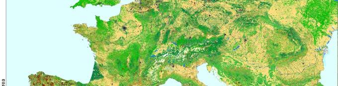


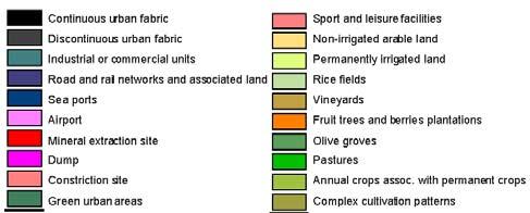
7 Figure 29.3 European Land Cover (R. Hiederer, 2002). 7
 computed")
8 Figure 29.4 Average annual accumulated temperature (AAAT) computed from GHCN temperature data. AAAT day deg C
9 Methodological approach The procedure adopted was to first compute the rule-based set relating soil type, texture and land cover to OC and then to apply a function defining the influence of temperature. For the information on the soil parameters the European Soil Database (V. 1.0) was used. For texture, land cover and temperature, external detailed data sets substitute the sometimes incomplete data in this version of the soil database. Pedo-transfer Rules Pedo-transfer rules (PTRs) form the main component in the processing methodology developed for this indicator. The PTRs used, including one series for estimating topsoil OC (OC_TOP), were constructed for environmental interpretations of the European Soil Database (Van Ranst et al., 1995). Daroussin and King, (1997) and Jones and Hollis (1996) describe the general methodology for applying these PTRs. The OC_TOP rules use 6 input parameters: three for soil, one each for texture, land use, temperature. A total of 150 conditions or rules are defined in this series. The common form of using such rules is to apply them to the STUs of the European Soil Database and to generate a new attribute for each SMU. Information on ancillary parameters, such as land use, is used as found in the database. This indicator employs the PTRs in a different way than previously. Firstly, the rules are not applied to STUs in a table, but calculations are performed on spatial data layers directly. Secondly, external data are used for land use and temperature. The first step was to analyse the existing PTRs for OC_TOP (as defined by Van Ranst et al., 1995) to remove ambiguity and establish a logically consistent sequential order. The logical order was generally confirmed but some of the conditions were found to be ambiguous. More important to the study was the absence of any rules for soils with high organic carbon content (>12%). The next step was to assess duplicity of the rules when removing the temperature parameter and to evaluate, if additional modifications were required. Additional rules were then added to cover soils with high organic content. The result was a revised set of 141 rules with 24 modifications of existing conditions or additions. The revised PTRs, using 5 parameters of soil type, texture and land cover, were converted into script code of the Idrisi32 GIS and applied to the spatial data layers. The layers for soil and texture originate from a raster version of the European Soil Database (v.1.0), while the land use layer comprised re-classified extended CORINE data. The procedure resulted in a base-line map of OC_TOP for Europe, derived from PTRs applied to the European Soil Database, using spatially detailed and complete land cover but excluding the influence of temperature. Temperature Effect The influence of temperature on OC_TOP content was taken into account using a function rather than a rule-based approach. The main reason for this modification was the relatively crude classification of accumulated temperature (3 classes) used in the original PTRs. The function was developed in accordance with the established principle that, within belts of uniform moisture conditions and comparable vegetation, the average total organic matter and nitrogen in soils increase by two to three times for each 10 C fall in mean temperature (Buckman and Brady, 1960, p.152). This is only a very general relationship but it was thought to be suitable for a basic Pan-European indicator. Accordingly, the average annual accumulated temperature (AAAT) in Europe was computed for the reference period The relationship between AAAT (taaat) and temperature correction coefficient (TEMPcor) was defined by a sigmoidal function of the type: n ( t ) c TEMPcor = f * cos AAAT + The correction factor, (TEMPcor), was set to values between 0.5 and 1.8. At 4000 day C, TEMPcor = 1.0, i.e. the organic carbon values produced by the revised PTRs for soil and land use remain unchanged. Such AAAT values occur for example in southern England, northern 9
10 France and southern Germany. The TEMPcor reached 0.5 for areas in southern Europe with AAAT in the range 6500 to 7000 day C, which is in accordance with the observed increase in OC_TOP with an increase in average annual temperature of about 10 C. The maximum TEMPcor = 1.8, which corresponds to an AAAT of 1800 day C. Temperatures as low as this are experienced in northern Europe and in Alpine regions. The resulting function is depicted in Figure TEMPERATURE CORRECTION FOR OC Ceofficient for temperature variation (> 3 ground measurements) Correction Factor Temperature Range (AAAT deg. C) Semi-natural Cultivated Avg. Ground Data Model Figure 29.6 Correction Coefficient for Organic Carbon content by Temperature Variations The function used to calculate the coefficient for temperature correction TEMPcor was determined by the relationship found between temperature and soil OC and the parameters used in the calculation of organic matter. To determine the relationship OC-temperature an analysis of changes in OC in the ground data depending on AAAT was performed. Due to the distribution of the ground data the range of analysis was restricted to values of AAAT above 2000 C. According to the land use parameter in the PTR data points were determined separately for "semi-natural" and "cultivated" areas. Figure 29.6 depicts for the range of values found the data points, the weighted averages for ground measurements and the values used by the function. For the lower range of temperature values the development of the coefficient was limited to a factor of 1.8. The value was used, since the estimated organic matter (OM) content of a soil cannot exceed 100%, the climatic function was also constrained such that the maximum estimated OC_TOP content was approximately 60%, thus maintaining compatibility with the relatively stable OC:OM ratio of 1:1.72. The maximum correction value of 1.8 is supported be the averages provided from the analysis of the ground data. While in individual cases the coefficient exceeded a value of 2, the average at 2250 C was 1.7. The form of the correction coefficient above an AAAT of 1800 C was determined by the situation found for the ground data. The coefficient approaches a value of 0.5 for AAATs above 6500 C. The increase at temperatures above was attributed to the low number of observations (7). The best fit of the modelled data gave a coefficient of determination of
11 The relationship used in the model can only approximate the actual situation. For once, values for the coefficient exceeding a factor 1.8 were found in some cases. Yet, as a consequence of the values used in applying the PTR, the maximum could not be reasonably increased. Secondly, the behaviour of the relationship at AAAT below 2000 deg C could not be established from ground data. It was assumed that in this range a decrease in temperature would no longer increase OC. Quality information The results have been validated against data from National sources. Overall scoring (1=no major problems, 3=major reservations) Accuracy: 2 Comparability over time: as new Land Cover available (CLC2000) Comparability over space: 2 11
A Tool for Estimating Soil Water Available for Plants Using the 1:1,000,000 Scale Soil Geographical Data Base of Europe
 A Tool for Estimating Soil Water Available for Plants Using the :,000,000 Scale Soil Geographical Data Base of Europe Le Bas, D. King and J. Daroussin. Abstract INRA - SESCPF, Domaine de Limère, 4560 ARDON,
Development of a Spatial European Soil Property Data Set Roland Hiederer & Robert J.A. Jones
 Development of a Spatial European Soil Property Data Set Roland Hiederer & Robert J.A. Jones FAO85 Level 1 EUR 23839 EN - 2009 2 The mission of the JRC-IES is to provide scientific-technical support to
Methodology and experience from the soil geographical database of Europe at 1:1,000,000 scale
 Methodology and experience from the soil geographical database of Europe at 1:1,000,000 scale Jamagne M., Montanarella L., Daroussin J., Eimberck M., King D., Jacques Lambert J., Le Bas C., Zdruli P. in
The Soil Atlas of the Northern Circumpolar Region
 Conference Soil, Climate Change and Biodiversity Where do we stand? Brussels, Thursday 23rd and Friday 24th September 2010 1 The Soil Atlas of the Northern Circumpolar Region Luca Montanarella European
SIF_7.1_v2. Indicator. Measurement. What should the measurement tell us?
 Indicator 7 Area of natural and semi-natural habitat Measurement 7.1 Area of natural and semi-natural habitat What should the measurement tell us? Natural habitats are considered the land and water areas
EU-level landslide susceptibility assessment
 in the context t of the Soil Thematic Strategy t Andreas Günther 1, Miet Van Den Eeckhaut 2, Paola Reichenbach h 3, Javier Hervás 2 & Jean-Philippe Malet 4 1 Federal Institute for Geosciences and Natural
LUCAS: current product and its evolutions
 LUCAS: current product and its evolutions Workshop Land Use and Land Cover products: challenges and opportunities Brussels 15 Nov 2017 Eurostat E4: estat-dl-lucas@ec.europa.eu Contents 1) The context 2)
Mapping and Assessment of Ecosystems and their Services
 Mapping and Assessment of Ecosystems and their Services ALTER-Net Conference 2013: Science underpinning the EU 2020 Biodiversity Strategy. April 2013 Gent Joachim MAES 1 This presentation is based on the
GLOBAL SYMPOSIUM ON SOIL ORGANIC CARBON, Rome, Italy, March 2017
 GLOBAL SYMPOSIUM ON SOIL ORGANIC CARBON, Rome, Italy, 21-23 March 2017 Strength and weaknesses of a bottom up approach in estimating soil organic carbon: an experience in the varied Italian scenery I.
The European Soil Bureau Network
 The European Soil Bureau Network Luca Montanarella 1 Robert J.A. Jones 1,2 Jean Dusart 1 1 European Commission, Directorate General JRC - Joint Research Centre, TP 280, I-21020 Ispra (VA), ITALY 2 Cranfield
Spatial Disaggregation of Land Cover and Cropping Information: Current Results and Further steps
 CAPRI CAPRI Spatial Disaggregation of Land Cover and Cropping Information: Current Results and Further steps Renate Koeble, Adrian Leip (Joint Research Centre) Markus Kempen (Universitaet Bonn) JRC-AL
Geological information for Europe : Towards a pan-european Geological Data Infrastructure
 Geological information for Europe : Towards a pan-european Geological Data Infrastructure Integrating geoscientific information for EU competitiveness Co-funded by the European Union European societal
Harmonised approaches for landslide susceptibility mapping in Europe
 Harmonised approaches for landslide susceptibility mapping in Europe J. Hervás Institute for Environment and Sustainability, Joint Research Centre (JRC), European Commission, Ispra, Italy A. Günther Federal
I&CLC2000 in support to new policy initiatives (INSPIRE, GMES,..)
") I&CLC2000 in support to new policy initiatives (INSPIRE, GMES,..) Manfred Grasserbauer, Director Joint Research Centre Institute for Environment and Sustainability 1 IMAGE 2000 European mosaic of satellite
I&CLC2000 in support to new policy initiatives (INSPIRE, GMES,..) Manfred Grasserbauer, Director Joint Research Centre Institute for Environment and Sustainability 1 IMAGE 2000 European mosaic of satellite
Multifunctional theory in agricultural land use planning case study
 Multifunctional theory in agricultural land use planning case study Introduction István Ferencsik (PhD) VÁTI Research Department, iferencsik@vati.hu By the end of 20 th century demands and expectations
Land Use and Land cover statistics (LUCAS)
") EUROPEAN COMMISSION EUROSTAT Directorate E: Sectoral and regional statistics Doc. ENV/DIMESA/7.1/2012 Original in EN Agenda point 7.1 Land Use and Land cover statistics (LUCAS) DIMESA Directors' Meeting
EUROPEAN COMMISSION EUROSTAT Directorate E: Sectoral and regional statistics Doc. ENV/DIMESA/7.1/2012 Original in EN Agenda point 7.1 Land Use and Land cover statistics (LUCAS) DIMESA Directors' Meeting
ESBN. Working Group on INSPIRE
 ESBN Working Group on INSPIRE by Marc Van Liedekerke, Endre Dobos and Paul Smits behalf of the WG members WG participants Marc Van Liedekerke Panos Panagos Borut Vrščaj Ivana Kovacikova Erik Obersteiner
UK Contribution to the European CORINE Land Cover
 Centre for Landscape andwww.le.ac.uk/clcr Climate Research CENTRE FOR Landscape and Climate Research UK Contribution to the European CORINE Land Cover Dr Beth Cole Corine Coordination of Information on
Capabilities and Limitations of Land Cover and Satellite Data for Biomass Estimation in African Ecosystems Valerio Avitabile
 Capabilities and Limitations of Land Cover and Satellite Data for Biomass Estimation in African Ecosystems Valerio Avitabile Kaniyo Pabidi - Budongo Forest Reserve November 13th, 2008 Outline of the presentation
Compact guides GISCO. Geographic information system of the Commission
 Compact guides GISCO Geographic information system of the Commission What is GISCO? GISCO, the Geographic Information System of the COmmission, is a permanent service of Eurostat that fulfils the requirements
EAGLE Data Model and Outcomes of HELM (Harmonised European Land Monitoring)
") EAGLE Data Model and Outcomes of HELM (Harmonised European Land Monitoring) Contribution towards better land information harmonisation and INSPIRE compliance EAGLE working group Stephan Arnold, Barbara
EAGLE Data Model and Outcomes of HELM (Harmonised European Land Monitoring) Contribution towards better land information harmonisation and INSPIRE compliance EAGLE working group Stephan Arnold, Barbara
THE SEVILLE STRATEGY ON BIOSPHERE RESERVES
 THE SEVILLE STRATEGY ON BIOSPHERE RESERVES 1 VISION FOR BIOSPHERE RESERVES IN THE 21 ST CENTURY The international Seville Conference on Biosphere Reserves, organised by UNESCO, adopted a two-pronged approach,
Regional Plan 4: Integrating Ecosystem Services Mapping into Regional Land Use Planning
 Rural-Urban Outlooks: Unlocking Synergies (ROBUST) ROBUST receives funding from the European Union s Horizon 2020 research and innovation programme under grant agreement No 727988.* October 2018 Natural
Maria Andrzejewska UNEP/GRID Warsaw Centre
 Maria Andrzejewska UNEP/GRID Warsaw Centre Agenda 1. Environment matters! 2. Spatial data to benefit environment 3. Environment management with cadastral data 4. Cadaster in spatial planning 5. Conclusions
GIS-BASED VISUALISATION OF TRAFFIC NOISE
 Proceedings of the 9 th International Conference on Environmental Science and Technology Rhodes island, Greece, 1 3 September 2005 GIS-BASED VISUALISATION OF TRAFFIC NOISE A. KONSTANTINIDIS 1, K. EVANGELIDIS
Habitats habitat concept, identification, methodology for habitat mapping, organization of mapping
 Habitats habitat concept, identification, methodology for habitat mapping, organization of mapping Rastislav Lasák & Ján Šeffer Training Implementation of Habitats Directive - Habitats and Plants 1 What
Land Monitoring Core Service Implementation Group (LMCS IG) - Results and Outlook
 - Results and Outlook") Land Monitoring Core Service Implementation Group (LMCS IG) - Results and Outlook Pr. Dietmar Grünreich, President of BKG, Germany Chairman of the GMES LMCS IG Outline 1 Introduction 2 Preparatory Projects
Land Monitoring Core Service Implementation Group (LMCS IG) - Results and Outlook Pr. Dietmar Grünreich, President of BKG, Germany Chairman of the GMES LMCS IG Outline 1 Introduction 2 Preparatory Projects
An internet based tool for land productivity evaluation in plot-level scale: the D-e-Meter system
 An internet based tool for land productivity evaluation in plot-level scale: the D-e-Meter system Tamas Hermann 1, Ferenc Speiser 1 and Gergely Toth 2 1 University of Pannonia, Hungary, tamas.hermann@gmail.com
DEPARTMENT OF GEOGRAPHY B.A. PROGRAMME COURSE DESCRIPTION
 DEPARTMENT OF GEOGRAPHY B.A. PROGRAMME COURSE DESCRIPTION (3 Cr. Hrs) (2340100) Geography of Jordan (University Requirement) This Course pursues the following objectives: - The study the physical geographical
The UN-GGIM: Europe core data initiative to encourage Geographic information supporting Sustainable Development Goals Dominique Laurent, France
 INSPIRE conference Strasbourg 6 September 2017 The UN-GGIM: Europe core data initiative to encourage Geographic information supporting Sustainable Development Goals Dominique Laurent, France Introduction
How rural the EU RDP is? An analysis through spatial funds allocation
 How rural the EU RDP is? An analysis through spatial funds allocation Beatrice Camaioni, Roberto Esposti, Antonello Lobianco, Francesco Pagliacci, Franco Sotte Department of Economics and Social Sciences
The use and applications of the Soilscapes datasets
 The use and applications of the Soilscapes datasets National Soil Resources Institute Timothy S. Farewell Ian G. Truckell Caroline A. Keay Stephen H. Hallett July 2011 The Soilscapes Dataset Edition 1
DROUGHT ASSESSMENT USING SATELLITE DERIVED METEOROLOGICAL PARAMETERS AND NDVI IN POTOHAR REGION
 DROUGHT ASSESSMENT USING SATELLITE DERIVED METEOROLOGICAL PARAMETERS AND NDVI IN POTOHAR REGION Researcher: Saad-ul-Haque Supervisor: Dr. Badar Ghauri Department of RS & GISc Institute of Space Technology
Plenary Session 2, part 2 A European shared information system
 3 rd GMES Forum 5 6 June 2003 Athens Plenary Session 2, part 2 A European shared information system Gordon McInnes Deputy Director European Environment Agency 1 I keep six honest serving men. They taught
KENYA NATIONAL BUREAU OF STATISTICS Workshop on
 KENYA NATIONAL BUREAU OF STATISTICS Workshop on Capacity Building in Environment Statistics: the Framework for the Development of Environment Statistics (FDES 2013) Coordination with Sector Ministries
Directorate E: Sectoral and regional statistics Unit E-4: Regional statistics and geographical information LUCAS 2018.
 EUROPEAN COMMISSION EUROSTAT Directorate E: Sectoral and regional statistics Unit E-4: Regional statistics and geographical information Doc. WG/LCU 52 LUCAS 2018 Eurostat Unit E4 Working Group for Land
Possible links between a sample of VHR images and LUCAS
 EUROPEAN COMMISSION EUROSTAT Directorate E: Sectoral and regional statistics Unit E-1: Farms, agro-environment and rural development CPSA/LCU/08 Original: EN (available in EN) WORKING PARTY "LAND COVER/USE
CONFERENCE STATEMENT
 Final draft CONFERENCE STATEMENT We, the elected representatives of Canada, Denmark/Greenland, the European Parliament, Finland, Iceland, Norway, Russia, Sweden and the United States of America; In collaboration
The Governance of Land Use
 The planning system The Governance of Land Use United Kingdom Levels of government and their responsibilities The United Kingdom is a unitary state with three devolved governments in Northern Ireland,
Land Cover and Land Use Diversity Indicators in LUCAS 2009 data
 Land Cover and Land Use Diversity Indicators in LUCAS 2009 data A. Palmieri, L. Martino, P. Dominici and M. Kasanko Abstract Landscape diversity and changes are connected to land cover and land use. The
Development of Soil Hydraulic Pedotransfer Functions on a European scale: Their Usefulness in the Assessment of Soil Quality
 This paper was peer-reviewed for scientific content. Pages 541-549. In: D.E. Stott, R.H. Mohtar and G.C. Steinhardt (eds). 2001. Sustaining the Global Farm. Selected papers from the 10th International
SEEA Experimental Ecosystem Accounting
 SEEA Experimental Ecosystem Accounting Sokol Vako United Nations Statistics Division Training for the worldwide implementation of the System of Environmental Economic Accounting 2012 - Central Framework
SPI: Standardized Precipitation Index
 PRODUCT FACT SHEET: SPI Africa Version 1 (May. 2013) SPI: Standardized Precipitation Index Type Temporal scale Spatial scale Geo. coverage Precipitation Monthly Data dependent Africa (for a range of accumulation
Geospatial workflows and potential applications to the Sustainable Development Goals of countries in West Asia
 Geospatial workflows and potential applications to the Sustainable Development Goals of countries in West Asia Ameer Abdulla, PhD Senior Advisor, European Topic Center for Spatial Analysis, Spain Associate
Drought News August 2014
 European Drought Observatory (EDO) Drought News August 2014 (Based on data until the end of July) http://edo.jrc.ec.europa.eu August 2014 EDO (http://edo.jrc.ec.europa.eu) Page 2 of 8 EDO Drought News
Assessment and valuation of Ecosystem Services for decision-makers
 Assessment and valuation of Ecosystem Services for decision-makers An introduction to the ARIES approach Ferdinando Villa *, Ken Bagstad Gary Johnson, Marta Ceroni *Basque Center for Climate Change, Bilbao,
IAEG SDGs WG GI, , Mexico City
 IAEG SDGs WG GI, 12-14.12.2016, Mexico City UN-GGIM:Europe s perspective and activities to support better integration of geospatial information and statistics and the UN SDG monitoring Pier-Giorgio Zaccheddu,
16540/14 EE/cm 1 DG E 1A
 Council of the European Union Brussels, 5 December 2014 (OR. en) 16540/14 ENV 965 CULT 139 NOTE From: To: Subject: General Secretariat of the Council Delegations Charter of Rome on Natural and Cultural
Mediterranean Sea and Territorial Development, Opportunities and Risks
 EESC Hearing Towards an EU Macro-Regional Strategy for the Mediterranean Mediterranean Sea and Territorial Development, Opportunities and Risks Michaela Gensheimer Structure of Intervention Part I: What
Kyoto and Carbon Initiative - the Ramsar / Wetlands International perspective
 Kyoto and Carbon Initiative - the Ramsar / Wetlands International perspective (the thoughts of Max Finlayson, as interpreted by John Lowry) Broad Requirements Guideline(s) for delineating wetlands (specifically,
ASSESSMENT OF DIFFERENT WATER STRESS INDICATORS BASED ON EUMETSAT LSA SAF PRODUCTS FOR DROUGHT MONITORING IN EUROPE
 ASSESSMENT OF DIFFERENT WATER STRESS INDICATORS BASED ON EUMETSAT LSA SAF PRODUCTS FOR DROUGHT MONITORING IN EUROPE G. Sepulcre Canto, A. Singleton, J. Vogt European Commission, DG Joint Research Centre,
An Update on Land Use & Land Cover Mapping in Ireland
 An Update on Land Use & Land Cover Mapping in Ireland Progress Towards a National Programme Kevin Lydon k.lydon@epa.ie Office of Environmental Assessment, Environmental Protection Agency, Johnstown Castle,
Denis White NSI Technical Services Corporation 200 SW 35th St. Corvallis, Oregon 97333
 POLYGON OVERLAY TO SUPPORT POINT SAMPLE MAPPING: THE NATIONAL RESOURCES INVENTORY Denis White NSI Technical Services Corporation 200 SW 35th St. Corvallis, Oregon 97333 Margaret Maizel ' American Farmland
CHAPTER VII FULLY DISTRIBUTED RAINFALL-RUNOFF MODEL USING GIS
 80 CHAPTER VII FULLY DISTRIBUTED RAINFALL-RUNOFF MODEL USING GIS 7.1GENERAL This chapter is discussed in six parts. Introduction to Runoff estimation using fully Distributed model is discussed in first
Standardization of the land cover classes using FAO Land Cover Classification System (LCCS)
") Sofia, 17-18 September 2008, LPIS Workshop LPIS applications and quality 1 Standardization of the land cover classes using FAO Land Cover Classification System (LCCS) Pavel MILENOV Agriculture Unit, JRC
Sofia, 17-18 September 2008, LPIS Workshop LPIS applications and quality 1 Standardization of the land cover classes using FAO Land Cover Classification System (LCCS) Pavel MILENOV Agriculture Unit, JRC
HELSINKI COMMISSION Baltic Marine Environment Protection Commission
 HELSINKI COMMISSION Baltic Marine Environment Protection Commission HELCOM RECOMMENDATION 24/10 Adopted 25 June 2003, having regard to Article 20, Paragraph 1 b) of the 1992 Helsinki Convention IMPLEMENTATION
The contribution of EUREF to Inspire
 EUREF2010 SYMPOSIUM The contribution of EUREF to Inspire J. Torres, V. Bitenc, A. Caporali, P. Cruddace, L. Engberg, B. Garayt and H. Habrich (members of TWG-RS) June 2-4, 2010 Gävle 1 EUREF2010 SYMPOSIUM
The Governance of Land Use
 The Governance of Land Use Country fact sheet Czech Republic The planning system Levels of government and their responsibilities The Czech Republic is a unitary state with 3 levels of government: the national
Discussion paper on spatial units
 Discussion paper on spatial units for the Forum of Experts in SEEA Experimental Ecosystem Accounting 2018 Version: 8 June 2018 Prepared by: SEEA EEA Revision Working Group 1 on spatial units (led by Sjoerd
Technical Report submitted to EFSA
 Technical Report submitted to EFSA Activities realized within the Service Level Agreement between JRC and EFSA, as a support of the FATE Working Group of EFSA PPR in support of the revision of the guidance
Italian experience with the interpretation of FOCUS surface water scenarios from a regulatory point of view
 Italian experience with the interpretation of FOCUS surface water scenarios from a regulatory point of view G. Azimonti, G. Triacchini, D. Auteri, E. Redolfi, International Centre for Pesticides and Health
Open Data meets Big Data
 Open Data meets Big Data Max Craglia, Sven Schade, Anders Friis European Commission Joint Research Centre www.jrc.ec.europa.eu Serving society Stimulating innovation Supporting legislation JRC is Technical
Spatially enabling e-government through geo-services
 Spatially enabling e-government through geo-services Mauro Salvemini EUROGI PRESIDENT Professor at Sapienza Università di Roma (IT) 1 About the presentation Few information about Eurogi ; Some essential
Séminaire de l'umr Economie Publique. Spatial Disaggregation of Agricultural. Raja Chakir. February 21th Spatial Disaggregation.
 Séminaire de l'umr Economie Publique : An : An February 21th 2006 Outline : An 1 2 3 4 : An The latest reform the Common Policy (CAP) aims to encourage environmentally friendly farming practices in order
FOREST FIRE HAZARD MODEL DEFINITION FOR LOCAL LAND USE (TUSCANY REGION)
") FOREST FIRE HAZARD MODEL DEFINITION FOR LOCAL LAND USE (TUSCANY REGION) C. Conese 3, L. Bonora 1, M. Romani 1, E. Checcacci 1 and E. Tesi 2 1 National Research Council - Institute of Biometeorology (CNR-
FOREST FIRE HAZARD MODEL DEFINITION FOR LOCAL LAND USE (TUSCANY REGION) C. Conese 3, L. Bonora 1, M. Romani 1, E. Checcacci 1 and E. Tesi 2 1 National Research Council - Institute of Biometeorology (CNR-
Economic and Social Council
 United Nations Economic and Social Council Distr.: General 2 July 2012 E/C.20/2012/10/Add.1 Original: English Committee of Experts on Global Geospatial Information Management Second session New York, 13-15
Ecological networks and coherence according to article 10 of the Habitats Directive
 Ecological networks and coherence according to article 10 of the Habitats Directive Introduction Within the scientific community ecological coherence next to habitat quality has long been acknowledged
Data sources and classification for ecosystem accounting g
 Data sources and classification for ecosystem accounting Ken Bagstad 23 February 2015 Wealth Accounting and the Valuation of Ecosystem Services www.wavespartnership.org Data sources and classification
The agroclimatic resource change in Mongolia
 The agroclimatic resource change in Mongolia Azzaya D, Gantsetseg B, Munkhzul D Institute of Meteorology and Hydrology,Juulchny gudamj-5, Ulaanbaatar-46, Mongolia, 210646, meteoins@magicnet.mn, azzaya23@yahoo.com
EAGLE concept, as part of the HELM vision
 EAGLE concept, as part of the HELM vision EAGLE working group Barbara Kosztra (Hungary), Stephan Arnold (Germany), Lena Hallin-Pihlatie & Elise Järvenpää (Finland) 16.06.2014 HELM / EAGLE Workshop - INSPIRE
ANALYSIS OF LARGE SCALE SOIL SPECTRAL LIBRARIES
 Antoine Stevens (1), Marco Nocita (1,2), & Bas van Wesemael (1) ANALYSIS OF LARGE SCALE SOIL SPECTRAL LIBRARIES 1 Georges Lemaître Centre for Earth and Climate Research, Earth and Life Institute, UCLouvain,
Drought Bulletin for the Greater Horn of Africa: Situation in June 2011
 Drought Bulletin for the Greater Horn of Africa: Situation in June 2011 Preliminary Analysis of data from the African Drought Observatory (ADO) SUMMARY The analyses of different meteorological and remote
«Desertification and Drought Monitoring in Arid Tunisia based on Remote Sensing Imagery» Research Undertaken & Case-Studies.
 «Desertification and Drought Monitoring in Arid Tunisia based on Remote Sensing Imagery» Research Undertaken & Case-Studies EU COST Action September 2015, Antalya Turkey Bouajila ESSIFI INSTITUT DES REGIONS
Biodiversity and Ecosystem services Thinking globally, acting locally
 Biodiversity and Ecosystem services Thinking globally, acting locally Anne-Gaelle Ausseil - Manaaki Whenua Landcare Research Geoff Hicks National Commission for UNESCO 1 8 / 1 0 / 2 0 1 8 M A N A A K I
DROUGHT RISK EVALUATION USING REMOTE SENSING AND GIS : A CASE STUDY IN LOP BURI PROVINCE
 DROUGHT RISK EVALUATION USING REMOTE SENSING AND GIS : A CASE STUDY IN LOP BURI PROVINCE K. Prathumchai, Kiyoshi Honda, Kaew Nualchawee Asian Centre for Research on Remote Sensing STAR Program, Asian Institute
THE OVERALL EAGLE CONCEPT
 Sentinel Hub THE OVERALL EAGLE CONCEPT GEBHARD BANKO, 30. MAY 2018, COPENHAGEN ISO TC 211, STANDARDS IN ACTION SEMINAR CONTENT Background and Motivation Criteria and Structure of Data Model Semantic decomposition
Management Planning & Implementation of Communication Measures for Terrestrial Natura 2000 Sites in the Maltese Islands Epsilon-Adi Consortium
 Management Planning & Implementation of Communication Measures for Terrestrial Natura 2000 Sites in the Maltese Islands Epsilon-Adi Consortium Briefing Meetings, February 2013 CT3101/2011, MEPA, Malta
The indicator can be used for awareness raising, evaluation of occurred droughts, forecasting future drought risks and management purposes.
 INDICATOR FACT SHEET SSPI: Standardized SnowPack Index Indicator definition The availability of water in rivers, lakes and ground is mainly related to precipitation. However, in the cold climate when precipitation
INSPIRE - A Legal framework for environmental and land administration data in Europe
 INSPIRE - A Legal framework for environmental and land administration data in Europe Dr. Markus Seifert Bavarian Administration for Surveying and Cadastre Head of the SDI Office Bavaria Delegate of Germany
LUCAS Technical reference document U1 LUCAS Survey data user guide. (Land Use / Cover Area Frame Survey)
") Regional statistics and Geographic Information Author: E4.LUCAS (ESTAT) TechnicalDocuments 2015 LUCAS 2015 (Land Use / Cover Area Frame Survey) Technical reference document U1 LUCAS Survey data user guide
Regional statistics and Geographic Information Author: E4.LUCAS (ESTAT) TechnicalDocuments 2015 LUCAS 2015 (Land Use / Cover Area Frame Survey) Technical reference document U1 LUCAS Survey data user guide
USING GIS AND AHP TECHNIQUE FOR LAND-USE SUITABILITY ANALYSIS
 USING GIS AND AHP TECHNIQUE FOR LAND-USE SUITABILITY ANALYSIS Tran Trong Duc Department of Geomatics Polytechnic University of Hochiminh city, Vietnam E-mail: ttduc@hcmut.edu.vn ABSTRACT Nowadays, analysis
Natura 2000 and spatial planning. Executive summary
 Natura 2000 and spatial planning Executive summary DISCLAIMER The information and views set out in this study are those of the author(s) and do not necessarily reflect the official opinion of the Commission.
Spanish national plan for land observation: new collaborative production system in Europe
 ADVANCE UNEDITED VERSION UNITED NATIONS E/CONF.103/5/Add.1 Economic and Social Affairs 9 July 2013 Tenth United Nations Regional Cartographic Conference for the Americas New York, 19-23, August 2013 Item
JRC MARS Bulletin Crop monitoring in Europe. January 2017 Minor frost damages so far. Improved hardening of winter cereals in central Europe
 MARS Bulletin Vol. 25 No 1 23 January 2017 1 JRC MARS Bulletin Vol. 25 No 1 Period covered: 1 December 2016-16 January 2017 Issued: 23 January 2017 JRC MARS Bulletin Crop monitoring in Europe January 2017
Earth Observation and GEOSS in Horizon Copernicus for Raw Material Workshop 5 th September 2016
 Earth Observation and GEOSS in Horizon 2020 Copernicus for Raw Material Workshop 5 th September 2016 Gilles OLLIER Head of Sector -Earth observation Directorate Environment Unit I.4 Climate Actions and
Marine Spatial Planning in Hellas; Recent Facts and Perspectives
 XXV FIG CONGRESS Engaging the Challenges, Enhancing the Relevance Kuala Lumpur, Malaysia 16 21 June 2014 Marine Spatial Planning in Hellas; Recent Facts and Perspectives Mrs. Chaiditsa BOLANOU Surveying
Harmonization of methods and measurements (GSP Pillar 5) Rainer Baritz
 Rainer Baritz") Harmonization of methods and measurements (GSP Pillar 5) Rainer Baritz ESP, Rome, 17-18 March 2015 1 Pillar 5 writing team: Compiled after expert registration through GSP web site; 2 experts dropped out;
Harmonization of methods and measurements (GSP Pillar 5) Rainer Baritz ESP, Rome, 17-18 March 2015 1 Pillar 5 writing team: Compiled after expert registration through GSP web site; 2 experts dropped out;
USING GIS TECHNOLOGY IN HYDROGEOLOGICAL ANALYSIS
 USING GIS TECHNOLOGY IN HYDROGEOLOGICAL ANALYSIS CAMELIA SLAVE 1, IOANA VIZIREANU 2 1. University of Agronomic Sciences and Veterinary Medicine, Mărăști no 59, Bucharest 011464, Romania 2. National Institute
MODELS AND TOOLS FOR GOVERNANCE OF
 Working Papers Collection No. 1/2015 MODELS AND TOOLS FOR GOVERNANCE OF THE ADRIATIC AND IONIAN SEAS www.unimc.it/maremap NATIONAL POLITICS AND EU POLITICS: THE MARITIME SPATIAL PLANNING AND INTEGRATED
Validation and verification of land cover data Selected challenges from European and national environmental land monitoring
 Validation and verification of land cover data Selected challenges from European and national environmental land monitoring Gergely Maucha head, Environmental Applications of Remote Sensing Institute of
Tanzania. January About this Report and the World Database on Protected Areas (WDPA)
") WDPA Data Status Report About this Report and the World Database on Protected Areas (WDPA) Map showing protected areas in the WDPA Tanzania January 2015 The WDPA is the most comprehensive global dataset
WDPA Data Status Report About this Report and the World Database on Protected Areas (WDPA) Map showing protected areas in the WDPA Tanzania January 2015 The WDPA is the most comprehensive global dataset
Pan-European Soil Erosion Risk Assessment for Europe: the PESERA Map
 Pan-European Soil Erosion Risk Assessment for Europe: the PESERA Map Gerard Govers, Anne Gobin, Olivier Cerdan, Anton van Rompaey, KU Leuven Mike Kirkby, Brian Irvine, U. Leeds Yves Le Bissonais, Joel
JRC MARS Bulletin Crop monitoring in Europe January 2019
 Online version Issued: 21 January 2019 r JRC MARS Bulletin Vol. 27 No 1 JRC MARS Bulletin Crop monitoring in Europe January 2019 Continued mild winter Improved hardening of winter cereals in central and
EuroGEOSS Protected Areas Pilot
 EuroGEOSS Protected Areas Pilot Max Craglia European Commission Joint Research Centre Part 1: the present MyNatura2000 Mobile app. Awareness raising & volunteered data collection. Natura2000 covers 18%
Modeling CO 2 sinks and sources of European land vegetation using remote sensing data
 Modeling CO 2 sinks and sources of European land vegetation using remote sensing data K. Wißkirchen, K. Günther German Aerospace Center (DLR), German Remote Sensing Data Center (DFD), Climate and Atmospheric
COMMISSION OF THE EUROPEAN COMMUNITIES COMMISSION STAFF WORKING DOCUMENT. Annexes accompanying the
 EN EN EN COMMISSION OF THE EUROPEAN COMMUNITIES Brussels, 20.5.2009 SEC(2009) 684 COMMISSION STAFF WORKING DOCUMENT Annexes accompanying the REPORT FROM THE COMMISSION TO THE EUROPEAN PARLIAMENT AND THE
GIS AND REMOTE SENSING FOR WATER RESOURCE MANAGEMENT
 GIS AND REMOTE SENSING FOR WATER RESOURCE MANAGEMENT G. GHIANNI, G. ADDEO, P. TANO CO.T.IR. Extension and experimental station for irrigation technique - Vasto (Ch) Italy. E-mail : ghianni@cotir.it, addeo@cotir.it,
2012 FORUM OF MARINE PROTECTED AREAS IN THE MEDITERRANEAN ANTALYA, TURKEY
 2012 FORUM OF MARINE PROTECTED AREAS IN THE MEDITERRANEAN ANTALYA, TURKEY SPECIAL EVENT Challenges for Open Seas MPAs in the Mediterranean region November 27, 2012. 15h00-16H00 Slide # 1 2012 FORUM OF
National Cartographic Center
 National Cartographic Center NCC activities and accomplishments Activities of national organizations, institutions and universities in field of geomatics Large scale maps Medium scale maps Small scale
GEOGRAPHY (GE) Courses of Instruction
 Courses of Instruction") GEOGRAPHY (GE) GE 102. (3) World Regional Geography. The geographic method of inquiry is used to examine, describe, explain, and analyze the human and physical environments of the major regions of the
GEOGRAPHY (GE) GE 102. (3) World Regional Geography. The geographic method of inquiry is used to examine, describe, explain, and analyze the human and physical environments of the major regions of the