Country Profile India
|
|
|
- Georgina McCoy
- 6 years ago
- Views:
Transcription

1
2 Introduction This planning pack has been produced by EMTAS (Ethnic Minority and Traveller Achievement Service) within Gateshead Council. The team had been actively involved in fostering links and partnerships with different schools in various parts of India and have supported the teachers in their region during visits to their partner schools. They have provided training and advice for Connecting Classroom projects on various aspects that link in with the curriculum in schools. This pack focuses on the KS1 and KS2 curriculum with the focus on Geography. There is some background on the history of this big subcontinent and many of the resources can be used on a cross curricular basis. The capital of India is New Delhi which is the seat of the government. This pack will focus on Mumbai and the surrounding regions. Mumbai is the commercial centre of the country. It is also the most populated city of India; a centre for art, the film industry, tourism, historic significance and geographical location and importance.
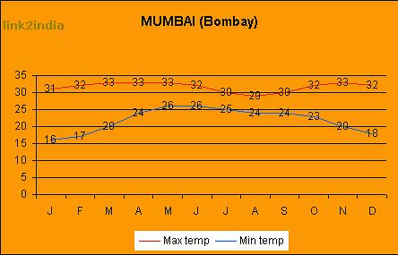
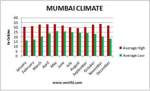
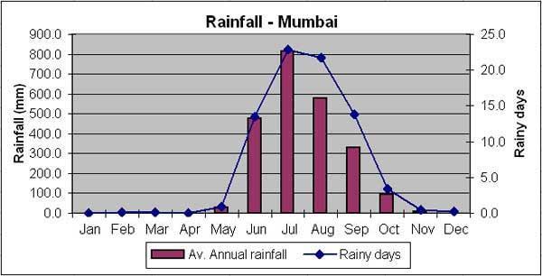
3 Country Profile India Location India is the largest peninsula in the world situated in Asia. As it is a peninsula it is surrounded by water on 3 sides and land on one side. Because of its size it is referred to as the Indian Sub-continent. The North of the country is bordered by Pakistan, China, Nepal, Bangladesh, Bhutan and Myanmar. The borders of the rest of the country are the Arabian Sea and the Indian Ocean. Physical geography Because of its size, the landscape of India is very varied. The Northern tips of India are mountainous and hilly being mainly the terrain of the Himalayas, although there are some lakes and forests too. Further south is the Indo- Gangetic plain, where three main rivers meet. This is a very fertile area. To the west of this region is the Thar Desert. Further south from here is the central region which is made up of mountains, known as Ghats, as well as forests, together known as the Deccan Plateau. The remainder of Southern India, bordered by water, is made up of rain forests, rivers and mixed vegetation. Climate Because of the size of the country, the climate is very different in different parts of India. The Northern areas within the Himalayas can get very cold and are ice bound in winter! The Indo-Gangetic plains experience very cold winters and very hot summers. Most of the central Deccan Plateau and Southern India has warm or hot weather throughout the year. A weather phenomenon that exists through a large part of India is the monsoon, which usually begins in June and can carry on till September. Mumbai is humid and hot through the year. Maximum temperatures can reach 35 C with lows of 18 C. During the monsoon months there is very heavy rainfall, which can be over 800mm in a month.
4 Human geography factfile Population: Land Size: Capital: Currency: 1,336,286,000 (second largest population in the world) 3,287,263 square kilometres (seventh largest country in the world) New Delhi Indian rupee Languages: Hindi is the main language but there are 22 official languages Main exports: Main food eaten: Life Expectancy: Crude oil, petroleum products, gold, gems and jewellery Rice, Rotis (wheat breads), Dal (lentils), vegetables 66.9 years for men and 69.9 years for women Religions: Hinduism and Islam are the two main religions. Christianity, Sikhism, Buddhism and Jainism are also followed.
5 History It has been shown that people lived in the area known as India more than 200,000 years ago. The Indus Valley Civilisation is one of the most ancient civilisations in the world and existed in and around the Indo-Gangetic Plain from around 3300BC. Various dynasties ruled India for many centuries and different cultures had their influence. The Persians, Greeks and Huns all inhabited India until about 6 th century AD. Often Northern and Southern India had different rulers, tribes and dynasties. Mughal Invasion The Turks and Afghans invaded India in the 10 th and 11 th centuries. They introduced Islam into the country and began what was to become the Moghul Dynasty in North India. Southern India was ruled by Hindu rulers and Empires. The country was therefore divided by rulers as well as religion. British Rule The East India Company came to India as a British trading company in early 1600s. Over the next 150 years they were involved in battles with French colonists and the Mughals and the British expanded their influence over the whole of India. In 1858 India became a part of the British Empire and was ruled by Britain until it gained independence in Modern India The Constitution of India came into effect on 26 January 1950 when India became a Republic. The constitution states that India is a sovereign, socialist, secular, democratic republic.

6 Map of British India Fig 1 : A map of British India 1. Why do you think British merchants wanted to work in India? 2. What can you discover about other countries which were part of the British Empire? 3. Find out which of the areas on this map are independent countries today? Which countries are these? 4. What was the difference between the areas of British Acquisition (in blue) and Dependent Indian States (in brown)?

7 Map of Modern India Look at the two maps. Fig 2 A map of Modern India 1. What differences can you see between the two maps of India? 2. How many states are there in India? 3. Can you describe the locations of the states of Kerala, Uttar Pradesh and Punjab?
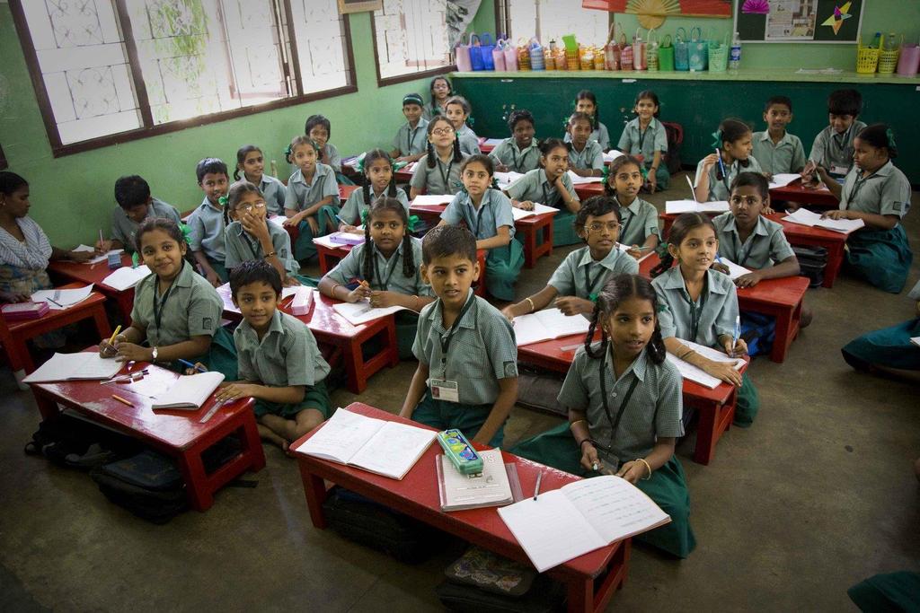
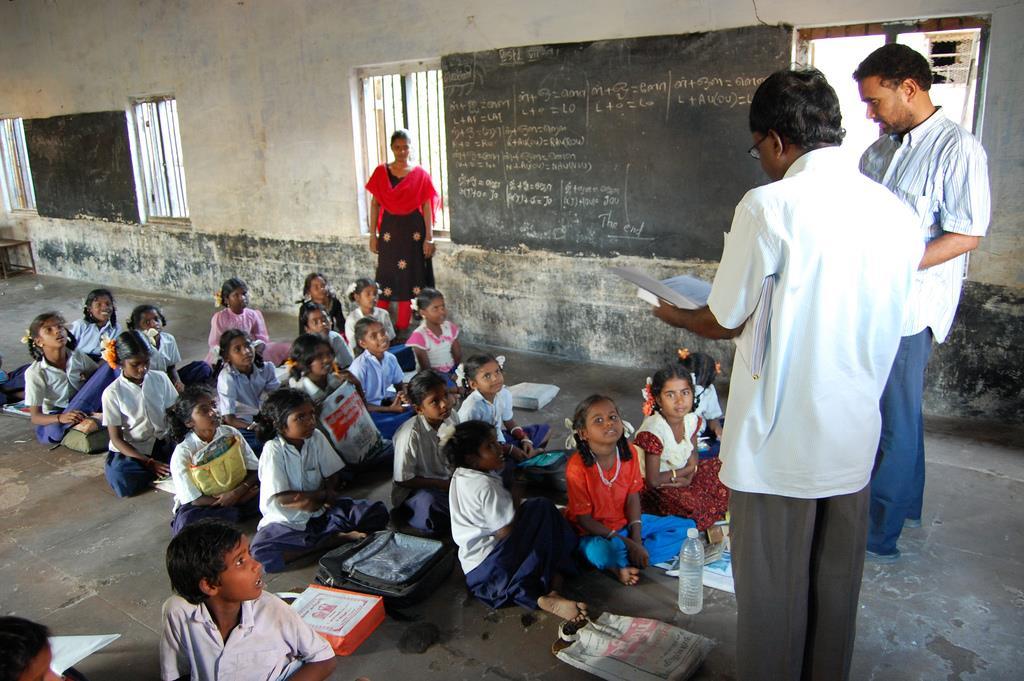
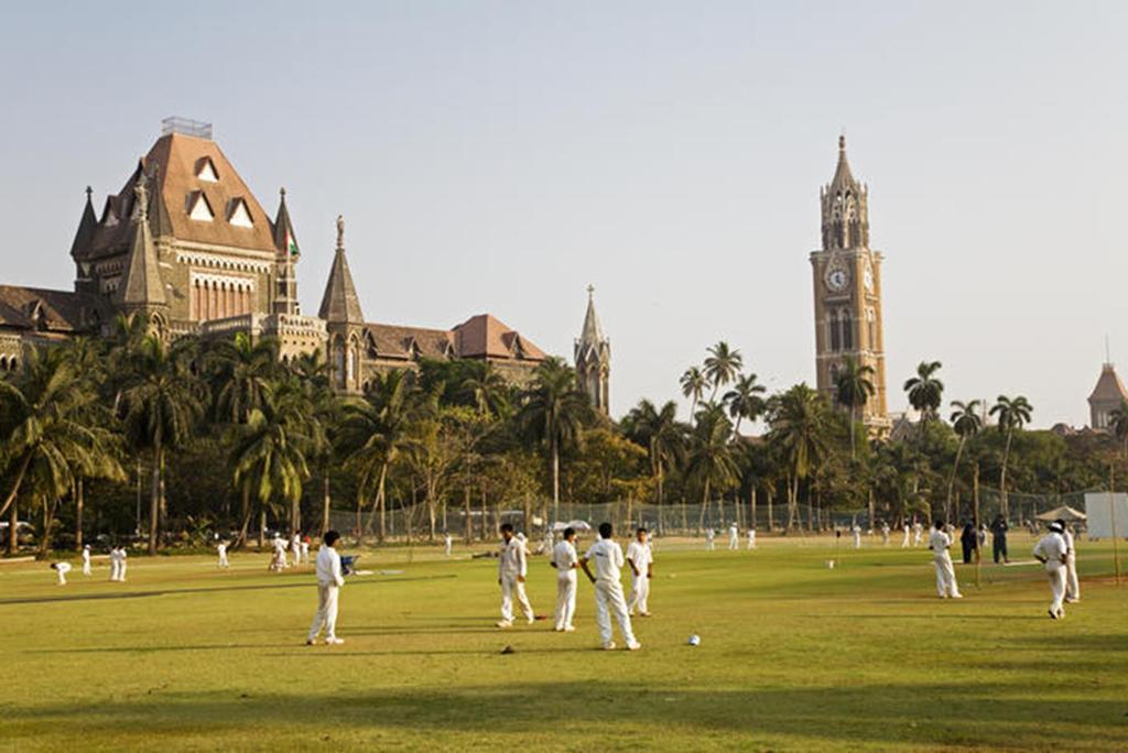
8 Key Stage 1 Geography Geographical skills and communication are developed throughout the activities. Locational knowledge 1. Pupils are given a series of clues from the Where in the world? pack and asked to investigate where in the world the country they are going to study is located. Pupils can use a world map to plot their ideas and then highlight the actual destination country. 2. Using a world map and atlas pupils are asked to describe where India is located, including the continent and surrounding countries. Encourage use of N/S/E/W Place knowledge/ Human and physical features 1. Pupils will begin the think about what makes a place unique by using their geographical skill of using photographs from the What can I find in a place? pack. Pupils are given a series of images and are asked to investigate what they can see. Begin with very general observations to build confidence. 2. Extend geographical understanding by asking pupils to label, apply labels or circle physical and human features. 3. Develop enquiry skills by asking pupils to pose geographical questions about some of the places in the photographs 4A-4H which show a series of human and physical images taken from India. For each image pupils have to think about what type of questions they might ask to find out more information. To support this activity further, teachers may want to provide additional information about each image which can be found in the teacher pack 4. My place/ your place what is the same? Comparing a small area of the UK and a small area of non-european country.
9 5. Begin as a whole class deciding what is important in a place places to play, transport, homes, schools and our environment. This could be a simple diagram. Then in small groups, pupils are given a series of images which depict life in Mumbai (Destination Mumbai pack). These are based around school, environment, transport and play. Teachers may want to focus on one category for comparison work. Pupils need to identify similarities/ differences between Mumbai and their own local area. Teachers might find it useful to provide some photographs of the local UK area for pupils to use. A basic comparison table is included at the back of these materials. 6. Using these images and any additional research pupils can produce an extended piece of writing appropriate to their year group e.g. a poster or a leaflet to illustrate how life in Mumbai is similar or different to life in their home area. Writing can be supported by completing a Venn diagram with key words and images.
10 Key Stage 2 Geography Geographical skills and communication are developed throughout the activities. Locational knowledge 1. Pupils will use a series of clues to work out hemisphere, continent, country, and city in the Where in the World? pack. An extension resource, Location Challenge, can be found at the end of this planning for use in consolidation of locational knowledge. 2. Pupils should then write an accurate geographical description of the locations of Mumbai and New Delhi. Teachers may wish to use the opportunity to revise the location of the home town of the pupils. There are many extensions possible here for example: calculation of distance, use of scale in an atlas and looking at time zones. In upper key stage two, pupils should be able to use lines of longitude and latitude to aid description. 3. The class could then go on to discuss what this location might mean for the physical geography of India. i.e. tropics, climate, vegetation, hazards. Pupils will need to research appropriate climate and vegetation maps to complete this task. 4. Pupils should use an up to date atlas to annotate a map of India to show the key human and physical landmarks. By Y6 this should include some topographical detail. Pupils should add a key, title and mark North, then discuss the scale of the maps used and produced.
11 Place knowledge/ Human and physical features Focus: comparing the physical and human geography of a region of the UK and a region of a non-european country. This stepped enquiry focuses on working like a geographer and using different pieces of information to investigate a region of India and compare it to the pupils home region. Awareness of new geographical terms and the comparison of similarity and difference are the main objectives. 1. Using the resources in the Destination Mumbai Pack, set the big picture by looking at the India fact file information. Set up a comparison challenge. What can the pupils find out about the UK to complete a big picture UK chart? Support this with atlas and guided internet searches. 2. A tale of two cities. What are the similarities between Newcastle upon Tyne (or your nearest city) and Mumbai? Discuss with pupils the questions they would need to ask to try and answer this question. Discuss the types of things they would need to know and how they might find out. Ensure coverage of physical and human geography. The areas of research might include weather, population, main jobs, life at school, and types of houses, places to play, transport, decision makers, foods, languages spoken, money used, vegetation, rivers, important buildings, a university, healthcare, and life expectancy. The photographs included in the pack can support many of these enquiries. Other sources should be used; some examples are in the Mumbai pack. A research table could be drawn up for pupils to use to record their initial findings. 3. Draw the enquiry together by comparing 3 aspects of life in Mumbai with 3 aspects of life in Newcastle. This can start as a Venn diagram and then be developed into a longer report style piece of writing or a news cast using the images from the pack and voiceovers written by the pupils. Emphasise the use of geographical terms. Pupils could include graphs or diagrams in their report.
12

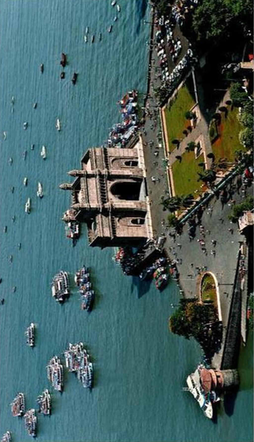
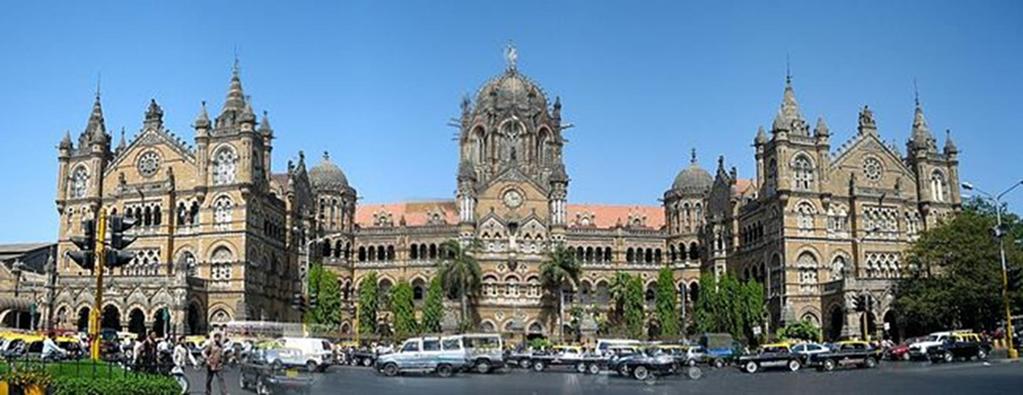
13 Aerial view KS1 Can you recognise this building? What is it called? Can you describe what you see? KS2 Why was this building built? What is its significance? Imagine that you are standing in front of this building. If you had to send a letter to a friend about it what would you write (location, purpose, history, climate, natural resources etc.)?

14 KS1 Label India. Label the Equator. Where is the UK? Using the words North, South, East and West, state where India is in comparison to UK. India is a hotter country than UK. Why do you think that might be the case? Some parts of India are colder than the UK. Why? Write the names of the oceans you can see. Which oceans are missing? Can you label them? KS2 In which hemisphere is India located? Find the latitude and longitude of India? Label the Equator, the Tropic of Cancer and the Tropic of Capricorn on your map? Name 3 other cities in different countries which fall within the same latitude as Mumbai. Is the climate the same in these cities? Explain your answers.


15 MAP 1 MAP 2 Map 1 shows the different localities which make up the city of Mumbai. Did you know that Mumbai is an island? KS1 What is an island? Using Map 2, name the bodies of water that make Mumbai an island. There are 3 lakes and 3 rivers within Map 2. Can you name them? Are there any lakes near to where we live?
16 KS2 What differences can you see between the two maps? How does having access to water benefit Mumbai? Gather information about the monsoons and complete the table Causes The monsoons Key facts Positive impact Negative impact

17 The Ganges KS1 The Ganges is the longest river in India. It flows through villages and towns. What do people use the river for? KS2 extension Where is the source of the Ganges and where is the river mouth? How long is the river? Does it have any tributaries? Name them. Investigate these important factors of the course of the river Ganges The Gangotri Glacier and waterfall The river basin The Ganges Delta Why is the Ganges so polluted?
18
19
20
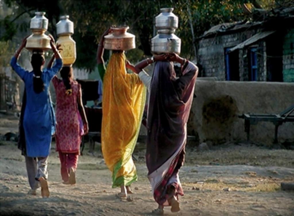
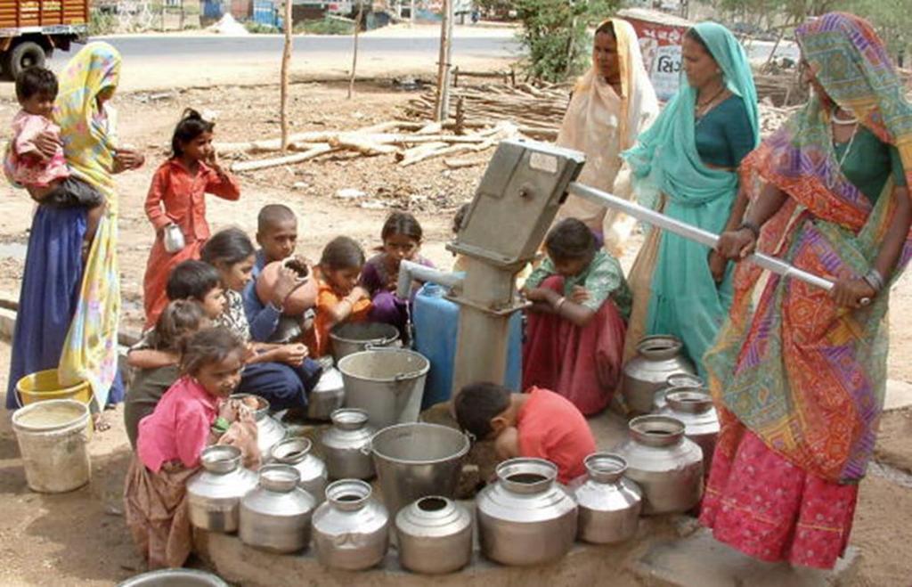
21 These images show women gathering and transporting water. KS1 The children can discuss why people need to do this. The water is being collected from a pump which could be a long distance from the village. How are they carrying the water? Why are mainly women doing this? Where are the men? What is the water used for? How often in a day will they need to do this? KS2 extension Extension work can be done on agriculture and irrigation in India. How are fields irrigated? What crops are grown? Looking at the pump in the photo, explain how it would work, where the water would come from, how deep will it need to be? Water from wells are still being collected and used in India. Why is this? Is it an effective and hygienic source of drinking water?
22
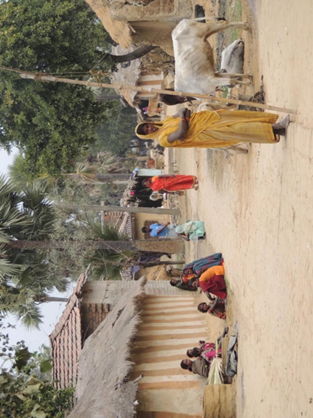
23 This is one village in India. KS1 It looks like a hot day and there are mainly women to be seen. What would the temperature be? Where are the men? If they are working, what would they be doing? Why are the women and children sitting outside? What are the cows for? What kind of houses can be seen? What are they made of? What is the same as our village and what is different? KS2 extension What is village life like in India? Do the children get an education? Do they also work? How does the community sustain itself? Describe what sort of crops are grown, what is manufactured and in what way are animals used?
24
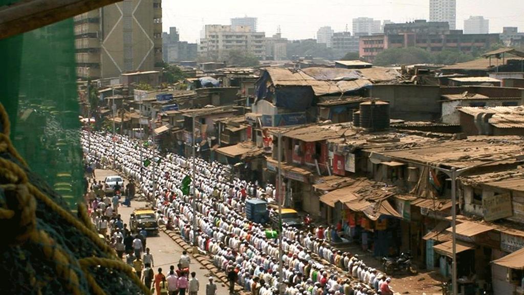
25 City of contrasts KS1 What can you see in this picture? What is in the background? What is in front? Why are so many people kneeling? Which words can you use to describe different parts of this photo? KS2 Look at the photo of Mumbai. Find and label ; Business or wealthy area Transport link Shanty housing Street lighting What can you work out from the photograph about life in Mumbai? Think about weather, housing, work, transport, religion, population.

26 KS1 This area of Mumbai is known as the Queen s Necklace. In what way is this picture different to the previous picture? Who do you think lives in this area? What happens here? KS2 extension What can you find out about this? Compare and contrast it with the earlier picture. Find out some more information about this area. Using the two images, explain in what ways Mumbai is a city of contrasts.
27 Destination Mumbai
28
29
30
31
32 Mumbai school fact file There is no compulsory schooling in India. There are different types of schools. There are free schools which are available to all children and can be run from a single room, often in the poorer areas. There are government school, some free and some fee paying. Then there are the private fee paying schools which provide education from nursery to school leaving. Classroom sizes are big, with up to 50 children in a class with one teacher. The day is long and children are given regular homework from an early age. Parents are responsible for ensuring that the homework is done. Lessons are taught in a number of languages; Marathi, Hindi or English. Children usually learn all three languages. The University of Mumbai was founded in It is based on the collegiate system where students enrol with a college but get their degree from the University. How many languages are spoken in the UK? Are there any similar universities in the UK?
33
34

35
36 KS1: My place your place Spotting differences and things that are similar Use the photographs to see what you can find Mumbai My home area Places to play Transport School Environment
St John s Catholic Primary School. Geography Policy. Mission Statement
 St John s Catholic Primary School Geography Policy Mission Statement We at St John s strive for excellence in education by providing a safe, secure and caring family environment where individuals are valued
The Impact of Geography in South and East Asia
 The Impact of Geography in South and East Asia Gobi desert, Mongolia Essential Question: How does the geography of SE Asia impact trade and the distribution of population throughout the region? (AKS #52a)
St. James C of E Primary School
 St. James C of E Primary School Geography Policy St. James C of E Primary School Geography Policy Written by: Lisa Harford Written: April 2016 Reviewed: April 2018 1. Introduction Geography is concerned
MEADOWS PRIMARY SCHOOL and NURSERY GEOGRAPHY POLICY
 MEADOWS PRIMARY SCHOOL and NURSERY GEOGRAPHY POLICY Purpose of study The teaching of Geography at Meadows is done by following the 2014 National Curriculum. The planning and teaching of the subject aims
The Impact of Geography in South and East Asia
 The Impact of Geography in South and East Asia Gobi desert, Mongolia Essential Question: How does the geography of SE Asia impact trade and the distribution of population throughout the region? (AKS #52a)
Our Lady Immaculate Catholic Primary School History and Geography Curriculum Map Would the Bog Baby survive in Liverpool?
 Year 1 and 2 - *Year 1 and 2 work on a two year cycle due to mixed classes Autumn 1 National Curriculum link: Human and physical geography - identify seasonal and daily weather patterns in the United Kingdom
Geography Policy 2014
 Geography Policy 2014 DEFINITION Geography education should inspire in pupils a curiosity and fascination about the world and its people that will remain with them for the rest of their lives. Teaching
GEOGRAPHY POLICY STATEMENT. The study of geography helps our pupils to make sense of the world around them.
 GEOGRAPHY POLICY STATEMENT We believe that the study of geography is concerned with people, place, space and the environment and explores the relationships between the earth and its peoples. The study
Subject Progression Map
 Subject Progression Map On website Subject Name: Geography Vision-Taken from the National Curriculum A high-quality geography education should inspire in pupils a curiosity and fascination about the world
ST AMBROSE CATHOLIC PRIMARY SCHOOL Geography Policy
 ST AMBROSE CATHOLIC PRIMARY SCHOOL Geography Policy 2017-2018 Our school policy is developed in accordance with the National Curriculum for Geography and Foundation Stage Curriculum for Understanding of
Year 3 Geography Expectations
 Year 3 Geography Expectations Year 3 Geography Knowledge, Skills and Understanding Geographical Enquiry Physical Geography Human Geography Geographical Knowledge Do they use correct geographical words
Geography. Programmes of study for Key Stages 1-3
 Geography Programmes of study for Key Stages 1-3 February 2013 Contents Purpose of study 3 Aims 3 Attainment targets 3 Subject content 4 Key Stage 1 4 Key Stage 2 5 Key Stage 3 6 2 Purpose of study A high-quality
Geography Route Planner
 Geography Route Planner Introduction to Route Planners Route Planners outline the Key Stages 1-3 curriculum to be taught within each campus of the Bury St Edmunds Trust. Each Route Planner has been designed
Range of Opportunities
 Geograhy Curriculum Cropwell Bishop Primary School Range of Opportunities Year 1 Year 2 Year 3 Year 4 Year 5 Year 6 All Key Stage 1 Key Stage 2 Investigate the countries and capitals of the United Kingdom.
Children needing support to achieve key skills. Children surpassing key skills. Geography Progression in Skills Key Stage One. Locational Knowledge
 Skills Locational Knowledge Geography Progression in Skills Key Stage One Children needing support to achieve key skills Children surpassing key skills To understand that the world extends outside their
name and locate the world s seven continents and five oceans
 Subject: Geography Activities National Curriculum Objectives One Progression of Skills Name the 7 continents and 5 oceans 3D Jigsaw task to locate continents and seas name and locate the world s seven
Nursery. Reception. Year 1
 Nursery Geography Overview Autumn Spring Summer Notices detailed features of objects in their environment. Comments and asks questions about aspects of their familiar world such as the place where they
Geography Long Term Plan 2018
 Geography Long Term Plan 2018 Geography Co-ordinator: Megan Frost A high-quality geography education should inspire in pupils a curiosity and fascination about the world and its people that will remain
KS1. Geography Progression of Knowledge, Understanding and Skills WIJPS
 Geography Progression of Knowledge, Understanding and Skills WIJPS Geography inspires pupils to delve deeper and with more curiosity and fascination into the world around them and its people. The knowledge
St Joseph s R.C. Primary School. Policy for Geography
 St Joseph s R.C. Primary School Policy for Geography 2016-2017 This policy is written with consideration to our school commitment to the Rights of the Child and our achievement of becoming a Rights Respecting
HOLY CROSS CATHOLIC PRIMARY SCHOOL
 HOLY CROSS CATHOLIC PRIMARY SCHOOL Geography Policy Date Implemented Jan 17 Review Date Jan 22 Mission Statement Holy Cross Primary School is a Catholic School. We seek to provide a broad, balanced Christian
Geography Policy. Introduction
 Geography Policy Introduction Geography at St. Aloysius Federation School teaches an understanding of places and environments and aims to inspire a curiosity and fascination about the world and its people.
Geography Policy. for Hertsmere Jewish Primary School
 Geography Policy for Hertsmere Jewish Primary School Reviewed by: L Rubin Reviewed on: September 2017 Date of Next Review: September 2018 Policy Review This policy will be reviewed in full by the Governing
Pikes Lane Primary School. Geography Statement of Practice
 Pikes Lane Primary School Geography Statement of Practice Subject Leader: Mrs Cawley Subject Link Governor: Mr Scholar & Mrs Azad Last Updated: September 2016 Review Date: September 2017 Aims and objectives
Tuition, Medical and Behaviour Support Service
 Tuition, Medical and Behaviour Support Service Curriculum Policy - Primary Geography Reviewed: October 2018 Next Review: October 2019 Responsibility: Andrea Snow AIMS AND PRINCIPLES The national curriculum
GEOGRAPHY POLICY. Date: March Signed: Review: March 2019
 GEOGRAPHY POLICY Date: March 2018 Signed: Review: March 2019 Aims At Hayton C of E Primary School we believe that Geography is an essential part of the curriculum and teachers ensure that the children
New National Curriculum Geography Skills Planning KS1
 New National Curriculum Geography Skills Planning KS1 Enquiry Question Objective-essential knowledge skills or understanding Locational Knowledge Standards /Success Criteria Lesson progression over half
The Impact of Geography in South and East Asia
 The Impact of Geography in South and East Asia Gobi desert, Mongolia Essential Question: How does geography impact the distribution of population throughout South and East Asia? I CAN Explain how geography
STAG LANE JUNIOR SCHOOL GEOGRAPHY POLICY
 Status-Recommended Prepared by: Megha Visavadia Date written January 2017 Shared with staff: Spring 2017 STAG LANE JUNIOR SCHOOL GEOGRAPHY POLICY Shared with governors: Spring 2018 Date for review: July
Year 34 B2 Geography - Continents and Oceans 2018 Key Skills to be covered: Taken from Level 3 Taken from Level 4
 Key Skills to be covered: Taken from Level 3 Taken from Level 4 Geographical Enquiry: I ask, Which PHYSICAL features does this place have? I ask, Which HUMAN features does this place have? I give reasons
Class 4J Spring Term Irian Jaya/Papua New Guinea Adapted from QCA Geography Unit 10 incorporating some elements of Unit 25
 Class 4J Spring Term 2003 Geography Irian Jaya/Papua New Guinea Geography Unit 10 incorporating some elements of Unit 25 ABOUT THE UNIT In this unit children develop ideas about a less economically developed
Complete Geography Overview: Year 1 to Year 6
 Option 1 Complete Geography Overview: Year 1 to Year 6 Autumn Term Spring Term Summer Term Year 1 Where do I live? Around the World The Four Seasons Year 2 At the Farm Let s go on Safari My World and Me
Class 4J Autumn Term St. Lucia Adapted from QCA Geography Unit 10 incorporating some elements of Unit 25
 Class 4J Autumn Term 2002 Geography St. Lucia Geography Unit 10 incorporating some elements of Unit 25 ABOUT THE UNIT In this unit children develop ideas about a less economically developed country. When
Display/Resources ideas:
 Year 3/4 Key Skills to be covered, taken from National Curriculum pitching at the correct year group and differentiation within plan for different groups Be specific in the key skills, and make them more
HAREWOOD JUNIOR SCHOOL KEY SKILLS
 HAREWOOD JUNIOR SCHOOL KEY SKILLS Geography Purpose of study A high-quality geography education should inspire in pupils a curiosity and fascination about the world and its people that will remain with
About places and/or important events Landmarks Maps How the land is, hills or flat or mountain range Connected to maps World Different countries
 What do you think you know about geography? About places and/or important events Landmarks Maps How the land is, hills or flat or mountain range Connected to maps World Different countries What do you
Geography Skills Progression. Eden Park Primary School Academy
 Geography Skills Progression Eden Park Primary School Academy In order to ensure broad and balanced coverage, we follow these principles: Within each phase, geography is a driver for at least 3 Learning
Geography Long Term Plan
 Geography Long Term Plan Year Group Children should be taught about: The topic this will be based on: Essential Learning Objectives: (Taken from Chris Quigley) Year 1 Name and locate the world s seven
Witchampton CofE First School Geography Curriculum Map
 2016-2017 Autumn People and : 30-50 Show interest in the lives of people who are familiar to them. Shows interest in different occupations. Remembers and talks significant events in their own experience.
Use maps, atlases, globes and computer mapping to locate countries and describe features studied
 Roseberry Primary School Curriculum planning Lead Question: What s so amazing about America? National Curriculum driver: Geography Rationale statement: In this study about the amazing Americas, children
BLACK PEAR TRUST SUBJECT PLAN - GEOGRAPHY
 Purpose of Study A high-quality geography education should inspire in pupils a curiosity and fascination about the world and its people that will remain with them for the rest of their lives. Teaching
Cranford Park CE Primary School. Subject Overview for Geography. Autumn 1 Autumn 2 Spring 1 Spring 2 Summer 1 Summer 2 Title of unit.
 Autumn 1 Autumn 2 Spring 1 Spring 2 Summer 1 Summer 2 Main Objectives /Skills Main Objectives /Skills Main Objectives /Skills Main Objectives /Skills Main Objectives /Skills Main Objectives /Skills Foundation
Walworth Primary School
 Walworth Primary School Date: April 2016 Revision Due: April 2017 Ref: L.Smith Geography Policy 1 Geography Policy Introduction A high quality geography education should inspire in pupils a curiosity and
Geography Progression
 Geography Progression This document aims to track expectations for History within George Grenville Academy. What the National Curriculum says: KS1: Locational Knowledge: Name and locate the world s 7 continents
Gedney Church End and Lutton St Nicholas Federated Primary Schools. Geography Policy
 Gedney Church End and Lutton St Nicholas Federated Primary Schools Geography Policy Contents: Introduction Expectations in Key Stage 1 Expectations in Key Stage 2 Aims Teaching and Learning Key Skills
The Geography Curriculum at Coston Primary
 The Geography Curriculum at Coston Primary Years Year 1 Year 2 Summer We are learning about where food is farmed and in The physical features of farms. The human features of farms. The characteristics
Geography Mile Post 1
 Mile Post 1 Use world maps, atlases and globes to identify the UK and its countries, as well as the countries, continents and oceans studied at this key stage Key Skills IPC learning Goals 1.11 Be able
Building the next generation of global citizens! Curriculum. International Sports Exchange
 Building the next generation of global citizens! Curriculum International Sports Exchange CURRICULUM Unit TItle: SOUTHERN AFRICA Unit Length: Weeks Guiding Questions: Can students locate the region of
Chapter 21 Southwest Asia: Harsh & Arid Lands
 Name Hour Chapter 21 Southwest Asia: Harsh & Arid Lands Essential Question: How has the physical geography of Asia influenced the development of these regions (i.e. history, population distribution, &
Sec$on 1: Geography and Early China. How does China s geography affect the culture?
 Sec$on 1: Geography and Early China How does China s geography affect the culture? Con$nents of the World Label the continents. Where is China located? Where is China located? In your groups, begin filling
Year 3 The Ancient Egyptians
 Year 3 The Ancient Egyptians Spring Term Art Design and Technology Geography History Science National Curriculum Pupils should be taught: to create sketch books to record their observations and use them
Geography Long Term Plan. Autumn Spring Summer
 Geography Long Term Plan Autumn Spring Summer Year 1 Working Scientifically covered throughout the year Location Geography of UK Name, locate and identify characteristics of the four countries and capital
Chapter 2 - Lessons 1 & 2 Studying Geography, Economics
 Chapter 2 - Lessons 1 & 2 Studying Geography, Economics How does geography influence the way people live? Why do people trade? Why do people form governments? Lesson 1 - How Does Geography Influence the
Iceland. 1. Warm up. A. Talk about the picture and read the essay. B. Discuss the questions about the essay.
 1. Warm up A. Talk about the picture and read the essay. Iceland My country, Iceland, is one of the most beautiful countries on Earth. It is an island country. It is located in Europe, in the North Atlantic
Ancient China. Teachers Curriculum Institute Geography and the Early Settlement of China 1. AW_ISN_U04_01 Ancient China Second Proof TCI18 108
 G e o g r a p h y C h a l l e n g e Ancient China N W E S 0 250 500 miles 0 250 500 kilometers Albers Conic Equal-Area Projection AW_ISN_U04_01 Ancient China Second Proof TCI18 108 Teachers Curriculum
Name three countries in Europe.
 Name three countries in Europe. I will be able to identify the 5 themes of geography for Europe and locate the countries and capitals of Europe and the major physical features. People: Past: Through the
Dr. M.K.K. Arya Model School Class-V, Social Science Assignment Ch-1, Globe The Model of the Earth Answer the following:- Q.1.
 Class-V, Social Science Assignment Ch-1, Globe The Model of the Earth - Q.1. What are the disadvantages/demerits of a globe? Ans. Some disadvantages of globe are: a) It is difficult to carry. b) It cannot
GEOGRAPHY CURRICULUM OVERVIEW
 GEOGRAPHY CURRICULUM OVERVIEW Geographical knowledge Progression Statement Autumn Spring Summer Year 1 UK and Local Area: Physical Themes: Name, locate and identify characteristics of the 4 countries and
Year 1 name and locate the four countries and capital cities of the United Kingdom and its surrounding seas
 Long Term Objective Organisation for Geography Please note that only statutory requirements should be included in this document; any supplementary guidance and information should be retained by Subject
Chapter 27. Bhutan, Maldives, Nepal, & Sri Lanka
 Chapter 27 Bhutan, Maldives, Nepal, & Sri Lanka Physical Geography of Bhutan, Maldives, Nepal & Sri Lanka Landforms Their locations on the fringe of South Asia means their physical and human geography
Barlows Primary School Geography Curriculum Content Key Stage 1 and
 Geography Curriculum Content Key Stage 1 and 2 2017-2018 Curriculum Content Year 1 The content for Year 1 is detailed below: WHAT ARE SEASONS? WHAT SIT LIKE WHERE WE LIVE? WHERE DO DIFFERENT ANIMALS LIVE?
locate the world s countries, using maps to focus on Europe (including the location of
 Year 3 and 4 Geography study- Autumn 2 2017 National curriculum: Locational knowledge locate the world s countries, using maps to focus on Europe (including the location of Russia) and North and South
NEWHAM BRIDGE PRIMARY SCHOOL FOUNDATION SUBJECTS CURRICULUM AND ASSESSMENT DOCUMENT GEOGRAPHY
 NEWHAM BRIDGE PRIMARY SCHOOL FOUNDATION SUBJECTS CURRICULUM AND ASSESSMENT DOCUMENT GEOGRAPHY Y1 Geography Curriculum Y1 Geography A.R.E Locational language: hills, beach, forest, town, country, address,
What on Earth is Geography? Using the Five Themes of Geography to Study the Continent of Asia.
 What on Earth is Geography? Using the Five Themes of Geography to Study the Continent of Asia. Name Date Essential questions: 1. How can we study the geography of our Earth? a. What are the five themes
Abbotswood Junior School National Curriculum 2014
 Geography Purpose A high-quality geography education should inspire in pupils a curiosity and fascination about the world and its people that will remain with them for the rest of their lives. Teaching
Introduction to India. George Kuhter South Tama County Middle School, Toledo, IA
 Instructional Sequence/Procedure (Req.): 1. India: An Introduction Have students read India: An Introduction. After reading this, you may need to discuss some of the information presented in the reading
GRADE 6 GEOGRAPHY TERM 1 LATITUDE AND LONGITUDE (degrees)
") 1 GRADE 6 GEOGRAPHY TERM 1 LATITUDE AND LONGITUDE (degrees) Contents Lines of Latitude... 2 Lines of Longitude... 3 The hemispheres of The Earth... 4 Finding countries and cities on a map using latitude
1 GRADE 6 GEOGRAPHY TERM 1 LATITUDE AND LONGITUDE (degrees) Contents Lines of Latitude... 2 Lines of Longitude... 3 The hemispheres of The Earth... 4 Finding countries and cities on a map using latitude
Landmarks Paula Owens 5 7 years
 Landmarks Paula Owens Geography teaching resource 5 7 years This is one of a series of teaching resources for use with Digimap for Schools. For more details about this service, visit http://digimapforschools.edina.ac.uk
Ancient China UNIT 4 GEOGRAPHY CHALLENGE. 1 Unit 4 Geography Challenge. Teachers Curriculum Institute
 UNIT 4 GEOGRAPHY CHALLENGE Ancient China N W E S 0 250 500 miles 0 250 500 kilometers Albers Conic Equal-Area Projection AW_ISN_U04_01 Ancient China Second Proof TCI18 108 1 Unit 4 Geography Challenge
NATIONAL CURRICULUM GEOGRAPHY PLANNING OVERVIEW
 GEOGRAPHY AUTUMN TERM SPRING TERM SUMMER TERM Year 1 Hunting and Hiding Me and My Wonderful World Beside The Sea identify seasonal and daily weather patterns in the United Kingdom and the location of hot
South, Southeast, and East Asia. Physical Geography
 South, Southeast, and East Asia Physical Geography Mountains v Mountains are important in Asia because they influence: A. Population patterns B. Movement of people and goods C. Climate Mountains v The
Roman Road Primary School. Policy for Geography
 Roman Road Primary School Policy for Geography Reviewed May 2017 Next Review May 2018 POLICY FOR GEOGRAPHY Document Purpose This policy reflects the values, ethos and philosophy of Roman Road Primary School
5. What is latitude and longitude? 6. What do we mean by the UK? 2 B: Africa 1. To identify the physical features of Africa
 Geography Year 7 Year 7 Coordinator Mr.LLoyd Topics of Study This Year: Students study a broad range of introductory units that cover key skills and themes that will be developed throughout KS3. Students
Ancient India UNIT 3 GEOGRAPHY CHALLENGE A L A. 1 Unit 3 Geography Challenge. Teachers Curriculum Institute miles
 UNIT 3 GEOGRPHY CHLLENGE ncient India HINDU KUSH HINDU KUSH H I M Desert Thar L Y N W E S 0 250 500 miles 0 250 500 kilometers Lambert zimuthal Equal-rea Projection 1 Unit 3 Geography Challenge UNIT 3
Holy Trinity 3-16 School. Geography Overview (Primary)
") Holy Trinity 3-16 School Key Stage 1 Geography Overview (Primary) Year Autumn 1 Autumn 2 Spring1 Spring 2 Summer 1 Summer 2 Y1 Dear Zoo Castles Gadgets and Gizmos (UK) Name, locate and identify characteristics
Holy Trinity 3-16 School Key Stage 1 Geography Overview (Primary) Year Autumn 1 Autumn 2 Spring1 Spring 2 Summer 1 Summer 2 Y1 Dear Zoo Castles Gadgets and Gizmos (UK) Name, locate and identify characteristics
Essential Questions What are the major physical components of the world, and how are they represented on a map? 3.4
 Third Grade Social Studies Unit One Six Weeks GEOGRAPHY Originally compiled by Russellville In order for students to understand that geography influences the development of a region as well as the interactions
Facts about Japan. The location of Japan
 Facts about Japan Form of Government: Constitutional monarchy with parliamentary government Capital: Tokyo Population: 126, 048, 450 Official Language: Japanese Money: Japanese yen Area: 377,835 square
Subject: Geography Scheme of Work: B1 to B6 Mastery tiles. Term: Autumn/Spring/Summer
 Subject: Geography Scheme of Work: B1 to B6 Mastery tiles Term: Autumn/Spring/Summer Topic / Unit(s) Overview / Context Introduction to geography. An introduction to geography including basic map skills
Unit 1: Basics of Geography Test Review
 Name Date Period Unit 1: Basics of Geography Test Review Directions: Reading the following sections and complete the questions, charts, and diagrams. Types of Maps Maps that have a particular theme are
Geography and the Early Settlement of China
 Geography and the Early Settlement of I N T E R A C T I V E S T U D E N T N O T E B O O K How did geography affect life in ancient? P R E V I E W Physical Features 1. Circle the physical features that
Exploring the Geography of West Asia
 Unit 3 - Lesson 1 Content Expectations 7 G1.1.1: Explain and use a variety of maps, globes, and web based geography technology to study the world, including global, interregional, regional, and local scales.
CHAPTER 1: EXPLORING GEOGRAPHY
 CHAPTER 1: EXPLORING GEOGRAPHY Please Do Now: In your PDN section of your binder answer the following with one or two sentences: What is Geography? What is Geography? The study of where people, places,
Geography Curriculum Policy
 Geography Curriculum Policy Subject Leader: Jo Hamill From: September 2016 The Purpose of the Policy At Winlaton West Lane Primary, we aim to deliver a high-quality Geography education should inspire in
Chapter 27. Bhutan, Maldives, Nepal, & Sri Lanka
 Chapter 27 Bhutan, Maldives, Nepal, & Sri Lanka Physical Geography of Bhutan, Maldives, Nepal & Sri Lanka Landforms Their locations on the fringe of South Asia means their physical and human geography
Rebecca Nayler Medium term planning. Curriculum area GEOGRAPHY - AUTUMN 2016
 Medium term planning Curriculum area GEOGRAPHY - AUTUMN 2016 As geographers we are getting better at: LO s EYFS Early Learning Goal Children know about similarities and differences in relation to places,
Northwestern Consolidated Schools of Shelby County. Curriculum. World Studies (Eastern Hemisphere) Prepared by. Rich Ballard
 Prepared by. Rich Ballard") Northwestern Consolidated Schools of Shelby County Curriculum World Studies (Eastern Hemisphere) 7th Grade Prepared by Rich Ballard 2012-2013 1 Triton Central Middle School Vision Statement We are committed
Northwestern Consolidated Schools of Shelby County Curriculum World Studies (Eastern Hemisphere) 7th Grade Prepared by Rich Ballard 2012-2013 1 Triton Central Middle School Vision Statement We are committed
Geography Curriculum. Key Stage 1
 Geography Curriculum Key Stage 1 Year 1 In the first term, students explore a variety of maps of the local environment, including the Academy grounds. They use a paper location to plan a route. They also
September 14, 2013 Objective: How does geography impact history? What important features exist that have shaped societies?
 Lowenhaupt 1 September 14, 2013 Objective: How does geography impact history? What important features exist that have shaped societies? Warm-Up: In your binder, answer the following question: Imagine you
Sample. Contents SECTION 1: PLACE NAMES 6 SECTION 2: CONNECTING TO PLACES 21 SECTION 3: SPACES: NEAR AND FAR 53
 Contents Teachers' Notes 4 National Curriculum Links 5 SECTION 1: PLACE NAMES 6 Teachers' Notes 7-8 Activities Names Of Places 9 Place Names Are Important 1 10 Place Names Are Important 2 11 The Meanings
LET S GO ON A ROAD TRIP
 Partner School News June 2016 In this issue: Education Children Around the World www.opportunityeducation.org Road Trip Start Writing Right Now Teaching Tip of the Month Focus on Schools LET S GO ON A
HOMEWORK CURRICULUM Geography
 HOMEWORK CURRICULUM Geography 2013-2014 Year 7 Term 1 Weather and Climate (will run 2-3 weeks into term 2) Make a mini weather station. Record the weather daily for 3 weeks Write a report on what the data
Sherwood Primary School POLICY FOR GEOGRAPHY
 Sherwood Primary School POLICY FOR GEOGRAPHY JUNE 2015 POLICY FOR GEOGRAPHY Purpose of study A high-quality geography education should inspire in pupils a curiosity and fascination about the world and
SOCIAL STUDIES GRADE 6. I Can Checklist REGIONS AND PEOPLE OF THE EASTERN HEMISPHERE. Office of Teaching and Learning Curriculum Division
 SOCIAL STUDIES REGIONS AND PEOPLE OF THE EASTERN HEMISPHERE GRADE 6 I Can Checklist 2018-2019 Aligned with Ohio s Learning Standards for Social Studies Office of Teaching and Learning Curriculum Division
UNIT4. Ancient China. Geography and the Early Settlement of China. Three Chinese Philosophies The First Emperor of China
 UNIT4 Ancient China Lesson 19 Lesson 20 Lesson 21 Lesson 22 Lesson 23 Lesson 24 Geography and the Early Settlement of China The Shang Dynasty Three Chinese Philosophies The First Emperor of China The Han
The Five Themes of Geography
 The Five Themes of Geography The Five Themes of Geography Main Idea: Geographers use the Five Themes of Geography to help them study the Earth. The Five Themes of Geography Geography and You: Suppose a
Grade Level, Course Third Grade Social Studies PLSD Balanced Assessment Practices. Type* DOK
 Unit Guides Assessment Items Indic ator s Concept Standard Curricular Indicator DOK Type* SR CR PB Assessment Questions # DOK Level 1E 1M 1H 2E 2M 2H 3E 3M 3H Civics Students will develop and apply the
Geography Skills Progression Key Stage 2
 Year 3 Year 4 Year 5 Year 6 Expectations at end of key stage Location knowledge the countries of Europe? countries in Europe, environmental regions? countries in Europe, key physical and human characteristics?
Welcome Survey getting to know you Collect & log Supplies received Classroom Rules Curriculum overview. 1 : Aug 810. (3 days) 2nd: Aug (5 days)
 2nd: Aug (5 days)") 1st Quarter (41Days) st 1 : Aug 810 (3 days) 2nd: Aug 13-17 Reporting Categories (TEKS SEs) Skill Create and write a postcard about your favorite community activity Review 2nd Grade Vocabulary Chapter
1st Quarter (41Days) st 1 : Aug 810 (3 days) 2nd: Aug 13-17 Reporting Categories (TEKS SEs) Skill Create and write a postcard about your favorite community activity Review 2nd Grade Vocabulary Chapter
Progression of skills in Geography
 New Curriculum Holy Trinity CE Primary Academy 2013-14 Subject: Geography Skills: Progression of skills in Geography Geographical enquiry Teacher led enquiries, to ask and respond to simple closed questions.
TRIBUNE MODEL SCHOOL Syllabus for Session Subject: Social Science CLASS IV
 TRIBUNE MODEL SCHOOL Syllabus for Session 2017-18 Subject: Social Science CLASS IV Text Books 1. Candid New Trends in Social Science 4 2. Candid New Trends in Social Science (Worksheets) 4 Term I (Chapters