Travel to School: Social and Spatial Inequalities in Local Housing and Education Markets
|
|
|
- Domenic Merritt
- 5 years ago
- Views:
Transcription
1 Travel to School: Social and Spatial Inequalities in Local Housing and Education Markets Dr Sue Easton Department of Town & Regional Planning University of Sheffield
2 Travel to School Policy Contexts/ Debates
3 Interplay of Housing & Education Markets Local authority run community schools still geographically tied to local neighbourhoods through catchment areas where distance is the tie-breaker if over-subscribed (Allen, 2007; Allen et al., 2013; Andersson et al., 2012; Burgess et al., 2011; Harris et al., 2007; Sheffield City Council, 2013; Taylor, 2009) >>> Parents with resources attempt to access the best schools by moving into desirable catchment areas of the most popular schools. This has led to an increase in price of housing in such areas (Black, 1999; Cheshire and Sheppard, 2004; Fingleton, 2006; Gibbons and Machin, 2003; Leech and Campos, 2001).
4 School Performance Affects House Prices Leech and Campos (2001) estimated the average additional increase in price for living in the catchment area for a good secondary school in Coventry in July 2000 to be between 10,000 and 20,000 (16-20%). Thus local school performance is linked to processes of spatial and social polarisation by feeding into residential sorting mechanisms. Low income families - cannot choose to go private ; - may not have the option to move house; - may be excluded from some areas through pricing; - may not have the resources to support travel to school
5 Primary School Performance Statistics PRIMARY Key Stage 2 Mean for all Difference from School Name Engl & Maths England Mean Abbey Lane Primary Acres Hill Com Angram Bnk Primary Anns Grove Primary Arbourthorne Com Athelstan Primary Ballifield Primary Bankwood Primary Beck Primary School Birley Primary Sch Birley Spa Primary Bradfield Dungworth

6 House Price ( ) and Primary School Performance (2012) in Sheffield Key to symbols: KS2 English & Maths High 5,000,000 Low 21,350
7 Changes to Education Policy 1980 Education Act & 1988 Education Reform Act enshrined parental choice and encouraged schools to opt out of Local Authority control Some parents have more choice than others Some schools with city-wide catchment areas (faith, single sex schools, academies). However, use of selection criteria enables opted out schools to cream-skim through selection by ability and to exclude certain types of pupil e.g. by behaviour (Allen, 2007; West et al., 2004).
8 Social & Spatial Inequity Over-subscription and selection criteria mean that nearby schools may not be accessible to local children. Constraints to obtaining a place at the best state schools have increased significantly for children from lower socioeconomic status (SES) backgrounds (Burgess and Briggs, 2006); (Hamnett and Butler, 2011). >>> De facto school catchment areas increasingly socially and spatially polarised (Harris and Johnston, 2008). Burgess et al. (2011) estimated that lowest SES quintile children in metropolitan areas were effectively excluded from over 70% of schools within 3km of their home.
9 School Choice & Excess Commuting Over half of all pupils now engage in excess commuting (travel further than their nearest school) (Allen, 2007; Ferrari and Green, 2013) Estimated to be 60% longer commute than nearest school in (Allen, 2007). Ferrari & Green (forthcoming) have estimated the daily excess commute to be 87,400 km for secondary pupils and 55,000 km for primary equating to approx. 1,500 tons of CO2 per year. Significant implications in terms of sustainability, carbon emissions and traffic congestion/flow for the future.
10 Costs and Policy Conflict High level of dependency on motorised transport linked to rising prices of fossil fuels. Increased cost to the public purse through local authorities subsidising bus passes for children who travel over 3 miles etc. Also issues of public health concern re active commuting, childhood obesity and building healthy exercise habits for life (Griffiths et al., 2013). Furthermore as the number of opted out schools increases (e.g. parent-run Free schools ), local authorities have less and less control to plan and manage despite rising demand for primary school places.
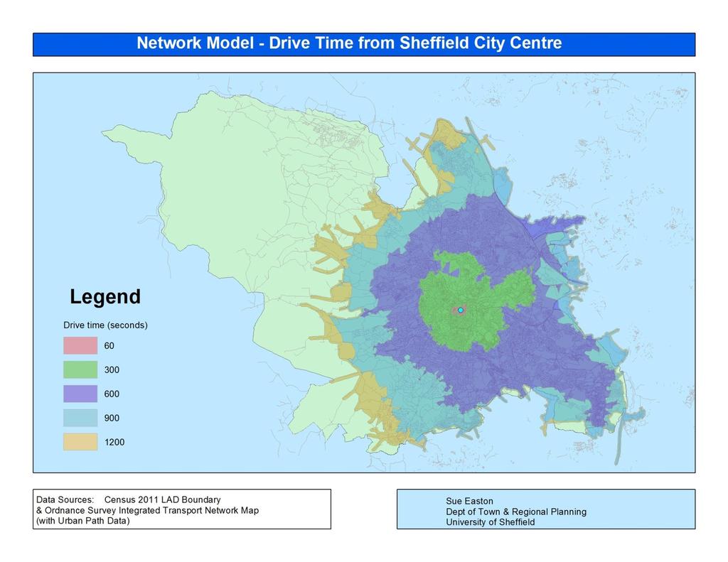
11 Our Research on Travel-to-School Examining Pupil, School & Neighbourhood characteristics within the same multilevel model. Mapping de facto and de jure catchment areas for Sheffield schools for different socioeconomic groups. Mapping the real educational choices available to families living in different neighbourhoods of the city - Barriers include: distance and travel time, access to transport e.g. bus routes, walkability and cyclability of the area (urban form measures).

12 Mapping with GIS Routes to Faith Schools
13
This is a repository copy of Travel to school and housing markets: a case study of Sheffield, England.
 This is a repository copy of Travel to school and housing markets: a case study of Sheffield, England. White Rose Research Online URL for this paper: http://eprints.whiterose.ac.uk/97538/ Version: Accepted
Victorian Liveability Indicator Program: Definition, Measurement and Application
 Victorian Liveability Indicator Program: Definition, Measurement and Application Dr Hannah Badland Senior Research Fellow Place, Health, and Liveability Program Melbourne School of Population and Global
Impact of Metropolitan-level Built Environment on Travel Behavior
 Impact of Metropolitan-level Built Environment on Travel Behavior Arefeh Nasri 1 and Lei Zhang 2,* 1. Graduate Research Assistant; 2. Assistant Professor (*Corresponding Author) Department of Civil and
Council Workshop on Neighbourhoods Thursday, October 4 th, :00 to 4:00 p.m. Burlington Performing Arts Centre
 Council Workshop on Neighbourhoods Thursday, October 4 th, 2012 1:00 to 4:00 p.m. Burlington Performing Arts Centre Agenda Introductions Warm-Up Exercise Presentation Exercise Neighbourhood Planning Break
Links between socio-economic and ethnic segregation at different spatial scales: a comparison between The Netherlands and Belgium
 Links between socio-economic and ethnic segregation at different spatial scales: a comparison between The Netherlands and Belgium Bart Sleutjes₁ & Rafael Costa₂ ₁ Netherlands Interdisciplinary Demographic
Urban Form and Travel Behavior:
 Urban Form and Travel Behavior: Experience from a Nordic Context! Presentation at the World Symposium on Transport and Land Use Research (WSTLUR), July 28, 2011 in Whistler, Canada! Petter Næss! Professor
Spatial index of educational opportunities: Rio de Janeiro and Belo Horizonte
 Available online at www.sciencedirect.com Procedia Social and Behavioral Sciences 21 (2011) 287 293 International Conference: Spatial Thinking and Geographic Information Sciences 2011 Spatial index of
TUESDAYS AT APA PLANNING AND HEALTH. SAGAR SHAH, PhD AMERICAN PLANNING ASSOCIATION SEPTEMBER 2017 DISCUSSING THE ROLE OF FACTORS INFLUENCING HEALTH
 SAGAR SHAH, PhD sshah@planning.org AMERICAN PLANNING ASSOCIATION SEPTEMBER 2017 TUESDAYS AT APA PLANNING AND HEALTH DISCUSSING THE ROLE OF FACTORS INFLUENCING HEALTH Outline of the Presentation PLANNING
BROOKINGS May
 Appendix 1. Technical Methodology This study combines detailed data on transit systems, demographics, and employment to determine the accessibility of jobs via transit within and across the country s 100
Developing Built Environment Indicators for Urban Oregon. Dan Rubado, MPH EPHT Epidemiologist Oregon Public Health Division
 Developing Built Environment Indicators for Urban Oregon Dan Rubado, MPH EPHT Epidemiologist Oregon Public Health Division What is the built environment? The built environment encompasses spaces and places
RURAL SETTLEMENT PATTERNS AND ACCESS TO DEVELOPMENT LAND: DEVELOPING THE EVIDENCE BASE
 School of Planning, Architecture and Civil Engineering RURAL SETTLEMENT PATTERNS AND ACCESS TO DEVELOPMENT LAND: DEVELOPING THE EVIDENCE BASE Prepared for Friends of the Earth Northern Ireland 18 th April
Energy Use in Homes 2004
 Energy Use in Homes 2004 A series of reports on domestic energy use in England Space and Water Heating Energy Use in Homes 2004 A series of reports on domestic energy use in England This is one of a series
A TRANSIT ACCESS ANALYSIS OF TANF RECIPIENTS IN THE CITY OF PORTLAND, OREGON
 A TRANSIT ACCESS ANALYSIS OF TANF RECIPIENTS IN THE CITY OF PORTLAND, OREGON By Thomas W. Sanchez Center for Urban Studies Portland State University ABSTRACT Little evidence exists regarding the relationship
Transportation and Social Equity as a Way to Alleviate Poverty
 Transportation and Social Equity as a Way to Alleviate Poverty The Case of Low-Income Neighborhoods in Savannah, GA Vishanya F. Forbes1, Dr. Deden Rukmana2 What is Social Equity? It s a term that implies
Frequently Asked Questions
 What is the Regional Transit Engagement Series? As one of the fastest growing regions in the country, there is recognition that long-term transit planning efforts should be accelerated if we are to remain
Integrating GIS into Food Access Analysis
 GIS Day at Kansas University Integrating GIS into Food Access Analysis Daoqin Tong School of Geography and Development Outline Introduction Research questions Method Results Discussion Introduction Food
Does primary school siting influence pupil s trip lengths in Flanders?
 Does primary school siting influence pupil s trip lengths in Flanders? Extended abstract submitted to the 2013 BIVEC Transport Research Day, May 30th and 31st, 2013, Luxembourg Kobe Boussauw*, ** Georges
Medical GIS: New Uses of Mapping Technology in Public Health. Peter Hayward, PhD Department of Geography SUNY College at Oneonta
 Medical GIS: New Uses of Mapping Technology in Public Health Peter Hayward, PhD Department of Geography SUNY College at Oneonta Invited research seminar presentation at Bassett Healthcare. Cooperstown,
GIS Analysis of Crenshaw/LAX Line
 PDD 631 Geographic Information Systems for Public Policy, Planning & Development GIS Analysis of Crenshaw/LAX Line Biying Zhao 6679361256 Professor Barry Waite and Bonnie Shrewsbury May 12 th, 2015 Introduction
Typical information required from the data collection can be grouped into four categories, enumerated as below.
 Chapter 6 Data Collection 6.1 Overview The four-stage modeling, an important tool for forecasting future demand and performance of a transportation system, was developed for evaluating large-scale infrastructure
Economic and Social Urban Indicators: A Spatial Decision Support System for Chicago Area Transportation Planning
 Economic and Social Urban Indicators: A Spatial Decision Support System for Chicago Area Transportation Planning Piyushimita Thakuriah (Vonu), P.S. Sriraj, Paul Metaxatos, Inshu Minocha & Tanushri Swarup
Shall we Dense?: Policy Potentials. Summary. Simon McPherson Director SJB Urban Australia au
 Shall we dense? Shall we Dense?: Policy Potentials Simon McPherson Director SJB Urban Australia smcpherson@sjb.com. au Adam Haddow Director SJB Architects Australia ahaddow@sjb.com.au Summary This paper
Sustainable Suburbs: Restructuring Suburban Development
 Sustainable Suburbs: Restructuring Suburban Development Stephen B. Friedman, AICP, CRE ULI Forum, October 8, 2009 The Vocabulary of Growth CAVE NIMBY BANANA NOTE NOPE NIMEY Triple Bottom Line Profitability
Engagement on Strategies to Overcome Inequality
 Engagement on Strategies to Overcome Inequality Civil Society Engagement with Poverty Julian Sendin 1-2 June 2017 Kievits Kroon Country Estate, Pretoria, South Africa 1. Ndifuna Ukwazi Ndifuna Ukwazi is
submission to plan melbourne
 submission to plan melbourne prepared by hansen partnership pty ltd december 2013 submission to plan melbourne hansen partnership pty ltd contents 1 introduction... 2 2 key issues facing melbourne...
Application of GIS in urban planning. Iran Experiences of land use planning and air pollution
 Application of GIS in urban planning Iran Experiences of land use planning and air pollution Index Introducing the case study Geographical characteristics Demographical characteristics Urban Development
The paper is based on commuting flows between rural and urban areas. Why is this of
 Commuting 1 The paper is based on commuting flows between rural and urban areas. Why is this of interest? Academically, extent of spread of urban agglomeration economies, also the nature of rural-urban
Dr.Sinisa Vukicevic Dr. Robert Summers
 Dr.Sinisa Vukicevic Dr. Robert Summers "Planning" means the scientific, aesthetic, and orderly disposition of land, resources, facilities and services with a view to securing the physical, economic and
Energy Use in Homes 2007
 Energy Use in Homes 2007 A series of reports on domestic energy use in England Space and Water Heating Energy Use in Homes 2007 A series of reports on domestic energy use in England This is one of a series
What s wrong with sprawl? The urgent need for cost benefit analyses of modern urban growth patterns. Jacy Gaige
 What s wrong with sprawl? The urgent need for cost benefit analyses of modern urban growth patterns. Jacy Gaige Urban Econ 245 Professor Charles Becker Literature Review 1 Urban is hip. Bikes, messenger
Energy Use in Homes. A series of reports on domestic energy use in England. Energy Efficiency
 Energy Use in Homes A series of reports on domestic energy use in England Energy Efficiency Energy Use in Homes A series of reports on domestic energy use in England This is one of a series of three reports
Mapping vulnerability to fuel price increases in England
 Institute for Transport Studies FACULTY OF ENVIRONMENT Mapping vulnerability to fuel price increases in England Giulio Mattioli & Ian Philips * Institute for Transport Studies, University of Leeds G.Mattioli@leeds.ac.uk
Tackling urban sprawl: towards a compact model of cities? David Ludlow University of the West of England (UWE) 19 June 2014
 19 June 2014") Tackling urban sprawl: towards a compact model of cities? David Ludlow University of the West of England (UWE) 19 June 2014 Impacts on Natural & Protected Areas why sprawl matters? Sprawl creates environmental,
Tackling urban sprawl: towards a compact model of cities? David Ludlow University of the West of England (UWE) 19 June 2014 Impacts on Natural & Protected Areas why sprawl matters? Sprawl creates environmental,
 217 2013 8 1002-2031 2013 08-0095 - 06 F293. 3 B 6500-7500 / 39% 26% 1. 5 2 3 1 10% 60% 2007 1977 70973065 /71273154 2013-01 - 11 2013-03 - 14 95 2013 8 5 Oates 70% 54 4 residential sorting 6 7-8 9-11
BUILDING SOUND AND COMPARABLE METRICS FOR SDGS: THE CONTRIBUTION OF THE OECD DATA AND TOOLS FOR CITIES AND REGIONS
 BUILDING SOUND AND COMPARABLE METRICS FOR SDGS: THE CONTRIBUTION OF THE OECD DATA AND TOOLS FOR CITIES AND REGIONS STATISTICAL CAPACITY BUILDING FOR MONITORING OF SUSTAINABLE DEVELOPMENT GOALS Lukas Kleine-Rueschkamp
Transport Planning in Large Scale Housing Developments. David Knight
 Transport Planning in Large Scale Housing Developments David Knight Large Scale Housing Developments No longer creating great urban spaces in the UK (Hall 2014) Transport Planning Transport planning processes
CORRIDORS OF FREEDOM Access Management (Ability) Herman Pienaar: Director City Transformation and Spatial Planning
 Herman Pienaar: Director City Transformation and Spatial Planning") CORRIDORS OF FREEDOM Access Management (Ability) 2016 Herman Pienaar: Director City Transformation and Spatial Planning PLANNING DEVELOPMENT PROCESS RATHER THAN A PLAN CAPITAL INVESTMENT DEVELOPMENT FACILITATION
CORRIDORS OF FREEDOM Access Management (Ability) 2016 Herman Pienaar: Director City Transformation and Spatial Planning PLANNING DEVELOPMENT PROCESS RATHER THAN A PLAN CAPITAL INVESTMENT DEVELOPMENT FACILITATION
A Micro-Analysis of Accessibility and Travel Behavior of a Small Sized Indian City: A Case Study of Agartala
 A Micro-Analysis of Accessibility and Travel Behavior of a Small Sized Indian City: A Case Study of Agartala Moumita Saha #1, ParthaPratim Sarkar #2,Joyanta Pal #3 #1 Ex-Post graduate student, Department
Neighborhood Locations and Amenities
 University of Maryland School of Architecture, Planning and Preservation Fall, 2014 Neighborhood Locations and Amenities Authors: Cole Greene Jacob Johnson Maha Tariq Under the Supervision of: Dr. Chao
MOR CO Analysis of future residential and mobility costs for private households in Munich Region
 MOR CO Analysis of future residential and mobility costs for private households in Munich Region The amount of the household budget spent on mobility is rising dramatically. While residential costs can
Data Collection. Lecture Notes in Transportation Systems Engineering. Prof. Tom V. Mathew. 1 Overview 1
 Data Collection Lecture Notes in Transportation Systems Engineering Prof. Tom V. Mathew Contents 1 Overview 1 2 Survey design 2 2.1 Information needed................................. 2 2.2 Study area.....................................
Energy Use in Homes 2004
 Energy Use in Homes 2004 A series of reports on domestic energy use in England Thermal Insulation Energy Use in Homes 2004 A series of reports on domestic energy use in England This is one of a series
have been a number of high level and expert reviews including the most recent, the Marmot review.
 QUESTIONS 5. Role of GPs and GP practices in public health: Are there additional ways in which we can ensure that GPs and GP practices will continue to play a key role in areas for which Public Health
Policy Note 6. Measuring Unemployment by Location and Transport: StepSA s Access Envelope Technologies
 6 Measuring Unemployment by Location and Transport: StepSA s Access Envelope Technologies Introduction Increasing emphasis is coming onto spatial planning as government in South Africa moves to address
Susan Clark NRS 509 Nov. 29, 2005
 Susan Clark NRS 509 Nov. 29, 2005 The original intent of this project was to look at the role of GIS in the inventory of bicycle and pedestrian facilities. The research, however, indicates a different
Foreword. Vision and Strategy
 GREATER MANCHESTER SPATIAL FRAMEWORK Friends of Walkden Station Consultation Response January 2017 Foreword Friends of Walkden Station are a group of dedicated volunteers seeking to raise the status and
Demographic Data in ArcGIS. Harry J. Moore IV
 Demographic Data in ArcGIS Harry J. Moore IV Outline What is demographic data? Esri Demographic data - Real world examples with GIS - Redistricting - Emergency Preparedness - Economic Development Next
St John s Catholic Primary School. Geography Policy. Mission Statement
 St John s Catholic Primary School Geography Policy Mission Statement We at St John s strive for excellence in education by providing a safe, secure and caring family environment where individuals are valued
Integrated Infrastructure Planning & Spatial Mapping
 Integrated Infrastructure Planning & Spatial Mapping Presenter: Heidi Dixon, Principal Social Planner, DTPLI 23 May 2014 PART 1 PLAN MELBOURNE : Metropolitan Planning Strategy PART 2 Case Study: DTPLI
Spatial Organization of Data and Data Extraction from Maptitude
 Spatial Organization of Data and Data Extraction from Maptitude N. P. Taliceo Geospatial Information Sciences The University of Texas at Dallas UT Dallas GIS Workshop Richardson, TX March 30 31, 2018 1/
The Built Environment, Car Ownership, and Travel Behavior in Seoul
 The Built Environment, Car Ownership, and Travel Behavior in Seoul Sang-Kyu Cho, Ph D. Candidate So-Ra Baek, Master Course Student Seoul National University Abstract Although the idea of integrating land
THE LEGACY OF DUBLIN S HOUSING BOOM AND THE IMPACT ON COMMUTING
 Proceedings ITRN2014 4-5th September, Caulfield and Ahern: The Legacy of Dublin s housing boom and the impact on commuting THE LEGACY OF DUBLIN S HOUSING BOOM AND THE IMPACT ON COMMUTING Brian Caulfield
Transit Market Index. Validating Local Potential for Transit Ridership
 Transit Market Index Validating Local Potential for Transit Ridership Transit Market Areas Characteristics 2010 TPP Characterized by different levels of transit service. Core Areas, 1 & 2: A variety of
I. M. Schoeman North West University, South Africa. Abstract
 Urban Transport XX 607 Land use and transportation integration within the greater area of the North West University (Potchefstroom Campus), South Africa: problems, prospects and solutions I. M. Schoeman
OPEN INFORMATION ITEM
 Wolverhampton City Council OPEN INFORMATION ITEM Committee/Panel PLANNING COMMITTEE Date: 2nd November 2010 Originating Service Group(s) Contact Officer(s) REGENERATION AND NEIGHBOURHOODS Ian Culley/Carolle
Regional Performance Measures
 G Performance Measures Regional Performance Measures Introduction This appendix highlights the performance of the MTP/SCS for 2035. The performance of the Revenue Constrained network also is compared to
A Level Geography Cambridge International Content Programme For teaching from September 2016
 A Level Geography Cambridge International Content Programme For teaching from September 2016 is located on the Start Bay coast in South Devon and is surrounded by Slapton Ley National Nature Reserve. The
Regional Performance Measures
 G Performance Measures Regional Performance Measures Introduction This appendix highlights the performance of the MTP/SCS for 2035. The performance of the Revenue Constrained network also is compared to
MODULE 1 INTRODUCING THE TOWNSHIP RENEWAL CHALLENGE
 MODULE 1 INTRODUCING THE TOWNSHIP RENEWAL CHALLENGE FOCUS OF THE MODULE Township renewal challenges and developmental outcomes covered in this module: Historical origins of townships and the inherited
Policy Paper Alabama Primary Care Service Areas
 Aim and Purpose Policy Paper Alabama Primary Care Service Areas Produced by the Office for Family Health Education & Research, UAB School of Medicine To create primary care rational service areas (PCSA)
Topic 4: Changing cities
 Topic 4: Changing cities Overview of urban patterns and processes 4.1 Urbanisation is a global process a. Contrasting trends in urbanisation over the last 50 years in different parts of the world (developed,
Pikes Lane Primary School. Geography Statement of Practice
 Pikes Lane Primary School Geography Statement of Practice Subject Leader: Mrs Cawley Subject Link Governor: Mr Scholar & Mrs Azad Last Updated: September 2016 Review Date: September 2017 Aims and objectives
East Bay BRT. Planning for Bus Rapid Transit
 East Bay BRT Planning for Bus Rapid Transit Regional Vision Draper Prison The Bottleneck is a State-Level issue, Salt Lake County 2050 Population: 1.5M Draper Prison hopefully with some State-Level funding!
Commuting, public transport investments and gentrification
 Commuting, public transport investments and gentrification Evidence from Copenhagen Ismir Mulalic Technical University of Denmark and Kraks Fond June 12, 2018 Ismir Mulalic (DTU and Kraks Fond) Commuting
Local Area Key Issues Paper No. 13: Southern Hinterland townships growth opportunities
 Draft Sunshine Coast Planning Scheme Review of Submissions Local Area Key Issues Paper No. 13: Southern Hinterland townships growth opportunities Key Issue: Growth opportunities for Southern Hinterland
Urban Planning Word Search Level 1
 Urban Planning Word Search Level 1 B C P U E C O S Y S T E M P A R E U O E U R B A N P L A N N E R T N S T D H E C O U N T Y G E R E R D W R E N I C I T Y C O U N C I L A A A S U G G C I L A G P R I R
Gedney Church End and Lutton St Nicholas Federated Primary Schools. Geography Policy
 Gedney Church End and Lutton St Nicholas Federated Primary Schools Geography Policy Contents: Introduction Expectations in Key Stage 1 Expectations in Key Stage 2 Aims Teaching and Learning Key Skills
of places Key stage 1 Key stage 2 describe places
 Unit 25 Geography and numbers ABOUT THE UNIT This continuous unit aims to show how geographical enquiry can provide a meaningful context for the teaching and reinforcement of many aspects of the framework
The sustainable location of low-income housing development in South African urban areas
 Sustainable Development and Planning II, Vol. 2 1165 The sustainable location of low-income housing development in South African urban areas S. Biermann CSIR Building and Construction Technology Abstract
Travel behavior of low-income residents: Studying two contrasting locations in the city of Chennai, India
 Travel behavior of low-income residents: Studying two contrasting locations in the city of Chennai, India Sumeeta Srinivasan Peter Rogers TRB Annual Meet, Washington D.C. January 2003 Environmental Systems,
Date: June 19, 2013 Meeting Date: July 5, Consideration of the City of Vancouver s Regional Context Statement
 Section E 1.5 To: From: Regional Planning and Agriculture Committee Lee-Ann Garnett, Senior Regional Planner Planning, Policy and Environment Department Date: June 19, 2013 Meeting Date: July 5, 2013 Subject:
OPTIMISING SETTLEMENT LOCATIONS: LAND-USE/TRANSPORT MODELLING IN CAPE TOWN
 OPTIMISING SETTLEMENT LOCATIONS: LAND-USE/TRANSPORT MODELLING IN CAPE TOWN Molai, L. and Vanderschuren, M.J.W.A. Civil Engineering, Faculty of Engineering and the Built Environment, University of Cape
Growth Management: Analysis of Comments Received and Responses Comments received as of October 16, 2017
 Growth Management: Analysis of Comments Received and s Comments received as of October 16, Comments informing the Region of Peel s growth management work have been summarized with responses below. These
A Review of Concept of Peri-urban Area & Its Identification
 A Review of Concept of Peri-urban Area & Its Identification Ar. Manita Saxena Research Scholar Department of Architecture and Planning M.A.N.I.T, Bhopal Dr. Supriya Vyas Assistant Professor, Department
Street mobility and network accessibility: towards tools for overcoming barriers to walking amongst older people
 Community Severance Glossary Part 1 of this glossary contains terms used by different academic disciplines when studying the problem of community severance and related issues. Part 2 contains entries for
Transit Time Shed Analyzing Accessibility to Employment and Services
 Transit Time Shed Analyzing Accessibility to Employment and Services presented by Ammar Naji, Liz Thompson and Abdulnaser Arafat Shimberg Center for Housing Studies at the University of Florida www.shimberg.ufl.edu
THE FUTURE OF FORECASTING AT METROPOLITAN COUNCIL. CTS Research Conference May 23, 2012
 THE FUTURE OF FORECASTING AT METROPOLITAN COUNCIL CTS Research Conference May 23, 2012 Metropolitan Council forecasts Regional planning agency and MPO for Twin Cities metropolitan area Operates regional
The Governance of Land Use
 The planning system The Governance of Land Use United Kingdom Levels of government and their responsibilities The United Kingdom is a unitary state with three devolved governments in Northern Ireland,
Vincent Goodstadt. Head of European Affairs METREX European Network
 Vincent Goodstadt Head of European Affairs METREX European Network METREX (Network of 50 European Metropolitan Regions and Areas ) Exchanging Knowledge (e.g. Benchmarking) Climate Change CO2/80/50 Expertise
Figure 8.2a Variation of suburban character, transit access and pedestrian accessibility by TAZ label in the study area
 Figure 8.2a Variation of suburban character, transit access and pedestrian accessibility by TAZ label in the study area Figure 8.2b Variation of suburban character, commercial residential balance and mix
Understanding Your Community A Guide to Data
 Understanding Your Community A Guide to Data Alex Lea September 2013 Research and Insight Team LeicestershireCounty Council Understanding Geographies Important to understand the various geographies that
Section III: Poverty Mapping Results
 Section III: Poverty Mapping Results Figure 5: Gewog level rural poverty map 58. The most prominent result from the poverty mapping exercise of Bhutan is the production of a disaggregated poverty headcount
Class 4J Autumn Term St. Lucia Adapted from QCA Geography Unit 10 incorporating some elements of Unit 25
 Class 4J Autumn Term 2002 Geography St. Lucia Geography Unit 10 incorporating some elements of Unit 25 ABOUT THE UNIT In this unit children develop ideas about a less economically developed country. When
A Note on Methods. ARC Project DP The Demand for Higher Density Housing in Sydney and Melbourne Working Paper 3. City Futures Research Centre
 A Note on Methods ARC Project DP0773388 The Demand for Higher Density Housing in Sydney and Melbourne Working Paper 3 City Futures Research Centre February 2009 A NOTE ON METHODS Dr Raymond Bunker, Mr
Geodatabase for Sustainable Urban Development. Presented By Rhonda Maronn Maurice Johns Daniel Ashney Jack Anliker
 Geodatabase for Sustainable Urban Development Presented By Rhonda Maronn Maurice Johns Daniel Ashney Jack Anliker Objective Build a Geodatabase that will enable urban planners to create and assess the
Commuting Technologies, City Structure and Urban Inequality: Evidence from Bogotá s TransMilenio
 Commuting Technologies, City Structure and Urban Inequality: Evidence from Bogotá s TransMilenio Nick Tsivanidis University of Chicago Booth School of Business IGC Cities January 28, 206 This Paper Rapidly
Strathprints Institutional Repository
 Strathprints Institutional Repository Ferguson, N.S. and Carreno, M. and Stradling, S. (2005) Travel choices in Scotland - the effect of local accessibility on non-work travel. In: Proceedings of the 2005
Measuring connectivity in London
 Measuring connectivity in London OECD, Paris 30 th October 2017 Simon Cooper TfL City Planning 1 Overview TfL Connectivity measures in TfL PTALs Travel time mapping Catchment analysis WebCAT Current and
Geography Policy. Introduction
 Geography Policy Introduction Geography at St. Aloysius Federation School teaches an understanding of places and environments and aims to inspire a curiosity and fascination about the world and its people.
Regional Growth Strategy Regional Staff Committee
 Regional Growth Strategy Regional Staff Committee June 21, 2018 1 Overview Summary of June Growth Management Policy Board Regional Growth Strategy Objectives Regional Geographies Regional Growth Strategy
Measuring Perceived Accessibility to Urban Green Space: An Integration of GIS and Participatory Map
 Measuring Perceived Accessibility to Urban Green Space: An Integration of GIS and Participatory Map Fariba Sotoudehnia, Lex Comber 1,2 Department of Geography, University of Leicester, UK ABSTRACT Urban
Knowledge claims in planning documents on land use and transport infrastructure impacts
 Knowledge claims in planning documents on land use and transport infrastructure impacts Presentation at the Final Workshop of the research project "Innovations for sustainable public transport in Nordic
This table connects the content provided by Education Perfect to the NSW Syllabus.
 Education Perfect Geography provides teachers with a wide range of quality, engaging and innovative content to drive positive student learning outcomes. Designed by teachers and written by our in-house
Edexcel Geography Advanced Paper 2
 Edexcel Geography Advanced Paper 2 SECTION B: SHAPING PLACES Assessment objectives AO1 Demonstrate knowledge and understanding of places, environments, concepts, processes, interactions and change, at
Trip Generation Model Development for Albany
 Trip Generation Model Development for Albany Hui (Clare) Yu Department for Planning and Infrastructure Email: hui.yu@dpi.wa.gov.au and Peter Lawrence Department for Planning and Infrastructure Email: lawrence.peter@dpi.wa.gov.au
Difference in regional productivity and unbalance in regional growth
 Difference in regional productivity and unbalance in regional growth Nino Javakhishvili-Larsen and Jie Zhang - CRT, Denmark, Presentation at 26 th International input-output conference in Brazil Aim of
Spatial multicriteria analysis for home buyers
 Spatial multicriteria analysis for home buyers Xavier Albacete University of Eastern Finland, Department of Environmental Science, Research Group of Environmental Informatics, Yliopistoranta 1 E, P.O.
Subject: Note on spatial issues in Urban South Africa From: Alain Bertaud Date: Oct 7, A. Spatial issues
 Page 1 of 6 Subject: Note on spatial issues in Urban South Africa From: Alain Bertaud Date: Oct 7, 2009 A. Spatial issues 1. Spatial issues and the South African economy Spatial concentration of economic
University of Sheffield Department of Town & Regional Planning. Urban Design & Place- making Credit Value: 20 Level: 2
 TRP210 Urban Design & Place- making Autumn Module Coordinator: Dr Aidan While A3 group report and presentation & Individual report The nature and concerns of urban design Modernism and the contemporary
Future of Geography an international perspective
 Future of Geography an international perspective Colin Arrowsmith School of Mathematical and Geospatial Sciences RMIT University Melbourne, Victoria, Australia Mathematical and Geospatial Sciences Slide